
The Black Desert Drone Survey: New Perspectives on an Ancient Landscape


Abstract
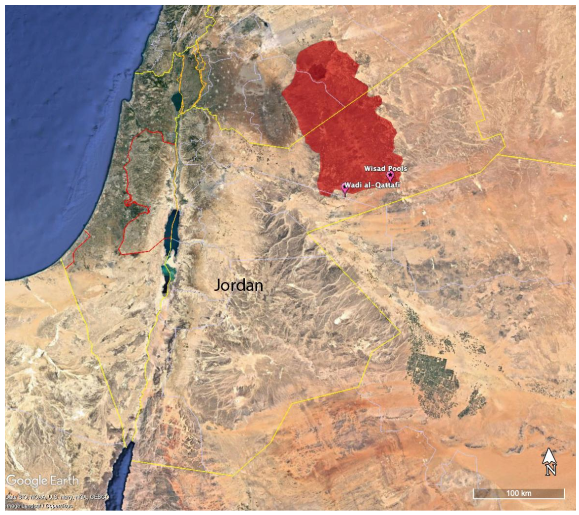
1. Introduction
Brief Intro to Neolithic Badia
2. Materials and Methods
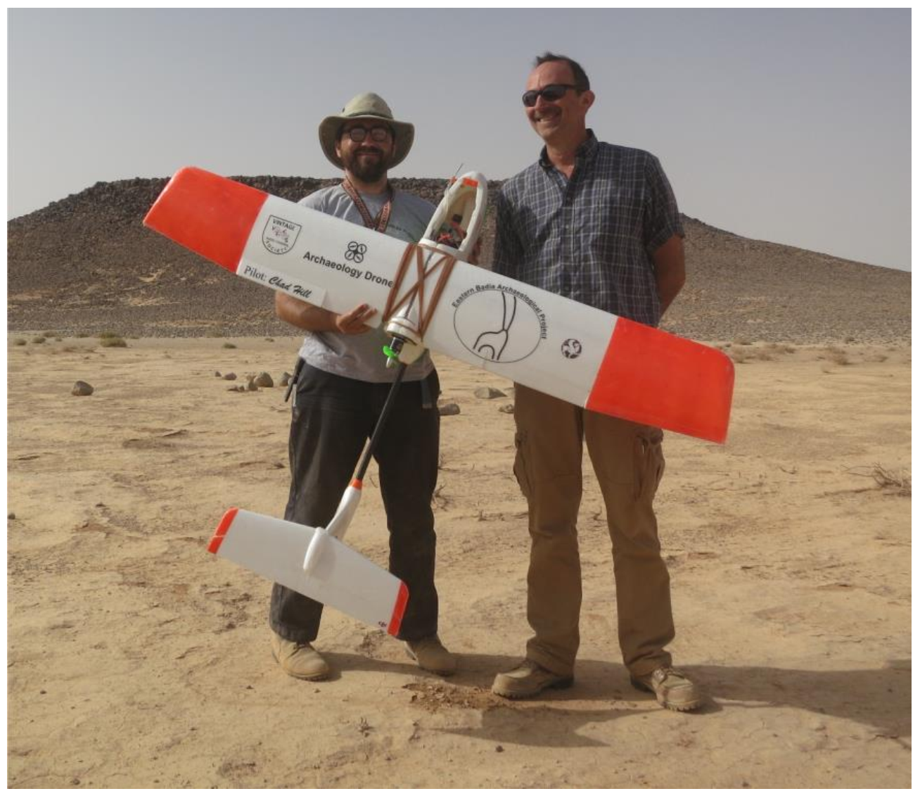
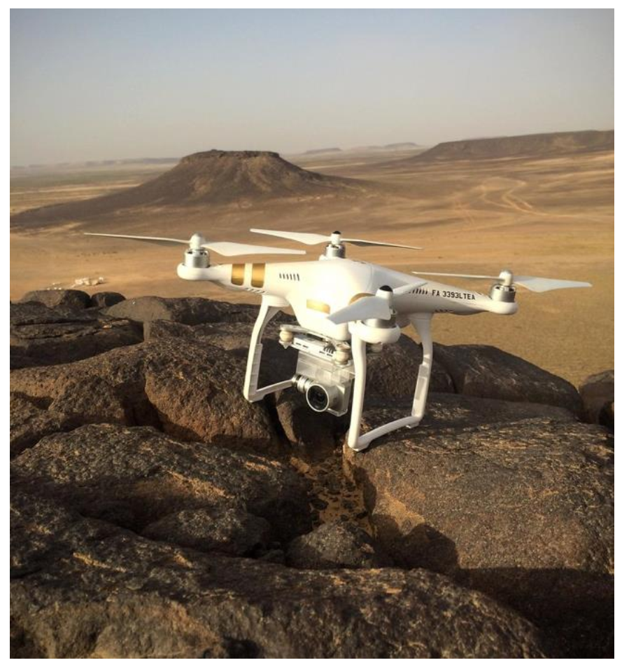
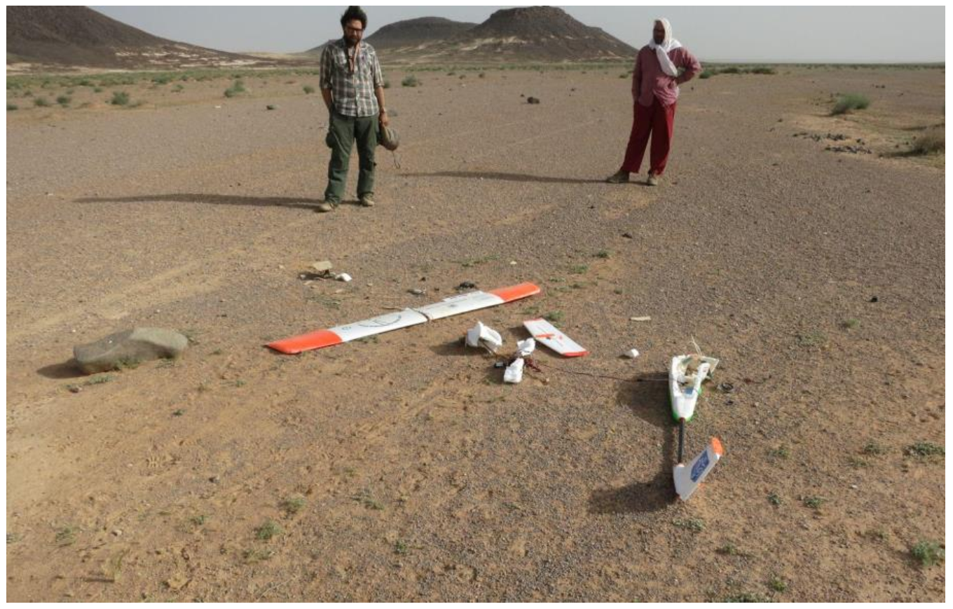
2.1. Limitations of Drone Survey in the Desert
2.2. Online Collaboration
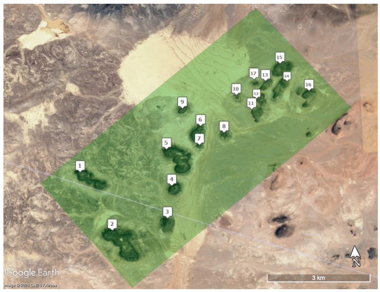
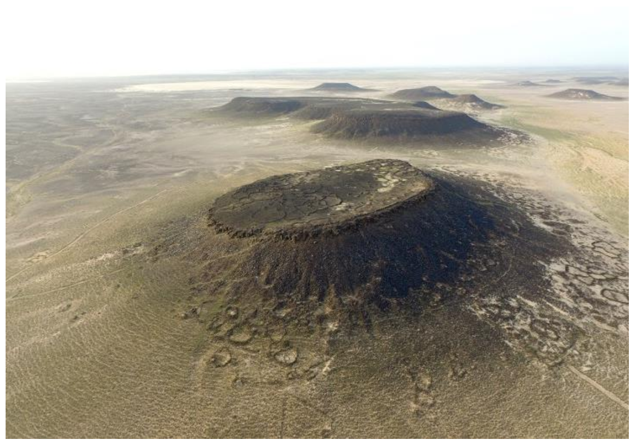
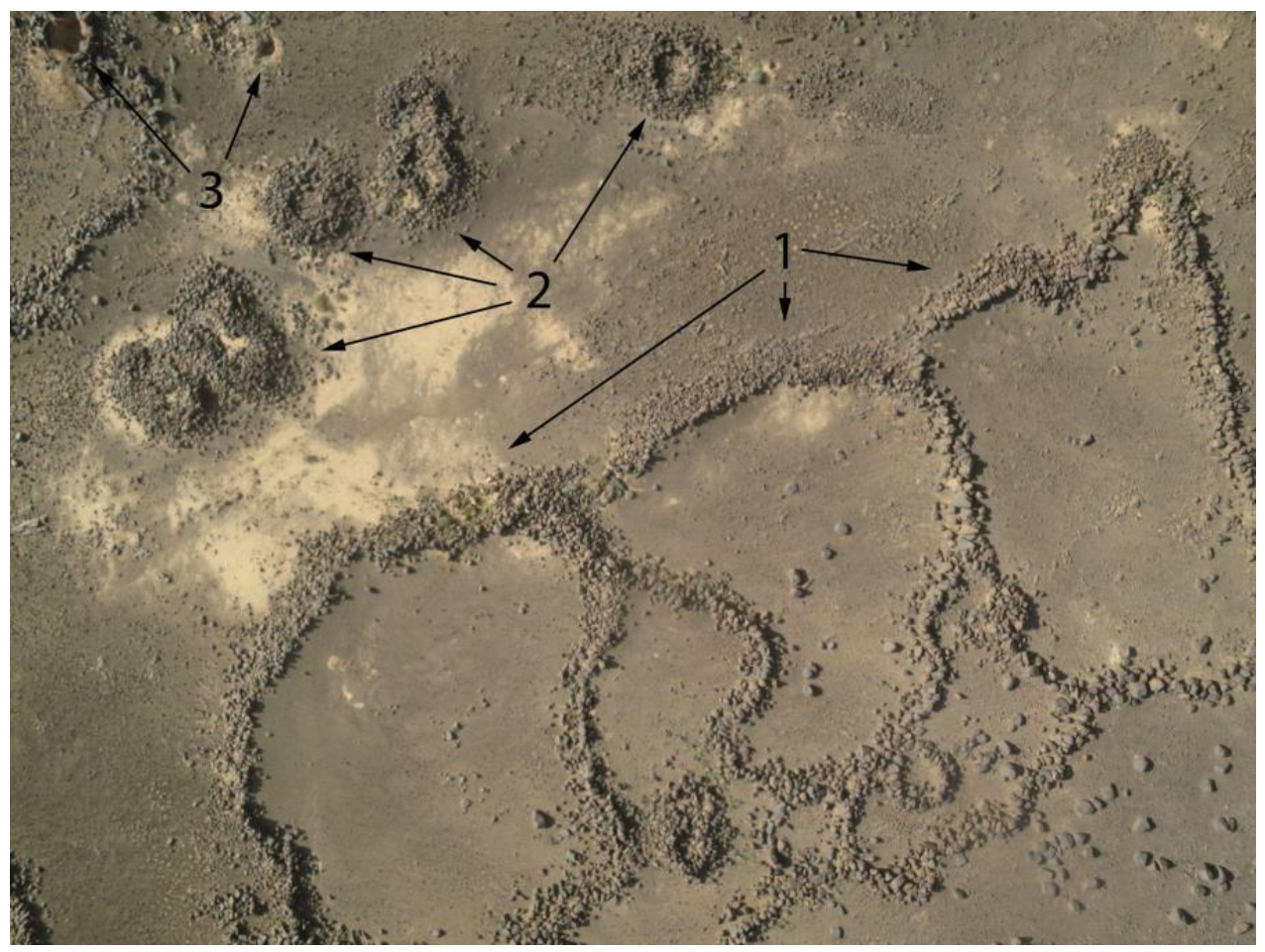
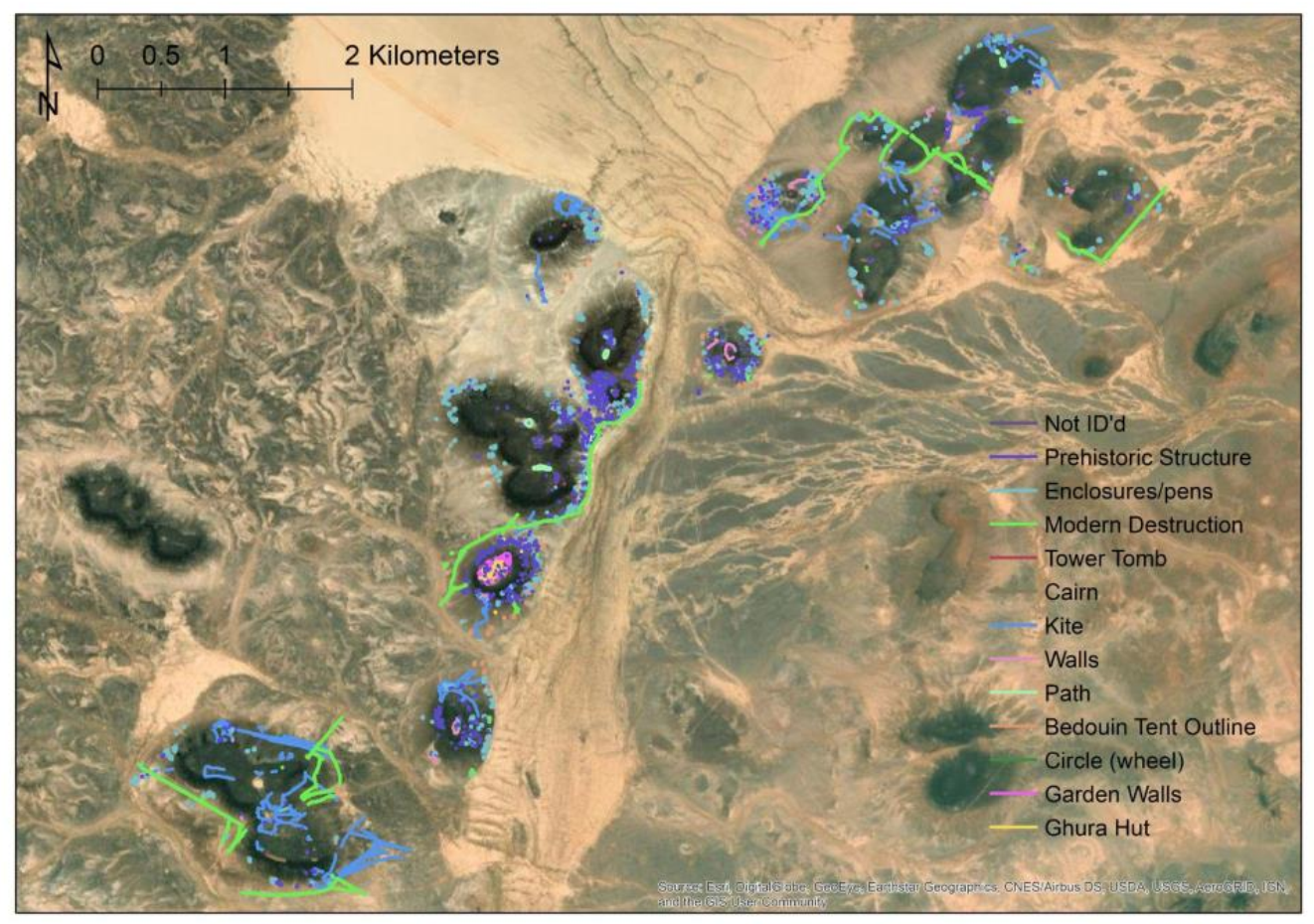
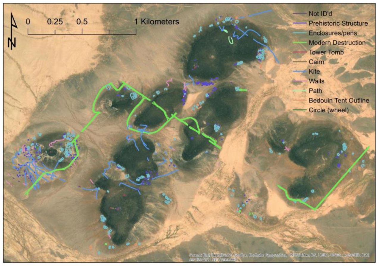
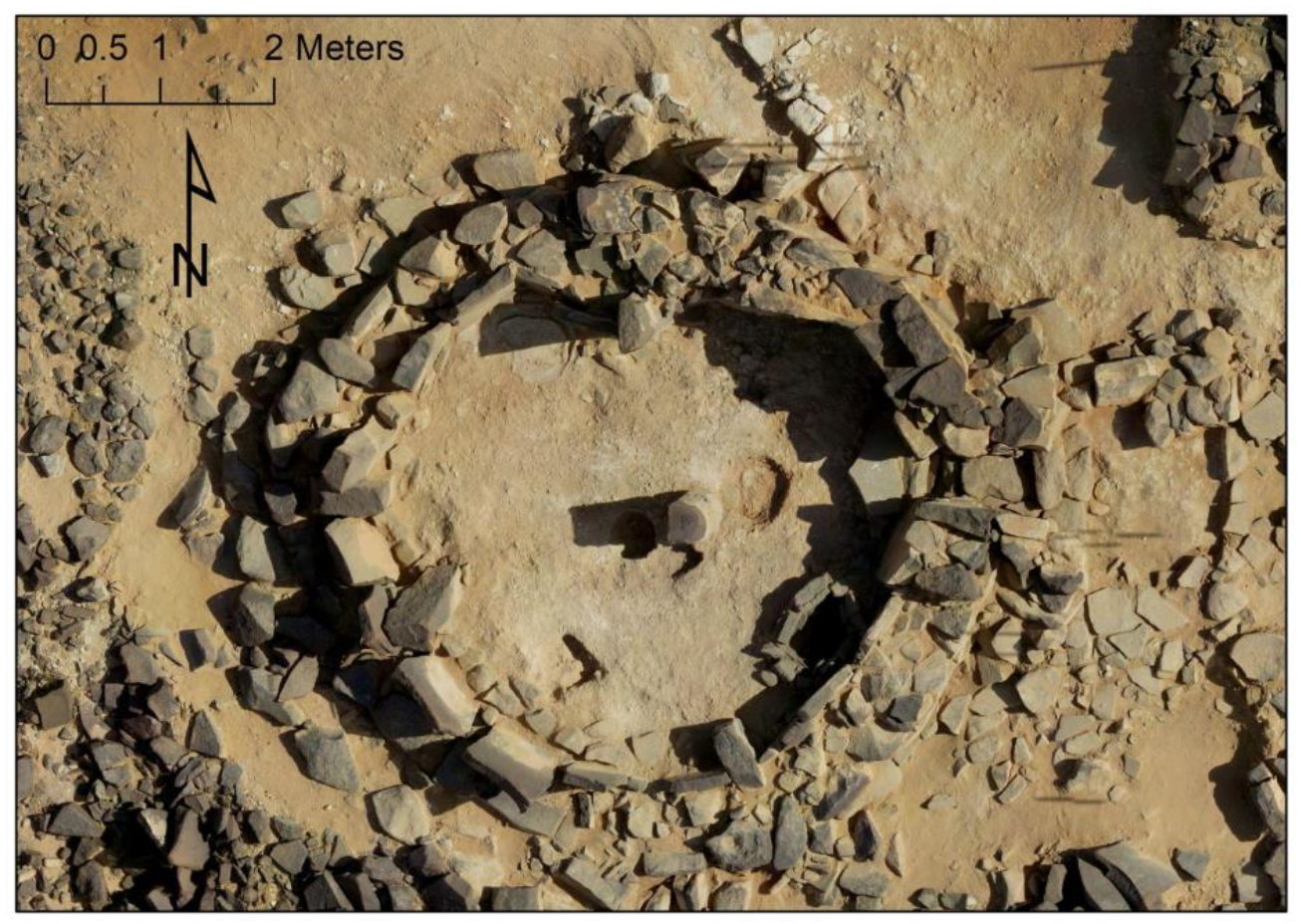
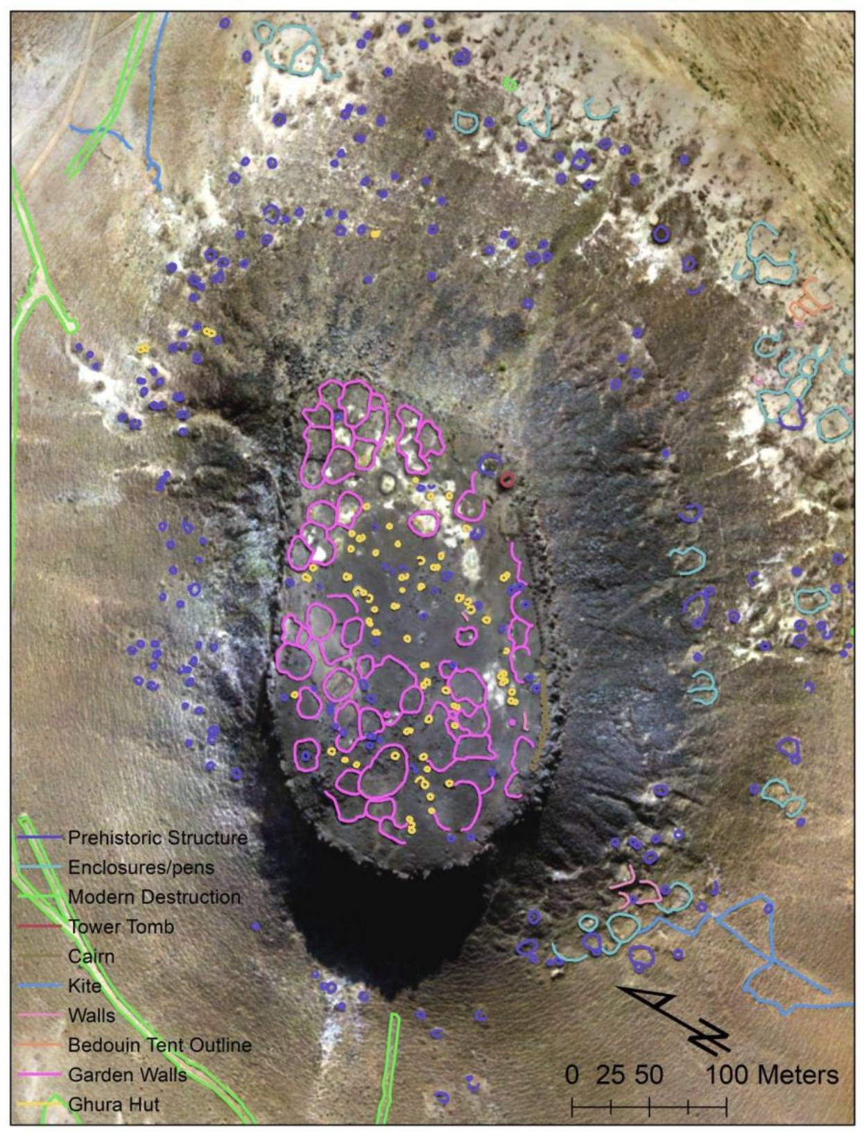
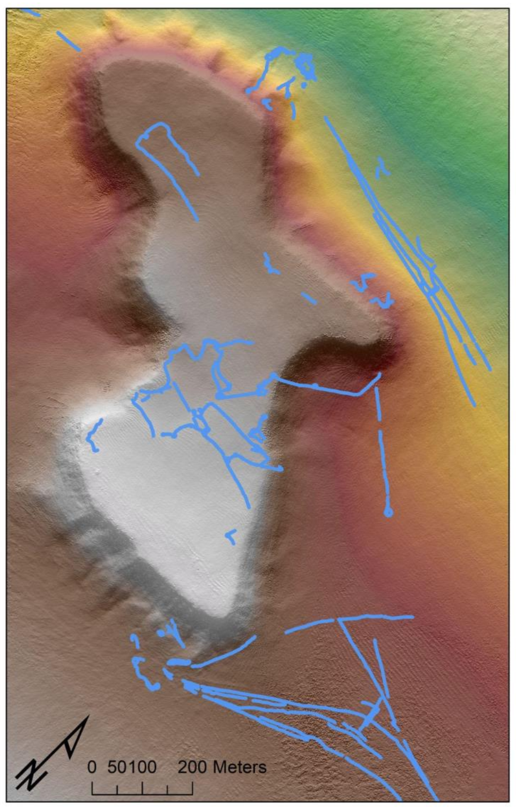
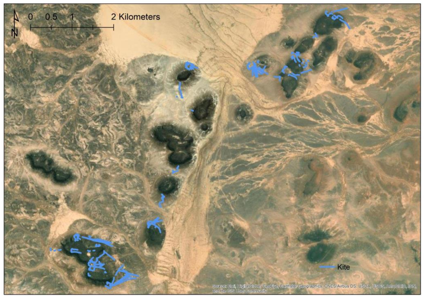
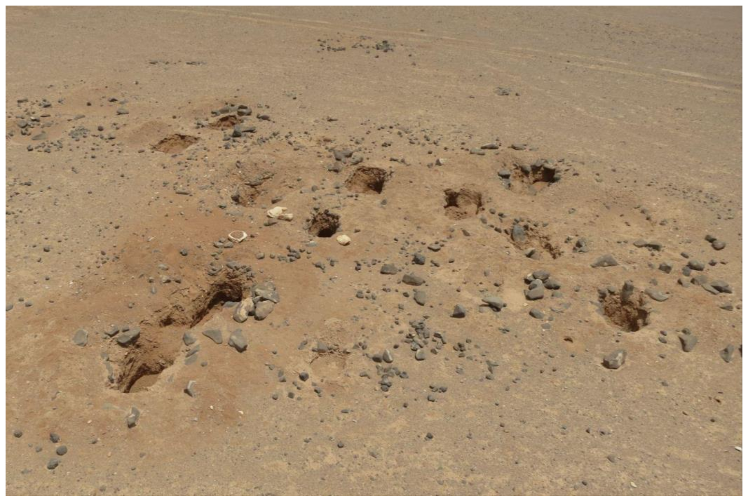
3. Results
4. Conclusions
Author Contributions
Funding
Institutional Review Board Statement
Informed Consent Statement
Data Availability Statement
Acknowledgments
Conflicts of Interest
References
- Campana, S. Drones in Archaeology. State-of-the-Art and Future Perspectives: Drones in Archaeology. Archaeol. Prospect. 2017, 24, 275–296. [Google Scholar] [CrossRef]
- Agudo, P.; Pajas, J.; Pérez-Cabello, F.; Redón, J.; Lebrón, B. The Potential of Drones and Sensors to Enhance Detection of Archaeological Cropmarks: A Comparative Study Between Multi-Spectral and Thermal Imagery. Drones 2018, 2, 29. [Google Scholar] [CrossRef]
- Olson, K.G.; Rouse, L.M. A Beginner’s Guide to Mesoscale Survey with Quadrotor-UAV Systems—CORRIGENDUM. Adv. Archaeol. Pract. 2019, 7, 215. [Google Scholar] [CrossRef]
- Chiabrando, F.; D’Andria, F.; Sammartano, G.; Spanò, A. UAV Photogrammetry for Archaeological Site Survey. 3D Models at the Hierapolis in Phrygia (Turkey). Virtual Archaeol. Rev. 2018, 9, 28–43. [Google Scholar] [CrossRef]
- Hill, A.C. UAVs at Marj Rabba, Israel: Low-Cost High-Tech Tools for Aerial Photography and Photogrammetry. SAA Archaeol. Rec. 2013, 13, 25–29. [Google Scholar]
- Gutiérrez, G.; Searcy, M.T. Introduction to the UAV Special Edition. SAA Archaeol. Rec. Spec. Issue Drones Archaeol. 2016, 16, 6–9. [Google Scholar]
- Smith, S.L. Drones over the “Black Desert”: The Advantages of Rotary-Wing UAVs for Complementing Archaeological Fieldwork in the Hard-to-Access Landscapes of Preservation of North-Eastern Jordan. Geosciences 2020, 10, 426. [Google Scholar] [CrossRef]
- Bendea, H.; Chiabrando, F.; Tonolo, F.G.; Marenchino, D. Mapping of Archaeological Areas Using a Low-Cost UAV. The Augusta Bagiennorum Test Site. In Proceedings of the XXI International CIPA Symposium, Athens, Greece, 1–6 October 2007; Volume 1. [Google Scholar]
- Risbøl, O.; Gustavsen, L. LiDAR from Drones Employed for Mapping Archaeology—Potential, Benefits and Challenges. Archaeol. Prospect. 2018, 25, 329–338. [Google Scholar] [CrossRef]
- VanValkenburgh, P.; Cushman, K.C.; Butters, L.J.C.; Vega, C.R.; Roberts, C.B.; Kepler, C.; Kellner, J. Lasers Without Lost Cities: Using Drone Lidar to Capture Architectural Complexity at Kuelap, Amazonas, Peru. J. Field Archaeol. 2020, 45, S75–S88. [Google Scholar] [CrossRef]
- Verhoeven, G.J.J. Providing an Archaeological Bird’s-Eye View—An Overall Picture of Ground-Based Means to Execute Low-Altitude Aerial Photography (LAAP) in Archaeology. Archaeol. Prospect. 2009, 16, 233–249. [Google Scholar] [CrossRef]
- Lehmann, J.R.K.; Smithson, K.Z.; Prinz, T. Making the Invisible Visible: Using UAS-Based High-Resolution Color-Infrared Imagery to Identify Buried Medieval Monastery Walls. J. Unmanned Veh. Syst. 2015, 3, 58–67. [Google Scholar] [CrossRef]
- Herrmann, J.T.; Glissmann, B.; Sconzo, P.; Pfälzner, P. Unmanned Aerial Vehicle (UAV) Survey with Commercial-Grade Instruments: A Case Study from the Eastern Ḫabur Archaeological Survey, Iraq. J. Field Archaeol. 2018, 43, 269–283. [Google Scholar] [CrossRef]
- Lech, P.; Zakrzewski, P. Depopulation and Devastation: Using GIS for Tracing Changes in the Archaeological Landscape of Kharaib Al-Dasht, a Late Islamic Fishing Village (Kuwait). Archaeol. Prospect. 2021, 28, 17–24. [Google Scholar] [CrossRef]
- Stek, T.D. Drones over Mediterranean Landscapes. The Potential of Small UAV’s (Drones) for Site Detection and Heritage Management in Archaeological Survey Projects: A Case Study from Le Pianelle in the Tappino Valley, Molise (Italy). J. Cult. Herit. 2016, 22, 1066–1071. [Google Scholar] [CrossRef]
- Yasur-Landau, A.; Shtienberg, G.; Gambash, G.; Spada, G.; Melini, D.; Arkin-Shalev, E.; Tamberino, A.; Reese, J.; Levy, T.E.; Sivan, D. New Relative Sea-Level (RSL) Indications from the Eastern Mediterranean: Middle Bronze Age to the Roman Period (~3800–1800 y BP) Archaeological Constructions at Dor, the Carmel Coast, Israel. PLoS ONE 2021, 16, e0251870. [Google Scholar] [CrossRef]
- Hill, A.; Rowan, Y.; Kersel, M.M. Mapping with Aerial Photographs: Recording the Past, the Present, and the Invisible at Marj Rabba, Israel. Near East. Archaeol. 2014, 77, 182–186. [Google Scholar] [CrossRef]
- Al Kwatli, M.A.; Gillot, P.Y.; Zeyen, H.; Hildenbrand, A.; Al Gharib, I. Volcano-Tectonic Evolution of the Northern Part of the Arabian Plate in the Light of New K–Ar Ages and Remote Sensing: Harrat Ash Shaam Volcanic Province (Syria). Tectonophysics 2012, 580, 192–207. [Google Scholar] [CrossRef]
- Ilani, S.; Harlavan, Y.; Tarawneh, K.; Rabba, I.; Weinberger, R.; Ibrahim, K.; Peltz, S.; Steinitz, G. New K-Ar Ages of Basalts from the Harrat Ash Shaam Volcanic Field in Jordan: Implications for the Span and Duration of the Upper-Mantle Upwelling beneath the Western Arabian Plate. Geology 2001, 29, 171–174. [Google Scholar] [CrossRef]
- Bender, F. Geologie von Jordanien; Regionlae Geologie Erde; Gebrueder Borntraeger: Stuttgart, Germany, 1968; Volume 7. [Google Scholar]
- Ibrahim, K. The Geological Framework for the Harrat Ash-Shaam Basaltic Super-Group and Its Volcanotectonic Evolution; 1:50,000 Geological Mapping Series Geological Bulletin; Natural Resources Authority, Geological Directorate Geological Mapping Division: Amman, Jordan, 1993. [Google Scholar]
- Rabaa’, I. The Geology of Umm Nukhayla and Wadi al Qattafi Areas Map Sheets No. 3453-II and 3453-I; 1:50,000 Geo-logical Mapping Series Geological Bulletin; Natural Resources Authority, Geological Directorate Geological Mapping Division: Amman, Jordan, 2005. [Google Scholar]
- Betts, A.V.; Colledge, S.; Martin, L.; McCartney, C.; Wright, K.; Yagodin, V. The Harra and the Hamad: Excavations and Surveys in Eastern Jordan, Volume 1; Sheffield Archaeological Monographs; Sheffield Academic Press: Sheffield, UK, 1998; Volume 9. [Google Scholar]
- Garrard, A.; Baird, D.; Colledge, S.; Martin, L.; Wright, K. Prehistoric Environment and Settlement in the Azraq Basin: An Interim Report on the 1987 and 1988 Excavation Seasons. Levant 1994, 26, 73–109. [Google Scholar] [CrossRef]
- Maher, L.A.; Macdonald, D.A. Communities of Interaction: Tradition and Learning in Stone Tool Production Through the Lens of the Epipaleolithic of Kharaneh IV, Jordan. In Culture History and Convergent Evolution; Groucutt, H.S., Ed.; Vertebrate Paleobiology and Paleoanthropology; Springer International Publishing: Cham, Switzerland, 2020; pp. 213–243. ISBN 978-3-030-46125-6. [Google Scholar]
- Meister, J.; Krause, J.; Müller-Neuhof, B.; Portillo, M.; Reimann, T.; Schütt, B. Desert Agricultural Systems at EBA Jawa (Jordan): Integrating Archaeological and Paleoenvironmental Records. Quat. Int. 2017, 434, 33–50. [Google Scholar] [CrossRef]
- Nowell, A.; Walker, C.; Cordova, C.E.; Ames, C.J.H.; Pokines, J.T.; Stueber, D.; DeWitt, R.; al-Souliman, A.S.A. Middle Pleistocene Subsistence in the Azraq Oasis, Jordan: Protein Residue and Other Proxies. J. Archaeol. Sci. 2016, 73, 36–44. [Google Scholar] [CrossRef]
- Richter, T. Natufian and Early Neolithic in the Black Desert, Eastern Jordan. In Quaternary of the Levant; Enzel, Y., Bar-Yosef, O., Eds.; Cambridge University Press: Cambridge, UK, 2017; pp. 715–722. ISBN 978-1-316-10675-4. [Google Scholar]
- Jones, M.D.; Richter, T.; Rollefson, G.; Rowan, Y.; Roe, J.; Toms, P.; Wood, J.; Wasse, A.; Ikram, H.; Williams, M.; et al. The Palaeoenvironmental Potential of the Eastern Jordanian Desert Basins (Qe’an). Quat. Int. 2021, S1040618221003724. [Google Scholar] [CrossRef]
- Rowan, Y.M.; Rollefson, G.O.; Wasse, A.; Abu-Azizeh, W.; Hill, A.C.; Kersel, M.M. The “Land of Conjecture:” New Late Prehistoric Discoveries at Maitland’s Mesa and Wisad Pools, Jordan. J. Field Archaeol. 2015, 40, 176–189. [Google Scholar] [CrossRef]
- Wasse, A.; Rowan, Y.; Rollefson, G.O. A 7th Millennium BC Late Neolithic Village at Mesa 4 in Wadi Al-Qattafi, Eastern Jordan. Neo-Lithics 2012, 1, 15–24. [Google Scholar]
- Rollefson, G.O.; Wasse, A.; Rowan, Y.; Kersel, M.; Jones, M.; Lorentzen, B.; Hill, A.C.; Ramsay, J. The 2016 Excavation Season at the Late Neolithic Structure SS-1 on Mesa 7, Black Desert. Neo-Lithics 2017, 2, 19–29. [Google Scholar]
- Rollefson, G.O.; Athanassas, C.D.; Rowan, Y.M.; Wasse, A.M. First Chronometric Results for ‘Works of the Old Men’: Late Prehistoric ‘Wheels’ near Wisad Pools, Black Desert, Jordan. Antiquity 2016, 90, 939–952. [Google Scholar] [CrossRef]
- Crassard, R.; Barge, O.; Bichot, C.-E.; Brochier, J.É.; Chahoud, J.; Chambrade, M.-L.; Chataigner, C.; Madi, K.; Régagnon, E.; Seba, H. Addressing the Desert Kites Phenomenon and Its Global Range through a Multi-Proxy Approach. J. Archaeol. Method Theory 2015, 22, 1093–1121. [Google Scholar] [CrossRef]
- Kempe, S.; Al-Malabeh, A. Hunting Kites (‘Desert Kites’) and Associated Structures along the Eastern Rim of the Jordanian Harrat: A Geo-Archaeological Google Earth Images Survey. Z. Orient-Archäol. 2010, 10, 46–86. [Google Scholar]
- Eisenbeiss, H.; Sauerbier, M. Investigation of Uav Systems and Flight Modes for Photogrammetric Applications: Investigation of UAV Systems and Flight Modes. Photogramm. Rec. 2011, 26, 400–421. [Google Scholar] [CrossRef]
- Roosevelt, C.H. Mapping Site-Level Microtopography with Real-Time Kinematic Global Navigation Satellite Systems (RTK GNSS) and Unmanned Aerial Vehicle Photogrammetry (UAVP). Open Archaeol. 2014, 1. [Google Scholar] [CrossRef]
- Hill, A.C. Economical Drone Mapping for Archaeology: Comparisons of Efficiency and Accuracy. J. Archaeol. Sci. Rep. 2019, 24, 80–91. [Google Scholar] [CrossRef]
- Dibble, H.; McPherron, S.J.P.; McPherron, T. 12V. SAA Archaeol. Rec. 2007, 7, 35–41. [Google Scholar]
- Osborne, M. Mission Planner. 2021. Available online: https://ardupilot.org/planner/ (accessed on 1 January 2022).
- Hill, A.C.; Rowan, Y.M.; Wasse, A.; Rollefson, G.O. Inscribed Landscapes in the Black Desert: Petroglyphs and Kites at Wisad Pools, Jordan. Arab. Archaeol. Epigr. 2020, 31, 245–262. [Google Scholar] [CrossRef]
- Douglass, M.; Lin, S.; Chodoronek, M. The Application of 3D Photogrammetry for In-Field Documentation of Archaeological Features. Adv. Archaeol. Pract. 2015, 3, 136–152. [Google Scholar] [CrossRef]
- Olson, B.R.; Placchetti, R.A.; Quartermaine, J.; Killebrew, A.E. The Tel Akko Total Archaeology Project (Akko, Israel): Assessing the Suitability of Multi-Scale 3D Field Recording in Archaeology. J. Field Archaeol. 2013, 38, 244–262. [Google Scholar] [CrossRef]
- Hill, A.C.; Limp, F.; Casana, J.; Laugier, E.J.; Williamson, M. A New Era in Spatial Data Recording: Low-Cost GNSS. Adv. Archaeol. Pract. 2019, 7, 169–177. [Google Scholar] [CrossRef]
- Hill, A.C.; Rowan, Y. Droning on in the Badia: UAVs and Site Documentation at Wadi al-Qattafi. Near East. Archaeol. 2017, 80, 114–123. [Google Scholar] [CrossRef]
- Ravich, T. A Comparative Global Analysis of Drone Laws: Best Practices and Policies. In The Future of Drone Use; Custers, B., Ed.; Information Technology and Law Series; T.M.C. Asser Press: The Hague, The Netherlands, 2016; Volume 27, pp. 301–322. ISBN 978-94-6265-131-9. [Google Scholar]
- Stone, E.C. Patterns of Looting in Southern Iraq. Antiquity 2008, 82, 125–138. [Google Scholar] [CrossRef]
- Danti, M.; Branting, S.; Penacho, S. The American Schools of Oriental Research Cultural Heritage Initiatives: Monitoring Cultural Heritage in Syria and Northern Iraq by Geospatial Imagery. Geosciences 2017, 7, 95. [Google Scholar] [CrossRef]
- Smith, M.L. Citizen Science in Archaeology. Am. Antiq. 2014, 79, 749–762. [Google Scholar] [CrossRef][Green Version]
- Casana, J. Global-Scale Archaeological Prospection Using CORONA Satellite Imagery: Automated, Crowd-Sourced, and Expert-Led Approaches. J. Field Archaeol. 2020, 45, S89–S100. [Google Scholar] [CrossRef]
- Casana, J. Regional-Scale Archaeological Remote Sensing in the Age of Big Data: Automated Site Discovery vs. Brute Force Methods. Adv. Archaeol. Pract. 2014, 2, 222–233. [Google Scholar] [CrossRef]
- Masini, N.; Lasaponara, R. Remote and Close Range Sensing for the Automatic Identification and Characterization of Archaeological Looting. The Case of Peru. J. Comput. Appl. Archaeol. 2021, 4, 126–144. [Google Scholar] [CrossRef]
- Davis, D.S. Object-based Image Analysis: A Review of Developments and Future Directions of Automated Feature Detection in Landscape Archaeology. Archaeol. Prospect. 2019, 26, 155–163. [Google Scholar] [CrossRef]
- Trier, Ø.D.; Zortea, M.; Tonning, C. Automatic Detection of Mound Structures in Airborne Laser Scanning Data. J. Archaeol. Sci. Rep. 2015, 2, 69–79. [Google Scholar] [CrossRef]
- Verschoof-van der Vaart, W.B.; Lambers, K. Learning to Look at LiDAR: The Use of R-CNN in the Automated Detection of Archaeological Objects in LiDAR Data from the Netherlands. J. Comput. Appl. Archaeol. 2019, 2, 31–40. [Google Scholar] [CrossRef]
- Rowan, Y.M.; Rollefson, G.O.; Wasse, A. Populating the Black Desert. The Late Neolithic Presence. In Landscapes of Survival: The Archaeology and Epigraphy of Jordan’s North-Eastern Desert and Beyond; Akkermans, P.M., Ed.; Sidestone Press: Leiden, The Netherlands, 2020. [Google Scholar]
- Rollefson, G.; Rowan, Y.; Wasse, A. The Late Neolithic Colonization of the Eastern Badia of Jordan. Levant 2014, 46, 285–301. [Google Scholar] [CrossRef]
- Wasse, A.; Rowan, Y.M.; Rollefson, G.O. Flamingos in the Desert. In Landscapes of Survival: The Archaeology and Epigraphy of Jordan’s North-Eastern Desert and Beyond; Akkermans, P.M., Ed.; Sidestone Press: Leiden, The Netherlands, 2020. [Google Scholar]
- Akkermans, P.M.M.G.; Brüning, M.L. Nothing but Cold Ashes? The Cairn Burials of Jebel Qurma, Northeastern Jordan. Near East. Archaeol. 2017, 80, 132–139. [Google Scholar] [CrossRef]
- Müller-Neuhof, B.; Abu-Azizeh, W. Milestones for a Tentative Chronological Framework for the Late Prehistoric Colonization of the Basalt Desert (North-Eastern Jordan). Levant 2016, 48, 220–235. [Google Scholar] [CrossRef]
- Müller-Neuhof, B. A ‘Marginal’ Region with Many Options: The Diversity of Chalcolithic/Early Bronze Age Socio-Economic Activities in the Hinterland of Jawa. Levant 2014, 46, 230–248. [Google Scholar] [CrossRef]
- Müller-Neuhof, B.; Abu Azizeh, W. Insights into the Chalcolithic / Early Bronze Age Colonization of the Harra (NE-Jordan)—Part I: Tūlūl al-Ghuṣayn. Annu. Dep. Antiq. Jordan 2018, 59, 411–424. [Google Scholar]
- Hammer, E.; Lauricella, A. Historical Imagery of Desert Kites in Eastern Jordan. Near East. Archaeol. 2017, 80, 74–83. [Google Scholar] [CrossRef]
- Helms, S.; Betts, A. The Desert “Kites” of the Badiyat Esh-Sham and North Arabia. Paléorient 1987, 13, 41–67. [Google Scholar] [CrossRef]
- Abu-Azizeh, W.; Tarawneh, M.B. Out of the Harra: Desert Kites in South-Eastern Jordan. New Results from the South Eastern Badia Archaeological Project. Arab. Archaeol. Epigr. 2015, 26, 95–119. [Google Scholar] [CrossRef]
- Contreras, D.A.; Brodie, N. The Utility of Publicly-Available Satellite Imagery for Investigating Looting of Archaeological Sites in Jordan. J. Field Archaeol. 2010, 35, 101–114. [Google Scholar] [CrossRef]
- Kersel, M.M.; Hill, A. The (W)Hole Picture: Responses to a Looted Landscape. Int. J. Cult. Prop. 2019, 26, 305–329. [Google Scholar] [CrossRef]
- Casana, J. Satellite Imagery-Based Analysis of Archaeological Looting in Syria. Near East. Archaeol. 2015, 78, 142–152. [Google Scholar] [CrossRef]
- Casana, J.; Laugier, E.J. Satellite Imagery-Based Monitoring of Archaeological Site Damage in the Syrian Civil War. PLoS ONE 2017, 12, e0188589. [Google Scholar] [CrossRef]
- Stone, E.C. An Update on the Looting of Archaeological Sites in Iraq. Near East. Archaeol. 2015, 78, 178–186. [Google Scholar] [CrossRef][Green Version]
- Contreras, D.A. Huaqueros and Remote Sensing Imagery: Assessing Looting Damage in the Virú Valley, Peru. Antiquity 2010, 84, 544–555. [Google Scholar] [CrossRef]
- Tapete, D.; Cigna, F. Detection of Archaeological Looting from Space: Methods, Achievements and Challenges. Remote Sens. 2019, 11, 2389. [Google Scholar] [CrossRef]
- Lauricella, A.; Cannon, J.; Branting, S.; Hammer, E. Semi-Automated Detection of Looting in Afghanistan Using Multispectral Imagery and Principal Component Analysis. Antiquity 2017, 91, 1344–1355. [Google Scholar] [CrossRef]
- Akkermans, P.M.; Huigens, H.O.; Brüning, M.L. A Landscape of Preservation: Late Prehistoric Settlement and Sequence in the Jebel Qurma Region, North-Eastern Jordan. Levant 2014, 46, 186–205. [Google Scholar] [CrossRef]
- Akkermans, P.M.M.G.; Bruning, M.L. East of Azraq: Settlement, Burial and Chronology from the Chalcolithic to the Bronze Age and Iron Age in the Jebel Qurma Region, Black Desert, North-East Jordan. In Landscapes of Survival; Akkermans, P.M.M.G., Ed.; Sidestone Press: Leiden, The Netherlands, 2020; pp. 185–215. [Google Scholar]


| Mesa # | 1/Anthropogenic Structures | 2/Enclosure/Pen | 3/Modern Destruction/Building | 4/Tower Tomb | 5/Cairn/Tail | 6/Kite | 7/Wall | 8/Path | 9/Bedouin Tent Outline | 10/Circle (Wheel) | 11/Garden Wall | 12/Ghura Hut | Total |
|---|---|---|---|---|---|---|---|---|---|---|---|---|---|
| 2 | 57 | 45 | 3 | 2 | 48 | 3 | 3 | 0 | 0 | 0 | 0 | 0 | 161 |
| 3 | 97 | 40 | 2 | 1 | 0 | 1 | 4 | 0 | 4 | 0 | 0 | 0 | 149 |
| 4 | 318 | 24 | 2 | 1 | 42 | 0 | 2 | 0 | 10 | 0 | 54 | 63 | 516 |
| 5 | 80 | 74 | 1 | 6 | 0 | 0 | 1 | 2 | 0 | 0 | 0 | 0 | 164 |
| 6 | 91 | 37 | 0 | 0 | 0 | 0 | 1 | 1 | 1 | 0 | 0 | 0 | 131 |
| 7 | 66 | 31 | 1 | 1 | 0 | 0 | 3 | 0 | 1 | 1 | 0 | 1 | 105 |
| 8 | 84 | 44 | 3 | 2 | 0 | 0 | 3 | 0 | 11 | 0 | 0 | 0 | 147 |
| 9 | 11 | 33 | 0 | 1 | 0 | 1 | 0 | 0 | 9 | 0 | 0 | 0 | 55 |
| 10 | 95 | 61 | 1 | 1 | 0 | 1 | 12 | 0 | 7 | 0 | 0 | 0 | 178 |
| 11 | 4 | 39 | 3 | 3 | 12 | 0 | 2 | 0 | 2 | 0 | 0 | 0 | 65 |
| 12 | 30 | 20 | 0 | 0 | 0 | 1 | 2 | 0 | 0 | 0 | 0 | 0 | 53 |
| 13 | 29 | 3 | 1 | 0 | 0 | 1 | 4 | 0 | 0 | 0 | 0 | 0 | 38 |
| 14 | 28 | 29 | 1 | 0 | 0 | 0 | 1 | 0 | 3 | 0 | 0 | 0 | 62 |
| 15 | 100 | 52 | 0 | 2 | 1 | 0 | 2 | 3 | 0 | 0 | 0 | 160 | |
| 16 | 8 | 36 | 1 | 0 | 0 | 0 | 2 | 0 | 1 | 0 | 0 | 0 | 48 |
| 17 | 10 | 9 | 1 | 0 | 0 | 0 | 0 | 0 | 0 | 0 | 0 | 0 | 20 |
| Total | 1108 | 577 | 20 | 20 | 102 | 9 | 40 | 5 | 52 | 1 | 54 | 64 | 2052 |
| Orthophoto of Mesa # | Total Images | Number of Images Used in Orthophoto | Cm/Pixel of Orthophoto |
|---|---|---|---|
| 2 | 1430 | 754 | 8.4 |
| 3 | 460 | 227 | 5.7 |
| 4 | 1017 | 363 | 2.4 |
| 5 | 786 | 471 | 9 |
| 6 + 7 | 801 | 462 | 3.4 |
| 8 | 368 | 282 | 4.1 |
| 9 | 479 | 325 | 3.9 |
| 10–17 | 3600 | 3234 | 7.5 |
Publisher’s Note: MDPI stays neutral with regard to jurisdictional claims in published maps and institutional affiliations. |
© 2022 by the authors. Licensee MDPI, Basel, Switzerland. This article is an open access article distributed under the terms and conditions of the Creative Commons Attribution (CC BY) license (https://creativecommons.org/licenses/by/4.0/).
Share and Cite
Hill, A.C.; Rowan, Y.M. The Black Desert Drone Survey: New Perspectives on an Ancient Landscape. Remote Sens. 2022, 14, 702. https://doi.org/10.3390/rs14030702
Hill AC, Rowan YM. The Black Desert Drone Survey: New Perspectives on an Ancient Landscape. Remote Sensing. 2022; 14(3):702. https://doi.org/10.3390/rs14030702
Chicago/Turabian StyleHill, Austin Chad, and Yorke M. Rowan. 2022. "The Black Desert Drone Survey: New Perspectives on an Ancient Landscape" Remote Sensing 14, no. 3: 702. https://doi.org/10.3390/rs14030702
APA StyleHill, A. C., & Rowan, Y. M. (2022). The Black Desert Drone Survey: New Perspectives on an Ancient Landscape. Remote Sensing, 14(3), 702. https://doi.org/10.3390/rs14030702