


A Review of Reconstructing Remotely Sensed Land Surface Temperature under Cloudy Conditions

Abstract
1. Introduction
2. Bibliometric Analysis of the Published Literature on LST Reconstruction under Cloudy Conditions
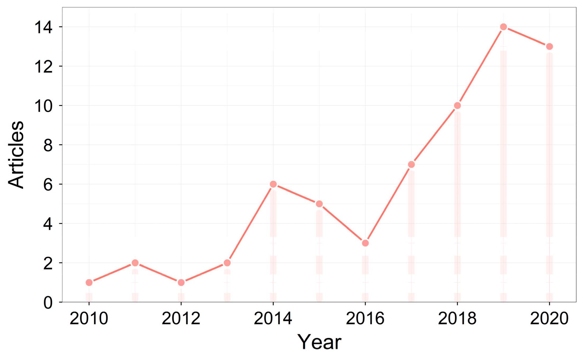
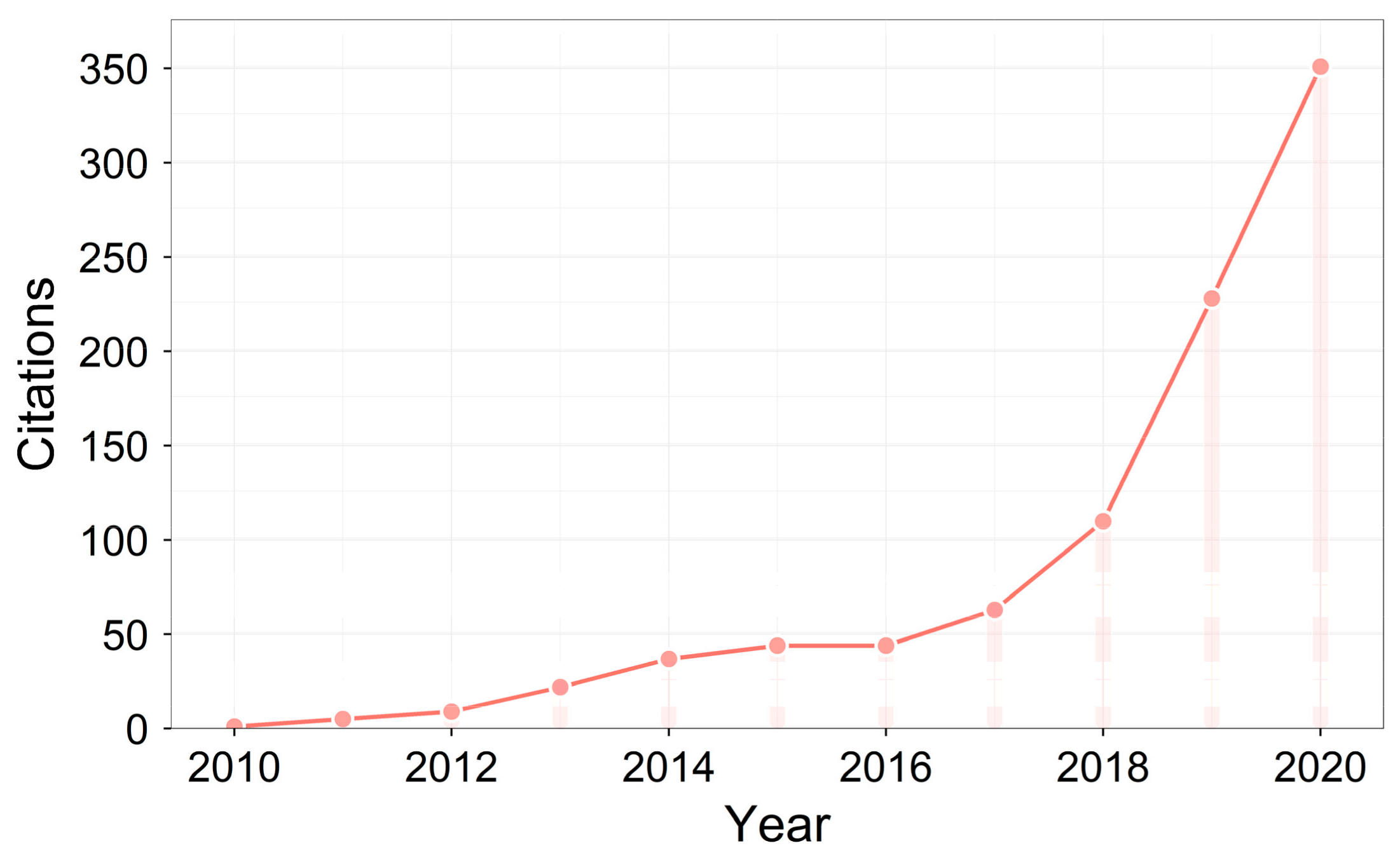
2.1. Variations in the Number of Published Papers
2.2. Most Relevant Journals
2.3. Most-Cited Papers
2.4. Most-Contributed Countries
3. Temperature Datasets Used for LST Reconstruction
3.1. LST from Polar-Orbiting Satellite Thermal Infrared Data
3.2. LST from Geostationary Satellite Thermal Infrared Data
3.3. Subsurface Temperature from Space-Borne Microwave Data
3.4. Temperature from Reanalysis Data
4. Methods of LST Reconstruction
4.1. Spatial Gap-Filling Methods
4.2. Temporal Gap-Filling Methods
4.3. Spatiotemporal Gap-Filling Methods
4.4. Multi-Source Fusion-Based Gap-Filling Methods
4.5. Surface Energy Balance-Based Gap-Filling Methods
5. Validation of Reconstructed LST
5.1. Validations Based on Artificially Simulated Cloud-Contaminated LST
5.2. Validations Based on Ground-Observed LST Data
5.3. Validations Based on Meteorological Station-Observed Temperature Data
5.4. Validations Based on Gridded Temperature Data from Other Sources
6. Conclusions and Perspectives
Author Contributions
Funding
Institutional Review Board Statement
Informed Consent Statement
Conflicts of Interest
References
- Yu, X.; Guo, X.; Wu, Z. Land Surface Temperature Retrieval from Landsat 8 TIRS—Comparison between Radiative Transfer Equation-Based Method, Split Window Algorithm and Single Channel Method. Remote Sens. 2014, 6, 9829–9852. [Google Scholar] [CrossRef] [Scilit]
- Kayet, N.; Pathak, K.; Chakrabarty, A.; Sahoo, S. Spatial Impact of Land Use/Land Cover Change on Surface Temperature Distribution in Saranda Forest, Jharkhand. Model. Earth Syst. Environ. 2016, 2, 1–10. [Google Scholar] [CrossRef] [Scilit]
- Zhou, J.; Liang, S.; Cheng, J.; Wang, Y.; Ma, J. The GLASS Land Surface Temperature Product. IEEE J. Sel. Top. Appl. Earth Obs. Remote Sens. 2018, 12, 493–507. [Google Scholar] [CrossRef] [Scilit]
- Bechtel, B. A New Global Climatology of Annual Land Surface Temperature. Remote Sens. 2015, 7, 2850–2870. [Google Scholar] [CrossRef] [Scilit]
- Huang, B.; Wang, J.; Song, H.; Fu, D.; Wong, K. Generating High Spatiotemporal Resolution Land Surface Temperature for Urban Heat Island Monitoring. IEEE Geosci. Remote Sens. Lett. 2013, 10, 1011–1015. [Google Scholar] [CrossRef] [Scilit]
- Mallick, J.; Rahman, A.; Singh, C.K. Modeling Urban Heat Islands in Heterogeneous Land Surface and Its Correlation with Impervious Surface Area by Using Night-Time ASTER Satellite Data in Highly Urbanizing City, Delhi-India. Adv. Space Res. 2013, 52, 639–655. [Google Scholar] [CrossRef] [Scilit]
- Rohde, R.; Muller, R.A.; Jacobsen, R.; Muller, E.; Perlmutter, S.; Rosenfeld, A.; Wurtele, J.; Groom, D.; Wickham, C. A New Estimate of the Average Earth Surface Land Temperature Spanning 1753 to 2011, Geoinfor Geostat: An Overview 1:1. Of 2013, 7, 2. [Google Scholar]
- Liu, H.; Weng, Q. An Examination of the Effect of Landscape Pattern, Land Surface Temperature, and Socioeconomic Conditions on WNV Dissemination in Chicago. Environ. Monit. Assess. 2009, 159, 143–161. [Google Scholar] [CrossRef] [Scilit]
- Ullah, M.; Li, J.; Wadood, B. Analysis of Urban Expansion and Its Impacts on Land Surface Temperature and Vegetation Using RS and GIS, a Case Study in Xi’an City, China. Earth Syst. Environ. 2020, 4, 583–597. [Google Scholar] [CrossRef] [Scilit]
- Kustas, W.; Anderson, M. Advances in Thermal Infrared Remote Sensing for Land Surface Modeling. Agric. For. Meteorol. 2009, 149, 2071–2081. [Google Scholar] [CrossRef] [Scilit]
- Zhang, R.; Tian, J.; Su, H.; Sun, X.; Chen, S.; Xia, J. Two Improvements of an Operational Two-Layer Model for Terrestrial Surface Heat Flux Retrieval. Sensors 2008, 8, 6165–6187. [Google Scholar] [CrossRef] [Scilit] [PubMed]
- Brunsell, N.A.; Gillies, R.R. Length Scale Analysis of Surface Energy Fluxes Derived from Remote Sensing. J. Hydrometeorol. 2003, 4, 1212–1219. [Google Scholar] [CrossRef] [Scilit]
- Anderson, M.C.; Norman, J.M.; Kustas, W.P.; Houborg, R.; Starks, P.J.; Agam, N. A Thermal-Based Remote Sensing Technique for Routine Mapping of Land-Surface Carbon, Water and Energy Fluxes from Field to Regional Scales. Remote Sens. Environ. 2008, 112, 4227–4241. [Google Scholar] [CrossRef] [Scilit]
- Li, Z.-L.; Tang, B.-H.; Wu, H.; Ren, H.; Yan, G.; Wan, Z.; Trigo, I.F.; Sobrino, J.A. Satellite-Derived Land Surface Temperature: Current Status and Perspectives. Remote Sens. Environ. 2013, 131, 14–37. [Google Scholar] [CrossRef] [Scilit]
- Jiménez-Muñoz, J.C.; Sobrino, J.A. A Generalized Single-Channel Method for Retrieving Land Surface Temperature from Remote Sensing Data. J. Geophys. Res. Atmos. 2003, 108. [Google Scholar] [CrossRef] [Scilit]
- Qin, Z.; Karnieli, A.; Berliner, P. A Mono-Window Algorithm for Retrieving Land Surface Temperature from Landsat TM Data and Its Application to the Israel-Egypt Border Region. Int. J. Remote Sens. 2001, 22, 3719–3746. [Google Scholar] [CrossRef] [Scilit]
- Wan, Z.; Dozier, J. A Generalized Split-Window Algorithm for Retrieving Land-Surface Temperature from Space. IEEE Trans. Geosci. Remote Sens. 1996, 34, 892–905. [Google Scholar]
- Jiménez-Muñoz, J.C.; Sobrino, J.A.; Skoković, D.; Mattar, C.; Cristóbal, J. Land Surface Temperature Retrieval Methods from Landsat-8 Thermal Infrared Sensor Data. IEEE Geosci. Remote Sens. Lett. 2014, 11, 1840–1843. [Google Scholar] [CrossRef] [Scilit]
- Rozenstein, O.; Qin, Z.; Derimian, Y.; Karnieli, A. Derivation of Land Surface Temperature for Landsat-8 TIRS Using a Split Window Algorithm. Sensors 2014, 14, 5768–5780. [Google Scholar] [CrossRef] [Scilit]
- Wan, Z. New Refinements and Validation of the MODIS Land-Surface Temperature/Emissivity Products. Remote Sens. Environ. 2008, 112, 59–74. [Google Scholar] [CrossRef] [Scilit]
- Gillespie, A.R.; Rokugawa, S.; Hook, S.J.; Matsunaga, T.; Kahle, A.B. Temperature/Emissivity Separation Algorithm Theoretical Basis Document, Version 2.4; ATBD Contract NAS5-31372; NASA: Washington, DC, USA, 1999. [Google Scholar]
- Freitas, S.C.; Trigo, I.F.; Macedo, J.; Barroso, C.; Silva, R.; Perdigão, R. Land Surface Temperature from Multiple Geostationary Satellites. Int. J. Remote Sens. 2013, 34, 3051–3068. [Google Scholar] [CrossRef] [Scilit]
- Aria, M.; Cuccurullo, C. Bibliometrix: An R-Tool for Comprehensive Science Mapping Analysis. J. Informetr. 2017, 11, 959–975. [Google Scholar] [CrossRef] [Scilit]
- Neteler, M. Estimating Daily Land Surface Temperatures in Mountainous Environments by Reconstructed MODIS LST Data. Remote Sens. 2010, 2, 333–351. [Google Scholar] [CrossRef] [Scilit]
- Duan, S.-B.; Li, Z.-L.; Leng, P. A Framework for the Retrieval of All-Weather Land Surface Temperature at a High Spatial Resolution from Polar-Orbiting Thermal Infrared and Passive Microwave Data. Remote Sens. Environ. 2017, 195, 107–117. [Google Scholar] [CrossRef] [Scilit]
- Crosson, W.L.; Al-Hamdan, M.Z.; Hemmings, S.N.; Wade, G.M. A Daily Merged MODIS Aqua–Terra Land Surface Temperature Data Set for the Conterminous United States. Remote Sens. Environ. 2012, 119, 315–324. [Google Scholar] [CrossRef] [Scilit]
- Weng, Q.; Fu, P. Modeling Annual Parameters of Clear-Sky Land Surface Temperature Variations and Evaluating the Impact of Cloud Cover Using Time Series of Landsat TIR Data. Remote Sens. Environ. 2014, 140, 267–278. [Google Scholar] [CrossRef] [Scilit]
- Lu, L.; Venus, V.; Skidmore, A.; Wang, T.; Luo, G. Estimating Land-Surface Temperature under Clouds Using MSG/SEVIRI Observations. Int. J. Appl. Earth Obs. Geoinf. 2011, 13, 265–276. [Google Scholar] [CrossRef] [Scilit]
- Xu, Y.; Shen, Y. Reconstruction of the Land Surface Temperature Time Series Using Harmonic Analysis. Comput. Geosci. 2013, 61, 126–132. [Google Scholar] [CrossRef] [Scilit]
- Li, X.; Zhou, Y.; Asrar, G.R.; Zhu, Z. Creating a Seamless 1 Km Resolution Daily Land Surface Temperature Dataset for Urban and Surrounding Areas in the Conterminous United States. Remote Sens. Environ. 2018, 206, 84–97. [Google Scholar] [CrossRef] [Scilit]
- Zeng, C.; Long, D.; Shen, H.; Wu, P.; Cui, Y.; Hong, Y. A Two-Step Framework for Reconstructing Remotely Sensed Land Surface Temperatures Contaminated by Cloud. ISPRS J. Photogramm. Remote Sens. 2018, 141, 30–45. [Google Scholar] [CrossRef] [Scilit]
- Prigent, C.; Jimenez, C.; Aires, F. Toward “All Weather,” Long Record, and Real-Time Land Surface Temperature Retrievals from Microwave Satellite Observations. J. Geophys. Res. Atmos. 2016, 121, 5699–5717. [Google Scholar] [CrossRef] [Scilit]
- Sun, L.; Chen, Z.; Gao, F.; Anderson, M.; Song, L.; Wang, L.; Hu, B.; Yang, Y. Reconstructing Daily Clear-Sky Land Surface Temperature for Cloudy Regions from MODIS Data. Comput. Geosci. 2017, 105, 10–20. [Google Scholar] [CrossRef] [Scilit]
- Gao, H.; Fu, R.; Dickinson, R.E.; Juárez, R.I.N. A Practical Method for Retrieving Land Surface Temperature from AMSR-E over the Amazon Forest. IEEE Trans. Geosci. Remote Sens. 2007, 46, 193–199. [Google Scholar] [CrossRef] [Scilit]
- Wu, P.; Yin, Z.; Yang, H.; Wu, Y.; Ma, X. Reconstructing Geostationary Satellite Land Surface Temperature Imagery Based on a Multiscale Feature Connected Convolutional Neural Network. Remote Sens. 2019, 11, 300. [Google Scholar] [CrossRef] [Scilit]
- Willmott, C.J.; Matsuura, K. Smart Interpolation of Annually Averaged Air Temperature in the United States. J. Appl. Meteorol. 1995, 34, 2577–2586. [Google Scholar] [CrossRef] [Scilit]
- Zhou, Y.; Qin, Z.; Bao, G. Land Surface Temperature Estimation under Cloud Cover with GIDS. Yaogan Xuebao- J. Remote Sens. 2012, 16, 492–504. [Google Scholar]
- Ke, L.; Song, C.; Ding, X. Reconstructing Complete Modis Lst Based on Temperature Gradients in Northeastern Qinghai-Tibet Plateau. In Proceedings of the 2012 IEEE International Geoscience and Remote Sensing Symposium, Munich, Germany, 22–27 July 2012; pp. 3505–3508. [Google Scholar]
- Ke, L.; Ding, X.; Song, C. Reconstruction of Time-Series MODIS LST in Central Qinghai-Tibet Plateau Using Geostatistical Approach. IEEE Geosci. Remote Sens. Lett. 2013, 10, 1602–1606. [Google Scholar] [CrossRef] [Scilit]
- Zhang, G.; Xiao, X.; Dong, J.; Kou, W.; Jin, C.; Qin, Y.; Zhou, Y.; Wang, J.; Menarguez, M.A.; Biradar, C. Mapping Paddy Rice Planting Areas through Time Series Analysis of MODIS Land Surface Temperature and Vegetation Index Data. ISPRS J. Photogramm. Remote Sens. 2015, 106, 157–171. [Google Scholar] [CrossRef] [Scilit]
- Coops, N.C.; Duro, D.C.; Wulder, M.A.; Han, T. Estimating Afternoon MODIS Land Surface Temperatures (LST) Based on Morning MODIS Overpass, Location and Elevation Information. Int. J. Remote Sens. 2007, 28, 2391–2396. [Google Scholar] [CrossRef] [Scilit]
- Julien, Y.; Sobrino, J.A.; Verhoef, W. Changes in Land Surface Temperatures and NDVI Values over Europe between 1982 and 1999. Remote Sens. Environ. 2006, 103, 43–55. [Google Scholar] [CrossRef] [Scilit]
- Van De Kerchove, R.; Lhermitte, S.; Veraverbeke, S.; Goossens, R. Spatio-Temporal Variability in Remotely Sensed Land Surface Temperature, and Its Relationship with Physiographic Variables in the Russian Altay Mountains. Int. J. Appl. Earth Obs. Geoinf. 2013, 20, 4–19. [Google Scholar] [CrossRef] [Scilit]
- Van den Bergh, F.; Van Wyk, M.A.; Van Wyk, B.J. Comparison of data-driven and model-driven approaches to brightness temperature diurnal cycle interpolation. In Proceedings of the 17th Annual Symposium of the Pattern Recognition Association of South Africa, Parys, South Africa, 29 November–1 December 2006. [Google Scholar]
- Schmidt, A.; Bandar, Z. A Modular Neural Network Architecture with Additional Generalization Abilities for Large Input Vectors. In Proceedings of the Artificial Neural Nets and Genetic Algorithms, Norwich, UK, 22 June 1998; pp. 35–39. [Google Scholar]
- Liu, Z.; Zhan, W.; Lai, J.; Hong, F.; Quan, J.; Bechtel, B.; Huang, F.; Zou, Z. Balancing Prediction Accuracy and Generalization Ability: A Hybrid Framework for Modelling the Annual Dynamics of Satellite-Derived Land Surface Temperatures. ISPRS J. Photogramm. Remote Sens. 2019, 151, 189–206. [Google Scholar] [CrossRef] [Scilit]
- Tian, Y.; Jia, R.-S.; Xu, S.-H.; Hua, R.; Deng, M.-D. Super-Resolution Reconstruction of Remote Sensing Images Based on Convolutional Neural Network. J. Appl. Remote Sens. 2019, 13, 046502. [Google Scholar] [CrossRef] [Scilit]
- Hou, J.; Huang, C.; Zhang, Y.; Guo, J.; Gu, J. Gap-Filling of MODIS Fractional Snow Cover Products via Non-Local Spatio-Temporal Filtering Based on Machine Learning Techniques. Remote Sens. 2019, 11, 90. [Google Scholar] [CrossRef] [Scilit]
- Chang, N.-B.; Bai, K.; Chen, C.-F. Integrating Multisensor Satellite Data Merging and Image Reconstruction in Support of Machine Learning for Better Water Quality Management. J. Environ. Manag. 2017, 201, 227–240. [Google Scholar] [CrossRef] [Scilit] [PubMed]
- Xing, C.; Chen, N.; Zhang, X.; Gong, J. A Machine Learning Based Reconstruction Method for Satellite Remote Sensing of Soil Moisture Images with in Situ Observations. Remote Sens. 2017, 9, 484. [Google Scholar] [CrossRef] [Scilit]
- Mairal, J.; Bach, F.; Ponce, J.; Sapiro, G. Online Dictionary Learning for Sparse Coding. In Proceedings of the 26th Annual International Conference on Machine Learning, Montreal, QC, Canada, 14–18 June 2009; pp. 689–696. [Google Scholar] [CrossRef] [Scilit]
- Li, X.; Shen, H.; Zhang, L.; Zhang, H.; Yuan, Q.; Yang, G. Recovering Quantitative Remote Sensing Products Contaminated by Thick Clouds and Shadows Using Multitemporal Dictionary Learning. IEEE Trans. Geosci. Remote Sens. 2014, 52, 7086–7098. [Google Scholar]
- Arslan, N.; Sekertekin, A. Application of Long Short-Term Memory Neural Network Model for the Reconstruction of MODIS Land Surface Temperature Images. J. Atmos. Sol. Terr. Phys. 2019, 194, 105100. [Google Scholar] [CrossRef] [Scilit]
- Gerber, F.; Furrer, R.; Schaepman-Strub, G.; de Jong, R.; Schaepman, M.E. Predicting Missing Values in Spatio-Temporal Satellite Data. ArXiv 2016, arXiv:1605.01038. [Google Scholar]
- Hassan, Q.K.; Bourque, C.P.; Meng, F.-R.; Richards, W. Spatial Mapping of Growing Degree Days: An Application of MODIS-Based Surface Temperatures and Enhanced Vegetation Index. J. Appl. Remote Sens. 2007, 1, 013511. [Google Scholar] [CrossRef] [Scilit]
- Hassan, Q.K.; Bourque, C.P.-A.; Meng, F.-R.; Cox, R.M. A Wetness Index Using Terrain-Corrected Surface Temperature and Normalized Difference Vegetation Index Derived from Standard MODIS Products: An Evaluation of Its Use in a Humid Forest-Dominated Region of Eastern Canada. Sensors 2007, 7, 2028–2048. [Google Scholar] [CrossRef] [Scilit] [PubMed]
- Weiss, D.J.; Atkinson, P.M.; Bhatt, S.; Mappin, B.; Hay, S.I.; Gething, P.W. An Effective Approach for Gap-Filling Continental Scale Remotely Sensed Time-Series. ISPRS J. Photogramm. Remote Sens. 2014, 98, 106–118. [Google Scholar] [CrossRef] [Scilit]
- Yu, W.; Nan, Z.; Wang, Z.; Chen, H.; Wu, T.; Zhao, L. An Effective Interpolation Method for MODIS Land Surface Temperature on the Qinghai–Tibet Plateau. IEEE J. Sel. Top. Appl. Earth Obs. Remote Sens. 2015, 8, 4539–4550. [Google Scholar] [CrossRef] [Scilit]
- Tan, J.; Che, T.; Wang, J.; Liang, J.; Zhang, Y.; Ren, Z. Reconstruction of the Daily MODIS Land Surface Temperature Product Using the Two-Step Improved Similar Pixels Method. Remote Sens. 2021, 13, 1671. [Google Scholar] [CrossRef] [Scilit]
- Pede, T.; Mountrakis, G. An Empirical Comparison of Interpolation Methods for MODIS 8-Day Land Surface Temperature Composites across the Conterminous Unites States. ISPRS J. Photogramm. Remote Sens. 2018, 142, 137–150. [Google Scholar] [CrossRef] [Scilit]
- Li, X.; Zhang, X. Predicting Ground-Level PM2. 5 Concentrations in the Beijing-Tianjin-Hebei Region: A Hybrid Remote Sensing and Machine Learning Approach. Environ. Pollut. 2019, 249, 735–749. [Google Scholar] [CrossRef] [Scilit]
- Grange, S.K.; Carslaw, D.C.; Lewis, A.C.; Boleti, E.; Hueglin, C. Random Forest Meteorological Normalisation Models for Swiss PM 10 Trend Analysis. Atmos. Chem. Phys. 2018, 18, 6223–6239. [Google Scholar] [CrossRef] [Scilit]
- Sarafanov, M.; Kazakov, E.; Nikitin, N.O.; Kalyuzhnaya, A.V. A Machine Learning Approach for Remote Sensing Data Gap-Filling with Open-Source Implementation: An Example Regarding Land Surface Temperature, Surface Albedo and NDVI. Remote Sens. 2020, 12, 3865. [Google Scholar] [CrossRef] [Scilit]
- Zhao, W.; Duan, S.-B. Reconstruction of Daytime Land Surface Temperatures under Cloud-Covered Conditions Using Integrated MODIS/Terra Land Products and MSG Geostationary Satellite Data. Remote Sens. Environ. 2020, 247, 111931. [Google Scholar] [CrossRef] [Scilit]
- Duan, S.-B.; Han, X.-J.; Huang, C.; Li, Z.-L.; Wu, H.; Qian, Y.; Gao, M.; Leng, P. Land Surface Temperature Retrieval from Passive Microwave Satellite Observations: State-of-the-Art and Future Directions. Remote Sens. 2020, 12, 2573. [Google Scholar] [CrossRef] [Scilit]
- Holmes, T.R.H.; De Jeu, R.A.M.; Owe, M.; Dolman, A.J. Land Surface Temperature from Ka Band (37 GHz) Passive Microwave Observations. J. Geophys. Res. Atmos. 2009, 114. [Google Scholar] [CrossRef] [Scilit]
- Chen, S.; Chen, X.; Chen, W.; Su, Y.; Li, D. A Simple Retrieval Method of Land Surface Temperature from AMSR-E Passive Microwave Data—A Case Study over Southern China during the Strong Snow Disaster of 2008. Int. J. Appl. Earth Obs. Geoinf. 2011, 13, 140–151. [Google Scholar] [CrossRef] [Scilit]
- Salama, M.S.; Van der Velde, R.; Zhong, L.; Ma, Y.; Ofwono, M.; Su, Z. Decadal Variations of Land Surface Temperature Anomalies Observed over the Tibetan Plateau by the Special Sensor Microwave Imager (SSM/I) from 1987 to 2008. Clim. Chang. 2012, 114, 769–781. [Google Scholar] [CrossRef] [Scilit]
- Zhou, J.; Dai, F.; Zhang, X.; Zhao, S.; Li, M. Developing a Temporally Land Cover-Based Look-up Table (TL-LUT) Method for Estimating Land Surface Temperature Based on AMSR-E Data over the Chinese Landmass. Int. J. Appl. Earth Obs. Geoinf. 2015, 34, 35–50. [Google Scholar] [CrossRef] [Scilit]
- Fily, M.; Royer, A.; Goıta, K.; Prigent, C. A Simple Retrieval Method for Land Surface Temperature and Fraction of Water Surface Determination from Satellite Microwave Brightness Temperatures in Sub-Arctic Areas. Remote Sens. Environ. 2003, 85, 328–338. [Google Scholar] [CrossRef] [Scilit]
- Royer, A.; Poirier, S. Surface Temperature Spatial and Temporal Variations in North America from Homogenized Satellite SMMR-SSM/I Microwave Measurements and Reanalysis for 1979–2008. J. Geophys. Res. Atmos. 2010, 115. [Google Scholar] [CrossRef] [Scilit]
- Basist, A.; Grody, N.C.; Peterson, T.C.; Williams, C.N. Using the Special Sensor Microwave/Imager to Monitor Land Surface Temperatures, Wetness, and Snow Cover. J. Appl. Meteorol. 1998, 37, 888–911. [Google Scholar] [CrossRef] [Scilit]
- Weng, F.; Grody, N.C. Physical Retrieval of Land Surface Temperature Using the Special Sensor Microwave Imager. J. Geophys. Res. Atmos. 1998, 103, 8839–8848. [Google Scholar] [CrossRef] [Scilit]
- Catherinot, J.; Prigent, C.; Maurer, R.; Papa, F.; Jimenez, C.; Aires, F.; Rossow, W.B. Evaluation of “All Weather” Microwave-Derived Land Surface Temperatures with in Situ CEOP Measurements. J. Geophys. Res. Atmos. 2011, 116, D23105. [Google Scholar] [CrossRef] [Scilit]
- Mao, K.; Zuo, Z.; Shen, X.; Xu, T.; Gao, C.; Liu, G. Retrieval of Land-Surface Temperature from AMSR2 Data Using a Deep Dynamic Learning Neural Network. Chin. Geogr. Sci. 2018, 28, 1–11. [Google Scholar] [CrossRef] [Scilit]
- Yoo, C.; Im, J.; Cho, D.; Yokoya, N.; Xia, J.; Bechtel, B. Estimation of All-Weather 1 Km MODIS Land Surface Temperature for Humid Summer Days. Remote Sens. 2020, 12, 1398. [Google Scholar] [CrossRef] [Scilit]
- Parinussa, R.M.; de Jeu, R.A.; Holmes, T.R.; Walker, J.P. Comparison of Microwave and Infrared Land Surface Temperature Products over the NAFE’06 Research Sites. IEEE Geosci. Remote Sens. Lett. 2008, 5, 783–787. [Google Scholar] [CrossRef] [Scilit]
- Jang, K.; Kang, S.; Kimball, J.S.; Hong, S.Y. Retrievals of All-Weather Daily Air Temperature Using MODIS and AMSR-E Data. Remote Sens. 2014, 6, 8387–8404. [Google Scholar] [CrossRef] [Scilit]
- Shwetha, H.R.; Kumar, D.N. Prediction of High Spatio-Temporal Resolution Land Surface Temperature under Cloudy Conditions Using Microwave Vegetation Index and ANN. ISPRS J. Photogramm. Remote Sens. 2016, 117, 40–55. [Google Scholar] [CrossRef] [Scilit]
- Kou, X.; Jiang, L.; Bo, Y.; Yan, S.; Chai, L. Estimation of Land Surface Temperature through Blending MODIS and AMSR-E Data with the Bayesian Maximum Entropy Method. Remote Sens. 2016, 8, 105. [Google Scholar] [CrossRef] [Scilit]
- Zhang, X.; Zhou, J.; Yin, C. Direct Estimation of 1-KM Land Surface Temperature from AMSR2 Brightness Temperature. In Proceedings of the 2017 IEEE International Geoscience and Remote Sensing Symposium (IGARSS), Worth, TX, USA, 23–28 July 2017; pp. 4845–4847. [Google Scholar]
- Liu, Y.; Hiyama, T.; Yamaguchi, Y. Scaling of Land Surface Temperature Using Satellite Data: A Case Examination on ASTER and MODIS Products over a Heterogeneous Terrain Area. Remote Sens. Environ. 2006, 105, 115–128. [Google Scholar] [CrossRef] [Scilit]
- Zhan, W.; Chen, Y.; Zhou, J.; Wang, J.; Liu, W.; Voogt, J.; Zhu, X.; Quan, J.; Li, J. Disaggregation of Remotely Sensed Land Surface Temperature: Literature Survey, Taxonomy, Issues, and Caveats. Remote Sens. Environ. 2013, 131, 119–139. [Google Scholar] [CrossRef] [Scilit]
- Thorne, P.W.; Vose, R.S. Reanalyses Suitable for Characterizing Long-Term Trends. Bull. Am. Meteorol. Soc. 2010, 91, 353–362. [Google Scholar] [CrossRef] [Scilit]
- Dee, D.P.; Källén, E.; Simmons, A.J.; Haimberger, L. Comments on “Reanalyses Suitable for Characterizing Long-Term Trends”. Bull. Am. Meteorol. Soc. 2011, 92, 65–70. [Google Scholar] [CrossRef] [Scilit]
- Valipour, M.; Bateni, S.M.; Jun, C. Global Surface Temperature: A New Insight. Climate 2021, 9, 81. [Google Scholar] [CrossRef] [Scilit]
- Fu, P.; Xie, Y.; Weng, Q.; Myint, S.; Meacham-Hensold, K.; Bernacchi, C. A Physical Model-Based Method for Retrieving Urban Land Surface Temperatures under Cloudy Conditions. Remote Sens. Environ. 2019, 230, 111191. [Google Scholar] [CrossRef] [Scilit]
- Long, D.; Yan, L.; Bai, L.; Zhang, C.; Li, X.; Lei, H.; Yang, H.; Tian, F.; Zeng, C.; Meng, X. Generation of MODIS-like Land Surface Temperatures under All-Weather Conditions Based on a Data Fusion Approach. Remote Sens. Environ. 2020, 246, 111863. [Google Scholar] [CrossRef] [Scilit]
- Zhu, X.; Chen, J.; Gao, F.; Chen, X.; Masek, J.G. An Enhanced Spatial and Temporal Adaptive Reflectance Fusion Model for Complex Heterogeneous Regions. Remote Sens. Environ. 2010, 114, 2610–2623. [Google Scholar] [CrossRef] [Scilit]
- Zhang, X.; Zhou, J.; Liang, S.; Wang, D. A Practical Reanalysis Data and Thermal Infrared Remote Sensing Data Merging (RTM) Method for Reconstruction of a 1-Km All-Weather Land Surface Temperature. Remote Sens. Environ. 2021, 260, 112437. [Google Scholar] [CrossRef] [Scilit]
- Jin, M. Interpolation of Surface Radiative Temperature Measured from Polar Orbiting Satellites to a Diurnal Cycle: 2. Cloudy-Pixel Treatment. J. Geophys. Res. Atmos. 2000, 105, 4061–4076. [Google Scholar] [CrossRef] [Scilit]
- Jin, M.; Dickinson, R.E. Interpolation of Surface Radiative Temperature Measured from Polar Orbiting Satellites to a Diurnal Cycle: 1. Without Clouds. J. Geophys. Res. Atmos. 1999, 104, 2105–2116. [Google Scholar] [CrossRef] [Scilit]
- Yu, W.; Ma, M.; Wang, X.; Tan, J. Estimating the Land-Surface Temperature of Pixels Covered by Clouds in MODIS Products. J. Appl. Remote Sens. 2014, 8, 083525. [Google Scholar] [CrossRef] [Scilit]
- Yu, W.; Tan, J.; Ma, M.; Li, X.; She, X.; Song, Z. An Effective Similar-Pixel Reconstruction of the High-Frequency Cloud-Covered Areas of Southwest China. Remote Sens. 2019, 11, 336. [Google Scholar] [CrossRef] [Scilit]
- Jia, A.; Ma, H.; Liang, S.; Wang, D. Cloudy-Sky Land Surface Temperature from VIIRS and MODIS Satellite Data Using a Surface Energy Balance-Based Method. Remote Sens. Environ. 2021, 263, 112566. [Google Scholar] [CrossRef] [Scilit]
- Mutiibwa, D.; Strachan, S.; Albright, T. Land Surface Temperature and Surface Air Temperature in Complex Terrain. IEEE J. Sel. Top. Appl. Earth Obs. Remote Sens. 2015, 8, 4762–4774. [Google Scholar] [CrossRef] [Scilit]
- Wu, P.; Yin, Z.; Zeng, C.; Duan, S.-B.; Gottsche, F.-M.; Li, X.; Ma, X.; Yang, H.; Shen, H. Spatially Continuous and High-Resolution Land Surface Temperature Product Generation: A Review of Reconstruction and Spatiotemporal Fusion Techniques. IEEE Geosci. Remote Sens. Mag. 2021. [Google Scholar] [CrossRef] [Scilit]

| Journal | Papers |
|---|---|
| Remote Sensing | 16 |
| Remote Sensing of Environment | 9 |
| IEEE Journal of Selected Topics in Applied Earth Observations and Remote Sensing | 6 |
| Journal of Geophysical Research-Atmospheres | 5 |
| Journal of Applied Remote Sensing | 4 |
| IEEE Transactions on Geoscience and Remote Sensing | 3 |
| International Journal of Remote Sensing | 3 |
| ISPRS Journal of Photogrammetry and Remote Sensing | 3 |
| Computers and Geosciences | 2 |
| International Journal of Applied Earth Observation and Geoinformation | 2 |
| Title | Author | Publication Year | Total Citations | Annual Citations |
|---|---|---|---|---|
| Estimating daily land surface temperatures in mountainous environments by reconstructed MODIS LST data | Neteler, M. [24] | 2010 | 172 | 14.33 |
| A framework for the retrieval of all-weather land surface temperature at a high spatial resolution from polar-orbiting thermal infrared and passive microwave data | Duan. S.B., Li, Z.L., Leng, P. [25] | 2017 | 96 | 19.20 |
| A daily merged MODIS Aqua–Terra land surface temperature data set for the conterminous United States | Crosson, W.L., Al-Hamdan, M.Z., Hemmings, S.N.J., et al. [26] | 2012 | 68 | 6.80 |
| Modeling annual parameters of clear-sky land surface temperature variations and evaluating the impact of cloud cover using time series of Landsat TIR data | Weng, Q., Fu, P. [27] | 2014 | 59 | 7.38 |
| Estimating Land-Surface Temperature under Clouds Using MSG/SEVIRI Observations | Lu, L., Venus, V., Skidmore, A., et al. [28] | 2011 | 47 | 4.27 |
| Reconstruction of the Land Surface Temperature Time Series Using Harmonic Analysis | Xu, Y., Shen, Y. [29] | 2013 | 42 | 4.67 |
| Creating a Seamless 1 Km Resolution Daily Land Surface Temperature Dataset for Urban and Surrounding Areas in the Conterminous United States | Li, X., Zhou, Y., Asrar G.R., et al. [30] | 2018 | 36 | 9.00 |
| A Two-Step Framework for Reconstructing Remotely Sensed Land Surface Temperatures Contaminated by Cloud | Zeng, C., Long, D., Shen, H., et al. [31] | 2018 | 33 | 8.25 |
| Toward “All Weather,” Long Record, and Real-Time Land Surface Temperature Retrievals from Microwave Satellite Observations | Prigent, C., Jimenez, C., Aires, F. [32] | 2016 | 33 | 5.50 |
| Reconstructing Daily Clear-Sky Land Surface Temperature in Cloudy Regions from MODIS Data | Sun, L., Chen, Z., Gao, F., et al. [33] | 2017 | 30 | 6.00 |
| Country | Papers | Total Citations | Average Citations Per Paper |
|---|---|---|---|
| China | 36 | 517 | 14.36 |
| USA | 12 | 280 | 23.33 |
| Spain | 4 | 18 | 4.50 |
| Portugal | 3 | 28 | 9.33 |
| France | 2 | 33 | 16.50 |
| Turkey | 2 | 27 | 13.50 |
| Iran | 2 | 5 | 2.50 |
| Romania | 2 | 4 | 2.00 |
| Study Areas | LST Data | Auxiliary Data | Validation Data | Performance | Ref. |
|---|---|---|---|---|---|
| Regions in China and Europe | FY-2G LST and MSG-SEVIRI LST | - | Artificially simulated LST with cloud cover | Mean RMSE = 1.1 K of MSG-SEVIRI, and 1.7 K of FY-2G | [35] |
| The central-eastern Alps in Northern Italy | Daily MODIS LST | DEM | Temperature measurements from meteorological stations | Differences ≤ 0.5 K | [24] |
| Jiangning in China | Landsat ETM+ LST | ASTER GDEM | Artificially simulated LST with cloud cover | Mean MAE ≤ 0.9 K, mean RMSE ≤ 1.2 K | [37] |
| The northeastern part of the Tibetan Plateau | 8-day MODIS LST | SRTM DEM | Temperature measurements from meteorological stations | Mean MAE = 2.02 K | [38] |
| The central Tibetan Plateau | 8-day MODIS LST | SRTM DEM, 16-day MODIS NDVI | Temperature measurements from meteorological stations | MAE = 1.19 K–3.06 K | [39] |
| Study Areas | LST Data | Auxiliary Data | Validation Data | Performance | Ref. |
|---|---|---|---|---|---|
| Northeastern China | 8-day MODIS LST | - | - | - | [40] |
| The conterminous United States | Daily MODIS LST | - | Aqua/MODIS LST | Mean difference = −0.89 K | [26] |
| Canada | 8-day MODIS LST | - | Aqua/MODIS LST | R2 = 0.91–0.97, standard error = 3.2–3.3 K | [41] |
| Yangtze River Delta | 8-day MODIS LST | - | Artificially simulated LST with cloud cover | R2 = 0.97, MAE = 1.51 K | [29] |
| Mainland China | Daily MODIS LST | 16-day MODIS NDVI, surface air temperatures from meteorological stations | Temperature measurements from in-situ sites and artificially simulated LST with cloud cover | Mean RMSE = 2.7 K for daytime, and 2.1 K for nighttime; Mean RMSE of ATCH = 2.6–5.1 K and of the regression kriging = 3.2–7.0 K | [46] |
| A region on the Arabian Peninsula | Daily MODIS LST | - | Artificially simulated LST with cloud cover | MAE of Bayesian method = 0.214 K, and of K-SVD method = 0.467 K for partially cloudy; MAE of Bayesian method = 1.505 K, and of K-SVD method = 1.498 K for fully cloud cloudy | [52] |
| An agricultural zone in Turkey | Daily MODIS LST | - | Testing LST datasets | R2 = 0.89, RMSE = 2–9 K for daytime; R2 = 0.91, RMSE = 1–5 K for nighttime | [53] |
| Study Areas | LST Data | Auxiliary Data | Validation Data | Performance | Ref. |
|---|---|---|---|---|---|
| An urban region and surrounding areas in the conterminous United States | Daily MODIS LST | - | Stepwise gap-filling LST and LSTs gap-filled by temporal interpolation and spatiotemporal interpolation | RMSE = 3.35 K | [30] |
| Atlantic Maritime Ecozone in eastern Canada | 8-day MODIS LST | - | Artificially simulated LST with cloud cover | R2 = 0.88 | [55,56] |
| Africa | 8-day MODIS LST | - | Artificially simulated LST with cloud cover | R2 > 0.87 | [57] |
| Tibetan Plateau | Daily MODIS LST | 16-day MODIS NDVI, SRTM DEM | Temperature measurements from meteorological stations | Average RMSE = 4.27 K for the daytime and 3.63 K for the nighttime | [58] |
| Heihe River Basin of arid Northwest China | Daily MODIS LST | Daily MODIS emissivity, 16-day MODIS NDVI, SRTM DEM | Temperature measurements from in-situ sites | Average RMSE = 4.41 K for the daytime and 2.91 K for the nighttime; average R2 = 0.90 for the daytime and 0.93 for the nighttime | [59] |
| 85 test sites sampled across the conterminous United States | 8-day MODIS LST | - | Artificially simulated LST with cloud cover | MAE of Weiss = 0.27 K–3.6 K, MAE of Gradient = 0.7 K–1.4 K | [60] |
| The regions in Russia and Spain | Sentinel-3 LST & Daily MODIS LST | - | Artificially simulated LST with cloud cover | Mean MAE of SVM = 0.95 K, Mean MAE of RF = 1.06 K | [63] |
| Southwest Europe | Daily MODIS LST | 8-day MODIS albedo, 8-day MODIS surface reflectance, 16-day MODIS VI, MSG downward shortwave radiation, ALOS DEM | GLDAS LST and Temperature measurements from meteorological stations | GLDAS LST: R2 = 0.73, RMSE = 1.66 K.Meteorological station data: R2 = 0.75, RMSE = 2.49 K | [64] |
| The regions in China and Europe | FY-2G LST and MSG-SEVIRI LST | - | Artificially simulated LST with cloud cover | RMSE = 0.59 K–1.19 K | [35] |
| Study Areas | LST Data | Auxiliary Data | Validation Data | Performance | Ref. |
|---|---|---|---|---|---|
| The Tibetan Plateau | Daily MODIS LST and AMSR-E LST | - | Temperature measurements from meteorological stations | R2 = 0.80, RMSE = 11.2 K | [80] |
| The northeastern China | Daily MODIS LST and AMSR2 temperature | - | Artificially simulated LST with cloud cover | MBE = 1.98 K, RMSE = 2.55 K for daytime; MBE = 1.57 K, RMSE = 1.04 K for nighttime | [81] |
| Chinese mainland | Daily MODIS LST and AMSR-E temperature | - | Temperature measurements from in-situ sites | RMSE = 3.5 K–4.4 K | [25] |
| Baltimore-Washington metropolitan region | Daily MODIS LST and WRF/UCM LST | - | Aqua/MODIS LST | RMSE = 1.8 K for partially cloudy, and RMSE = 2.0 K for fully cloudy | [87] |
| Areas of 80 km × 80 km around 3 flux towers in China | Daily MODIS LST and CLDAS LST | - | Temperature measurements from in-situ sites | MAE = 2.20–3.08 K, RMSE = 2.77–3.96 K, R2 = 0.93–0.95 | [88] |
| The Tibetan Plateau and the surrounding area | Daily MODIS LST and GLDAS LST | 16-day MODIS NDVI, daily MODIS albedo, SRTM DEM | Temperature measurements from in-situ sites | RMSE = 2.03–3.98 K | [90] |
| Study Areas | LST Data | Auxiliary Data | Validation Data | Performance | Ref. |
|---|---|---|---|---|---|
| The Mississippi River basin area | GOES-8 LST and AVHRR LST | - | Temperature measurements from in-situ sites and CCM3/BATS | Accuracy = 1–2 K at the monthly mean pixel-level resolution | [91,92] |
| Meteorological sites in Naivasha, Kenya, Dano, Burkina Faso | MSG-SEVIRI LST | - | Temperature measurements from in-situ sites | RMSE = 5.55 K, bias = −3.68 K in Kenya site; RMSE = 5.11 K, bias = 0.37 K in Burkina Faso site | [28] |
| The Heihe River Basin region in China | Daily MODIS LST | - | Temperature measurements from in-situ sites | Bias = 0.25 K, RMSE = 4.12 K for daytime; Bias = −0.13 K, RMSE = 2.90 K for nighttime | [93] |
| Southwestern China | Daily MODIS LST | - | Temperature measurements from in-situ sites | Average error < 1.00 K, RMSE < 3.20 K | [94] |
| The regions of 6 SURFRAD stations in the conterminous United States | Daily MODIS LST | 16-day MODIS VI, 16-day MODIS albedo, daily MODIS emissivity, GLASS downward shortwave radiation | Temperature measurements from in-situ sites | R2 = 0.72–0.93, MAE = 3.65–6.70 K. | [31] |
| The conterminous United States | Daily MODIS LST and VIIRS LST | GLASS broadband emissivity, GMTED2010 DEM, ERA5 downward and upward longwave radiation, ERA5 downward shortwave radiation, ERA5 air temperature, etc. | Temperature measurements from in-situ sites | RMSE = 3.54 K, R2 = 0.94 for VIIRS LST; RMSE = 3.69 K, R2 = 0.93 for MODIS LST | [95] |
| Method | Complicated Terrain | Concentrated Cloud Cover | Extensive Cloud Cover | Drastic Weather Changes | Get Actual LST |
|---|---|---|---|---|---|
| Spatial | High | Low | Low | Middle | Not |
| Temporal | Low | Middle | Middle | Low | Not |
| Spatiotemporal | High | Middle | Middle | Middle | Mostly not |
| Multi-source Fusion-Based (microwave) | High | High | Middle | High | Yes |
| Multi-source Fusion-Based (reanalysis) | Middle | High | High | High | Yes |
| SEB-Based | Low | Low | Middle | Middle | Yes |
Publisher’s Note: MDPI stays neutral with regard to jurisdictional claims in published maps and institutional affiliations. |
© 2021 by the authors. Licensee MDPI, Basel, Switzerland. This article is an open access article distributed under the terms and conditions of the Creative Commons Attribution (CC BY) license (https://creativecommons.org/licenses/by/4.0/).
Share and Cite
Mo, Y.; Xu, Y.; Chen, H.; Zhu, S. A Review of Reconstructing Remotely Sensed Land Surface Temperature under Cloudy Conditions. Remote Sens. 2021, 13, 2838. https://doi.org/10.3390/rs13142838
Mo Y, Xu Y, Chen H, Zhu S. A Review of Reconstructing Remotely Sensed Land Surface Temperature under Cloudy Conditions. Remote Sensing. 2021; 13(14):2838. https://doi.org/10.3390/rs13142838
Chicago/Turabian StyleMo, Yaping, Yongming Xu, Huijuan Chen, and Shanyou Zhu. 2021. "A Review of Reconstructing Remotely Sensed Land Surface Temperature under Cloudy Conditions" Remote Sensing 13, no. 14: 2838. https://doi.org/10.3390/rs13142838
APA StyleMo, Y., Xu, Y., Chen, H., & Zhu, S. (2021). A Review of Reconstructing Remotely Sensed Land Surface Temperature under Cloudy Conditions. Remote Sensing, 13(14), 2838. https://doi.org/10.3390/rs13142838

