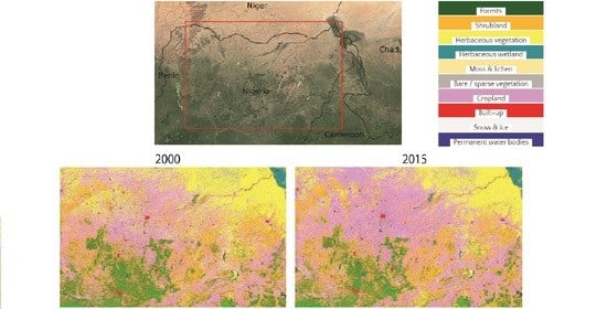
Thirty Years of Land Cover and Fraction Cover Changes over the Sudano-Sahel Using Landsat Time Series

 ,
,  , ,
, ,  , , ,
, , ,  , and
, and Abstract
Share and Cite
Souverijns, N.; Buchhorn, M.; Horion, S.; Fensholt, R.; Verbeeck, H.; Verbesselt, J.; Herold, M.; Tsendbazar, N.-E.; Bernardino, P.N.; Somers, B.; et al. Thirty Years of Land Cover and Fraction Cover Changes over the Sudano-Sahel Using Landsat Time Series. Remote Sens. 2020, 12, 3817. https://doi.org/10.3390/rs12223817
Souverijns N, Buchhorn M, Horion S, Fensholt R, Verbeeck H, Verbesselt J, Herold M, Tsendbazar N-E, Bernardino PN, Somers B, et al. Thirty Years of Land Cover and Fraction Cover Changes over the Sudano-Sahel Using Landsat Time Series. Remote Sensing. 2020; 12(22):3817. https://doi.org/10.3390/rs12223817
Chicago/Turabian StyleSouverijns, Niels, Marcel Buchhorn, Stéphanie Horion, Rasmus Fensholt, Hans Verbeeck, Jan Verbesselt, Martin Herold, Nandin-Erdene Tsendbazar, Paulo N. Bernardino, Ben Somers, and et al. 2020. "Thirty Years of Land Cover and Fraction Cover Changes over the Sudano-Sahel Using Landsat Time Series" Remote Sensing 12, no. 22: 3817. https://doi.org/10.3390/rs12223817
APA StyleSouverijns, N., Buchhorn, M., Horion, S., Fensholt, R., Verbeeck, H., Verbesselt, J., Herold, M., Tsendbazar, N.-E., Bernardino, P. N., Somers, B., & Van De Kerchove, R. (2020). Thirty Years of Land Cover and Fraction Cover Changes over the Sudano-Sahel Using Landsat Time Series. Remote Sensing, 12(22), 3817. https://doi.org/10.3390/rs12223817