Monitoring Urban Green Infrastructure Changes and Impact on Habitat Connectivity Using High-Resolution Satellite Data



Abstract
1. Introduction
2. Materials and Methods
2.1. Study Area and Data Description
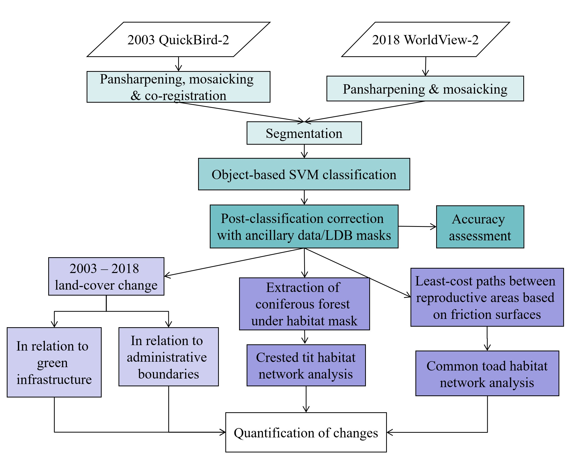
2.2. Methodology
2.2.1. Image Preprocessing
2.2.2. Segmentation and Classification of Satellite Data
2.2.3. Landscape Change Analysis
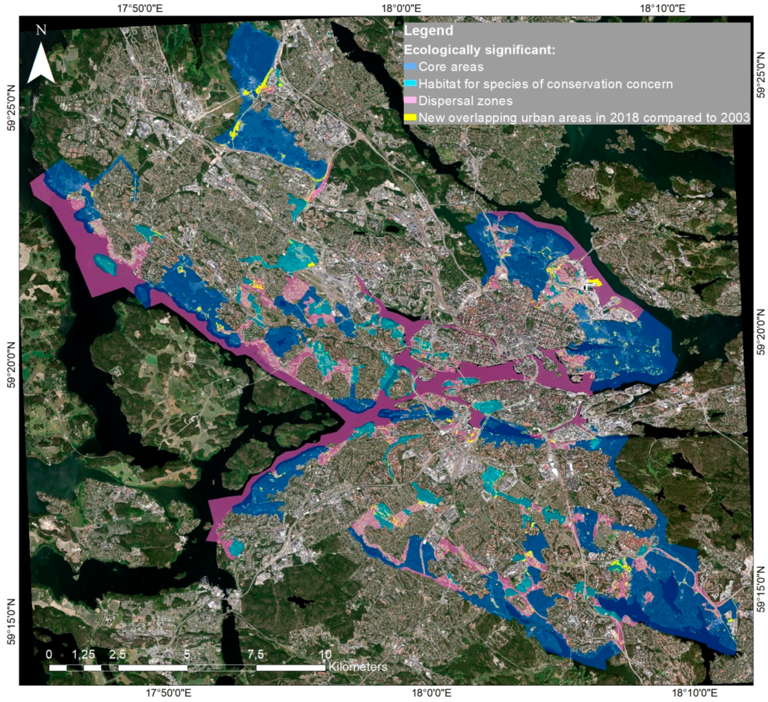
Land-Cover Change According to Administrative Boundaries and Within the Green Infrastructure
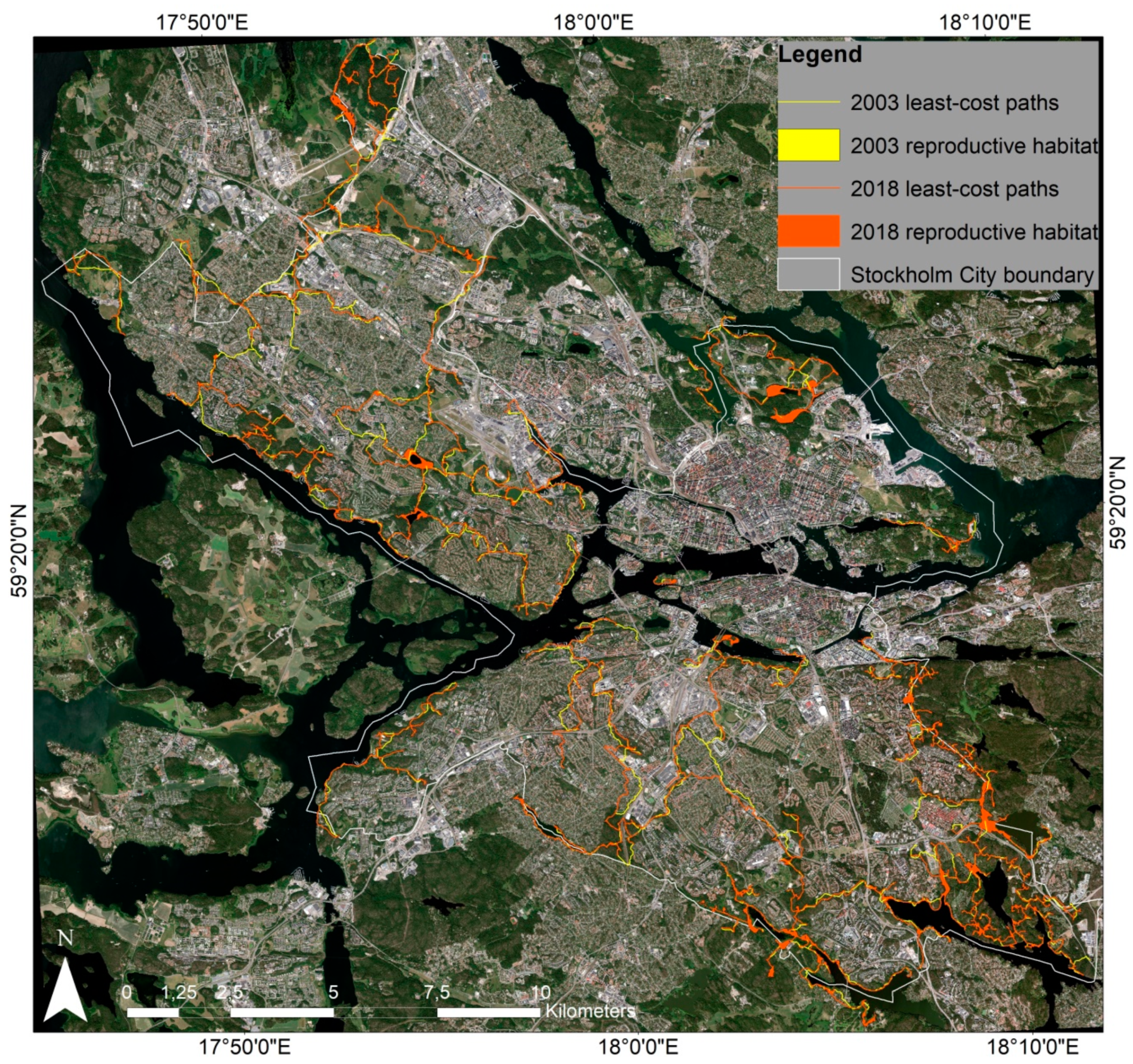
Change in Habitat Network Connectivity
3. Results
3.1. Classification of High-Resolution Satellite Data
3.2. Urban Land-Cover Change and Environmental Impact Analysis
3.2.1. Urban Land-Cover Change at City Level
3.2.2. Land-Cover Change at District Level and within the Green Infrastructure
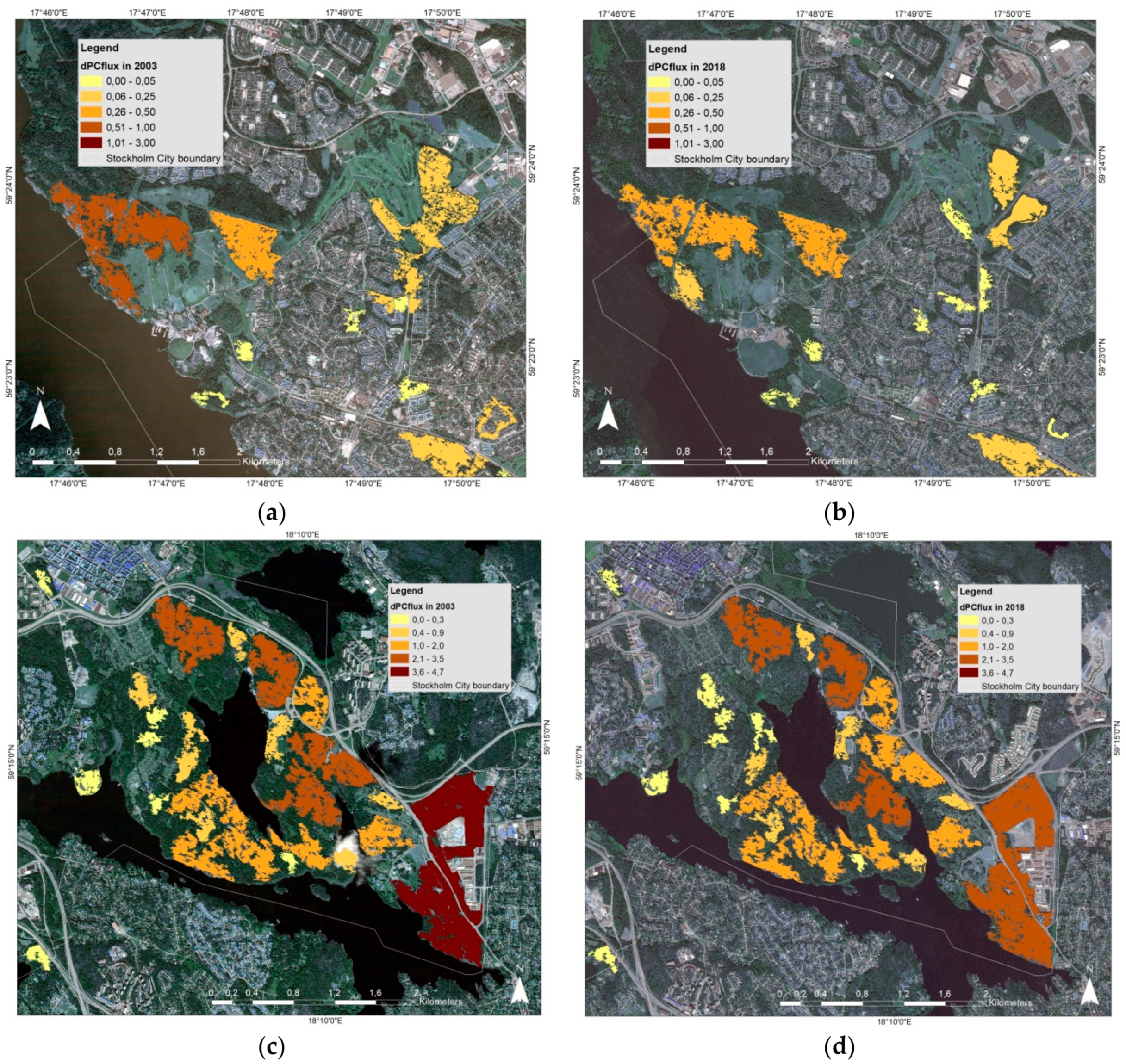
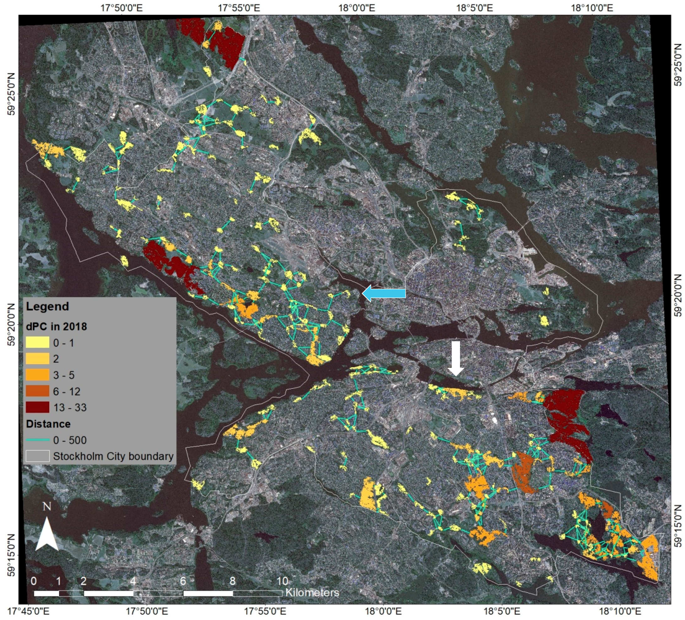
3.2.3. Changes in Habitat Connectivity and Availability
4. Discussion
5. Conclusions
Author Contributions
Funding
Acknowledgments
Conflicts of Interest
Appendix A

| Criteria | Reference | Parameter Used | |
|---|---|---|---|
| Crested Tit | |||
| Habitat preference | Mature and old pine and spruce forests | [77,94] | Land-cover for habitat patches: coniferous forest |
| Nesting areal requirement | Roughly 2–3 ha | [95] | Patch size minimum: 2 ha |
| Dispersal distance | Several kilometers within habitat but reluctant to cross open spaces | [78,79,80] | Assumed median dispersal/movement distance in urban environment: 200 m |
| Common Toad | |||
| Dispersal distance | Up to 2 km over optimal land-cover but only a few meters over unsuitable land-cover (Table A3) | [96,97,98,99] | Assumed maximum dispersal/movement distance in urban environment: 2 km |
| Habitat | Quality | Biotope/Land-Cover |
|---|---|---|
| Reproductive habitat | Optimal | Wetlands, water with vegetation, streams, water-filled ditches |
| Summer habitat | Optimal | Deciduous forest, mixed forest, moist grassland |
| Suboptimal | Low-density built-up areas with trees/bushes, older coniferous forest, managed grassland | |
| Marginal | Low-density built-up areas without vegetation, young coniferous/mixed forest, heavily managed grassland, agricultural areas | |
| Winter habitat | Optimal | Deciduous forest |
| Suboptimal | Mixed forest, grassland with trees/bushes, low-density built-up areas with trees/bushes | |
| Marginal | Coniferous forest |
| Quality for Dispersal | Biotope/Land-Cover |
|---|---|
| Optimal | Deciduous forest, older coniferous/mixed forest, moist grassland |
| Medium | Low-density built-up areas with trees/bushes, young coniferous/mixed forest |
| Unsuitable | Built-up areas with sealed surfaces, including roads, low-density built-up areas without or with heavily managed vegetation, clear-cut areas |
| Barrier | Buildings, sound berms, steep slopes |
References
- Aronson, M.; LaSorte, F.A.; Nilon, C.H.; Katti, M.; Goddard, M.A.; Lepczyk, C.A.; Warren, P.S.; Williams, W.P.S.; Cilliers, S.; Clarkson, B.; et al. A global analysis of the impacts of urbanization on bird and plant diversity reveals key anthropogenic drivers. Proc. Biol. Sci. 2014, 281, 20133330. [Google Scholar] [CrossRef] [Scilit]
- European Commission. Green Infrastructure (GI)—Enhancing Europe’s Natural Capital. Communication COM 249. 2013. Available online: https://eur-lex.europa.eu/legal-content/EN/TXT/?uri=CELEX:52013DC0249 (accessed on 20 July 2020).
- European Commission. EU Biodiversity Strategy for 2030: Bringing Nature Back into Our Lives. Communication COM 380. 2020. Available online: https://eur-lex.europa.eu/resource.html?uri=cellar:a3c806a6-9ab3-11ea-9d2d-01aa75ed71a1.0001.02/DOC_1&format=PDF (accessed on 3 September 2020).
- Swedish Environmental Protection Agency. Regionala Handlingsplaner för Grön Infrastruktur och Prioritering av Naturvårdsinsatser [Regional Action Plans for Green Infrastructure and Priorization of Nature Conservation Efforts]. 2017. Available online: https://www.naturvardsverket.se/upload/stod-i-miljoarbetet/vagledning/samhallsplanering/Vagledning-GI-naturvardsprioriteringar.pdf (accessed on 20 July 2020). (In Swedish)
- Stockholm County Administrative Board. Grön infrastruktur—Regional Handlingsplan för Stockholms län [Green infrastructure—Regional Action Plan for Stockholm County]. Report December 2019. Available online: https://www.lansstyrelsen.se/download/18.35db062616a5352a22a21fa1/1560332365801/R2019-12%20Gr%C3%B6n%20infrastruktur-Handlingsplan.pdf (accessed on 20 July 2020). (In Swedish)
- Tzoulas, K.; Korpela, K.; Venn, S.; Yli-Pelkonen, V.; Kaźmierczak, A.; Niemela, J.; James, P. Promoting ecosystem and human health in urban areas using Green Infrastructure: A literature review. Landsc. Urban Plan. 2007, 81, 167–178. [Google Scholar] [CrossRef] [Scilit]
- Pauleit, S.; Ambrose-Oji, B.; Andersson, E.; Anton, B.; Buijs, A.; Haase, D.; Elands, B.; Hansen, R.; Kowarik, I.; Kronenberg, J.; et al. Advancing urban green infrastructure in Europe: Outcomes and reflections from the GREEN SURGE project. Urban For. Urban Green. 2019, 40, 4–16. [Google Scholar] [CrossRef] [Scilit]
- Mörtberg, U.; Zetterberg, A.; Brokking Balfors, B. Urban landscapes in transition: Lessons from integrating biodiversity and habitat modelling in planning. J. Environ. Assess. Policy Manag. 2012, 14, 1250002. [Google Scholar] [CrossRef] [Scilit]
- Stockholm City. Översiktsplan för Stockholms stad [Comprehensive plan for the City of Stockholm]. 2018. Available online: https://vaxer.stockholm/globalassets/tema/oversiktsplanen/uppdatering-av-op/godkannade-op/oversiktsplan-for-stockholms-stad-godkannandehandling.pdf (accessed on 20 July 2020). (In Swedish)
- Stockholm City. Hållbar mark-och Vattenanvändning [Sustainable Land and Water Use]. 2019. Available online: http://miljobarometern.stockholm.se/miljomal/miljoprogram-2016-2019/hallbar-mark-och-vattenanvandning/ (accessed on 20 July 2020). (In Swedish)
- Stadsbyggnadskontoret Stockholm city building office. In Proceedings of the Communication within EO&AI4ChangeDetection Project Meeting, Stockholm, Sweden, 10 October 2019.
- Herold, M.; Couclelis, H.; Clarke, K.C. The role of spatial metrics in the analysis and modeling of urban land use change. Comput. Environ. Urban Syst. 2005, 29, 369–399. [Google Scholar] [CrossRef] [Scilit]
- Gamba, P.; Herold, M. Global Mapping of Human Settlement: Experiences, Datasets, and Prospects; CRC Press: Boca Raton, FL, USA, 2009. [Google Scholar]
- Furberg, D.; Ban, Y. Satellite monitoring of urban sprawl and assessment of its potential environmental impact in the greater toronto area between 1985 and 2005. Environ. Manag. 2012, 50, 1068–1088. [Google Scholar] [CrossRef] [Scilit]
- Wang, L.; Li, C.; Ying, Q.; Cheng, X.; Wang, X.; Li, X.; Hu, L.; Liang, L.; Yu, L.; Huang, H.; et al. China’s urban expansion from 1990 to 2010 determined with satellite remote sensing. Chin. Sci. Bull. 2012, 57, 2802–2812. [Google Scholar] [CrossRef] [Scilit]
- Liu, T.; Yang, X. Monitoring land changes in an urban area using satellite imagery, GIS and landscape metrics. Appl. Geogr. 2015, 56, 42–54. [Google Scholar] [CrossRef] [Scilit]
- Haas, J.; Ban, Y. Urban land cover and ecosystem service changes based on sentinel-2a msi and landsat tm data. IEEE J. Sel. Top. Appl. Earth Obs. Remote Sens. 2018, 11, 485–497. [Google Scholar] [CrossRef] [Scilit]
- Ban, Y.; Hu, H.; Rangel, I.M. Fusion of Quickbird MS and RADARSAT SAR data for urban land-cover mapping: Object-based and knowledge-based approach. Int. J. Remote Sens. 2010, 31, 1391–1410. [Google Scholar] [CrossRef] [Scilit]
- Myint, S.W.; Gober, P.; Brazel, A.; Grossman-Clarke, S.; Weng, Q. Per-pixel vs. object-based classification of urban land cover extraction using high spatial resolution imagery. Remote Sens. Environ. 2011, 115, 1145–1161. [Google Scholar] [CrossRef] [Scilit]
- Ma, L.; Li, M.; Ma, X.; Cheng, L.; Du, P.; Liu, Y. A review of supervised object-based land-cover image classification. ISPRS J. Photogramm. Remote Sens. 2017, 130, 277–293. [Google Scholar] [CrossRef] [Scilit]
- Momeni, R.; Aplin, P.; Boyd, D.S. Mapping complex urban land cover from spaceborne imagery: The influence of spatial resolution, spectral band set and classification approach. Remote Sens. 2016, 8, 88. [Google Scholar] [CrossRef] [Scilit]
- Shackelford, A.K.; Davis, C.H. A combined fuzzy pixel-based and object-based approach for classification of high-resolution multispectral data over urban areas. IEEE Trans. Geosci. Remote Sens. 2003, 41, 2354–2363. [Google Scholar] [CrossRef] [Scilit]
- Haas, J.; Ban, Y. Mapping and monitoring urban ecosystem services using multitemporal high-resolution satellite data. IEEE J. Sel. Top. Appl. Earth Obs. Remote Sens. 2017, 10, 669–680. [Google Scholar] [CrossRef] [Scilit]
- Mugiraneza, T.; Nascetti, A.; Ban, Y. WorldView-2 data for hierarchical object-based urban land cover classification in kigali: Integrating rule-based approach with urban density and greenness indices. Remote Sens. 2019, 11, 2128. [Google Scholar] [CrossRef] [Scilit]
- Mutuku, F.M.; Bayoh, M.N.; Hightower, A.W.; Vulule, J.M.; Gimnig, J.E.; Mueke, J.M.; Amimo, F.A.; Walker, E.D. A supervised land cover classification of a western Kenya lowland endemic for human malaria: Associations of land cover with larval Anopheles habitats. Int. J. Health Geogr. 2009, 8, 19. [Google Scholar] [CrossRef] [Scilit]
- Recio, M.R.; Mathieu, R.; Hall, G.B.; Moore, A.B.; Seddon, P.J. Landscape resource mapping for wildlife research using very high resolution satellite imagery. Methods Ecol. Evol. 2013, 4, 982–992. [Google Scholar] [CrossRef] [Scilit]
- Sawaya, K.E.; Olmanson, L.G.; Heinert, N.J.; Brezonik, P.L.; Bauer, M.E. Extending satellite remote sensing to local scales: Land and water resource monitoring using high-resolution imagery. Remote Sens. Environ. 2003, 88, 144–156. [Google Scholar] [CrossRef] [Scilit]
- Mathieu, R.; Freeman, C.; Aryal, J. Mapping private gardens in urban areas using object-oriented techniques and very high-resolution satellite imagery. Landsc. Urban Plan. 2007, 81, 179–192. [Google Scholar] [CrossRef] [Scilit]
- Lang, S.; Blaschke, T.; Kothencz, G.; Hölbling, D. Urban green mapping and valuation. In Urban Remote Sensing, 2nd ed.; Weng, Q., Quattrochi, D., Gamba, P.E., Eds.; CRC Press: Boca Raton, FL, USA, 2018; pp. 287–309. [Google Scholar]
- Lakes, T.; Kim, H.O. The urban environmental indicator “Biotope Area Ratio”—an enhanced approach to assess and manage the urban ecosystem services using high resolution remote-sensing. Ecol. Indic. 2012, 13, 93–103. [Google Scholar] [CrossRef] [Scilit]
- Turner, W.; Rondinini, C.; Pettorelli, N.; Mora, B.; Leidner, A.K.; Szantoi, Z.; Buchanan, G.; Dech, S.; Dwyer, J.; Herold, M.; et al. Free and open-access satellite data are key to biodiversity conservation. Biol. Conserv. 2015, 182, 173–176. [Google Scholar] [CrossRef] [Scilit]
- Pettorelli, N.; Laurance, W.F.; O’Brien, T.G.; Wegmann, M.; Nagendra, H.; Turner, W. Satellite remote sensing for applied ecologists: Opportunities and challenges. J. Appl. Ecol. 2014, 51, 839–848. [Google Scholar] [CrossRef] [Scilit]
- Pettorelli, N.; Safi, K.; Turner, W. Satellite remote sensing, biodiversity research and conservation of the future. Philos. Trans. R. Soc. B 2014, 369, 20130190. [Google Scholar] [CrossRef] [Scilit] [PubMed]
- Mairota, P.; Cafarelli, B.; Didham, R.K.; Lovergine, F.P.; Lucas, R.M.; Nagendra, H.; Rocchini, D.; Tarantino, C. Challenges and opportunities in harnessing satellite remote-sensing for biodiversity monitoring. Ecol. Inform. 2015, 30, 207–214. [Google Scholar] [CrossRef] [Scilit]
- Boyle, S.A.; Kennedy, C.M.; Torres, J.; Colman, K.; Pérez-Estigarribia, P.E.; Noé, U. High-resolution satellite imagery is an important yet underutilized resource in conservation biology. PLoS ONE 2014, 9, e86908. [Google Scholar] [CrossRef] [Scilit]
- Nagendra, H.; Lucas, R.; Honrado, J.P.; Jongman, R.H.; Tarantino, C.; Adamo, M.; Mairota, P. Remote sensing for conservation monitoring: Assessing protected areas, habitat extent, habitat condition, species diversity, and threats. Ecol. Indic. 2013, 33, 45–59. [Google Scholar] [CrossRef] [Scilit]
- Löfvenhaft, K.; Runborg, S.; Sjögren-Gulve, P. Biotope patterns and amphibian distribution as assessment tools in urban landscape planning. Landsc. Urban Plan. 2004, 68, 403–427. [Google Scholar] [CrossRef] [Scilit]
- Hartfield, K.A.; Landau, K.I.; Van Leeuwen, W.J. Fusion of high resolution aerial multispectral and LiDAR data: Land cover in the context of urban mosquito habitat. Remote Sens. 2011, 3, 2364–2383. [Google Scholar] [CrossRef] [Scilit]
- Cleve, C.; Kelly, M.; Kearns, F.R.; Moritz, M. Classification of the wildland–urban interface: A comparison of pixel-and object-based classifications using high-resolution aerial photography. Comp. Environ. Urban Syst. 2008, 32, 317–326. [Google Scholar] [CrossRef] [Scilit]
- Agarwal, S.; Vailshery, L.; Jaganmohan, M.; Nagendra, H. Mapping urban tree species using very high resolution satellite imagery: Comparing pixel-based and object-based approaches. ISPRS Int. J. Geo Inf. 2013, 2, 220–236. [Google Scholar] [CrossRef] [Scilit]
- Qian, Y.; Zhou, W.; Yan, J.; Li, W.; Han, L. Comparing machine learning classifiers for object-based land cover classification using very high resolution imagery. Remote Sens. 2015, 7, 153–168. [Google Scholar] [CrossRef] [Scilit]
- Pande-Chhetri, R.; Abd-Elrahman, A.; Liu, T.; Morton, J.; Wilhelm, V.L. Object-based classification of wetland vegetation using very high-resolution unmanned air system imagery. Eur. J. Remote Sens. 2017, 50, 564–576. [Google Scholar] [CrossRef] [Scilit]
- Fahrig, L. Effects of habitat fragmentation on biodiversity. Annu. Rev. Ecol. Evol. Syst. 2003, 34, 487–515. [Google Scholar] [CrossRef] [Scilit]
- St-Laurent, M.-H.; Dussault, C.; Ferron, J.; Gagnon, R. Dissecting habitat loss and fragmentation effects following logging in boreal forest: Conservation perspectives from landscape simulations. Biol. Conserv. 2009, 142, 2240–2249. [Google Scholar] [CrossRef] [Scilit]
- Hanski, I. Metapopulation models. In Encyclopedia of Ecology; Jorgensen, S.E., Fath, B.D., Eds.; Elsevier: Amsterdam, The Netherlands, 2008; pp. 2318–2325. [Google Scholar]
- Urban, D.; Keitt, T. Landscape connectivity: A graph-theoretic perspective. Ecology 2001, 82, 1205–1218. [Google Scholar] [CrossRef]
- Estrada, E.; Bodin, Ö. Using network centrality measures to manage landscape connectivity. Ecol. Appl. 2008, 18, 1810–1825. [Google Scholar] [CrossRef] [Scilit]
- Bodin, Ö.; Zetterberg, A. MatrixGreen: Landscape Ecological Network Analysis Tool–User Manual. Paper V in Connecting the Dots. Doctoral Thesis, KTH Royal Institute of Technology, Stockholm, Sweden, 2011. [Google Scholar]
- Zetterberg, A.; Mörtberg, U.M.; Balfors, B. Making graph theory operational for landscape ecological assessments, planning, and design. Landsc. Urban Plan. 2010, 95, 181–191. [Google Scholar] [CrossRef] [Scilit]
- Saunders, M.I.; Brown, C.J.; Foley, M.M.; Febria, C.M.; Albright, R.; Mehling, M.G.; Kavanaugh, M.T.; Burfeind, D.D. Human impacts on connectivity in marine and freshwater ecosystems assessed using graph theory: A review. Mar. Freshw. Res. 2016, 67, 277–290. [Google Scholar] [CrossRef] [Scilit]
- Huang, Y.; Huang, J.L.; Liao, T.J.; Liang, X.; Tian, H. Simulating urban expansion and its impact on functional connectivity in the Three Gorges Reservoir Area. Sci. Total Environ. 2018, 643, 1553–1561. [Google Scholar] [CrossRef] [Scilit]
- Saura, S.; Pascual-Hortal, L. A new habitat availability index to integrate connectivity in landscape conservation planning: Comparison with existing indices and application to a case study. Landsc. Urban Plan. 2007, 83, 91–103. [Google Scholar] [CrossRef] [Scilit]
- Saura, S.; Rubio, L. A common currency for the different ways in which patches and links can contribute to habitat availability and connectivity in the landscape. Ecography 2010, 33, 523–537. [Google Scholar] [CrossRef] [Scilit]
- Saura, S.; Estreguil, C.; Mouton, C.; Rodríguez-Freire, M. Network analysis to assess landscape connectivity trends: Application to European forests (1990–2000). Ecol. Indic. 2011, 11, 407–416. [Google Scholar] [CrossRef] [Scilit]
- Pérez-Hernández, C.G.; Vergara, P.M.; Saura, S.; Hernández, J. Do corridors promote connectivity for bird-dispersed trees? The case of Persea lingue in Chilean fragmented landscapes. Landsc. Ecol. 2015, 30, 77–90. [Google Scholar] [CrossRef] [Scilit]
- Herrera, L.P.; Sabatino, M.C.; Jaimes, F.R.; Saura, S. Landscape connectivity and the role of small habitat patches as stepping stones: An assessment of the grassland biome in South America. Biodivers. Conserv. 2017, 26, 3465–3479. [Google Scholar] [CrossRef] [Scilit]
- Diniz, M.F.; Machado, R.B.; Bispo, A.A.; Brito, D. Identifying key sites for connecting jaguar populations in the Brazilian Atlantic Forest. Anim. Conserv. 2018, 21, 201–210. [Google Scholar] [CrossRef] [Scilit]
- Bolliger, J.; Silbernagel, J. Contribution of connectivity assessments to Green Infrastructure (GI). ISPRS Int. J. Geo Inf. 2020, 9, 212. [Google Scholar] [CrossRef] [Scilit]
- Zhang, Z.; Meerow, S.; Newell, J.P.; Lindquist, M. Enhancing landscape connectivity through multifunctional green infrastructure corridor modeling and design. Urban For. Urban Green. 2019, 38, 305–317. [Google Scholar] [CrossRef] [Scilit]
- Perkl, R.; Norman, L.M.; Mitchell, D.; Feller, M.; Smith, G.; Wilson, N.R. Urban growth and landscape connectivity threats assessment at Saguaro National Park, Arizona, USA. J. Land Use Sci. 2018, 13, 102–117. [Google Scholar] [CrossRef] [Scilit]
- Nor, A.N.M.; Corstanje, R.; Harris, J.A.; Grafius, D.R.; Siriwardena, G.M. Ecological connectivity networks in rapidly expanding cities. Heliyon 2017, 3, e00325. [Google Scholar] [CrossRef] [Scilit]
- Stockholm City. Statistical Year-Book of Stockholm 2018; Stockholm City: Stockholm, Sweden, 2018. Available online: https://start.stockholm/globalassets/start/om-stockholms-stad/utredningar-statistik-och-fakta/statistik/arsbok/arsbok_2018.pdf (accessed on 20 July 2020).
- Growth and Regional Planning Administration—GRPA (Tillväxt- och Regionplaneförvaltningen). Regional utvecklingsplan för Stockholmsregionen RUFS 2050 [Regional Development Plan for the Stockholm Region RUFS 2050]. Stockholm County Council. 2018. Available online: http://rufs.se/globalassets/e.-rufs-2050/rufs_regional_utvecklingsplan_for_stockholmsregionen_2050_tillganglig.pdf (accessed on 20 July 2020). (In Swedish)
- Stockholm City Environmental Management Department (Miljöförvaltningen, Stockholms stad). Stockholms Ekologiska Infrastruktur—Bakgrund och Beskrivning av Databas och Karta. [Stockholm’s ecological infrastructure—Background and description of the database and map.]. Version 14 February 2014. Available online: http://miljobarometern.stockholm.se/content/docs/mp15/4/ESBO_Bed%C3%B6mningsgrunder.pdf (accessed on 20 July 2020). (In Swedish)
- Gothnier, M.; Hjorth, G.; Östergård, S. Rapport från ArtArken [Report from the Species Ark]. Stockholms artdata-arkiv. Miljöförvaltningen: Stockholm, Sweden, 1999. Available online: http://miljobarometern.stockholm.se/content/docs/tema/natur/Rapport%20fr%C3%A5n%20ArtArken1999%20publ.pdf (accessed on 20 July 2020). (In Swedish)
- Mörtberg, U.; Zetterberg, A.; Gontier, M. Landskapsekologisk analys i Stockholms stad: Metodutveckling med groddjur som exempel [Landscape Ecological Analysis i Stockholm City: Method Development with Amphibians as an Example]; Miljöförvaltningen: Stockholm, Sweden, 2006; Available online: http://miljobarometern.stockholm.se/content/docs/tema/natur/Habitatverktyg_groddjur_2008.pdf (accessed on 20 July 2020). (In Swedish)
- Mörtberg, U.; Zetterberg, A.; Gontier, M. Landskapsekologisk Analys i Stockholms stad: Habitatnätverk för Eklevande Arter och Barrskogsarter [Landscape Ecological Analysis i Stockholm City: Habitat Networks for Oak-Dependent Species and Coniferous Forest Species]; Miljöförvaltningen: Stockholm, Sweden, 2007. Available online: http://miljobarometern.stockholm.se/content/docs/tema/natur/Habitatverktyg_ek_barrskogsarter_2008.pdf (accessed on 20 July 2020). (In Swedish)
- Zhang, Y. 2008. Pan-sharpening for improved information extraction. In Advances in Photogrammetry, Remote Sensing and Spatial Information Sciences; Li, Z., Chen, J., Baltsavias, E., Eds.; CRC Press: Boca Raton, FL, USA, 2008; Volume 7, Chapter 14; pp. 185–203. [Google Scholar]
- Zhang, Y. Problems in the fusion of commercial high-resolution satellite as well as Landsat 7 images and initial solutions. Int. Arch. Photogramm. Remote Sens. Spat. Inf. Sci. 2002, 34, 587–592. [Google Scholar]
- DigitalGlobe. QuickBird Datasheet. 2014. Available online: https://dgv4-cms-production.s3.amazonaws.com/uploads/document/file/131/QuickBird-DS-QB-Prod.pdf (accessed on 20 July 2020).
- DigitalGlobe. WorldView-2 Datasheet. 2016. Available online: https://dgv4-cms-production.s3.amazonaws.com/uploads/document/file/130/WorldView2-DS-WV2-rev2.pdf (accessed on 20 July 2020).
- Blaschke, T. Object based image analysis for remote sensing. ISPRS J. Photogramm. Remote Sens. 2010, 65, 2–16. [Google Scholar] [CrossRef] [Scilit]
- Chen, G.; Weng, Q. Special issue: Remote sensing of our changing landscapes with Geographic Object-based Image Analysis (GEOBIA). GISci. Remote Sens. 2018, 55, 155–158. [Google Scholar] [CrossRef] [Scilit]
- Trimble Germany GmbH. eCognition Developer 9.2 Reference Book; Document Version 9.2.1; Trimble Germany GmbH: Munich, Germany, 2016. [Google Scholar]
- Swedish Environmental Protection Agency. Nationella marktäckedata 2018 basskikt: Produktbeskrivning [National Land-Cover Data 2018 Basic Layer: Product Description]. Version 2.2; 7 July 2020. Available online: https://gpt.vic-metria.nu/data/land/NMD/NMD_Produktbeskrivning_NMD2018Basskikt_v2_2.pdf (accessed on 20 July 2020). (In Swedish)
- Furberg, D.; Ban, Y.; Nascetti, A. Monitoring of urbanization and analysis of environmental impact in Stockholm with Sentinel-2A and SPOT-5 multispectral data. Remote Sens. 2019, 11, 2408. [Google Scholar] [CrossRef] [Scilit]
- Ulfstrand, S. Foraging niche dynamics and overlap in a guild of passerine birds in a south swedish coniferous woodland. Oecologia 1977, 27, 23–45. [Google Scholar] [CrossRef] [Scilit] [PubMed]
- Alatalo, R.V.; Eriksson, D.; Gustafsson, L.; Larsson, K. Exploitation competition influences the use of foraging sites by tits: Experimental evidence. Ecology 1987, 68, 284–290. [Google Scholar] [CrossRef] [Scilit]
- Hansson, L. Vertebrate distributions relative to clear-cut edges in a boreal forest landscape. Landsc. Ecol. 1994, 9, 105–115. [Google Scholar]
- Rodriguez, A.; Andrén, H.; Jansson, G. Habitat-mediated predation risk and decision making of small birds at forest edges. OIKOS 2001, 95, 383–396. [Google Scholar] [CrossRef] [Scilit]
- Groddjur [Amphibians]. Available online: http://miljobarometern.stockholm.se/natur/arter-och-artgrupper/groddjur/groddjur/ (accessed on 16 July 2020). (In Swedish)
- Grodkollen—grodperspektiv på Stockholms natur [Amphibianwatch—Amphibian Perspectives on Stockholm’s Nature]. Available online: http://grodkollen.se/projekt/ (accessed on 16 July 2020). (In Swedish)
- Saura, S.; Torne, J. Conefor Sensinode 2.2: A software package for quantifying the importance of habitat patches for landscape connectivity. Environ. Modell. Softw. 2009, 24, 135–139. [Google Scholar] [CrossRef] [Scilit]
- Hanski, I.; Ovaskainen, O. The metapopulation capacity of a fragmented landscape. Nature 2000, 404, 755–758. [Google Scholar] [CrossRef] [Scilit]
- Moilanen, A.; Nieminen, M. Simple connectivity measures in spatial ecology. Ecology 2002, 83, 1131–1145. [Google Scholar] [CrossRef]
- Jenness Enterprises. Conefor Inputs, Build 1.0.218. 9 April 2016. Available online: http://www.jennessent.com/arcgis/conefor_inputs.htm (accessed on 20 July 2020).
- Liu, S.; Su, H.; Cao, G.; Wang, S.; Guan, Q. Learning from data: A post classification method for annual land cover analysis in urban areas. ISPRS J. Photogramm. Remote Sens. 2019, 154, 202–215. [Google Scholar] [CrossRef] [Scilit]
- European Commission. EU Guidance on Integrating Ecosystems and their Services into Decision-Making. SWD (2019) 305 final; European Commission: Brussels, Belgium, 2019; Available online: https://ec.europa.eu/environment/nature/ecosystems/pdf/SWD_2019_305_F1_STAFF_WORKING_PAPER_EN_V2_P1_1042629.PDF (accessed on 1 September 2020).
- City of Stockholm. Proposed Program for Monitoring Biodiversity and Related Ecosystem Services 2017–2021; Dnr: 2016–16202; Stockholm City Environmental Management Department (Miljöförvaltningen, Stockholms stad): Stockholms, Sweden, 2017. Available online: https://insynsverige.se/documentHandler.ashx?did=1864151 (accessed on 3 September 2020). (In Swedish)
- Wellmann, T.; Lausch, A.; Andersson, E.; Knapp, S.; Cortinovis, C.; Jache, J.; Scheuer, S.; Kremer, P.; Mascarenhas, A.; Kraemer, R.; et al. Remote sensing in urban planning: Contributions towards ecologically sound policies? Landsc. Urban Plan. 2020, 204, 103921. [Google Scholar] [CrossRef] [Scilit]
- Kopecká, M.; Szatmári, D.; Rosina, K. Analysis of urban green spaces based on sentinel-2A: Case studies from slovakia. Land 2017, 6, 25. [Google Scholar] [CrossRef] [Scilit]
- Nichol, J.; Lee, C.M. Urban vegetation monitoring in Hong Kong using high resolution multispectral images. Int. J. Remote Sens. 2005, 26, 903–918. [Google Scholar] [CrossRef] [Scilit]
- Tigges, J.; Lakes, T.; Hostert, P. Urban vegetation classification: Benefits of multitemporal RapidEye satellite data. Remote Sens. Environ. 2013, 136, 66–75. [Google Scholar] [CrossRef] [Scilit]
- Alatalo, R.V.; Gustafsson, L.; Linden, M.; Lundberg, A. Interspecific competition and niche shifts in tits and the goldcrest: An experiment. J. Anim. Ecol. 1985, 54, 977–984. [Google Scholar] [CrossRef] [Scilit]
- Eggers, S. Personal Communication with U. Mörtberg; Swedish University of Agricultural Sciences: Uppsala, Sweden, 2006. [Google Scholar]
- Reading, C.J.; Loman, J.; Madsen, T. Breeding pond fidelity in the common toad, Bufo bufo. J. Zool. 1991, 225, 201–211. [Google Scholar] [CrossRef] [Scilit]
- Andrén, C. Personal Communication with U. Mörtberg; University of Gothenburg: Gothenburg, Sweden, 2005. [Google Scholar]
- Loman, J. Personal Communication with U. Mörtberg; University of Lund: Lund, Sweden, 2005. [Google Scholar]
- Sjögren-Gulve, P. Personal Communication with U. Mörtberg; Swedish Environmental Protection Agency: Stockholm, Sweden, 2005.


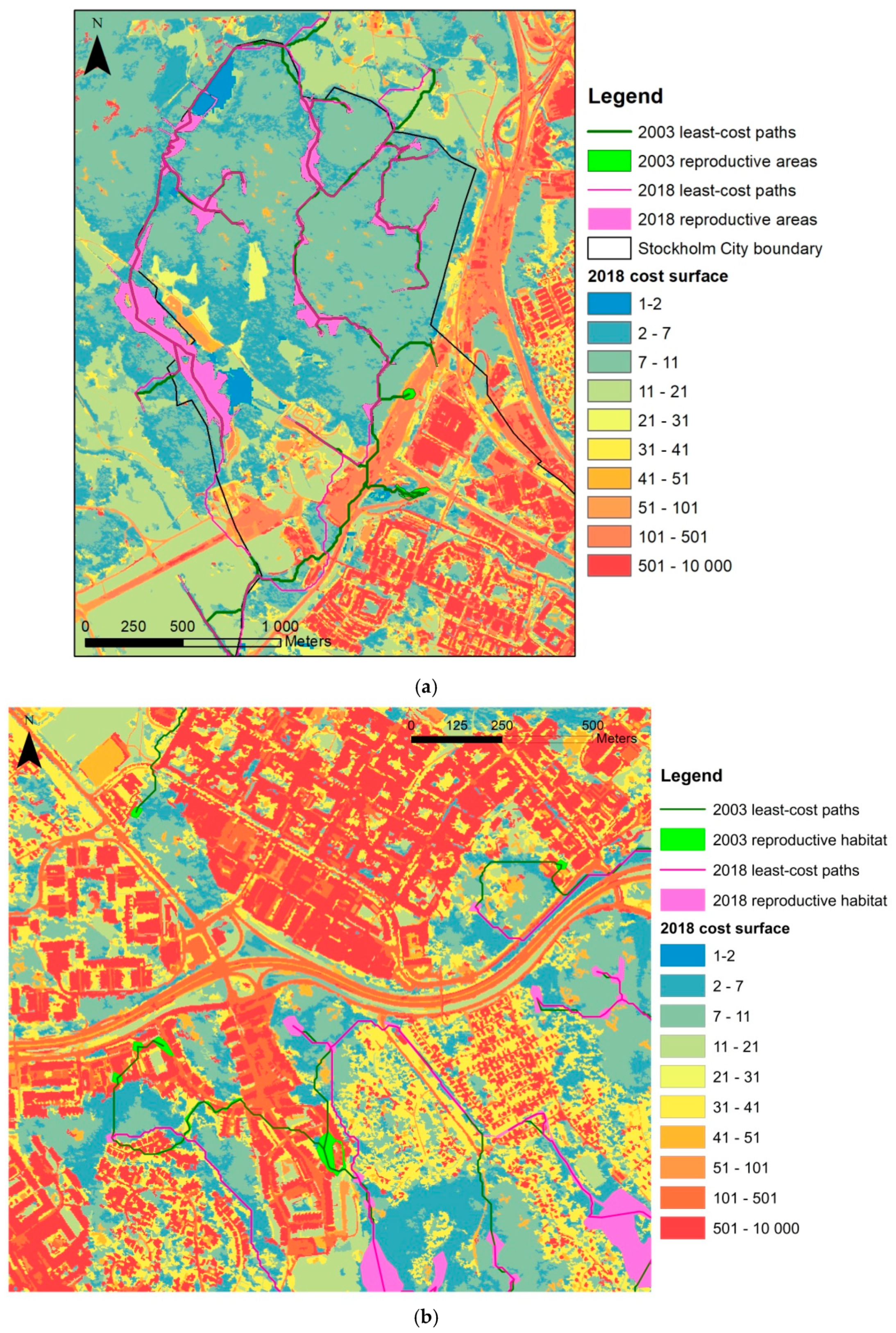
| 2006 | 2003 and 2018 | |
|---|---|---|
| Buildings | 10000 (building edge), 100 (interior) | 10000 |
| Transport/construction (roads) | 50, 100, 200, 10000 | 500 |
| Barren land | 90 | 100 |
| Bare rock | 50 | 50 |
| Urban green space | 30, 40, 50 | 40 |
| Agriculture | 25 | 30 |
| Grassland | 15, 25 | 20 |
| Coniferous forest | 10, 20 | 10 |
| Deciduous forest | 5 | 5 |
| Wetlands | 10, 20, 40 | 1 |
| Water | 0–150 m from shore friction gradient that increases exponentially with increased distance, from 1 to 10000 | |
| 2003 QuickBird-2 | 2018 WorldView-2 | |||
|---|---|---|---|---|
| PA | UA | PA | UA | |
| Buildings | 94.8 | 83.4 | 95.4 | 84.4 |
| Transport/Construction | 85.6 | 85.3 | 87.1 | 88.6 |
| Barren Land | 82.3 | 97.4 | 86.0 | 97.9 |
| Grassland/Sports Fields | 98.8 | 96.1 | 89.7 | 92.0 |
| Urban Green Space | 90.1 | 92.5 | 88.4 | 88.7 |
| Coniferous Forest | 98.8 | 92.6 | 96.6 | 86.5 |
| Deciduous Forest | 95.0 | 97.0 | 88.1 | 94.2 |
| Water | 99.8 | 100.0 | 99.1 | 99.7 |
| Bare Rock | 91.3 | 98.0 | 91.1 | 95.1 |
| Overall Accuracy: | 93.0% | 91.5% | ||
| Overall Kappa Statistic: | 0.92 | 0.90 | ||
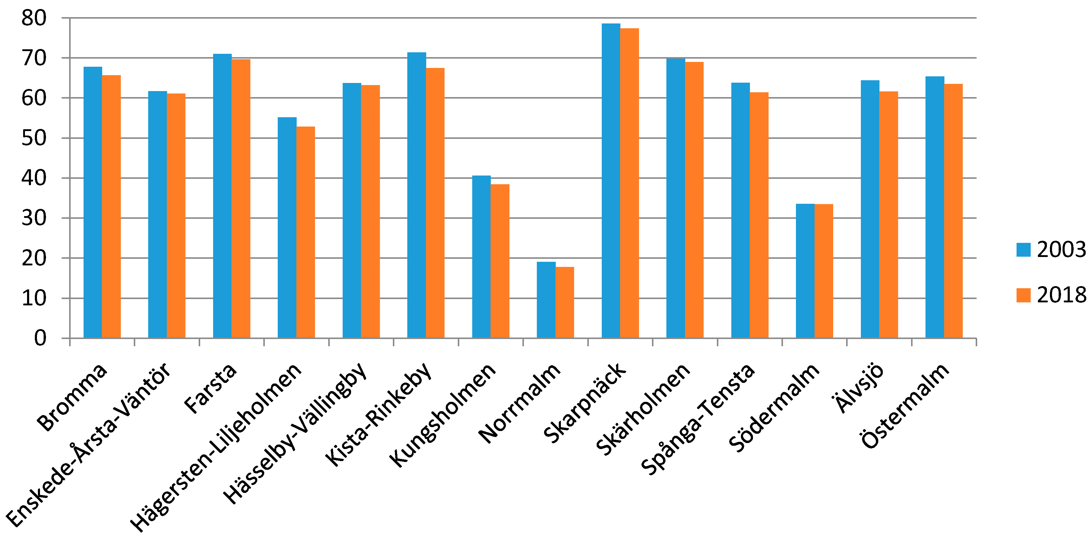
| City District | Urban Growth in Hectares | City District | Percentage Loss of Green Area |
|---|---|---|---|
| Bromma | 53.9 | Kista-Rinkeby | −3.95 |
| Kista-Rinkeby | 47.1 | Älvsjö | −2.76 |
| Östermalm | 39.0 | Spånga-Tensta | −2.40 |
| Spånga-Tensta | 31.1 | Hägersten-Liljeholmen | −2.34 |
| Hägersten-Liljeholmen | 30.8 | Kungsholmen | −2.16 |
| Farsta | 26.6 | Bromma | −1.40 |
| Älvsjö | 25.4 | Östermalm | −1.85 |
| Skarpnäck | 19.6 | Farsta | −1.40 |
| Enskede-Årsta-Vantör | 13.8 | Norrmalm | −1.23 |
| Kungsholmen | 12.0 | Skarpnäck | −1.21 |
| Hässelby-Vällingby | 10.1 | Hässelby-Vällingby | −0.56 |
| Norrmalm | 7.6 | Skärholmen | −0.79 |
| Skärholmen | 7.3 | Enskede-Årsta-Vantör | −0.63 |
| Södermalm | 3.1 | Södermalm | −0.10 |
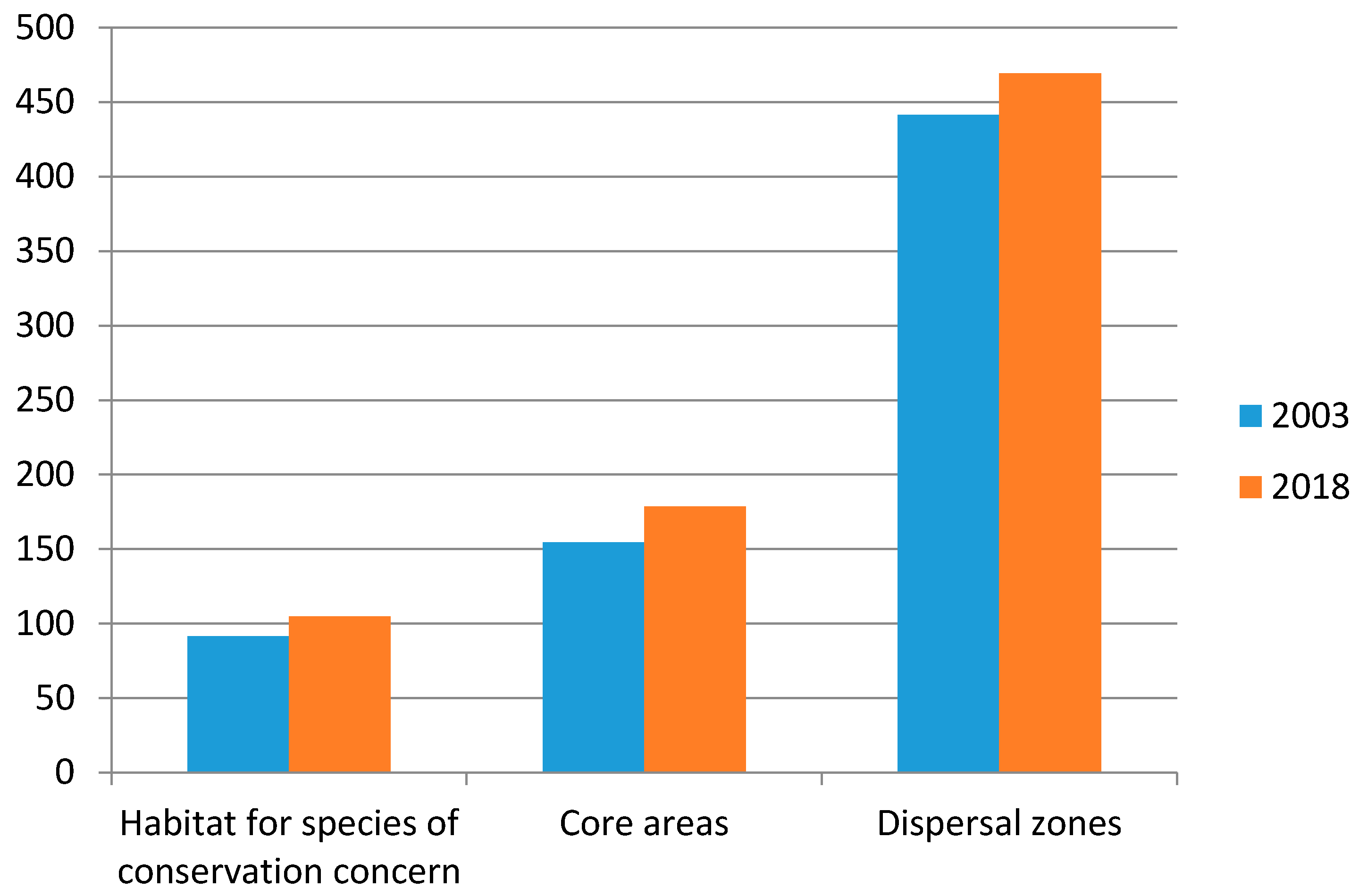
| Green Infrastructure Type | Hectares Converted | Urban Area Increase (%) |
|---|---|---|
| Habitat for Species of Conservation Concern | 13 | 14 |
| Core Areas | 18 | 11 |
| Dispersal Zones | 28 | 6 |
| Year | PC | ECA (ha) | dA | dECA |
|---|---|---|---|---|
| 2003 | 0.06% | 530 | –3% | –4% |
| 2018 | 0.05% | 508 |
| Year | PC | ECA (ha) | dA | dECA |
|---|---|---|---|---|
| 2003 | 0.00042% | 44.3 | −1.6% | −0.03% |
| 2018 | 0.00042% | 44.1 |
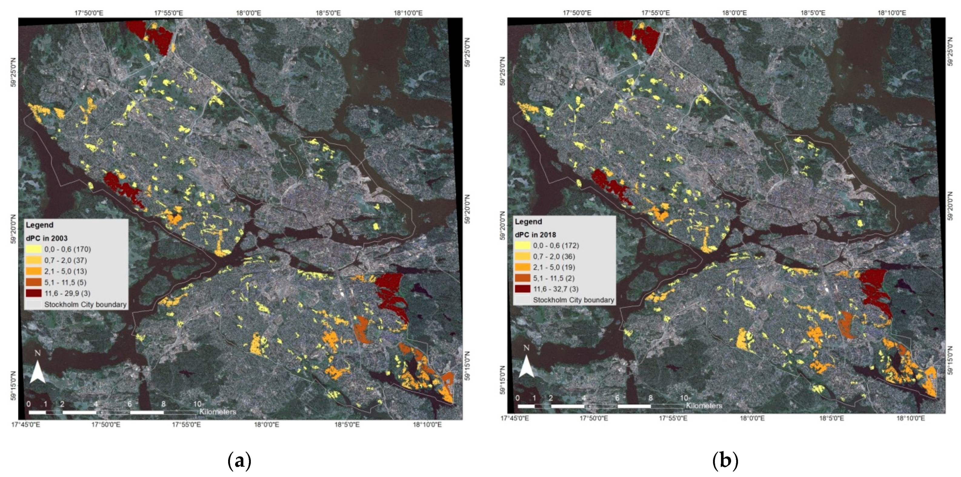
| dPCintra | dPCflux | dPCconnector | |
|---|---|---|---|
| (a) | |||
| 2003 | 26% | 50% | 24% |
| 2018 | 28% | 49% | 23% |
| Difference | 2.2% | −0.9% | −1.3% |
| (b) | |||
| 2003 | 92.2% | 7.6% | 0.16% |
| 2018 | 93.0% | 6.8% | 0.18% |
| Difference | 0.8% | −0.9% | 0.02% |
© 2020 by the authors. Licensee MDPI, Basel, Switzerland. This article is an open access article distributed under the terms and conditions of the Creative Commons Attribution (CC BY) license (http://creativecommons.org/licenses/by/4.0/).
Share and Cite
Furberg, D.; Ban, Y.; Mörtberg, U. Monitoring Urban Green Infrastructure Changes and Impact on Habitat Connectivity Using High-Resolution Satellite Data. Remote Sens. 2020, 12, 3072. https://doi.org/10.3390/rs12183072
Furberg D, Ban Y, Mörtberg U. Monitoring Urban Green Infrastructure Changes and Impact on Habitat Connectivity Using High-Resolution Satellite Data. Remote Sensing. 2020; 12(18):3072. https://doi.org/10.3390/rs12183072
Chicago/Turabian StyleFurberg, Dorothy, Yifang Ban, and Ulla Mörtberg. 2020. "Monitoring Urban Green Infrastructure Changes and Impact on Habitat Connectivity Using High-Resolution Satellite Data" Remote Sensing 12, no. 18: 3072. https://doi.org/10.3390/rs12183072
APA StyleFurberg, D., Ban, Y., & Mörtberg, U. (2020). Monitoring Urban Green Infrastructure Changes and Impact on Habitat Connectivity Using High-Resolution Satellite Data. Remote Sensing, 12(18), 3072. https://doi.org/10.3390/rs12183072