Socio-Economic Impacts of Pluvial Floods in the Metropolitan Area of Barcelona in a Climate Change Context


Abstract
1. Introduction
2. Materials and Methods
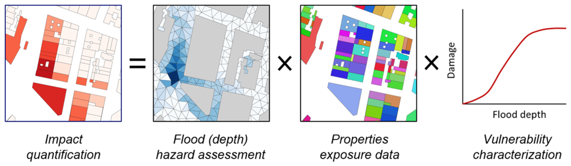
- Hazard: time-space distribution of the severity of an event characterized by an assigned probability of occurrence in a location and timeframe.
- Exposure: distribution of risk receptors occupying a specific location and time in the area affected by the modeled hazard.
- Vulnerability: the susceptibility of exposed risk receptors to be damaged by the modeled hazard types and their intensities.
2.1. Data Collection and Preprocessing
2.2. Hazard Flood Model Setup
2.3. Hazard Assessment Scenarios
2.3.1. Single-Hazard Scenario Simulation
2.3.2. Multi-Hazard Scenario
2.3.3. Adaptation Scenario
- Porous pavements: This implementation level was based on the AMB policy to prioritize permeable surfaces in specific road categories. The region has 9084 km of paved streets, of which 2930 km are designated as “Zone 30” (slow-speed single-lane streets) and 331 km host bike lanes. Applying a standard width of 1.5 m to these priority areas results in approximately 58.1 km2 of potential implementation, which corresponds to 9% of the total street area in the metropolitan region. The realism of this measure is further supported by experimental evidence from pilots and laboratory tests at the Technical University of Catalonia, which demonstrate that these pavements can virtually eliminate runoff for the rainfall intensities simulated in this study [62,63].
- Green roofs: These have been increasingly promoted in several cities in the AMB [61]. A conservative scenario was adopted in which 10% of the 7500 public buildings in the AMB (19 km2 in total) were assumed to be fully covered by green roofs. This assumption is aligned with the guidelines in the Barcelona Nature Plan 2030 [64,65] and the targets set by the Municipal Urban Ecology Agency. The 10% threshold is justified by local feasibility studies and the city’s strategy to reach 22,000 m2 of green roofs by 2030 [64,66,67]. In the model, these roofs are assigned an initial loss of 7 mm (up from 3 mm) and a Manning roughness of 0.4 (up from 0.015) to simulate both runoff reduction and peak flow attenuation [61,67].
- Bioretention areas: The Urban Drainage Master Plan of Barcelona identified green inner patios as strategic areas for distributed infiltration and runoff reduction [61]. A regional assessment estimated that 7.3 km2 of these spaces could potentially be converted into bioretention areas, resulting in a 12% reduction in total effective roof area at the metropolitan scale. The dimensions and efficacy of such measures are supported by regional studies [65].
2.4. Impact Assessment Methods
2.4.1. Economic Impact on Buildings
- The hazard characterization for each building was based on the average flood depth in its surrounding area.
- The exposure assessment consisted of cadastral information (obtained from the Spanish Cadastre) indicating: (1) building location; (2) type of activity, classified into 14 categories; and (3) total ground floor and basement area.
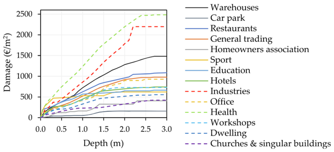
- The vulnerability was characterized by the mentioned depth–damage functions, which were particularized for 14 cadastral types (see Figure 6).
2.4.2. Risk Assessment for Pedestrians
2.4.3. Risk Assessment on Vehicles
2.5. Scenario Comparison
3. Results
3.1. Economic Impact on Buildings Resutls
3.2. Risk for Pedestrians Resutls
3.3. Risk to Vehicles Resutls
4. Discussion
5. Conclusions
Author Contributions
Funding
Institutional Review Board Statement
Informed Consent Statement
Data Availability Statement
Acknowledgments
Conflicts of Interest
References
- IPCC. Climate Change 2022—Impacts, Adaptation and Vulnerability: Working Group II Contribution to the Sixth Assessment Report of the Intergovernmental Panel on Climate Change, 1st ed.; Cambridge University Press: Cambridge, UK, 2023. [Google Scholar]
- Dodman, D.; Hayward, B.; Pelling, M.; Castan Broto, V.; Chow, W.; Chu, E.; Dawson, R.; Khirfan, L.; McPhearson, A.; Prakash, A.; et al. Cities, Settlements and Key Infrastructure. In Climate Change 2022: Impacts, Adaptation and Vulnerability. Contribution of Working Group II to the Sixth Assessment Report of the Intergovernmental Panel on Climate Change; IPCC: Geneva, Switzerland, 2022. [Google Scholar]
- EEA. European Climate Risk Assessment; European Environmental Agency: Copenhagen, Demnark, 2024. [Google Scholar]
- UN DESA. World Urbanization Prospects: The 2018 Revision; United Nations, Department of Economic and Social Affairs, Population Division: New York, NY, USA, 2019. [Google Scholar]
- Hallegatte, S.; Green, C.; Nicholls, R.J.; Corfee-Morlot, J. Future Flood Losses in Major Coastal Cities. Nat. Clim. Change 2013, 3, 802–806. [Google Scholar] [CrossRef] [Scilit]
- Jongman, B.; Ward, P.J.; Aerts, J.C.J.H. Global Exposure to River and Coastal Flooding: Long Term Trends and Changes. Glob. Environ. Change 2012, 22, 823–835. [Google Scholar] [CrossRef] [Scilit]
- Pakati, S.S.; Shoko, C.; Dube, T. Integrated Flood Modelling and Risk Assessment in Urban Areas: A Review on Applications, Strengths, Limitations and Future Research Directions. J. Hydrol. Reg. Stud. 2025, 61, 102583. [Google Scholar] [CrossRef] [Scilit]
- Romali, N.S.; Sulong, S.; Kawasaki, A. A Systematic Review of Flood Damage Assessment: Insight for the Data-Scarce Regions. Water Resour. Manag. 2025, 39, 4707–4734. [Google Scholar] [CrossRef] [Scilit]
- Fornino, M. A Multi-Country Study of Forward-Looking Economic Losses from Floods and Tropical Cyclones; IMF Working Papers; International Monetary Fund: Washington, DC, USA, 2024; Volume 2024, 45p. [Google Scholar] [CrossRef] [Scilit]
- Fox, S.; Agyemang, F.; Hawker, L.; Neal, J. Integrating Social Vulnerability into High-Resolution Global Flood Risk Mapping. Nat. Commun. 2024, 15, 3155. [Google Scholar] [CrossRef] [Scilit]
- Allaire, M. Socio-Economic Impacts of Flooding: A Review of the Empirical Literature. Water Secur. 2018, 3, 18–26. [Google Scholar] [CrossRef] [Scilit]
- Ghosh, M.; Ghosh, S.; Karmakar, S. Assessment of Flood Risk in a Coastal City Considering Multiple Socio-Economic Vulnerability Scenarios. In Proceedings of IAHS; Copernicus GmbH: Göttingen, Germany, 2024; Volume 386, pp. 299–306. [Google Scholar]
- CLIMATE Adapt Population Characteristics in Potential Flood-Prone Areas. Available online: https://climate-adapt.eea.europa.eu/en/observatory/publications-data/analysis-data/exposure-to-potential-flood-prone-areas (accessed on 16 March 2026).
- EEA Floods in Europe. Available online: https://discomap.eea.europa.eu/ClimatePreparedness2025/?page=Floods (accessed on 16 March 2026).
- EEA. Responding to Climate Change Impacts on Human Health in Europe: Focus on Floods, Droughts and Water Quality; European Environment Agency Publications Office: Luxembourg, 2024. [Google Scholar]
- EEA. Economic Losses and Fatalities from Weather- and Climate-Related Events in Europe (Briefing No. 21/2021); European Environmental Agency: Copenhagen, Denmark, 2021. [Google Scholar]
- EEA. Urban Adaptation in Europe: How Cities and Towns Respond to Climate Change (Report No. 12/2020); European Environmental Agency: Copenhagen, Denmark, 2020. [Google Scholar]
- Pastor-Escuredo, D.; Torres, Y.; Martínez-Torres, M.; Zufiria, P.J. Rapid Multi-Dimensional Impact Assessment of Floods. Sustainability 2020, 12, 4246. [Google Scholar] [CrossRef] [Scilit]
- Hammond, M.J.; Chen, A.S.; Djordjević, S.; Butler, D.; Mark, O. Urban flood impact assessment: A state-of-the-art review. Urban Water J. 2015, 14, 14–26. [Google Scholar] [CrossRef] [Scilit]
- Sañudo, E.; García-Feal, O.; Hagen, L.; Cea, L.; Puertas, J.; Montalvo, C.; Alvarado-Vicencio, R.; Hofmann, J. IberSWMM+: A High-Performance Computing Solver for 2D-1D Pluvial Flood Modelling in Urban Environments. J. Hydrol. 2025, 651, 132603. [Google Scholar] [CrossRef] [Scilit]
- Leandro, J.; Chen, A.S.; Djordjević, S.; Savić, D.A. Comparison of 1D/1D and 1D/2D Coupled (Sewer/Surface) Hydraulic Models for Urban Flood Simulation. J. Hydraul. Eng. 2009, 135, 495–504. [Google Scholar] [CrossRef] [Scilit]
- De Saint-Venant, A.J.C.B. Théorie Du Mouvement Non Permanent Des Eaux, Avec Application Aux Crues Des Rivières et à l’introduction Des Marées Dans Leur Lit. In Comptes Rendus Hebdomadaires des Séances de l’Académie des Sciences; Gauthier-Villars: Paris, France, 1871. [Google Scholar]
- Chaudhry, M.H. Open-Channel Flow; Springer International Publishing: Cham, Switzerland, 2022. [Google Scholar]
- Cea, L.; Costabile, P. Flood Risk in Urban Areas: Modelling, Management and Adaptation to Climate Change. A Review. Hydrology 2022, 9, 50. [Google Scholar] [CrossRef] [Scilit]
- Russo, B.; Velasco, M.; Locatelli, L.; Sunyer, D.; Yubero, D.; Monjo, R.; Martínez-Gomariz, E.; Forero-Ortiz, E.; Sánchez-Muñoz, D.; Evans, B.; et al. Assessment of Urban Flood Resilience in Barcelona for Current and Future Scenarios. The RESCCUE Project. Sustainability 2020, 12, 5638. [Google Scholar] [CrossRef] [Scilit]
- Martínez-Gomariz, E.; Locatelli, L.; Guerrero, M.; Russo, B.; Martínez, M. Socio-Economic Potential Impacts Due to Urban Pluvial Floods in Badalona (Spain) in a Context of Climate Change. Water 2019, 11, 2658. [Google Scholar] [CrossRef] [Scilit]
- Lou, Y.; Wang, P.; Li, Y.; Zhang, Y.; Xie, B.; Hu, T. Projecting Urban Flood Risk through Hydrodynamic Modeling under Shared Socioeconomic Pathways. J. Environ. Manag. 2024, 370, 122647. [Google Scholar] [CrossRef] [Scilit] [PubMed]
- Wang, M.; Fu, X.; Zhang, D.; Chen, F.; Liu, M.; Zhou, S.; Su, J.; Tan, S.K. Assessing Urban Flooding Risk in Response to Climate Change and Urbanization Based on Shared Socio-Economic Pathways. Sci. Total Environ. 2023, 880, 163470. [Google Scholar] [CrossRef] [Scilit] [PubMed]
- Bachofer, F.; Wang, Z.; Huth, J.; Eisfelder, C.; Reimuth, A.; Kuenzer, C. Urban Growth Prediction along Shared Socioeconomic Pathways (SSPs) for Future Flood Exposure Risk Assessment: A Cross-Continental Analysis of Coastal Cities. Anthr. Coasts 2026, 9, 1. [Google Scholar] [CrossRef] [Scilit]
- Yan, L.; Rong, H.; Yang, W.; Lin, J.; Zheng, C. A Novel Integrated Urban Flood Risk Assessment Approach Based on One-Two Dimensional Coupled Hydrodynamic Model and Improved Projection Pursuit Method. J. Environ. Manag. 2024, 366, 121910. [Google Scholar] [CrossRef] [Scilit]
- Noh, S.J.; Lee, J.-H.; Lee, S.; Kawaike, K.; Seo, D.-J. Hyper-Resolution 1D-2D Urban Flood Modelling Using LiDAR Data and Hybrid Parallelization. Environ. Model. Softw. 2018, 103, 131–145. [Google Scholar] [CrossRef] [Scilit]
- Jayawardane, P.; Rajapakse, L.; Siriwardana, C. Integrated Flood Risk Management for Urban Resilience: A Multi-Method Framework Combining Hazard Mapping, Hydrodynamic Modelling, and Economic Impact Assessment. Resilient Cities Struct. 2025, 4, 117–131. [Google Scholar] [CrossRef] [Scilit]
- Ming, X.; Liang, Q.; Jiang, J. Large-Scale High-Resolution Hydrodynamic Modelling of Urban Floods: Some Practical Considerations. J. Hydro-Environ. Res. 2025, 59, 100655. [Google Scholar] [CrossRef] [Scilit]
- Xing, Y.; Liang, Q.; Wang, G.; Ming, X.; Xia, X. City-Scale Hydrodynamic Modelling of Urban Flash Floods: The Issues of Scale and Resolution. Nat. Hazards 2019, 96, 473–496. [Google Scholar] [CrossRef] [Scilit]
- De Moel, H.; Jongman, B.; Kreibich, H.; Merz, B.; Penning-Rowsell, E.; Ward, P.J. Flood Risk Assessments at Different Spatial Scales. Mitig. Adapt. Strateg. Glob. Change 2015, 20, 865–890. [Google Scholar] [CrossRef] [Scilit]
- Bevacqua, E.; Maraun, D.; Vousdoukas, M.I.; Voukouvalas, E.; Vrac, M.; Mentaschi, L.; Widmann, M. Higher Probability of Compound Flooding from Precipitation and Storm Surge in Europe under Anthropogenic Climate Change. Sci. Adv. 2019, 5, eaaw5531. [Google Scholar] [CrossRef] [Scilit]
- Ward, P.J.; Couasnon, A.; Eilander, D.; Haigh, I.D.; Hendry, A.; Muis, S.; Veldkamp, T.I.E.; Winsemius, H.C.; Wahl, T. Dependence between High Sea-Level and High River Discharge Increases Flood Hazard in Global Deltas and Estuaries. Environ. Res. Lett. 2018, 13, 084012. [Google Scholar] [CrossRef] [Scilit]
- Qiang, Y.; He, J.; Xiao, T.; Lu, W.; Li, J.; Zhang, L. Coastal Town Flooding upon Compound Rainfall-Wave Overtopping-Storm Surge during Extreme Tropical Cyclones in Hong Kong. J. Hydrol. Reg. Stud. 2021, 37, 100890. [Google Scholar] [CrossRef] [Scilit]
- IPCC. Climate Change 2023: Synthesis Report. Contribution of Working Groups I, II and III to the Sixth Assessment Report of the Intergovernmental Panel on Climate Change; Team, C.W., Lee, H., Romero, J., Eds.; IPCC: Geneva, Switzerland, 2023. [Google Scholar]
- Moftakhari, H.R.; Salvadori, G.; AghaKouchak, A.; Sanders, B.F.; Matthew, R.A. Compounding Effects of Sea Level Rise and Fluvial Flooding. Proc. Natl. Acad. Sci. USA 2017, 114, 9785–9790. [Google Scholar] [CrossRef] [Scilit] [PubMed]
- Ward, P.J.; Daniell, J.; Duncan, M.; Dunne, A.; Hananel, C.; Hochrainer-Stigler, S.; Tijssen, A.; Torresan, S.; Ciurean, R.; Gill, J.C.; et al. Invited Perspectives: A Research Agenda towards Disaster Risk Management Pathways in Multi-(Hazard-)Risk Assessment. Nat. Hazards Earth Syst. Sci. 2022, 22, 1487–1497. [Google Scholar] [CrossRef] [Scilit]
- AMB. Plan Clima i Energia 2030. Barcelona. 2018. Available online: https://www.amb.cat/s/es/web/medi-ambient/sostenibilitat/canvi-climatic/pla-clima-energia-2030.html (accessed on 10 January 2026).
- Tang, Y.; Sun, Y.; Han, Z.; Soomro, S.; Wu, Q.; Tan, B.; Hu, C. Flood Forecasting Based on Machine Learning Pattern Recognition and Dynamic Migration of Parameters. J. Hydrol. Reg. Stud. 2023, 47, 101406. [Google Scholar] [CrossRef] [Scilit]
- Yi, S.; Yi, J. Reservoir-Based Flood Forecasting and Warning: Deep Learning versus Machine Learning. Appl. Water Sci. 2024, 14, 237. [Google Scholar] [CrossRef] [Scilit]
- Leone, M.F.; Zuccaro, G.; De Gregorio, D.; Turchi, A.; Tedeschi, A.; Büegelmayer-Blaschek, M.; Sfetsos, A.; Zarikos, I.; Coronas, A.D.L.C.; Russo, B. A Holistic Asset-Level Modelling Framework for a Comprehensive Multi-Hazard Risk/Impact Assessment: Insights from the ICARIA Project. Int. J. Disaster Risk Reduct. 2025, 119, 105319. [Google Scholar] [CrossRef] [Scilit]
- UNDRR. Sendai Framework for Disaster Risk Reduction 2015–2030; UNDRR: Geneva, Switzerland, 2015; p. 37. [Google Scholar]
- ICGC. Visor Cartogràfic de Catalunya ICGC. Available online: https://visors.icgc.cat/appdownloads/ (accessed on 8 April 2026).
- De La Cruz-Coronas, A.; Pacho, S.; Büegelmayer-Blaschek, M.; Hasel, K.; Berg, R.; Havlik, D.; Duro, R.; Zarikos, I.; Pradell, P.; Cantó, N.; et al. ICARIA Deliverable 4.2: Trial Assessment. 2026. Available online: https://www.icaria-project.eu/downloads/#publications (accessed on 1 February 2026).
- Ajuntament de Barcelona. Pla Direcotr Integral de Sanejament de La Ciutat de Barcelona—PDISBA: Estudi de Pluges 2019. Available online: https://bcnroc.ajuntament.barcelona.cat/jspui/handle/11703/119275 (accessed on 12 October 2025).
- Paradinas Blázquez, C.; Büegelmayer-Blaschek, M.; Galiano Sánchez, L.; Redolat Negro, D.; Prado López, C.; Hasel, K.; Züger, J.; Lampert, J.; Thiele, P. ICARIA Deliverable 1.2: Climate Projections and Hazard Scenarios; European Commission: Brussels, Belgium, 2024; p. 210. [Google Scholar]
- Catastro de España Sede Electrónica Del Catastro. Available online: https://www1.sedecatastro.gob.es/Cartografia/mapa.aspx?buscar=S (accessed on 8 April 2026).
- Martínez-Gomariz, E.; Forero-Ortiz, E.; Guerrero-Hidalga, M.; Castán, S.; Gómez, M. Flood Depth–Damage Curves for Spanish Urban Areas. Sustainability 2020, 12, 2666. [Google Scholar] [CrossRef] [Scilit]
- INE INEbase—Demografía y Población. Available online: https://www.ine.es/dyngs/INEbase/categoria.htm?c=Estadistica_P&cid=1254734710984 (accessed on 8 April 2026).
- OpenStreetMap OpenStreetMap. Available online: https://www.openstreetmap.org/ (accessed on 8 April 2026).
- Autodesk. InfoWorks ICM Ultimate, version 2026.2; Autodesk: San Rafael, CA, USA, 2025. [Google Scholar]
- Chen, A.; Evans, B.; De La Cruz-Coronas, A.; Russo, B.; Büegelmayer-Blaschek, M.; Zarios, I. ICARIA Deliverable 2.4: ICARIA Multi-Hazards Modelling Tools and Application Guidelines—Version 2. 2025. Available online: https://mission-adaptation-portal.ec.europa.eu/icaria_en (accessed on 1 February 2026).
- Aguilera-Vidal, M.; Sanuy, M.; Ortego, M.I.; Jiménez, J.A. Rainfall and Wave Storms Interdependence in the Western Spanish Mediterranean Coast. J. Hydrol. Reg. Stud. 2025, 62, 102873. [Google Scholar] [CrossRef] [Scilit]
- Sanuy, M.; Rigo, T.; Jiménez, J.A.; Llasat, M.C. Classifying Compound Coastal Storm and Heavy Rainfall Events in the North-Western Spanish Mediterranean. Hydrol. Earth Syst. Sci. 2021, 25, 3759–3781. [Google Scholar] [CrossRef] [Scilit]
- Sanuy, M.; Peña, J.C.; Assimenidis, S.; Jiménez, J.A. Synoptic Weather Patterns Conducive to Compound Extreme Rainfall–Wave Events in the NW Mediterranean. Hydrol. Earth Syst. Sci. 2024, 28, 283–302. [Google Scholar] [CrossRef] [Scilit]
- Insa Ferrándiz, J. Study and Assessment of Adaptive Measures to the Impact of Coastal Flooding Hazard on the Llevant Main Sewer (Barcelona, Spain). Bachelor’s Thesis, Universitat Politècnica de Catalunya, Barcelona, Spain, 2025. [Google Scholar]
- Ortiz, A.; Velasco, M.J.; Esbri, O.; Medina, V.; Russo, B. The Economic Impact of Climate Change on Urban Drainage Master Planning in Barcelona. Sustainability 2020, 13, 71. [Google Scholar] [CrossRef] [Scilit]
- Estrella, S.; Olivares, G.; Russo, B.; Sánchez-Juny, M. Mezclas bituminosas porosas en el contexto de los SUDS: Revisión y perspectivas. Ing. Agua 2025, 29, 179–201. [Google Scholar] [CrossRef] [Scilit]
- Olivares-Cerpa, G.; Russo, B.; Martínez-Puentes, M.; Bladé, E.; Sanz-Ramos, M. “SUDS-lineales” para reducir el riesgo de inundación considerando escenarios de Cambio Climático. Ing. Agua 2022, 26, 77–90. [Google Scholar] [CrossRef] [Scilit]
- Ajuntament de Barcelona Barcelona. Nature Plan 2021–2030; Ajuntament de Barcelona: Barcelona, Spain, 2020. [Google Scholar]
- Khromova, S.; Busse, S.; Benati, G.; Herreros Cantis, P.; Segura-Barrero, R.; Ventura, S.; Eckelman Matthew, J.; Villalba Méndez, G.; Langemeyer, J. Title: From Runoff to Resilience: Exploring Multifunctional Nature-Based Solutions for Sustainable Urban Stormwater Management. Urban For. Urban Green. 2026, 120, 129431. [Google Scholar] [CrossRef] [Scilit]
- Velasco, M.; Russo, B.; Cabello, À.; Termes, M.; Sunyer, D.; Malgrat, P. Assessment of the Effectiveness of Structural and Nonstructural Measures to Cope with Global Change Impacts in Barcelona. J. Flood Risk Manag. 2016, 11, S55–S68. [Google Scholar] [CrossRef] [Scilit]
- Locatelli, L.; Guerrero, M.; Russo, B.; Martínez-Gomariz, E.; Sunyer, D.; Martínez, M. Socio-Economic Assessment of Green Infrastructure for Climate Change Adaptation in the Context of Urban Drainage Planning. Sustainability 2020, 12, 3792. [Google Scholar] [CrossRef] [Scilit]
- Russo, B.; Gómez, M.; Macchione, F. Pedestrian Hazard Criteria for Flooded Urban Areas. Nat. Hazards 2013, 69, 251–265. [Google Scholar] [CrossRef] [Scilit]
- Ward, P.J.; de Moel, H.; Aerts, J.C.J.H. How Are Flood Risk Estimates Affected by the Choice of Return-Periods? Nat. Hazards Earth Syst. Sci. 2011, 11, 3181–3195. [Google Scholar] [CrossRef] [Scilit]







| Dataset | Use | Source | Reference |
|---|---|---|---|
| Drainage sewer models (municipal and metropolitan) | 1D domain of the flood model setup | Municipalities and asset operators | n.a. (private data) |
| Digital terrain model | 2D domain of the flood model setup | Institut Cartogràfic i Geològic de Catalunya | [47] |
| Land-use maps | |||
| Hydrologic parameters | RESCCUE project | [48] | |
| Historic rain and sewer data | Flood model calibration | Asset operators | n.a. (private data) |
| Historic design storms | Flood simulations | Barcelona Urban Drainage Master Plan | [49] |
| Historic design storms | Flood simulations | Regional downscaling of climate projections | [50] |
| Buildings’ exposure (cadastral data) | Building’s risk assessment | Catastro España | [51] |
| Buildings’ vulnerability (vulnerability curves) | Depth–damage curves | [52] | |
| Pedestrians’ exposure (population distribution) | Pedestrian’s risk assessment | National Institute of Statistics | [53] |
| Pedestrians’ vulnerability (socio-demographic data) | |||
| Vehicles’ exposure (road network) | Pedestrian’s risk assessment | Open Street Map | [54] |
| Vehicles’ vulnerability (road hierarchy) |
| Projection Period | T1 | T10 | T50 | T100 | T500 | |||||
|---|---|---|---|---|---|---|---|---|---|---|
| I5 max (mm/h) | ESL (m) | I5 max (mm/h) | ESL (m) | I5 max (mm/h) | ESL (m) | I5 max (mm/h) | ESL (m) | I5 max (mm/h) | ESL (m) | |
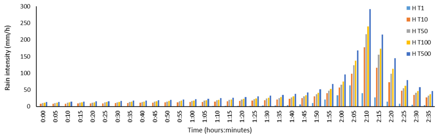
| Historic | 63.6 | 3.05 | 177.2 | 4.06 | 217.2 | 4.40 | 239.6 | 4.54 | 291.7 | 4.85 |
| 2015–2040 | 90.2 | 3.25 | 178.5 | 4.17 | 240.2 | 4.45 | 266.8 | 4.57 | 328.5 | 4.82 |
| 2041–2070 | 93.8 | 3.17 | 185.5 | 4.11 | 249.6 | 4.46 | 277.3 | 4.61 | 341.4 | 4.94 |
| 2071–2100 | 103.1 | 2.92 | 199.6 | 4.12 | 267.1 | 4.52 | 296.2 | 4.68 | 363.6 | 5.03 |
| Adaptation Measure | Model Element Modified | Parameter Modified | Modification Applied |
|---|---|---|---|
| Porous pavements | Subcatchments (land-use type) | Runoff contributing area | 9% reduction in the effective street runoff area |
| Green roofs | Subcatchments (roof surface type) | Initial losses | Increased from 3 mm to 7 mm |
| Manning roughness | Increased from 0.015 to 0.4 | ||
| Bioretention areas | Subcatchments (roof contributing area) | Runoff contributing area | 12% reduction in total roof contributing area |
| Municipality | Av. Correction Coefficient | Municipality | Av. Correction Coefficient | Municipality | Av. Correction Coefficient |
|---|---|---|---|---|---|
| Badalona | 0.58 | El Prat de Ll. | 0.42 | St. Boi de Ll. | 0.55 |
| Badia de V. | 0.46 | Esplugues de Ll. | 0.68 | St. Climent de Ll. | 0.42 |
| Barberà del V. | 0.56 | Gavà | 0.64 | St. Cugat del V. | 0.76 |
| Barcelona | 1.00 | L’Hospitalet de Ll. | 0.44 | St. Feliu de Ll. | 0.61 |
| Begues | 0.58 | La Palma de Cervelló | 0.42 | St. Joan Despí | 0.63 |
| Castellbisbal | 0.50 | Molins de Rei | 0.60 | St. Just Desvern | 0.74 |
| Castelldefels | 0.71 | Montcada i Reixac | 0.55 | St. Vicenç dels Horts | 0.52 |
| Cerdanyola del V. | 0.58 | Montgat | 0.60 | Sta. Coloma de C. | 0.42 |
| Cervelló | 0.51 | Pallejà | 0.53 | Sta. Coloma de G. | 0.52 |
| Corbera de Ll. | 0.50 | Ripollet | 0.54 | Tiana | 0.64 |
| Cornellà de Ll. | 0.57 | Sant Adrià de B. | 0.42 | Torrelles de Ll. | 0.51 |
| El Papiol | 0.43 | St. Andreu de la B. | 0.54 | Viladecans | 0.56 |
| Economic Damage to Properties per Return Period and Projection Periods (Percentage of Change When Comparing SH to MH and MH to AD Scenarios) | |||
|---|---|---|---|
| T1 | |||
| Projection Period | SH Scenario | MH Scenario | AD Scenario |
| Historic | 0.01 M€ | 0.15 M€ (>100%) | 0.13 M€ (−10%) |
| Period 1 (2015–2040) | 4.4 M€ | 4.8 M€ (+9%) | 4.0 M€ (−16%) |
| Period 2 (2041–2070) | 4.8 M€ | 5.2 M€ (+8%) | 4.2 M€ (−20%) |
| Period 3 (2071–2100) | 7.8 M€ | 8.1 M€ (+4%) | 6.6 M€ (−19%) |
| T10 | |||
| Projection Period | SH scenario | MH scenario | AD scenario |
| Historic | 217.4 M€ | 226.4 M€ (+4%) | 185.5 M€ (−18%) |
| Period 1 (2015–2040) | 252.2 M€ | 264 M€ (+5%) | 221.0 M€ (−16%) |
| Period 2 (2041–2070) | 267.8 M€ | 279.6 M€ (+4%) | 239.6 M€ (−14%) |
| Period 3 (2071–2100) | 293.8 M€ | 306.9 M€ (+4%) | 254.1 M€ (−17%) |
| T50 | |||
| Projection Period | SH scenario | MH scenario | AD scenario |
| Historic | 493 M€ | 516.9 M€ (+5%) | 438.4 M€ (−15%) |
| Period 1 (2015–2040) | 551.3 M€ | 579.8 M€ (+5%) | 514.4 M€ (−11%) |
| Period 2 (2041–2070) | 565.4 M€ | 603.3 M€ (+7%) | 529.6 M€ (−12%) |
| Period 3 (2071–2100) | 648.7 M€ | 683.4 M€ (+5%) | 606.7 M€ (−11%) |
| T100 | |||
| Projection Period | SH scenario | MH scenario | AD scenario |
| Historic | 685.1 M€ | 717.1 M€ (+5%) | 653.5 M€ (−9%) |
| Period 1 (2015–2040) | 750.3 M€ | 785.8 M€ (+5%) | 703.9 M€ (−10%) |
| Period 2 (2041–2070) | 767 M€ | 809.5 M€ (+6%) | 716.8 M€ (−11%) |
| Period 3 (2071–2100) | 876.5 M€ | 919.8 M€ (+5%) | 821.7 M€ (−11%) |
| T500 | |||
| Projection Period | SH scenario | MH scenario | AD scenario |
| Historic | 1244.2 M€ | 1290.5 M€ (+4%) | 1155.8 M€ (−10%) |
| Period 1 (2015–2040) | 1319.7 M€ | 1371.5 M€ (+15%) | 1245.9 M€ (−9%) |
| Period 2 (2041–2070) | 1344.9 M€ | 1412.9 M€ (+5%) | 1271.3 M€ (−10%) |
| Period 3 (2071–2100) | 1451.3 M€ | 1538.8 M€ (+6%) | 1428.7 M€ (−7%) |
| Projection Period | EAD SH Scenario | EAD MH Scenario | EAD AD Scenario |
|---|---|---|---|
| Historic | 139.8 M€ | 145.9 M€ | 121.2 M€ |
| Period 1 (2015–2040) | 162.3 M€ | 170.2 M€ | 144.6 M€ |
| Period 2 (2041–2070) | 171.1 M€ | 179.4 M€ | 154.7 M€ |
| Period 3 (2071–2100) | 190.3 M€ | 199.2 M€ | 167.9 M€ |
| High-Risk Area for Pedestrians (ha) per Return Period and Projection Periods (Percentage of Change When Comparing SH to MH and MH to AD Scenarios) | |||
|---|---|---|---|
| T1 | |||
| Projection Period | SH Scenario | MH Scenario | AD Scenario |
| Historic | 0.00 | 1.69 (>100%) | 1.68 (−1%) |
| Period 1 (2015–2040) | 19.42 | 22.73 (+17%) | 18.76 (−17%) |
| Period 2 (2041–2070) | 20.94 | 23.99 (+15%) | 20.22 (−16%) |
| Period 3 (2071–2100) | 31.54 | 34.2 (+8%) | 27.86 (−19%) |
| T10 | |||
| Projection Period | SH scenario | MH scenario | AD scenario |
| Historic | 494.14 | 513.02 (+4%) | 449.67 (−12%) |
| Period 1 (2015–2040) | 554.06 | 579.34 (+5%) | 516.88 (−11%) |
| Period 2 (2041–2070) | 577.69 | 601.15 (+4%) | 543.37 (−10%) |
| Period 3 (2071–2100) | 620.75 | 647.06 (+4%) | 575.15 (−11%) |
| T50 | |||
| Projection Period | SH scenario | MH scenario | AD scenario |
| Historic | 918.68 | 952.08 (+4%) | 858.99 (−10%) |
| Period 1 (2015–2040) | 987.67 | 1042.69 (+6%) | 958.47 (−8%) |
| Period 2 (2041–2070) | 1007.35 | 1085.16 (+8%) | 978.5 (−10%) |
| Period 3 (2071–2100) | 1121.02 | 1185.93 (+6%) | 1083.58 (−9%) |
| T100 | |||
| Projection Period | SH scenario | MH scenario | AD scenario |
| Historic | 1174.76 | 1208.21 (+3%) | 1125.2 (−7%) |
| Period 1 (2015–2040) | 1245.11 | 1299.32 (+4%) | 1198.65 (−8%) |
| Period 2 (2041–2070) | 1270.60 | 1333.94 (+5%) | 1214.66 (−9%) |
| Period 3 (2071–2100) | 1400.63 | 1463.34 (+4%) | 1347.11 (−8%) |
| T500 | |||
| Projection Period | SH scenario | MH scenario | AD scenario |
| Historic | 1818.69 | 1798.78 (0%) | 1686.98 (−6%) |
| Period 1 (2015–2040) | 1856.01 | 1916.64 (+3%) | 1782.63 (−7%) |
| Period 2 (2041–2070) | 1879.70 | 1955.57 (+4%) | 1809.08 (−7%) |
| Period 3 (2071–2100) | 1972.91 | 1956.82 (0%) | 1956.74 (0%) |
| High-Risk Roads for Vehicles (km) per Return Period and Projection Periods (Percentage of Change When Comparing SH to MH and MH to AD Scenarios) | |||
|---|---|---|---|
| T1 | |||
| Projection Period | SH Scenario | MH Scenario | AD Scenario |
| Historic | 0.09 | 0.08 (0%) | 0.08 (0%) |
| 2015–2040 | 3.64 | 3.84 (+5%) | 3.37 (−12%) |
| 2041–2070 | 3.66 | 3.91 (+7%) | 3.65 (−7%) |
| 2071–2100 | 5.01 | 4.95 (0%) | 4.48 (−9%) |
| T10 | |||
| Projection Period | SH scenario | MH scenario | AD scenario |
| Historic | 59.11 | 59.05 (0%) | 53.73 (−9%) |
| Period 1 (2015–2040) | 65.32 | 66.7 (+2%) | 60.97 (−9%) |
| Period 2 (2041–2070) | 69.37 | 70.42 (+2%) | 64.71 (−8%) |
| Period 3 (2071–2100) | 74.37 | 75.79 (+2%) | 68.81 (−9%) |
| T50 | |||
| Projection Period | SH scenario | MH scenario | AD scenario |
| Historic | 120.54 | 124.28 (+3%) | 109.23 (−12%) |
| Period 1 (2015–2040) | 132.45 | 137.41 (+4%) | 123.07 (−10%) |
| Period 2 (2041–2070) | 135.54 | 142.53 (+5%) | 127.73 (−10%) |
| Period 3 (2071–2100) | 151.54 | 159 (+5%) | 145.83 (−8%) |
| T100 | |||
| Projection Period | SH scenario | MH scenario | AD scenario |
| Historic | 160.17 | 163.88 (+2%) | 153.76 (−6%) |
| Period 1 (2015–2040) | 172.55 | 177.45 (+3%) | 165.58 (−7%) |
| Period 2 (2041–2070) | 175.47 | 183.57 (+5%) | 168.13 (−8%) |
| Period 3 (2071–2100) | 198.88 | 207.18 (+4%) | 187.27 (−10%) |
| T500 | |||
| Projection Period | SH scenario | MH scenario | AD scenario |
| Historic | 271.26 | 274.77 (+1%) | 252.23 (−8%) |
| Period 1 (2015–2040) | 282.11 | 294.77 (+4%) | 268.84 (−9%) |
| Period 2 (2041–2070) | 287.24 | 301.79 (+5%) | 274.4 (−9%) |
| Period 3 (2071–2100) | 306.55 | 308.3 (+1%) | 304.36 (−1%) |
Disclaimer/Publisher’s Note: The statements, opinions and data contained in all publications are solely those of the individual author(s) and contributor(s) and not of MDPI and/or the editor(s). MDPI and/or the editor(s) disclaim responsibility for any injury to people or property resulting from any ideas, methods, instructions or products referred to in the content. |
© 2026 by the authors. Licensee MDPI, Basel, Switzerland. This article is an open access article distributed under the terms and conditions of the Creative Commons Attribution (CC BY) license.
Share and Cite
de la Cruz-Coronas, À.; Russo, B.; Pacho-Gómez, S.; Yubero-Peña, D. Socio-Economic Impacts of Pluvial Floods in the Metropolitan Area of Barcelona in a Climate Change Context. Sustainability 2026, 18, 4530. https://doi.org/10.3390/su18094530
de la Cruz-Coronas À, Russo B, Pacho-Gómez S, Yubero-Peña D. Socio-Economic Impacts of Pluvial Floods in the Metropolitan Area of Barcelona in a Climate Change Context. Sustainability. 2026; 18(9):4530. https://doi.org/10.3390/su18094530
Chicago/Turabian Stylede la Cruz-Coronas, Àlex, Beniamino Russo, Sofia Pacho-Gómez, and Daniel Yubero-Peña. 2026. "Socio-Economic Impacts of Pluvial Floods in the Metropolitan Area of Barcelona in a Climate Change Context" Sustainability 18, no. 9: 4530. https://doi.org/10.3390/su18094530
APA Stylede la Cruz-Coronas, À., Russo, B., Pacho-Gómez, S., & Yubero-Peña, D. (2026). Socio-Economic Impacts of Pluvial Floods in the Metropolitan Area of Barcelona in a Climate Change Context. Sustainability, 18(9), 4530. https://doi.org/10.3390/su18094530