1. Introduction
1.1. Purpose of Study
In the architectural design process, site context extends beyond mere physical boundaries and functions as a fundamental constraint that defines the form and placement of a building, serving as the primary point of departure for design. A building is not an autonomous object detached from its territory; rather, it is an urban artifact organically intertwined with the historical specificity and unique identity of a place, thereby maintaining an intimate relationship with the site [
1]. From this perspective, the building footprint represents the boundary where the city’s vacant external space (void) meets the physical mass (solid). Consequently, the city’s physical order, such as the surrounding street network and parcel configuration, becomes manifest in the concrete form of the building.
The building footprint should not be perceived merely as a byproduct of internal spatial organization or programmatic requirements; rather, it functions as an urban poché that actively shapes and defines the character of the surrounding external space [
2]. When the geometric alignments of adjacent streets and neighboring buildings intersect within the site boundary to establish an underlying order—specifically, a logic of “collision”—the building attains morphological validity in harmony with its urban environment [
3]. In this sense, the generation of a footprint is not a formal exercise driven by subjective preference; instead, it must be understood as a logical process of interpreting complex contextual information and deriving an optimized form that responds to site constraints.
Such context-aware design can be understood as an important approach to promoting urban sustainability, extending beyond mere aesthetic harmony [
4,
5,
6]. “Lost space,” which occurs when a building exists as an isolated object detached from its surroundings, is widely recognized as a contributing factor to fragmentation in the physical and social continuity of the city [
7]. This condition may hinder efficient land use and degrade the quality of the pedestrian environment, ultimately increasing urban resource consumption and challenging long-term sustainability [
8]. Therefore, building footprints generated through site context analysis can help reduce underutilized spaces and support the formation of a more compact, pedestrian-oriented urban fabric. While geometric alignment alone does not guarantee improved urban performance, it may provide a morphological baseline upon which environmentally and socially sustainable urban planning can be further developed.
Despite these design and urban imperatives, generative AI-based design processes, which have recently been actively explored in architectural design, are still often conducted in a fragmented manner, with limited incorporation of site context [
9]. Even existing footprint generation models that directly address site conditions tend to reflect basic physical boundaries, thereby presenting an opportunity for further exploration in producing forms that establish meaningful relationships with the essential urban fabric required for practical architectural design [
10,
11,
12]. In this context, integrating site conditions in early-stage design is not only a matter of formal coherence but also relates to broader considerations of urban sustainability, as spatial configuration directly influences land-use efficiency, environmental performance, and the organization of built and open spaces [
13,
14].
Accordingly, this study proposes a generative AI framework for building footprint generation that incorporates complex site contextual information. Leveraging its strong capability for contextual generation, a Latent Diffusion Model (LDM) with a conditional inpainting mechanism is employed to integrate structured spatial constraints—including sidewalks, roadways, adjacent buildings, and site boundaries—as multi-channel contextual inputs. To examine the extent to which multi-channel spatial control enhances the morphological convergence of the generative model’s outputs, information entropy is employed as an evaluation metric. Through this approach, the study seeks to provide empirical support for the feasibility of deriving initial design proposals that reflect site context, while establishing a foundational generative methodology for future research in related fields.
1.2. Research Methods and Procedures
The following outlines the key steps employed in this study to generate architectural footprints that reflect site context.
Review of related studies and theoretical background: Existing deep learning-based studies addressing architectural footprint generation were examined, and the analogies between information processing in architectural design and the technical mechanisms of the Latent Diffusion Model (LDM) were explored.
Implementation of the context-conditioned generative architecture: The perceptual compression process via a Variational Autoencoder (VAE) and the denoising process utilizing U-Net skip connections were implemented. In particular, the integration mechanism for latent inpainting and spatial control conditions, which forms the core operational framework of this study, was presented.
Construction of a multi-channel dataset and model training: To enable the model to learn the geometric context of urban fabrics, a four-channel dataset—representing sidewalks, roadways, adjacent buildings, and site boundaries—was constructed based on expert-designed cases. The model was then fine-tuned on Stable Diffusion v1.5 using a null-embedding technique and Classifier-Free Guidance (CFG).
Quantitative and qualitative validation: An ablation study was conducted to compare generative performance with and without site context information. Information entropy served as the primary evaluation metric to quantitatively assess the model’s capacity to control uncertainty, while the architectural validity of the generated footprints was evaluated qualitatively through case-based analysis.
Conclusions: The principal findings of the study were summarized, and future research directions were proposed, including approaches to address the study’s limitations and potential extensions toward an integrated architectural design process.
2. Literature Review
Research on architectural design automation and footprint generation has evolved from geometry-based rule systems to optimization-driven search methods and, more recently, to deep learning approaches. Early systems relied on explicitly encoded geometric rules to control spatial configurations, whereas optimization-driven methods focused on performance-based search strategies. More recently, deep learning approaches have enabled models to extract implicit design patterns directly from data.
2.1. Geometry-Based Rule Approaches
Early attempts at architectural form generation were predominantly grounded in shape grammar, which derives forms through designer-defined rule systems. Formalized by Stiny and Gips (1971) [
15], shape grammar established a foundational logic for design generation by recursively applying transformation rules to an initial shape. Müller et al. (2006) [
16] subsequently extended this framework to the urban scale, introducing a computer-generated architectural shape grammar that enables the procedural generation of buildings and urban fabrics.
However, such rule-based approaches exhibit inherent limitations. They require experts to explicitly encode complex domain knowledge, which poses significant challenges in terms of scalability and adaptability. Moreover, they struggle to accommodate unforeseen site contexts or irregular geometric conditions that are not predefined within the rule set. In other words, while rule-based systems maintain formal rigor, they remain constrained in their capacity to absorb the irregular and heterogeneous conditions of urban environments [
17,
18,
19].
2.2. Optimization Approaches
To overcome the rigidity of rule-based models and achieve quantifiable performance objectives, optimization techniques such as Genetic Algorithms (GA) were introduced. Park (2005) [
20] utilized a parametric design process to generate high-rise building forms that satisfy structural and functional requirements. Caldas (2005) [
21] employed a Pareto-based genetic algorithm to propose a methodology for generating three-dimensional architectural forms optimized for daylighting and thermal performance. More recently, Wang et al. (2024) [
22] introduced “EvoMass,” a framework for exploring and optimizing diverse building massing typologies during the early design phase. While optimization-based approaches effectively satisfy quantifiable metrics such as floor area ratio or energy efficiency, they exhibit limitations in incorporating non-quantifiable contextual information, including visual order and geometric patterns of the urban fabric. Furthermore, because optimization processes must be re-executed whenever design objectives change, such methods remain limited in their applicability as generative models capable of responding instantaneously to diverse site conditions [
11,
23].
2.3. Deep Learning Approaches
Recently, deep learning models capable of learning latent features from large-scale design datasets have emerged as a promising alternative. Generative models such as GANs (Generative Adversarial Networks) and VAEs (Variational Autoencoders) have been actively adopted in architectural design research, with diffusion models gaining increasing attention [
24]. In particular, recent diffusion models, including Latent Diffusion Models (LDMs), have been applied across various architectural domains, ranging from 3D massing and urban block generation [
25,
26] to multi-conditional floor plan generation [
27,
28]. While these studies primarily focus on the formal exploration of individual buildings, interior layouts, or 3D visual representations—often guided by text prompts—the application of diffusion models to 2D building footprint generation, specifically conditioned on complex urban fabrics such as surrounding street networks and adjacent buildings, remains relatively limited. Consequently, existing studies on deep learning-based footprint generation that consider site conditions have predominantly relied on earlier generations of models (e.g., GANs, VAEs), which may limit their ability to actively respond to complex urban constraints. Existing deep learning-based footprint generation studies can be categorized into coordinate regression approaches and image generation approaches.
Rhee et al. (2020) [
11] proposed a method that modifies a VGG (Visual Geometry Group) network to directly predict the vertex coordinates of a quadrilateral footprint from site images. While this approach deliberately approximates results as quadrilateral vector data to ensure computational efficiency and seamless integration with downstream design workflows, it leaves room for further adaptation to represent polygons or irregular footprints that respond to intricate urban fabrics.
A representative image-generation study by Chaillou (2020) [
10] introduced ArchiGAN, a Pix2Pix-based GAN model that employs a “Generation Stack” framework to sequentially generate footprints, floor programs, and furniture layouts from parcel images. Although this method demonstrated flexibility in generating forms under irregular site conditions through pixel-level learning, it relied solely on parcel shape as input and did not sufficiently incorporate contextual information such as surrounding street networks or adjacent buildings. Additionally, due to inherent characteristics of GANs, which may struggle to fully capture the variability of data distributions, the exploration of diverse design alternatives under complex site conditions remained constrained [
29].
Zhuang et al. (2023) [
30] generated three-dimensional architectural volumes using 3D voxels and Signed Distance Functions (SDFs). However, this approach primarily focused on the formal generation of isolated objects rather than explicitly addressing contextual interactions with surrounding environments. More recently, Wu et al. (2025) [
12] proposed “DeepCanvas,” a vision-based deep reinforcement learning framework in which an agent sequentially places geometric elements to learn context-aware policies. However, because this method relies on sequential decision-making processes, it emphasizes stepwise generation rather than the simultaneous integration of global image context.
Unlike previous studies, the Latent Diffusion Model (LDM) adopted in this study preserves contextual information and, through conditional inpainting, is capable of generating forms that reflect physical site constraints, such as roads and adjacent buildings. Leveraging these characteristics, this study generates footprints that reflect multi-channel site information and quantitatively verifies, through information entropy, how contextual inputs regulate uncertainty in generative outcomes.
3. Theoretical Background
This chapter examines the principles and structure of the LDM as the technical foundation for architectural footprint generation. It first explores the conceptual similarities between the information-processing workflow of early-stage architectural design and the generative mechanisms of diffusion models. On this basis, it provides a detailed account of the technical system through which data compression, form generation, and context-responsive conditional inpainting are implemented.
3.1. Conceptual Analogies Between Diffusion Models and Architectural Design
In the early stages of architectural design, complex external constraints derived from site context are interpreted and translated into a fundamental geometric order, which is subsequently developed into a concrete physical form [
31]. The process by which a designer analyzes site information in the initial phase and progressively constructs a more concrete form from abstract ideas constitutes a generative transformation achieved through analysis and synthesis [
32]. This process is conceptually analogous to the generative mechanisms of diffusion models, which derive meaningful structures from random noise. In addition, the extended information-processing flow—from condition to abstraction to concretization—also aligns with the architecture of the Variational Autoencoder (VAE), through which data are compressed and reconstructed. The Latent Diffusion Model (LDM) employed in this study is grounded in this structural framework and separates the training process into two stages: perceptual compression and semantic learning [
33].
The LDM first employs a VAE to compress (encode) complex image data into a latent space that captures its essential features. It then utilizes a U-Net to generate latent vectors within this space that conform to the site context, which are subsequently reconstructed (decoded) into corresponding spatial forms. This stepwise configuration exhibits structural similarity to the architectural design process, in which a designer identifies the essence of a site (compression), explores alternatives within it (generation), and ultimately produces a concrete drawing (reconstruction).
3.2. VAE: Perceptual Compression and Latent Representation
The Variational Autoencoder (VAE), the first component of the Latent Diffusion Model (LDM), transforms high-dimensional image data into a lower-dimensional latent space that is computationally more efficient to process [
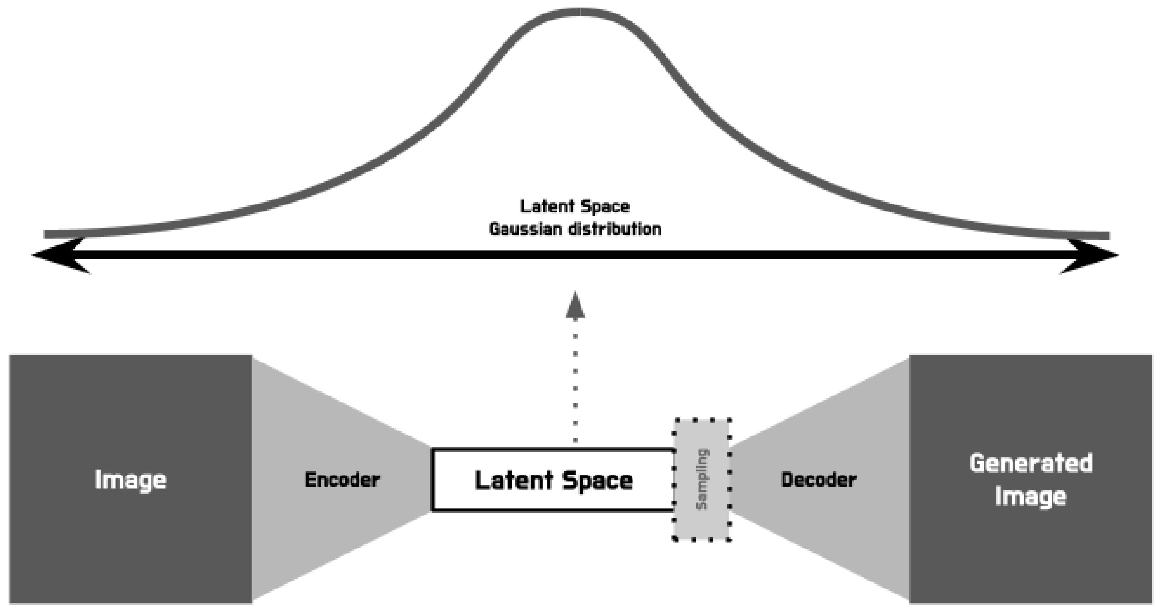
33]. As illustrated in
Figure 1, a VAE generally consists of a symmetric architecture with an encoder and a decoder. The encoder removes redundant information from the high-resolution input image and extracts only its essential features, encoding them into a latent variable
. This latent variable is represented not as a deterministic value but as a probability distribution, enabling the model to learn the statistical characteristics of the data. The decoder then reads the information encoded in the latent space and reconstructs an output that closely resembles the original image [
34,
35].
The core mechanism here is perceptual compression. Rather than preserving fine-grained, pixel-level color values, perceptual compression refers to a technique that compresses data while retaining geometric semantics salient to human perception, such as building outlines or the linear geometry of roads. Within an LDM, the VAE substantially reduces the dimensionality of the data while preserving only such semantic information. As a result, the latent space formed by the VAE attains high information density, in which essential architectural order is retained.
The latent inpainting technique adopted in this study is also executed within this compressed latent space. The VAE encoder projects not only the target footprint to be generated but also multi-channel site context data—including surrounding roads and buildings—into the same latent space. By conducting the diffusion process exclusively within this compact and refined latent domain, the LDM significantly reduces the computational cost associated with pixel-space operations and enables the model to focus on essential correlations between site context and form. Once the generative process is complete, the VAE decoder reconstructs the results from the latent space into footprint images, thereby producing the final architectural forms.
3.3. U-Net: Semantic Learning and Conditional Generation
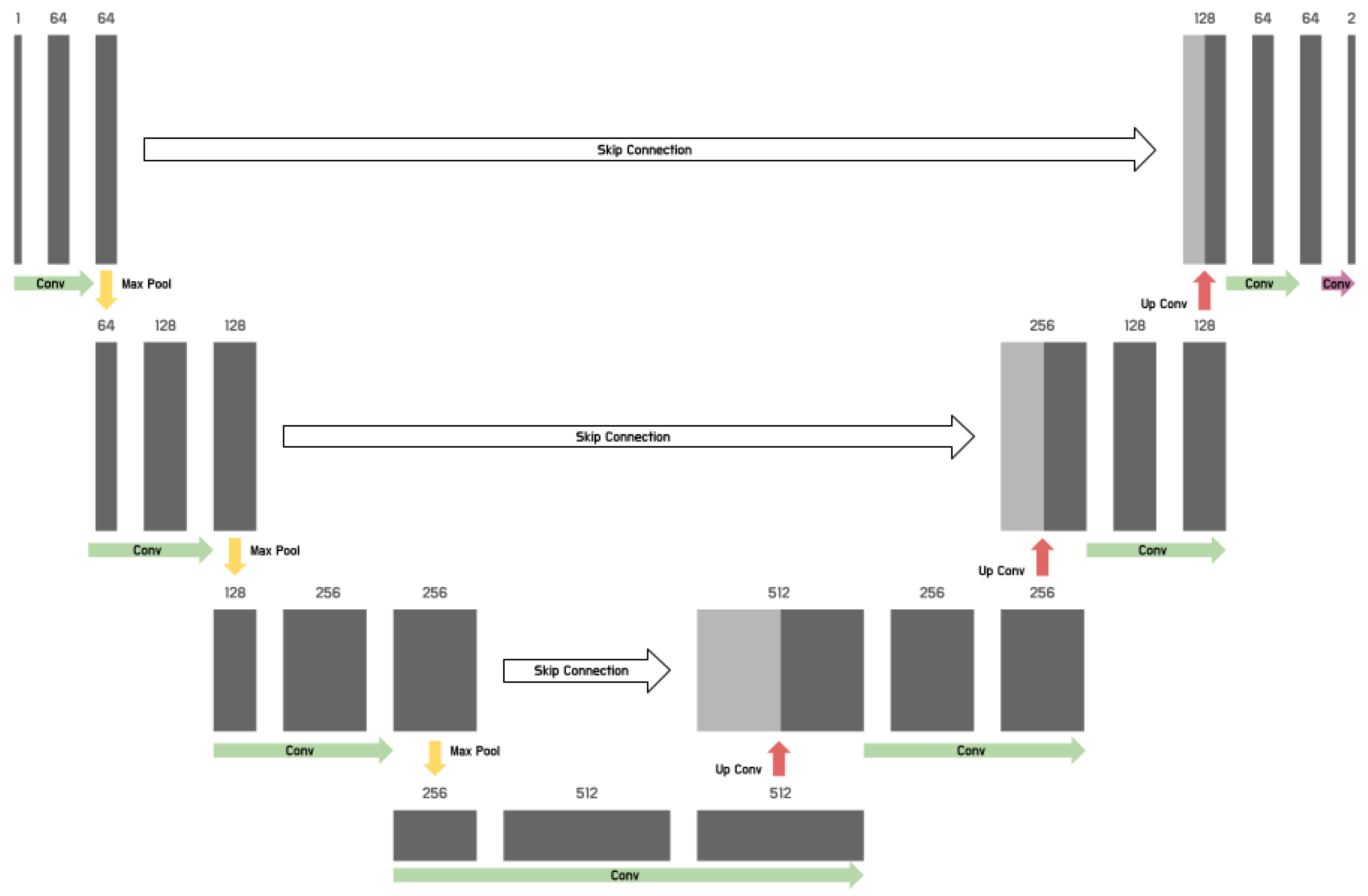
The U-Net, the second component of the LDM, is a symmetric encoder–decoder architecture originally developed for image segmentation. As illustrated in
Figure 2, it features skip connections that transfer high-level features from the encoder directly to the decoder at corresponding resolutions [
36].
While the VAE compresses fine-grained image details into a low-dimensional latent representation, the U-Net operates within this compressed latent space to learn global structures and contextual relationships by predicting and removing noise. One of the primary reasons the U-Net can be effectively employed for generative tasks in diffusion models, rather than for its original segmentation purpose, is that its skip connections preserve the spatial resolution of latent representations, enabling the simultaneous reconstruction of global structures and local details. Based on these characteristics, the U-Net performs the reverse diffusion process, progressively reconstructing meaningful data structures from complex noise distributions in the latent space.
In the Latent Diffusion Model (LDM) framework, the U-Net receives three types of input: (1) the noisy latent variable
zt at the current timestep; (2) the timestep
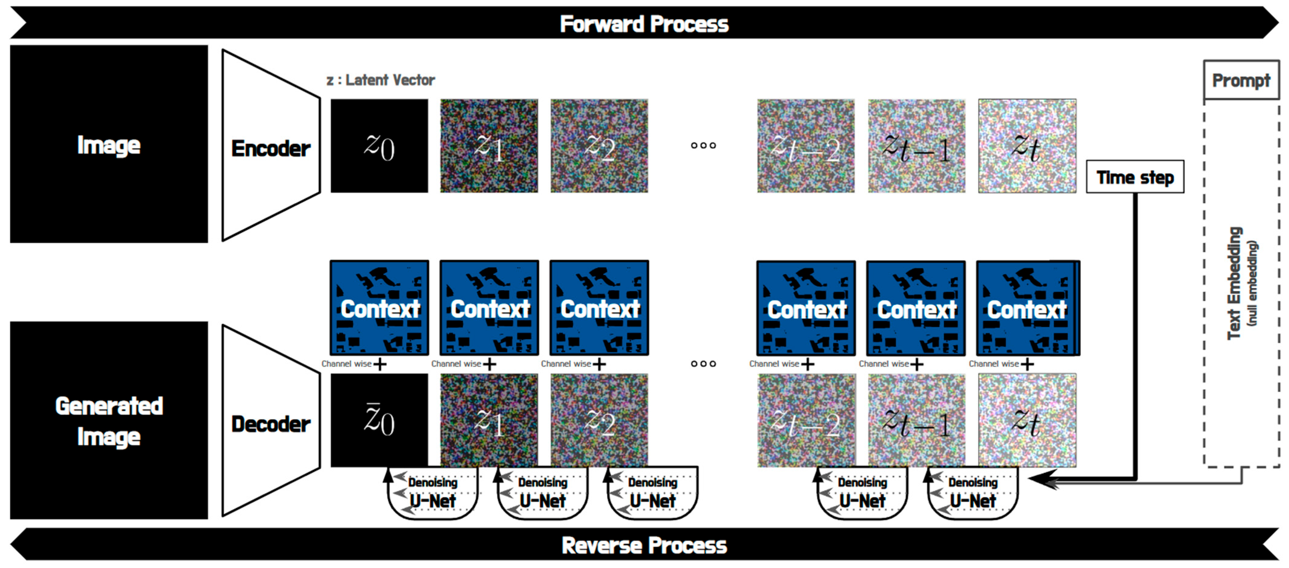
, which controls the denoising stage; and (3) the external conditioning information C, which guides the direction of generation. As shown in
Figure 3, the model incorporates conditioning information through a cross-attention mechanism positioned between the encoder and decoder. By integrating this conditional information into the noise prediction process, the U-Net progressively estimates and removes noise at each step, aligning the generated output with the given conditions.
To precisely reflect site context, this study extends the input channels of the U-Net and applies a conditional concatenation mechanism. At the input stage of the inpainting U-Net, the current noisy latent variable
zt is concatenated along the channel dimension with the contextual latent representation encoded by the VAE and the mask variable defining the target generation region. Through this concatenation, the model conditions footprint generation not only on the probabilistic latent distribution but also on the physical locations and geometric attributes encoded in the contextual latent representations, which function as conditioning constraints. The extended input tensor
processed by the U-Net is defined as follows [
33]:
: the extended input tensor to the inpainting U-Net.
: the noisy latent variable at time step t.
: the original site context encoded by the VAE encoder.
: the original site context image.
: the binary mask defining the generation region within the site boundary.
: the neutral padding value, e.g., 0.5, applied to the generation region.
: the element-wise product preserving the contextual region.
: the down-sampled binary mask matching the resolution of the latent space.
Furthermore, unlike conventional LDMs that primarily utilize text prompts as conditional inputs, this study adopts a null-embedding approach in which all text embeddings are fixed to zero. This method eliminates subjectivity and ambiguity inherent in linguistic descriptions and ensures that the model conditions generation solely on the geometric order of the surrounding environment, which is concatenated along the channel axis to serve as its generative constraint. As a result, the U-Net integrates its internally refined reconstruction architecture with externally provided multi-channel contextual conditions, enabling it to derive appropriate footprint patterns that geometrically respond to site context within the latent space.
4. Research Methodology
4.1. Dataset Construction
4.1.1. Data Preparation
To learn the correlation between the geometric constraints of a site and architectural form, this study selected systematically planned new-town districts and prominent landmark projects that clearly reflect modern urban design principles as training data. While the irregular and organic fabrics of Korean old urban areas hold distinct historical and morphological value, their direct inclusion in the initial training process presents challenges due to differences in geometric structure and planning logic. Therefore, this study utilized new towns—where the geometric order of contemporary urban planning (e.g., grid-based street networks and standardized parcels) is clearly evident—as the primary dataset. Furthermore, to ensure the quality and architectural validity of the training data, the “expert-designed cases” were selected to include relatively recent buildings that satisfy modern regulatory constraints (e.g., building coverage ratio and floor area ratio) and demonstrate a clear alignment with surrounding street axes through context-responsive architectural design. By securing sites in which geometric context is clearly articulated, the dataset enables the model to autonomously learn design logic that responds to street axes and surrounding building arrangements, rather than producing arbitrary formal compositions [
2].
For data acquisition, digital topographic maps (SHP files) provided by the National Geographic Information Institute, South Korea, were utilized [
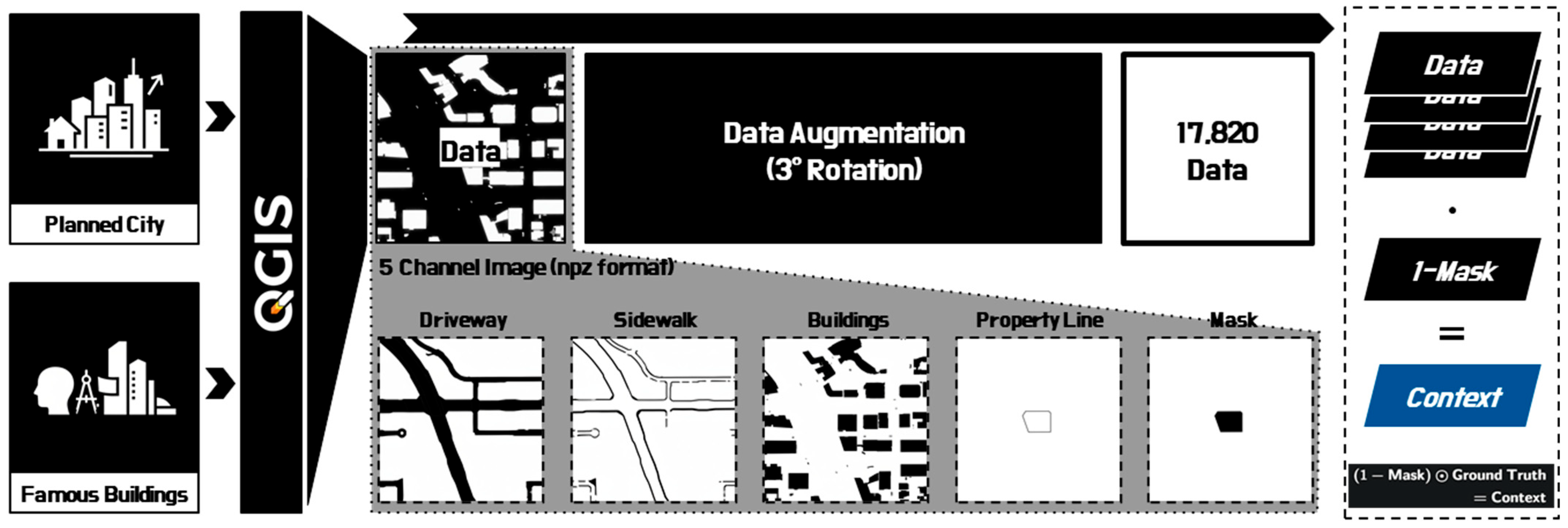
37]. The study dataset comprised 144 zones. These included major metropolitan new towns in South Korea—Bundang, Pangyo, and Magok—characterized by grid-based street systems and standardized parcel subdivisions that facilitate clear interpretation of urban context, as well as areas surrounding landmark architectural projects in Korea and abroad. Subsequently, the required information was separated into individual layers using QGIS (version 3.38.2) [
38]. The extracted data were stored, as shown in
Figure 4, as four contextual layers—sidewalks, roadways, adjacent buildings, and site boundaries—along with an additional mask image in which the interior of the site boundary was filled to enable the application of the inpainting mechanism.
4.1.2. Data Preprocessing and Augmentation
The collected 144 original zone datasets were shuffled and split into training, validation, and test sets at a ratio of 8:1:1, resulting in 115, 14, and 15 zones, respectively. To overcome the limitations arising from the relatively small dataset size and to enhance the stability of model training, data augmentation was performed. For the training and validation sets, the original images were rotated clockwise in 3-degree increments, generating 119 additional samples per zone. Unlike natural or street-view images, which possess a fixed vertical orientation due to gravity, top-down urban maps are primarily characterized by the relative geometric relationships between parcels, roads, and surrounding buildings rather than absolute cardinal directions. In CNN-based models, which inherently lack rotation invariance, rotational augmentation of such spatial data can introduce diverse angular variations of street intersections and adjacent building configurations, rather than simply duplicating the original data. Geometric transformations such as rotation can serve as an effective means to mitigate positional and directional biases in training data, provided that the essential spatial structure is preserved [
39]. Since the relative spatial logic in top-down maps remains consistent across rotations, this 360-degree augmentation helps reduce overfitting to specific absolute orientations and supports the learning of generalized geometric relationships under varying contextual conditions. As a result, 13,800 images were used for training and 1680 images were used for validation. For testing, the 15 original zones were used without data augmentation.
The preprocessed dataset was refined through the following steps to meet the model’s input requirements:
The stored PNG images were converted into single-channel data composed of binary values (0 and 1).
The five separated images (sidewalks, roadways, adjacent buildings, site boundaries, and masks) were combined into a five-channel tensor to form a unified dataset.
To optimize storage efficiency for large-scale dataset processing, the final outputs were saved as compressed NumPy files (.npz).
4.2. Model Architecture
This study employs a fine-tuned latent diffusion model based on the pre-trained Stable Diffusion v1.5 [
33] to incorporate site context information as a control condition. The model architecture consists of a VAE that compresses high-resolution images into a latent space and reconstructs them, and a U-Net that generates forms aligned with the context within this compressed latent space.
4.2.1. Context Encoding and Neutral Padding
The constructed five-channel tensor was resized to a spatial resolution of 512 × 512 pixels to match the input specifications required for model training. In the inpainting learning process, the data were separated and processed as a context image and a ground truth image in order to clearly distinguish between the conditional input and the reconstruction target. The detailed procedure is described as follows.
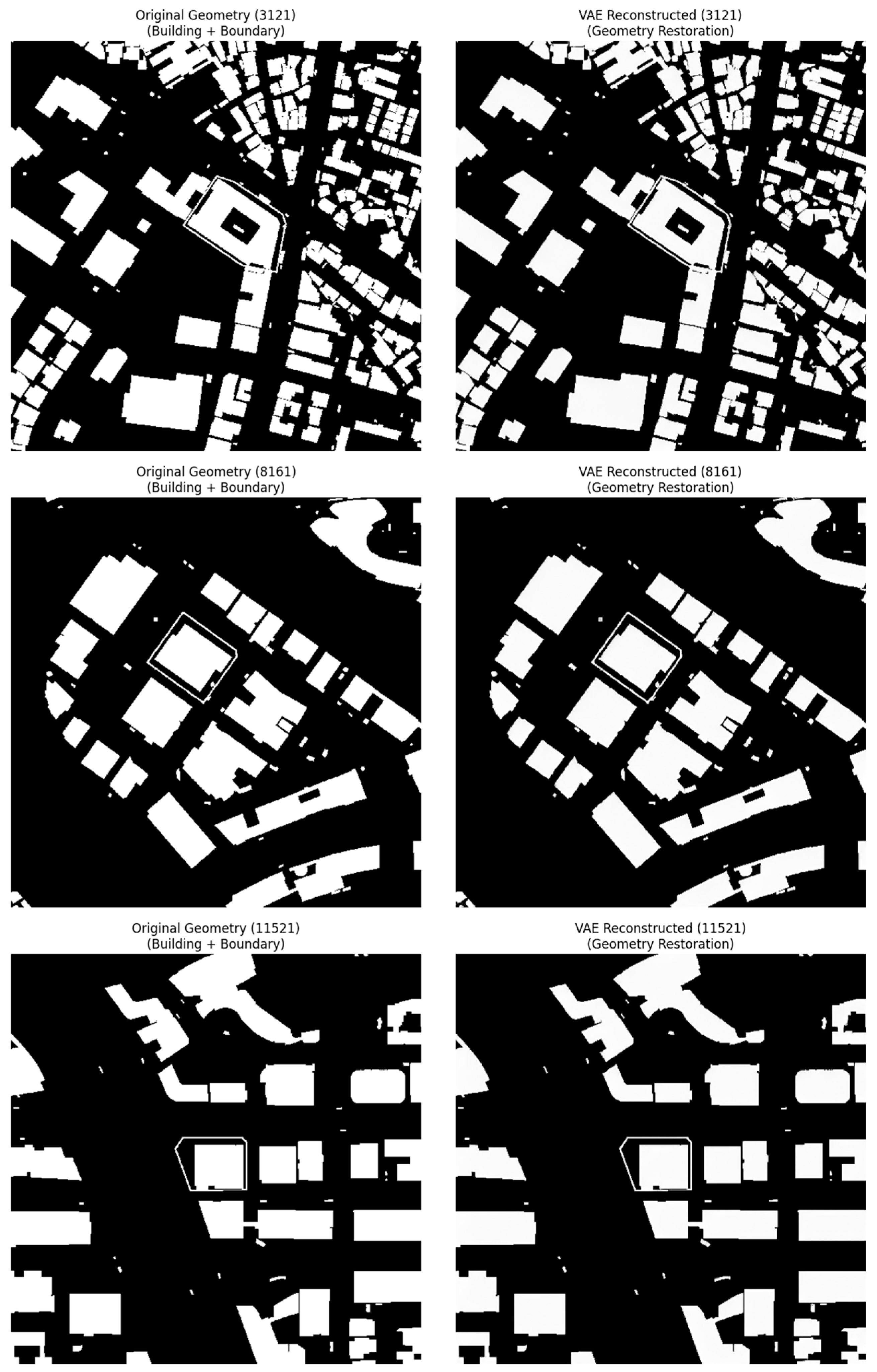
First, to accommodate the VAE’s 3-channel input constraint, the site boundary and adjacent building layers within the context data were merged into a single representation and converted into a 3-channel RGB format. This approach is based on the assumption that the VAE has a strong capability to preserve geometric essence during compression and reconstruction. As illustrated in
Figure 5, the geometric characteristics of the site boundaries and adjacent buildings appear to be preserved after being merged into the 3-channel RGB format for VAE processing, without spatial confusion or information loss. This can be attributed to the distinct geometric and topological characteristics of the two layers, where site boundaries form thin, hollow linear loops and adjacent buildings consist of filled polygonal regions, thereby allowing the model to differentiate them at the pixel level. Therefore, even if information overlap occurs due to channel merging, the morphological characteristics are expected to be adequately preserved within the latent space.
Subsequently, a mask was applied to the original image to establish the inpainting guideline. During this step, a neutral padding technique was employed, in which a constant value of 0.5 was added to the pixels within the site boundary (the generation region), rendering them gray. Rather than completely removing the generation region, this approach fills it with a neutral value, thereby preventing the model from being biased toward any specific color or residual information during the encoding process. As a result, the model is encouraged to focus solely on the surrounding contextual information when performing the denoising step of the diffusion process.
4.2.2. U-Net Expansion for Latent Context Integration
While leveraging the pre-trained weights of Stable Diffusion v1.5, this study fine-tuned a partially expanded U-Net architecture to directly incorporate site context information within the latent space. Initially, the pre-trained VAE was maintained in a frozen state, serving to compress high-dimensional images into latent representations of size 64 × 64 × 4.
For the U-Net, where the actual learning occurs, the original four-channel input layer was expanded to eight channels. The noisy latent variable to be denoised (4 channels) and the contextual latent projected through the VAE (4 channels) were concatenated along the channel dimension and injected simultaneously into the network. Through this structural modification, the model generates footprints by directly referencing the physical spatial information of the site context as a primary guideline at each denoising step.
4.2.3. Contextual Control and Morphological Diversity
To ensure diversity in architectural form generation under identical site conditions and to flexibly regulate the strength of contextual control, Classifier-Free Guidance (CFG) and spatial condition dropout were introduced [
40]. To implement the CFG mechanism, the previously described null-embedding method was applied in place of a text prompt. This approach eliminates the potential subjectivity introduced by linguistic descriptions and directs the model to focus exclusively on geometric information, thereby encouraging architectural forms to emerge from the physical order of the site.
In addition, a dropout rate of 10% was applied during the training process to intentionally omit the site context latent variables. This procedure prevents the model from merely replicating the provided boundary information and enables it to jointly learn the general distribution of architectural forms in the absence of site constraints, thereby establishing a foundation for morphological diversity. This dropout rate was motivated by the foundational CFG study by Ho and Salimans (2022) [
40], which empirically demonstrated that an unconditional training probability of 10% to 20% provides a favorable balance in sample quality. In the final inference stage, the guidance scale (
) was adjusted to optimize the balance between conformity to the site context and formal variation. The weighted prediction [
40] is defined as follows:
: the final noise prediction with guidance.
: the noise prediction without conditioning.
: the conditional noise prediction given the site context.
: the guidance scale controlling the strength of site context conditioning.
Regarding the guidance scale (), a preliminary sensitivity analysis was conducted within the range of 1.0 to 2.0. The results showed that values exceeding 1.5 were found to cause geometric distortion, where the generated footprints overly adhered to the site boundaries, resulting in geometrically implausible or impractical architectural forms. Conversely, values near 1.0 resulted in a lack of spatial alignment with the surrounding context. Based on these observations, was adopted as it provides a balance between geometric plausibility and architectural morphological diversity.
4.3. Experimental Evaluation
4.3.1. Ablation Study
To empirically evaluate the effectiveness of the four-channel contextual information, an ablation study [
41] was conducted by configuring two experimental models with different levels of contextual input and performing a comparative analysis. The training and generation settings of the proposed model and the comparison model are as follows:
Model A (Proposed Model): Incorporates four-channel contextual information, including sidewalks, roadways, adjacent buildings, and site boundaries.
Model B (Comparison Model): Incorporates only a single channel corresponding to site boundaries.
Both models were trained using the same dataset and hyperparameters. The only difference lies in the composition of the conditional latent variables () provided to the U-Net. This difference in contextual composition enables a comparative evaluation of how effectively stochastic variation is regulated during footprint generation while simultaneously providing contextual grounding for form derivation.
4.3.2. Pixel-Wise Mean Information Entropy
To support the qualitative analysis and quantitatively verify the impact of the provided information on the generative model’s uncertainty, this study utilized information entropy as an evaluation metric. Entropy serves as a measure of uncertainty in a probability distribution; it yields lower values when generated results are concentrated on specific forms, whereas higher values indicate a broader distribution and increased uncertainty [
42,
43].
To compute this metric, 100 inference runs were conducted under a single site condition, producing 100 grayscale images. For each pixel coordinate, the distribution of intensity values across the generated images was constructed and normalized to form a probability distribution. The entropy at each pixel location
was then computed by applying this distribution to Shannon’s entropy formulation [
43], as follows:
: the information entropy at pixel (y, x).
: the random variable representing the pixel intensity.
: the pixel intensity value (0–255; 8-bit grayscale).
the probability of intensity value b across 100 generations.
Finally, the mean entropy value was computed over the valid generation region, excluding background pixels. This study defines this value as the final uncertainty metric of the model, thereby quantifying the degree of morphological certainty established by the site context.
4.4. Experimental Setup and Training
4.4.1. Computing Environment and Hyperparameter Settings
Model training and inference in this study were conducted using an NVIDIA A100 GPU within the Google Colab Pro+ environment to facilitate high-performance computation. The LDM pipeline was implemented in PyTorch (version 2.8.0+cu126) as the primary deep learning framework, together with the Diffusers library provided by Hugging Face.
The hyperparameters for model training were determined through preliminary experiments. The batch size was set to 16, which was the maximum feasible value under the NVIDIA A100 GPU memory constraints while avoiding out-of-memory errors and maintaining stable training. The learning rate was fixed at 5 × 10⁻⁵, which is commonly used for stable fine-tuning of pre-trained Latent Diffusion Models. The AdamW optimizer was employed for parameter optimization. The maximum number of training epochs was set to 150, and an early stopping criterion was applied to reduce computational cost.
4.4.2. Loss Function and Training Stabilization
The objective of diffusion model training is to reconstruct the original latent representation from a noise-perturbed latent variable. To achieve this, the mean squared error (MSE) between the noise predicted by the model () and the actual injected Gaussian noise (ϵ) was adopted as the loss function.
To improve training efficiency and stability, the following techniques were applied:
Mixed Precision Training: Automatic Mixed Precision (AMP) with FP16 precision was employed to improve computational speed and reduce memory consumption.
Gradient Clipping: To prevent gradient explosion and ensure training stability, the maximum norm of the gradients was clipped at 1.0.
Early Stopping: To mitigate overfitting and retain the optimal model, training was configured to terminate automatically if the validation loss did not improve for five consecutive epochs (patience = 5).
4.4.3. Training Progress and Results
An analysis of the training process indicates that the loss value decreased rapidly during the initial stages of training, suggesting that the model rapidly captured the correlation between site context and building footprint generation. This rapid convergence behavior aligns with a phenomenon observed in a prior study on fine-tuning diffusion models with additional conditioning, where models with strong pretrained backbones tend to adapt abruptly to the conditioning inputs within relatively few training steps (e.g., within 10,000 steps) rather than gradually [
44]. Examination of the training logs shows that the validation loss reached its minimum value of 0.005656 at Epoch 8 (6904 steps), indicating the best performance. In subsequent epochs, the validation loss no longer decreased and instead exhibited a slight upward trend.
Accordingly, the predefined early stopping condition (patience = 5) was satisfied, and training was terminated after a total of 13 epochs. The model weights from Epoch 8, which achieved the lowest validation loss, were saved and subsequently used for generation experiments and further analysis. This selection reflects the adoption of the model state that exhibits optimal generalization performance under the given conditions while mitigating the risk of overfitting to the training data.
5. Test Results and Analysis
5.1. Quantitative Analysis
5.1.1. Generated Results and Heatmaps
Using pixel-wise entropy as the evaluation metric, the generative uncertainty of the proposed four-channel model (Model A) was compared with that of the one-channel comparison model (Model B). For each of the 15 test datasets, 100 inference runs were performed, and the distribution of generated footprints was visualized as a heatmap. To construct these heatmaps, the generated building footprints were extracted from the 100 inference results per site. First, the building footprint regions generated by the model were extracted from the 100 generated images (512 × 512 resolution). Second, a threshold value of 128 was applied to binarize the footprint regions, assigning 1 to pixels where a building was generated and 0 otherwise. Third, these 100 binary matrices were accumulated into a single 512 × 512 array. Finally, the accumulated values were normalized by dividing by the total number of images (
n = 100). This heatmap does not represent a single deterministic footprint, but rather indicates the average tendency of the model to place footprints under the given contextual conditions, with normalized frequencies visualized through a color gradient.
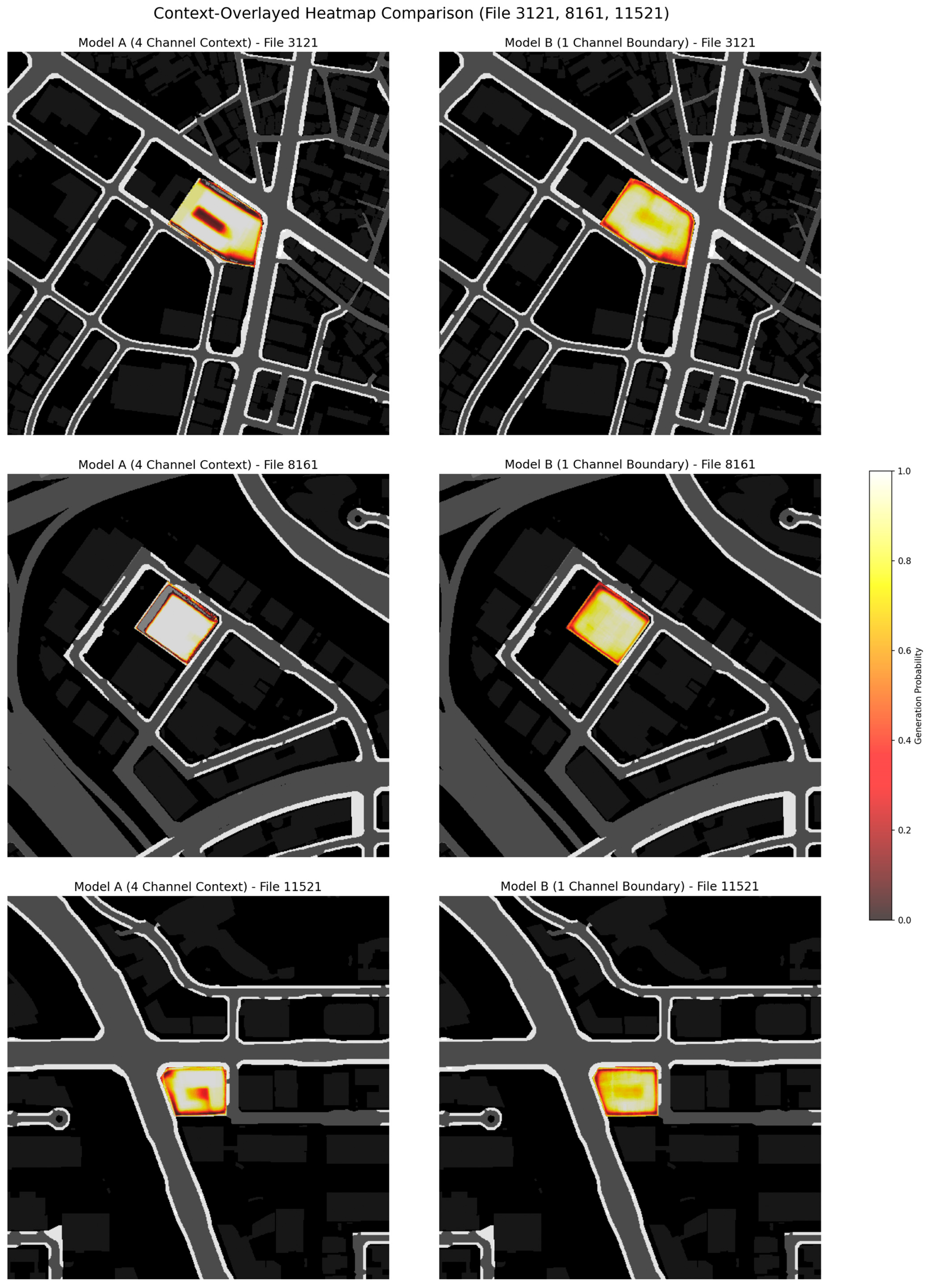
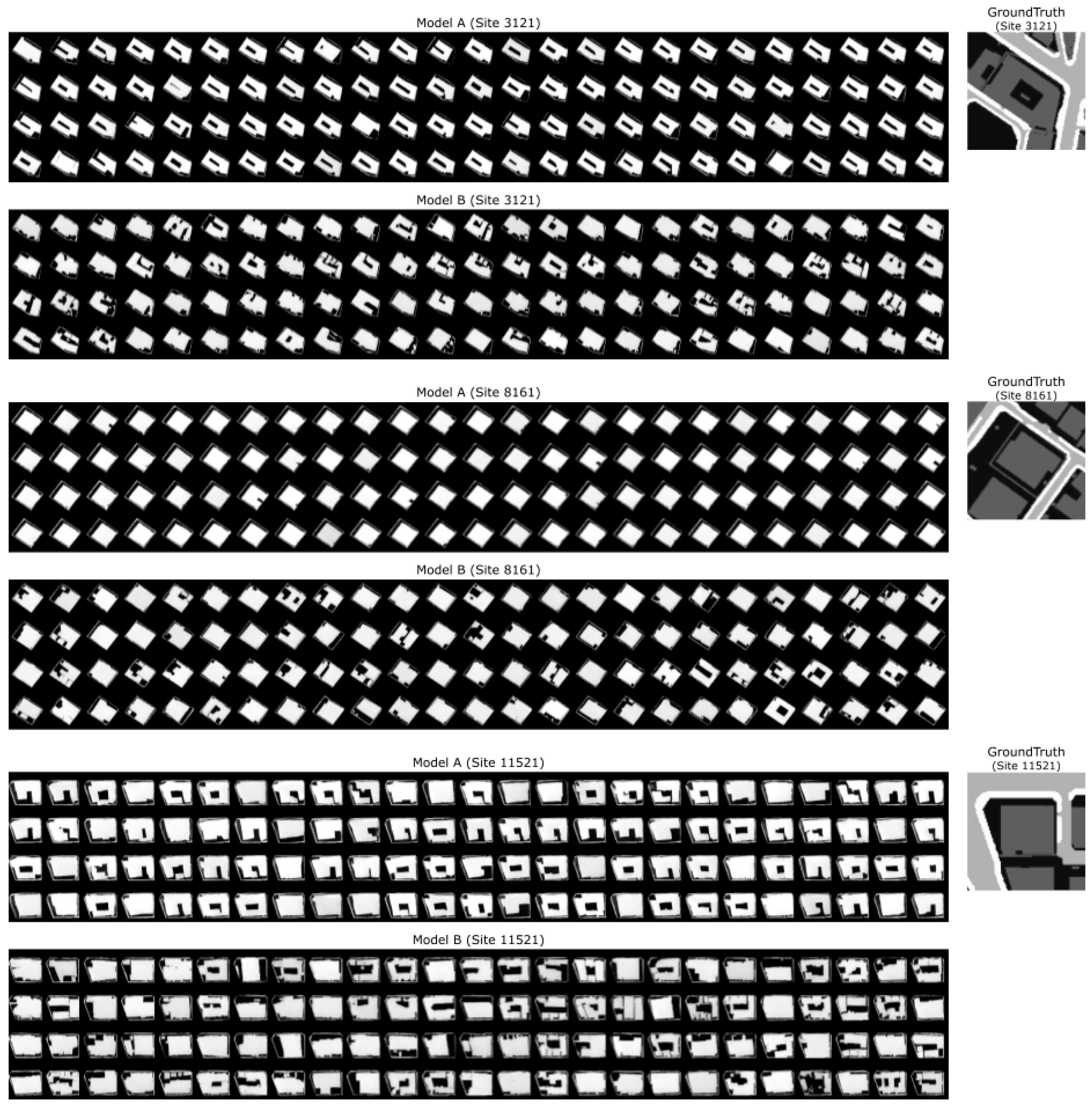
Figure 6 and
Figure 7 present the results for three test sites, illustrating differences in morphological convergence patterns determined by the amount of site information. The color gradient in
Figure 7 indicates the frequency of footprint generation at each pixel, representing the normalized frequency of footprint occurrence. Black indicates areas with a low probability of footprint placement, red represents intermediate frequencies, whereas white denotes areas where the model most consistently generates building footprints.
The comparison model, Model B, shows a broader and more diffuse distribution of generated footprints across the site relative to Model A, as it lacks sufficient physical cues beyond the site boundary to guide form determination. This result suggests that the model is less capable of localizing appropriate placement regions for footprints and consequently exhibits higher stochastic variability.
In contrast, the proposed model, Model A, shows a more concentrated distribution of generated footprints in response to explicit contextual information such as roads and adjacent buildings. The heatmaps indicate that footprint occurrences cluster more distinctly within specific regions. This suggests that Model A demonstrates a stronger capacity to incorporate spatial relationships with roads and neighboring buildings, thereby distinguishing more effectively between buildable zones and areas that should remain unoccupied.
These visual results indicate that richer contextual information functions as an effective guideline that constrains the generative process, thereby enabling the creation of forms that are contextually coherent and spatially appropriate. Consequently, such context-aware spatial configurations may contribute to more efficient land use and improved environmental performance by promoting appropriate building placement and coherent spatial organization.
5.1.2. Mean Pixel-Wise Entropy
The pixel-wise mean entropy was measured across 15 test sites. As shown in
Table 1, Model A records lower entropy values than Model B in all cases. The overall average entropy of Model B is 5.30 bits, whereas Model A achieves 4.34 bits, corresponding to an entropy reduction of approximately 18.08%.
This quantitative difference suggests that as richer and more informative site context is provided, the model establishes stronger structural grounding for form derivation, thereby tending to converge toward contextually appropriate configurations. In other words, the proposed four-channel contextual information injection effectively regulates generative uncertainty and mitigates stochastic variability, resulting in designs that exhibit greater spatial conformity with the surrounding environment.
5.1.3. Geometric Validity via Intersection over Union
To assess whether the previously observed reduction in information entropy corresponds to geometric validity, the Intersection over Union (IoU) metric was introduced. While generative models inherently explore diverse plausible alternatives rather than replicating a single deterministic solution, comparing the model’s average generative tendency (heatmap) with the Ground Truth (GT) building data provides an approximate indicator of context-responsiveness, while acknowledging that the GT does not represent a unique optimal solution but rather a plausible realization under given site constraints.
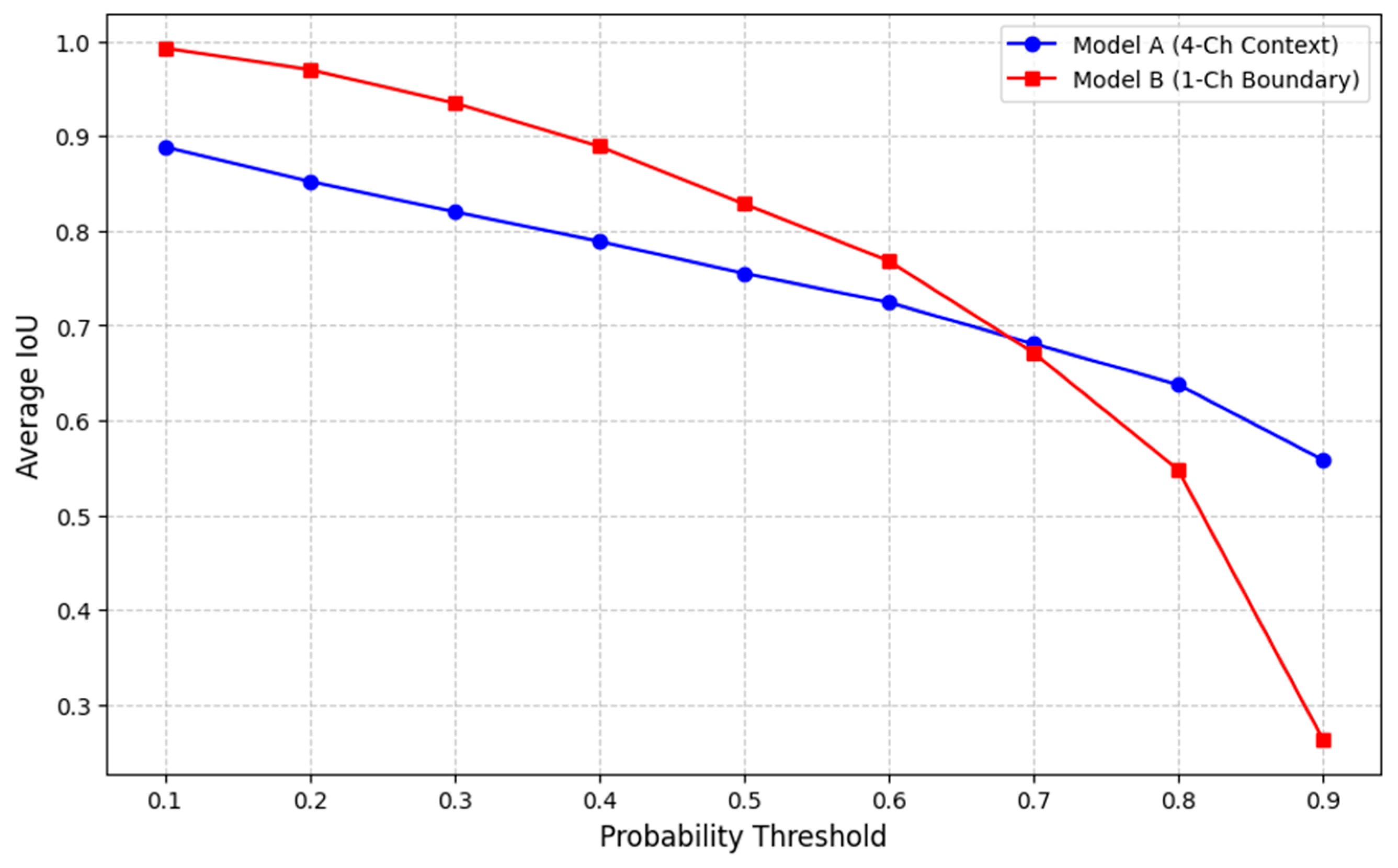
In this study, a trend analysis was conducted by gradually increasing the probability threshold applied to the normalized heatmaps from 0.1 to 0.9 to derive binary masks, which were then compared with the GT mask. The IoU is defined as the ratio of the intersection area to the union area between the two masks [
45]. As shown in
Figure 8, in the relatively low threshold range between 0.1 and 0.6, the IoU of the comparison model (Model B) is higher than that of the proposed model (Model A). This occurs because Model B, while constrained by the site boundary, lacks surrounding contextual information and thus exhibits higher stochastic variability, producing spatially diffuse footprint distributions within the site boundary. As a result, when a low threshold is applied, an overestimation of building regions occurs, leading to increased overlap with the GT partially due to stochastic coincidence.
However, as the threshold enters the high-threshold region (above 0.6), this pattern reverses, and the IoU of Model A becomes higher than that of Model B. Notably, as the threshold approaches 0.9, the IoU of Model B decreases sharply, resulting in fragmented or diminished footprint regions, whereas Model A shows a more gradual decline and maintains coherent geometric structures. These results suggest that, compared to Model B, Model A not only reduces generative uncertainty but also produces high-confidence regions that more closely align with plausible architectural layouts under given site constraints. This indicates that the incorporation of richer contextual information helps guide the generative process toward geometrically consistent and context-responsive spatial configurations.
5.2. Qualitative Analysis
To interpret what the geometric convergence identified in the preceding quantitative analysis signifies in terms of architectural morphology, this study introduces three qualitative evaluation criteria. These criteria are grounded in architectural and urban morphology theories and provide a structured framework for examining how the generated outcomes reflect the physical context of the site. The underlying principles of each criterion are as follows:
Geometric Alignment with the Public Street Edge: Buildings are expected to contribute to the definition of public urban space by forming coherent and continuous boundaries along adjacent street networks [
46,
47].
Morphological Modulation with Adjacent Buildings: Drawing on the concept of “locus,” which emphasizes contextual continuity, buildings are expected to adjust their placement—through setbacks or alignments—in response to the geometric presence of neighboring structures [
1].
Spatial Differentiation of Public and Private Domains: Urban space is characterized by a fundamental distinction between public and private domains, and the plot system plays a key role in structuring this relationship [
46].
Based on these criteria, the spatial occupancy density heatmaps of selected test sites (Sites 3121, 8161, and 11,521) (
Figure 6 and
Figure 7), generated by the proposed Model A and the baseline Model B, were comparatively analyzed.
For Site 3121, the parcel is bounded by roads on all sides except the left, with major roads located on the top and right, and a minor road on the bottom, while an existing building is located on the left. Under Criterion 1, Model A exhibits a clear linear alignment parallel to the top and right major roads, whereas Model B shows weaker linearity. Under Criterion 2, Model A reflects the adjacent context by maintaining a distinct setback consistent with the position of the neighboring building on the left, whereas this relationship is less clearly observed in Model B. Regarding Criterion 3, given that the site is largely exposed to public roads, the private domain is expected to be located toward the left or central area. Model A shows a stronger tendency to form a central courtyard, whereas Model B tends to fill the central area without forming a courtyard.
Site 8161 is characterized by a setback road condition on the top-left and a rectangular adjacent building on the bottom-left, with minor roads along the top-right and bottom-right edges. Under Criterion 1, Model A exhibits alignment with the surrounding street geometry, whereas Model B shows comparatively weaker alignment. Under Criterion 2, Model A reflects the geometry of the adjacent building by maintaining a corresponding setback, whereas this effect is less evident in Model B. However, Criterion 3, which relates to the differentiation of public and private domains, is not strongly expressed in either model for this site.
Site 11,521 is a trapezoidal parcel bordered by major roads on the top and left, a minor road on the right, and an adjacent building on the bottom. Under Criteria 1 and 2, both models show limited linear alignment, with a tendency to follow the geometry of the adjacent building. However, given that the site is exposed to roads on three sides, the most private domain is expected to be located toward the bottom. Criterion 3 reveals that Model A exhibits a stronger tendency to form a courtyard in this region, whereas this tendency is less pronounced in Model B.
These qualitative results, based on criteria derived from architectural and urban morphology theories, suggest that Model A more effectively incorporates site context than Model B. The multi-channel contextual input enables the model to reflect key morphological features—such as street alignment, building setbacks, and the organization of private open spaces—thereby enhancing the architectural plausibility of the generated footprints.
6. Conclusions
This study sought to overcome the limitations of existing generative AI-based design approaches, which often fail to meaningfully incorporate site context as a fundamental condition of architectural design. To address this issue, a context-responsive footprint generation methodology was proposed based on conditional inpainting using a latent diffusion model (LDM).
The primary contribution of this research lies in the construction of a four-channel contextual representation—sidewalks, roadways, adjacent buildings, and site boundaries—and in the quantitative and qualitative verification of its effectiveness as a control factor in regulating generative uncertainty. The ablation study demonstrated that the proposed four-channel model reduced the average pixel-wise information entropy by 18.08% (0.96 bits) compared with the single-channel model.
These findings suggest that as richer and more informative contextual information is provided, the model achieves stronger contextual grounding in form derivation. Consequently, it tends to move beyond stochastic variability and generate design outcomes that more closely reflect the spatial order of the surrounding environment. This further implies that reducing generative uncertainty by utilizing site information can mitigate potential discordance at the early design stage. These findings indicate that utilizing site information to reduce generative uncertainty can establish a geometrically coherent and context-responsive starting point for early-stage design. While further quantitative assessment is required to evaluate its direct impact on urban performance, such context-aware spatial configuration may serve as a morphological foundation for subsequent optimization processes targeting sustainable land utilization and urban environmental goals. However, several limitations of the present study should be acknowledged. The current dataset is primarily composed of geometrically regular urban fabrics, which may limit the generalization of the proposed model to more complex and organically developed urban environments. In addition, the experimental design is limited to a single ablation setting, and further studies incorporating intermediate configurations and comparisons with alternative approaches would be beneficial for a more comprehensive assessment of the contribution of the proposed framework. Future work will therefore focus on expanding the dataset to include more diverse urban conditions and conducting more extensive comparative evaluations.
Although the proposed framework has shown meaningful improvements in contextual coherence, practical implementation in architectural workflows still requires further technical refinement. From a technical perspective, the current model generates raster-based bitmap outputs, which limits immediate compatibility and editability within standard CAD/BIM environments commonly used in professional practice. Accordingly, future research may focus on enhancing post-processing pipelines that convert generated pixel-based representations into refined vector data. Alternatively, subsequent studies could investigate vector-based diffusion models capable of directly generating geometrically structured and topologically connected architectural elements during the learning phase. In addition, enabling advanced geometric reasoning requires the continuous acquisition of high-quality training datasets that accurately reflect expert design intent and spatial logic.
Beyond these technical challenges, this study raises a broader, long-term question regarding the integration of currently fragmented AI design processes. At present, most generative design research addresses site analysis, massing, and floor planning through independently trained models, resulting in a segmented workflow that limits continuous feedback across design stages. Future research should therefore focus on establishing an end-to-end design framework in which each stage is seamlessly interconnected.
In such an integrated system, contextual information would inform massing decisions; the derived mass would, in turn, influence internal spatial organization; and subsequent stages—such as building systems coordination and furniture layout—would be optimized in a continuous, cascading manner. Such an integrated approach may contribute to repositioning AI from a tool for partial automation toward a more comprehensive form of design intelligence. From this perspective, AI could potentially support architects’ professional reasoning processes across multiple stages of design, from early planning to detailed development.
Author Contributions
Conceptualization, E.J. and K.K.; methodology, E.J. and K.K.; software, E.J.; validation, E.J. and K.K.; formal analysis, E.J.; investigation, E.J.; data curation, E.J.; writing—original draft preparation, E.J.; writing—review and editing, E.J. and K.K.; visualization, E.J.; supervision, K.K.; funding acquisition, K.K. All authors have read and agreed to the published version of the manuscript.
Funding
This paper was supported by Konkuk University in 2024.
Institutional Review Board Statement
Not applicable.
Informed Consent Statement
Not applicable.
Data Availability Statement
Conflicts of Interest
The authors declare no conflicts of interest.
Abbreviations
The following abbreviations are used in this manuscript:
| LDM | Latent Diffusion Model |
| VAE | Variational Autoencoder |
References
- Rossi, A. The Architecture of the City; MIT Press: Cambridge, MA, USA, 1984. [Google Scholar]
- Rowe, C.; Koetter, F. Collage City; MIT Press: Cambridge, MA, USA, 1984. [Google Scholar]
- LaGro, J.A., Jr. Site Analysis: Informing Context-Sensitive and Sustainable Site Planning and Design; John Wiley & Sons: Hoboken, NJ, USA, 2013. [Google Scholar]
- Bibri, S.E.; Krogstie, J.; Kärrholm, M. Compact city planning and development: Emerging practices and strategies for achieving the goals of sustainability. Dev. Built Environ. 2020, 4, 100021. [Google Scholar] [CrossRef] [Scilit]
- Sharifi, A. From Garden City to Eco-urbanism: The quest for sustainable neighborhood development. Sustain. Cities Soc. 2016, 20, 1–16. [Google Scholar] [CrossRef] [Scilit]
- Yigitcanlar, T.; Kamruzzaman, M.; Foth, M.; Sabatini-Marques, J.; Da Costa, E.; Ioppolo, G. Can cities become smart without being sustainable? A systematic review of the literature. Sustain. Cities Soc. 2019, 45, 348–365. [Google Scholar] [CrossRef] [Scilit]
- Trancik, R. Finding Lost Space: Theories of Urban Design; John Wiley & Sons: Hoboken, NJ, USA, 1991. [Google Scholar]
- Burton, E. The compact city: Just or just compact? A preliminary analysis. Urban Stud. 2000, 37, 1969–2006. [Google Scholar] [CrossRef] [Scilit]
- Jang, S.; Roh, H.; Lee, G. Generative AI in architectural design: Application, data, and evaluation methods. Autom. Constr. 2025, 174, 106174. [Google Scholar] [CrossRef] [Scilit]
- Chaillou, S. Archigan: Artificial intelligence x architecture. In Architectural Intelligence: Selected Papers from the 1st International Conference on Computational Design and Robotic Fabrication (CDRF 2019); Springer Nature: Singapore, 2020; pp. 117–127. [Google Scholar]
- Rhee, J.; Veloso, P.; Krishnamurti, R. Integrating building footprint prediction and building massing: An experiment in Pittsburgh. In RE: ANTROPOCENE: In Proceedings of the 25th International Conference of the Association for Computer-Aided Architectural Design Research in Asia (CAADRIA); Association for Computer-Aided Architectural Design Research in Asia (CAADRIA): Hong Kong, China, 2020; Volume 2, pp. 669–678. [Google Scholar]
- Wu, J.; Bernhard, M.; Li, L.; Savov, A.; Dillenburger, B. DeepCanvas: Sequential design strategy acquisition in context-aware building footprint synthesis using vision-based deep reinforcement learning. Front. Archit. Res. 2025, in press. [Google Scholar] [CrossRef] [Scilit]
- Jabareen, Y.R. Sustainable urban forms: Their typologies, models, and concepts. J. Plan. Educ. Res. 2006, 26, 38–52. [Google Scholar] [CrossRef] [Scilit]
- Ratti, C.; Baker, N.; Steemers, K. Energy consumption and urban texture. Energy Build. 2005, 37, 762–776. [Google Scholar] [CrossRef] [Scilit]
- Stiny, G.; Gips, J. Shape grammars and the generative specification of painting and sculpture. In Proceedings of the IFIP Congress, Ljubljana, Yugoslavia, 23–28 August 1971; Volume 2, pp. 125–135. [Google Scholar]
- Müller, P.; Wonka, P.; Haegler, S.; Ulmer, A.; Van Gool, L. Procedural modeling of buildings. In Proceedings of the ACM SIGGRAPH 2006 Papers, Boston, MA, USA, 30 July–3 August 2006; Association for Computing Machinery: New York, NY, USA, 2006; pp. 614–623. [Google Scholar]
- Chaillou, S. AI + Architecture: Towards a New Approach; Harvard University: Cambridge, MA, USA, 2019. [Google Scholar]
- Sönmez, N.O. A review of the use of examples for automating architectural design tasks. Comput.-Aided Des. 2018, 96, 13–30. [Google Scholar] [CrossRef] [Scilit]
- Haakonsen, S.M.; Rønnquist, A.; Labonnote, N. Fifty years of shape grammars: A systematic mapping of its application in engineering and architecture. Int. J. Archit. Comput. 2023, 21, 5–22. [Google Scholar] [CrossRef] [Scilit]
- Park, S.M. Tall Building form Generation by Parametric Design Process; Illinois Institute of Technology: Chicago, IL, USA, 2005. [Google Scholar]
- Caldas, L.G.; Norford, L.K. A design optimization tool based on a genetic algorithm. Autom. Constr. 2002, 11, 173–184. [Google Scholar] [CrossRef] [Scilit]
- Wang, L.; Janssen, P.; Ji, G. Optimization-based design exploration of building massing typologies—EvoMass and a typology-oriented computational design optimization method for early-stage performance-based building massing design. Front. Archit. Res. 2024, 13, 1400–1422. [Google Scholar] [CrossRef] [Scilit]
- Li, S.; Liu, L.; Peng, C. A review of performance-oriented architectural design and optimization in the context of sustainability: Dividends and challenges. Sustainability 2020, 12, 1427. [Google Scholar] [CrossRef] [Scilit]
- Li, C.; Zhang, T.; Du, X.; Zhang, Y.; Xie, H. Generative AI models for different steps in architectural design: A literature review. Front. Archit. Res. 2025, 14, 759–783. [Google Scholar] [CrossRef] [Scilit]
- Zhuang, J.; Li, G.; Xu, H.; Xu, J.; Tian, R. Text-to-city controllable 3d urban block generation with latent diffusion model. In Proceedings of the 29th International Conference of the Association for Computer-Aided Architectural Design Research in Asia (CAADRIA), Singapore, 20–25 April 2024; pp. 20–26. [Google Scholar]
- Liu, Y.; Li, H.; Deng, Q.; Hu, K. Diffusion probabilistic model assisted 3D form finding and design latent space exploration: A case study for taihu stone spacial transformation. In Proceedings of the International Conference on Computational Design and Robotic Fabrication; Springer Nature: Singapore, 2023; pp. 11–23. [Google Scholar]
- Zeng, P.; Gao, W.; Yin, J.; Xu, P.; Lu, S. Residential floor plans: Multi-conditional automatic generation using diffusion models. Autom. Constr. 2024, 162, 105374. [Google Scholar] [CrossRef] [Scilit]
- Shabani, M.A.; Hosseini, S.; Furukawa, Y. Housediffusion: Vector floorplan generation via a diffusion model with discrete and continuous denoising. In Proceedings of the IEEE/CVF Conference on Computer Vision and Pattern Recognition, Vancouver, BC, Canada, 18–22 June 2023; IEEE: New York, NY, USA, 2023; pp. 5466–5475. [Google Scholar]
- Dhariwal, P.; Nichol, A. Diffusion models beat gans on image synthesis. Adv. Neural Inf. Process. Syst. 2021, 34, 8780–8794. [Google Scholar]
- Zhuang, X.; Ju, Y.; Yang, A.; Caldas, L. Synthesis and generation for 3D architecture volume with generative modeling. Int. J. Archit. Comput. 2023, 21, 297–314. [Google Scholar] [CrossRef] [Scilit]
- Schrijver, L. Oswald Mathias Ungers and Rem Koolhaas: Recalibrating Architecture in the 1970s; Transcript Verlag: Bielefeld, Germany, 2021; Volume 63. [Google Scholar]
- Ching, F.D.K. Architecture: Form, Space, and Order, 3rd ed.; John Wiley & Sons: Hoboken, NJ, USA, 2007. [Google Scholar]
- Rombach, R.; Blattmann, A.; Lorenz, D.; Esser, P.; Ommer, B. High-resolution image synthesis with latent diffusion models. In Proceedings of the IEEE/CVF Conference on Computer Vision and Pattern Recognition, New Orleans, LA, USA, 19–24 June 2022; IEEE: New York, NY, USA, 2022; pp. 10684–10695. [Google Scholar]
- Kingma, D.P.; Welling, M. Auto-encoding variational bayes. arXiv 2013, arXiv:1312.6114. [Google Scholar]
- Esser, P.; Rombach, R.; Ommer, B. Taming transformers for high-resolution image synthesis. In Proceedings of the IEEE/CVF Conference on Computer Vision and Pattern Recognition, Virtual Conference, 19–25 June 2021; IEEE: New York, NY, USA, 2021; pp. 12873–12883. [Google Scholar]
- Ronneberger, O.; Fischer, P.; Brox, T. U-net: Convolutional networks for biomedical image segmentation. In Proceedings of the International Conference on Medical Image Computing and Computer-Assisted Intervention; Springer International Publishing: Cham, Switzerland, 2015; pp. 234–241. [Google Scholar]
- National Geographic Information Institute. National Spatial Information Platform. Available online: https://map.ngii.go.kr/ (accessed on 20 April 2025).
- QGIS Geographic Information System, version 3.38.2; QGIS Association: Grüt, Switzerland, 2024; Available online: https://www.qgis.org (accessed on 20 April 2025).
- Shorten, C.; Khoshgoftaar, T.M. A survey on image data augmentation for deep learning. J. Big Data 2019, 6, 60. [Google Scholar] [CrossRef] [Scilit]
- Ho, J.; Salimans, T. Classifier-free diffusion guidance. arXiv 2022, arXiv:2207.12598. [Google Scholar] [CrossRef] [Scilit]
- Sejnowski, T.J.; Rosenberg, C.R. Parallel networks that learn to pronounce English text. Complex Syst. 1987, 1, 145–168. [Google Scholar]
- Nazarnia, N.; Harding, C.; Jaeger, J.A. How suitable is entropy as a measure of urban sprawl? Landsc. Urban Plan. 2019, 184, 32–43. [Google Scholar] [CrossRef] [Scilit]
- Shannon, C.E. A mathematical theory of communication. Bell Syst. Tech. J. 1948, 27, 379–423. [Google Scholar] [CrossRef] [Scilit]
- Zhang, L.; Rao, A.; Agrawala, M. Adding conditional control to text-to-image diffusion models. In Proceedings of the IEEE/CVF International Conference on Computer Vision, Paris, France, 2–6 October 2023; IEEE: New York, NY, USA, 2023; pp. 3836–3847. [Google Scholar]
- Kim, K.; Kim, K.; Jeong, S. Application of YOLO v5 and v8 for recognition of safety risk factors at construction sites. Sustainability 2023, 15, 15179. [Google Scholar] [CrossRef] [Scilit]
- Krier, R.; Rowe, C. Urban Space; Academy Editions: London, UK, 1979; p. 17. [Google Scholar]
- de Oliveira, A. Urban Morphology; Springer International Publishing: Berlin/Heidelberg, Germany, 2022. [Google Scholar]
| Disclaimer/Publisher’s Note: The statements, opinions and data contained in all publications are solely those of the individual author(s) and contributor(s) and not of MDPI and/or the editor(s). MDPI and/or the editor(s) disclaim responsibility for any injury to people or property resulting from any ideas, methods, instructions or products referred to in the content. |