Review

A Conceptual Decision-Support Agent-Based Framework for Evacuation Planning Under Compound Hazards

by
Omar Bustami
,
Francesco Rouhana
* and
Amvrossios Bagtzoglou
*
School of Civil and Environmental Engineering, University of Connecticut, Storrs, CT 06269, USA
*
Authors to whom correspondence should be addressed.
Sustainability 2026, 18(8), 3658; https://doi.org/10.3390/su18083658
Submission received: 1 March 2026 / Revised: 2 April 2026 / Accepted: 5 April 2026 / Published: 8 April 2026
(This article belongs to the Special Issue Sustainable Disaster Management and Community Resilience)

Abstract

Evacuation planning is increasingly challenged by compound hazards in which interacting threats degrade infrastructure, influence human behavior, and destabilize transportation systems. Although agent-based models and dynamic traffic simulations have advanced substantially, much of the evacuation literature remains hazard-specific, case-bound, or difficult to transfer across regions. In parallel, transportation resilience research shows that multi-hazard effects are often non-additive and that cascading infrastructure failures can amplify disruption beyond directly affected areas, raising important sustainability concerns related to community safety, infrastructure continuity, social equity, and long-term planning capacity. These realities motivate the development of evacuation modeling frameworks that are modular, adaptable, and capable of representing co-evolving behavioral and network processes under compound hazard conditions. This review synthesizes advances in evacuation agent-based modeling, dynamic traffic assignment, hazard-induced network degradation, and compound disaster research to propose an adaptable compound-hazard evacuation framework integrating three interdependent layers: hazard processes, transportation network dynamics, and agent decision-making. The proposed framework is organized around four principles: (1) modular hazard representation, (2) decoupling behavioral decision logic from hazard physics, (3) dynamic network state evolution, and (4) neighborhood-scale performance metrics. To support sustainable and equitable local planning, the framework prioritizes spatially resolved outputs, including neighborhood clearance time, isolation probability, accessibility loss, and shelter demand imbalance. By emphasizing modularity, configurability, and policy-relevant metrics, this review connects methodological advances in evacuation modeling to the broader sustainability goals of resilient infrastructure systems, inclusive disaster risk reduction, and locally informed emergency planning.

1. Introduction

Extreme events are increasingly characterized not by isolated hazards, but by overlapping and interacting disruptions that strain physical infrastructure, social systems, and emergency management capacity [1,2,3]. Hurricanes, for example, combine wind, storm surge, and inland flooding and can generate non-additive impacts on transportation and power systems [4,5]. Wildfires can coincide with smoke-induced visibility loss, roadway blockages, and power shutoffs, producing rapidly evolving constraints on mobility and situational awareness [6,7]. Earthquakes can similarly trigger debris accumulation, bridge damage, and cascading utility failures that alter network accessibility during evacuation [8,9,10]. Under these compound conditions, planning approaches that treat hazards independently or assume static infrastructure availability are increasingly misaligned with contemporary risk realities [11,12].
Evacuation remains one of the most consequential protective actions available to emergency managers when implemented in a timely manner, reducing mortality, injury, and exposure [13,14]. However, evacuation outcomes emerge from interacting behavioral and infrastructural processes. Decisions to leave depend on risk perception, trust in authorities, household constraints, prior experience, and social influence [15,16,17]. Once departures begin, transportation networks experience sharp demand surges that may exceed capacity, particularly when infrastructure is simultaneously degraded by hazard impacts [18,19,20]. In hurricane contexts, variation in compliance and route choice can substantially alter congestion formation and clearance times [21,22], while wildfire studies show that limited vehicle access, delayed awareness, and fast-changing hazard conditions can produce critical bottlenecks [23]. These findings highlight the need for evacuation models that capture feedback among household decisions, network dynamics, and hazard-driven disruption.
Over the past two decades, evacuation modeling has advanced substantially [24,25,26]. Agent-based models (ABMs) support representation of heterogeneous households [27], probabilistic departure timing [17], adaptive rerouting [28], and congestion feedback mechanisms [3]. Dynamic traffic assignment approaches further capture time-varying demand and spillback effects that static clearance calculations cannot reproduce [29,30]. In parallel, hazard modeling has improved representations of inundation extents, debris blockages, fire spread, and network fragility, while transportation resilience research has shown that multi-hazard effects are often not additive and may differ qualitatively from single-hazard analyses [1,2,31].
Despite this progress, three structural gaps remain. First, many evacuation models are designed for specific hazards or case studies, with hazard physics embedded directly into scenario assumptions and network representations (e.g., hard-coded flood rasters, wildfire perimeters, or debris ratios), limiting usability across hazards/regions with minimal re-engineering. Second, behavioral decision logic and hazard representation are frequently intertwined, making it difficult to adapt models across contexts without substantial recalibration or redesign. Third, performance is commonly summarized with aggregate measures such as total clearance time or average travel duration, which can obscure localized vulnerabilities and distributional inequities. These limitations are amplified under compound hazards, where interacting disruptions and cascading service failures can reshape accessibility beyond directly damaged zones [11,32,33,34] and degrade travel time reliability disproportionately relative to simple connectivity metrics [35,36]. Simultaneously, municipal decision environments demand tools that are transparent, configurable, and aligned with operational questions such as evacuation order timing, shelter placement, route prioritization, and contingency planning across plausible scenarios. Decision support systems have been developed to support routing and shelter allocation [37,38,39], yet many remain tailored to specific contexts or require specialized expertise that can limit routine use.
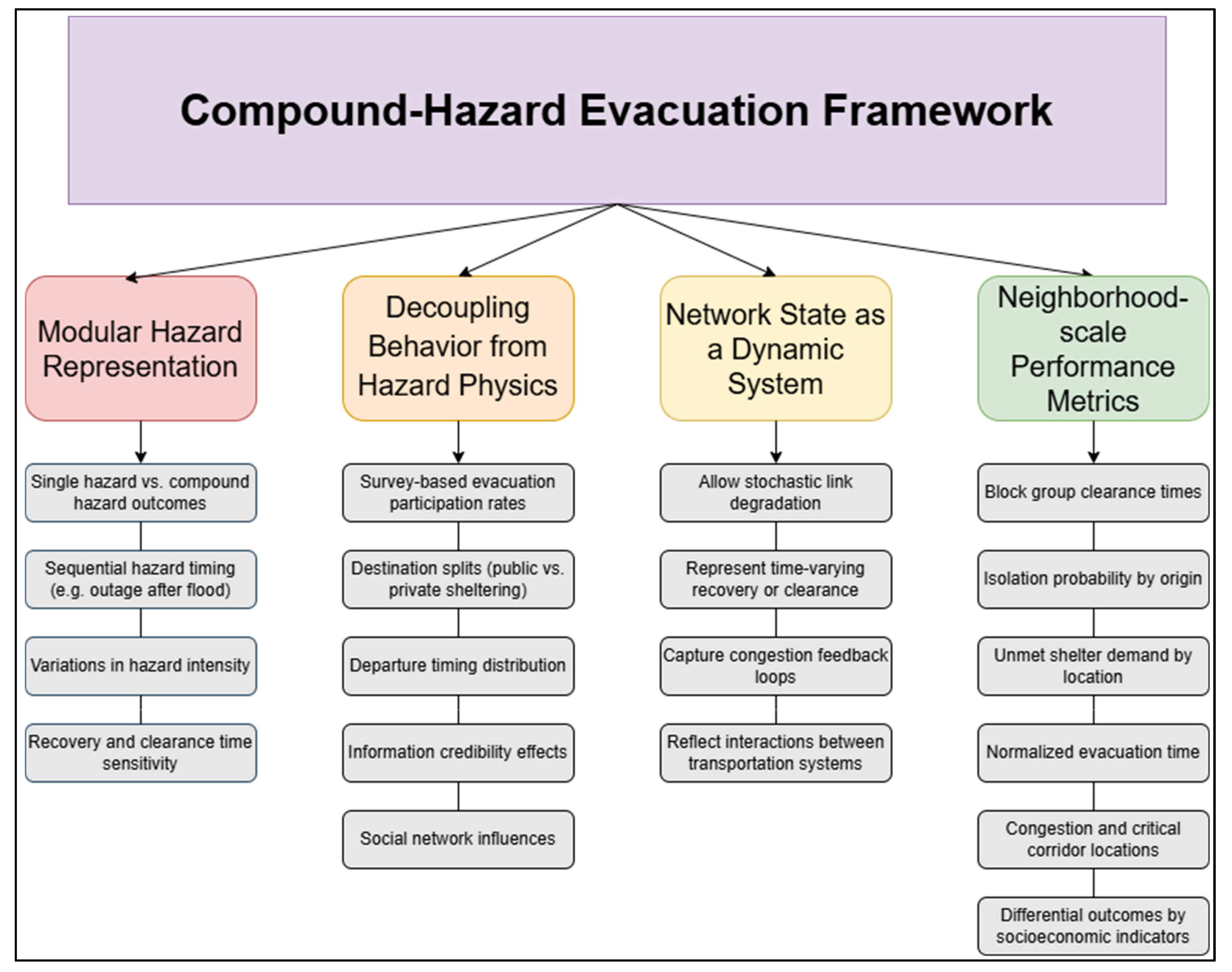
This review proposes an adaptable, modular compound-hazard evacuation framework that synthesizes existing methodological strands into a coherent architecture organized around four principles: (1) modular hazard representation, (2) decoupling of behavioral decision logic from hazard physics, (3) dynamic network state evolution, and (4) neighborhood-scale performance metrics. The framework is intentionally hazard-agnostic, allowing wind, flood, wildfire, seismic debris, or other disruptions to be incorporated as interchangeable modules that affect capacity, speed, or accessibility through scenario-based or probabilistic processes, while preserving consistent behavioral structures for departure timing, destination choice, and rerouting. The review has two objectives: (O1) to synthesize advances in evacuation ABMs, shelter system modeling, dynamic traffic assignment, compound disaster research, and transportation network resilience to identify design requirements for adaptable modeling; and (O2) to articulate how a modular architecture can support multi-hazard evacuation planning across regions with differing risk profiles. The contribution is a conceptual structure that improves methodological coherence while supporting policy relevance of evacuation modeling under compound impacts.

2. Analytical Framework

This study adopts a structured narrative review and conceptual synthesis approach to examine evacuation modeling literature and develop an integrated framework for compound hazard evacuation analysis. The review focuses on the intersection of agent-based modeling (ABMs), transportation network dynamics, hazard-induced infrastructure degradation, and evacuation behavior under multi-hazard conditions. Rather than conducting a formal systematic review, the objective is to synthesize representative and influential studies across these domains to support framework development and identify key modeling limitations.
The literature base was compiled using targeted keyword searches across major academic databases, including Google Scholar, Scopus, Web of Science, and IEEE Xplore, supplemented by government reports and technical documents from agencies such as FEMA and NOAA. Core search terms included combinations of “evacuation modeling,” “agent-based model,” “hurricane evacuation,” “dynamic traffic assignment,” “transportation network disruption,” “compound hazards,” “storm surge,” “infrastructure failure,” and “evacuation behavior.” Additional terms related to equity and vulnerability (e.g., “social vulnerability,” “vehicle access,” “evacuation inequality”) were included to capture studies addressing differential outcomes across populations.
The initial search identified over 240 publications. A two-stage screening process was applied to refine the literature set. First, titles and abstracts were reviewed to assess relevance to evacuation modeling, hazard interaction, or infrastructure disruption. Second, full-text review was conducted to evaluate each source based on its contribution to one or more of the following themes: (i) behavioral modeling of evacuation decision-making, (ii) traffic dynamics and network performance, (iii) hazard representation and infrastructure impacts, and (iv) equity and socioeconomic considerations in evacuation outcomes. Following screening and consolidation, 158 sources were retained and organized thematically to support the development of the proposed framework.
The selected literature spans multiple hazards (e.g., hurricanes, floods, wildfires), modeling paradigms (e.g., ABMs, mesoscopic and macroscopic traffic models), and spatial scales, with particular emphasis on studies relevant to coastal evacuation and compound hazard conditions. The synthesis prioritizes studies that provide methodological insight, empirical grounding, or practical relevance for evacuation planning. This approach enables the integration of diverse modeling perspectives while maintaining a clear focus on framework development and application to local decision-making contexts.

3. Behavioral and Network Mechanisms in Evacuation ABMs

Agent-based models (ABMs) conceptualize evacuation not as an aggregate flow problem but as an emergent outcome of interacting decision-makers whose behavior evolves with changing environmental conditions and network performance. This perspective has become a dominant paradigm for representing evacuation as a decentralized, adaptive process embedded within dynamic infrastructure systems. Over the past decade, ABM-based evacuation research has matured substantially, incorporating richer behavioral adaptation, congestion formation, and hazard exposure mechanisms [3,25,28]. However, the increasing sophistication of individual components has not always been matched by system-level architectural coherence [30]. As behavioral, traffic, shelter, and hazard modules advance in parallel, integration, transferability, and consistency become central design concerns. This section reviews the behavioral and network foundations of evacuation ABMs and emphasizes how these elements can be organized in a unified, modular structure capable of supporting compound-hazard analysis.
A defining contribution of evacuation ABMs is their ability to represent behavioral heterogeneity within system-level simulations [40,41]. Across hazard contexts, evidence consistently shows that evacuation outcomes are highly sensitive to departure timing, risk perception, information exchange, compliance dynamics, and mobility constraints [42,43]. Evacuees are not passive users of infrastructure; staggered departures, adaptive rerouting, and socially mediated compliance reshape congestion and accessibility in ways that feed back into subsequent decisions. Wildfire simulations illustrate how delayed awareness and limited vehicle access can amplify exposure [23,44], while integrated fire-traffic models demonstrate how hazard propagation can alter route viability in real time [45,46]. Similar sensitivities occur in tsunami, landslide, and technological hazards, where small changes in participation or departure timing can generate disproportionate shifts in congestion and survival outcomes [47,48,49]. Architecturally, these findings imply that behavioral modules must remain flexible under uncertainty while avoiding hazard-specific assumptions that reduce adaptability [50].
Recent modeling developments extend beyond simple decision rules to represent cognitive, physiological, and strategic dimensions of evacuation behavior. Agents are increasingly treated as adaptive entities whose movement speed, spacing, and route choice evolve under perceived threat, social contagion, and stress amplification [51,52]. Motion dynamics increasingly incorporate acceleration variability, collision avoidance, and density-dependent interactions, enabling crowd behavior to emerge from micro-scale heterogeneity rather than imposed flow assumptions [53,54]. Demographic diversity further recognizes systematic variation in mobility, response delay, and assistance needs across age groups and physical abilities, with nontrivial consequences for system performance [27]. In parallel, strategic modeling introduces probabilistic learning and game-theoretic reasoning, enabling agents to anticipate congestion, revise expectations, and adapt to evolving network states [55,56]. From an adaptable framework perspective, the key challenge is not simply adding behavioral realism, but organizing behavioral submodules so that complexity is extensible without sacrificing clarity or cross-context portability.
Model structure also matters in how uncertainty is represented. Systematic reviews report a shift away from deterministic “if–then” rules toward probabilistic decision structures that better reflect uncertainty in hazard forecasts, infrastructure availability, and social influence [25,57,58,59,60]. Behavioral research on compound emergencies further indicates that risk perception under multiple threats may diverge from single-hazard assumptions, particularly when public health, flood, or wildfire risks coincide [61,62]. This reinforces the need for behavioral architectures that can accommodate multiple concurrent signals and evolving credibility without hard-wiring hazard-specific logic into the core decision engine.
Despite advances in behavioral representation, a persistent gap remains between behavioral sophistication and empirical grounding. Many hurricane-focused ABMs reproduce large-scale traffic patterns and evacuation orders by integrating road networks, forecast cones, and evacuation zones to simulate congestion, contraflow, and demand surges [21,63,64]. Microsimulation-based optimization frameworks further enhance temporal realism by coupling dynamic programming with traffic simulation [65]. Yet behavioral inputs such as participation rates, destination splits, and departure timing, are often indirectly calibrated through socioeconomic predictors or machine learning models [66,67], with fewer studies anchoring agent decisions directly to survey-reported evacuation probabilities at meaningful spatial strata. In addition, evacuees are frequently introduced at zonal centroids rather than realistic household-to-road access points, which can mask localized bottlenecks and distort neighborhood-scale performance assessment. Thus, while ABMs capture heterogeneity conceptually, empirical and spatial specificity remains uneven across applications.
Parallel progress has occurred in representing traffic dynamics and congestion feedback. Whereas clearance-time approaches typically rely on deterministic flow assumptions and static assignments, dynamic traffic assignment frameworks incorporate time-varying demand, background traffic, rerouting behavior, and spillback [29,30]. Mesoscopic and microscopic approaches can capture queue formation, spillback, and adaptive detouring [27,68]. Research shows that communication-induced surges can intensify congestion [69] while locally rational detours may degrade system-level performance [24]. Wildfire evacuation simulations further confirm that route switching, and phased strategies can substantially alter exposure and clearance times [14,70]. These findings underscore the importance of congestion feedback mechanisms and endogenous route adaptation within evacuation models. However, many applications still report system-wide clearance time as the primary performance metric, giving less attention to spatially uneven impacts across origins or to localized isolation risks under network disruptions. This limitation is especially consequential under compound hazards, which can degrade accessibility nonuniformly across space.
Shelter modeling has also progressed from simple capacity accounting toward spatially and behaviorally informed allocation frameworks. Recent work incorporates geographic distribution, capacity constraints, and optimization routines to improve allocation efficiency and reduce exposure [71,72]. Moreover, evidence indicates that increasing shelter supply alone does not guarantee improved performance without attention to placement and accessibility [73], and evacuees’ destination choices reflect social ties, logistics, and perceived safety rather than strict proximity [74,75,76]. In system terms, shelters function as dynamic sinks whose effectiveness depends on how origin-specific demand propagates through constrained infrastructure and how behavioral decisions interact with capacity thresholds. When analyses rely primarily on system-wide occupancy totals, they risk obscuring the spatial origin of imbalances and the feedback mechanisms that generate them. Shelter modules must therefore be designed to interact explicitly with origin-resolved demand and evolving network states, enabling localized deficits to be identified without embedding hazard-specific assumptions.
Destination modeling has similarly shifted from static aggregate designs toward adaptive, context-sensitive decision structures. Early models treated destination choice as probabilistic selection among predefined alternatives conditioned on socioeconomic attributes and travel impedance [77,78], generally assuming stable hazard conditions and infrastructure availability. Subsequent work introduced temporal dynamics so preferences could evolve with changing trajectories, congestion, and accommodation constraints [79]. More recent approaches incorporate strategic anticipation and collective effects [80] and use data-driven predictors to refine spatial allocation patterns [81]. Empirical findings consistently show that income, housing tenure, and social capital shape accommodation outcomes: lower-income households and renters are more likely to rely on public shelters, while higher-income households more often evacuate to hotels or friends and relatives [16,82,83]. Structural inequality also shapes shelter reliance and post-evacuation hardship [84,85], while social networks influence both destination choice and response timing [83,86]. Prior experience, perceived shelter safety, and information credibility further mediate these patterns [15,87,88]. These results motivate destination modules that can represent both resource constraints and network-mediated social options.
Departure-time modeling has moved beyond static assumptions to incorporate adaptive learning, social influence, vulnerability, and warning system dynamics. Early work emphasized that evacuees may not optimize timing but learn and adjust based on evolving information and perceived congestion [89]. Later studies highlighted the interdependence of departure time and destination/route choices, especially in rapidly evolving hazards, motivating integrated choice structures [90,91]. Information credibility and dissemination delays have been shown to meaningfully affect participation timing [17,92]. Social vulnerability indicators have also been linked to evacuation decision latency, suggesting resource constraints and risk perception interact to delay or accelerate departure [3,93]. Although these models increasingly represent nuanced determinants of timing, socioeconomic variables are still more often used to parameterize decisions than to assess disparities in outcomes such as isolation probability, clearance time, or unmet shelter demand [94]. For compound-hazard planning, this gap is consequential because layered disruptions can differentially constrain departure feasibility across neighborhoods.
Modeling scale, validation, and usability remain central challenges. Microscopic models capture fine-grained interactions shaping evacuation time [53,95,96], while mesoscopic approaches emphasize scalability for system-level flow [97,98]. Appropriately, hybrid frameworks attempt to bridge these strengths [52,99]. Early spatial decision support systems (DSS) highlighted the value of integrating simulation with geographic information systems (GIS) for practical planning [100,101,102,103]. More recent resilience-oriented DSS work continues to stress interoperability and usability across hazards [104,105]. Methodologically, verification and validation remain challenging given behavioral uncertainty and data scarcity during extremes. Emerging approaches include virtual reality (VR)-based behavioral calibration [106], machine learning-assisted parameter tuning [107], and structured verification/validation protocols emphasizing documentation, consistency testing, sensitivity analysis, and reproducibility [108,109]. Yet for municipal planners, sophisticated engines can still appear opaque, and outputs are often reported in aggregate technical metrics rather than neighborhood-scale indicators directly usable for shelter planning, mitigation prioritization, or routine preparedness.
Overall, the literature discussed herein demonstrates that evacuation ABMs can represent heterogeneous behavior, congestion feedback, shelter allocation, and adaptive routing under hazardous conditions. However, persistent limitations remain in empirical grounding, spatial specificity, compound-hazard integration, and practitioner-facing usability. These gaps motivate modular evacuation architectures in which behavioral, network, shelter, and hazard components can be flexibly composed while producing origin-resolved, decision-ready metrics suitable for compound-hazard planning.

4. Dynamic Traffic, Network Degradation, and Evacuation Reliability

Evacuation performance emerges from the interaction between individual decision-making and transportation network dynamics. Even when behavioral rules are specified with high fidelity, evacuation outcomes depend on how departures and route choices propagate through constrained, time-varying road systems [17,24,26]. Empirical and simulation-based studies show that route switching, congestion awareness, and information exchange can either improve or degrade system performance depending on network conditions and coordination mechanisms [27,69,110]. This interaction has motivated a long-term shift in evacuation modeling away from deterministic clearance-time calculations and toward dynamic traffic assignment and agent-based traffic representations that can capture congestion formation, spillback, rerouting, and capacity constraints under evolving conditions [29,30,111,112]. Compared with aggregate clearance approaches, these models improve realism by allowing demand to vary over time, incorporating background traffic, and representing adaptive routing in response to changing network states [30,47,113,114].
Traditional clearance models estimate evacuation time primarily as a function of demand and network capacity under fixed roadway availability [39,64,115]. While useful for preliminary planning, they typically assume stable infrastructure, uniform exposure, and predictable demand patterns [47,116]. Dynamic models relax these assumptions by representing time-dependent demand, route switching, multimodal travel, and congestion feedback loops [29,30]. Agent-based or mesoscopic simulations further capture localized density effects, queue spillback, and nonlinear system responses to small behavioral shifts [27,68]. The broader modeling shift exposes a structural limitation that becomes critical under compound hazards: network availability is still often treated as exogenous and predetermined, rather than evolving probabilistically during the evacuation as hazard intensity changes [1,117]. Multi-hazard resilience research shows that infrastructure functionality can evolve nonlinearly under sequential or interacting hazards, producing outcomes that differ substantially from single-hazard estimates [10,118].
Congestion also actively reshapes decision-making, creating feedback cycles between perception, route selection, and network loading [17,26]. Information dissemination can trigger synchronized departure surges that intensify early bottlenecks [69], and locally rational detours can degrade overall system performance when agents act independently [24]. Reviews of group evacuation dynamics similarly emphasize that collective movement patterns and coordination failures can amplify congestion waves in high-stress environments [119]. These findings reinforce that evacuation networks function as adaptive socio-technical systems, where behavioral responses and traffic dynamics co-produce accessibility outcomes.
A parallel line of research emphasizes that infrastructure functionality often changes during the event itself and should be represented explicitly. Monitoring and assessment frameworks for transport infrastructure exposed to multiple hazards highlight the importance of real-time damage detection and dynamic functional evaluation [120]. Road closures, contraflow strategies, and rerouting under disrupted conditions can substantially alter clearance outcomes [121,122]. In wildfire contexts, reduced visibility, debris, and roadway temperature changes measurably affect speeds and route viability [123,124]. Foundational work argues that roadway capacity constraints and occupancy thresholds should be incorporated explicitly into community planning [125]. Hurricane evacuation studies similarly show that network performance is sensitive to dynamic shelter allocation and background traffic conditions [29]. These contributions move beyond demand–capacity calculations under fixed assumptions and motivate time-evolving representations of accessibility.
Infrastructure interdependencies further complicate this evolution. Integrated network models demonstrate that transportation systems are tightly coupled with power, communication, and water infrastructure, such that failure in one subsystem can propagate across others [126,127]. Transportation has been identified as an underestimated backbone of community resilience because disruptions in mobility constrain access to healthcare, shelter, and emergency services even when other systems remain partially functional [128]. Policy-based recovery models show that restoration sequencing and infrastructure prioritization significantly influence overall system resilience under uncertainty [129]. However, evacuation traffic models rarely integrate such interdependent restoration dynamics into simulations of ongoing population movement.
These gaps become more consequential under compound hazards. Emerging literature demonstrates that multi-hazard effects are often non-additive and that the timing and interaction of concurrent events can produce outcomes that differ substantially from single-hazard estimates [1,2]. Spatial hazard configuration also matters because resilience depends on how hazard intensity overlaps with network topology [130]. For example, flood-related road loss combined with wind-driven debris may isolate neighborhoods even when each hazard alone would not [117,131,132,133]. Transportation resilience studies further show that travel-time reliability can deteriorate disproportionately under multi-hazard stress relative to simple connectivity metrics [36], yet these insights are still rarely embedded within evacuation simulations that couple demand, routing, and disruption processes.
Cascading failures introduce additional pathways through which evacuation outcomes can diverge from single-system assumptions. Behavioral responses to evacuation orders can overload communication networks and induce flash congestion, generating nonlinear stress patterns [18,134]. Power outages may disable traffic signals and reduce effective roadway capacity precisely when evacuation demand peaks [20]. These interdependencies can expand impacts beyond the direct hazard footprint and reshape accessibility gradients across neighborhoods, yet they remain underrepresented in many operational ABMs and traffic-based evacuation models.
Taken together, the literature demonstrates substantial progress in modeling traffic dynamics, congestion feedback, rerouting, and infrastructure constraints. However, current approaches remain fragmented: behavioral models, traffic assignment models, hazard impact models, and infrastructure resilience frameworks are often developed in parallel rather than within unified architectures. As a result, many evacuation simulations remain hazard-specific, region-specific, and difficult to adapt across contexts.
This fragmentation motivates the development of a modular, adaptable compound-hazard evacuation framework. Such a framework must (1) represent hazard impacts as stochastic, time-varying processes affecting network links; (2) couple behavioral adaptation with evolving infrastructure functionality; (3) quantify neighborhood-scale performance metrics rather than only aggregate clearance times; and (4) remain adaptable to different hazard combinations, from wind–surge systems to wildfire–smoke scenarios or earthquake–landslide interactions.
In this context, evacuation modeling should move beyond reproducing historical traffic patterns toward constructing configurable socio-technical systems capable of simulating interacting hazards, adaptive agents, and evolving infrastructure states within a unified structure. The next section, therefore, synthesizes emerging work on compound hazards and infrastructure interdependencies, highlighting the conceptual foundations necessary for such an adaptable framework.

5. Proposed Conceptual Framework

5.1. Micro-Scale Compound-Hazard Evacuation

Existing evacuation models have achieved substantial sophistication in representing behavioral heterogeneity, congestion dynamics, shelter allocation, and hazard-specific disruptions. However, much of the literature remains hazard-specific, geographically tailored, or structurally rigid. Models developed for hurricanes often assume surge-based road closures; wildfire models focus on fire spread and smoke-induced visibility reduction; earthquake simulations emphasize debris and structural collapse [135]. While each of these approaches advances hazard-specific realism, they are rarely structured for cross-hazard transferability or modular adaptation across regions. This fragmentation presents a fundamental limitation for emergency planning in an era of compound and cascading risks. Climate-driven hazard intensification, urban expansion into high-risk zones, and increasing infrastructure interdependencies require evacuation models that are not only behaviorally realistic but also structurally adaptable [1,11,119]. Sequential or interacting hazards produce non-additive impacts on transportation networks, shelter demand, and evacuation timing [2,36].
Accordingly, Figure 1 presents an overview of an adaptable evacuation modeling framework organized around four foundational pillars and their associated structural components. Each pillar reflects a core requirement for scalable compound-hazard evacuation modeling: modular hazard representation, behavioral parameterization that can be recalibrated across settings, dynamic network-state evolution, and neighborhood-scale performance assessment. The figure serves as a roadmap showing how these elements interact while preserving flexibility to accommodate different hazard processes, data availability, and geographic contexts.

5.1.1. Modular Hazard Representation

Hazards should be represented as modular processes that affect network availability, travel speed, and departure behavior through probabilistic link degradation and time-varying disruption states rather than through hard-coded scenario assumptions. Instead of embedding a specific hazard directly into routing logic (e.g., “storm surge closes these roads”), the hazard layer should operate as an independent module that modifies network attributes dynamically. This modular approach allows wind, flood, wildfire, earthquake, landslide, or cascading infrastructure failure processes to be incorporated as interchangeable components without altering the behavioral core of the model. Such modularization aligns with emerging multi-paradigm and meta-model approaches that separate agents, environment, and events into reusable structures [136]. Modular representation enables scenario-based compound simulations, where multiple hazards can be activated independently or jointly. For example, a single-hazard flood scenario may produce specific patterns of link closures and reduced speeds, while a wind–flood compound scenario may introduce both inundation-based closures and debris-induced stochastic failures. A wildfire–heatwave scenario may combine fire spread constraints with increased departure rates driven by risk perception.
In this review, “compound hazards” are defined as events in which multiple hazard processes occur either simultaneously (e.g., wind and storm surge) or sequentially (e.g., rainfall-induced flooding following storm surge) and interact to influence evacuation conditions. Within this broader framing, “multi-hazard” refers to the presence of multiple hazards without necessarily accounting for their interaction, while “cascading failures” and “interdependencies” describe the propagation of impacts across infrastructure systems (e.g., power outages affecting traffic signals), and “co-evolving disruption” reflects the dynamic feedback between hazard progression, infrastructure degradation, and evacuee behavior over time. These concepts are treated as complementary components within a unified compound-risk framework rather than as separate modeling paradigms.
In this framework, compound hazards are not treated as exceptional cases but as configurable combinations within a standardized simulation environment. Additionally, the framework is designed to accommodate multiple classes of hazard interactions, including simultaneous hazards, sequential hazards, and cascading infrastructure effects. Rather than prescribing a fixed hazard type, the modular hazard layer allows these processes to be represented as configurable and interacting components, enabling the model to simulate a wide range of compound-risk scenarios within a consistent architectural structure. Each scenario yields distinct performance metrics such clearance time, isolation probability, congestion duration, shelter overflow, or exposure time allowing comparison across hazard combinations rather than relying on a single deterministic “worst-case” assumption. This scenario-based architecture supports uncertainty analysis and stress-testing of evacuation plans under evolving risk landscapes [2,11].

5.1.2. Decoupling Behavior from Hazard Physics

Behavioral decision rules such as departure timing, destination choice, compliance with evacuation orders, and rerouting should be parameterized independently of specific hazard types. Whether agents respond to wildfire proximity, rising water, seismic debris, or chemical plumes, the underlying processes governing risk perception, social influence, and congestion adaptation can be represented with a common behavioral architecture, while hazard inputs enter as context-specific signals that shape perceived risk and feasible routes.
For this decoupling to be meaningful, behavioral rules must be grounded in empirical evidence rather than synthetic assumptions. A persistent limitation in evacuation modeling is reliance on assumed participation rates or socioeconomic proxies without direct calibration to observed or survey-reported behavior. Empirical datasets such as post-event evacuation surveys, stated-preference studies, and behavioral experiments provide more realistic depictions of how households respond to warnings and infrastructure constraints [3,16,17]. Embedding empirically estimated probabilities into agent decision rules improves realism and portability because parameters can be swapped or recalibrated across regions without restructuring hazard or traffic modules. By separating hazard physics from behavioral logic and anchoring behavior in observed decision-making, the framework avoids conflating infrastructure disruption with assumed compliance patterns and enables consistent comparison of how the same population responds under wildfire, flood, hurricane, or compound scenarios.

5.1.3. Network State as a Dynamic System

Transportation infrastructure should be modeled as a time-evolving system whose effective capacity changes in response to hazard intensity, cascading failures, and adaptive loading from evacuees. Instead of assuming static road closures or fixed capacity reductions, the framework represents network links as dynamic entities whose operational states transition probabilistically over time.
Hazard impacts can reduce speeds, lower capacity, or trigger link failure, while evacuation-induced congestion can amplify disruption through spillback, queue propagation, and overload of adjacent corridors. Research on cascading infrastructure failures further shows that evacuation behavior can create nonlinear stress on interdependent systems, including power grids and communication networks [18,34]. Infrastructure vulnerability is therefore not purely exogenous but can emerge partly from feedback between behavioral responses and evolving network conditions. Within the proposed modular architecture, cascading infrastructure interdependencies are represented through the interaction between the hazard and network layers rather than through a standalone module. This representation shifts evacuation modeling from static routing to a co-evolving system simulation in which behavior and infrastructure jointly shape accessibility and performance.

5.1.4. Neighborhood-Scale Performance Metrics

Most evacuation studies report aggregate system-level metrics such as total clearance time or overall evacuation rate. Although useful for high-level benchmarking, these metrics can mask spatial disparities and localized vulnerability. In contrast, spatially disaggregated outputs enable planners to identify neighborhoods that repeatedly experience elevated delay, isolation, or unmet shelter demand across scenarios, and to determine which hazard combinations amplify these localized deficits. In addition, this supports targeted interventions, such as corridor reinforcement, phased messaging and information campaigns, or shelter redistribution, based on origin-specific performance rather than uniform mitigation. Crucially, neighborhood-scale metrics also create the analytical foundation for examining differential outcomes across socioeconomic groups. When evacuation performance is resolved at fine spatial scales, it becomes possible to stratify results by income, renter share, age distribution, disability prevalence, or vehicle access, thereby revealing whether certain populations face systematically longer clearance times or higher exposure to network disruption. Rather than using socioeconomic indicators solely to parameterize behavior, this approach enables their use in post-simulation equity assessment, distinguishing between behavioral assumptions and outcome disparities. For example, simulated clearance times and isolation probabilities can be aggregated at the block-group level and then tested for correlation with vehicle access or renter share. A comparison may reveal that block groups with lower vehicle ownership experience longer evacuation times and higher isolation probabilities due to limited mobility and reliance on constrained road segments. Similarly, areas with higher renter populations or limited English proficiency may exhibit delayed clearance or lower access to out-of-town destinations, indicating potential barriers in evacuation responsiveness or information access. Such analyses allow planners to identify not only where evacuation performance is weakest, but also which populations are disproportionately affected, supporting targeted interventions such as localized shelter placement, transportation assistance programs, or tailored communication strategies.
To make these principles operational within a usable and adaptable modeling approach, the framework is implemented through three interacting layers. First, the agent layer represents heterogeneous households and individuals using probabilistic decision rules grounded in empirical evidence. Second, the network layer represents transportation infrastructure with dynamic capacity, congestion propagation, and hazard-induced degradation. Third, the hazard layer represents one or more hazards as time-varying disruption processes that probabilistically affect network links and, where appropriate, departure conditions. Separating these layers allows future applications to incorporate wildfire spread, storm surge, seismic debris, or floodplain inundation without restructuring the core evacuation engine. The hazard layer updates network states, the agent layer governs decision-making, and the network layer governs traffic flow propagation. This architecture directly addresses limitations identified in prior literature, including hazard-specific rigidity, limited compound-hazard integration, and weak adaptability across regions [11,25]. Table 1 positions the proposed framework relative to representative evacuation modeling approaches from the literature. While prior models have made important advances in specific areas, these capabilities are often developed in isolation. In contrast, the proposed framework integrates these components within a modular and adaptable structure, enabling consistent representation of compound hazards, dynamic network evolution, and equity-oriented performance metrics. This integrated perspective supports more flexible and policy-relevant evacuation planning across diverse hazard contexts.

5.2. Agent-Based Modeling Methodology

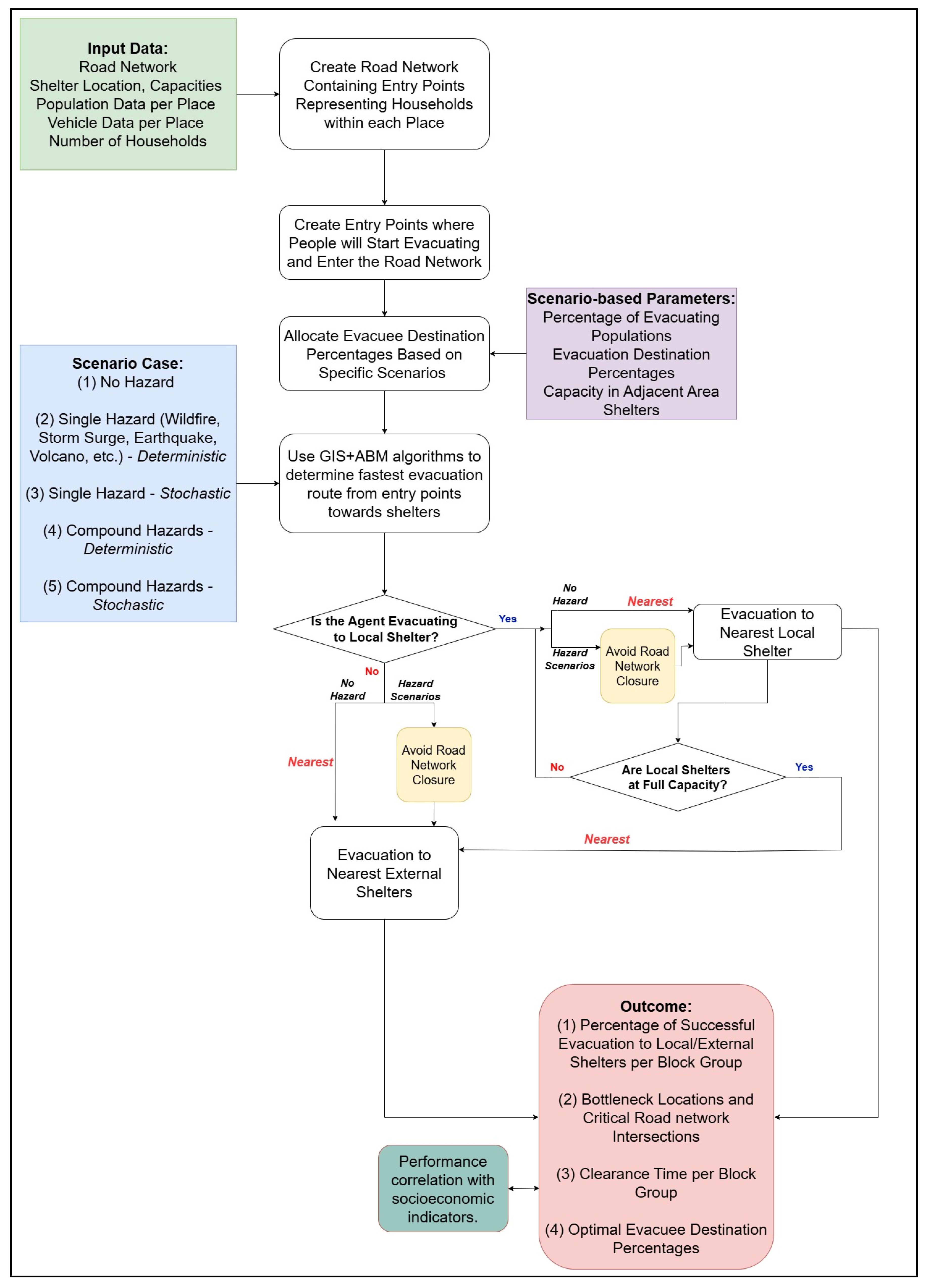
Figure 2 presents the overall conceptual flowchart of the proposed agent-based modeling (ABM) framework. Unlike hazard-specific implementations, this diagram illustrates a high-level, adaptable architecture that separates core components into modular layers: hazard modules, behavioral decision processes, dynamic network states, and performance evaluation outputs. The flowchart emphasizes how scenario-based hazard inputs (i.e., single or compound) modify network conditions and perceived risk, which in turn influence agent-level decisions regarding departure timing, destination selection, and rerouting. These individual decisions propagate through the transportation network, generating congestion dynamics and potential cascading effects that feed back into subsequent agent behavior. By structuring the framework in this layered manner, the figure demonstrates how different hazards can be interchanged without altering the behavioral core, enabling application across diverse geographic regions and risk contexts. The modular flow also clarifies the distinction between exogenous hazard processes and endogenous congestion dynamics, reinforcing the framework’s flexibility for scenario testing and decision support. The underlying equations, parameterizations, and algorithmic structures are inherently case-specific and depend on the study region, hazard type, data availability, and modeling objectives. For example, agent decision rules may be implemented using probabilistic choice models, rule-based heuristics, or machine learning predictors, while network dynamics may be represented through mesoscopic flow models, dynamic traffic assignment, or simplified capacity-speed relationships. Similarly, hazard impacts can be modeled using deterministic thresholds, probabilistic failure functions, or time-dependent degradation processes. As such, the framework is designed to provide flexible architecture. In practical applications, these components would be explicitly defined, calibrated, and validated based on local data, hazard characteristics, and planning needs. This design choice prioritizes adaptability and transferability across diverse contexts, while allowing the level of mathematical and algorithmic detail to be tailored to the specific implementation. For instance, Bustami et al. [137] implements this framework in a coastal New England case study (Westbrook, Connecticut) demonstrating its practical application under a compound hurricane scenario combining wind and storm surge. In that implementation, hazard modules were configured using storm surge inundation extents and probabilistic wind-driven road obstructions, which dynamically modified link availability and capacity over time. Behavioral parameters, including evacuation participation rates and destination preferences, were derived from the New England Hurricane Evacuation Study (NEHES) datasets [138], while agents were initialized at building-informed entry points connected to the local road network. The network layer evolved dynamically as hazard conditions and congestion interacted, and model outputs included neighborhood-scale metrics such as clearance time, shelter demand imbalance, and isolation probability. These results were used to evaluate evacuation performance and identify critical bottlenecks and underserved areas, illustrating how the proposed architecture can be operationalized to support municipal decision-making under compound hazard conditions.
Although the framework is presented conceptually, it is compatible with a wide range of existing ABM platforms. General-purpose environments such as NetLogo, Repast, and GAMA have been widely used to construct evacuation simulations with heterogeneous agents and spatially explicit networks [84,139,140,141,142]. More scalable or hybrid modeling environments, including AnyLogic and Unity-based simulation ecosystems, support integration with dynamic traffic assignment, 3D visualization, and complex decision logic [55,143]. Specialized evacuation platforms such as ESCAPE, CrowdEgress, and PRISM further enable detailed social-force modeling and immersive or virtual reality-enhanced experimentation [144,145,146]. Table 2 summarizes commonly used platforms and their relative strengths and limitations for evacuation and infrastructure modeling [147,148,149,150,151,152,153]. The layered architecture outlined in Figure 2 is intentionally software-agnostic, allowing implementation within any platform capable of representing agent-level decision rules, network dynamics, and scenario-driven hazard inputs. This ensures that the methodological contribution lies in structural organization rather than dependence on a particular computational tool.

5.3. Formalization of Model Components and Metrics

To enhance reproducibility while maintaining the flexibility of the proposed framework, this subsection provides an illustrative mathematical formulation of key model components, including state variables, behavioral parameters, and performance metrics. These formulations are not intended to constrain implementation, but rather to demonstrate how the framework can be operationalized.

5.3.1. State Variables and Time Structure

This formulation represents the evacuation process as a discrete-time system in which both agents and network conditions evolve at fixed intervals. This is shown in the equation:
t = 0 , Δ t , 2 Δ t , , T
where t is simulation time, Δ t is the time step size, and T is total simulation duration.
Each agent is characterized by a set of state variables such as location, velocity, destination, and evacuation status that collectively describe their position and progress within the system. This is shown in the equation below:
S i t = x i t , v i t , d i , E i t
where S i t is the state vector of agent i at time t , x i ( t ) is the spatial location of agent i , v i ( t ) is the velocity of agent i , d i is the destination of agent i , and E i ( t ) is the evacuation status (1 = evacuated, 0 = not evacuated).
The transportation network is represented as a graph with time-dependent link capacities, allowing infrastructure performance to vary in response to disruptions such as flooding or congestion. The following equation shows an example of how it can be represented:
C l t = C l 0 1 ϕ l t
where C l ( t ) is capacity of link l at time t , C l 0 is baseline (undisrupted) capacity, and ϕ l ( t ) is disruption factor (e.g., flooding, blockage), 0 ϕ l ( t ) 1 .
This formulation enables the representation of infrastructure as a dynamic system rather than a static background condition.

5.3.2. Behavioral Parameterization

The total number of evacuees from zone z can be estimated as:
N z evac = P z evac P o p z
where N z evac is the number of evacuees originating from zone z , P z evac is the evacuation participation rate for zone z , and P o p z is the total population in zone z . In practical applications, P z evac can be estimated from survey data such as stated household evacuation intentions or reported evacuation behavior under similar hazard conditions.
Because the number of evacuees who can leave by private vehicle is constrained by vehicle availability, the number of evacuating vehicles may be represented as:
N z veh = min V e h z     N z evac λ z
where N z veh is the number of vehicles used for evacuation from zone z , V e h z is the number of available vehicles, and λ z is the average number of evacuees per evacuating vehicle in zone z . This formulation ensures that vehicle-based evacuation demand does not exceed the available transportation resources.
A generalized form for p i can be written as:
p i = f p z survey     H z     V e h z P o p z     X i
where p z survey is the survey-based baseline participation rate in the agent’s zone, H z is hazard intensity, V e h z / P o p z is vehicle availability per capita, and X i represents additional household or behavioral attributes such as age, household size, or prior evacuation experience. This structure allows the model to remain empirically grounded while incorporating local hazard and mobility conditions.

5.3.3. Network Dynamics and Update Logic

The model evolves through a sequential update process in which infrastructure conditions and agent decisions are dynamically coupled. Link capacity is updated as:
C l t C l t + Δ t
where C l ( t + Δ t ) is the updated capacity of link l at the next time step.
Agents select routes based on current network conditions:
Route i t = arg min ( T T + γ Congestion ) paths
where Route i ( t ) is the selected path for agent i , T T is travel time along a path, γ is a weighting parameter reflecting sensitivity to congestion, and Congestion represents a congestion-related delay.
Agent positions are updated according to:
x i t + Δ t = x i t + v i t Δ t
where x i ( t + Δ t ) is the updated position of agent i , and v i ( t ) is the velocity at time t . This formulation captures the dynamic interaction between movement and network conditions over time.

5.3.4. Performance Metrics

System performance is evaluated using a set of metrics that quantify evacuation efficiency, resource demand, and risk exposure. Clearance time measures the duration required to evacuate the population, while shelter demand captures the distribution of evacuees across available facilities as follows:
T c = min t : i E i t = N evacuated
where T c is the total time required to evacuate the population, and N evacuated is the total number of agents that must evacuate.
Shelter demand is calculated as:
D s =   i 1 ( d i = s )
where D s is the demand at shelter s , and 1 ( d i = s ) is an indicator function equal to 1 if agent i selects shelter s , and 0 otherwise.
Network efficiency is defined as:
η t = i v i t i v i free
where η ( t ) represents network efficiency at time t , v i ( t ) is the actual speed of agent i , and v i free is the corresponding free-flow speed.
Exposure risk is expressed as:
R = i 0 T H ( x i ( t ) , t ) d t
where R is the cumulative exposure risk, and H ( x i ( t ) , t ) represents hazard intensity (e.g., flood depth) experienced by agent i at time t . These metrics collectively capture efficiency, demand, and safety outcomes.
These formulations illustrate how the conceptual framework can be translated into a reproducible modeling structure. Specific implementations may vary depending on the case study, available data, and modeling platform (e.g., AnyLogic, MATSim), but the underlying components like agent states, dynamic network conditions, behavioral rules, and performance metrics remain consistent.

5.4. Validation and Robustness

Validation of evacuation modeling frameworks is inherently challenging, particularly under compound hazard conditions where high-resolution empirical data on evacuation behavior, traffic dynamics, and infrastructure disruption are limited [154,155,156]. To address this, the proposed modular framework adopts a multi-layered validation and robustness strategy that evaluates both internal consistency and external plausibility while maintaining applicability in data-scarce planning contexts. Internal validation focuses on verifying the logical behavior and consistency of individual modules and their interactions. This includes component-level testing, where behavioral, routing, or hazard modules are independently modified or temporarily deactivated to evaluate their influence on system outputs. In addition, extreme-value testing is applied by setting key parameters like evacuation participation rates, shelter capacities, and network availability to upper and lower bounds to ensure stable and realistic model responses under controlled conditions. Repeated simulation runs using different random seeds are also employed to assess stochastic variability and confirm the robustness of model outputs across realizations.
External validation is conducted through comparison with available empirical and historical benchmarks. These include consistency checks against reported evacuation clearance times, congestion patterns, and shelter utilization observed in past hurricane events as well as alignment with survey-based behavioral tendencies. Where direct validation data are unavailable, synthetic scenario reconstruction and stress-testing approaches are used to evaluate whether the framework produces realistic system responses under plausible hazard conditions. To support systematic evaluation, a set of core verification indicators is defined to assess both accuracy and adaptability. These include: (i) evacuation time deviation, measured as the difference between simulated and reference clearance times where available; (ii) prediction consistency of key outcomes such as evacuation failure or isolation probability across scenarios; (iii) spatial accuracy of congestion and shelter demand patterns; and (iv) stability of results under repeated stochastic simulations. For the modular structure, additional indicators evaluate consistency after module substitution or modification, ensuring that the framework maintains coherent system behavior when individual components are updated or replaced.
Robustness under data-scarce conditions is addressed through simplified parameterization and controlled uncertainty bounds. Where detailed local data are unavailable, the framework supports the use of representative survey datasets, regional averages, or literature-based parameter ranges to approximate behavioral and infrastructural inputs. Sensitivity to these assumptions is managed through scenario variation and bounded parameter testing, which help identify the range of possible outcomes and reduce overconfidence in single deterministic results. This approach enables practical implementation in real-world planning environments where data limitations are common, while maintaining transparency in model assumptions and uncertainty.

6. Discussion & Policy Relevance

Evacuation modeling has matured considerably over the past two decades, yet the translation of modeling advances into operational municipal planning remains uneven. Sophisticated agent-based simulations now incorporate behavioral heterogeneity, probabilistic decision rules, congestion feedback, and dynamic routing. However, many implementations remain hazard-specific, data-intensive, or optimized for academic validation rather than for iterative use by local planners. Thus, the gap is not primarily technical; it is structural. Academic models often prioritize validation, algorithmic sophistication, or hazard-specific realism, while municipal agencies require adaptable, scenario-driven tools that can be updated, interpreted, and deployed under evolving risk conditions. Policy implications and relevance are built around two components: (1) methodological implications for compound-hazard modeling and multi-layer system integration, and (2) practical implications for municipal planning, shelter management, and infrastructure prioritization.

6.1. Compound-Hazard Preparedness in Municipal Planning

For local governments, evacuation planning is not an abstract modeling problem; it is an operational responsibility that must function under uncertainty, resource constraints, and changing hazard profiles. Effective evacuation performance emerges from the interaction of three interdependent systems: individual decision-making, transportation network dynamics, and evolving hazard processes. In practice, these components are often developed and applied in isolation rather than as an integrated system. Planning tools may capture behavioral responses without fully accounting for how network conditions evolve, or represent hazard impacts without reflecting how congestion and accessibility change in real time. This disconnect can lead to evacuation strategies that rely on simplified assumptions about disruption, treating it as stable or compartmentalized rather than dynamic and interacting.
Operational planning requires a different approach. Instead of embedding hazard impacts within case-specific assumptions, municipal models must be structured to accommodate uncertainty across multiple interacting drivers. A modular hazard architecture provides this flexibility. In practical terms, this means representing hazard effects not as fixed closures derived from a single flood raster or wildfire perimeter, but as probabilistic and time-varying degradation processes that influence link capacity, accessibility, and travel speed. Wind damage, storm surge, wildfire spread, seismic debris, or landslide obstructions can then be introduced as interchangeable modules without altering the behavioral decision core of the model. Guo et al. [136] emphasize the value of separating agents, environment, and event processes to enhance reusability; within evacuation planning, this separation enables towns in different hazard contexts to apply a common structural framework while customizing local hazard inputs.
This modularization has direct policy implications. Many municipal evacuation models are developed in response to specific events or regulatory needs, which can anchor them to particular hazard conditions. While this improves realism for individual scenarios, it also reduces their flexibility when conditions change. As hazard profiles evolve, models often require substantial reconfiguration rather than incremental adaptation, limiting their usefulness for ongoing planning and scenario exploration. An adaptable compound-hazard structure reduces this institutional friction by allowing scenario substitution rather than model redesign.
Equally important is carefully constructing a robust and interactive network system. Many evacuation models assume stable network conditions or apply disruptions in a static manner, which can overlook how system performance changes during the event itself. In reality, infrastructure is sensitive to both hazard impacts and evacuation demand, where congestion, failures, and capacity reductions can emerge and propagate over time, reshaping accessibility as the evacuation unfolds. Barrett et al. [18] show that compliance levels can trigger nonlinear congestion and communication overloads. Mühlhofer et al. [34] further demonstrate that cascading disruptions often account for most service impacts during compound events. From a municipal planning perspective, this means that evacuation-induced loading and hazard-induced degradation must be modeled as co-evolving processes rather than sequential inputs.
A dynamic network-state representation therefore becomes central to operational planning. Instead of binary open-or-closed road segments, links may experience probabilistic failure, partial capacity reduction, delayed clearance, or staged recovery. Congestion feedback influences travel time, which then reshapes departure decisions and route selection. Spillback effects can propagate disruptions beyond initially affected corridors, amplifying localized impacts. Smyrnakis and Galla [26] and Firdausyi et al. [27] demonstrate how individually rational routing decisions can degrade overall system performance, reinforcing the importance of endogenous feedback modeling. For planners, this translates into a clearer understanding of where congestion hotspots may emerge under compound conditions and how network fragility varies across neighborhoods.
Compound hazards further emphasize the need for scenario-based evaluation. Multi-hazard resilience research indicates that hazard interactions are rarely additive. Argyroudis et al. [1] show that sequential or simultaneous hazard exposures can produce markedly different system performance trajectories compared to isolated events. In evacuation contexts, different combinations and sequences of hazards can alter both infrastructure performance and behavioral responses in non-linear ways. As a result, planning benefits from examining a range of plausible scenarios rather than relying on a single outcome. Scenario-based simulation enables municipalities to assess robustness, identify thresholds of system instability, and compare intervention strategies under varied compound-risk conditions.
Importantly, the framework does not prescribe hazard-specific parameters. Its value lies in defining structural requirements that support adaptability: probabilistic link degradation, time-varying capacity, endogenous congestion feedback, and configurable scenarios. This structure allows coastal towns, wildfire-prone communities, seismic regions, or multi-risk metropolitan areas to implement the same methodological backbone while tailoring hazard modules to local conditions. The result is not a model tied to one geography, but an institutional planning tool that can evolve alongside changing hazard landscapes.
Embedding neighborhood-scale performance metrics into planning practice addresses a persistent blind spot in evacuation assessment. Aggregate clearance time remains a dominant indicator across many studies [47,64]. While useful for benchmarking overall performance, system-wide averages can obscure spatial inequities. Certain communities may experience prolonged isolation, limited shelter accessibility, or disproportionate congestion even when total clearance appears acceptable. For municipal decision-makers, these localized disparities are often more relevant than aggregate efficiency. Incorporating origin-based metrics such as block-group clearance time, isolation probability, normalized evacuation duration, and unmet shelter demand enables targeted mitigation strategies rather than uniform system-wide prescriptions.
Operationalizing compound risk, therefore, requires more than improved simulation fidelity. It demands structural reconfiguration of evacuation modeling to support adaptability, scenario comparison, dynamic infrastructure interaction, and spatially resolved outputs. The methodological implications of this planning-oriented shift are summarized in Table 3.

6.2. Decision Support for Shelter, Infrastructure, and Evacuation Timing

Even the most sophisticated evacuation model has limited value if it cannot inform real decisions under real constraints. Municipal emergency managers operate within budget cycles, staffing limits, political oversight, and public scrutiny. Tools that require extensive recalibration, advanced programming expertise, or opaque optimization routines are unlikely to be integrated into routine planning practice. What local governments need are systems that translate simulation outputs into interpretable, scenario-sensitive insights that directly support timing, shelter, and infrastructure decisions. To synthesize these planning implications, Table 4 organizes the framework’s operational contributions across key municipal decision domains, including evacuation timing, shelter allocation, infrastructure prioritization, and communication strategy. Rather than presenting abstract methodological features, the table translates simulation capabilities into concrete planning actions, associated metrics, and potential implementation pathways.
Scenario-based simulation plays a central role in this translation. Instead of producing a single evacuation time estimate tied to one assumed hazard condition, planners can examine performance variability across alternative compound configurations. A coastal municipality may compare wind-only impacts, surge-only inundation, and combined wind-surge degradation to determine how road fragility shifts under each configuration. A wildfire-exposed jurisdiction might test smoke-induced speed reduction together with phased evacuation compliance levels to identify when visibility constraints begin to destabilize network flow. In seismic regions, debris-related link failures can be layered with congestion surges to evaluate secondary isolation risk. The objective is not prediction of a single outcome, but stress-testing of the system across plausible hazard combinations. This approach shifts evacuation planning from reactive estimation toward anticipatory resilience design. Rather than asking how long evacuation would take under one assumed scenario, planners can ask which hazard combinations generate persistent bottlenecks, which compliance ranges trigger network overload, and which neighborhoods repeatedly experience delayed clearance. Such insight directly informs evacuation order timing, staged departure policies, and pre-event infrastructure reinforcement.
Shelter system evaluation similarly benefits from origin-resolved analytics. Traditional shelter planning often emphasizes total capacity or optimized allocation, yet system-wide adequacy does not guarantee spatial equity. Du et al. [73] demonstrate that adding shelters without strategic siting does not necessarily improve performance. Milburn et al. [76] further show that evacuees do not consistently select the nearest shelter, undermining simplified proximity assumptions. When shelter demand is traced back to specific origins, planners can detect which neighborhoods generate overflow under varied scenarios, whether imbalances stem from capacity constraints or routing congestion, and how alternative shelter activation strategies redistribute flows. This transforms shelter planning from aggregate capacity accounting into spatial demand management.
Departure timing represents another actionable layer. Empirical research highlights the importance of information dissemination and behavioral responsiveness in shaping congestion dynamics. Siam et al. [92] show that warning delays materially alter evacuation curves, while studies such as Roy et al. [17] and Sun et al. [3] illustrate how compliance and risk perception influence participation rates. Incorporating behavioral sensitivity testing into scenario runs enables planners to evaluate how earlier orders, staggered departure windows, or targeted communication campaigns affect peak loading. Rather than assuming fixed participation rates, municipalities can identify threshold conditions where marginal increases in compliance begin to overwhelm infrastructure capacity. This supports more nuanced communication strategies that balance urgency with network stability.
Infrastructure prioritization also becomes more defensible when informed by repeated scenario performance. Road segments or intersections that consistently exhibit high congestion, extended spillback, or elevated isolation probability across multiple hazard combinations represent structural weaknesses. These recurrent bottlenecks provide empirical justification for targeted capital improvements such as signal backup systems, lane widening, contraflow planning, debris clearance prioritization, or culvert reinforcement. Aligning such findings with hazard mitigation funding mechanisms strengthens grant applications by grounding proposals in simulation-based evidence rather than anecdotal observation.
Beyond technical optimization, transparency remains critical. Municipal decision environments require metrics that can be communicated clearly to elected officials, grant reviewers, and community stakeholders. Aggregate optimization outputs or abstract efficiency scores rarely translate into actionable policy language. In contrast, neighborhood-level indicators such as clearance time distribution, evacuee percentage-normalized evacuation duration, isolation probability, and shelter deficit mapping align more directly with planning discourse. These metrics allow stakeholders to visualize disparities, compare alternatives, and justify interventions without requiring familiarity with simulation algorithms.
Importantly, the framework also allows planners to examine equity implications without embedding deterministic demographic assumptions directly into agent behavior. Instead of prescribing behavior based on socioeconomic proxies, post-simulation analysis can evaluate performance disparities across neighborhoods. If certain areas consistently exhibit longer clearance times, higher isolation probability, or elevated shelter overflow under comparable hazard exposure, planners can investigate structural causes such as limited egress routes, constrained vehicle access, or communication gaps. This approach aligns with vulnerability-informed planning perspectives while avoiding reductionist behavioral modeling.
Ultimately, the policy relevance of this framework lies in its ability to integrate multiple planning dimensions within a single, adaptable architecture. It supports evacuation order evaluation, shelter strategy refinement, communication timing analysis, and infrastructure prioritization without requiring hazard-specific reconstruction. By linking modular hazard representation with dynamic network interaction and spatially resolved outputs, the framework transforms evacuation modeling from an academic exercise into a practical decision-support instrument. The result is not simply improved simulation fidelity, but improved institutional capacity to plan under uncertainty, justify investments, and communicate risk transparently across communities.

7. Conclusions

Evacuation modeling is entering a phase in which the central challenge is no longer behavioral realism or traffic representation in isolation, but the integration of interacting hazards, adaptive agents, and evolving infrastructure within coherent and reusable system architectures. While substantial methodological progress has been achieved across behavioral, traffic, and hazard modeling domains, these advances often remain compartmentalized within hazard-specific or region-specific implementations. The contribution of this review lies in articulating an adaptable compound-hazard framework that organizes these advances into a modular and adaptable structure, positioning evacuation simulation as a configurable planning instrument rather than a single-case analytical exercise.
The proposed architecture provides a foundation for comparative, scenario-driven analysis under uncertainty. By supporting interchangeable hazard modules, dynamic network evolution, and spatially resolved performance outputs, the framework enables systematic exploration of how compound drivers alter evacuation outcomes across varying intensities, compliance conditions, and infrastructure stress states. This shift from deterministic clearance estimation toward variability-based performance assessment aligns evacuation modeling with contemporary resilience thinking and risk-informed planning.
Several limitations should be acknowledged when interpreting the proposed framework and its application for evacuation planning. First, while the modular architecture enhances flexibility and adaptability, it may introduce additional computational overhead, particularly when scaling the framework to larger geographic regions with high-resolution transportation networks and large agent populations. Running multiple compound hazard scenarios with dynamic network updates and stochastic processes can increase computational cost and runtime, which may limit real-time applicability for some municipal agencies with constrained computational resources. Although the modular design facilitates incremental model development and targeted updates, efficient implementation and parallelization strategies may be required for large-scale applications. Second, the evaluation of equity outcomes is based on area-level socioeconomic indicators (e.g., income, renter share, age distribution, disability prevalence, and vehicle access) applied at the neighborhood or block-group scale. While this approach avoids embedding deterministic demographic assumptions directly into agent behavior, it introduces limitations associated with aggregate proxies. In particular, results may be sensitive to how spatial units are defined, and the use of area-based indicators may mask within-neighborhood heterogeneity or lead to ecological fallacy when interpreting outcomes at the individual level. Additionally, equity assessments depend on the selection and weighting of vulnerability indicators, which may influence conclusions regarding disparities in evacuation performance. Third, data availability remains a key constraint. In many real-world planning contexts, detailed behavioral, infrastructure, and hazard datasets are limited or unavailable, requiring the use of proxy data, regional averages, or literature-based assumptions. While the framework is designed to operate under such conditions, these approximations introduce uncertainty into model outputs and should be considered when interpreting results.
Future work should focus on operationalizing this architecture across diverse geographic contexts and hazard portfolios to test its transferability in practice. Applied case studies can evaluate how the modular structure performs under coastal wind–surge systems, wildfire–smoke interactions, seismic–landslide coupling, or other region-specific compound risks. Empirical calibration of behavioral processes, probabilistic infrastructure degradation functions, and recovery dynamics remains a priority for strengthening predictive validity. In parallel, deeper integration of cascading infrastructure interdependencies and communication system effects will enhance the representation of nonlinear disruption patterns.
Ultimately, advancing compound-hazard evacuation modeling requires moving beyond isolated methodological refinement toward integrative, cross-disciplinary development. By structuring behavioral, network, and hazard processes within a unified yet adaptable framework, evacuation simulation can better support comparative planning, institutional learning, and equitable resilience strategies under increasingly complex risk environments.

Author Contributions

Conceptualization, O.B. and F.R.; Methodology, O.B. and F.R.; Formal analysis, O.B. and F.R.; Investigation, O.B. and F.R.; Resources, F.R. and A.B.; Data curation, O.B. and F.R.; Writing—original draft, O.B. and F.R.; Writing—review & editing, O.B., F.R. and A.B.; Visualization, O.B. and F.R.; Supervision, F.R. and A.B. All authors have read and agreed to the published version of the manuscript.

Funding

This study received no external funding.

Institutional Review Board Statement

Not applicable.

Informed Consent Statement

Not applicable.

Data Availability Statement

The original contributions presented in this study are included in the article. Further inquiries can be directed to the corresponding authors.

Conflicts of Interest

The authors declare no conflicts of interest.

References

  1. Argyroudis, S.A.; Mitoulis, S.A.; Hofer, L.; Zanini, M.A.; Tubaldi, E.; Frangopol, D.M. Resilience Assessment Framework for Critical Infrastructure in a Multi-Hazard Environment: Case Study on Transport Assets. Sci. Total Environ. 2020, 714, 136854. [Google Scholar] [CrossRef]
  2. Markogiannaki, O.; Karatzeztou, A.; Stefanidou, S.; Tsinidis, G. RESILIENCE ASSESSMENT OF ROAD BRIDGES IN MULTI-HAZARD ENVIRONMENT. In Proceedings of the COMPDYN 2023 9th ECCOMAS Thematic Conference on Computational Methods in Structural Dynamics and Earthquake Engineering, Athens, Greece, 12–14 June 2023. [Google Scholar] [CrossRef]
  3. Sun, Y.; Forrister, A.; Kuligowski, E.D.; Lovreglio, R.; Cova, T.J.; Zhao, X. Social Vulnerabilities and Wildfire Evacuations: A Case Study of the 2019 Kincade Fire. Saf. Sci. 2024, 176, 106557. [Google Scholar] [CrossRef]
  4. Ansari, A.; El-Hussain, I.; Al Shijbi, Y.; Mandhaniya, P.; Alluqmani, A.E.; Al-Jabri, K. Robustness Assessment of Muscat Coastal Highway Network (CHN) under Multi-Hazard Scenarios Focusing on Traffic Stability and Adaptation Measures. Sci. Rep. 2024, 14, 30632. [Google Scholar] [CrossRef]
  5. Nofal, O.M.; Amini, K.; Padgett, J.E.; van de Lindt, J.W.; Rosenheim, N.; Darestani, Y.M.; Enderami, A.; Sutley, E.J.; Hamideh, S.; Duenas-Osorio, L. Multi-Hazard Socio-Physical Resilience Assessment of Hurricane-Induced Hazards on Coastal Communities. Resilient Cities Struct. 2023, 2, 67–81. [Google Scholar] [CrossRef]
  6. Rohaert, A.; Kuligowski, E.D.; Ardinge, A.; Wahlqvist, J.; Gwynne, S.M.V.; Kimball, A.; Bénichou, N.; Ronchi, E. Traffic Dynamics during the 2019 Kincade Wildfire Evacuation. Transp. Res. D Transp. Environ. 2023, 116, 103610. [Google Scholar] [CrossRef]
  7. Pishahang, M.; Ruiz-Tagle, A.; Ramos, M.A.; Droguett, E.L.; Mosleh, A. A Bayesian Agent-Based Model and Software for Wildfire Safe Evacuation Planning and Management. Proc. Inst. Mech. Eng. O J. Risk Reliab. 2025, 239, 515–534. [Google Scholar] [CrossRef]
  8. Rahimi-Golkhandan, A.; Aslani, B.; Mohebbi, S. Predictive Resilience of Interdependent Water and Transportation Infrastructures: A Sociotechnical Approach. Socioecon. Plann. Sci. 2022, 80, 101166. [Google Scholar] [CrossRef]
  9. Twumasi-Boakye, R.; Sobanjo, J. Civil Infrastructure Resilience: State-of-the-Art on Transportation Network Systems. Transp. A Transp. Sci. 2019, 15, 455–484. [Google Scholar] [CrossRef]
  10. Farahani, S.; Shojaeian, A.; Behnam, B.; Roohi, M. Probabilistic Seismic Multi-Hazard Risk and Restoration Modeling for Resilience-Informed Decision Making in Railway Networks. Sustain. Resilient Infrastruct. 2023, 8, 470–491. [Google Scholar] [CrossRef]
  11. Cegan, J.C.; Golan, M.S.; Joyner, M.D.; Linkov, I. The Importance of Compounding Threats to Hurricane Evacuation Modeling. npj Urban Sustain. 2022, 2, 2. [Google Scholar] [CrossRef]
  12. Shan, S.; Guo, X.; Wei, Z.; Sun, W.; Zheng, H.; Pan, H.; Lin, J. Simulation Analysis of Evacuation Processes in a Subway Station Based on Multi-Disaster Coupling Scenarios. Int. J. Disaster Risk Reduct. 2023, 96, 103998. [Google Scholar] [CrossRef]
  13. Kim, J.; Takabatake, T.; Nistor, I.; Shibayama, T. A Comparison between Agent-Based and GIS-Based Tsunami Evacuation Simulations: A Case Study for Tofino, BC. Can. J. Civ. Eng. 2022, 49, 511–526. [Google Scholar] [CrossRef]
  14. Zhao, B.; Wong, S.D. Developing Transportation Response Strategies for Wildfire Evacuations via an Empirically Supported Traffic Simulation of Berkeley, California. Transp. Res. Rec. 2021, 2675, 557–582. [Google Scholar] [CrossRef]
  15. Adjei, E.; Murray-Tuite, P.; Ge, Y.; Ukkusuri, S.; Lee, S. Estimating Hurricane Evacuation Destination and Accommodation Type Selection with Perceived Certainty Variables. Transp. Res. D Transp. Environ. 2022, 105, 103235. [Google Scholar] [CrossRef]
  16. Opdyke, A.; Bodo, D.D.; Smyth, J. Higher Ground or into Harm’s Way? Household Storm Surge Sheltering and Evacuation Plans. Int. J. Disaster Risk Reduct. 2024, 106, 104452. [Google Scholar] [CrossRef]
  17. Roy, K.C.; Hasan, S.; Abdul-Aziz, O.I.; Mozumder, P. Understanding the Influence of Multiple Information Sources on Risk Perception Dynamics and Evacuation Decisions: An Agent-Based Modeling Approach. Int. J. Disaster Risk Reduct. 2022, 82, 103328. [Google Scholar] [CrossRef]
  18. Barrett, C.; Channakeshava, K.; Huang, F.; Kim, J.; Marathe, A.; Marathe, M.V.; Pei, G.; Saha, S.; Subbiah, B.S.P.; Vullikanti, A.K.S. Human Initiated Cascading Failures in Societal Infrastructures. PLoS ONE 2012, 7, e45406. [Google Scholar] [CrossRef]
  19. Rouhana, F.; Jawad, D. Transportation Network Resilience against Failures: GIS-Based Assessment of Network Topology Role. Int. J. Disaster Resil. Built Environ. 2021, 12, 357–370. [Google Scholar] [CrossRef]
  20. Zhu, Y.; Ozbay, K.; Yang, H.; Zuo, F.; Sha, D. Modeling and Simulation of Cascading Failures in Transportation Systems during Hurricane Evacuations. J. Adv. Transp. 2021, 2021, 5599073. [Google Scholar] [CrossRef]
  21. Ghorbanzadeh, M.; Vijayan, L.; Yang, J.; Ozguven, E.E.; Huang, W.; Ma, M. Integrating Evacuation and Storm Surge Modeling Considering Potential Hurricane Tracks: The Case of Hurricane Irma in Southeast Florida. ISPRS Int. J. Geo-Inf. 2021, 10, 661. [Google Scholar] [CrossRef]
  22. Harris, A.; Morss, R.; Davis, C.; Roebber, P.; Boehnert, J. FLEE 2.0: An Improved Agent-Based Model of Hurricane Evacuations. Weather Clim. Soc. 2025, 17, 729–744. [Google Scholar] [CrossRef]
  23. Grajdura, S.; Borjigin, S.; Niemeier, D. Fast-Moving Dire Wildfire Evacuation Simulation. Transp. Res. D Transp. Environ. 2022, 104, 103190. [Google Scholar] [CrossRef]
  24. Zhang, B.; Chan, W.K.; Ukkusuri, S.V. Agent-Based Modeling for Household Level Hurricane Evacuation. In Proceedings of the 2009 Winter Simulation Conference (WSC), Austin, TX, USA, 13–16 December 2009; pp. 2278–2284. [Google Scholar] [CrossRef]
  25. Senanayake, G.P.D.P.; Kieu, M.; Zou, Y.; Dirks, K. Agent-Based Simulation for Pedestrian Evacuation: A Systematic Literature Review. Int. J. Disaster Risk Reduct. 2024, 111, 104705. [Google Scholar] [CrossRef]
  26. Smyrnakis, M.; Galla, T. Effects of Communication and Utility-Based Decision Making in a Simple Model of Evacuation. Eur. Phys. J. B 2012, 85, 378. [Google Scholar] [CrossRef]
  27. Firdausyi, A.M.; Dini, S.U.; Nurafni, S.; Viridi, S. Pedestrian Evacuation Modeling Using Agent-Based Model and Social-Force Model. J. Phys. Conf. Ser. 2024, 2734, 012032. [Google Scholar] [CrossRef]
  28. Yin, D.; Wang, S.; Ouyang, Y. ViCTS: A Novel Network Partition Algorithm for Scalable Agent-Based Modeling of Mass Evacuation. Comput. Environ. Urban Syst. 2020, 80, 101452. [Google Scholar] [CrossRef]
  29. Idoudi, H.; Ameli, M.; Van Phu, C.N.; Zargayouna, M.; Rachedi, A. An Agent-Based Dynamic Framework for Population Evacuation Management. IEEE Access 2022, 10, 88606–88620. [Google Scholar] [CrossRef]
  30. Zhang, T.; Ren, G.; Cheng, G.; Yang, Y.; Jin, M. A Stochastic Dynamic Traffic Assignment Model for Emergency Evacuations That Considers Background Traffic. IEEE Intell. Transp. Syst. Mag. 2022, 14, 206–220. [Google Scholar] [CrossRef]
  31. Rouhana, F.; Jawad, D. A Spatial-Network Approach to Assessing Transportation Resilience in Disaster-Prone Urban Areas. ISPRS Int. J. Geo-Inf. 2025, 14, 261. [Google Scholar] [CrossRef]
  32. Sakamoto, M.; Sasaki, D.; Ono, Y.; Makino, Y.; Kodama, E.N. Implementation of Evacuation Measures during Natural Disasters under Conditions of the Novel Coronavirus (COVID-19) Pandemic Based on a Review of Previous Responses to Complex Disasters in Japan. Prog. Disaster Sci. 2020, 8, 100127. [Google Scholar] [CrossRef]
  33. Tripathy, S.S.; Bhatia, U.; Mohanty, M.; Karmakar, S.; Ghosh, S. Flood Evacuation during Pandemic: A Multi-Objective Framework to Handle Compound Hazard. Environ. Res. Lett. 2021, 16, 034034. [Google Scholar] [CrossRef]
  34. Mühlhofer, E.; Bresch, D.N.; Koks, E.E. Infrastructure Failure Cascades Quintuple Risk of Storm and Flood-Induced Service Disruptions across the Globe. One Earth 2024, 7, 714–729. [Google Scholar] [CrossRef]
  35. Yin, K.; Wu, J.; Wang, W.; Lee, D.H.; Wei, Y. An Integrated Resilience Assessment Model of Urban Transportation Network: A Case Study of 40 Cities in China. Transp. Res. Part A Policy Pract. 2023, 173, 103687. [Google Scholar] [CrossRef]
  36. Zhu, W.; Wang, S.; Liu, S.; Gao, X.; Zhang, P.; Zhang, L. Reliability and Robustness Assessment of Highway Networks under Multi-Hazard Scenarios: A Case Study in Xinjiang, China. Sustainability 2023, 15, 5379. [Google Scholar] [CrossRef]
  37. Alçada-Almeida, L.; Tralhão, L.; Santos, L.; Coutinho-Rodrigues, J. A Multiobjective Approach to Locate Emergency Shelters and Identify Evacuation Routes in Urban Areas. Geogr. Anal. 2009, 41, 9–29. [Google Scholar] [CrossRef]
  38. Di Gangi, M.; Belcore, O.M. RISK REDUCTION IN TRANSPORT SYSTEM IN EMERGENCY CONDITIONS: A FRAMEWORK FOR DECISION SUPPORT SYSTEMS. WIT Trans. Built Environ. 2021, 206, 299–311. [Google Scholar]
  39. Russo, F.; Rindone, C. Safety of Users in Road Evacuation: Modelling and DSS for LFA in the Planning Process. WIT Trans. Ecol. Environ. 2009, 120, 453–464. [Google Scholar]
  40. Harris, A.; Morss, R.; Roebber, P. What Improves Evacuations: Exploring the Hurricane-Forecast-Evacuation System Dynamics Using an Agent-Based Framework. Nat. Hazards Rev. 2023, 24. [Google Scholar] [CrossRef]
  41. Trivedi, A.; Rao, S. Agent-Based Modeling of Emergency Evacuations Considering Human Panic Behavior. IEEE Trans. Comput. Soc. Syst. 2018, 5, 277–288. [Google Scholar] [CrossRef]
  42. Ahmed, M.A.; Sadri, A.M.; Hadi, M. Modeling Social Network Influence on Hurricane Evacuation Decision Consistency and Sharing Capacity. Transp. Res. Interdiscip. Perspect. 2020, 7, 100180. [Google Scholar] [CrossRef]
  43. Chang, K.H.; Hsu, C.C.; Su, W.R. An Agent-Based Simulation Framework for Emergency Evacuations from Toxic Gas Incidents and an Empirical Study in Taiwan. Comput. Oper. Res. 2024, 167, 106645. [Google Scholar] [CrossRef]
  44. Grajdura, S.A.; Borjigin, S.G.; Niemeier, D.A. Agent-Based Wildfire Evacuation with Spatial Simulation: A Case Study. In Proceedings of the 3rd ACM SIGSPATIAL International Workshop on GeoSpatial Simulation, GeoSim 2020; ACM: New York, NY, USA, 2020; pp. 56–59. [Google Scholar] [CrossRef]
  45. Rice, C.L.; Coleman, R.J.; Price, M.; San, E.; Inc, J. Clarifying Evacuation Options through Fire Behavior and Traffic Modeling. In Proceedings of the Second Conference on the Human Dimensions of Wildland Fire. General Technical Report NRS-P-84; McCaffrey Sarah, M., Cherie LeBlanc, F., Eds.; Department of Agriculture, Forest Service, Northern Research Station: Newtown Square, PA, USA, 2011; Volume 84, pp. 104–111. Available online: https://research.fs.usda.gov/treesearch/38523 (accessed on 15 February 2026).
  46. Ronchi, E.; Rein, G.; Gwynne, S.M.V.; Intini, P.; Wadhwani, R. Framework for an Integrated Simulation System for Wildland-Urban Interface Fire Evacuation. Paper Presented at Fire Safety 2017, Cantabria, Spain. Available online: https://portal.research.lu.se/en/publications/1840add0-243c-40b1-a60c-e7f7e2be3b51 (accessed on 15 February 2026).
  47. Kim, M.; Cho, G.H. Influence of Evacuation Policy on Clearance Time under Large-Scale Chemical Accident: An Agent-Based Modeling. Int. J. Environ. Res. Public Health 2020, 17, 9442. [Google Scholar] [CrossRef] [PubMed]
  48. Takabatake, T.; Fujisawa, K.; Esteban, M.; Shibayama, T. Simulated Effectiveness of a Car Evacuation from a Tsunami. Int. J. Disaster Risk Reduct. 2020, 47, 101532. [Google Scholar] [CrossRef]
  49. Zayn, A.R.; Ramdani, F.; Bachtiar, F.A. Agent-Based Modeling and Simulation for Evacuation of Landslides Natural Disaster. J. Inf. Technol. Comput. Sci. 2020, 5, 194–206. [Google Scholar] [CrossRef]
  50. Beyki, S.M.; Santiago, A.; Laím, L.; Craveiro, H.D. Evacuation Simulation under Threat of Wildfire—An Overview of Research, Development, and Knowledge Gaps. Appl. Sci. 2023, 13, 9587. [Google Scholar] [CrossRef]
  51. Flores, C.; Lee, H.S.; Mas, E. Understanding Tsunami Evacuation via a Social Force Model While Considering Stress Levels Using Agent-Based Modelling. Sustainability 2024, 16, 4307. [Google Scholar] [CrossRef]
  52. Perepelitsa, I.; Quaini, A. Coupling Microscopic and Mesoscopic Models for Crowd Dynamics with Emotional Contagion. Front. Phys. 2025, 13, 1644470. [Google Scholar] [CrossRef]
  53. Barnes, B.; Dunn, S.; Wilkinson, S. Replicating Capacity and Congestion in Microscale Agent-Based Simulations. Travel Behav. Soc. 2022, 29, 308–318. [Google Scholar] [CrossRef]
  54. Ye, J.; Liu, Z.; Liu, T.; Wu, Y.; Wang, Y. Crowd Evacuation Simulation Based on Hierarchical Agent Model and Physics-Based Character Control. Comput. Animat. Virtual Worlds 2024, 35, e2263. [Google Scholar] [CrossRef]
  55. Wang, Y.; Ge, J.; Comber, A. An Agent-Based Simulation Model of Pedestrian Evacuation Based on Bayesian Nash Equilibrium. J. Artif. Soc. Soc. Simul. 2023, 26, 2023. [Google Scholar] [CrossRef]
  56. Wu, W.; Li, J.; Yi, W.; Zheng, X. Modeling Crowd Evacuation via Behavioral Heterogeneity-Based Social Force Model. IEEE Trans. Intell. Transp. Syst. 2022, 23, 15476–15486. [Google Scholar] [CrossRef]
  57. Kuligowski, E. Evacuation Decision-Making and Behavior in Wildfires: Past Research, Current Challenges and a Future Research Agenda. Fire Saf. J. 2021, 120, 103129. [Google Scholar] [CrossRef]
  58. Alqurashi, R.; Altman, T. Multi-Level Multi-Stage Agent-Based Decision Support System for Simulation of Crowd Dynamics. In Proceedings of the IEEE International Conference on Engineering of Complex Computer Systems, ICECCS, Melbourne, Australia, 12–14 December 2018; pp. 82–92. [Google Scholar] [CrossRef]
  59. Kolen, B.; Helsloot, I. Decision-Making and Evacuation Planning for Flood Risk Management in The Netherlands. Disasters 2014, 38, 610–635. [Google Scholar] [CrossRef]
  60. Rodrigueza, R.C.; Estuar, M.R.J.E. A Spatial Agent-Based Model for Preemptive Evacuation Decisions during Typhoon. In Proceedings of the 2021 IEEE/ACM International Conference on Advances in Social Networks Analysis and Mining, ASONAM; IEEE: New York, NY, USA, 2021; pp. 39–42. [Google Scholar] [CrossRef]
  61. Sohn, W.; Kotval-Karamchandani, Z. Risk Perception of Compound Emergencies: A Household Survey on Flood Evacuation and Sheltering Behavior during the COVID-19 Pandemic. Sustain. Cities Soc. 2023, 94, 104553. [Google Scholar] [CrossRef] [PubMed]
  62. Yusuf, J.E.; Whytlaw, J.L.; Hutton, N.; Olanrewaju-Lasisi, T.; Giles, B.; Lawsure, K.; Behr, J.; Diaz, R.; McLeod, G. Evacuation Behavior of Households Facing Compound Hurricane-Pandemic Threats. Public Adm. Rev. 2023, 83, 1186–1201. [Google Scholar] [CrossRef]
  63. Harris, A.; Roebber, P.; Morss, R. An Agent-Based Modeling Framework for Examining the Dynamics of the Hurricane-Forecast-Evacuation System. Int. J. Disaster Risk Reduct. 2022, 67, 102669. [Google Scholar] [CrossRef]
  64. Liang, W.; Lam, N.S.N.; Qin, X.; Ju, W. A Two-Level Agent-Based Model for Hurricane Evacuation in New Orleans. J. Homel. Secur. Emerg. Manag. 2015, 12, 407–435. [Google Scholar] [CrossRef]
  65. Alam, M.J.; Habib, M.A. A Dynamic Programming Optimization for Traffic Microsimulation Modelling of a Mass Evacuation. Transp. Res. D Transp. Environ. 2021, 97, 102946. [Google Scholar] [CrossRef]
  66. Li, B.; Liu, C.; Mostafavi, A.; Lab, U. Evac-Cast: An Interpretable Machine-Learning Framework for Evacuation Forecasts Across Hurricanes and Wildfires. arXiv 2025, arXiv:2508.00650. [Google Scholar]
  67. Liu, T.; Meidani, H. Graph Neural Networks for Travel Distance Estimation and Route Recommendation under Probabilistic Hazards. Int. J. Transp. Sci. Technol. 2026, 21, 372–383. [Google Scholar] [CrossRef]
  68. Wang, X.; Mohcine, C.; Chen, J.; Li, R.; Ma, J. Modeling Boundedly Rational Route Choice in Crowd Evacuation Processes. Saf. Sci. 2022, 147, 105590. [Google Scholar] [CrossRef]
  69. Stephens, K.K.; Jafari, E.; Boyles, S.; Ford, J.L.; Zhu, Y. Increasing Evacuation Communication Through ICTs: An Agent-Based Model Demonstrating Evacuation Practices and the Resulting Traffic Congestion in the Rush to the Road. J. Homel. Secur. Emerg. Manag. 2015, 12, 497–528. [Google Scholar] [CrossRef]
  70. de Araujo, M.P.; Lupa, M.R.; Casper, C.T.; Waters, B. Wildfire Evacuation Scenario in Colorado. Transp. Res. Rec. J. Transp. Res. Board 2014, 2430, 133–144. [Google Scholar] [CrossRef]
  71. Zhao, L.; Li, H.; Sun, Y.; Huang, R.; Hu, Q.; Wang, J.; Gao, F. Planning Emergency Shelters for Urban Disaster Resilience: An Integrated Location-Allocation Modeling Approach. Sustainability 2017, 9, 2098. [Google Scholar] [CrossRef]
  72. Qiu, J.; Tan, H.; Yuan, S.; Lv, C.; Wang, P.; Cao, S.; Zhang, Y. Selection of Urban-Flood-Shelter Locations Based on Risk Assessment. Water-Energy Nexus 2024, 7, 151–162. [Google Scholar] [CrossRef]
  73. Du, E.; Wu, F.; Jiang, H.; Guo, N.; Tian, Y.; Zheng, C. Development of an Integrated Socio-Hydrological Modeling Framework for Assessing the Impacts of Shelter Location Arrangement and Human Behaviors on Flood Evacuation Processes. Hydrol. Earth Syst. Sci. 2023, 27, 1607–1626. [Google Scholar] [CrossRef]
  74. Choi, S.; Maharjan, R.; Hong, T.T.N.; Hanaoka, S. Impact of Information Provision on Tsunami Evacuation Behavior of Residents and International Tourists in Japan. Transp. Policy 2024, 155, 264–273. [Google Scholar] [CrossRef]
  75. Lee, H.S.; Sambuaga, R.D.; Flores, C. Effects of Tsunami Shelters in Pandeglang, Banten, Indonesia, Based on Agent-Based Modelling: A Case Study of the 2018 Anak Krakatoa Volcanic Tsunami. J. Mar. Sci. Eng. 2022, 10, 1055. [Google Scholar] [CrossRef]
  76. Milburn, A.B.; Clay, L.; McNeill, C.C. An Exploration of the Nearest-Shelter Assumption in Shelter Location Models. Int. J. Disaster Risk Reduct. 2023, 93, 103749. [Google Scholar] [CrossRef]
  77. Cheng, G.; Wilmot, C.G.; Baker, E.J. Destination Choice Model for Hurricane Evacuation. In Proceedings of the Transportation Research Board 87th Annual Meeting 2008, Washington, DC, USA, 13–17 January 2008; Available online: https://www.ltrc.lsu.edu/pdf/2008/08-0840.PDF (accessed on 15 February 2026).
  78. Kumar Modali, N. Modeling Destination Choice and Measuring the Transferability of Hurricane Evacuation Patterns. Master’s Thesis, Louisiana State University, Baton Rouge, LA, USA, 2005. [Google Scholar] [CrossRef]
  79. Cheng, G.; Wilmot, C.; Asce, M.; Baker, E.J. Development of a Time-Dependent Disaggregate Hurricane Evacuation Destination Choice Model. Nat. Hazards Rev. 2013, 14, 163–174. [Google Scholar] [CrossRef]
  80. Toumi, N.; Malhamé, R.; Le Ny, J. A Mean Field Game Approach for a Class of Linear Quadratic Discrete Choice Problems with Congestion Avoidance. Automatica 2024, 160, 111420. [Google Scholar] [CrossRef]
  81. Anyidoho, P.K.; Ju, X.; Davidson, R.A.; Nozick, L.K. A Machine Learning Approach for Predicting Hurricane Evacuee Destination Location Using Smartphone Location Data. Comput. Urban Sci. 2023, 3, 30. [Google Scholar] [CrossRef]
  82. Mesa-Arango, R.; Hasan, S.; Ukkusuri, S.V.; Asce, A.M.; Murray-Tuite, P. Household-Level Model for Hurricane Evacuation Destination Type Choice Using Hurricane Ivan Data. Nat. Hazards Rev. 2013, 14, 11–20. [Google Scholar] [CrossRef]
  83. Grace, R.; Na, H.S. Evacuation Social Support Among New Orleans Households: Implications for Evacuation Management Systems. Proc. Int. ISCRAM Conf. 2024. [Google Scholar] [CrossRef]
  84. Collins, A.J.; Frydenlund, E.; Elzie, T.; Robinson, R.M. Agent-Based Pedestrian Evacuation Modeling: A One- Size Fits All Approach? In Proceedings of the Symposium on Agent-Directed Simulation; Society for Computer Simulation International: San Diego, CA, USA, 2015; Volume 47, Available online: https://dl.acm.org/doi/10.5555/2872538.2872540 (accessed on 15 February 2026).
  85. Rouhana, F.; Zhu, J.; Bagtzoglou, A.C.; Burton, C.G. Analyzing Structural Inequalities in Natural Hazard-Induced Power Outages: A Spatial-Statistical Approach. Int. J. Disaster Risk Reduct. 2025, 117, 105184. [Google Scholar] [CrossRef]
  86. Salazar, A.T.; Medrano, M.; Medina, M.D.; Roa, J.; Pesantez, J.E.; Salazar, A.T.; Medrano, M.; Medina, M.D.; Roa, J.; Pesantez, J.E. Enhancing Evacuation Warning Responsiveness: Exploring the Impact of Social Interactions through an Agent-Based Model Approach. Mineta Transp. Inst. 2024. [Google Scholar] [CrossRef]
  87. Farmer, A.K.; Zelewicz, L.; Wachtendorf, T.; DeYoung, S.E. Scared of the Shelter from the Storm: Fear of Crime and Hurricane Shelter Decision Making. Sociol. Inq. 2018, 88, 193–215. [Google Scholar] [CrossRef]
  88. Collins, J.; Polen, A.; Dunn, E.; Maas, L.; Ackerson, E.; Valmond, J.; Morales, E.; Colón-Burgos, D. Hurricane Hazards, Evacuations, and Sheltering: Evacuation Decision-Making in the Prevaccine Era of the COVID-19 Pandemic in the PRVI Region. Weather Clim. Soc. 2022, 14, 451–466. [Google Scholar] [CrossRef]
  89. Xiong, C.; Zhang, L. Positive Model of Departure Time Choice under Road Pricing and Uncertainty. Transp. Res. Rec. 2013, 2345, 117–125. [Google Scholar] [CrossRef]
  90. Gehlot, H.; Sadri, A.M.; Ukkusuri, S.V. Joint Modeling of Evacuation Departure and Travel Times in Hurricanes. Transportation 2019, 46, 2419–2440. [Google Scholar] [CrossRef]
  91. Golshani, N.; Shabanpour, R.; Mohammadian, A.; Auld, J.; Ley, H. Analysis of Evacuation Destination and Departure Time Choices for No-Notice Emergency Events. Transp. A Transp. Sci. 2019, 15, 896–914. [Google Scholar] [CrossRef]
  92. Siam, M.R.K.; Lindell, M.K.; Wang, H. Modeling of Multi-Hazard Warning Dissemination Time Distributions: An Agent-Based Approach. Int. J. Disaster Risk Reduct. 2024, 100, 104207. [Google Scholar] [CrossRef]
  93. Rouhana, F.; Zhu, J.; Bagtzoglou, A.C.; Burton, C.G. Examining Rural–Urban Vulnerability Inequality in Extreme Weather-Related Power Outages: Case of Tropical Storm Isaias. Nat. Hazards Rev. 2025, 26, 4025039. [Google Scholar] [CrossRef]
  94. Zhu, Y.; Xie, K.; Ozbay, K.; Yang, H. Hurricane Evacuation Modeling Using Behavior Models and Scenario-Driven Agent-Based Simulations. Procedia Comput. Sci. 2018, 130, 836–843. [Google Scholar] [CrossRef]
  95. Aljamal, M.A.; Rakha, H.A.; Du, J.; El-Shawarby, I. Comparison of Microscopic and Mesoscopic Traffic Modeling Tools for Evacuation Analysis. In 2018 21st International Conference on Intelligent Transportation Systems (ITSC); IEEE: New York, NY, USA, 2018; pp. 2321–2326. [Google Scholar] [CrossRef]
  96. Hamacher, H.W.; Tjandra, S.A. Mathematical Modelling of Evacuation Problems: A State of Art. Berichte Des Fraunhofer ITWM Nr 2001, 24. Available online: https://nbn-resolving.de/urn:nbn:de:hbz:386-kluedo-12873 (accessed on 15 February 2026).
  97. Albi, G.; Bongini, M.; Cristiani, E.; Kalise, D. Invisible Control of Self-Organizing Agents Leaving Unknown Environments. SIAM J. Appl. Math. 2016, 76, 1683–1710. [Google Scholar] [CrossRef]
  98. Feng, Y.; Yang, J. Mesoscopic Evacuation Model Based on Adaptive Grids Partitioning. In Proceedings of the Fourth International Conference on Applied Mathematics, Modelling, and Intelligent Computing (CAMMIC 2024); SPIE: Bellingham, WA, USA, 2024; Volume 13219, pp. 880–886. [Google Scholar] [CrossRef]
  99. Bulumulla, C.; Singh, D.; Padgham, L.; Chan, J. Multi-Level Simulation of the Physical, Cognitive and Social. Comput. Environ. Urban Syst. 2022, 93, 101756. [Google Scholar] [CrossRef]
  100. de Silva, F.N.; Eglese, R.W. Integrating Simulation Modelling and GIS: Spatial Decision Support Systems for Evacuation Planning. J. Oper. Res. Soc. 2000, 51, 423–430. [Google Scholar] [CrossRef]
  101. Pidd, M.; Eglese, R.; De Silva, F.N. CEMPS: A Prototype Spatial Decision Support System to Aid in Planning Emergency Evacuations. Trans. GIS 1996, 1, 321–334. [Google Scholar] [CrossRef]
  102. Pidd, M.; De Suva, F.N.; Eglese, R.W. CEMPS: A Configurable Evacuation Management and Planning System—A Progress Report. Proc.-Winter Simul. Conf. 1993, F129590, 1319–1323. [Google Scholar] [CrossRef]
  103. Mora, M.; Forgionne, G.A.; Gupta, J.N.D. Decision-Making Support Systems: Achievements and Challenges for the New Decade; IGI Global Scientific Publishing: Hershey, PA, USA, 2003. [Google Scholar] [CrossRef]
  104. Elkady, S.; Hernantes, J.; Labaka, L. Decision-Making for Community Resilience: A Review of Decision Support Systems and Their Applications. Heliyon 2024, 10, e33116. [Google Scholar] [CrossRef]
  105. González-Villa, J.; Cuesta, A.; Spagnolo, M.; Zanotti, M.; Summers, L.; Elms, A.; Dhaya, A.; Jedlička, K.; Martolos, J.; Cetinkaya, D. Decision-Support System for Safety and Security Assessment and Management in Smart Cities. Multimed. Tools Appl. 2023, 83, 61971–61994. [Google Scholar] [CrossRef]
  106. Juřík, V.; Uhlík, O.; Snopková, D.; Kvarda, O.; Apeltauer, T.; Apeltauer, J. Analysis of the Use of Behavioral Data from Virtual Reality for Calibration of Agent-Based Evacuation Models. Heliyon 2023, 9, e14275. [Google Scholar] [CrossRef]
  107. Choi, M.; Crooks, A.; Wan, N.; Brewer, S.; Cova, T.J.; Hohl, A. Addressing Equifinality in Agent-Based Modeling: A Sequential Parameter Space Search Method Based on Sensitivity Analysis. Int. J. Geogr. Inf. Sci. 2024, 38, 1007–1034. [Google Scholar] [CrossRef]
  108. Troost, C.; Huber, R.; Bell, A.R.; van Delden, H.; Filatova, T.; Le, Q.B.; Lippe, M.; Niamir, L.; Polhill, J.G.; Sun, Z.; et al. How to Keep It Adequate: A Protocol for Ensuring Validity in Agent-Based Simulation. Environ. Model. Softw. 2023, 159, 105559. [Google Scholar] [CrossRef]
  109. Moon, I.C.; Kim, D.; Yun, T.S.; Bae, J.W.; Kang, D.O.; Paik, E. Data-Driven Automatic Calibration for Validation of Agent-Based Social Simulations. In Proceedings of the 2018 IEEE International Conference on Systems, Man, and Cybernetics, SMC, Miyazaki, Japan, 7–10 October 2018; pp. 1605–1610. [Google Scholar] [CrossRef]
  110. Wang, F.; Magoua, J.J.; Li, N. Modeling Cascading Failure of Interdependent Critical Infrastructure Systems Using HLA-Based Co-Simulation. Autom. Constr. 2022, 133, 104008. [Google Scholar] [CrossRef]
  111. Chapuis, K.; Minh-Duc, P.; Brugière, A.; Zucker, J.D.; Drogoul, A.; Tranouez, P.; Daudé, É.; Taillandier, P. Exploring Multi-Modal Evacuation Strategies for a Landlocked Population Using Large-Scale Agent-Based Simulations. Int. J. Geogr. Inf. Sci. 2022, 36, 1741–1783. [Google Scholar] [CrossRef]
  112. Szeto, W.Y. Dynamic Traffic Assignment: Formulations, Properties, and Extensions; Hong Kong University of Science and Technology: Hong Kong, China, 2003. [Google Scholar] [CrossRef]
  113. Rahman, R.; Hasan, S. A Deep Learning Approach for Network-Wide Dynamic Traffic Prediction during Hurricane Evacuation. Transp. Res. Part C Emerg. Technol. 2023, 152, 104126. [Google Scholar] [CrossRef]
  114. Kim, K.; Kaviari, F.; Pant, P.; Yamashita, E. An Agent-Based Model of Short-Notice Tsunami Evacuation in Waikiki, Hawaii. Transp. Res. D Transp. Environ. 2022, 105, 103239. [Google Scholar] [CrossRef]
  115. Hobeika, A.G.; Kim, C. Comparison of Traffic Assignments in Evacuation Modeling. IEEE Trans. Eng. Manag. 1998, 45, 192–198. [Google Scholar] [CrossRef]
  116. Zhan, F.B.; Chen, X. Agent-Based Modeling and Evacuation Planning. Geoj. Libr. 2008, 94, 189–208. [Google Scholar] [CrossRef]
  117. Nguyen, D.T.; Shen, Z.J.; Truong, M.H.; Sugihara, K. Improvement of Evacuation Modeling by Considering Road Blockade in the Case of an Earthquake: A Case Study of Daitoku School District, Kanazawa City, Japan. Sustainability 2021, 13, 2637. [Google Scholar] [CrossRef]
  118. Gidaris, I.; Padgett, J.E.; Barbosa, A.R.; Chen, S.; Cox, D.; Webb, B.; Cerato, A. Multiple-Hazard Fragility and Restoration Models of Highway Bridges for Regional Risk and Resilience Assessment in the United States: State-of-the-Art Review. J. Struct. Eng. 2017, 143, 04016188. [Google Scholar] [CrossRef]
  119. Sun, H.; Han, G.; Zhang, X.; Ruan, X. Grasping Emergency Dynamics: A Review of Group Evacuation Techniques and Strategies in Major Emergencies. J. Saf. Sci. Resil. 2025, 6, 1–20. [Google Scholar] [CrossRef]
  120. Achillopoulou, D.V.; Mitoulis, S.A.; Argyroudis, S.A.; Wang, Y. Monitoring of Transport Infrastructure Exposed to Multiple Hazards: A Roadmap for Building Resilience. Sci. Total Environ. 2020, 746, 141001. [Google Scholar] [CrossRef]
  121. Al-Zinati, M.; Zalila-Wenkstern, R. A Resilient Agent-Based Re-Organizing Traffic Network for Urban Evacuations. In Lecture Notes in Computer Science (Including Subseries Lecture Notes in Artificial Intelligence and Lecture Notes in Bioinformatics); Springer Nature: Berlin/Heidelberg, Germany, 2018; Volume 10978, pp. 42–58. [Google Scholar] [CrossRef]
  122. Mamdoohi, S.; Miller-Hooks, E. The Role of Information Dissemination in Sustaining a Stable and Resilient Traffic Network under Disruption. Sustain. Resilient Infrastruct. 2024, 9, 599–615. [Google Scholar] [CrossRef]
  123. Barzegar, M.; Wen, H. Modeling Roadway Temperatures for Wildfire Evacuation and Assessment of Pavement Damage. J. Infrastruct. Preserv. Resil. 2023, 4, 18. [Google Scholar] [CrossRef]
  124. Intini, P.; Ronchi, E.; Gwynne, S.; Pel, A. Traffic Modeling for Wildland–Urban Interface Fire Evacuation. J. Transp. Eng. A Syst. 2019, 145, 04019002. [Google Scholar] [CrossRef]
  125. Cova, T.J. Public Safety in the Urban–Wildland Interface: Should Fire-Prone Communities Have a Maximum Occupancy? Nat. Hazards Rev. 2005, 6, 99–108. [Google Scholar] [CrossRef]
  126. He, X.; Cha, E.J. Modeling the Damage and Recovery of Interdependent Civil Infrastructure Network Using Dynamic Integrated Network Model. Sustain. Resilient Infrastruct. 2020, 5, 152–167. [Google Scholar] [CrossRef]
  127. Sharma, N.; Gardoni, P. Mathematical Modeling of Interdependent Infrastructure: An Object-Oriented Approach for Generalized Network-System Analysis. Reliab. Eng. Syst. Saf. 2022, 217, 108042. [Google Scholar] [CrossRef]
  128. Anderson, M.J.; Kiddle, D.A.F.; Logan, T.M. The Underestimated Role of the Transportation Network: Improving Disaster & Community Resilience. Transp. Res. D Transp. Environ. 2022, 106, 103218. [Google Scholar] [CrossRef]
  129. Sun, W.; Bocchini, P.; Davison, B.D. Policy-Based Disaster Recovery Planning Model for Interdependent Infrastructure Systems under Uncertainty. Struct. Infrastruct. Eng. 2020, 17, 555–578. [Google Scholar] [CrossRef]
  130. Shen, Z.; Ji, C.; Lu, S. Transportation Network Resilience Response to the Spatial Feature of Hazards. Transp. Res. D Transp. Environ. 2024, 128, 104121. [Google Scholar] [CrossRef]
  131. Castro, S.; Poulos, A.; Herrera, J.C.; de la Llera, J.C. Modeling the Impact of Earthquake-Induced Debris on Tsunami Evacuation Times of Coastal Cities. Earthq. Spectra 2019, 55, 137–158. [Google Scholar] [CrossRef]
  132. Takabatake, T.; Chenxi, D.H.; Esteban, M.; Shibayama, T. Influence of Road Blockage on Tsunami Evacuation: A Comparative Study of Three Different Coastal Cities in Japan. Int. J. Disaster Risk Reduct. 2022, 68, 102684. [Google Scholar] [CrossRef]
  133. McEligot, K.; Brouse, D.P.; Ferreira, D.C.M.; Crooks, D.A. A Coupled Hydrodynamic and Agent Based Model for Flood and Wind Adaptation Policy Analysis: Myrtle Beach, South Carolina Case Study. SSRN Electron. J. 2023. [Google Scholar] [CrossRef]
  134. Barrett, C.; Beckman, R.; Channakeshava, K.; Huang, F.; Kumar, V.S.A.; Marathe, A.; Marathe, M.V.; Pei, G. Cascading Failures in Multiple Infrastructures: From Transportation to Communication Network. In Proceedings of the 2010 5th International Conference on Critical Infrastructure, CRIS 2010—Proceedings 2010, Beijing, China, 20–22 September 2010. [Google Scholar] [CrossRef]
  135. Costa, R.; Haukaas, T.; Chang, S.E. Predicting Population Displacements after Earthquakes. Sustain. Resilient Infrastruct. 2022, 7, 253–271. [Google Scholar] [CrossRef]
  136. Guo, H.; Hu, Y.; Liu, J. Model Framework of Emergency Evacuation System Based on Multi-Paradigm Modeling. In 2020 Chinese Control and Decision Conference (CCDC); IEEE: Piscataway, NJ, USA, 2020; Volume 2020, pp. 2565–2570. [Google Scholar] [CrossRef]
  137. Bustami, O.; Rouhana, F.; Sharma, A.; Zhang, W.; Bagtzoglou, A. Micro-Scale Agent-Based Modeling of Hurricane Evacuation Under Compound Wind–Surge Hazards: A Case Study of Westbrook, Connecticut. Sustainability 2026, 18, 3182. [Google Scholar] [CrossRef]
  138. US Army Corps of Engineers; Federal Emergency Management Agency (FEMA). New England Household Evacuation Survey (NEHES) Technical Data Report. 2016. Available online: https://www.nae.usace.army.mil/Missions/Projects-Topics/Connecticut-Hurricane-Studies/ (accessed on 18 August 2025).
  139. Almeida, J.E.; Kokkinogenis, Z.; Rossetti, R.J.F. NetLogo Implementation of an Evacuation Scenario. In Proceedings of the Iberian Conference on Information Systems and Technologies, CISTI, Madrid, Spain, 20–23 June 2012. [Google Scholar] [CrossRef]
  140. Hung, N.M.; Vinh, H.T.; Jean-Charles, R. Modeling and Simulation of Fire Evacuation in Public Buildings. Adv. Comput. Sci. Int. J. 2015, 4, 1–7. Available online: https://www.researchgate.net/publication/285256182 (accessed on 7 February 2026).
  141. Macatulad, E.G.; Blanco, A.C. 3DGIS-Based Multi-Agent Geosimulation and Visualization of Building Evacuation Using GAMA Platform. Int. Arch. Photogramm. Remote Sens. Spat. Inf. Sci. 2014, XL-2, 87–91. [Google Scholar] [CrossRef]
  142. Pluchino, S.; Tribulato, C.M.G.; Caverzan, A.; Mc Quillan, A.; Cimellaro, G.P.; Mahin, S. Agent-Based Model for Pedestrians’ Evacuation after a Blast Integrated with a Human Behavior Model. In Structures Congress 2015—Proceedings of the 2015 Structures Congress; Structures Congress: Reston, VA, USA, 2015; pp. 1506–1517. [Google Scholar] [CrossRef]
  143. Perron, A.J.; Hall, N.; Sabouni, H.; Mcarthur, C.H.; Nelson, K.; Sanaei, M.; Javadpour, N.; Gilbert, S.B. Using Agent-Based Modeling to Calculate an Ease Score: Evacuation with Acceptable Simplicity in Emergencies. In Proceedings of the 2024 Annual Modeling and Simulation Conference, Washington, DC, USA, 20–23 May 2024. [Google Scholar] [CrossRef]
  144. Kim, G.; Heo, G. Agent-Based Radiological Emergency Evacuation Simulation Modeling Considering Mitigation Infrastructures. Reliab. Eng. Syst. Saf. 2023, 233, 109098. [Google Scholar] [CrossRef]
  145. Barbosa, P.C.; Macatulad, E.G.; Ramos, R.V. ESCAPE: EVACUATION SIMULATION USING COGNITIVE AGENT-BASED MODELING ON POSSIBLE EARTHQUAKE IN GAMA PLATFORM FOR THE CASE OF KALAYAAN RESIDENCE HALL. Int. Arch. Photogramm. Remote Sens. Spat. Inf. Sci. 2024, XLVIII-4-W8-2023, 39–46. [Google Scholar] [CrossRef]
  146. Wang, P.; Wang, X.; Luh, P.; Olderman, N.; Wilkie, C.; Korhonen, T. CrowdEgress: A Multi-Agent Simulation Platform for Pedestrian Crowd. arXiv 2024, arXiv:2406.08190. [Google Scholar] [CrossRef]
  147. Cotfas, L.A.; Delcea, C.; Iancu, L.D.; Ioanas, C.; Ponsiglione, C. Large Event Halls Evacuation Using an Agent-Based Modeling Approach. IEEE Access 2022, 10, 49359–49384. [Google Scholar] [CrossRef]
  148. Clark, L.P.; Harris, M.H.; Apte, J.S.; Marshall, J.D. National and Intraurban Air Pollution Exposure Disparity Estimates in the United States: Impact of Data-Aggregation Spatial Scale. Environ. Sci. Technol. Lett. 2022, 9, 786–791. [Google Scholar] [CrossRef]
  149. Macal, C.M.; North, M.J. Agent-Based Modeling and Simulation: Introductory Tutorial. In Proceedings of the 2013 Winter Simulation Conference: Simulation: Making Decisions in a Complex World; IEEE Press: New York, NY, USA, 2013; pp. 362–376. Available online: https://dl.acm.org/doi/10.5555/2675983.2676031 (accessed on 26 February 2026).
  150. Taillandier, P. Traffic Simulation with the GAMA Platform. In Proceedings of the International Workshop on Agents in Traffic and Transportation; Université de Limoges: Paris, France, 2014; p. 8. Available online: https://hal.science/hal-01055567/ (accessed on 26 February 2026).
  151. Railsback, S.F.; Lytinen, S.L.; Jackson, S.K. Agent-Based Simulation Platforms: Review and Development Recommendations. Simulation 2006, 82, 609–623. [Google Scholar] [CrossRef]
  152. Bradley, M.; Bowman, J.L.; Griesenbeck, B. SACSIM: An Applied Activity-Based Model System with Fine-Level Spatial and Temporal Resolution. J. Choice Model. 2010, 3, 5–31. [Google Scholar] [CrossRef]
  153. Bradley, M.; Bowman, J.L.; Griesenbeck, B. Development and Application of the SACSIM Activity-Based Model System. In Proceedings of the 11th World Conference on Transport Research Society, Berkeley CA, USA, 24–28 June 2007; Available online: https://trid.trb.org/View/878111 (accessed on 7 February 2026).
  154. Zhang, D.; Meng, H.; Wang, M.; Xu, X.; Yan, J.; Li, X. A Multi-Objective Optimization Method for Shelter Site Selection Based on Deep Reinforcement Learning. Trans. GIS 2024, 28, 2722–2741. [Google Scholar] [CrossRef]
  155. Liu, L.; Ding, Y.D. Evacuation Method for Multi-Agent Based on Deep Reinforcement Learning. In Proceedings of the 2024 IEEE 7th Advanced Information Technology, Electronic and Automation Control Conference (IAEAC), Chongqing, China, 15–17 March 2024; pp. 1534–1539. [Google Scholar] [CrossRef]
  156. Sfeir, G.; Antoniou, C.; Abbas, N. Simulation-Based Evacuation Planning Using State-of-the-Art Sensitivity Analysis Techniques. Simul. Model. Pract. Theory 2018, 89, 160–174. [Google Scholar] [CrossRef]
  157. Kitamura, R.; Chen, C.; Pendyala, R.M. Generation of Synthetic Daily Activity-Travel Patterns. Transp. Res. Rec. 1997, 1607, 154–162. [Google Scholar] [CrossRef]
  158. Zheng, H.; Son, Y.J.; Chiu, Y.C.; Head, L.; Feng, Y.; Xi, H.; Hickman, M. A Primer for Agent-Based Simulation and Modeling in Transportation Applications; U.S. Department of Transportation, Research and Innovative Technology Administration: Washington, DC, USA, 2013. Available online: https://rosap.ntl.bts.gov/view/dot/36178/dot_36178_DS1.pdf (accessed on 26 February 2026).
Figure 1. Foundational components of a comprehensive and adaptable micro-scale compound hazard evacuation framework.
Sustainability 18 03658 g001
Figure 2. Flowchart of the overall ABM methodology.
Sustainability 18 03658 g002
Table 1. Comparison of Existing Evacuation Modeling Approaches and the Proposed Framework.
Model/StudyHazard ModularityBehavioral PortabilityDynamic Network DegradationInfrastructure InterdependencyEquity-Oriented OutputsPractitioner Usability
[24]
[17]
[14]
[30]
[29]
[22]
[7]
[21]
[20]
Current Study
Table 2. Comparison of Common Agent-Based Modeling Platforms for Evacuation and Infrastructure Simulation.
PlatformTypical ScaleProgramming LanguageStrengthsLimitationsTypical Use Context
AnyLogicLarge-scale, hybridJava
(with visual modeling interface)
Multi-paradigm (ABM + system dynamics + discrete event); strong GIS integration; 2D/3D visualization; built-in traffic libraries; commercial supportProprietary license; limited low-level control compared to pure-code frameworksUrban evacuation, transportation, infrastructure systems
NetLogoSmall–medium scaleNetLogoHighly intuitive; rapid prototyping; strong educational use; extensive model libraries; good visualizationPerformance constraints for large-scale simulations; limited scalability; less suitable for high-resolution traffic modelingSocial science, crowd modeling, conceptual evacuation models
MASONLarge-scaleJavaHigh performance; discrete-event scheduler; strong for distributed simulation; scalableMinimal built-in visualization; requires strong programming expertiseLarge computational experiments, urban systems
SwarmMedium-scaleObjective-C/JavaEarly ABM framework; object-oriented; reusable componentsLimited modern support; dated ecosystemHistorical ABM research
RepastLarge-scaleJava, Python, C++Flexible architecture; good data logging; supports GIS; strong academic useSteeper learning curve; less plug-and-play than visual toolsGeneral-purpose social and infrastructure modeling
MATSimLarge-scaleJavaActivity-based transport simulation; dynamic traffic assignment; iterative replanning; strong for evacuation trafficFocused primarily on transport; less flexible for non-transport agent logicTransportation systems, evacuation traffic
TRANSIMSLarge-scaleC++, PythonDetailed traffic microsimulation; activity-based demand; queue-based traffic modelsComplex setup; less intuitive for behavioral modelingRegional traffic and evacuation planning
GAMAMedium–large scaleGAMLIntuitive modeling language; strong GIS integration; data-driven modeling; 2D/3D visualizationSmaller user base than Java platforms; scalability depends on model structureUrban planning, environmental and evacuation modeling
OpenAMOSRegional-scaleRActivity-based travel demand; econometric modeling integrationLimited real-time traffic detail; smaller development communityTravel forecasting and planning analysis
SACSIMRegional-scaleC#Activity-based travel forecasting; integrated traffic assignmentSpecialized for travel demand; less general-purpose ABM flexibilityRegional travel demand modeling
Table 3. Methodological Implications for Compound-Hazard Evacuation Modeling.
Modeling DimensionCommon Limitation in LiteratureFramework AdvancementPolicy Relevance
Hazard RepresentationHazard-specific, case-bound implementation [117]Modular, interchangeable hazard processes [127,136]Enables cross-regional adaptability [120,128]
Infrastructure StateStatic closures or fixed capacity [39]Stochastic degradation and recovery [10,118]Captures cascading and nonlinear effects [18,36]
Behavioral CouplingBehavior embedded in hazard assumptions [57]Decoupled behavioral core [42,60]Supports and reuse across hazard types [50,119]
Performance MetricsAggregate clearance focus [47,157]Micro/Neighborhood-scale outputs [27,51]Reveals spatial inequities [3,88]
Scenario TestingSingle scenario evaluation [29,158]Configurable compound scenarios [133]Supports comparative planning analysis [38,104]
Table 4. Planning Applications of the Proposed Adaptable Evacuation Framework.
Planning DomainKey QuestionModel OutputPractical Action
Evacuation OrdersWhen should evacuation begin under compound hazards?Scenario-based clearance time rangesAdjust order timing and phasing
Shelter ManagementWhere will unmet demand occur?Neighborhood-level shelter deficitsExpand or redistribute capacity
Infrastructure HardeningWhich links repeatedly fail or congest?Bottleneck frequency and isolation probabilityPrioritize reinforcement and backup systems
Communication StrategyHow does compliance affect network overload?Participation sensitivity analysisImprove warning dissemination
Hazard Mitigation FundingWhere are compounding risks highest?Multi-scenario vulnerability mappingTarget investments strategically
Disclaimer/Publisher’s Note: The statements, opinions and data contained in all publications are solely those of the individual author(s) and contributor(s) and not of MDPI and/or the editor(s). MDPI and/or the editor(s) disclaim responsibility for any injury to people or property resulting from any ideas, methods, instructions or products referred to in the content.