Article

Immersive Content and Platform Development for Marine Emotional Resources: A Virtualization Usability Assessment and Environmental Sustainability Evaluation

1
Marine Natural Disaster Research Department, Korea Institute of Ocean Science and Technology (KIOST), Busan 49111, Republic of Korea
2
DMStudio, Busan 48256, Republic of Korea
*
Author to whom correspondence should be addressed.
Sustainability 2026, 18(2), 593; https://doi.org/10.3390/su18020593
Submission received: 11 December 2025 / Revised: 2 January 2026 / Accepted: 3 January 2026 / Published: 7 January 2026

Abstract

This study develops an immersive marine Information and Communication Technology (ICT) convergence framework designed to enhance coastal climate resilience by improving accessibility, visualization, and communication of scientific research on Dokdo (Dok Island) in the East Sea. High-resolution spatial datasets, multi-source marine observations, underwater imagery, and validated research outputs were integrated into an interactive virtual-reality (VR) and web-based three-dimensional (3D) platform that translates complex geophysical and ecological information into intuitive experiential formats. A geospatially accurate 3D virtual model of Dokdo was constructed from maritime and underwater spatial data and coupled with immersive VR scenarios depicting sea-level variability, coastal morphology, wave exposure, and ecological characteristics. To evaluate practical usability and pro environmental public engagement, a three-phase field survey (n = 174) and a System Usability Scale (SUS) assessment (n = 42) were conducted. The results indicate high satisfaction (88.5%), strong willingness to re-engage (97.1%), and excellent usability (mean SUS score = 80.18), demonstrating the effectiveness of immersive content for environmental education and science communication crucial for achieving Sustainable Development Goal 14 targets. The proposed platform supports stakeholder engagement, affective learning, early climate risk perception, conservation planning, and multidisciplinary science–policy dialogue. In addition, it establishes a foundation for a digital twin system capable of integrating real-time ecological sensor data for environmental monitoring and scenario-based simulation. Overall, this integrated ICT-driven framework provides a transferable model for visualizing marine research outputs, enhancing public understanding of coastal change, and supporting sustainable and adaptive decision-making in small island and coastal regions.

1. Introduction

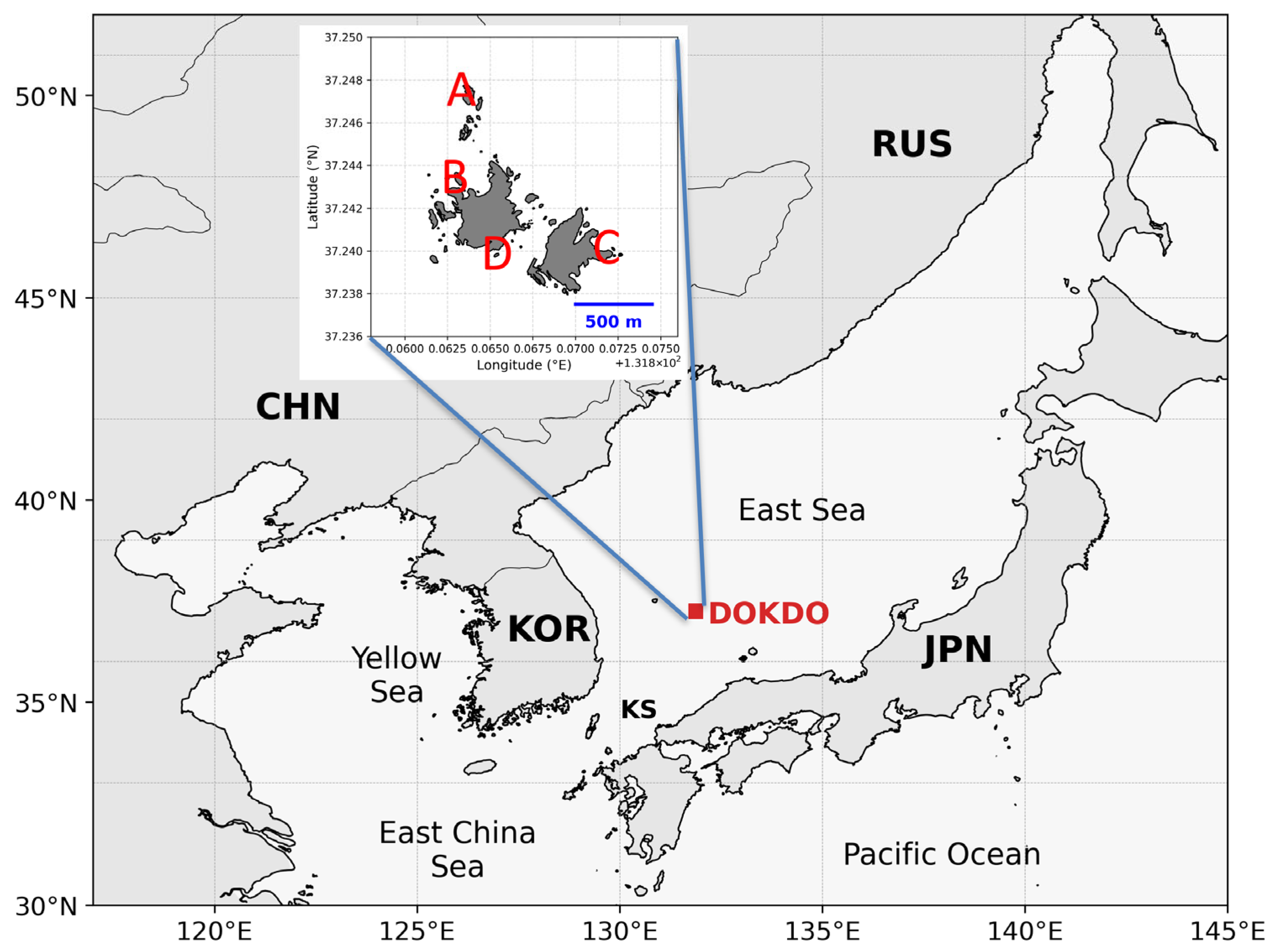
Despite its significant ecological, geographical, and political value, the Dokdo Island remains physically inaccessible to the general public and researchers alike [1,2]. In particular, the unique and biologically diverse underwater ecosystem surrounding Dokdo has not been fully utilized as a resource for public education or scientific communication due to spatial and temporal constraints [1,3]. Consequently, the demand for visual and digital technologies capable of effectively conveying information from limited-access environments has been steadily increasing [4]. Figure 1 presents the regional location of Dokdo within Northeast Asia, together with a zoomed-in inset highlighting the spatial extent of the study area used for immersive VR content development and digital twin visualization.
In recent years, there has been growing academic concern that many scientific findings—particularly in basic and publicly funded research—often fail to meet the standards of practical application, reproducibility, or societal relevance. Studies have shown that scientific research, although primarily funded by the public sector, often does not align with the needs of industry or the community [5,6]. For example, Abramo and D’Angelo [6] demonstrated that the transfer of publicly funded research into industrial applications remains limited, not because of a lack of intrinsic value, but due to systemic barriers such as inadequate translation mechanisms and contextual accessibility. Similarly, large-scale meta-research projects such as the Reproducibility Project have revealed that even high-profile scientific publications often fail to be replicated, and therefore struggle to influence real-world decision-making [7]. Furthermore, in fields such as environmental science and marine data analytics, many valuable datasets remain underutilized or difficult to interpret due to the absence of tools that bridge scientific data with operational or policy frameworks [8]. These challenges highlight the need for integrative frameworks that not only generate knowledge but also ensure its usability, transparency, and communication to both experts and non-experts. This gap in science communication and policy application is particularly acute in critical areas, such as marine science, directly impeding the achievement of Sustainable Development Goal (SDG) 14, which aims for the conservation and sustainable use of ocean resources [9]. In this context, environmental sustainability assessment refers to the role of immersive digital technologies in reducing physical disturbance, supporting conservation-oriented access, and enabling long-term data-driven management of ecologically sensitive marine environments.
Recent advancements in Virtual Reality (VR) and 3D modeling technologies have enabled immersive experiences of otherwise inaccessible environments, emerging as powerful tools for visually communicating complex spatial information [10,11]. VR technologies have demonstrated their ability to enhance spatial visualization, increase user engagement, and yield positive learning outcomes in various educational, training, and public outreach contexts [10,11]. Additionally, Digital Twin technologies provide precise digital representations of physical systems, supporting simulation-based research, environmental monitoring, and the development of adaptive management strategies [12,13,14]. According to McKinsey & Company [12], digital twins extend beyond visualization by enabling predictive decision support and asset management. The European Union’s “Destination Earth” initiative, for example, aims to build a digital twin of the entire planet to support climate modeling, forecasting, and adaptation planning [13,15]. Similar approaches are now being integrated into smart ports and coastal cities, integrating real-time environmental data with simulation-based engineering and policy design [14].
Such technological approaches gain value not solely through visualization but through practical application and integration into decision-making frameworks. In this context, immersive visualization technologies such as VR and digital twins are not just communication tools, but potential mediators between raw scientific insight and applied human action. This study applies these technologies to the unique spatial context of the Dokdo Islands to realize their integrated value across education, research, and conservation.
Previous research has demonstrated that transforming localized ecological data into VR content enhances educational effectiveness, while visualizing ecological datasets through digital twin platforms facilitates collaborative scientific inquiry [3,16,17]. For example, immersive content creation using marine biological information [3], photogrammetry-based indoor and outdoor terrain reconstruction [16], and digital twin simulations of urban environments [17] align closely with the technological direction of this study. These studies generally aim to increase public engagement, research efficiency, and policy applicability through immersive spatial reconstruction. This paper builds on that trajectory by focusing on the uniquely constrained environment of Dokdo.
This study, based on ecological and topographical datasets accumulated through government-supported research, aims to (1) develop VR content of the underwater ecosystem for public education and (2) construct a digital twin platform that provides a practical research environment for scientists. Section 2 provides a review of related work, followed by the implementation and methodological details of the proposed strategies in Section 3. Section 4 presents actual case applications derived from the project results, and Section 5 discusses the long-term research roadmap and the broader scientific and educational value of promoting public awareness of Dokdo through immersive digital media.

2. Related Works

2.1. Overview of Existing Research and Utilization Strategies Related to Dokdo

2.1.1. Biodiversity Studies

The area surrounding the Dokdo Islands is recognized as a biologically rich marine environment due to the intersection of cold and warm ocean currents. Ecological surveys conducted over several years have reported the presence of more than 500 species of fish, invertebrates, and marine algae. Moreover, depending on the year of monitoring and the specific methods used, additional biological communities have been identified, indicating even greater species diversity [18,19]. In particular, long-term studies conducted by multiple institutions, including the Korea Institute of Ocean Science and Technology (KIOST) and the National Institute of Fisheries Science (NIFS), have significantly contributed to the quantitative accumulation of ecological knowledge concerning Dokdo.
However, this extensive biological information remains fragmented due to inconsistencies in the timing of data collection, survey methodologies, and taxonomic classification systems. Consequently, both the general public and researchers face challenges in intuitively understanding and utilizing the ecological characteristics or spatial distribution of specific species. For example, representative fish species of the Dokdo marine ecosystem are only sporadically mentioned in individual publications or survey reports, and have rarely been transformed into visual resources or integrated databases [20,21].
To address this issue, digitizing and reconstructing existing biodiversity datasets into visual formats and further expanding them into 3D modeling and virtual reality (VR) content can serve as a powerful foundation for enhancing science communication regarding the Dokdo ecosystem. Such visualizations are not only applicable as educational tools but can also serve as platforms for comparative ecological analysis and long-term monitoring of environmental changes.
In this context, standardization refers not to the homogenization of numerical data, but to the unification of taxonomic classifications, normalization of descriptive attributes, and spatial linkage of species information for integration into a digital twin–based visualization framework.

2.1.2. Submarine Topography Studies

The Dokdo marine area is characterized by complex and rapidly changing underwater topography, necessitating the use of various high-resolution imaging techniques to understand the geological features of the seabed and their relationship with the surrounding marine ecosystem. For instance, depth data acquired through multi-beam echosounders, real-time underwater video captured via remotely operated vehicles (ROVs), and 3D reconstruction technologies based on photogrammetry have enabled detailed observations of specific underwater structures such as caves, rock formations, and erosion zones [22,23].
However, these visual and spatial datasets vary significantly in terms of collection objectives, equipment specifications, and metadata structures, making it difficult to manage them in an integrated manner. In most cases, the data are not accessible to the general public and are seldom used beyond specific research purposes.
To address this gap, the present study selects key segments of previously acquired exploration footage that possess both high visual quality and ecological relevance. These segments are reprocessed into 360-degree VR video content to provide immersive experiential environments. Such VR-based materials have a wide range of potential applications, including underwater exploration education, experiential learning in science museums, and the development of digital instructional platforms.
Accordingly, standardization in this domain focuses on reprocessing heterogeneous visual datasets into consistent immersive formats with unified metadata structures suitable for Web-based VR environments.

2.1.3. Geological Change Studies

Dokdo is a volcanic island that has undergone a geologically unique formation process and continues to evolve due to various natural factors, including coastal erosion, sea level rise, and weathering. In response to these ongoing changes, numerous public institutions and academic organizations have conducted long-term monitoring using aerial and satellite imagery, aerial photography, light detection and ranging (LiDAR) scans, and digital elevation models (DEMs) to trace the island’s geomorphological transformation over time [24,25]. Despite the availability of multi-temporal data, comprehensive analysis remains difficult due to inconsistencies in coordinate systems, resolution disparities, and differing analytical objectives among datasets.
Furthermore, most existing 3D terrain data represent only static replicas at a single point in time. They fall short of enabling time-series comparisons, identifying drivers of geomorphic changes, or supporting predictive simulations that could inform policy-making. To address these limitations, the present study aims to refine, standardize, and integrate the existing geospatial datasets into a unified digital twin structure. This framework can serve as a foundational platform for practical applications such as disaster preparedness, ecological restoration, and strategic policy development.
In this study, standardization involves harmonizing coordinate systems, spatial resolutions, and temporal references to enable integration of multi-source geospatial datasets within a unified digital twin structure.

2.2. Studies Utilizing Virtual Reality (VR)

Virtual Reality (VR) technology enables indirect experiences of physically restricted or difficult-to-access environments and has been actively applied in fields such as education and cultural heritage preservation. In a systematic review of VR applications in higher education, Radianti, Majchrzak, Fromm and Wohlgenannt [10] found that immersion and interactivity have a positive influence on learning outcomes and conceptual understanding. Their findings indicate that VR content can serve as a practical substitute for laboratory experiments and field-based learning across various disciplines, including engineering, medicine, and the natural sciences.
In the marine domain, VR models were developed for the preservation of underwater cultural heritage [26]. By utilizing photogrammetry techniques, they generated highly detailed 3D models of submerged sites and constructed immersive VR environments. The study demonstrated that such visual restoration could be achieved with high realism and was effective not only for educational purposes but also for long-term conservation and public engagement. Similarly, historical architecture has been recreated in VR using photogrammetry, with high user satisfaction reported in terms of immersion and the perceived value of digital preservation [27].
These studies collectively suggest that VR can offer alternative experiences in environments that are physically inaccessible and that its applications extend beyond visualization to encompass education, cultural communication, ecology, and industrial training. Based on these technological developments, the present study employs VR methods in the unique marine environment of Dokdo, providing a new empirical case of immersive ecological representation.

2.3. Application of Digital Twin Technology

Digital twin technology enables the precise digital replication of physical objects or systems, allowing for real-time monitoring, simulation, analysis, and predictive modeling. A digital twin-based design and service model was proposed in the manufacturing sector, demonstrating the potential for optimizing product life cycles through physical-digital interaction [28]. Their study showed that digital twins have evolved beyond mere 3D representations, integrating real-time sensor data and simulation algorithms to form complex and dynamic systems.
Recent research has emphasized the need for a unified conceptual and technical framework to integrate multidisciplinary coastal information for advanced decision-making. For example, a Coastal Zone Information Model (CZIM) has been proposed as a research-oriented architectural framework to support the development of coastal digital twins by organizing coastal data, models, and domain knowledge within a unified digital system. In this context, data governance refers to the standardization and coordination of data structures, metadata, and model interoperability, rather than to a government policy or legally defined zoning system. The CZIM framework emphasizes key components, including coastal data governance, model integration, knowledge engineering, and system architecture, to facilitate intelligent and adaptive responses to dynamic coastal environments [29]. Similarly, conceptual and practical gaps have been analyzed in the implementation of city-scale digital twins, with a particular emphasis on data integration challenges across urban systems and their implications for smart city development [30].
Digital twin technology was implemented in landscape architecture education by creating a learning platform where students could design, analyze, and simulate using real terrain data [31]. The system was found to enhance student engagement, creativity, and collaborative skills, showcasing the potential of digital twins as educational platforms. In addition, Lim et al. [32]. studied a marine disaster prediction simulation system utilizing marine tech that combines marine science and digital twins, suggesting the possibility of convergence research between IT and the marine field. In another domain, a digital twin framework has been proposed for river basin management, integrating real-time sensor data with hydrodynamic simulations and machine learning models. Their approach enables proactive flood mitigation, water resource optimization, and informed decision-making in complex hydrological environments [33].
These approaches collectively demonstrate the feasibility of using digital twins as tools for ecosystem management. These examples collectively illustrate the multifaceted development of digital twin technology across domains, encompassing physical-digital integration, simulation-based decision-making, and educational and training environments. The present study aims to apply this framework to the Dokdo region, examining its potential as both a scientific tool and a public educational resource. Accordingly, CZIM is referenced in this study as a conceptual guide for system architecture and data integration, rather than as a spatial zoning scheme defining management boundaries.

3. Proposed Method

This study aims to develop two integrated outputs: (1) an immersive virtual reality (VR) content system that enables the general public to indirectly experience the underwater ecosystem of Dokdo, a region with limited physical accessibility, and (2) a digital twin platform that serves as both a scientific visualization tool and an integrated data management system for researchers. The proposed development process is based on a previously established underwater healing content framework [34,35], but has been adapted to reflect the unique geomorphological and ecological characteristics of the Dokdo region, with particular consideration given to its potential for scientific application.
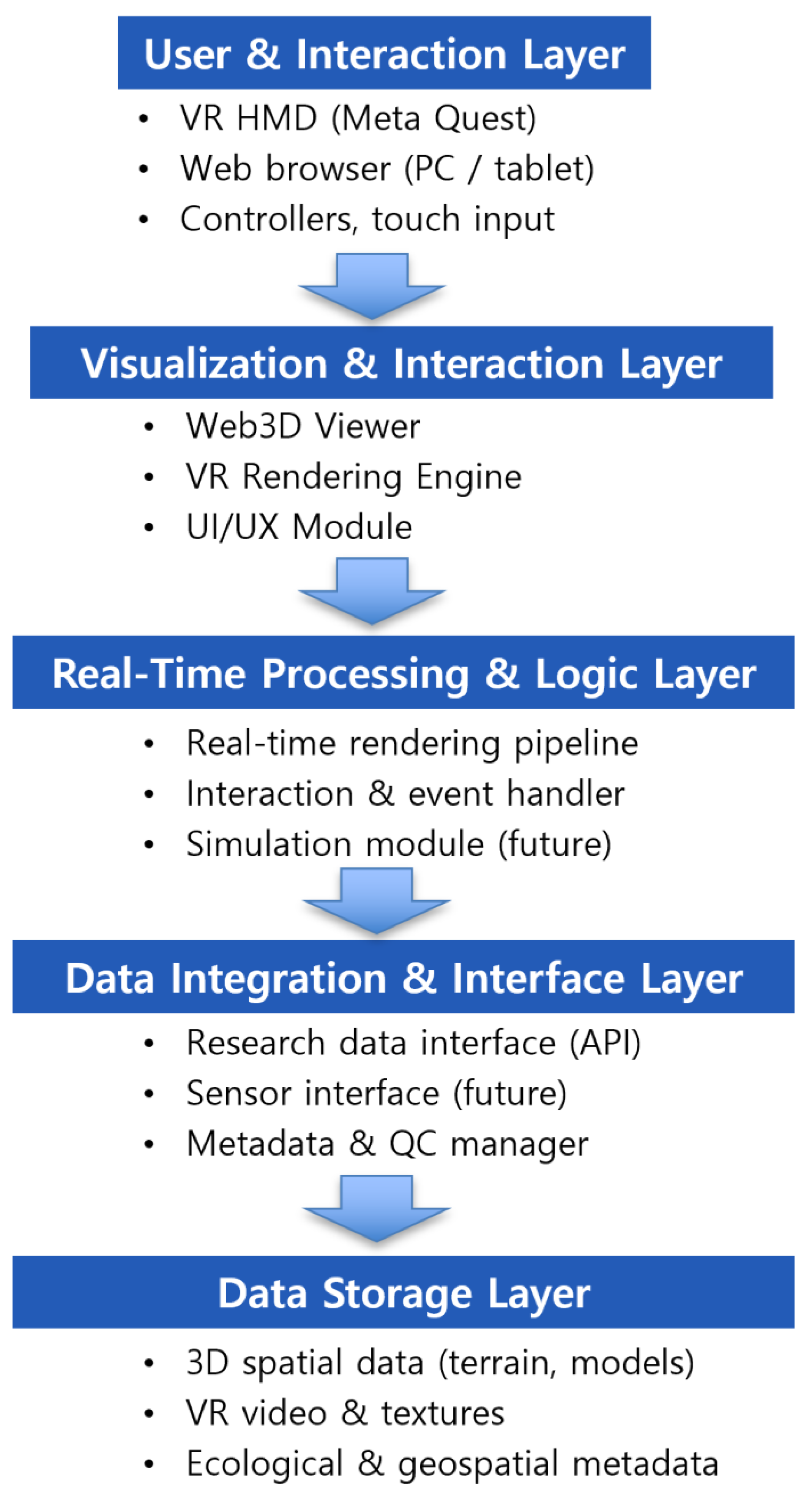
This study presents a digital twin and virtual reality (VR)-based visualization methodology designed to meet three major criteria: scientific applicability, public accessibility, and industrial applicability. Figure 2 presents the overall system architecture of the proposed Web3D-based Dokdo digital twin platform, including the data storage structure, real-time interaction pipeline, and extensible interfaces for future sensor integration and simulation functions. To guide the selection of core technologies prior to content development and system implementation, the suitability of the VR device (Meta Quest), the 3D reconstruction technology (Smart 3D Capture and 3D Gaussian Splatting (3DGS)), and the web-based spatial expression framework (Web Graphics Library, WebGL) was comparatively analyzed by referring to real-world empirical research and industry applications [36,37,38,39,40]. The technology comparisons were conducted based on the following criteria.
  • Scientific applicability
VR and digital twin platforms, such as Meta Quest, have been proven to enable immersive and high-precision 3D visualization of complex environmental datasets, including climate, ocean, and ecological data, thereby supporting simulation, synchronization, and scalability in domains like urban and marine environments. Smart 3D Capture and 3DGS are state-of-the-art technologies for generating ultra-high-precision 3D models from aerial and ground images. Compared to conventional photogrammetry, they achieve GSD 0.03 m/pixel-level precision and real-time rendering (>100 FPS) simultaneously, providing exceptional performance for scientific visualization of complex terrain [40]. WebGL enables the real-time rendering of scientific data within browser environments, providing seamless extensibility through Application Programming Interface (API) integration and making it highly suitable for real-time simulation and multidomain connections.
  • Public accessibility
Commercial VR devices, such as Meta Quest, demonstrate broad accessibility due to their high prevalence and intuitive user interfaces, and are widely adopted for education, citizen science, and public outreach. 3DGS-based rendering can deliver high-quality 3D content in real-time through web browsers without complex post-processing, enabling the general public to access immersive spatial experiences without additional software installation. The web-based nature of WebGL ensures that high-quality interactive 3D content is accessible without the need for expensive hardware, enhancing its use in educational and public applications.
  • Industrial applicability
Digital twin and WebGL-based real-time visualization platforms are actively employed in various industrial settings for activities such as complex system monitoring, predictive maintenance simulation, and environmental decision-making. The integration of APIs enables straightforward interconnection with external sensors and live data streams, facilitating rapid and efficient system deployment and scalability across various industrial domains.
The Table 1 below summarizes the results of a comparative analysis of Meta Quest, Smart 3D Capture and 3DGS, WebGL, and alternative technologies based on the three evaluation criteria of scientific applicability, public accessibility, and industrial applicability.
Rather than serving single purposes, these three core technologies are designed to be combined adaptively, allowing users across various domains—researchers, educators, and industry stakeholders—to benefit from the integrated platform. Meta Quest was selected for its strength in delivering immersive experiences and facilitating outreach and educational tasks supported by large-scale case studies and practical implementations. Smart 3D Capture and 3DGS were selected for their ultra-high-precision 3D reconstruction at GSD 0.075 m/pixel level, real-time rendering support (>100 FPS), and their capability for precise visualization of complex terrain [40]. WebGL was adopted for its web-based, real-time 3D rendering capabilities, which do not require high-end hardware, as well as its ability to integrate external data for the construction and expansion of digital twin platforms in industrial contexts.
Notably, by leveraging these technologies, recent studies have demonstrated advanced applications such as real-time urban flooding management using digital twins and animated geospatial data visualization for maritime monitoring, highlighting the broad versatility and scalability of this methodological combination.

3.1. Subsection Development of VR Content Based on Dokdo’s Research Results

3.1.1. 360-Degree Underwater VR Filming and Post-Processing

To vividly reproduce the underwater ecosystem and marine environment surrounding Dokdo, a series of 360-degree VR video recordings was conducted. The primary objective of this activity was to produce immersive content that enables the general public, academic community, and educational institutions to virtually experience the unique underwater environment of Dokdo. The video data collected through this process are intended to serve as visual educational material that effectively communicates the natural characteristics of Dokdo to a broader audience. Due to its geopolitical sensitivity and ecological importance, access to Dokdo’s waters is severely restricted for the general public, with only limited seasonal and spatial permissions granted for visitation. Despite widespread public interest in the region from historical and geographical perspectives, opportunities for direct experience remain extremely limited. Consequently, immersive VR technologies were identified as an effective medium for bridging this experiential gap.
In this study, VR content was developed to communicate research outcomes and enhance public engagement with Dokdo’s natural environment. The first step in this process involved underwater filming, as described below.
  • Equipment Preparation and Configuration
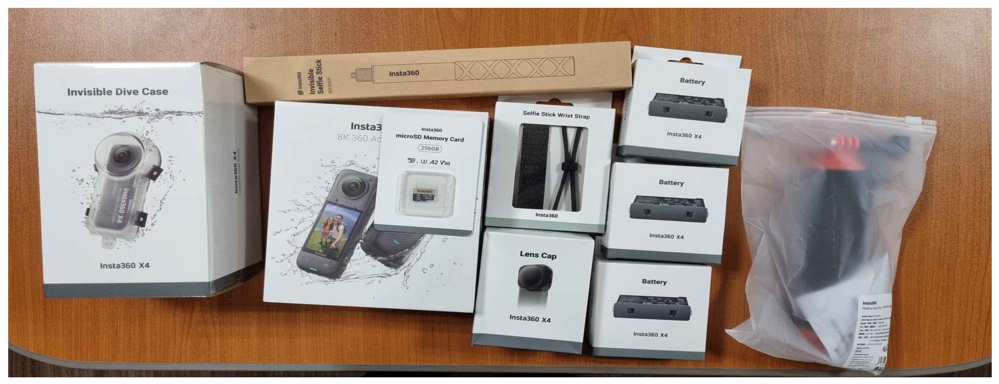
To realistically and spatially capture the underwater environment of Dokdo, an Insta360 X4 VR camera (Insta360 Inc., Shenzhen, China), capable of recording 360° video at up to 8K resolution and 30 frames per second, was employed. This device is inherently waterproof up to a depth of 10 m. When equipped with the dedicated dive case and dive kit (Figure 3), it can operate safely at depths of up to 50 m. To ensure stable image capture under the challenging conditions of underwater shooting, key features such as FlowState stabilization and 360° Horizon Lock were utilized to minimize motion blur and distortion caused by water movement. However, underwater videography presents inherent challenges due to variable light absorption and scattering, which depend on water depth and environmental conditions. Even within a single continuous recording, brightness levels often fluctuate significantly. To mitigate this, camera settings—including exposure and resolution—were carefully adjusted in advance to ensure consistent image quality throughout the dive. The camera was configured to withstand the physical pressures and lighting variations encountered in underwater environments, ensuring clear visualization of the surrounding seascape. These preparations enabled the collection of high-quality footage suitable for immersive VR content development and scientific visualization.
  • Site Selection and Safety Measures for Underwater Filming
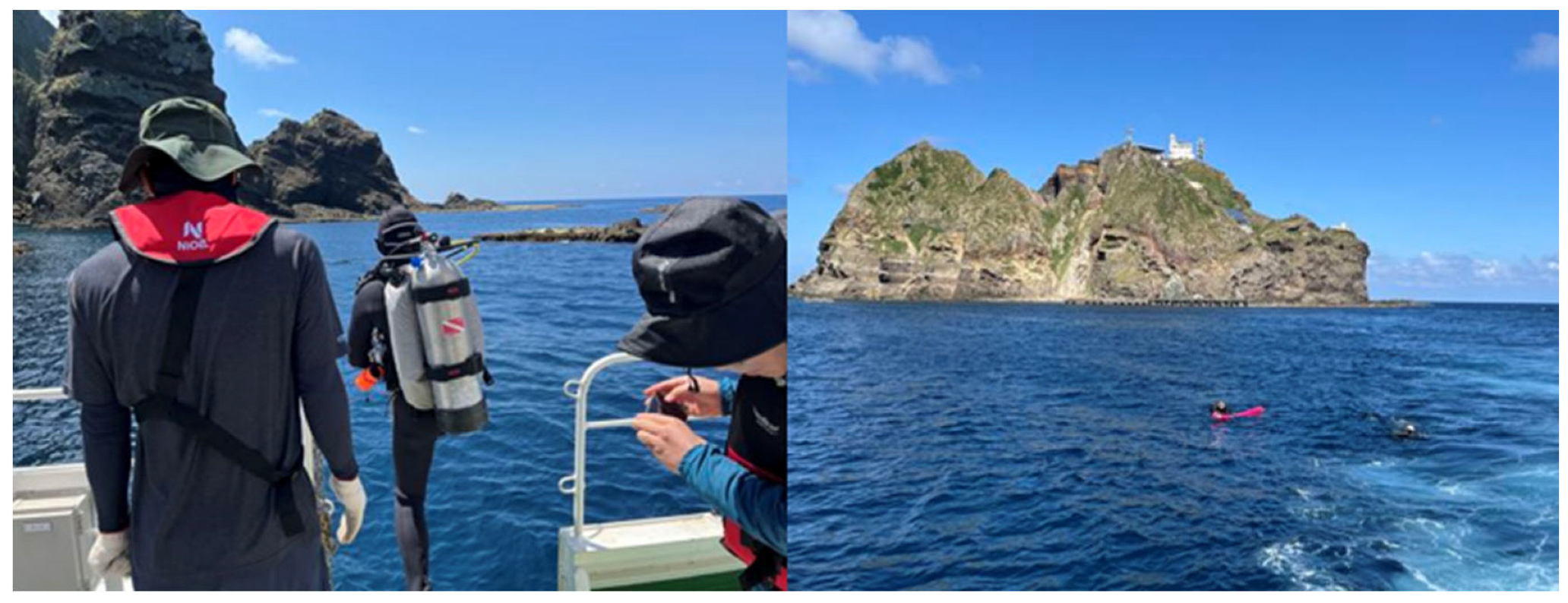
To effectively capture the representative characteristics of Dokdo’s underwater ecosystem, multiple shooting locations were selected based on ecological diversity and spatial variation. As shown in Figure 4, underwater filming was carried out by a team of two certified professional divers per site. For safety, a surface marker buoy was deployed at each dive entry point, and a support vessel remained within a few meters of the divers throughout the operation. These precautions ensured stable filming conditions and diver safety in the dynamic marine environment.
  • 360° Underwater VR Filming
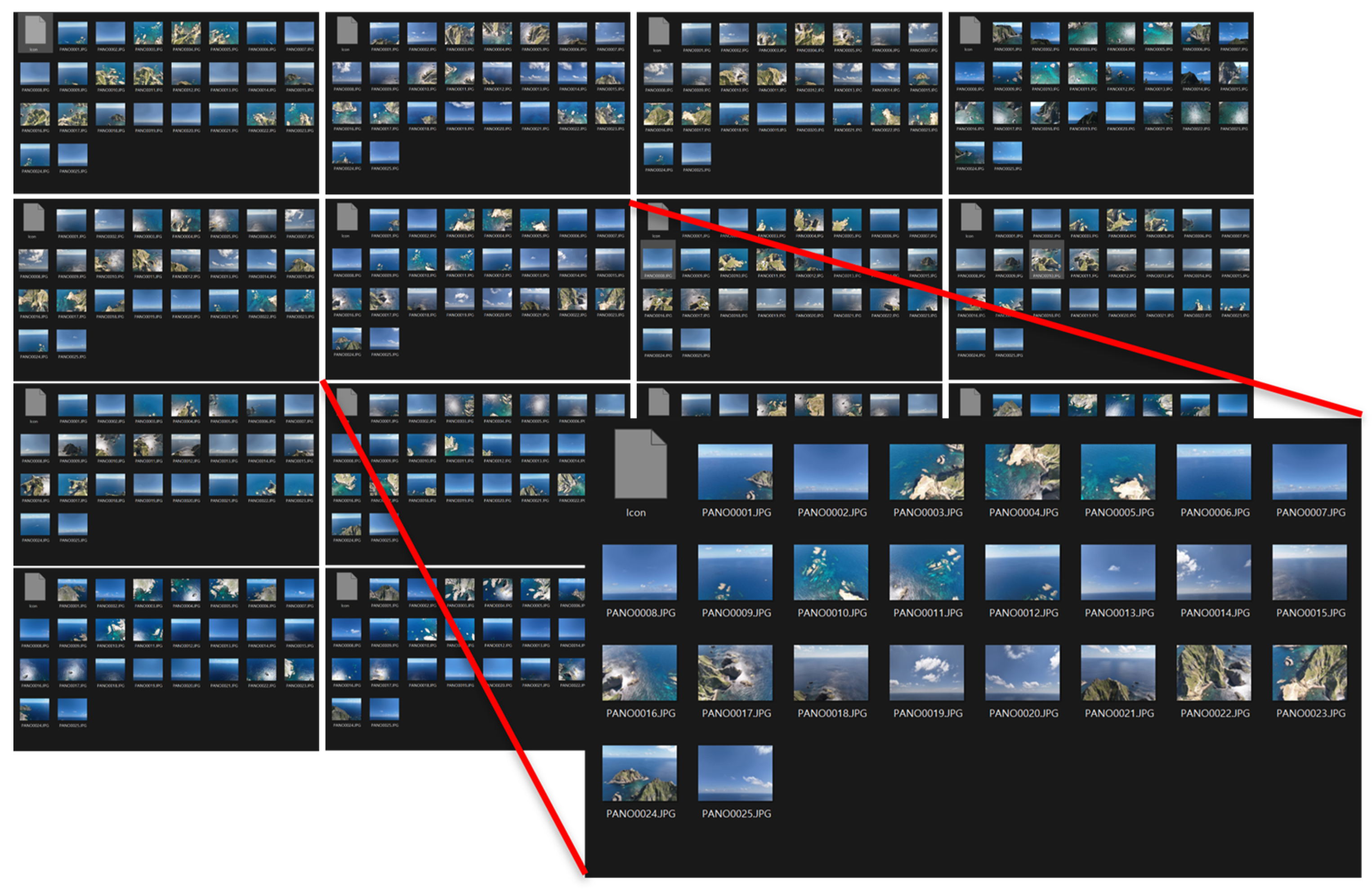
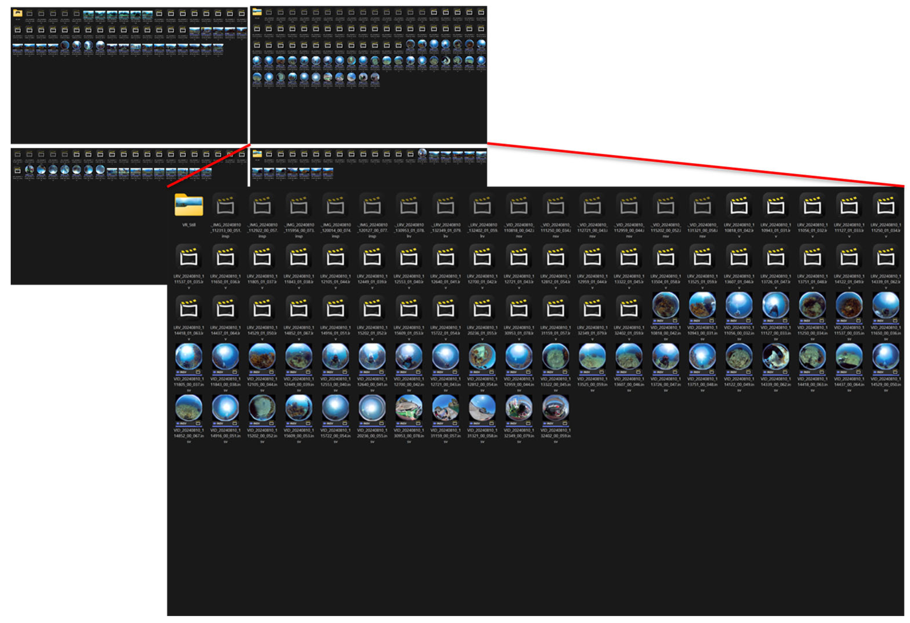
To comprehensively document the underwater ecosystem, stabilization equipment was employed to mitigate shaking caused by ocean currents. Exposure settings were dynamically adjusted according to underwater light conditions during filming, and multiple angles were captured to ensure visual completeness. Filming was conducted under a detailed plan that took into account the habitats and movement patterns of marine organisms, enabling the camera to capture a wide range of ecological elements effectively. As a result, underwater footage was successfully obtained, as shown in Figure 5. A summary of the number, duration, and characteristics of the collected videos is presented in Table 1.
  • Post-Processing and Data Correction
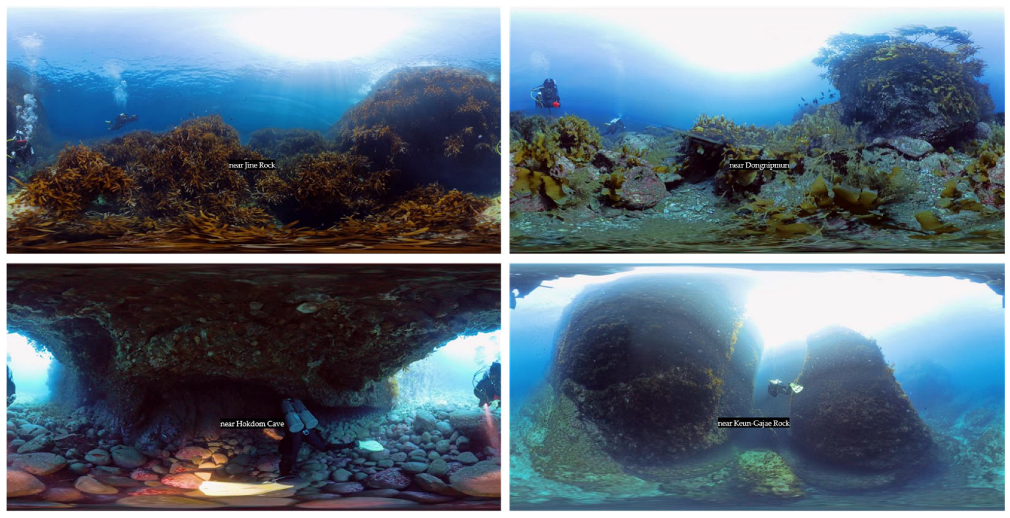
The recorded 360-degree VR footage was post-processed using 3DGS to perform stitching, seamlessly integrating multiple video segments into a single cohesive VR experience. During this process, color grading and brightness adjustments were applied to correct variations in color and brightness between different scenes, ensuring visual consistency throughout the content. As a result, high-fidelity and visually coherent 360-degree VR footage was produced, as shown in Figure 6.

3.1.2. Content Development of Dokdo Marine Life Using 3D Modeling

To enhance the realism and immersive experience of the VR content, high-resolution 3D high-polygon models were created for representative marine species inhabiting the coastal waters of Dokdo. The modeling process was guided by ecological characteristics specific to the local marine environment, ensuring that the visual representation of marine organisms in VR and Web 3D platforms would be both scientifically accurate and visually compelling.
  • Selection of Target Species and High-Polygon Modeling
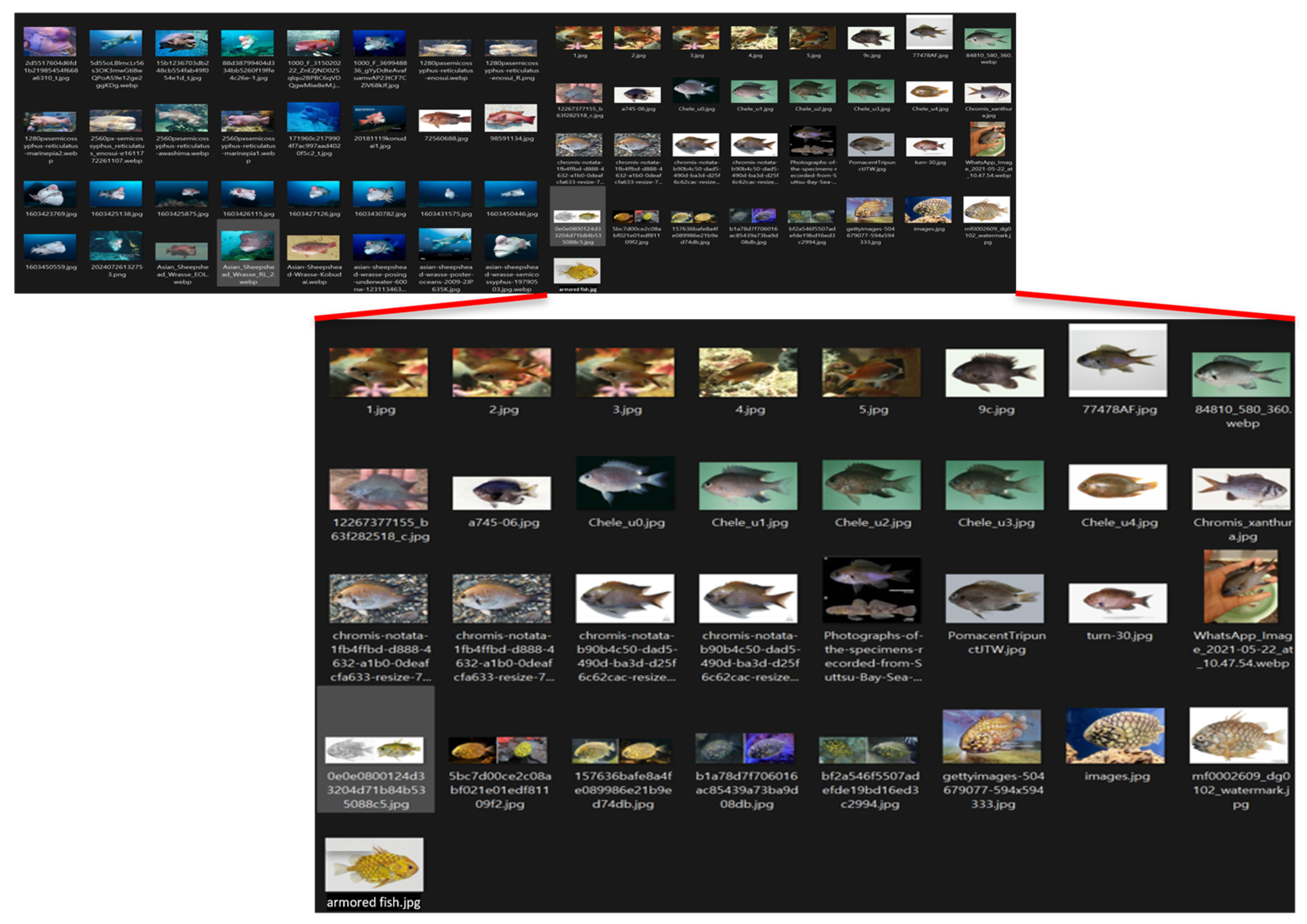
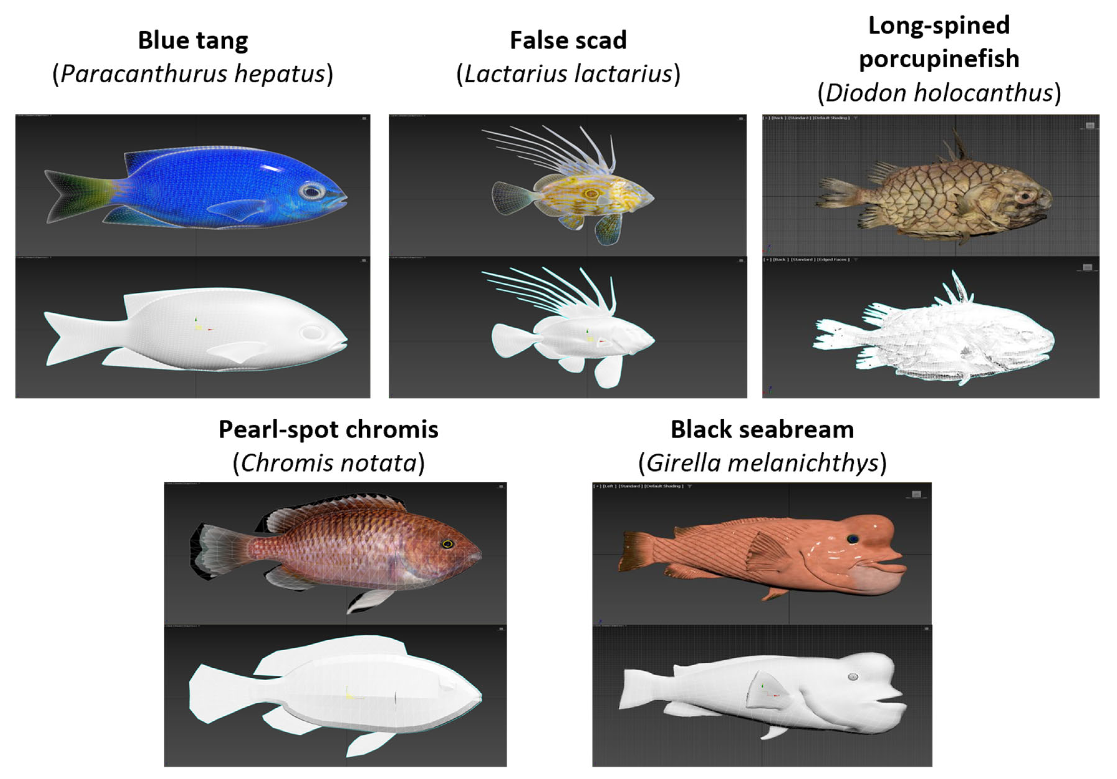
At the initial stage of the project, five representative fish species inhabiting the waters surrounding Dokdo were selected, as illustrated in Figure 7. The selection was based on prior ecological studies of the region [20,21]. Detailed morphological data, including body shape, coloration, and average size, were collected for each species. This process enabled the precise definition of the characteristic features of the target organisms for subsequent 3D modeling.
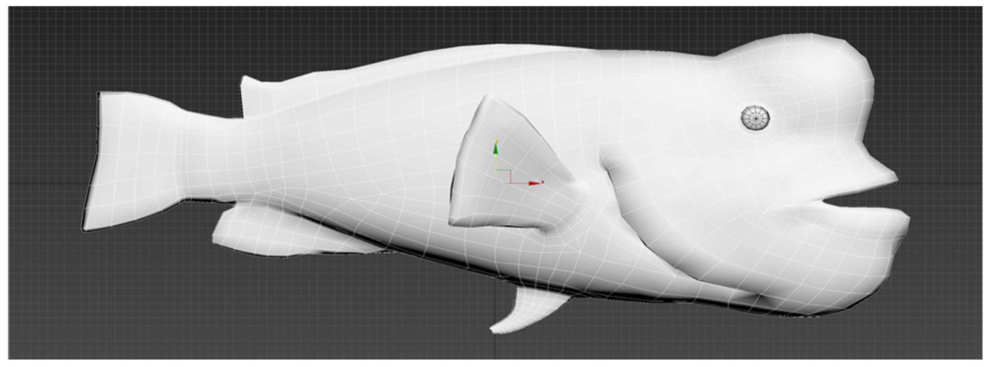
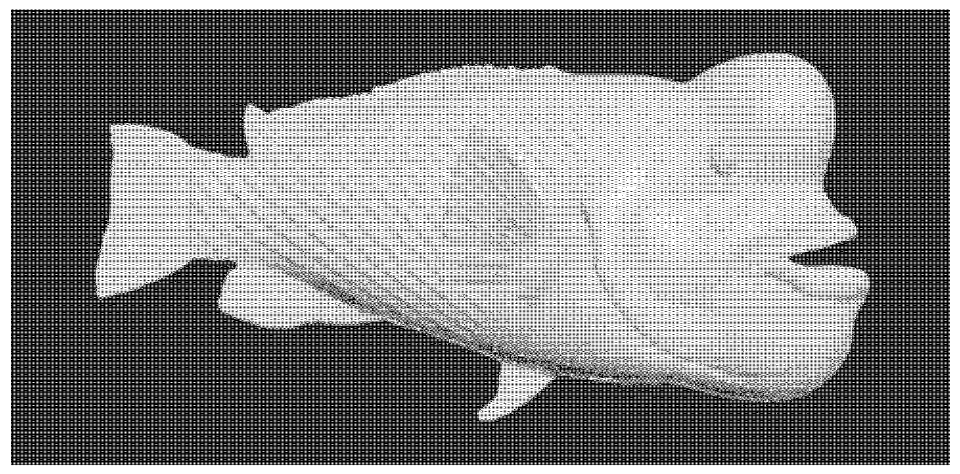
Following the selection and definition of key characteristics for each species, 3D modeling was conducted to capture the organisms’ natural curves and fine surface details. As shown in Figure 8, high-density polygon meshes were used to accurately replicate intricate features, including skin texture, scales, and fins. This level of detail plays a crucial role in reducing visual dissonance between the 3D models and real underwater footage, thereby enhancing user immersion. The current study focused on the precise implementation of these biological elements, with plans for future validation of model quality through compositing with actual site footage captured in the Dokdo marine environment.
  • Optimization of 3D Models through Retopology
High-resolution 3D models created using high-polygon modeling techniques offer a high level of realism by accurately representing the subject’s detailed characteristics. However, such models often cause extended processing times and texture mapping errors during rendering and UV mapping in the content production workflow. The retopology process is employed to optimize the polygon count of 3D models of Dokdo’s marine species, thereby enhancing real-time rendering performance.
In this study, high-polygon models were analyzed for polygon density and structural complexity, and then converted into low-polygon structures to maintain detailed features while ensuring smooth operation in VR and Web 3D environments. The retopology was conducted in two phases: first, automatic retopology was applied to preserve the overall silhouette of each model while standardizing polygon distribution; second, manual retopology was carried out to refine essential details such as the eyes, fins, and tail. Figure 9 presents the results of the retopology process.
  • UV Mapping
After the retopology process, UV mapping was performed to apply detailed texture information to the simplified 3D models. UV mapping refers to the process of unwrapping a 3D surface into a 2D plane and generating UV coordinates. These coordinates serve as a reference for accurately placing and aligning texture maps on the surface of a 3D model to express fine details such as texture, color, and patterns.
Once UV mapping was completed, the texturing process was carried out. Through this step, realistic visual features such as coloration, natural patterns, and micro-textures were applied to the five selected species of fish native to the Dokdo waters. High-resolution textures were used to enhance the visual fidelity of the models, resulting in a natural and immersive representation suitable for VR and Web 3D environments. Figure 10 shows the results.
  • Validation of Biological Morphology and Environmental Accuracy
To ensure biological and environmental realism in the immersive VR environment, a qualitative validation procedure was applied to both 3D marine life models and virtual scene composition. The morphological consistency of the 3D models was evaluated through expert-based visual inspection, utilizing authoritative taxonomic descriptions and reference imagery from prior ecological studies conducted in the Dokdo region. Key attributes, including overall body shape, fin structure, coloration patterns, and relative size, were examined to ensure consistency with documented species characteristics.
Geographic and ecological accuracy of the VR scenes was validated by cross-checking virtual terrain geometry, spatial orientation, and habitat representations against authoritative geospatial datasets, field observations, and relevant scientific literature. This process ensured that the immersive environment accurately reflects real-world geographic and ecological conditions while remaining optimized for visualization and digital twin–oriented applications. Quantitative validation of biological morphology and ecological processes will be addressed in future studies through integration with sensor data and ecological modeling frameworks.

3.2. Web 3D-Based Virtualization of Dokdo

This study aims to develop a digital twin framework based on research data from the Dokdo region, focusing on the initial stage of virtualization through spatial replication. Spatial replication refers to the construction of a virtual environment by replicating a real-world location using methods tailored to specific application purposes. This approach enables simulations and visualizations to reflect the real environment as closely as possible, thereby enhancing user comprehension and spatial awareness. In this work, we implemented a foundational digital twin prototype of Dokdo by acquiring aerial images and performing 3D mapping to construct the virtual space and establish data integration functionalities.
The virtualization process was conducted in four main stages: (1) pre-setup and flight planning, (2) aerial photography using an RTK-enabled drone, (3) data processing and editing, and (4) virtual environment construction based on Novel View Synthesis. Each step was designed to ensure accuracy, consistency, and seamless integration into the digital twin framework, and the corresponding outcomes are described below.

3.2.1. Aerial Survey of Dokdo Using RTK Drone

Real-Time Kinematic (RTK) technology provides centimeter-level positional accuracy by correcting GPS signals in real time, which enables precise geolocation data alignment during the virtualization process. This precision is critical for simulating environmental and ecological changes in later stages of the digital twin and for ensuring scientifically reliable spatial representation.
In this study, we selected a total of 55 key aerial capture points around Dokdo to comprehensively document the island’s terrestrial and coastal landscapes from multiple perspectives. The main objective of the aerial survey was to acquire high-resolution, image-based topographic data suitable for constructing an accurate and realistic virtual representation of Dokdo.
  • Drone Setup and Flight Planning
We employed the DJI Matrice 4E drone for high-precision data acquisition. The introduction of the Matrice 4E enabled imaging with minimized shadow areas compared to the previous year, and Smart 3D Capture flight paths allowed ultra-close-range capture up to GSD 0.075 m/pixel at 1 m distance. Additionally, the ability to verify flight paths in 3D beforehand enabled detailed shooting plan development. Prior to the actual flights, calibration and system setup procedures were conducted. Unlike conventional GPS systems, which typically yield meter-level error margins, RTK technology enables position measurements with centimeter-level accuracy. This improvement is vital for enhancing the realism of future simulation outputs derived from the digital twin and for ensuring consistent geospatial fidelity.
  • Smart 3D Capture Flight Path Method
A comparison between the conventional 3D Mapping method and the new Smart 3D Capture method is as follows:
(1)
3D Mapping Method
-
Captures terrain in a grid pattern using only 2D routes
-
High-precision terrain production at sampling level
(2)
Smart 3D Capture Method
-
Generates 3D flight paths referencing terrain point cloud
-
Performs terrain capture optimized for shooting distance and quality
-
Enables ultra-high-precision terrain production at GSD 0.075 m/pixel level
  • Pre-preparation and Planning
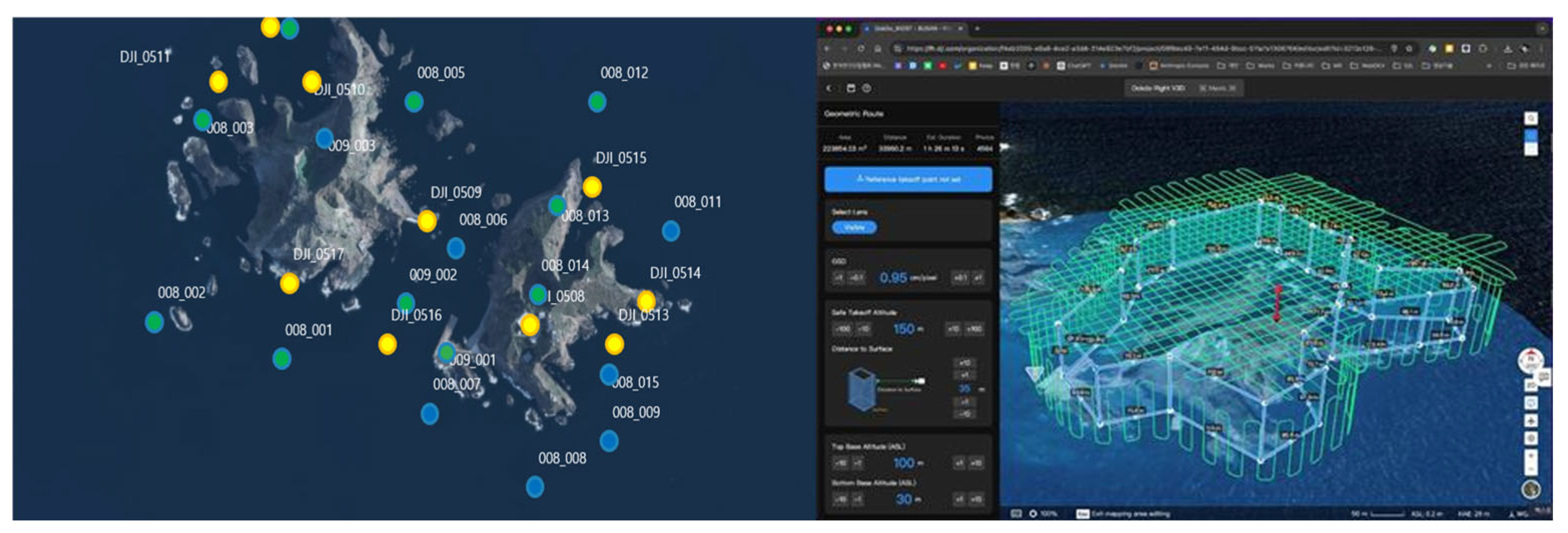
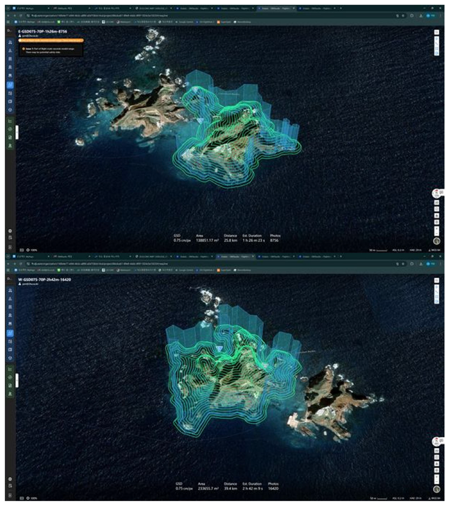
Prior to the main Dokdo imaging, Smart 3D Capture flight path generation and test imaging were conducted targeting Oryukdo Island. Through test imaging, the possibility of communication data shadow zones between the aircraft and controller during shooting was identified and supplemented with LTE communication. Additionally, RTK data from the National Geographic Information Institute was secured in preparation for cases where the drone enters blind spots and cannot receive GPS data in real-time. Using data acquired from test imaging, a 3D shape model was produced to complete pre-verification of the system and shooting methods before actual Dokdo imaging. These selections were made to ensure that the virtual environment reflects the ecological and geographical distinctiveness of Dokdo with high fidelity. Figure 11 shows a subset of underwater and aerial capture points, along with a portion of the planned flight routes for VR content creation. Figure 12 shows the generation of a 3D shape model using approximate flight altitudes for smart 3D capture flight-path planning.
  • Smart 3D Capture Flight Path Generation
Using imaging data acquired from preliminary shooting, a 3D shape model of Dokdo was generated for Smart 3D Capture flight path creation in Figure 13. As the target imaging area was extensive and exceeded the range of flight paths that could be generated at once, the area was divided into three zones (Dongdo, Seodo, Gajebawi), and flight paths were generated accordingly with corresponding shooting plans. Imaging was conducted in three sessions:
    • Preliminary imaging: 12–13 July 2025
    • Main imaging 1st: 8–10 August 2025
    • Main imaging 2nd: 23–25 August 2025
  • Aerial Imaging Using RTK Drone
During the aerial imaging phase, imaging was conducted along predetermined 3D flight paths. To emphasize the depth and dimensionality of the landscape, each site was photographed from multiple angles and altitudes. In addition to video data, detailed geospatial coordinates of the terrain were also acquired throughout the process. This ensured that each image could be accurately aligned, georeferenced, and integrated into the digital twin model. Figure 14 shows aerial image data of Dokdo acquired via RTK drone.
  • Smart 3D Capture Drone Imaging Results
Through Dokdo Smart 3D Capture imaging, approximately 93,021 images were acquired. The imaging results by zone are as follows:
    • Dongdo: GSD 0.75, imaging time 1 h 26 min, 15,607 images
    • Seodo: GSD 0.75, imaging time 2 h 42 min, 34,480 images
    • Gajebawi: GSD 0.75, imaging time 1 h 56 min, 4098 images
    • Additional erosion zone imaging: 16,270 images
    • Other supplementary imaging: 22,566 images
  • Environmental Conditions and Imaging Parameters
Data acquisition was conducted under favorable summer weather conditions at Dokdo on 10–11 August 2024 and 8–10 August 2025. The survey period was characterized by predominantly clear to partly cloudy conditions, with daytime air temperatures ranging approximately from 23 to 31 °C. Seawater visibility during the survey was moderate to good, typical of summer conditions in the Dokdo area. Underwater visibility was sufficient for stable visual acquisition of coastal features and benthic environments using underwater VR cameras, with no reported turbidity events that significantly degraded image quality. Imagery was acquired primarily under natural sunlight, with minimal cloud cover during most shooting periods. These conditions provided adequate ambient illumination for both aerial (drone-based) and underwater imaging, reducing the need for artificial lighting and supporting consistent color and texture capture. All underwater imagery was collected at shallow depths not exceeding 10 m, ensuring sufficient light penetration and stable optical conditions for high-resolution underwater video and 3D content generation. These environmental conditions were considered suitable for integrated drone photogrammetry, 3D laser scanning, and underwater VR imaging, and did not impose significant constraints on data quality or spatial coverage.

3.2.2. Dokdo Virtualization Using Aerial Imaging Data

  • Editing of Aerial Imaging Data
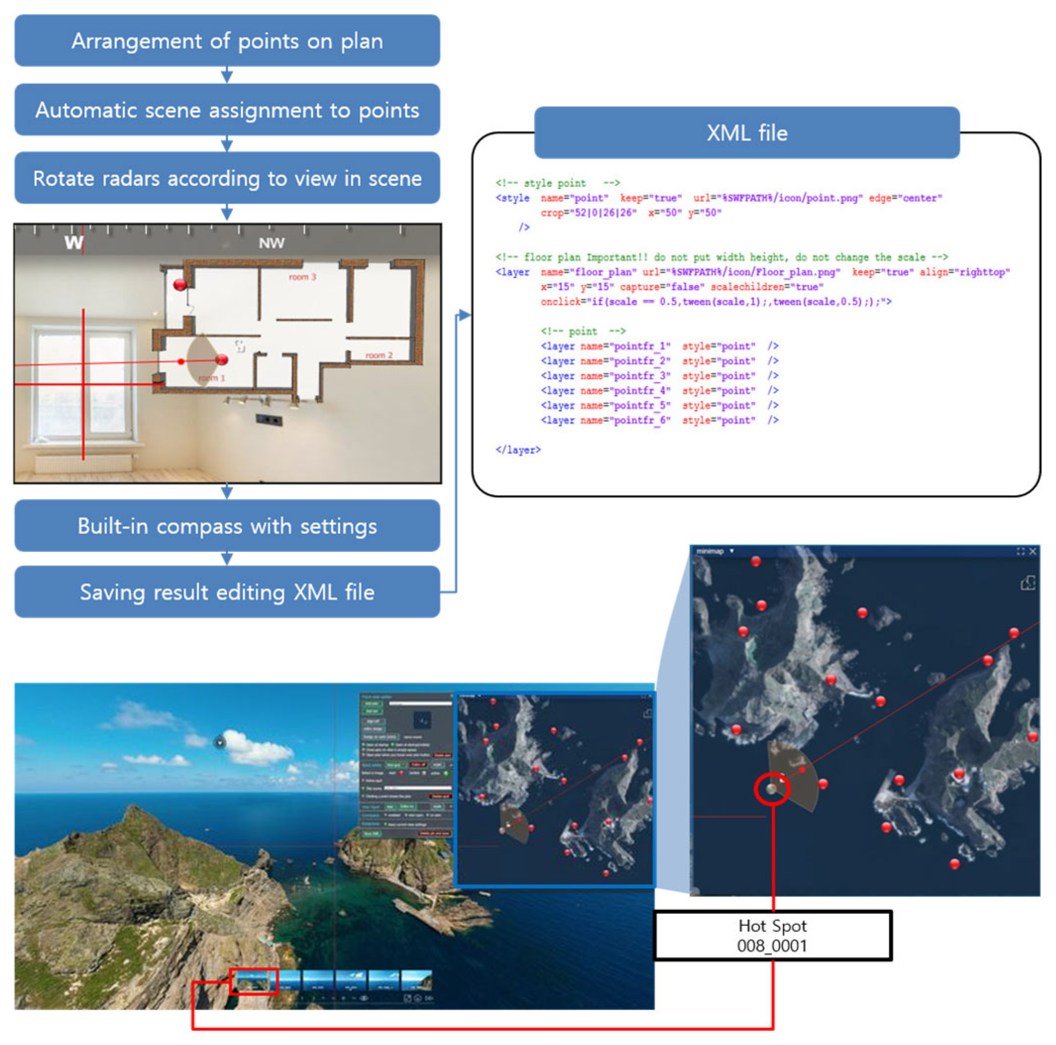
Prior to the virtualization process, the directional orientation of Dokdo was configured, as shown in Figure 15. This step was crucial for aligning virtual outputs with real-world geographic information, thereby supporting scientific analysis, environmental monitoring, and informed decision-making applications. As previously discussed, this calibration enhances the usability and reliability of subsequent digital twin studies involving Dokdo.
  • Web 3D-Based Virtualization
In this stage, aerial image data acquired and processed in the previous steps were used to construct a Web 3D-based virtualization, with two main objectives. First, to enable users to explore and better understand the island’s complex terrain and ecological features. Second, to establish a foundational platform that can later integrate sensor measurements and research datasets for use as a functional digital twin.
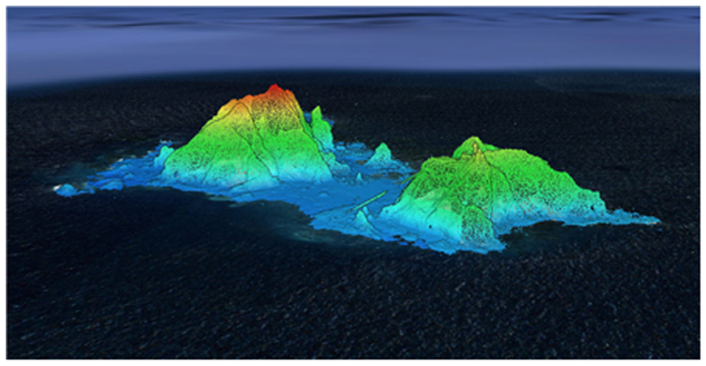
To achieve this, Novel View Synthesis technology was applied to the edited aerial image data. Novel View Synthesis is a computer vision technique that generates realistic images from new viewpoints using a limited number of input images. Recent advances in Neural Radiance Fields (NeRF) and 3DGS have achieved breakthrough performance improvements compared to traditional 3D shape model extraction methods in Figure 16.
  • 3D Model Optimization and Rendering Parameters
In this study, a 3DGS-based approach was utilized to optimize the following key parameters:
    • Adaptive density control: During training, Gaussians are split, cloned, and pruned to adaptively adjust the number of Gaussians according to scene complexity, achieving balance between memory efficiency and rendering quality [40]
    • Spherical Harmonics degree: Spherical Harmonics (SH) are used to model view-dependent appearance for representing reflection and lighting effects
    • Opacity and Covariance: The opacity and covariance matrix of each Gaussian are learned to precisely represent the geometric structure of the scene
  • 3DGS Training Environment and Results
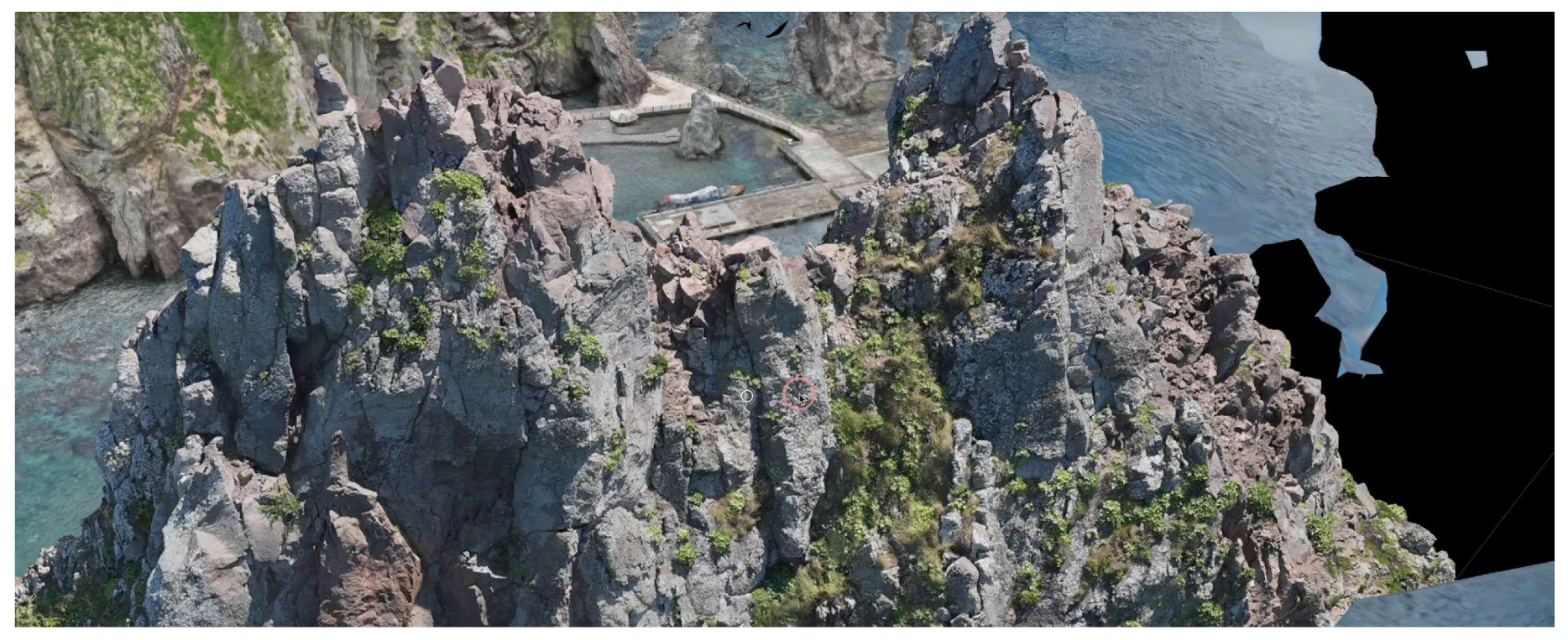
Two NVIDIA A6000 GPUs were utilized for training the 3DGS model of Dokdo. In the initial training phase, 1798 training images were used to generate approximately 5.53 million (5,539,347) point clouds, and training was performed for a total of 50,000 iterations, achieving 100% training progress. The trained 3DGS model represents Dokdo’s complex terrain and rock structures with high fidelity, generating an optimized set of Gaussian primitives capable of real-time rendering.
Currently, fine-tuning using approximately 54,000 high-resolution images is in progress for additional quality improvement. This fine-tuning is expected to supplement details in shadow areas, improve texture quality, and enhance consistency across viewpoint changes.
The 3DGS technique has the advantage of achieving both real-time rendering speed (>100 FPS) and high visual fidelity compared to conventional NeRF, making it particularly suitable for interactive visualization in Web 3D environments.
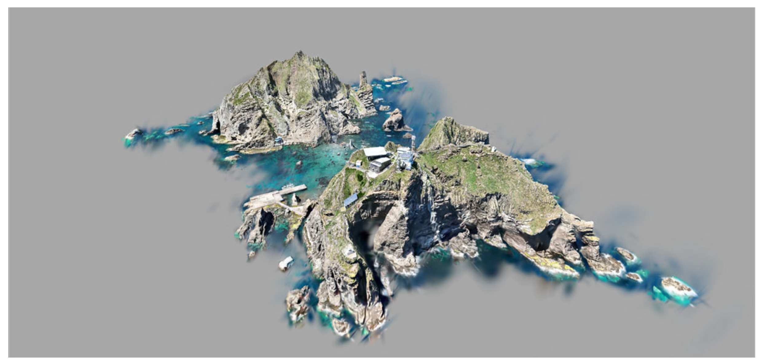
Although RTK drone imaging captured a wide range of visual information across Dokdo, this technique was utilized to supplement missing or visually incomplete terrain details, thereby improving the overall fidelity of the virtual environment. Novel View Synthesis calculates depth from multiple overlapping images to generate unseen perspectives, enhancing the completeness of the 3D reconstruction. The virtualization results of Dokdo using this approach are shown in Figure 17. These outputs represent a critical early-stage dataset for the construction of a fully functioning digital twin system capable of supporting analysis, simulation, and user interaction.

3.3. Evaluation of VR Healing Content

3.3.1. Study Design and User Satisfaction Survey

To evaluate the satisfaction and acceptability of the marine healing VR content based on marine emotional resources, three field-based experiential surveys were conducted. The study design and survey periods are summarized in Table 2. Participants consisted of members of the general public spanning a wide age range, from teenagers to adults in their 60s. Immediately after a 5–10 min HMD-based VR experience, participants completed a self-administered questionnaire. All surveys were conducted anonymously, and participants were informed that participation was voluntary and based on informed consent.
The satisfaction questionnaire comprised three components: (1) overall satisfaction with the content, (2) willingness to re-experience similar content in the future, and (3) perceived areas for improvement. Overall satisfaction and willingness to re-experience were assessed using a five-point Likert scale (1 = strongly disagree, 5 = strongly agree). Perceived improvement areas were collected through multiple-choice items (e.g., video quality, audio quality, ease of use, physical comfort, content composition, accessibility) and open-ended responses. By comparing frequently mentioned improvement items, we identified priority areas for refinement, which were subsequently reflected in the development and iteration of content. To ensure comparability across deployments, the same satisfaction survey instrument was administered in all three phases. In contrast, the System Usability Scale (SUS) evaluation was conducted only during Phase 3 (Table 3).

3.3.2. System Usability Scale (SUS) Evaluation

In addition to satisfaction, the usability and consistency of the VR healing content were evaluated using the SUS. The SUS is a widely used, technology-independent questionnaire for assessing the usability of products and services. It consists of 10 items and can be completed rapidly, making it suitable for field studies and practical deployments [41]. Due to its simplicity and robustness, SUS has been applied to websites, mobile applications, software interfaces, and other interactive systems and is regarded as a reliable tool for usability assessment.
In this study, the SUS evaluation was implemented with 42 participants who experienced the HMD-based VR healing content during the 13th Annual Conference of the Korean Society of Coastal Disaster Prevention, ensuring alignment with the evaluation setting described in the Korean methodology. The SUS questionnaire used in this study (Table 4) consisted of 10 fixed statements, rated on a five-point Likert scale (1 = strongly disagree, 5 = strongly agree). The odd-numbered items were phrased positively, and the even-numbered items were phrased negatively, to reduce response bias. For this study, the wording was minimally adapted to the context of VR healing content, while preserving the original structure. The items collectively capture key aspects, including intention and frequency of use, perceived complexity, ease of learning, ease of use, functional integration, perceived accessibility, and willingness to recommend the content to others.
SUS scores were calculated following the standard procedure [42]. For positively worded items, the contribution score is computed as (response−1), and for negatively worded items, as (5−response). The sum of the 10 item contributions is then multiplied by 2.5 to yield a final SUS score between 0 and 100. Interpretation follows established thresholds [41]. Scores of 68–70 indicate average usability, 70–79 indicate good and acceptable usability, ≥80 indicate excellent usability, and ≥90 indicate outstanding usability. Scores below 70 suggest that usability improvements are needed. SUS is also known to yield stable results across a broad range of sample sizes [43], making it suitable for both small expert-based evaluations and large public deployments.

4. Practical Deployment of Research Outcomes

4.1. Field Demonstration and User Response

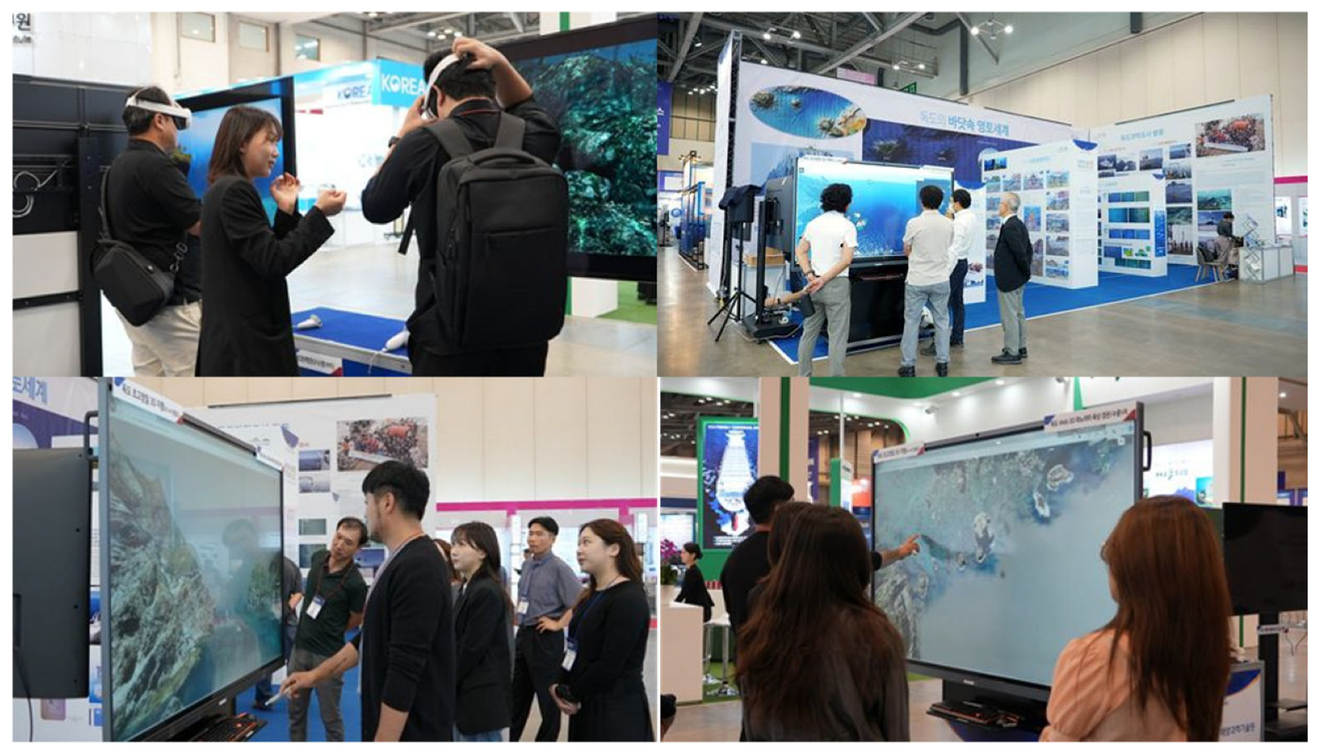
The Offshore Korea 2024 International Offshore Plant Technology Conference, held from 16–17 October 2024, at BEXCO, Busan, served as a global exhibition platform to share the latest technological trends in the offshore energy and plant industries, and to explore new business collaboration opportunities. As part of this event, the research team organized a special exhibition on Dokdo, as shown in Figure 18, showcasing immersive content that visualized the underwater and coastal landscapes of Dokdo. Through this demonstration, the project aimed to raise awareness of the ecological value of Dokdo and promote its sustainable preservation by engaging both the general public and experts.
The concept of the Dokdo special exhibition was designed to align with the scale and objectives of Offshore Korea 2024. The exhibition space was arranged to include a 360-degree aerial VR tour, underwater VR video content, and an interactive booth. Virtual Reality equipment (HMDs) allowed visitors to experience the marine and underwater environment of Dokdo in an immersive manner. Additionally, as illustrated in Figure 18, a large-scale screen was used to display the virtualized model of Dokdo, enabling a comprehensive visual exploration of the island’s terrain. Visitors could interact with the digital model by touching or clicking to rotate and zoom in on areas of interest. Furthermore, the Dokdo content developed in this study was mapped to geographic coordinates and linked to the large display, allowing viewers to access location-specific content. This configuration demonstrates the foundational integration of spatial data, immersive content, and interactive exploration, establishing an early-stage framework for future digital twin development, where geographic data, scientific simulations, and sensor-based research outputs will be integrated into a unified interactive system.
Since Offshore Korea 2024 is an international conference involving both the general public and marine industry professionals, the exhibition provided an important academic opportunity to validate the practical relevance, visual quality, and public engagement potential of the developed content. It also served to promote awareness of ocean conservation and the scientific significance of the Dokdo region.

4.2. User Evaluation of VR Content

Based on the field surveys described in Section 3.3, user satisfaction with the HMD-based VR healing content was evaluated for a total of 174 participants (n = 174), and the detailed distributions are summarized in Table 5. These surveys were conducted independently of the Offshore Korea exhibition and implemented in controlled indoor settings. The evaluation focused on four dimensions: overall satisfaction, willingness to re-engage, preferred content types, and qualitative assessments of the user experience.
  • High Willingness to Re-Engage
An overwhelming 97.1% of respondents expressed a willingness to re-experience the VR content, whereas only 2.9% indicated otherwise. This exceptionally high level of re-engagement intention demonstrates the strong potential of immersive VR content to sustain long-term participation and to serve as a repeatable and durable medium for environmental education and public outreach.
Preferences for future VR content also indicated clear user demand for embodied, realistic, and multisensory marine experiences. Specifically, 35.6% selected first-person marine experience content, 25.9% chose domestic/international marine landscape content, 21.8% preferred audio–visual integrated content, 16.1% selected interactive immersive content, and 0.6% selected “other” categories. These distributions offer concrete guidance for the next phase of VR content development, particularly in strengthening realistic imaging, first-person immersion, and enhanced sensory design.
  • Satisfaction Levels and Qualitative Feedback
Overall satisfaction was highly positive: 41.4% rated the content as “excellent,” 47.1% as “good,” 9.2% as “fair,” and 2.3% as “bad,” with no “poor” responses. Thus, 88.5% of users reported positive satisfaction (“excellent” or “good”), indicating broad acceptance of the VR experience in terms of visual quality, immersion, and interface usability.
Among those selecting “bad,” the primary reasons included unfamiliarity with VR headsets, temporary dizziness, and limited exposure to immersive environments. Additional open-ended responses identified specific areas requiring refinement, such as more diverse marine landscapes, higher-resolution underwater imaging, and enhanced ambient audio (e.g., wave sounds, underwater acoustic cues). These comments underscore the need for enhanced brightness calibration, color correction, and more immersive audio spatialization in future iterations.
  • Motivations for Re-Engagement
Participants frequently emphasized that the VR content provided novelty, emotional engagement, and psychological relaxation, extending beyond the mere delivery of information. Reported motivations such as “a new and interesting experience” and “stress-relief effects” suggest that immersive marine environments generate affective as well as educational benefits. These findings support the conclusion that VR-based ecological content can foster psychological comfort, experiential immersion, and emotional resonance, while also enhancing environmental understanding.
Collectively, the survey results confirm that the VR healing content exhibits strong usability, high satisfaction, and substantial re-engagement potential. The combination of quantitative responses and qualitative feedback provides a comprehensive understanding of user preferences, technical needs, and experiential outcomes, which will inform subsequent content optimization. Demographic characteristics and all response distributions are presented in Table 5. It is worth noting that the participant background information in the present evaluation was limited to basic demographic variables, such as sex and age. Due to the public, time-constrained nature of the on-site and field-based VR demonstrations, additional background variables, including education level, prior VR experience, and prior knowledge of Dokdo, were not collected. While this approach enabled broad public participation, future evaluations will incorporate more detailed participant background information to allow stratified analyses of usability and satisfaction outcomes.

4.3. Usability Assessment via the System Usability Scale (SUS)

To evaluate the usability and effectiveness of the immersive VR content and the Web3D-based digital twin visualization platform, a SUS assessment was conducted. The SUS is a widely applied, technology-independent tool consisting of 10 items rated on a five-point Likert scale, designed to quantify usability across diverse systems and sample sizes.
  • Evaluation Design and Participant Composition
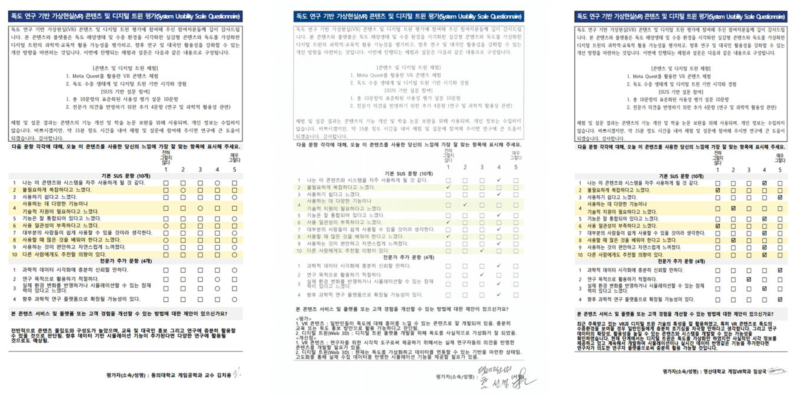
Originally, the SUS evaluation involved three domain experts. Additionally, a field-based SUS test was conducted with 42 participants at the 13th Annual Conference of the Korean Society of Coastal Disaster Prevention, targeting users who had experienced the HMD-based marine emotional-resource VR healing content. Participants experienced the VR content and completed the standard SUS questionnaire. This expanded dataset provides a more robust measure of usability, complementing the expert review with real-user feedback.
As in the original expert evaluation, the SUS questionnaire preserved the standard 10-item design. Four supplementary expert-oriented items were also included to assess (1) the reliability of scientific data visualization, (2) suitability for research purposes, (3) potential for simulation implementation, and (4) potential for expansion into a digital twin or scientific research platform, although these items were not used in SUS scoring.
  • SUS Score Calculation and Interpretation
SUS scores were calculated using the standard method: (response−1) for positively worded items and (5−response) for negatively worded items. The sum of the item contributions was multiplied by 2.5 to obtain a final score on the 0–100 scale. For the field-based evaluation (n = 42), summary statistics are presented in Table 6. The mean SUS score was 80.18, corresponding to an “excellent” usability rating according to Bangor et al. (2009) [43]. This indicates that the system is easy to use, imposes a low learning burden, and exhibits high user acceptance.
To examine usability characteristics beyond the aggregate SUS score, item-level descriptive statistics for each of the 10 SUS items were analyzed, as summarized in Table 7. The item-level SUS analysis indicates strong usability in terms of ease of use, learnability, and user confidence, as reflected by high mean scores for Items 3, 7, 9, and 10. Low scores for negatively worded items related to complexity and inconsistency (Items 2 and 6) further confirm that users did not perceive the system as difficult or unstable. However, moderate variability in Items 4 and 8 suggests that some users initially experienced uncertainty or interaction friction, which is consistent with qualitative feedback regarding media quality and the consistency of immersion. For contextual comparison, Table 8 summarizes SUS scores reported in recent studies on immersive virtual reality, digital health, and professional software.
Participants were also grouped according to prior marine healing experience (experienced vs. non-experienced). Mean SUS scores were comparable between the two groups, indicating that prior experience did not substantially influence perceived usability. This suggests that the platform is accessible to both novice users and those with prior domain exposure, with only a small difference in effect size and broadly similar usability perceptions across groups.
  • Reliability Analysis of the SUS Instrument
The internal consistency of the SUS responses was evaluated using Cronbach’s alpha (α). The resulting alpha value (α = 0.84) indicates good internal reliability, consistent with established validation studies of the SUS. Factor analysis (e.g., principal component analysis) was not performed because the SUS is a standardized unidimensional instrument, and the available sample size does not meet recommended thresholds for stable component extraction.
The three-expert evaluation yielded SUS scores of 90, 80, and 85, with an average of 85.0, also within the “good” to “excellent” range. These expert scores are reported in Table 9, and their distribution is illustrated in Figure 19. Taken together, both field-based and expert evaluations position the system within the high-usability (≥80) category, confirming that the platform is perceived as well-designed and straightforward to operate across both general and specialist user groups.
  • Summary of User Feedback and Expert Recommendations
Qualitative comments from the 42-participant evaluation highlighted several areas for improvement, most notably uneven underwater brightness due to depth-dependent light attenuation and environmental scattering, as well as limited ambient audio depth. These issues led users to suggest more vivid and consistent image quality, as well as richer sound design. Despite the high SUS scores, this feedback suggests that there is still room for improvement in media quality, particularly in terms of brightness, sharpness, and immersive sound.
In response, future production cycles will refine the quality management workflow by incorporating more systematic brightness and color correction, noise reduction, and audio balance optimization during post-processing. These upgrades are expected to enhance user immersion and presence, thereby maximizing the psychological and emotional benefits of the marine emotional-resource VR healing content.
Experts further recommended the integration of:
-
scientific analytical tools,
-
data-driven simulation modules,
-
research-focused interfaces, and
-
digital-twin expansion capabilities.
These enhancements will strengthen the platform’s scientific robustness and applicability across research, policy, and education.
  • Optimization Measures and Effectiveness Verification
Based on qualitative user feedback obtained during the SUS evaluation, two primary media-related issues were identified: uneven brightness in underwater scenes and insufficient depth in ambient audio. To address brightness inconsistency, post-processing workflows were refined to include depth-aware color correction, histogram-based brightness normalization, and scene-level exposure balancing during video stitching. These adjustments were applied to the finalized version of the VR content to minimize abrupt luminance transitions resulting from underwater light attenuation and scattering.
Audio-related limitations were addressed by enhancing spatial audio balance and ambient sound layering. Background marine soundscapes (e.g., wave motion and underwater ambient cues) were adjusted to improve immersion while avoiding auditory overload. Volume normalization and stereo balance correction were applied to ensure consistency across different scenes and playback devices.
The effectiveness of these optimization measures was verified through expert review and iterative content inspection during the final production stage. In particular, domain experts confirmed that the improved visual consistency and audio clarity were evident compared to earlier prototype versions. While no separate quantitative re-evaluation was conducted exclusively for the optimized version, the high SUS scores obtained in the field-based evaluation reflect overall user acceptance of the refined content. Future evaluations will incorporate controlled A/B testing and physiological response measurements to quantitatively assess the impact of media-level optimizations.
  • Scope of the Current Evaluation and Future Physiological Validation
It is essential to note that the present study focused on verifying system-level usability (encompassing usability and interface-level experience) rather than directly measuring the physiological efficacy of marine healing. Physiological responses—such as stress reduction or relaxation effects—were not quantitatively assessed in this phase. Future research will combine neurofeedback-based electroencephalography measurements with smartwatch-derived biosignals (e.g., heart rate and stress indices) to quantify pre- and post-changes associated with VR exposure. This will enable a more rigorous characterization of the psychological and physiological effects of marine emotional-resource VR healing content, providing empirical evidence for its role in the digital convergence of marine healing resources.
  • Overall Interpretation
The combined SUS evaluations demonstrate that the system exhibits excellent usability, strong accessibility, and high user acceptance across both expert and public contexts. This positions the platform as a practical, scalable, and scientifically meaningful tool for marine research communication, ecological education, and digital-twin development.

4.4. Environmental Sustainability Assessment

In this study, environmental sustainability assessment is approached from a digital and governance-oriented perspective rather than through direct biophysical impact metrics. The proposed immersive VR and digital twin platform contributes to environmental sustainability by reducing the need for repeated physical access to ecologically sensitive areas such as Dokdo, where direct human presence can cause disturbance to fragile coastal and marine ecosystems.
By enabling virtual access, remote visualization, and indirect experiential learning, the platform supports low-impact environmental awareness, education, and decision-making. In particular, the use of immersive VR content allows users to explore underwater and coastal environments without physical intrusion, thereby minimizing carbon emissions associated with transportation, vessel operation, and repeated field surveys.
From a long-term perspective, the digital twin framework provides a scalable foundation for sustainable environmental management by supporting data integration, continuous monitoring, and scenario-based analysis. Although real-time sensor data integration is not yet implemented, the system architecture is designed to incorporate future environmental indicators such as water temperature, wave conditions, and ecological observations, enabling adaptive and evidence-based sustainability assessment.
Therefore, the environmental sustainability of the proposed platform is reflected not in direct numerical impact scores but in its capacity to support conservation-oriented access, reduce environmental pressure, and facilitate sustainable governance of marine and island ecosystems.

5. Conclusions

This study developed an immersive VR content suite and a Web 3D-based digital virtualization platform to enhance the dissemination, interpretation, and practical use of scientific research on Dokdo Island, contributing directly to coastal climate resilience and marine conservation efforts. By integrating marine ICT convergence technologies with maritime and underwater spatial datasets, the project produced a geospatially accurate 3D model of Dokdo and a set of immersive scenarios that translate complex geophysical and ecological information into intuitive, experiential forms. These outputs establish a scalable foundation for a digital-twin framework capable of supporting education, public engagement, and data-driven environmental management.
The immersive VR content, constructed using high-resolution 360° video, underwater imagery, and scientifically validated research findings, enabled users to experience Dokdo’s coastal and submarine environment in realistic detail. Field-based evaluations, including a three-phase satisfaction survey (n = 174) and a SUS assessment (n = 42), demonstrated high satisfaction (88.5%), excellent usability (mean SUS score = 80.17), and strong willingness to re-engage (97.1%). These results reinforce earlier findings that immersive natural-environment VR enhances emotional engagement, reduces discomfort, and strengthens a sense of presence, underscoring the value of immersive media as a powerful tool for affective learning, fostering pro-environmental attitudes, and science communication.
The web 3D platform represents the initial phase of a Dokdo digital twin. Although real-time data integration is not yet implemented, the platform provides a robust structure for future incorporation of ecological sensor streams, scenario-based simulations, and environmental impact assessments. Such capabilities will support proactive climate-resilience planning, conservation strategies, and multidisciplinary science-policy dialogue. Linking this system with the national Dokdo Integrated Information System offers an additional pathway to expand public access to validated scientific data and strengthen evidence-based territorial and environmental decision-making.
Future advancements will focus on (1) real-time environmental data ingestion (e.g., water temperature, salinity, wave conditions), (2) expansion of VR content through additional species, high-resolution terrain, and hybrid rendering of virtual organisms, (3) broader usability assessments for both experts and general users, and (4) incorporation of physiological and neurofeedback measures, such as smartwatch-based biosignals and electroencephalography metrics, to evaluate cognitive and emotional responses to immersive marine environments. These enhancements will deepen the scientific rigor and interactive value of the system.
Overall, the framework presented here demonstrates the effectiveness of immersive marine ICT for visualizing research outputs, improving public understanding of coastal environmental change, and supporting sustainable, adaptive, evidence-based management of small island ecosystems. Continued algorithmic development, including machine-learning-based image analysis, ecological prediction models, and multi-sensor fusion, will enable the system to evolve from a primarily visualization-oriented platform into a comprehensive digital-twin tool for advanced scientific analysis, environmental forecasting, and policy-relevant, adaptive decision support.

Author Contributions

Conceptualization, M.H. and H.S.L.; methodology, M.H., H.S.L. and O.J.K.; investigation, M.H., H.S.L. and G.-S.J.; writing—original draft preparation, M.H. and H.S.L.; writing—review and editing, M.H., H.S.L., G.-S.J. and O.J.K.; supervision, H.S.L.; project administration, H.S.L. All authors have read and agreed to the published version of the manuscript.

Funding

This research was part of a project titled Efficacy/standardization technology development of marine healing resources and its lifecycle safety management, funded by the Ministry of Oceans and Fisheries, Korea (PM65200, KIMST grant no. 20220027). This research was a part of the project titled “Global Industry-Leading Research and Training Program for Innovative Human Resources in Marine Leisure Tourism (PM65110, RS-2025-02317535)”, funded by the Ministry of Oceans and Fisheries, Korea. This Research was supported by the project “Sustainable research and development of Dokdo (PG54801)” of the Ministry of Oceans and Fisheries, Korea. This research was funded by the Ministry of Trade, Industry, and Energy (MOTIE) of Korea under the “Regional Innovation Cluster Development Program (PN93140, P0025418)”, supervised by the Korea Institute for Advancement of Technology (KIAT).

Institutional Review Board Statement

This study, which focuses on the Immersive marine visualization, coastal resilience framework, digital twin foundation, did not require approval from an ethics committee or Institutional Review Board (IRB), as it was a low-risk, anonymous survey of adult participants. No personal, sensitive, or human subject data were collected.

Informed Consent Statement

Prior to participation, participants were verbally informed of the purpose of the study, the voluntary nature of participation, and data confidentiality, and only those who agreed proceeded with the questionnaire.

Data Availability Statement

The data presented in this study are available on request from the corresponding author. The data are not publicly available due to privacy and project-related restrictions.

Acknowledgments

During the preparation of this manuscript, the authors used ChatGPT (OpenAI, GPT-5.1) to assist with language editing and improving clarity and coherence of the text. All content was reviewed and revised by the authors, and the authors take full responsibility for the final version of the manuscript. The authors would also like to thank DMStudio for their technical support and collaboration throughout the project.

Conflicts of Interest

Author Oh Joon Kwon was employed by the company DMStudio. The remaining authors declare that the research was conducted in the absence of any commercial or financial relationships that could be construed as a potential conflict of interest.

References

  1. Song, S.J.; Park, J.; Ryu, J.; Rho, H.S.; Kim, W.; Khim, J.S. Biodiversity hotspot for marine invertebrates around the Dokdo, East Sea, Korea: Ecological checklist revisited. Mar. Pollut. Bull. 2017, 119, 162–170. [Google Scholar] [CrossRef] [Scilit]
  2. Bukh, A. Korean National Identity, Civic Activism and the Dokdo/Takeshima Territorial Dispute. J. Asian Secur. Int. Aff. 2016, 3, 183–199. [Google Scholar] [CrossRef] [Scilit]
  3. Choi, K.; Yoon, Y.-J.; Song, O.-Y.; Choi, S.-M. Interactive and immersive learning using 360 virtual reality contents on mobile platforms. Mob. Inf. Syst. 2018, 2018, 2306031. [Google Scholar] [CrossRef] [Scilit]
  4. Li, L.; Wu, S.; Xue, C.; Ma, Y.; Qin, Q. Research on Visualization Methods for Marine Environmental Element Fields in Twin Spaces. J. Mar. Sci. Eng. 2025, 13, 449. [Google Scholar] [CrossRef] [Scilit]
  5. Yin, Y.; Dong, Y.; Wang, K.; Wang, D.; Jones, B. Science as a Public Good: Public Use and Funding of Science; National Bureau of Economic Research: Cambridge, MA, USA, 2021. [Google Scholar]
  6. Abramo, G.; D’Angelo, A. The alignment of public research supply and industry demand for effective technology transfer: The case of Italy. Sci. Public Policy 2009, 36, 2–14. [Google Scholar] [CrossRef] [Scilit]
  7. Diaba-Nuhoho, P.; Amponsah-Offeh, M. Reproducibility and research integrity: The role of scientists and institutions. BMC Res. Notes 2021, 14, 451. [Google Scholar] [CrossRef] [Scilit] [PubMed]
  8. Klaeger, T.; Gottschall, S.; Oehm, L. Data science on industrial data—today’s challenges in brown field applications. Challenges 2021, 12, 2. [Google Scholar] [CrossRef] [Scilit]
  9. United Nations. Resolution Adopted by the General Assembly on 11 September 2015; United Nations: New York, NY, USA, 2015; Volume 14. [Google Scholar]
  10. Radianti, J.; Majchrzak, T.A.; Fromm, J.; Wohlgenannt, I. A systematic review of immersive virtual reality applications for higher education: Design elements, lessons learned, and research agenda. Comput. Educ. 2020, 147, 103778. [Google Scholar] [CrossRef] [Scilit]
  11. Coban, M.; Bolat, Y.I.; Goksu, I. The potential of immersive virtual reality to enhance learning: A meta-analysis. Educ. Res. Rev. 2022, 36, 100452. [Google Scholar] [CrossRef] [Scilit]
  12. McKinsey&Company. What Is Digital Twin Technology? 2023. Available online: https://www.mckinsey.com/featured-insights/mckinsey-explainers/what-is-digital-twin-technology (accessed on 29 October 2025).
  13. Hazeleger, W.; Aerts, J.; Bauer, P.; Bierkens, M.; Camps-Valls, G.; Dekker, M.; Doblas-Reyes, F.; Eyring, V.; Finkenauer, C.; Grundner, A. Digital twins of the Earth with and for humans. Commun. Earth Environ. 2024, 5, 463. [Google Scholar] [CrossRef] [Scilit]
  14. Riaz, K.; McAfee, M.; Gharbia, S.S. Management of climate resilience: Exploring the potential of digital twin technology, 3D city modelling, and early warning systems. Sensors 2023, 23, 2659. [Google Scholar] [CrossRef] [Scilit] [PubMed]
  15. Hoffmann, J.; Bauer, P.; Sandu, I.; Wedi, N.; Geenen, T.; Thiemert, D. Destination Earth—A digital twin in support of climate services. Clim. Serv. 2023, 30, 100394. [Google Scholar] [CrossRef] [Scilit]
  16. Bekele, M.K.; Pierdicca, R.; Frontoni, E.; Malinverni, E.S.; James, G. A survey of augmented, virtual, and mixed reality for cultural heritage. ACM J. Comput. Cult. Herit. 2018, 11, 36. [Google Scholar] [CrossRef] [Scilit]
  17. Biljecki, F.; Stoter, J.; Ledoux, H.; Zlatanova, S.; Çöltekin, A. Applications of 3D city models: State of the art review. ISPRS Int. J. Geo-Inf. 2015, 4, 2842–2889. [Google Scholar] [CrossRef] [Scilit]
  18. Korea.net. Dokdo Ecological Survey Reveals 594 New Species. 2016. Available online: https://www.korea.net/NewsFocus/Sci-Tech/view?articleId=141017 (accessed on 29 October 2025).
  19. Kim, J.C.; Yoo, K.D. Spatial and temporal distribution of macrobenthos in intertidal hard bottoms in Dokdo Island. Korean J. Environ. Ecol. 2015, 29, 221–227. [Google Scholar] [CrossRef] [Scilit]
  20. Cho, J.-S.R.; Kim, Y.-M.; Sagong, J.; Lee, J.-H.; Yeo, M.-Y.; Bahn, S.-Y.; Kim, H.-M.; Lee, G.-S.; Lee, D.-H.; Choo, Y.-S. Biodiversity of marine invertebrates on rocky shores of Dokdo, Korea. Zool. Stud. 2012, 51, 710–726. [Google Scholar]
  21. Myoung, J.-G. The fish fauna around Dokdo in the East Sea, Korea. Ocean Polar Res. 2002, 24, 449–455. [Google Scholar] [CrossRef] [Scilit]
  22. Prado, E.; Rodríguez-Basalo, A.; Cobo, A.; Ríos, P.; Sánchez, F. 3D fine-scale terrain variables from underwater photogrammetry: A new approach to benthic microhabitat modeling in a circalittoral Rocky shelf. Remote Sens. 2020, 12, 2466. [Google Scholar] [CrossRef] [Scilit]
  23. Cao, C.; Chen, J.; Feng, M.; Xu, C.; Zhang, P.; Zhou, P. Deep-sea submarine terrain monitoring—A brand new way. In Proceedings of the OCEANS 2019-Marseille, Marseille, France, 17–20 June 2019; pp. 1–5. [Google Scholar]
  24. Kang, J.-H.; Kim, H.-J. Temporal changes in gravel beach morphology of Dokdo Island using aerial photos and ground-based LiDAR data. J. Geomorphol. Assoc. Korea 2021, 28, 45–57. [Google Scholar] [CrossRef] [Scilit]
  25. Kang, J.; Sung, H. The morphological classification and stability of hillslope in the Dokdo. J. Korean Geomorphol. Assoc. 2009, 16, 15–27. [Google Scholar]
  26. Bianconi, F.; Filippucci, M.; Cornacchini, F.; Meschini, M.; Mommi, C. Cultural heritage and virtual reality: Application for visualization of historical 3D reproduction. Int. Arch. Photogramm. Remote Sens. Spat. Inf. Sci. 2023, 48, 203–210. [Google Scholar]
  27. Stylianidis, E.; Evangelidis, K.; Vital, R.; Dafiotis, P.; Sylaiou, S. 3D Documentation and visualization of cultural heritage buildings through the application of geospatial technologies. Heritage 2022, 5, 2818–2832. [Google Scholar] [CrossRef] [Scilit]
  28. Tao, F.; Qi, Q.; Liu, A.; Kusiak, A. Data-driven smart manufacturing. J. Manuf. Syst. 2018, 48, 157–169. [Google Scholar] [CrossRef] [Scilit]
  29. Yu, Z.; Du, P.; Yi, L.; Luo, W.; Li, D.; Zhao, B.; Li, L.; Zhang, Z.; Zhang, J.; Zhang, J.; et al. Coastal Zone Information Model: A comprehensive architecture for coastal digital twin by integrating data, models, and knowledge. Fundam. Res. 2024. [Google Scholar] [CrossRef] [Scilit]
  30. Jeddoub, I.; Nys, G.-A.; Hajji, R.; Billen, R. Digital Twins for cities: Analyzing the gap between concepts and current implementations with a specific focus on data integration. Int. J. Appl. Earth Obs. Geoinf. 2023, 122, 103440. [Google Scholar]
  31. Zhang, J.; Zhu, J.; Tu, W.; Wang, M.; Yang, Y.; Qian, F.; Xu, Y. The effectiveness of a digital twin learning system in assisting engineering education courses: A case of landscape architecture. Appl. Sci. 2024, 14, 6484. [Google Scholar] [CrossRef] [Scilit]
  32. Lim, H.S.; Hong, S.; Park, J.H.; Choi, Y.; Choi, H. Development of Coastal Disaster Simulation System using Marine Digital Twin Technology. J. Coast. Res. 2025, 113, 981–985. [Google Scholar] [CrossRef] [Scilit]
  33. Mullick, S.; Dutta, P.K.; Bhattacharya, P.; El-kenawy, E.-S.M. Digital twin technology for river basin management: A framework for proactive flood mitigation and water resource optimization. In Proceedings of the IET Conference Proceedings CP913, Hybrid Conference, Bahrain, 1–3 December 2024; pp. 660–665. [Google Scholar]
  34. Park, J.H.; Choi, Y.S.; Lim, H.S. Development of Ocean Healing VR Content Using Underwater Video Technology. J. Coast. Disaster Prev. 2024, 11, 71–77. [Google Scholar]
  35. Park, J.H.; Choi, Y.S.; Lim, H.S. Development of ICT-IoT-VR ocean healing platform using wearable device linkage application. In Proceedings of the International XR Conference, Busan, Republic of Korea, 20–22 May 2024; pp. 397–411. [Google Scholar]
  36. Walcutt, N.L.; Knörlein, B.; Sgouros, T.; Cetinić, I.; Omand, M.M. Virtual reality and oceanography: Overview, applications, and perspective. Front. Mar. Sci. 2019, 6, 644. [Google Scholar] [CrossRef] [Scilit]
  37. Meta. Using Virtual Reality to Connect with the Ocean. 2022. Available online: https://about.fb.com/news/2022/10/using-virtual-reality-to-connect-with-the-ocean/ (accessed on 29 October 2025).
  38. Dataparc. Understanding Digital Twin Platforms: Transforming Data into Actionable Insights. 2023. Available online: https://www.dataparc.com/blog/understanding-digital-twin-platforms-actionable-insights-2/ (accessed on 29 October 2025).
  39. Ge, C.; Qin, S. Urban flooding digital twin system framework. Syst. Sci. Control Eng. 2025, 13, 2460432. [Google Scholar] [CrossRef] [Scilit]
  40. Kerbl, B.; Kopanas, G.; Leimkühler, T.; Drettakis, G. 3D Gaussian splatting for real-time radiance field rendering. ACM Trans. Graph. 2023, 42, 1–14. [Google Scholar] [CrossRef] [Scilit]
  41. Lewis, J.R.; Sauro, J. Item benchmarks for the system usability scale. J. Usability Stud. 2018, 13, 158–167. [Google Scholar]
  42. Lewis, J.R.; Sauro, J. The factor structure of the system usability scale. In Human Centered Design, Proceedings of the First International Conference on Human Centered Design, San Diego, CA, USA, 19–24 July 2009; Springer: Berlin/Heidelberg, Germany, 2009; pp. 94–103. [Google Scholar]
  43. Bangor, A.; Kortum, P.; Miller, J. Determining what individual SUS scores mean: Adding an adjective rating scale. J. Usability Stud. 2009, 4, 114–123. [Google Scholar]
  44. Hyzy, M.; Bond, R.; Mulvenna, M.; Bai, L.; Dix, A.; Leigh, S.; Hunt, S. System usability scale benchmarking for digital health apps: Meta-analysis. JMIR Mhealth Uhealth 2022, 10, e37290. [Google Scholar] [CrossRef] [Scilit]
  45. Macris, A.; Drafta, S.; Martiniuc, Ș.; Petre, A.E. Comparative Usability Evaluation of Three Digital Smile Design Software Tools Using the System Usability Scale. Dent. J. 2025, 13, 418. [Google Scholar] [CrossRef] [Scilit]
  46. Lewis, J.R. The system usability scale: Past, present, and future. Int. J. Hum.–Comput. Interact. 2018, 34, 577–590. [Google Scholar] [CrossRef] [Scilit]
Figure 1. Location of the Dokdo Islands and the surrounding marine region in Northeast Asia. The zoom-in panel highlights the Dokdo study area, while the dashed outline indicates the spatial extent of datasets used for immersive virtual reality (VR) content development and digital twin–based visualization. Filming locations are indicated as follows: A, Keun-Gajae Rock; B, Jine Rock; C, Dongnipmun; and D, Hokdom Cave.
Sustainability 18 00593 g001
Figure 2. System architecture of the Web3D-based Dokdo digital twin and immersive VR platform. The layered structure illustrates user interaction, visualization, and real-time processing, as well as data integration interfaces (including future sensor ingestion) and data storage components that support scalable digital twin extension.
Sustainability 18 00593 g002
Figure 3. Equipment configuration for underwater 360° VR data acquisition. The Insta360 X4 camera, equipped with a dedicated dive case and stabilization system, was used to ensure pressure resistance, image stability, and consistent visual quality during underwater filming for the development of immersive VR content.
Sustainability 18 00593 g003
Figure 4. Field Safety Measurements for Underwater Filming.
Sustainability 18 00593 g004
Figure 5. The workflow for processing underwater 360° VR image data, including stitching, stabilization, color correction, and brightness normalization, is performed to ensure visual consistency and suitability for immersive VR visualization.
Sustainability 18 00593 g005
Figure 6. Final Output of the Post-Processed 360-Degree VR Underwater Footage around Dokdo.
Sustainability 18 00593 g006
Figure 7. Selected fish species from the Dokdo marine ecosystem for 3D modeling.
Sustainability 18 00593 g007
Figure 8. High-polygon 3D models of representative marine species around Dokdo, highlighting detailed morphological features such as skin texture, scales, and fins.
Sustainability 18 00593 g008
Figure 9. Retopology results for optimization of marine species 3D models.
Sustainability 18 00593 g009
Figure 10. Results of UV Mapping and Texturing Applied to Marine Species Models.
Sustainability 18 00593 g010
Figure 11. Planned Aerial Survey and 3D Mapping Routes for the Virtualization of Dokdo.
Sustainability 18 00593 g011
Figure 12. Generation of a 3D shape model using approximate flight altitudes for smart 3D capture flight-path planning.
Sustainability 18 00593 g012
Figure 13. 3D smart-capture flight-path mapping.
Sustainability 18 00593 g013
Figure 14. Aerial image data of Dokdo acquired via RTK drone (Matrice 4E, Smart 3D Capture method).
Sustainability 18 00593 g014
Figure 15. Directional calibration to ensure consistent spatial orientation during 360-degree panoramic transitions.
Sustainability 18 00593 g015
Figure 16. Reference to traditional 3D shape model extraction methods.
Sustainability 18 00593 g016
Figure 17. Result of Web-Based 3D Virtualization of Dokdo Using 3DGS-based Novel View Synthesis.
Sustainability 18 00593 g017
Figure 18. Exhibition-Based Demonstration of Dokdo Research Results.
Sustainability 18 00593 g018
Figure 19. Distribution of SUS scores reported in Table 4, based on evaluations by three Korean domain experts, illustrating expert-based assessments of usability, consistency, and applicability of the VR and Web3D digital twin platform.
Sustainability 18 00593 g019
Table 1. Quantitative comparison table between selection techniques and comparison groups. In the table, the symbols represent the following: ◎: Excellent, ◯: Good, △: Fair.
CategorySelected TechnologyAlternativesScientific Usability (Accuracy/Fidelity)Public Accessibility (Availability/Ease of Use)Industrial Applicability (Use Cases/Sustainability)Notes
VR DeviceMeta Quest 2/3HTC Vive, Valve Index△ Moderate (some precision loss)◎ Excellent (wireless, affordable)◎ Excellent (widely used in exhibition, education)Wireless, multi-platform support
HTC Vive Pro◎ Excellent (high precision, full tracking)△ Low (requires PC, expensive)△ Limited (industrial field use only)Expensive, wired
Valve Index◯ Good (accurate tracking, 144 Hz)△ Low (difficult setup)△ Limited (mainly gaming)Research usage limited
3D Reconstruction/RenderingSmart 3D Capture + 3DGSNeRF, Photogrammetry◎ Excellent (GSD 0.075 m/pixel, real-time rendering)◯ 3D Reconstruction/Rendering◯ Smart 3D Capture + 3DGSOptimized for real-time immersive visualization
Real-Time Spatial RenderingWebGLUnity, Unreal Engine◯ Good (web-based 3D rendering)◎ Excellent (no installation, browser-based)△ Moderate (industrial use requires tuning)Lightweight 3D environment
Unity◎ Excellent (simulation + scientific use)△ Low (installation needed)◎ Excellent (broadly used in education/industry)Complex setup, heavier platform
Unreal Engine◎ Excellent (realism, high-resolution)△ Low (expertise needed, steep learning curve)◎ Excellent (architecture, VFX)May be overkill for simple applications
Table 2. Summary of underwater 360° VR footage captured around Dokdo, including filming locations, number of clips, and recording durations. Location labels (A–D) correspond to the sites shown in Figure 1.
Filming LocationNumber of ClipsMinimum Duration (s)Maximum Duration (s)
Keun-Gajae Rock (A)1678187
Jine Rock (B)1411210
Dongnipmun (C)1319113
Hokdom Cave (D)743269
Table 3. Study design and participant flow for evaluating VR healing content.
PhasePeriodParticipantsEvent
13–6 May 2024902024 Wando Jangbogo Seafood Festival
27–10 May 202542Marine Leisure Tourism Expo
328–29 August 202542The 13th Annual Conference of the Korean Society of Coastal Disaster Prevention
Table 4. The SUS questionnaire was used to assess the usability of the marine healing VR content.
System Usability Scale Questionnaire
Thank you for participating in this usability evaluation of the marine healing virtual reality (VR) content developed as part of two research and development projects supported by the Ministry of Oceans and Fisheries of Korea and conducted by the Korea Institute of Ocean Science and Technology (KIOST): Efficacy and Standardization Technology Development of Marine Healing Resources and Their Life-Cycle Safety Management and the Global Industry-Leading Research and Training Program for Innovative Human Resources in Marine Leisure Tourism. This questionnaire is designed to assess the usability of the VR content you experienced. Your responses will be used exclusively for research purposes related to evaluating the effectiveness of the content. All information will remain confidential and will not be used for any purposes unrelated to this study.
Please indicate the extent to which you agree with each of the following statements by selecting the box that best reflects your experience with the content.
Strongly Disagree Strongly Agree
12345
1I would be inclined to use this marine healing content on a regular basis.
2I found this content to be unnecessarily complex.
3I found the content to be easy to use.
4I believe I would require technical assistance to use this content.
5I found that the various functions of this content were well integrated.
6I felt that the content exhibited too much inconsistency.
7I believe that most users would learn to use this content very quickly.
8I found the content somewhat cumbersome to use at first.
9I felt confident while using this content.
10I would recommend this content to others.
Table 5. Summary of participant characteristics and response patterns for overall, experienced, and non-experienced participants for VR healing content (a: Participants with marine healing experience, b: Participants without marine healing experience).
CategoryOverall
(n = 174)
Experienced ᵃ
(n = 49)
Non-Experienced ᵇ
(n = 125)
Male51.7%59.2%48.8%
Female48.3%40.8%51.2%
Most Common Age Group30–39 (24.7%)30–39 (26.5%)30–39 (24.0%)
High Satisfaction
(Excellent/Good)
88.5%87.8%88.8%
Bad Rating2.3%6.1%0.8%
Willingness to
Re-Engage (Yes)
97.1%100%96%
Top Preferred Content1st-person experience (35.6%)34.7%36.0%
Table 6. Summary Statistics for SUS Scores (n = 42).
StatisticValue
Mean80.18
Standard Deviation12.04
Median80.00
25th Percentile (Q1)72.50
75th Percentile (Q3)86.88
Table 7. Item-level descriptive statistics for the System Usability Scale (SUS) evaluation (n = 42).
ItemStatementMeanStandard DeviationStatus
1I would use this system frequently4.070.87Strong
2The system is unnecessarily complex1.520.89Excellent
3The system is easy to use4.550.74Excellent
4I would need technical support2.571.23Fair
5Functions are well integrated4.100.82Strong
6The system is inconsistent1.790.81Strong
7Most people would learn quickly4.550.77Excellent
8The system is cumbersome to use2.191.19Good
9I felt confident using the system4.310.68Strong
10I would recommend this system4.570.59Excellent
Table 8. Comparison of SUS scores reported in recent immersive VR and digital twin studies.
Platform TypeAvg. SUS ScoreSource/Context (Recent Research)
Digital health applications (physical activity apps only)83.28Meta-analysis of physical activity–focused digital health applications [44]
Dental software applications80.33Medit Link dental software usability study [45]
This study platform80.18Marine VR and Web3D digital twin platform (n = 42), this study
High-popularity mobile applications77.70Usability study of 15 widely used mobile apps (e.g., Facebook, Amazon) [46]
Digital health applications (all categories)76.64Comprehensive meta-analysis of digital health applications [44]
Dental software applications74.72PreTeeth AI Pro usability evaluation [45]
Dental software applications74.72SmileCloud software usability evaluation [45]
Digital health applications (excluding physical activity apps)68.05 Meta-analysis excluding physical activity–focused apps [44]
Global Industry Benchmark68.00Sauro–Lewis Curved Grading Scale (CGS) benchmark for acceptable usability [46]
Table 9. SUS Scores for the Developed VR and Web3D Digital Twin Platform.
ExpertSUS Score
Expert A90
Expert B80
Expert C85
Average85
Disclaimer/Publisher’s Note: The statements, opinions and data contained in all publications are solely those of the individual author(s) and contributor(s) and not of MDPI and/or the editor(s). MDPI and/or the editor(s) disclaim responsibility for any injury to people or property resulting from any ideas, methods, instructions or products referred to in the content.