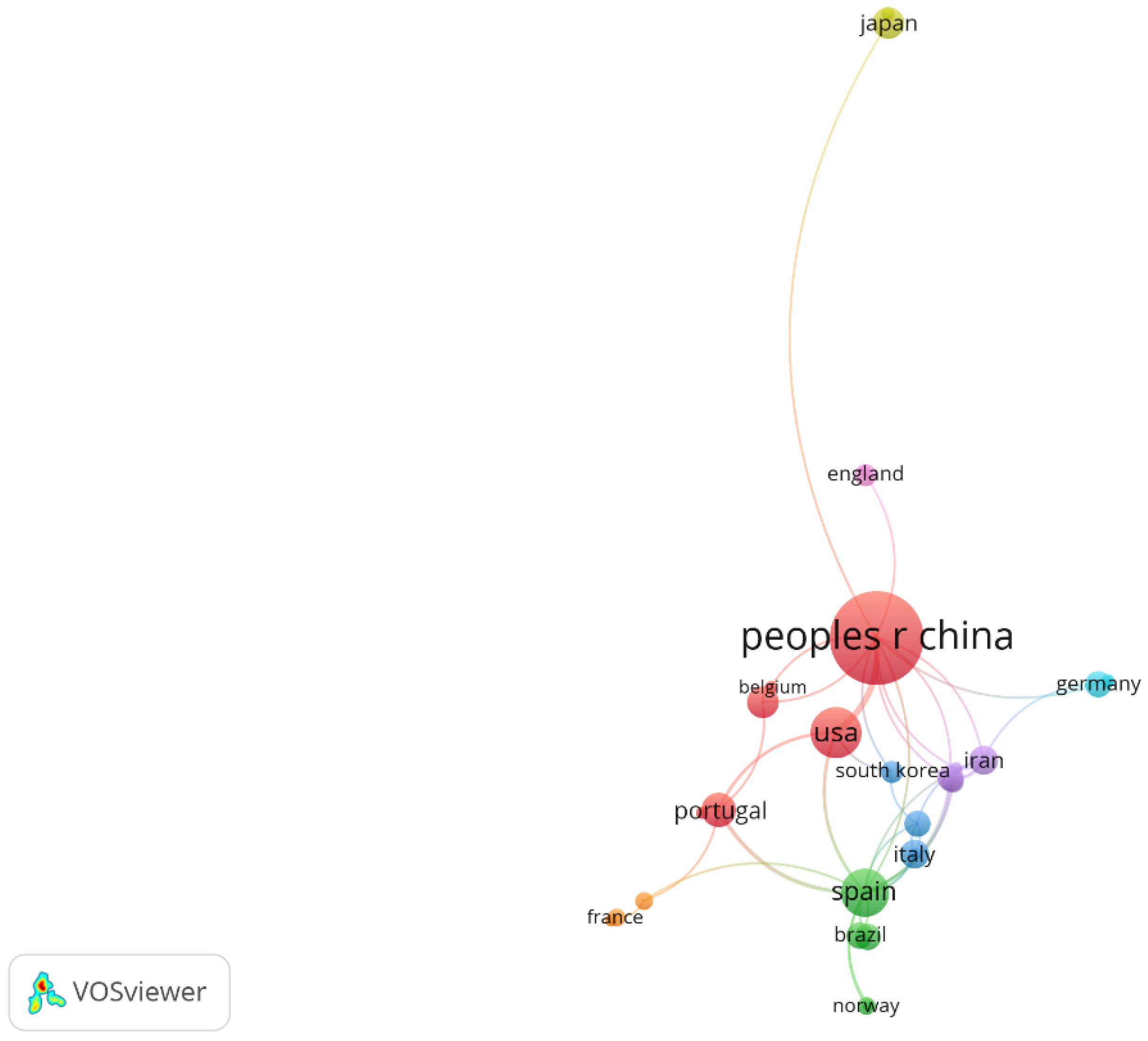
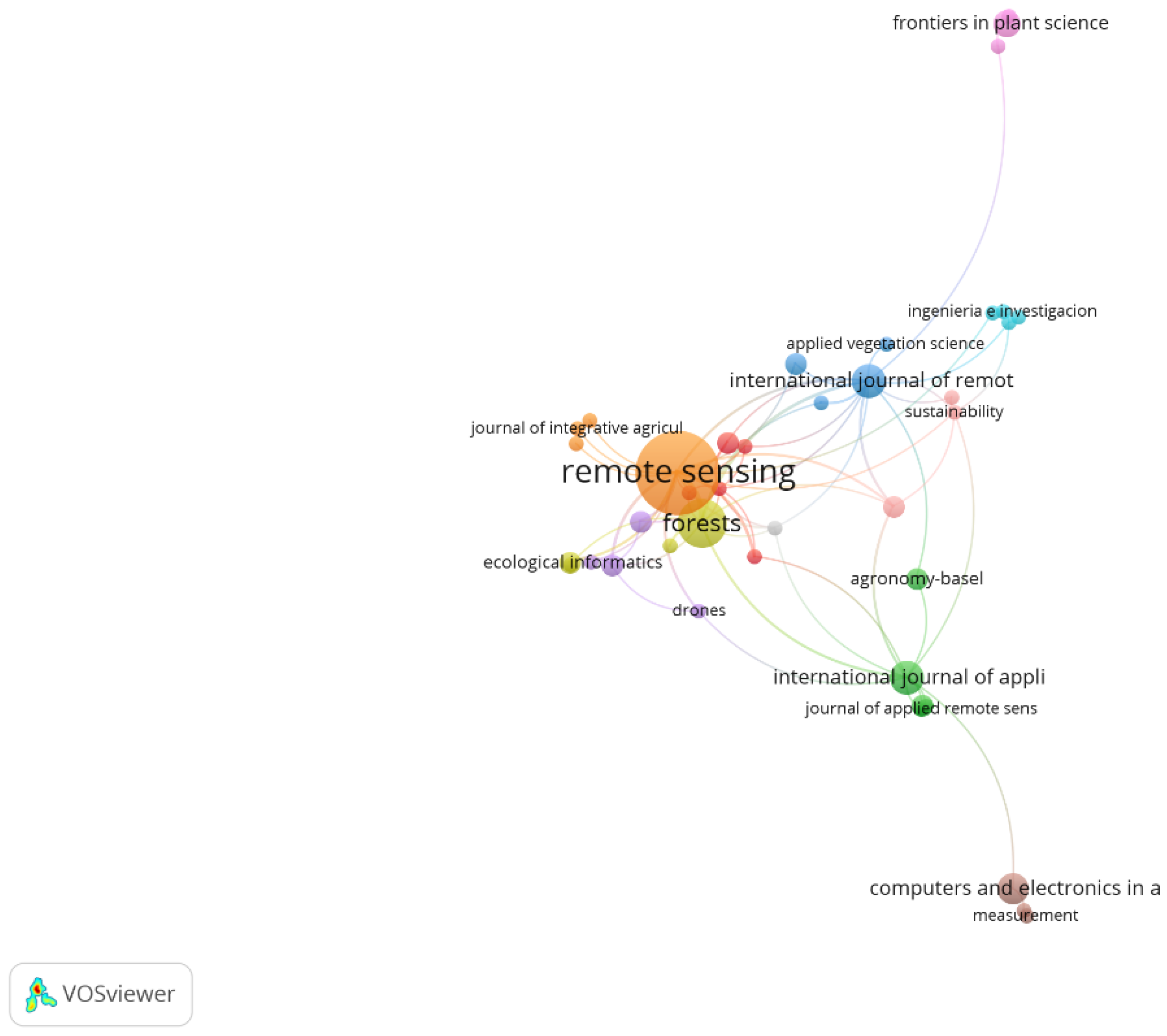
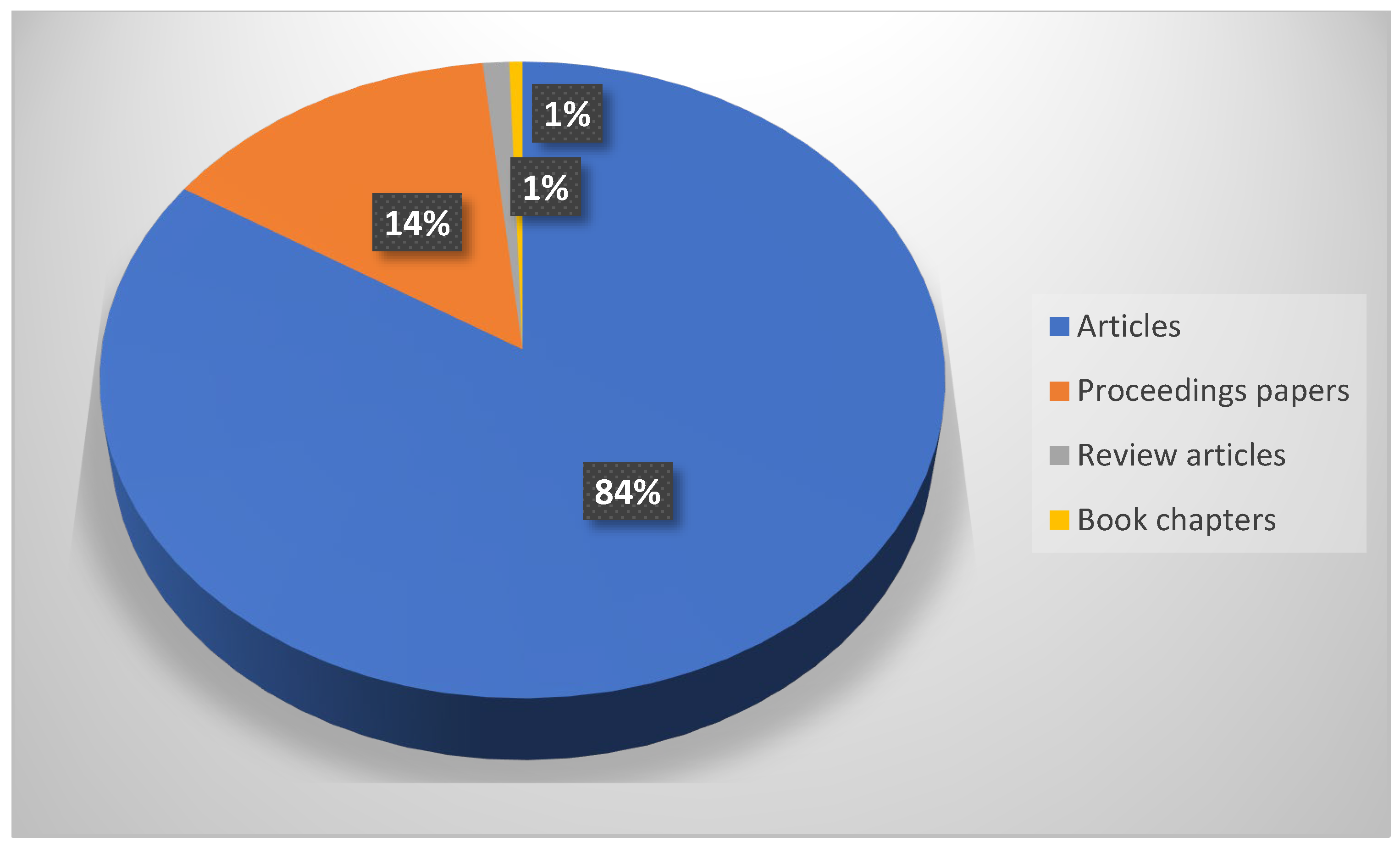
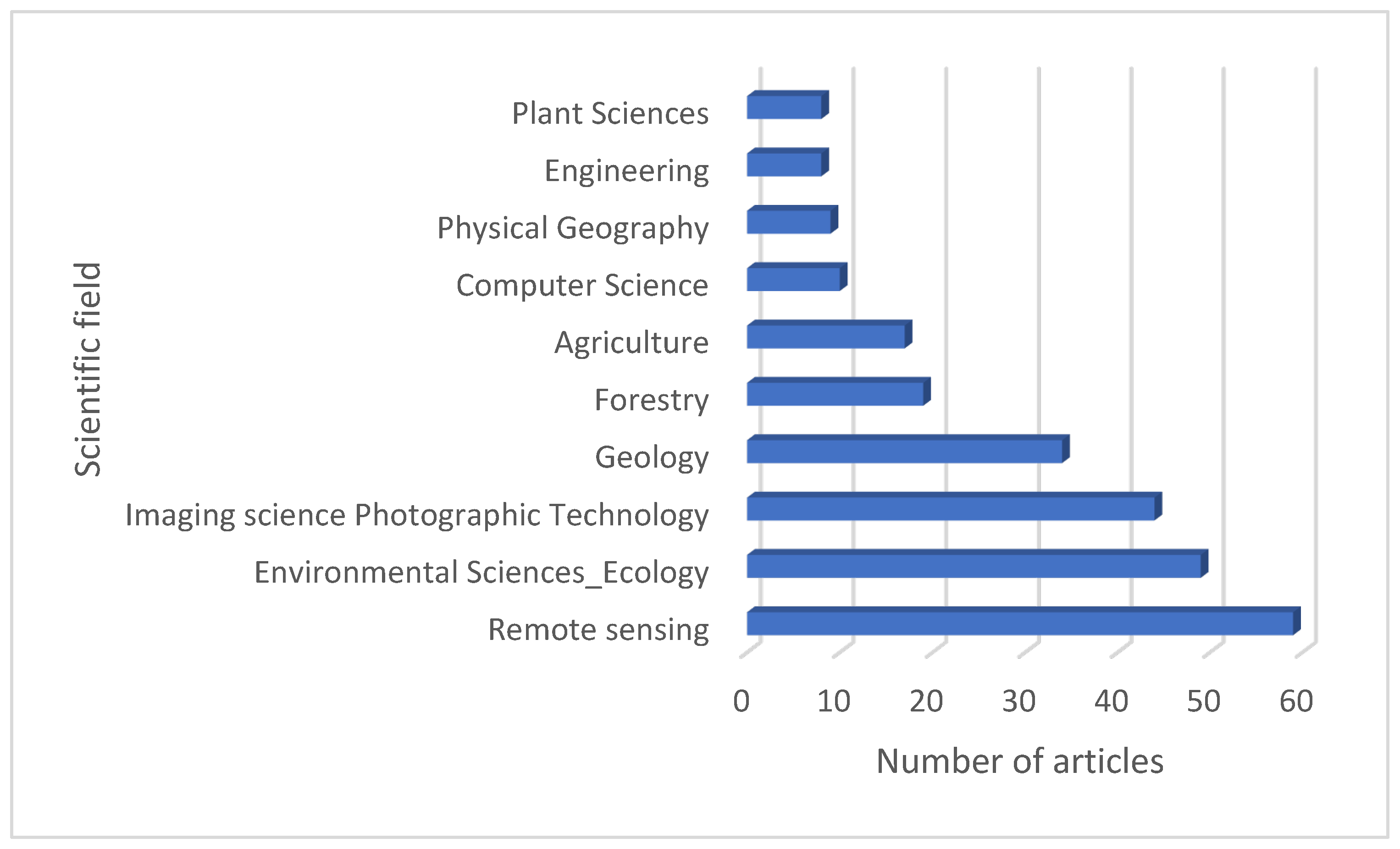
Sustainable Estimation of Tree Biomass and Volume Using UAV Imagery: A Comprehensive Review




Abstract
1. Introduction
2. Materials and Methods
2.1. Study Design and Data Sources
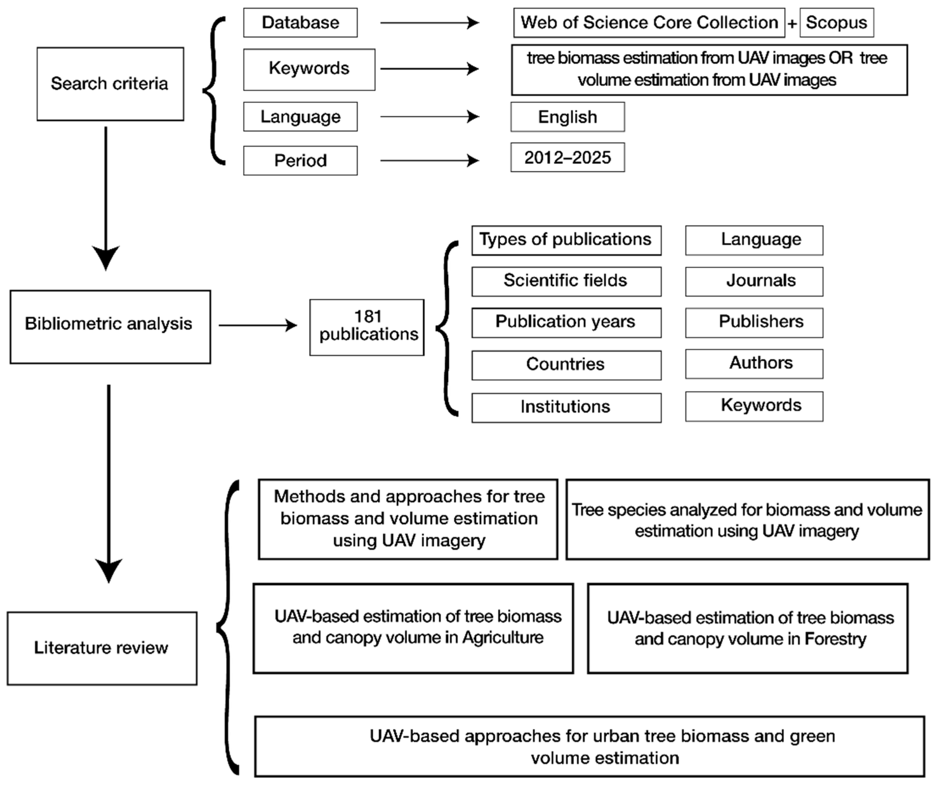
2.2. Search Strategy and Keyword Selection
2.3. Database Queries and Reproducibility
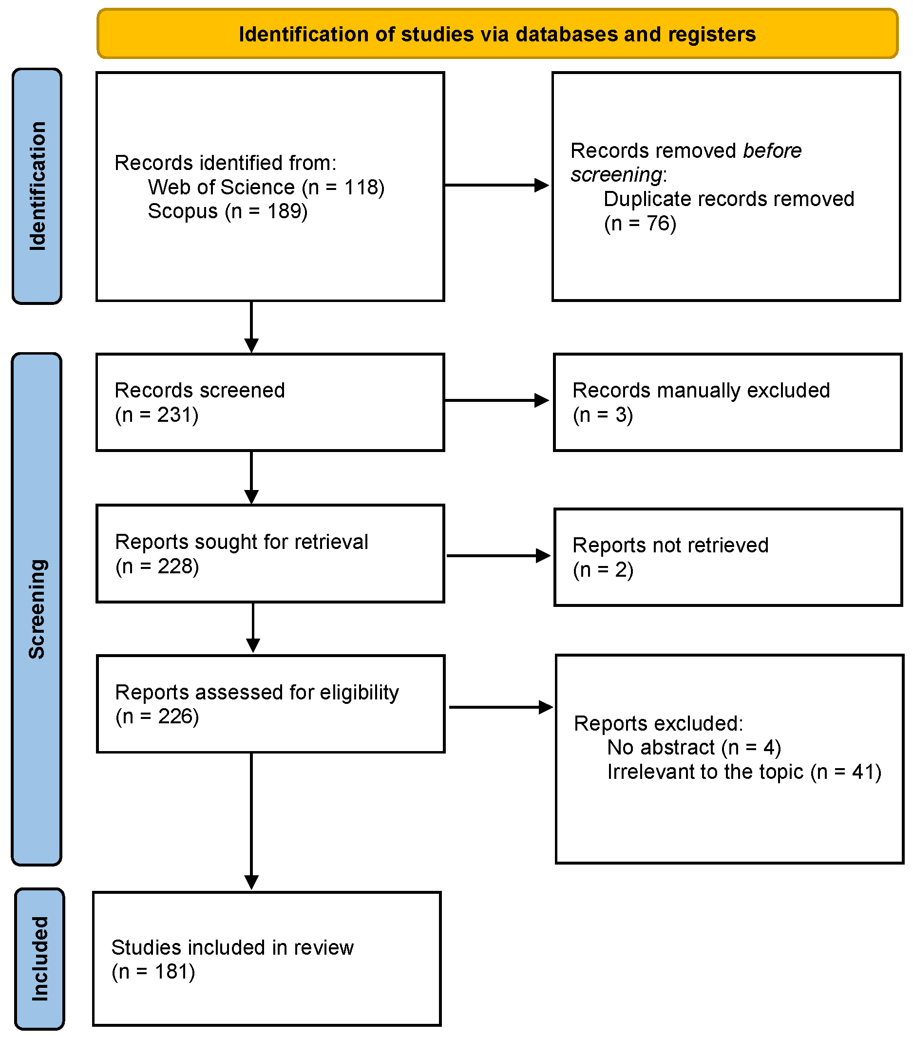
2.4. Screening Protocol
2.5. Search Parameters
2.6. De-Duplication and Data Quality Assurance
2.7. Inclusion and Exclusion Criteria
2.8. Screening and Reviewer Agreement
2.9. Final Dataset and Bibliometric Analysis
2.10. Qualitative Content Analysis
3. Results
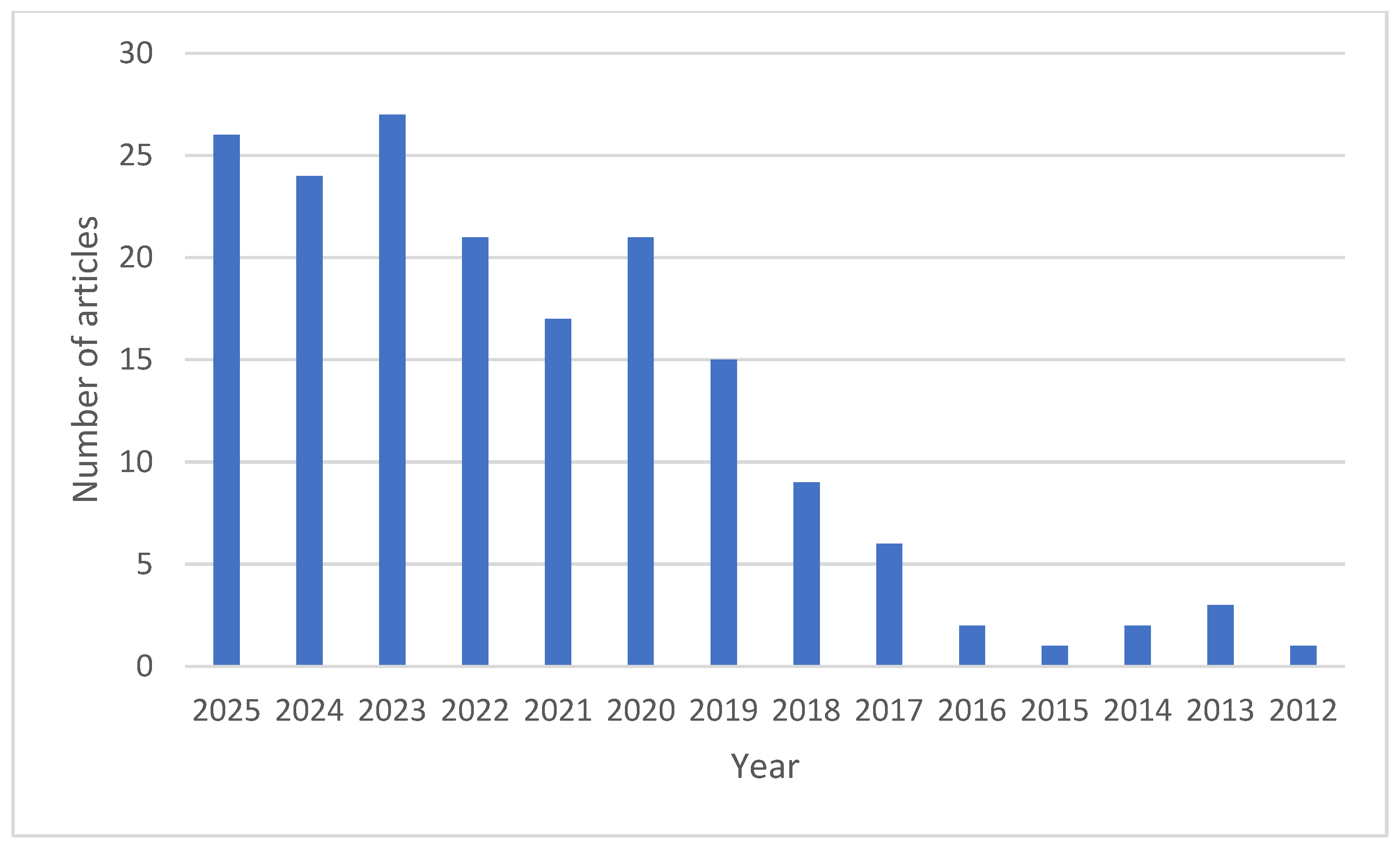
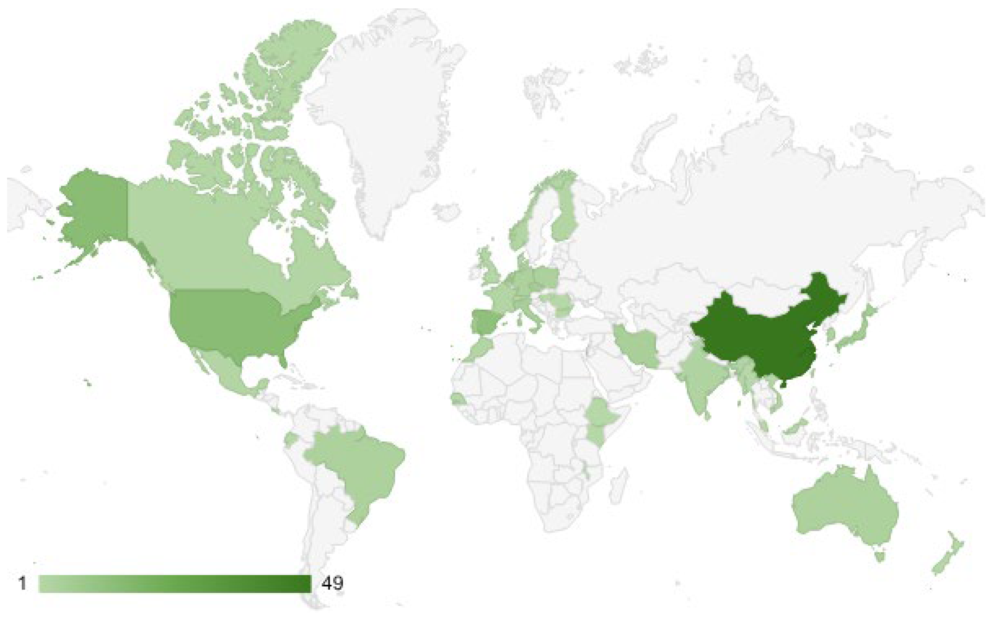
3.1. A Bibliometric Review
3.2. Literature Review
3.2.1. Methods and Approaches for Tree Biomass and Volume Estimation Using UAV Imagery
3.2.2. Tree Species Analyzed for Biomass and Volume Estimation Using UAV Imagery
3.2.3. UAV-Based Estimation of Tree Biomass and Canopy Volume in Agriculture
3.2.4. UAV-Based Estimation of Tree Biomass and Canopy Volume in Forestry
Pine Forests
Other Resinous Species Forests
Oak Forests
Other Broadleaved Tree Species
Mixed Forests
Mangrove Forests
Riparian and Afromontane Forests
3.2.5. UAV-Based Approaches for Urban Tree Biomass and Green Volume Estimation
4. Discussion
4.1. Bibliometric Review
4.2. Methodological Progress and Emerging Paradigms in UAV-Based Tree Biomass and Volume Estimation
4.2.1. Horizontal Methodological Comparison and Operational Implications
SfM Photogrammetry Versus UAV-LiDAR
Traditional Regression Versus Machine Learning Approaches
Applicability Across Spatial Scales
4.2.2. Practical Operational Guidance and Implementation Templates
4.3. Tree Species Representation in UAV-Based Biomass and Volume Studies
4.4. UAV-Based Estimation of Tree Biomass and Canopy Volume in Agricultural Systems
4.5. Advances and Challenges in UAV-Based Estimation of Forest Biomass and Structure
4.6. Opportunities and Challenges of UAV-Based Biomass and Volume Estimation in Urban and Sub-Urban Forests
4.7. Research Gaps and Future Directions
5. Conclusions
- Methodological standardization: There is a critical need for harmonized protocols covering UAV data acquisition, processing, and modeling to improve reproducibility and comparability across studies and regions.
- Uncertainty-aware modeling: Future studies should systematically quantify uncertainty and error propagation from individual-tree detection through biomass estimation, particularly for applications in carbon accounting and policy reporting.
- Scalability and integration: Bridging the gap between local UAV surveys and regional or national biomass assessments requires tighter integration with satellite imagery, airborne LiDAR, and forest inventory data.
- Ecosystem representativeness: Complex, biodiversity-rich forests—such as mixed broadleaved and tropical systems—remain underrepresented and should become a focal point of future UAV-based biomass research.
Author Contributions
Funding
Institutional Review Board Statement
Informed Consent Statement
Data Availability Statement
Conflicts of Interest
References
- Järnstedt, J.; Pekkarinen, A.; Tuominen, S.; Ginzler, C.; Holopainen, M.; Viitala, R. Forest variable estimation using a high-resolution digital surface model. ISPRS J. Photogramm. Remote Sens. 2012, 74, 78–84. [Google Scholar] [CrossRef] [Scilit]
- Straub, C.; Stepper, C.; Seitz, R.; Waser, L.T. Potential of UltraCamX stereo images for estimating timber volume and basal area at the plot level in mixed European forests. Can. J. For. Res. 2013, 43, 731–741. [Google Scholar] [CrossRef] [Scilit]
- White, J.C.; Wulder, M.A.; Vastaranta, M.; Coops, N.C.; Pitt, D.; Woods, M. The utility of image-based point clouds for forest inventory: A comparison with airborne laser scanning. Forests 2013, 4, 518–536. [Google Scholar] [CrossRef] [Scilit]
- Stepper, C.; Straub, C.; Pretzsch, H. Using semi-global matching point clouds to estimate growing stock at the plot and stand levels: Application for a broadleaf-dominated forest in central Europe. Can. J. For. Res. 2014, 45, 111–123. [Google Scholar] [CrossRef] [Scilit]
- Carleer, A.P.; Debeir, O.; Wolff, E. Assessment of Very High Spatial Resolution Satellite Image Segmentations. Photogramm. Eng. Remote Sens. 2005, 71, 1285–1294. [Google Scholar] [CrossRef] [Scilit]
- Murariu, G.; Dincă, L.; Munteanu, D. Trends and applications of principal component analysis in forestry research: A literature and bibliometric review. Forests 2025, 16, 1155. [Google Scholar] [CrossRef] [Scilit]
- Edson, C.; Wing, M.G. Airborne Light Detection and Ranging (LiDAR) for Individual Tree Stem Location, Height, and Biomass Measurements. Remote Sens. 2011, 3, 2494–2528. [Google Scholar] [CrossRef] [Scilit]
- Popescu, S.C.; Wynne, R.H.; Nelson, R.F. Measuring Individual Tree Crown Diameter with Lidar and Assessing Its Influence on Estimating Forest Volume and Biomass. Can. J. For. Res. 2003, 29, 564–577. [Google Scholar] [CrossRef] [Scilit]
- Tomppo, E.; Olsson, H.; Ståhl, G.; Nilsson, M.; Hagner, O.; Katila, M. Combining national forest inventory field plots and remote sensing data for forest databases. Remote Sens. Environ. 2008, 112, 1982–1999. [Google Scholar] [CrossRef] [Scilit]
- McRoberts, R.E.; Cohen, W.B.; Næsset, E.; Stehman, S.V.; Tomppo, E.O. Using remotely sensed data to construct and assess forest attribute maps and related spatial products. Scand. J. For. Res. 2010, 25, 340–367. [Google Scholar] [CrossRef] [Scilit]
- Murariu, G.; Stanciu, S.; Dincă, L.; Munteanu, D. GIS applications in monitoring and managing heavy metal contamination of water resources. Appl. Sci. 2025, 15, 10332. [Google Scholar] [CrossRef] [Scilit]
- White, J.C.; Coops, N.C.; Wulder, M.A.; Vastaranta, M.; Hilker, T.; Tompalski, P. Remote sensing technologies for enhancing forest inventories: A review. Can. J. Remote Sens. 2016, 42, 619–641. [Google Scholar] [CrossRef] [Scilit]
- Iizuka, K.; Yonehara, T.; Itoh, M.; Kosugi, Y. Estimating Tree Height and Diameter at Breast Height (DBH) from Digital Surface Models and Orthophotos Obtained with an Unmanned Aerial System for a Japanese Cypress (Chamaecyparis obtusa). Remote Sens. 2018, 10, 13. [Google Scholar] [CrossRef] [Scilit]
- Shin, P.; Sankey, T.; Moore, M.M.; Thode, A.E. Evaluating Unmanned Aerial Vehicle Images for Estimating Forest Canopy Fuels in a Ponderosa Pine Stand. Remote Sens. 2018, 10, 1266. [Google Scholar] [CrossRef] [Scilit]
- Dincă, L.; Coca, A.; Tudose, N.C.; Marin, M.; Murariu, G.; Munteanu, D. The role of trees in sand dune rehabilitation: Insights from global experiences. Appl. Sci. 2025, 15, 7358. [Google Scholar] [CrossRef] [Scilit]
- Slepetiene, A.; Belova, O.; Fastovetska, K.; Dincă, L.; Murariu, G. Advances in Understanding Carbon Storage and Stabilization in Temperate Agricultural Soils. Agriculture 2025, 15, 103390. [Google Scholar] [CrossRef] [Scilit]
- Pütz, S.; Groeneveld, J.; Henle, K.; Camargo Martensen, A.; Metz, M.; Metzger, J.P.; Ribeiro, M.C.; Dantas de Paula, M.; Huth, A. Long-term carbon loss in fragmented Neotropical forests. Nat. Commun. 2014, 5, 5037. [Google Scholar] [CrossRef] [Scilit]
- Ota, T.; Kajisa, T.; Mizoue, N.; Yoshida, S.; Takao, G.; Hirata, Y.; Furuya, N.; Sano, T.; Ponce-Hernandez, R.; Ahmed, O.S.; et al. Estimating aboveground carbon using airborne LiDAR in Cambodian tropical seasonal forests for REDD+ implementation. J. For. Res. 2015, 20, 484–492. [Google Scholar] [CrossRef] [Scilit]
- Mitchell, A.L.; Rosenqvist, A.; Mora, B. Current remote sensing approaches to monitoring forest degradation in support of countries’ measurement, reporting and verification (MRV) systems for REDD+. Carbon Balance Manag. 2017, 12, 9. [Google Scholar] [CrossRef] [Scilit]
- Mihalache, A.L.; Marin, M.; Davidescu, Ș.O.; Ungurean, C.; Adorjani, A.; Tudose, N.C.; Davidescu, A.A.; Clinciu, I. Physical status of torrent control structures in Romania. Environ. Eng. Manag. J. 2020, 19, 861–872. [Google Scholar] [CrossRef] [Scilit]
- Marin, M.; Clinciu, I.; Tudose, N.C.; Ungurean, C.; Mihalache, A.L.; Mărțoiu, N.E.; Tudose, O.N. Assessment of seasonal surface runoff under climate and land use change scenarios for a small forested watershed: Upper Tărlung Watershed (Romania). Water 2022, 14, 2860. [Google Scholar] [CrossRef] [Scilit]
- Marin, M.; Tudose, N.C.; Ungurean, C.; Mihalache, A.L. Application of life cycle assessment for torrent control structures: A review. Land 2024, 13, 1956. [Google Scholar] [CrossRef] [Scilit]
- Tudose, N.C.; Cheval, S.; Ungurean, C.; Broekman, A.; Sanchez-Plaza, A.; Cremades, R.; Pereira, P. Climate services for sustainable resource management: The water–energy–land nexus in the Tărlung River Basin (Romania). Land Use Policy 2022, 119, 106221. [Google Scholar] [CrossRef] [Scilit]
- Dincă, L.; Murariu, G.; Lupoae, M. Understanding the ecosystem services of riparian forests: Patterns, gaps, and global trends. Forests 2025, 16, 947. [Google Scholar] [CrossRef] [Scilit]
- Thenkabail, P.S.; Durrieu, S.; Véga, C.; Bouvier, M.; Gosselin, F.; Renaud, J.-P.; Saint-André, L. Optical remote sensing of tree and stand heights. In Land Resources Monitoring, Modeling, and Mapping with Remote Sensing; CRC Press: Boca Raton, FL, USA, 2015; pp. 449–485. [Google Scholar]
- Sibona, E.; Vitali, A.; Meloni, F.; Caffo, L.; Dotta, A.; Lingua, E.; Motta, R.; Garbarino, M. Direct measurement of tree height provides different results on the assessment of LiDAR accuracy. Forests 2016, 8, 7. [Google Scholar] [CrossRef] [Scilit]
- Díaz-Varela, R.A.; de la Rosa, R.; León, L.; Zarco-Tejada, P.J. High-resolution airborne UAV imagery to assess olive tree crown parameters using 3D photo reconstruction: Application in breeding trials. Remote Sens. 2015, 7, 4213–4232. [Google Scholar] [CrossRef] [Scilit]
- Williams, M.S.; Bechtold, W.A.; LaBau, V.J. Five instruments for measuring tree height: An evaluation. South. J. Appl. For. 1994, 18, 76–82. [Google Scholar] [CrossRef] [Scilit]
- Panagiotidis, D.; Abdollahnejad, A.; Surový, P.; Chiteculo, V. Determining tree height and crown diameter from high-resolution UAV imagery. Int. J. Remote Sens. 2016, 38, 2392–2410. [Google Scholar] [CrossRef] [Scilit]
- Baltsavias, E.P. A comparison between photogrammetry and laser scanning. ISPRS J. Photogramm. Remote Sens. 1999, 54, 83–94. [Google Scholar] [CrossRef] [Scilit]
- Næsset, E. Predicting forest stand characteristics with airborne scanning laser using a practical two-stage procedure and field data. Remote Sens. Environ. 2002, 80, 88–99. [Google Scholar] [CrossRef] [Scilit]
- St-Onge, B.; Vega, C.; Fournier, R.A.; Hu, Y. Mapping canopy height using a combination of digital stereo-photogrammetry and lidar. Int. J. Remote Sens. 2008, 29, 3343–3364. [Google Scholar] [CrossRef] [Scilit]
- Bohlin, J.; Wallerman, J.; Fransson, J.E. Forest variable estimation using photogrammetric matching of digital aerial images in combination with a high-resolution DEM. Scand. J. For. Res. 2012, 27, 692–699. [Google Scholar] [CrossRef] [Scilit]
- Lisein, J.; Pierrot-Deseilligny, M.; Bonnet, S.; Lejeune, P. A photogrammetric workflow for the creation of a forest canopy height model from small unmanned aerial system imagery. Forests 2013, 4, 922–944. [Google Scholar] [CrossRef] [Scilit]
- Wallace, L.; Lucieer, A.; Malenovský, Z.; Turner, D.; Vopěnka, P. Assessment of forest structure using two UAV techniques: A comparison of airborne laser scanning and structure from motion (SfM) point clouds. Forests 2016, 7, 62. [Google Scholar] [CrossRef] [Scilit]
- Peticilă, A.; Iliescu, P.G.; Dincă, L.; Popa, A.-S.; Murariu, G. Vegetation indices from UAV imagery: Emerging tools for precision agriculture and forest management. AgriEngineering 2025, 7, 431. [Google Scholar] [CrossRef] [Scilit]
- Puliti, S.; Ørka, H.O.; Gobakken, T.; Næsset, E. Inventory of small forest areas using an unmanned aerial system. Remote Sens. 2015, 7, 9632–9654. [Google Scholar] [CrossRef] [Scilit]
- Dandois, J.P.; Ellis, E.C. High spatial resolution three-dimensional mapping of vegetation spectral dynamics using computer vision. Remote Sens. Environ. 2013, 136, 259–276. [Google Scholar] [CrossRef] [Scilit]
- Tang, L.; Shao, G. Drone remote sensing for forestry research and practices. J. For. Res. 2015, 26, 791–797. [Google Scholar] [CrossRef] [Scilit]
- Baltsavias, E.; Gruen, A.; Eisenbeiss, H.; Zhang, L.; Waser, L.T. High-quality image matching and automated generation of 3D tree models. Int. J. Remote Sens. 2008, 29, 1243–1259. [Google Scholar] [CrossRef] [Scilit]
- Zarco-Tejada, P.J.; Diaz-Varela, R.; Angileri, V.; Loudjani, P. Tree height quantification using very high resolution imagery acquired from an Unmanned Aerial Vehicle (UAV) and automatic 3D photo-reconstruction methods. Eur. J. Agron. 2014, 55, 89–99. [Google Scholar] [CrossRef] [Scilit]
- Poley, L.G.; McDermid, G.J. A systematic review of the factors influencing the estimation of vegetation aboveground biomass using unmanned aerial systems. Remote Sens. 2020, 12, 1052. [Google Scholar] [CrossRef] [Scilit]
- Bouguettaya, A.; Zarzour, H.; Kechida, A.; Taberkit, A.M. Deep learning techniques to classify agricultural crops through UAV imagery: A review. Neural Comput. Appl. 2022, 34, 9511–9536. [Google Scholar] [CrossRef] [Scilit] [PubMed]
- Shahi, T.; Xu, C.; Neupane, A.; Guo, W. Machine learning methods for precision agriculture with UAV imagery: A review. Electron. Res. Arch. 2022, 30, era-30-12-218. [Google Scholar] [CrossRef] [Scilit]
- Jiang, S.; Jiang, C.; Jiang, W. Efficient structure from motion for large-scale UAV images: A review and a comparison of SfM tools. ISPRS J. Photogramm. Remote Sens. 2020, 167, 230–251. [Google Scholar] [CrossRef] [Scilit]
- Istiak, M.A.; Syeed, M.M.; Hossain, M.S.; Uddin, M.F.; Hasan, M.; Khan, R.H.; Azad, N.S. Adoption of Unmanned Aerial Vehicle (UAV) imagery in agricultural management: A systematic literature review. Ecol. Inform. 2023, 78, 102305. [Google Scholar] [CrossRef] [Scilit]
- Dincă, L.; Crișan, V.; Ienașoiu, G.; Murariu, G.; Drășovean, R. Environmental indicator plants in mountain forests: A review. Plants 2024, 13, 3358. [Google Scholar] [CrossRef] [Scilit]
- Tudor, C.; Constandache, C.; Dincă, L.; Murariu, G.; Badea, N.O.; Tudose, N.C.; Marin, M. Pine afforestation on degraded lands: A global review of carbon sequestration potential. Front. For. Glob. Change 2025, 8, 1648094. [Google Scholar] [CrossRef] [Scilit]
- Timiș-Gansac, V.; Dincă, L.; Tudose, N.C.; Constandache, C.; Murariu, G.; Cheregi, G.; Moțiu, P.T.; Derecichei, L.M. Community-based conservation in mountain forests: Patterns, challenges, and policy implications. Trees For. People 2025, 22, 101041. [Google Scholar] [CrossRef] [Scilit]
- Slepetiene, A.; Belova, O.; Fastovetska, K.; Dincă, L.; Murariu, G. Managing boreal birch forests for climate change mitigation. Land 2025, 14, 1909. [Google Scholar] [CrossRef] [Scilit]
- Page, M.J.; McKenzie, J.E.; Bossuyt, P.M.; Boutron, I.; Hoffmann, T.C.; Mulrow, C.D.; Shamseer, L.; Tetzlaff, J.M.; Akl, E.A.; Brennan, S.E.; et al. The PRISMA 2020 statement: An updated guideline for reporting systematic reviews. BMJ 2021, 372, n71. [Google Scholar] [CrossRef] [Scilit]
- Elsevier. Scopus. Available online: https://www.elsevier.com/products/scopus (accessed on 20 June 2025).
- Clarivate. Web of Science Core Collection. Available online: https://clarivate.com/academia-government/scientific-and-academic-research/research-discovery-and-referencing/web-of-science/web-of-science-core-collection/ (accessed on 20 June 2025).
- Microsoft Corporation. Microsoft Excel. Available online: https://www.microsoft.com/en/microsoft-365/excel?market=af (accessed on 26 June 2025).
- Google. GeoChart. Available online: https://developers.google.com/chart/interactive/docs/gallery/geochart (accessed on 23 June 2025).
- VOSviewer. Available online: https://www.vosviewer.com/ (accessed on 22 June 2025).
- Abdollahnejad, A.; Panagiotidis, D.; Surový, P. Estimation and extrapolation of tree parameters using spectral correlation between UAV and Pléiades data. Forests 2018, 9, 85. [Google Scholar] [CrossRef] [Scilit]
- Effiom, A.E.; van Leeuwen, L.M.; Nyktas, P.; Okojie, J.A.; Erdbrügger, J. Combining unmanned aerial vehicle and multispectral Pleiades data for tree species identification, a prerequisite for accurate carbon estimation. J. Appl. Remote Sens. 2019, 13, 034530. [Google Scholar] [CrossRef] [Scilit]
- Ni, W.; Sun, G.; Pang, Y.; Zhang, Z.; Liu, J.; Yang, A.; Zhang, D. Mapping three-dimensional structures of forest canopy using UAV stereo imagery: Evaluating impacts of forward overlaps and image resolutions with LiDAR data as reference. IEEE J. Sel. Top. Appl. Earth Obs. Remote Sens. 2018, 11, 3578–3589. [Google Scholar] [CrossRef] [Scilit]
- Chumbimune-Vivanco, S.Y.; León, H.; Llanos-Carrillo, C.; Millan-Ramírez, J.; Vilca-Gamarra, C.; Vera, E.; Cruz-Grimaldo, C. Integration of VANT-LiDAR with multispectral imagery for the estimation of carbon stocks in Prosopis sp. forest plantations. Sci. Agropecu. 2025, 16, 333. [Google Scholar] [CrossRef] [Scilit]
- González-Jaramillo, V.; Fries, A.; Bendix, J. AGB estimation in a tropical mountain forest (TMF) by means of RGB and multispectral images using an unmanned aerial vehicle (UAV). Remote Sens. 2019, 11, 1413. [Google Scholar] [CrossRef] [Scilit]
- Afsar, M.M.; Bakhshi, A.D.; Iqbal, M.S.; Hussain, E.; Iqbal, J. High-precision mango orchard mapping using a deep learning pipeline leveraging object detection and segmentation. Remote Sens. 2024, 16, 3207. [Google Scholar] [CrossRef] [Scilit]
- Dorbu, F.E.; Hashemi-Beni, L. Geospatial intelligence for individual crop detection and anomaly monitoring. In Proceedings of the IGARSS 2023—IEEE International Geoscience and Remote Sensing Symposium, Pasadena, CA, USA, 16–21 July 2023; IEEE: New York, NY, USA, 2023; pp. 1051–1054. [Google Scholar]
- Duan, M.; Sanchez-Azofeifa, A.; Abdulmajeed, M.; Turner, D.; Buckingham, K.; Odari, A.; Kasraee, N. Aboveground carbon estimation in a mangrove ecosystem using UAV-based remote sensing and machine learning. Ecol. Indic. 2025, 178, 113950. [Google Scholar] [CrossRef] [Scilit]
- Erfanifard, Y.; Hosingholizade, A.; Griess, V.C.; Millan, V.E.G.; Pirasteh, S. Estimating tree diameter at breast height (DBH) from UAV data: A comparison of oblique–vertical imagery fusion and allometric modeling. Sci. Remote Sens. 2025, 12, 100331. [Google Scholar] [CrossRef] [Scilit]
- Ghasemi, M.; Latifi, H.; Shafeian, E.; Naghavi, H.; Pourhashemi, M. A novel linear spectral unmixing-based method for tree decline monitoring by fusing UAV-RGB and optical space-borne data. Int. J. Remote Sens. 2024, 45, 1079–1109. [Google Scholar] [CrossRef] [Scilit]
- Han, L.; Wang, Z.; He, M.; He, X. Effects of different ground segmentation methods on the accuracy of UAV-based canopy volume measurements. Front. Plant Sci. 2024, 15, 1393592. [Google Scholar] [CrossRef] [Scilit]
- He, H.; Yan, Y.; Chen, T.; Cheng, P. Tree height estimation of forest plantation in mountainous terrain from bare-earth points using a DoG-coupled radial basis function neural network. Remote Sens. 2019, 11, 1271. [Google Scholar] [CrossRef] [Scilit]
- Hnida, Y.; Mahraz, M.A.; Riffi, J.; Achebour, A.; Yahyaouy, A.; Tairi, H. Transfer learning-enhanced deep learning for tree crown geometric analysis and crop yield estimation using UAV imagery. Remote Sens. Appl. Soc. Environ. 2025, 39, 101663. [Google Scholar] [CrossRef] [Scilit]
- Janiec, P.; Hawryło, P.; Tymińska-Czabańska, L.; Miszczyszyn, J.; Socha, J. A low-cost alternative to LiDAR for site index models: Applying repeated digital aerial photogrammetry data in the modelling of forest top height growth. Forestry 2024, cpae047. [Google Scholar] [CrossRef] [Scilit]
- Jarahizadeh, S.; Salehi, B. Tree-Net: A novel deep learning tree detection architecture using UAV LiDAR data. Remote Sens. Environ. 2026, 332, 115088. [Google Scholar] [CrossRef] [Scilit]
- Jayathunga, S.; Owari, T.; Tsuyuki, S. Digital aerial photogrammetry for uneven-aged forest management: Assessing the potential to reconstruct canopy structure and estimate living biomass. Remote Sens. 2019, 11, 338. [Google Scholar] [CrossRef] [Scilit]
- Kameyama, S.; Sugiura, K. Effects of differences in structure from motion software on image processing of unmanned aerial vehicle photography and estimation of crown area and tree height in forests. Remote Sens. 2021, 13, 626. [Google Scholar] [CrossRef] [Scilit]
- Lei, L.; Chai, G.; Wang, Y.; Jia, X.; Yin, T.; Zhang, X. Estimating individual tree above-ground biomass of Chinese fir plantation: Exploring the combination of multi-dimensional features from UAV oblique photos. Remote Sens. 2022, 14, 504. [Google Scholar] [CrossRef] [Scilit]
- Ma, Y.; Im, J.; Zhen, Z.; Zhao, Y. A framework for upscaling aboveground biomass from an individual tree to landscape level and qualifying the multiscale spatial uncertainties for secondary forests. Geo-Spat. Inf. Sci. 2025, 28, 97–116. [Google Scholar] [CrossRef] [Scilit]
- Mao, Z.; Lu, Z.; Wu, Y.; Deng, L. DBH estimation for individual tree: Two-dimensional images or three-dimensional point clouds? Remote Sens. 2023, 15, 4116. [Google Scholar] [CrossRef] [Scilit]
- Moreira, B.M.; Goyanes, G.; Pina, P.; Vassilev, O.; Heleno, S. Assessment of the influence of survey design and processing choices on the accuracy of tree diameter at breast height (DBH) measurements using UAV-based photogrammetry. Drones 2021, 5, 43. [Google Scholar] [CrossRef] [Scilit]
- He, Y.-Y.; Zhang, Y.-B.; Li, J.-Q.; Wang, J.-L. Estimation of stem biomass of individual Abies faxoniana through unmanned aerial vehicle remote sensing. J. Beijing For. Univ. 2016, 38, 42–49. [Google Scholar]
- Apolo-Apolo, O.E.; Martínez-Guanter, J.; Egea, G.; Raja, P.; Pérez-Ruiz, M. Deep learning techniques for estimation of the yield and size of citrus fruits using a UAV. Eur. J. Agron. 2020, 115, 126030. [Google Scholar] [CrossRef] [Scilit]
- Di Gennaro, S.F.; Nati, C.; Dainelli, R.; Pastonchi, L.; Berton, A.; Toscano, P.; Matese, A. An automatic UAV-based segmentation approach for pruning biomass estimation in irregularly spaced chestnut orchards. Forests 2020, 11, 308. [Google Scholar] [CrossRef] [Scilit]
- Chen, A.; Zhao, P.; Li, Y.; He, H.; Zhang, G.; Li, T.; Wen, X. Estimation and spatial distribution of individual tree aboveground biomass in a Chinese fir plantation in the Dabieshan Mountains of Western Anhui, China. Forests 2024, 15, 1743. [Google Scholar] [CrossRef] [Scilit]
- Wang, Q.; Lu, X.; Zhang, H.; Yang, B.; Gong, R.; Zhang, J.; Zhao, J. Comparison of machine learning methods for estimating leaf area index and aboveground biomass of Cinnamomum camphora based on UAV multispectral remote sensing data. Forests 2023, 14, 1688. [Google Scholar] [CrossRef] [Scilit]
- Apolo-Apolo, O.E.; Pérez-Ruiz, M.; Martínez-Guanter, J.; Valente, J. A cloud-based environment for generating yield estimation maps from apple orchards using UAV imagery and a deep learning technique. Front. Plant Sci. 2020, 11, 1086. [Google Scholar] [CrossRef] [Scilit] [PubMed]
- Guerra-Hernández, J.; González-Ferreiro, E.; Monleón, V.J.; Faias, S.P.; Tomé, M.; Díaz-Varela, R.A. Use of multi-temporal UAV-derived imagery for estimating individual tree growth in Pinus pinea stands. Forests 2017, 8, 300. [Google Scholar]
- Qiu, S.; Zhu, X.; Zhang, Q.; Tao, X.; Zhou, K. Enhanced estimation of crown-level leaf dry biomass of Ginkgo saplings based on multi-height UAV imagery and digital aerial photogrammetry point cloud data. Forests 2024, 15, 1720. [Google Scholar] [CrossRef] [Scilit]
- De Luca, G.; Praticò, S.; Messina, G.; Borgogno-Mondino, E.; Modica, G. UAV LiDAR survey for forest structure metrics estimation in planning scenarios: A case study on a laricio pine forest in the Sila Mountains (Southern Italy). In Computational Science and Its Applications; Springer Nature: Cham, Switzerland, 2023; pp. 339–349. [Google Scholar]
- Karthigesu, J.; Owari, T.; Tsuyuki, S.; Hiroshima, T. UAV photogrammetry for estimating stand parameters of an Old Japanese Larch Plantation Using Different Filtering Methods at Two Flight ltitudes. Sensors 2023, 23, 9907. [Google Scholar] [CrossRef] [Scilit] [PubMed]
- Bai, S.; Liang, J.; Long, T.; Liang, C.; Zhou, J.; Ge, W.; Long, Y. An efficient approach to detect and track winter flush growth of litchi tree based on UAV remote sensing and semantic segmentation. Front. Plant Sci. 2023, 14, 1307492. [Google Scholar] [CrossRef] [Scilit] [PubMed]
- Shi, Y.; Shen, X.; Hu, M.; Yang, A.; Zhou, K.; Yu, F.; Cao, L. An advanced approach for multiscale aboveground biomass estimation by integrating UAV, backpack LiDAR and high-resolution imageries: A case study in Liriodendron sino-americanum mixed forests. Comput. Electron. Agric. 2025, 239, 110898. [Google Scholar] [CrossRef] [Scilit]
- Gong, M.; Kou, W.; Lu, N.; Chen, Y.; Sun, Y.; Lai, H.; Li, C. Individual tree AGB estimation of Malania oleifera based on UAV-RGB imagery and MASK R-CNN. Forests 2023, 14, 1493. [Google Scholar] [CrossRef] [Scilit]
- Chen, R.; Zhang, R.; Zhao, C.; Wang, Z.; Jia, M. High-resolution mapping of mangrove species height in Fujian Zhangjiangkou National Mangrove Nature Reserve combined GF-2, GF-3, and UAV-LiDAR. Remote Sens. 2023, 15, 5645. [Google Scholar] [CrossRef] [Scilit]
- Fu, B.; Wei, Y.; Jiang, L.; Yao, H.; Li, X.; Yang, Y.; Sun, W. Estimation of mangrove heights and aboveground biomass using UAV-LiDAR, Sentinel-1 and ZY-3 stereo images. Ecol. Inform. 2025, 78, 103160. [Google Scholar] [CrossRef] [Scilit]
- Ngo, D.; Nguyen, H.; Nguyen, K.; Dang, C.; Nguyen, H.; Dang, N.; Pham, T. Application of multispectral UAV to estimate mangrove biomass in Vietnam: A case study in Dong Rui commune, Quang Ninh Province. One Ecosyst. 2023, 8, e103760. [Google Scholar] [CrossRef] [Scilit]
- Fernandes, M.R.; Aguiar, F.C.; Martins, M.J.; Rico, N.; Ferreira, M.T.; Correia, A.C. Carbon stock estimations in a Mediterranean riparian forest: A case study combining field data and UAV imagery. Forests 2020, 11, 376. [Google Scholar] [CrossRef] [Scilit]
- Apostol, B.; Petrila, M.; Lorenţ, A.; Ciceu, A.; Gancz, V.; Badea, O. Species discrimination and individual tree detection for predicting main dendrometric characteristics in mixed temperate forests by use of airborne laser scanning and ultra-high-resolution imagery. Sci. Total Environ. 2020, 698, 134074. [Google Scholar] [CrossRef] [Scilit]
- Tudoran, G.M.; Dobre, A.C.; Cicșa, A.; Pascu, I.S. Development of mathematical models for the estimation of dendrometric variables based on unmanned aerial vehicle optical data: A Romanian case study. Forests 2021, 12, 200. [Google Scholar] [CrossRef] [Scilit]
- Fawcett, D.; Azlan, B.; Hill, T.C.; Kho, L.K.; Bennie, J.; Anderson, K. Unmanned aerial vehicle (UAV) derived structure-from-motion photogrammetry point clouds for oil palm (Elaeis guineensis) canopy segmentation and height estimation. Int. J. Remote Sens. 2019, 40, 7538–7560. [Google Scholar] [CrossRef] [Scilit]
- Caruso, G.; Zarco-Tejada, P.J.; González-Dugo, V.; Moriondo, M.; Tozzini, L.; Palai, G.; Gucci, R. High-resolution imagery acquired from an unmanned platform to estimate biophysical and geometrical parameters of olive trees under different irrigation regimes. PLoS ONE 2019, 14, e0210804. [Google Scholar] [CrossRef] [Scilit]
- Estornell, J.; Martí, J.; Hadas, E.; López-Cortés, I.; Velázquez-Martí, B.; Fernández-Sarría, A. Biomass estimation of abandoned orange trees using UAV-SfM 3D points. Int. J. Appl. Earth Obs. Geoinf. 2024, 130, 103931. [Google Scholar] [CrossRef] [Scilit]
- Hu, J.; Zhang, Y.; Zhao, D.; Yang, G.; Chen, F.; Zhou, C.; Chen, W. A robust deep learning approach for the quantitative characterization and clustering of peach tree crowns based on UAV images. IEEE Trans. Geosci. Remote Sens. 2022, 60, 1–13. [Google Scholar] [CrossRef] [Scilit]
- Barmpoutis, P.; Kamperidou, V.; Stathaki, T. Estimation of extent of trees and biomass infestation of the suburban forest of Thessaloniki (Seich Sou) using UAV imagery and combining R-CNNs and multichannel texture analysis. Proc. SPIE 2020, 11433, 910–917. [Google Scholar]
- Hosingholizade, A.; Erfanifard, Y.; Alavipanah, S.K.; Latifi, H.; Jouybari-Moghaddam, Y. Height estimation of pine (Pinus eldarica) single trees using slope-corrected shadow length on unmanned aerial vehicle (UAV) imagery in a plantation forest. Ann. For. Res. 2023, 66, 3–16. [Google Scholar] [CrossRef] [Scilit]
- Nemmaoui, A.; Aguilar, F.J.; Aguilar, M.A. Benchmarking of individual tree segmentation methods in Mediterranean forest based on point clouds from unmanned aerial vehicle imagery and low-density airborne laser scanning. Remote Sens. 2024, 16, 3974. [Google Scholar] [CrossRef] [Scilit]
- Liao, K.; Li, Y.; Zou, B.; Li, D.; Lu, D. Examining the role of UAV LiDAR data in improving tree volume calculation accuracy. Remote Sens. 2022, 14, 4410. [Google Scholar] [CrossRef] [Scilit]
- Juan-Ovejero, R.; Elghouat, A.; Navarro, C.J.; Reyes-Martín, M.P.; Jiménez, M.N.; Navarro, F.B.; Castro, J. Estimation of aboveground biomass and carbon stocks of Quercus ilex L. saplings using UAV-derived RGB imagery. Ann. For. Sci. 2023, 80, 44. [Google Scholar] [CrossRef] [Scilit]
- Yu, C.; Gong, H.; Cao, J.; Liu, Y.; Liu, K. Individual tree crown delineation and aboveground biomass estimation of Sonneratia apetala based on unmanned aerial vehicle remote sensing images. Trop. Geogr. 2023, 43, 1–11. [Google Scholar]
- Porras-Granados, A.V.; Arias-Aguilar, D.; Soto-Montoya, C.; Ríos-Garro, V. Study of productivity and biomass above the ground, using vegetation indices in plantations of Tectona grandis L. (Teak) located in Guanacaste, Costa Rica. Tecnol. Marcha 2022, 35, 6229. [Google Scholar]
- Domingo, D.; Ørka, H.O.; Næsset, E.; Kachamba, D.; Gobakken, T. Effects of UAV image resolution, camera type, and image overlap on accuracy of biomass predictions in a tropical woodland. Remote Sens. 2019, 11, 948. [Google Scholar] [CrossRef] [Scilit]
- Caruso, G.; Palai, G.; Caruso, M.; Roccuzzo, G.; Stagno, F.; Zarco-Tejada, P.J.; Gucci, R. Using an unmanned platform and VIS–NIR cameras to determine biophysical and geometrical parameters of olive, grapevine and citrus canopies. Acta Hortic. 2019, 1314, 345–352. [Google Scholar] [CrossRef] [Scilit]
- Caruso, G.; Palai, G.; Tozzini, L.; Gucci, R. Using visible and thermal images by an unmanned aerial vehicle to monitor the plant water status, canopy growth and yield of olive trees (cv. Frantoio and Leccino) under different irrigation regimes. Agronomy 2022, 12, 1904. [Google Scholar] [CrossRef] [Scilit]
- Jin, X.L.; Liu, Y.; Yu, X.B. UAV-RGB-image-based aboveground biomass equation for planted forest in semi-arid Inner Mongolia, China. Ecol. Inform. 2024, 81, 102574. [Google Scholar] [CrossRef] [Scilit]
- Iizuka, K.; Hayakawa, Y.S.; Ogura, T.; Nakata, Y.; Kosugi, Y.; Yonehara, T. Integration of multi-sensor data to estimate plot-level stem volume using machine learning algorithms: A case study of evergreen conifer planted forests in Japan. Remote Sens. 2020, 12, 1649. [Google Scholar] [CrossRef] [Scilit]
- Romano, E.; Brambilla, M.; Chianucci, F.; Tattoni, C.; Puletti, N.; Chirici, G.; Travaglini, D.; Giannetti, F. Estimating canopy and stand structure in hybrid poplar plantations from multispectral UAV imagery. Ann. For. Res. 2024, 67, 143–153. [Google Scholar] [CrossRef] [Scilit]
- Hadush, T.; Girma, A.; Zenebe, A. Tree height estimation from unmanned aerial vehicle imagery and its sensitivity on aboveground biomass estimation in dry afromontane forest, northern Ethiopia. Momona Ethiop. J. Sci. 2021, 13, 256–280. [Google Scholar] [CrossRef] [Scilit]
- Ghanbari Parmehr, E.; Amati, M. Individual tree canopy parameters estimation using UAV-based photogrammetric and LiDAR point clouds in an urban park. Remote Sens. 2021, 13, 2062. [Google Scholar] [CrossRef] [Scilit]
- Ferreira, M.P.; Martins, G.B.; de Almeida, T.M.H.; da Silva Ribeiro, R.; da Veiga Júnior, V.F.; Paz, I.D.S.R.; Kurtz, B.C. Estimating aboveground biomass of tropical urban forests with UAV-borne hyperspectral and LiDAR data. Urban For. Urban Green. 2024, 96, 128362. [Google Scholar] [CrossRef] [Scilit]
- Lin, J.; Chen, D.; Wu, W.; Liao, X. Estimating aboveground biomass of urban forest trees with dual-source UAV-acquired point clouds. Urban For. Urban Green. 2022, 69, 127521. [Google Scholar] [CrossRef] [Scilit]
- Zhao, Y.; Zhou, L.; Chen, C.; Li, X.; Du, H.; Yu, J.; Song, M. Urban forest above-ground biomass estimation based on UAV 3D real scene. Drones 2023, 7, 455. [Google Scholar] [CrossRef] [Scilit]
- Hong, Z.; Xu, W.; Liu, Y.; Wang, L.; Ou, G.; Lu, N.; Dai, Q. Estimation of the three-dimension green volume based on UAV RGB images: A case study in YueYaTan Park, Kunming, China. Forests 2023, 14, 752. [Google Scholar] [CrossRef] [Scilit]
- Li, S.; Li, W.; Yu, M.; Chen, D.; Xu, M.; Ren, M.; Yang, X. Urban three-dimension green quantity estimation: An approach utilizing UAV, satellite imagery, and machine learning. Remote Sens. Appl. Soc. Environ. 2025, 38, 101691. [Google Scholar] [CrossRef] [Scilit]
- Guascal, E.; Rojas, S.; Kirby, E.; Toulkeridis, T.; Fuertes, W.; Heredia, M. Application of remote sensing techniques in the estimation of forest biomass of a recreation area by UAV and radar images in Ecuador. In Proceedings of the IEEE ICEDEG 2020, Buenos Aires, Argentina, 22–24 April 2020; pp. 183–190. [Google Scholar]
- Achim, F.; Dincă, L.; Chira, D.; Răducu, R.; Chirca, A.; Murariu, G. Sustainable management of willow forest landscapes: A review of ecosystem functions and conservation strategies. Land 2025, 14, 1593. [Google Scholar] [CrossRef] [Scilit]
- Chețan, F.; Moraru, P.I.; Rusu, T.; Șimon, A.; Dincă, L.; Murariu, G. From contamination to mitigation: Addressing cadmium pollution in agricultural soils. Agriculture 2025, 15, 2179. [Google Scholar] [CrossRef] [Scilit]
- Borrett, S.R.; Sheble, L.; Moody, J.; Anway, E.C. Bibliometric review of ecological network analysis: 2010–2016. Ecol. Model. 2018, 382, 63–82. [Google Scholar] [CrossRef] [Scilit]
- Dincă, L.; Constandache, C.; Postolache, R.; Murariu, G.; Tupu, E. Timber harvesting in mountainous regions: A comprehensive review. Forests 2025, 16, 495. [Google Scholar] [CrossRef] [Scilit]
- Enescu, C.M.; Mihalache, M.; Ilie, L.; Dincă, L.; Constandache, C.; Murariu, G. Agricultural benefits of shelterbelts and windbreaks: A bibliometric analysis. Agriculture 2025, 15, 1204. [Google Scholar] [CrossRef] [Scilit]
- Buciumeanu, E.C.; Guță, I.C.; Vizitiu, D.E.; Dincă, L.; Murariu, G. From vines to ecosystems: Understanding the ecological effects of grapevine leafroll disease. Appl. Sci. 2025, 15, 11920. [Google Scholar] [CrossRef] [Scilit]
- Milfont, T.L.; Amirbagheri, K.; Hermanns, E.; Merigó, J.M. Celebrating half a century of Environment and Behavior: A bibliometric review. Environ. Behav. 2019, 51, 469–501. [Google Scholar] [CrossRef] [Scilit]
- Dincă, L.; Lupoae, M.; Murariu, G.; Tupu, E.; Munteanu, D. Conservation biodiversity in silver fir (Abies alba Mill.) forests: A bibliometric review. Int. J. Conserv. Sci. 2025, 16, 1529–1544. [Google Scholar] [CrossRef] [Scilit]
- Budău, R.; Timofte, C.S.C.; Mirisan, L.V.; Bei, M.; Dincă, L.; Murariu, G.; Racz, K.A. Living landmarks: A review of monumental trees and their role in ecosystems. Plants 2025, 14, 2075. [Google Scholar] [CrossRef] [Scilit]
- Li, J.; Zhang, Y.; Wang, X.; Ho, Y.S. Bibliometric analysis of atmospheric simulation trends in meteorology and atmospheric science journals. Croat. Chem. Acta 2009, 82, 695–705. [Google Scholar] [CrossRef] [Scilit]
- Munteanu, D.; Murariu, G.; Lupoae, M.; Dincă, L.; Chira, D.; Popa, A.S. Global perspectives on the medicinal potential of pines (Pinus spp.). Forests 2025, 16, 1772. [Google Scholar] [CrossRef] [Scilit]
- Cao, T.; Han, D.; Song, X. Past, present, and future of global seawater intrusion research: A bibliometric analysis. J. Hydrol. 2021, 603, 126844. [Google Scholar] [CrossRef] [Scilit]
- Bratu, I.; Dincă, L.; Schiteanu, I.; Mocanu, G.; Murariu, G.; Stanciu, M.; Zhiyanski, M. Sports in natural forests: A systematic review of environmental impact and compatibility for readability. Sports 2025, 13, 250. [Google Scholar] [CrossRef] [Scilit] [PubMed]
- Dincă, L.; Crișan, V.; Murariu, G.; Țupu, E. Oxalis acetossela in forests: A systematic bibliometric study over the last 47 years. Sci. Pap. Ser. B Hortic. 2025, 69, 756–761. [Google Scholar]
- Besliu, E.; Budeanu, M.; Apostol, E.N.; Radu, R.G. Microenvironment impact on survival rate, growth and stability traits in a half-sib test of pendula and pyramidalis varieties of Norway spruce. Forests 2022, 13, 1691. [Google Scholar] [CrossRef] [Scilit]
- Besliu, E.; Curtu, A.L.; Budeanu, M.; Apostol, E.N.; Ciocîrlan, M.I. Exploring the effects of the assisted transfer of European beech (Fagus sylvatica L.) provenances in the Romanian Carpathians. Not. Bot. Horti Agrobot. Cluj-Napoca 2024, 52, 13968. [Google Scholar] [CrossRef] [Scilit]
- Budeanu, M.; Apostol, E.N.; Radu, G.R.; Ioniță, L. Genetic variability and juvenile–adult correlations of Norway spruce (Picea abies) provenances, tested in multisite comparative trials. Ann. For. Res. 2021, 64, 105–122. [Google Scholar] [CrossRef] [Scilit]
- Budeanu, M.; Apostol, E.N.; Besliu, E.; Crișan, V.E.; Petritan, A.M. Phenotypic variability and differences in the drought response of Norway spruce pendula and pyramidalis half-sib families. Forests 2021, 12, 947. [Google Scholar] [CrossRef] [Scilit]
- Budeanu, M.; Popescu, F.; Beșliu, E.; Apostol, N.E. Diallel crossing (10 × 10) in Swiss stone pine: Juvenile–adult correlations and genetic gain for predicting forward selection. Ann. For. Res. 2024, 67, 109–120. [Google Scholar] [CrossRef] [Scilit]
- Marcu, N.; Budeanu, M.; Apostol, E.N.; Radu, G.R. Valuation of the economic benefits from using genetically improved forest reproductive materials in afforestation. Forests 2020, 11, 382. [Google Scholar] [CrossRef] [Scilit]





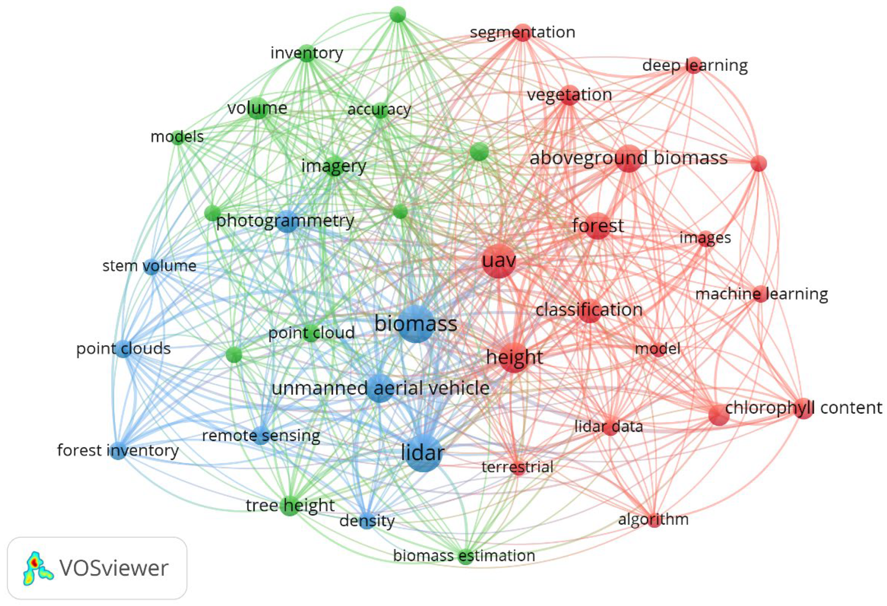

| Cur. No. | Keyword | Occurrences | Total Link Strength |
|---|---|---|---|
| 1 | biomass | 38 | 158 |
| 2 | LIDAR | 37 | 145 |
| 3 | height | 25 | 114 |
| 4 | UAV | 31 | 112 |
| 5 | Unmanned Aerial Vehicle | 22 | 81 |
| 6 | forest | 19 | 75 |
| 7 | classification | 16 | 71 |
| 8 | aboveground biomass | 21 | 66 |
| 9 | photogrammetry | 14 | 65 |
| 10 | imagery | 11 | 55 |
| 11 | vegetation | 11 | 55 |
| 12 | point clouds | 9 | 51 |
| 13 | volume | 13 | 45 |
| 14 | forest inventory | 9 | 44 |
| 15 | remote sensing | 10 | 43 |
| 16 | tree height | 11 | 43 |
| Cur. No. | Tree Species | Country | Citing Article |
|---|---|---|---|
| 1 | Abies faxoniana Franch. | China | You-yun et al., 2016 [78] |
| 2 | Apple orchard | Spain | Apolo-Apolo et al., 2020a [79] |
| 3 | Carob trees (Prosopis sp.) | Peru | Chumbimune-Vivanco et al., 2025 [60] |
| 4 | Chesnuts orchard | Italy | Di Gennaro et al., 2020 [80] |
| 5 | Chinese fir forest (Cunninghamia lanceolata (Lamb.) Hook.) | China | Chen et al., 2024 [81] |
| 6 | Cinnamomum camphora (L.) J. Presl. | China | Wang et al., 2023 [82] |
| 7 | Citrus trees | Spain | Apolo-Apolo et al., 2020b [83] |
| 8 | Eucalyptus sp. | Portugal | Guerra-Hernandez et al., 2017 [84] |
| 9 | Ginkgo sp. | China | Qiu et al., 2024 [85] |
| 10 | Laricio-Pine forest | Italy | De Luca et al., 2023 [86] |
| 11 | Larix kaempferi (Lamb.) Carrière | Japan | Karthigesu et al., 2023 [87] |
| 12 | Litchi (Litchi chinensis Sonn.) | China | Bai et al., 2023 [88] |
| 13 | Liriodendron sino-americanum forests | China | Shi et al., 2025 [89] |
| 14 | Malania oleifera Chun et S. K. Lee | China | Gong et al., 2023 [90] |
| 15 | Mango orchard | Pakistan | Afsar et al., 2024 [62] |
| 16 | Mangrove forest | China, Kenya, Vietnam | Chen et al., 2023 [91]; Fu et al., 2025 [92]; Duan et al., 2025 [64]; Ngo et al., 2023 [93] |
| 17 | Mediterranean riparian forest | Portugal | Fernandes et al., 2020 [94] |
| 18 | Norway spruce (Picea abies L. Karst.) and beech (Fagus sylvatica L.) forest | Romania | Apostol et al., 2020 [95]; Tudoran et al., 2021 [96] |
| 19 | Oil palm (Elaeis guineensis) | Malaysia | Fawcett et al., 2019 [97] |
| 20 | Olive trees | Italy | Caruso et al., 2019 [98] |
| 21 | Orange trees | Spain | Estornell et al., 2024 [99] |
| 22 | Peach tree | China | Hu et al., 2022 [100] |
| 23 | Picea abies L. | Czech Republic | Panagiotidis et al., 2017 [29] |
| 24 | Pine forest | Greece | Barmpoutis et al., 2020 [101] |
| 25 | Pinus eldarica ten. | Iran | Hosingholizade et al., 2023 [102] |
| 26 | Pinus halepensis Mill. | Spain | Nemmaoui et al., 2024 [103] |
| 27 | Pinus massoniana Lamb. | China | Liao et al., 2022 [104] |
| 28 | Pinus pinea L. | Portugal | Guerra-Hernandez et al., 2017 [84] |
| 29 | Pinus sylvestris L. | Poland | Janiec et al., 2024 [70] |
| 30 | Quercus ilex L. | Portugal | Juan-Ovejero et al., 2023 [105] |
| 31 | Sonneratia apetala Blanco | China | Yu et al., 2023 [106] |
| 32 | Tectona grandis L. | Costa Rica | Porras-Granados et al., 2022 [107] |
| 33 | Tropical woodland | Malawi | Domingo et al., 2019 [108] |
Disclaimer/Publisher’s Note: The statements, opinions and data contained in all publications are solely those of the individual author(s) and contributor(s) and not of MDPI and/or the editor(s). MDPI and/or the editor(s) disclaim responsibility for any injury to people or property resulting from any ideas, methods, instructions or products referred to in the content. |
© 2026 by the authors. Licensee MDPI, Basel, Switzerland. This article is an open access article distributed under the terms and conditions of the Creative Commons Attribution (CC BY) license.
Share and Cite
Munteanu, D.; Moldovanu, S.; Murariu, G.; Dinca, L. Sustainable Estimation of Tree Biomass and Volume Using UAV Imagery: A Comprehensive Review. Sustainability 2026, 18, 1095. https://doi.org/10.3390/su18021095
Munteanu D, Moldovanu S, Murariu G, Dinca L. Sustainable Estimation of Tree Biomass and Volume Using UAV Imagery: A Comprehensive Review. Sustainability. 2026; 18(2):1095. https://doi.org/10.3390/su18021095
Chicago/Turabian StyleMunteanu, Dan, Simona Moldovanu, Gabriel Murariu, and Lucian Dinca. 2026. "Sustainable Estimation of Tree Biomass and Volume Using UAV Imagery: A Comprehensive Review" Sustainability 18, no. 2: 1095. https://doi.org/10.3390/su18021095
APA StyleMunteanu, D., Moldovanu, S., Murariu, G., & Dinca, L. (2026). Sustainable Estimation of Tree Biomass and Volume Using UAV Imagery: A Comprehensive Review. Sustainability, 18(2), 1095. https://doi.org/10.3390/su18021095