Article

Research on the Construction of a County-Level Urban-Rural Equivalent Comprehensive Evaluation System Under the Community Theory


1
School of Architecture and Planning, Fujian University of Technology, Fuzhou 350118, China
2
Observation and Research Station of Land Consolidation in Hilly Region of Southeast China, MNR, Fuzhou 350001, China
3
Research Center for the Integration and Development of Marine Culture and Technology, Fujian Provincial Social Science Research Base, Fujian University of Technology, Fuzhou 350118, China
*
Author to whom correspondence should be addressed.
Co-first author.
Sustainability 2026, 18(10), 5153; https://doi.org/10.3390/su18105153
Submission received: 23 April 2026 / Revised: 18 May 2026 / Accepted: 19 May 2026 / Published: 20 May 2026

Abstract

Traditional evaluation systems in the current process of urban–rural integration are guided by the goal of “equalization.” They predominantly focus on material facilities and services while neglecting both the integration of socio-cultural dimensions and the disparities between urban and rural areas. Consequently, they are ill-equipped to systematically assess or facilitate the formation of urban–rural communities. To address this gap, this study, grounded in community theory, constructs a county-level comprehensive evaluation framework for urban–rural equivalence that integrates the three dimensions of “material, service, and social” spheres, encompassing material infrastructure, socioeconomic services, and cultural identity. This framework consists of three dimensions, seven criteria, and twenty-one indicators, which are operationalized through statistical data, questionnaire surveys, and field investigations. An empirical application to Xiapu County, Fujian Province, yields a composite urban–rural equivalence index of 0.8184, indicating a moderate level of equivalence, with relatively balanced development across the three dimensions. Furthermore, diagnostic analysis reveals that the key bottlenecks constraining progress toward a higher level of equivalence are not absolute resource shortages but rather the organizational efficiency of spatial linkages, the grassroots-level transmission capacity of public services, and deficiencies in social identity and public participation. Accordingly, differentiated planning response pathways are proposed from the three perspectives of territorial community, governance community, and relational community. By constructing a multidimensional comprehensive evaluation framework, this study advances urban–rural equivalence assessment from mere “disparity description” toward “mechanism diagnosis,” thereby offering a more systematic and operationally feasible evaluation tool and strategic reference for county-level urban–rural integration.

1. Introduction

Against the backdrop of deepening global urbanization, the relationship between urban and rural areas remains a central issue in regional development and spatial planning [1]. As development paradigms increasingly embrace the integrated pursuit of inclusiveness, sustainability, and quality of life, achieving balanced and integrated urban–rural development has emerged as a worldwide challenge [2,3,4,5]. In China, the coordinated advancement of the new-type urbanization and rural revitalization strategies signals a new phase in urban–rural relations, one oriented toward integration [6]. The county, serving as the transitional interface between the city and the countryside, constitutes a critical unit where urban and rural elements intersect and functions complement each other; thus, the quality of its urban–rural integration directly determines the effectiveness of national policy implementation at the grassroots level [7,8].
Conventionally, evaluations of urban–rural development have predominantly emphasized material dimensions such as economic growth and infrastructure, aiming to narrow the “hardware” gap [9,10,11]. However, a growing consensus holds that genuine integration entails not only convergence in material conditions but also, more importantly, the bridging of deeper social dimensions, including social equity, service accessibility, cultural identity, and a sense of belonging [11,12]. The neglect of these non-material bonds may lead to a predicament of “development without integration,” whereby physical landscapes improve, while social cohesion fails to advance correspondingly. Consequently, there is both theoretical urgency and practical significance in developing an evaluation framework that more comprehensively captures the essence of urban–rural integration, particularly one that accounts for socioeconomic linkages and subjective perceptions.
A review of the existing literature reveals that the concept of urban–rural equivalence offers an important lens for understanding integration goals that transcend mere “equalization” [13,14,15]. Originating in Europe, this concept centers on the pursuit of “equivalent” quality of life and development opportunities for urban and rural residents across different locations, rather than the homogenization of lifestyles [16]. Existing research has largely proceeded along two pathways. The first emphasizes the comparison of objective material conditions, constructing comprehensive evaluation systems that encompass the economy, environment, infrastructure, and public services [17,18,19,20,21]. The second attends to residents’ subjective well-being and satisfaction [22,23,24,25]. Together, these strands of research have advanced the operationalization and measurement of urban–rural equivalence from conceptual abstraction toward empirical application.
Nevertheless, extant methodological frameworks exhibit certain limitations. First, most evaluation systems are characterized by a “dimension-parallel, indicator-accumulating” structure [26,27,28], lacking a core integrative thread grounded in substantive theory that can bridge the material and non-material realms. Consequently, the explanatory power and planning relevance of the resulting assessments remain constrained, offering limited insight into the question of how to promote integration. Second, attention to non-material dimensions has largely been confined to individual subjective satisfaction [24,25], failing to effectively capture the relational elements that bind urban and rural social actors into an organic whole, such as trust, mutual assistance, participation, and a sense of belonging. These very elements constitute the social fabric that sustains viable and cohesive communal life.
The root of these methodological limitations lies in an insufficient exploration of the social and processual nature of urban–rural integration. Integration is not merely a reallocation of space and resources; it is fundamentally a reshaping of social relations and a reconstruction of community. Recent research has begun to shift in this direction. For instance, studies on public services have incorporated socio-cultural factors such as accessibility and user experience [29,30,31], while others from the perspective of community governance have emphasized resident participation and social capital [32,33,34,35]. These converging lines of inquiry point to a core concept: community. In classical sociology, community refers to social bonds formed on the basis of shared locality, emotions, values, and common interests [36]. Introducing this concept into urban–rural studies implies treating urban and rural areas as an integrated whole with intertwined fates and mutual interdependence, where the goal of integration is to cultivate a state of development characterized by shared interests, co-responsibility, and emotional cohesion. This provides a highly promising theoretical framework for integrative research: one that not only requires a material foundation (territorial community) and encompasses service delivery and governance mechanisms (governance community) [37] but also, more fundamentally, points toward social identity and relational networks (relational community) [38,39,40,41]. Therefore, examining urban–rural equivalence from a community perspective can remedy the key deficiencies of current evaluation systems, namely, their weak social dimensions and loose structures, by subsuming disparate indicators under the central theme of “connection and identity,” thereby bringing evaluations closer to the social essence of integration.
Based on the above reasoning, this study aims to construct an evaluation system from an integrated community perspective that can profoundly capture the essence of urban–rural integration development, to diagnose the current characteristics and critical shortcomings of county-level urban–rural integration, and accordingly to propose targeted planning and governance strategies. To this end, this study seeks to achieve integration and innovation in three respects. At the theoretical level, it systematically synthesizes urban–rural relations and community theory to develop a triadic analytical framework of territorial community, governance community, and relational community. At the methodological level, it transcends the limitations of conventional data by integrating objective infrastructure and service operation data with subjective questionnaire surveys, thereby constructing a comprehensive evaluation system capable of capturing both “hard conditions” and “soft linkages.” At the practical level, it emphasizes a dialogue between evaluation and strategy, formulating a systematic planning response for promoting county-level urban–rural community building from three aspects: spatial optimization, service coordination, and socio-cultural cultivation.
In summary, this study does not seek to overturn conventional methods of urban–rural evaluation. Rather, it attempts to remedy their insufficient attention to socio-cultural dimensions by introducing the integrative perspective of community, thereby advancing urban–rural equivalence assessment from mere “disparity description” toward “mechanism diagnosis.” This study offers a richer theoretical lens for understanding the complex connotations of county-level urban–rural integration, as well as a more operationally feasible evaluation tool and strategic insights for urban–rural planning practices aimed at fostering social cohesion and enhancing human well-being.

2. Theoretical Framework Construction for County-Level Urban–Rural Equivalence from a Community Perspective

An Analytical Framework for County-Level Urban–Rural Equivalence from a Community Perspective

The concept of “urban–rural equivalence” originates from the German scholarly idea of “urban–rural equivalence” (Gleichwertigkeit der Lebensverhältnisse) in rural development practice. Its core meaning is the pursuit of substantive equality for urban and rural residents in terms of “quality of life, development opportunities, and rights protection,” rather than uniformity in economic scale or landscape form. China’s “coordinated urban–rural development” emphasizes breaking down the urban–rural dual structure and promoting the rational allocation of factors; “urban–rural integration” focuses on achieving overall coordination of urban and rural spaces in infrastructure, public services, and planning management; and “integrated urban–rural development” is a strategic deepening in the new era, aiming to promote the free flow of urban and rural factors, the balanced allocation of public resources, and the synergistic complementarity of industrial development, ultimately achieving common prosperity. From “coordination” to “integration,” the policy evolution reflects a sublimation from reducing disparities to building a new type of urban–rural relationship. “Urban–rural equivalence” is highly consistent with the above-mentioned Chinese policy goals in terms of value orientation and can be regarded as an operational social goal interpretation and measurement perspective for achieving “integration” and “coordination”.
The concept of urban–rural equivalence aims to address the urban–rural dichotomy by pursuing substantive equality in the quality of life and development opportunities between urban and rural residents [42]. However, existing research and practice have predominantly focused on measuring material dimensions such as economic growth, infrastructure, and public services. Although this approach has been essential for revealing inequalities in resource allocation, a more profound dilemma of integration has become increasingly salient in regions where material conditions have significantly improved. Issues such as weak social bonds, cultural identity alienation, and insufficient public participation have hindered the transition from “proximity in form” to “substantive integration” in urban–rural relations. This suggests that the existing analytical frameworks, dominated by material dimensions, have inherent limitations and are inadequate for fully explaining or addressing the non-material and relational dimensions that pertain to residents’ daily living experiences, social relationships, and cultural psychological belonging.
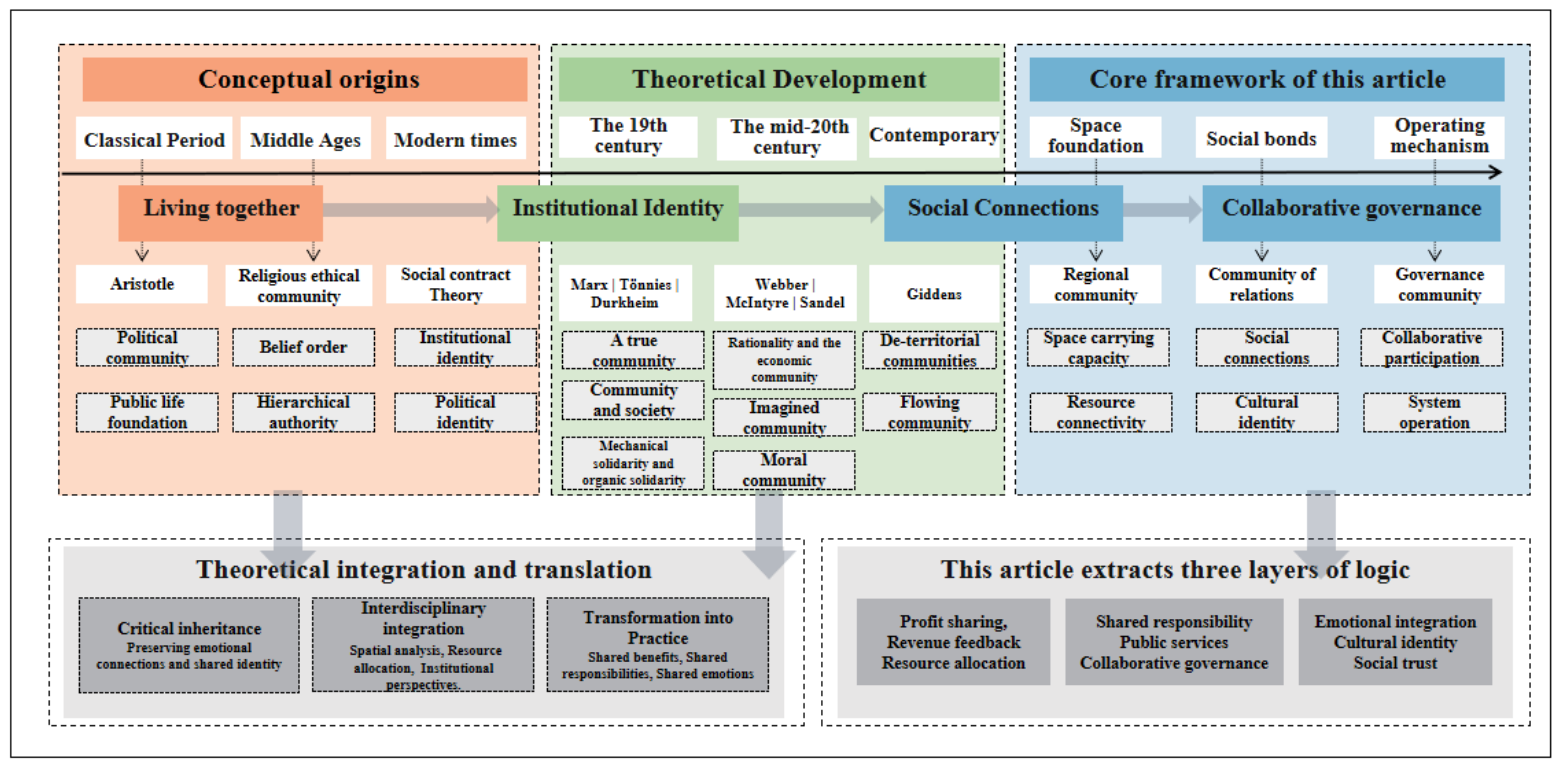
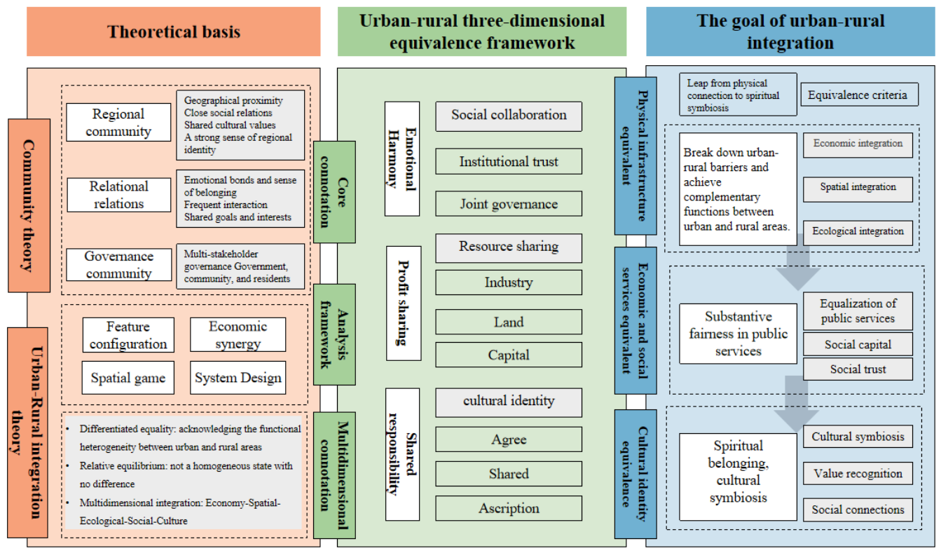
To transcend these limitations, this study introduces the theoretical perspective of community (Figure 1) in order to construct an analytical framework capable of more comprehensively capturing the multidimensional connotations of urban–rural equivalence. The concept of community has a long-standing tradition in the social sciences. Its connotations have evolved from Tönnies’s notion of a traditional Gemeinschaft, based on blood, locality, and emotional ties, toward a modern understanding of community that increasingly emphasizes shared interests, institutional collaboration, public participation, and identity construction. The theoretical value of applying this perspective to the study of county-level urban–rural relations lies in its provision of an integrative lens. It prompts us to view the county not merely as an administrative unit or an economic space but rather as a potential “community of living” and “community of development” co-constituted by urban and rural residents. From this perspective, urban–rural equivalence implies not only the balanced distribution of “hardware”, such as roads, schools, and hospitals, but also, and more crucially, the extent to which a smooth network of factor flows, a highly coordinated governance structure, and deep-seated social trust and cultural identity have been fostered within the county territory. In other words, the community perspective extends the connotation of urban–rural equivalence from a static “gap-narrowing” approach to a dynamic process of “connection and integration.” It focuses on whether organic linkages characterized by shared interests, co-responsibility, and emotional cohesion have emerged between urban and rural areas, based on spatial proximity and facility sharing.
Based on a systematic review of classical community theory and an understanding of the specific characteristics of contemporary urban–rural relations in Chinese counties, this study refines and reconstructs community theory in a manner tailored to the present research context (Figure 2). We eschew treating community as an undifferentiated whole or a nostalgic trope. Instead, we extract three interrelated and progressively deepening analytical dimensions to systematically deconstruct the complex composition of county-level urban–rural equivalence. The first dimension is territorial community. This corresponds to the material–spatial foundation upon which community formation rests. In the county context, it concerns the physical carriers and connective networks that underpin the shared living of urban and rural populations. These include the connectivity efficiency of transport infrastructure, the spatial layout of settlements, the integrity of the ecological base, and the organizational logic of life circles. A robust territorial community implies that urban and rural residents can move, reside, and interact relatively freely and conveniently across geographical divides within the county space, thereby sharing spatial resources and ecological amenities. The second dimension is governance community. This points to the institutional and regulatory aspects that sustain the functioning of a community. It focuses specifically on whether a smooth “transmission–reception” mechanism has been established across different administrative and service levels—county, town, and village—with respect to public service provision, social policy implementation, and the distribution of development opportunities. The maturity of a governance community is reflected in the extent to which public services such as education, healthcare, elderly care, and culture are not merely “spatially allocated,” but are also “efficiently operationalized within the system and effectively received at the grassroots level,” while ensuring urban and rural residents’ sense of fairness before institutions and their trust in the governance system. The third dimension is relational community. This constitutes the most fundamental social and psychological layer of community, involving identity, trust, mutual assistance, and participation among its members. In the context of urban–rural relations, it is manifested in whether urban and rural residents have developed a sense of belonging to their county, whether they embrace and identify with each other’s different lifestyles and cultural backgrounds, whether they have established networks of mutual trust and assistance in daily interactions and social activities, and whether they have effective channels for participating in public affairs. Relational community represents the highest level of urban–rural integration and the most challenging “soft power” to cultivate.
The core idea of regional community originates from the theories of “place” and “spatial production” in human geography and the theory of “spatial interaction” in regional science. It emphasizes that urban–rural equivalence is primarily a geographical process, focusing on the spatial distribution, connection, and functional integration of material elements (infrastructure, ecological background, and settlements). Its theoretical goal is to overcome spatial “fragmentation” and “isolation,” achieving the free flow and efficient allocation of factors, which responds to classic economic issues regarding transaction costs and agglomeration economies. Therefore, regional community constitutes the material foundation and spatial carrier of urban–rural equivalence.
The core of governance community draws upon the theories of “polycentric governance” and “collaborative governance” in public administration and political science, as well as the discourse in institutional economics on how “institutional arrangements” shape development. It argues that urban–rural equivalence is essentially a political and institutional process. Physical spatial connection alone is insufficient to achieve equivalence; a fair, efficient, and inclusive set of institutional arrangements and governance procedures is needed to coordinate the interests of multiple stakeholders (government, market, society), allocate public resources, and formulate and implement spatial planning. Governance community thus constitutes the institutional guarantee and driving mechanism for achieving urban–rural equivalence.
The theoretical core of relational communities is deeply rooted in the sociological and community studies theories of “social capital,” “community,” and “identity politics,” as well as the exploration of “sense of place” and “sense of belonging” in human geography. It points out that urban–rural equivalence must ultimately be a social and cultural process. Sustainable equivalence depends on residents’ emotional, identity, and cultural identification with the “urban–rural community,” and on social connections based on trust, reciprocity, and shared norms. Relational communities focus on social integration, cultural prosperity, and subjective participation, constituting the socio-cultural core and source of meaning for maintaining urban–rural equivalence.
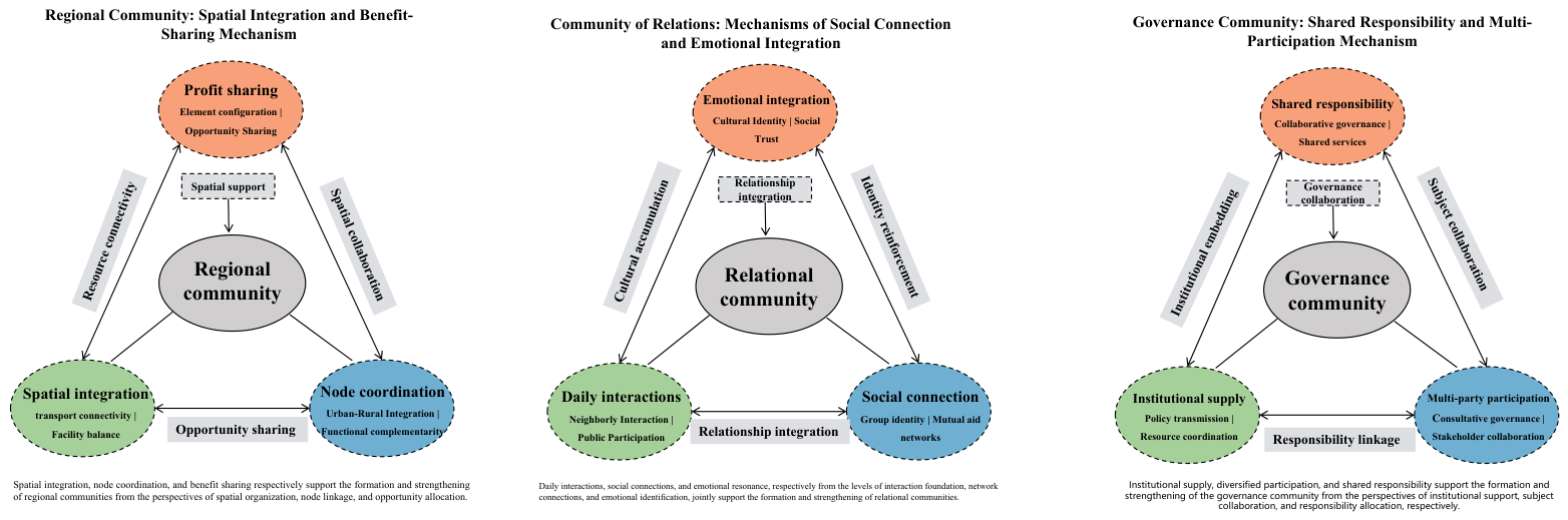
By integrating the three reconstructed dimensions of community, namely, territorial community, governance community, and relational community, with the specific evaluation of urban–rural equivalence, this study arrives at the core analytical framework for county-level urban–rural triadic equivalence from a community perspective (Figure 3). This framework operationalizes the abstract concept of community into three concrete evaluative dimensions. First, the territorial community dimension is operationalized as physical infrastructure equivalence. This dimension primarily assesses the degree of proximity and supporting conditions between urban and rural areas in terms of economic development levels, resident income, spatial land use, ecological quality, and the configuration of transport and municipal infrastructure. It seeks to answer whether the “foundation” for shared urban–rural development is solid and whether spatial linkages are smooth. Second, the governance community dimension is operationalized as socioeconomic service equivalence. This dimension transcends the static possession of facilities to examine in depth the accessibility, usability convenience, quality equity, and residents’ perceptions of institutional fairness and their own sense of participation in key public services such as education, healthcare, elderly care, public culture, commercial services, and digital services across urban and rural areas. It aims to assess the synergistic efficacy of public service networks and governance systems. Third, the relational community dimension is operationalized as cultural identity equivalence. This dimension directly attends to residents’ subjective world and social interactions. By measuring residents’ local cultural identity, identity acceptance, social trust, frequency of daily interactions, and cultural participation, it reveals the psychological foundations and relational network conditions of urban–rural social integration.
The establishment of this triadic analytical framework realizes a paradigmatic expansion in the understanding of urban–rural equivalence, moving from a unidimensional to a comprehensive perspective, from hardware to software, and from structure to relations. It no longer treats material infrastructure, socioeconomic services, and cultural social relations as disconnected parallel dimensions but rather understands them as an organic whole in which each dimension influences and shapes the others. Spatial connectivity and infrastructure (territorial community) constitute the material foundation for the delivery of public services and the occurrence of social interaction. Efficient coordination of public services and institutional fairness (governance community) can significantly enhance residents’ sense of gain and their trust in the community, thereby facilitating social bonding. Conversely, deep cultural identity and dense social networks (relational community) can improve the quality of public participation, consolidate governance effectiveness, and endow spatial places with meaning and vitality. Thus, through this integrative perspective, the proposed framework aims to systematically diagnose the overall state and internal structure of county-level urban–rural equivalence, revealing not only “where the gaps lie” but also, more incisively, “how the connections are made,” thereby providing an analytical basis that combines theoretical insight with practical guidance for formulating planning strategies to promote deep urban–rural integration. On this basis, this study delineates three evaluative dimensions for county-level urban–rural equivalence (Figure 3).
This study’s concept of “urban–rural equivalence” transcends the traditional paradigm of developmentalism and modernist planning’s pursuit of universality and homogenization, essentially aligning with a postmodernist spatial cognition. From this perspective, urban–rural equivalence at the county level cannot be simplified to a static state of “modernist homogenization” achievable through equalization of infrastructure and public services [43,44]. Similarly, it is not equivalent to the unconditional, fragmented acceptance of local differences, diverse narratives, and relative values championed by pure postmodernism. Instead, it presents a multi-layered, dynamic process of continuous oscillation and negotiation between “the integration of material space” and “the attribution of symbolic relationships.” True equivalence signifies a dynamic, contextualized integration among measurable geographical conditions, efficient and collaborative institutional arrangements, actively shared cultural identity, and residents’ genuine and differentiated life experiences. Therefore, this study’s starting point is a transcendence of the traditional “technocrat-indicator-driven” paradigm, aiming to explore a comprehensive understanding framework encompassing multiple dimensions of material, institutional, and meaning.

3. Research Methods

3.1. Study Area and Data Sources

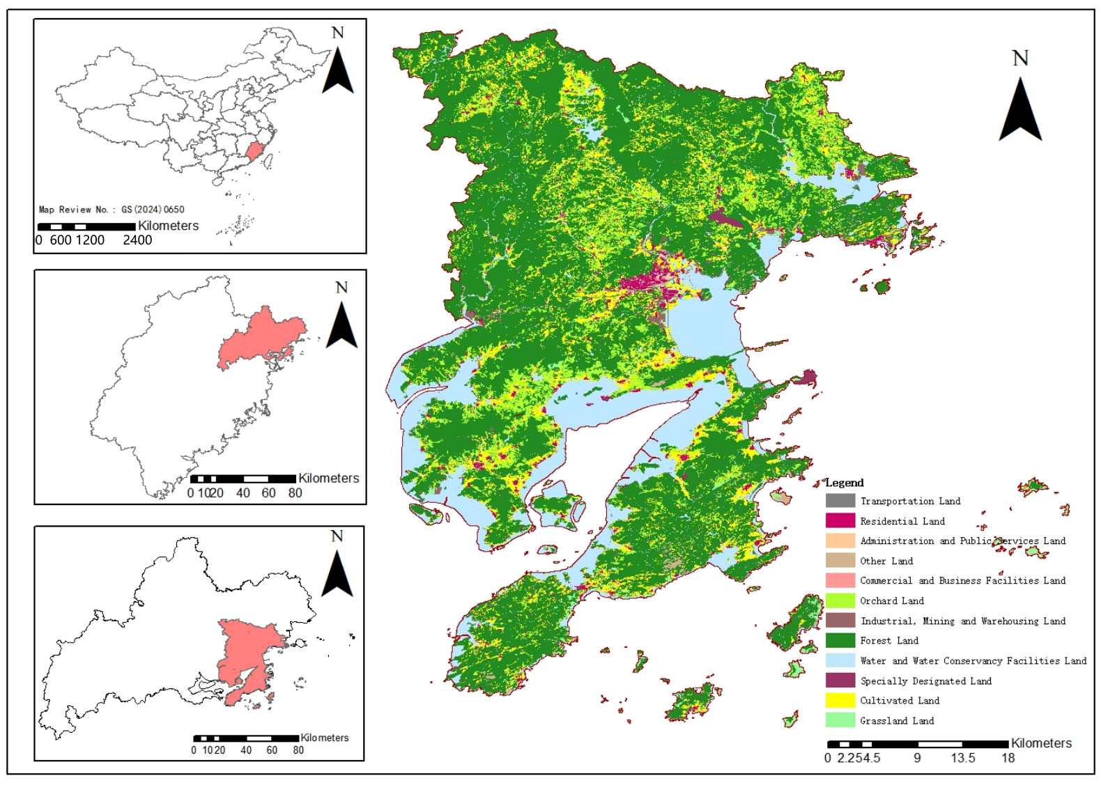
This study selected Xiapu County, Ningde City, Fujian Province, as the empirical case (Figure 4). Xiapu County integrates the characteristics of mountainous, coastal, and peri-urban areas and is currently undergoing a rapid transition in its urban–rural structure. The challenge of reconciling high-intensity urbanization with the preservation of characteristic resources, which this county faces, is highly representative of counties along the southeastern coast of China. In recent years, the county has made progress in infrastructure, urban construction, and public services, with continuous improvements in transport connectivity and the initial formation of basic service systems for education, healthcare, elderly care, and public culture. Nevertheless, disparities persist across different areas in terms of service accessibility, daily convenience, and social participation. This coexistence of coastal, mountainous, and island contexts well captures the complexity of county-level urban–rural relations, thereby providing a suitable empirical basis for examining urban–rural equivalence from a community perspective. A horizontal comparison shows that Xiapu County still lags behind the provincial average in some macroeconomic indicators. For example, its per capita GDP in 2024 (123,400 yuan) was lower than the Fujian provincial average (137,920 yuan), and its urbanization rate of permanent residents (64.4%) was also lower than the provincial average (71.80%). However, this precisely illustrates that its development bottleneck is no longer simply a matter of insufficient “quantity.” Vertical and structural evidence shows that Xiapu County has been selected as one of the “Top Ten” counties for county-level economic development in Fujian Province for three consecutive years. Decisive progress has been made in infrastructure “hard coverage” (e.g., 51.2% of administrative villages in the county have two-lane roads, and network coverage exceeds 90%), and fiscal investment in public services such as education and healthcare has continued to increase. These facts collectively point to the fact that the main contradiction in Xiapu County’s urban and rural development has shifted from the early absolute issue of “availability” (such as road access, internet access, and school construction) to the current issues of “quality and efficiency” and “coordination” (such as spatial connectivity efficiency, service delivery quality, and social integration). Therefore, the evaluation system and conclusions of this study focus on the latter, which is a precise response to its development entering a new stage. Thus, Xiapu County effectively presents the complexity of urban–rural relations within the county, providing a suitable case study for examining urban–rural equivalence from a community perspective.
Data for this study were derived from the Xiapu County Statistical Yearbook, statistical bulletins, and territorial spatial planning documents, covering indicators such as per capita gross regional product, resident income, industrial structure, urbanization rate, and land use. The questionnaire survey was designed based on the “Evaluation Indicator System for County-Level Urban–Rural Equivalence from a Community Perspective,” encompassing dimensions such as ecological environment perception, facility and service accessibility, institutional safeguards, cultural identity, and social trust.
The “community” perspective advocated in this paper is not a simple transplantation of the traditional sociological concept of “community,” which is based on close geographical and kinship ties and emphasizes high homogeneity and a small scale. The county, as the “end of the city and beginning of the countryside,” is a key spatial unit where urban and rural elements converge, functions complement each other, and governance is coordinated. Applying community theory to this scale is reasonable because this study grasps and operationally reconstructs the core of the classic theory. We discard its nostalgic imagery and micro-scale limitations, instead extracting its core essence of “social connection” and “communicative living” and deconstructing it into three mutually supportive and logically progressive analytical dimensions: “region, governance, and relationship.” This framework aims to systematically depict, at the meso-level of the county, how urban and rural areas move from division to integration through shared spatial infrastructure and facilities networks (regional community), coordinated public services and institutional arrangements (governance community), and harmonious social identity and interactive relationships (relational community). Therefore, by taking county-level units as the research object, we can systematically observe and assess whether and to what extent a complex community of development and life is being formed between urban and rural areas, characterized by shared interests, shared responsibilities, and emotional resonance.

3.2. Indicator Construction and Questionnaire Design

3.2.1. Indicator Construction

Grounded in the theoretical framework from a community perspective, this study constructed a multidimensional, multilevel comprehensive evaluation indicator system for county-level urban–rural equivalence (Table 1). The system is not arbitrarily constructed. Its core rationale derives from reinterpreting urban–rural equivalence through community theory and the associated need for operationalization. Traditional assessments of urban–rural disparities have largely focused on quantifiable material and economic indicators. This study, however, argues that genuine “equivalence” is the outcome of the synergistic interplay among three dimensions: territorial community (material–spatial foundation), governance community (institutional and service operation), and relational community (socio-psychological bonding). Consequently, the fundamental basis for indicator formation lies in transforming these three abstract theoretical dimensions into observable, measurable, and comparable concrete variables, thereby enabling a systematic diagnosis of the comprehensive state of urban–rural integration in terms of “hardware” configuration, “software” operation, and “heartware” connectivity.
The evaluation index system constructed in this study follows a comprehensive approach of “theory-driven, literature reference, expert consultation, and field verification.” First, the initial selection of indicators is deeply rooted in the theoretical framework of the “region–governance–relationship” triadic community mentioned earlier. Based on this, extensive references were made to the national “Evaluation Index System for County-level Urbanization Construction,” relevant research on the localization assessment of the United Nations Sustainable Development Goals (SDGs) [45,46], and the relevant literature on urban and rural development evaluation in recent years [47,48,49].
Table 1. Evaluation indicator system for urban–rural equivalence from a community.
HierarchyCriterion LayerIndicator CodeIndicatorIndicator DescriptionBenchmark Basis
Urban–Rural Economic and Spatial Resource Coordination (A1 Physical Infrastructure Equivalence)Economic Development Coordination (B1)C1GDP per CapitaOverall Level of urban–rural Economic DevelopmentBenchmark of RMB 130,000 per capita; level attainment model [50]
C2Urban–Rural Income GapUrban-to-rural ratio of per capita disposable incomeBenchmark ratio of 1.5; gap convergence model [50]
C3Share of Non-Agricultural IndustriesShare of rural non-agricultural output valueBenchmark at 80% of the mean for comparable coastal counties; level attainment model
Land Use and Ecological Foundation (B2)C4Urban–Rural Per Capita Land AreaUrban-to-rural ratio of per capita construction land areaOptimal interval of 0.24–0.36; interval-optimal model
C5Urbanization RateShare of permanent urban populationStage-specific equivalence benchmark of 75%; level attainment model
C6Eco-Environmental ConditionsComposite perception of air, water, green space, and related eco-environmental conditionsFive-point Likert scale; benchmark of four points
Infrastructure Provision (B3)C7Infrastructure Service LevelComposite perception of accessibility, reliability, and convenience of water supply, power supply, roads, and waste managementFive-point Likert scale; benchmark of four points
Public Services and Institutional Support (A2 Socioeconomic Service Equivalence)Public Service Accessibility and Perceived Attainment (B4)C8Perceived Accessibility of Educational ServicesPerceived accessibility and convenience of nearby preschool, primary, and junior secondary educationFive-point Likert scale; benchmark of four points
C9Accessibility of Medical FacilitiesPerceived accessibility and use convenience of primary healthcare facilities, including township health centers and outpatient clinicsFive-point Likert scale; benchmark of four points
C10Transport Accessibility and ConveniencePerceived convenience of urban–rural commuting and public transport coverageFive-point Likert scale; benchmark of four points
C11Public Cultural Facility ServicesPerceived accessibility and use convenience of libraries, cultural stations, and rural reading roomsFive-point Likert scale; benchmark of four points
C12Accessibility of Commercial Service FacilitiesPerceived convenience of farmers’ markets, supermarkets, convenience stores, and related commercial service facilitiesFive-point Likert scale; benchmark of four points
C13Convenience of Digital ServicesPerceived convenience of internet access, 5G coverage, and online platforms, including medical insurance payment and e-government servicesFive-point Likert scale; benchmark of four points
Social Security and Institutions (B5)C14Institutional Fairness and TrustOverall trust in the fairness of local decision-making and the responsiveness of local governmentFive-point Likert scale; benchmark of four points
C15Resident ParticipationPerceived effectiveness of government consultation and feedback mechanismsFive-point Likert scale; benchmark of four points
Urban–Rural Cultural Identity and Social Relations (A3 Cultural Identity and Social Connectedness Equivalence)Cultural Identity and Belonging (B6)C16Cultural Identity and Sense of BelongingPerceived identification with local culture, local social space, and the community of everyday lifeFive-point Likert scale; benchmark of four points
C17Identity RecognitionDegree of acceptance of the cultural atmosphere, way of life, and social roles within the urban–rural social spaceFive-point Likert scale; benchmark of four points
C18Participation in Cultural ActivitiesPerceived frequency of and willingness to participate in cultural exchange activitiesFive-point Likert scale; benchmark of four points
Social Relations and Collaboration (B7)C19Interpersonal Mutual-Aid TrustLevel of mutual-aid trust among residentsFive-point Likert scale; benchmark of four points
C20Trust in Community OrganizationsLevel of trust in community fairness, transparency in public affairs, and community organizations, residents’ committees, and villagers’ committeesFive-point Likert scale; benchmark of four points
C21Frequency of Resident InteractionFrequency of face-to-face and online interaction, neighborhood mutual aid, and community communicationFive-point Likert scale; benchmark of four points
Based on this, the construction of the indicator system follows a progressive specification pathway from “theoretical dimensions” to “criteria levels” to “specific indicators.” First, the three community dimensions are operationalized into three first-level evaluation dimensions: physical infrastructure equivalence (territorial community), socioeconomic service equivalence (governance community), and cultural identity and social connection equivalence (relational community). This design transcends the conventional separation between material and non-material aspects, emphasizing that urban–rural equivalence encompasses spatial support, service efficacy, and social capital. Second, to capture internal differentiation within each dimension, seven criteria levels are established as a bridge between the first-level dimensions and specific indicators. For instance, physical infrastructure equivalence is disaggregated into “coordination of urban–rural economy and spatial resources,” “spatial land use and ecological foundation,” and “infrastructure configuration.” Socioeconomic service equivalence is disaggregated into “accessibility and perceived gain of public services” and “institutional safeguards.” Cultural identity and social connection equivalence is disaggregated into “cultural identity and sense of belonging” and “social relations and cooperation.” Such a structural design ensures that the evaluation not only covers the core domains of urban–rural relations but also captures in depth the key issues within each domain.
Based on the initial indicator pool, this study conducted two rounds of expert consultation using the Delphi method. Fifteen invited experts, covering urban and rural planning, regional economics, public administration, and sociology, scored the necessity, accessibility, and representativeness of the indicators using a questionnaire (Likeert 5-point scale). For the selection criteria, indicators with a mean score ≥ 4.0 and a coefficient of variation < 0.25 were retained, ultimately forming a final system comprising 6 criterion levels and 21 specific indicators. The indicator weights were determined using the analytic hierarchy process (AHP), based on Saaty’s 1–9 scale. The same group of experts conducted pairwise comparisons of indicators at each level, constructing a judgment matrix. Yaahp 10 software was used to process the expert scores, calculate the weights of each indicator, and perform consistency checks. The consistency ratio (CR) of all judgment matrices was less than 0.1 (specific values ranged from 0.02 to 0.08), passing the test and indicating that the experts’ judgment logic was consistent and the weight results were acceptable. The final weights were the geometric mean of the expert judgments. To test the robustness of the weight allocation, this study further conducted a sensitivity analysis of the weights. By adjusting the weights of the criteria layer by 10% up and down respectively, fluctuations in the comprehensive index value and ranking were observed. The analysis shows that within a reasonable fluctuation range, the comprehensive evaluation results remain stable, with the comprehensive index value of Xiapu County fluctuating between 0.798 and 0.837. The overall judgment of “medium-high equivalence” and the conclusion of key shortcomings have not fundamentally changed, which proves that the evaluation model has strong robustness.
The final indicator system features a clear three-tier hierarchical structure, comprising three first-level dimensions, seven criteria levels, and twenty-one specific indicators. In the selection of indicators, this study places particular emphasis on integrating objective statistical data with residents’ subjective perception data in order to overcome the biases inherent in any single data source. Specifically, for the physical infrastructure equivalence dimension, objective statistical indicators such as per capita gross regional product, urban–rural income gap, proportion of non-agricultural industries, per capita urban and rural land use area, and urbanization rate are primarily adopted, supplemented by subjective perception indicators (C6, C7) concerning residents’ views on ecological environment and infrastructure service levels. For the socioeconomic service equivalence dimension, the assessment relies entirely on questionnaire surveys, measuring residents’ perceptions of accessibility and convenience in education, healthcare, transport, public culture, commercial services, and digital services (C8–C13), as well as their evaluations of institutional fairness and their own participation (C14, C15). For the cultural identity and social connection equivalence dimension, questionnaire surveys are likewise employed to measure residents’ local cultural identity, identity acceptance, and participation in cultural activities (C16–C18), along with interpersonal trust, trust in community organizations, and frequency of daily interactions (C19–C21). This “objective–subjective combined” indicator structure enables the evaluation system not only to reflect the objective conditions of urban–rural resource allocation but also to capture residents’ lived experiences, emotional attitudes, and sense of gain in their daily lives, thereby revealing a more comprehensive and multidimensional picture of county-level urban–rural equivalence.

3.2.2. Questionnaire Design and Sampling Survey

This study, based on the “region–governance–relationship” community theory framework and its subordinate perception evaluation indicators, designed the “Urban–Rural Integration Residents’ Perception Questionnaire.” The questionnaire consists of two parts: the first part assesses residents’ socioeconomic attributes, collecting information such as gender, age, household registration, occupation, annual family income, and place of residence; the second part is the core perception scale, corresponding to specific indicators in the evaluation system such as ecological environment, facility convenience, public service satisfaction, governance participation, social trust, cultural identity, frequency of interaction, and willingness to help each other. All perception items were measured using a five-point Likert scale (1 = strongly disagree/strongly dissatisfied, 5 = strongly agree/strongly satisfied). The initial draft of the questionnaire underwent multiple rounds of review by the research team and experts in urban and rural planning, and a small-scale pre-survey was conducted in Xiapu County. Based on feedback, the wording, order, and options of the items were optimized to form the final questionnaire.
In terms of sampling methods, this study employed a combination of stratified random sampling and convenience sampling. First, based on administrative divisions and urban–rural attributes, the county was divided into three tiers, “urban streets” (Songcheng, Songgang), “central towns” (Sansha, Yacheng, Xinan, etc.), and “general townships,” to reflect differences in residents’ perceptions under different levels of urbanization and location conditions. Second, the target sample size was allocated according to the approximate proportion of the permanent residents in each tier to ensure a balanced urban–rural sample. The field survey employed face-to-face interviews and on-site questionnaire completion and collection. Random intercept interviews were conducted at community centers, parks, squares, and commercial streets in urban areas, and at markets and public activity areas in administrative villages in townships. The survey was conducted intensively from February to March 2025; we distributed 450 questionnaires and collected 417 valid questionnaires, resulting in a valid response rate of 92.7%.
The demographic characteristics of the valid sample are as follows: the gender ratio is basically balanced (51.1% male, 48.9% female); the age range covers all age groups from under 18 to over 65, with young and middle-aged people (18–45 years old) as the main group (approximately 65.2%) while also including a considerable proportion of middle-aged and elderly people (over 46 years old, 30.0%); the occupational distribution covers enterprise employees, public officials, self-employed individuals, farmers, students, freelancers, and retirees; and the household registration types include urban (52.0%) and rural (48.0%). The distribution of annual household income is spindle-shaped, with middle-income households (50,000–150,000 yuan) accounting for the highest proportion (approximately 60.4%). Overall, the sample has good diversity in socioeconomic attributes and can reflect the perspectives of different groups.
Spatially, the 417 samples widely cover all 14 townships (subdistricts) of Xiapu County. Of the total sample size, approximately 35.0% came from the county seat (Songcheng, Songgang), approximately 45.0% from central towns (Sansha, Yacheng, Xinan, Xiahu, Changchun, etc.), and approximately 20.0% from other general townships and remote areas (such as Baiyang, Beibi, and islands). This distribution largely aligns with the spatial agglomeration characteristics of Xiapu County’s population, highlighting coverage of major population clusters while also considering the representativeness of peripheral areas, providing a relatively reliable data foundation for evaluating urban–rural equivalence at the county-wide level.
This study systematically tested the reliability and validity of the subjective perception scales (C6–C21), which form the core of the evaluation system (Table 2). A stratified random sampling method was used to survey residents aged 18 and above, and the reliability test was satisfactory (Cronbach’s α = 0.815). Exploratory factor analysis initially validated the fit between the scale structure and the theoretical framework (KMO = 0.939, cumulative explained variance 68.7%), followed by confirmatory factor analysis confirming a good fit between the measurement model and the data (χ2/df = 2.41, RMSEA = 0.058, CFI = 0.936). The combinatorial reliability (0.78–0.90) and mean variance extracted (0.55–0.65) of all latent variables met the criteria, and the discriminant validity was satisfactory. Overall, the questionnaire tool used in this study exhibits high internal consistency and good construct validity and can reliably measure the theoretical construct.

3.3. Evaluation Model and Computational Procedure

3.3.1. Indicator Equivalence Transformation Method

A “goal-oriented conversion” method is employed for the equivalence transformation of each indicator. This ensures comparability across indicators of different types and units of measurement for composite calculation. Rather than relying on a relative ranking based on sample minimum and maximum values, the method converts each indicator’s raw value into a measure of proximity to a preset ideal reference state of urban–rural equivalence (Supplementary Material). According to the data source and nature of each indicator, three specific transformation approaches are distinguished.
(1)
Treatment of standard indicators.
Indicators of this type (e.g., C1, per capita gross regional product; C5, urbanization rate) reflect the overall development level of the county. “Equivalence” for such indicators means attaining a certain preset target development level. A standardization model is applied, whereby the closer or higher the value is to the reference standard X j * , the higher the equivalence score.
S j = min X j X j * , 1
where X j is the actual value of the indicator, X j * is the preset target reference value (e.g., the reference value for per capita gross regional product is set at 130,000 RMB per person), and S j is the equivalence proximity of the indicator (ranging from 0 to 1).
(2)
Treatment of gap-constrained indicators.
Indicators of this type (e.g., C2, urban–rural income gap) focus on measuring the degree of disparity between urban and rural areas. “Equivalence” for such indicators means that the urban–rural gap has converged within a reasonable range. A difference convergence model is applied, whereby the smaller the actual gap X j (e.g., the income ratio), the higher the equivalence score.
S j = min X j * X j , 1
where X j * is the preset reference value for a reasonable gap (e.g., the reference value for the urban–rural income ratio is set at 1.5).
(3)
Treatment of urban–rural dual-sided perception indicators.
Indicators of this type (C6–C21) are derived from questionnaire surveys of urban and rural residents. The “equivalence” state for such indicators requires the simultaneous satisfaction of two conditions: first, that the perception scores of both urban and rural residents are relatively high, and second, that the disparity between the two is small. Accordingly, the equivalence score is constructed as a weighted composite of “joint attainment degree” A j and “urban–rural proximity degree” P j . The urban–rural proximity degree P j reflects the extent of difference in perceptions between urban and rural residents; the closer its value is to 1, the smaller the difference. The joint attainment degree A j reflects the extent to which the perception levels of both urban and rural residents collectively approach the ideal state.
P j = min U j R j , R j U j
where U j and R j are the mean values of the indicator as evaluated by urban residents and rural residents, respectively.
A j = 1 2 min U j T j , 1 + min R j T j , 1
where T j is the ideal reference value for subjective perception. Based on a five-point Likert scale, this value is set at 4, representing a level of “relatively satisfied/recognized.”
The comprehensive equivalence score S j is obtained by assigning different weights to A j and P j to balance “high level” and “small gap.”
S j = ω 1 A j + ω 2 P j
In this paper, the weights are set as ω 1 = 0.7 and ω 2 = 0.3, thereby emphasizing the priority of “both urban and rural residents attaining a relatively high level” in the equivalence evaluation.
Through the transformation methods described above, the raw values of all indicators are converted into equivalence scores S j ranging from 0 to 1. The resulting scores directly reflect the proximity of the current state of each indicator to the preset ideal reference state of urban–rural equivalence, with higher scores indicating closer proximity to the ideal equivalence state. Such a transformation thus lays the foundation for the subsequent calculation of the composite index.

3.3.2. Weight Determination, Index Synthesis, and Robustness Testing Procedure

To systematically measure the level of urban–rural equivalence, this study follows a complete comprehensive evaluation procedure. First, regarding the determination of indicator weights, a combination of the analytic hierarchy process (AHP) and an expert scoring method is adopted to balance the structural logic of the model with professional expertise. Specifically, judgment matrices are constructed using AHP to calculate initial weights, which are then validated through consistency tests. Subsequently, these initial weights are integrated with independent expert scores to derive final composite weights. Second, index calculation and synthesis are performed. The equivalence scores of individual indicators are multiplied by their respective weights and then aggregated upward level by level. Seven criteria-level indices are first calculated, followed by the synthesis of the three-dimensional indices, namely, physical infrastructure equivalence, socioeconomic service equivalence, and cultural identity and social connection equivalence. Finally, a composite urban–rural equivalence index is obtained through weighted aggregation, and its corresponding level is determined according to preset criteria (Table 3). Third, to verify the reliability of the findings, a robustness test is conducted by adjusting the weight allocations among the three first-level dimensions to create multiple scenarios for recalculation.

4. Empirical Analysis

4.1. Evaluation Calculation and Composite Results

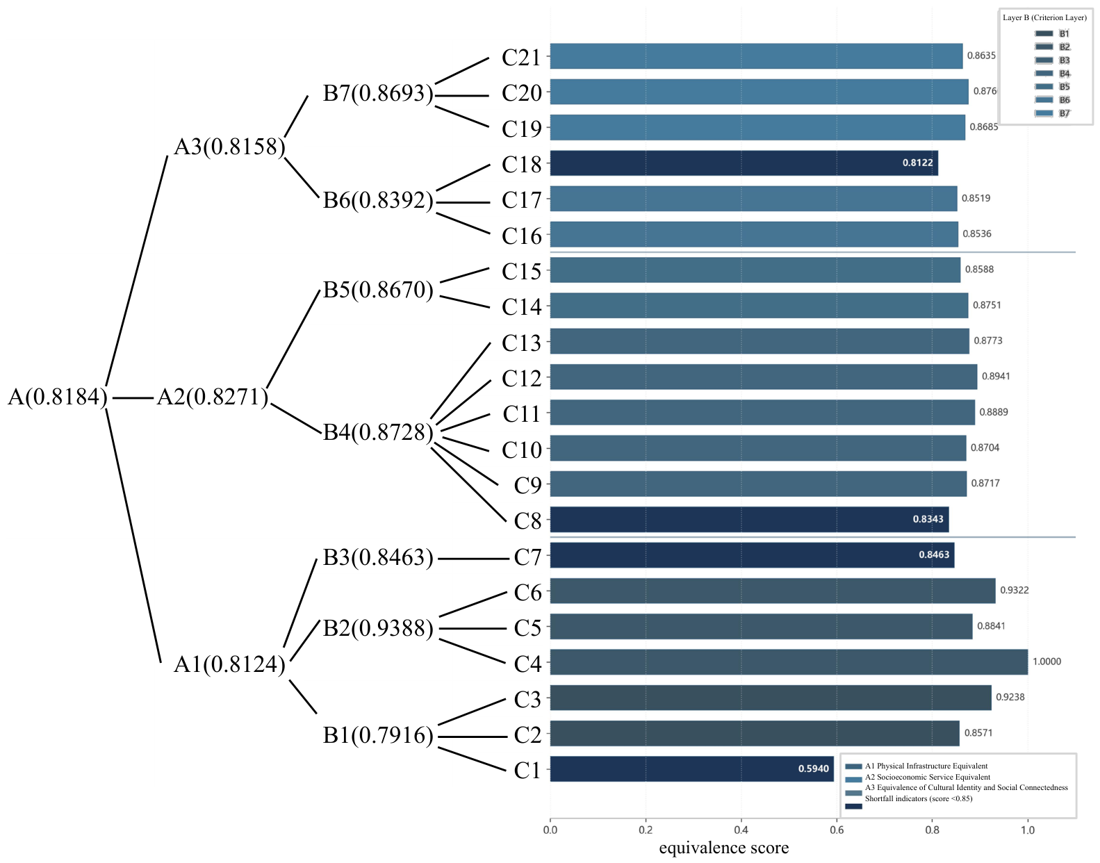
Based on the evaluation model established in Section 3, the calculation results show (Figure 5, Table 4) that the urban–rural equivalence index (UEI) of Xiapu County is 0.8184. According to the preset classification criteria (with 0.70–0.85 indicating moderate equivalence), the county as a whole is at a moderate equivalence level, with the value situated in the upper range of this interval. This study calculated the 95% confidence interval of the index using the Bootstrap method, and the result was [0.794, 0.842]. This suggests that Xiapu County has established a favorable development foundation for urban–rural integration and is generally close to the preset ideal reference state of equivalence. A more critical structural finding concerns the relationships among the three first-level dimensional indices. The physical infrastructure equivalence (A1) index is 0.8124, the socioeconomic service equivalence (A2) index is 0.8271, and the cultural identity and social connection equivalence (A3) index is 0.8158. All three indices fall within the moderate equivalence range, with minimal variation among them (the maximum difference is only 0.0147). This result challenges the simple linear assumption that “material foundation leads while socio-culture lags,” revealing that the urban–rural equivalence in Xiapu County is characterized by a notable pattern of initial synergy and coordinated advancement across the three dimensions of material foundation, institutional services, and socio-culture. The public service and institutional guarantee dimension (A2) shows a slight lead, suggesting relative success in the spatial layout of public service networks and perceived institutional fairness. The socio-cultural dimension (A3) does not lag significantly behind, implying that social integration has remained broadly synchronous with improvements in material and service conditions.
The indices for urban–rural equivalence in Xiapu County are concentrated in the range of 0.81–0.83. High scores indicate that the county is relatively close to the preset ideal state in multiple dimensions, but this does not mean that its development level has surpassed the basic national conditions or reached a developed stage. Rather, it reveals that, based on the existing foundation, the structural synergy of urban–rural relations is relatively good. Secondly, the qualitative conclusion of “moderate equivalence,” combined with the specific values of the comprehensive index, jointly demonstrates that Xiapu County’s urban–rural integration has moved beyond the general “basic gap-filling” stage and entered a new platform requiring optimization of the quality of “connection” and “synergy” mechanisms.
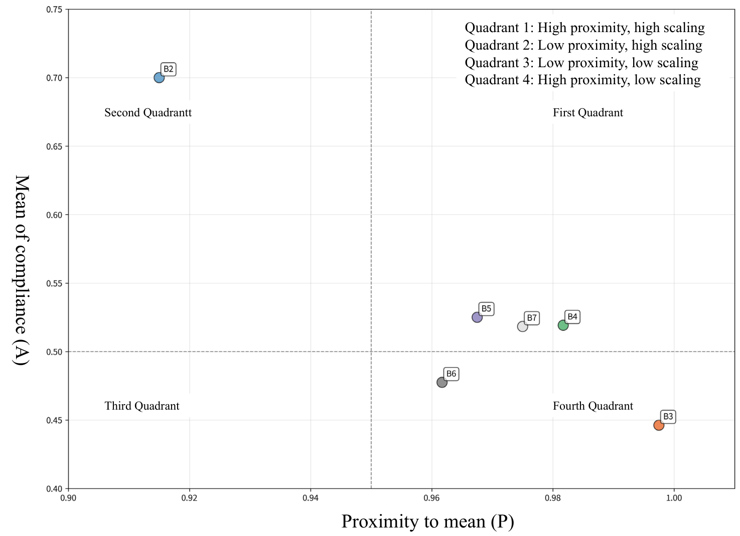
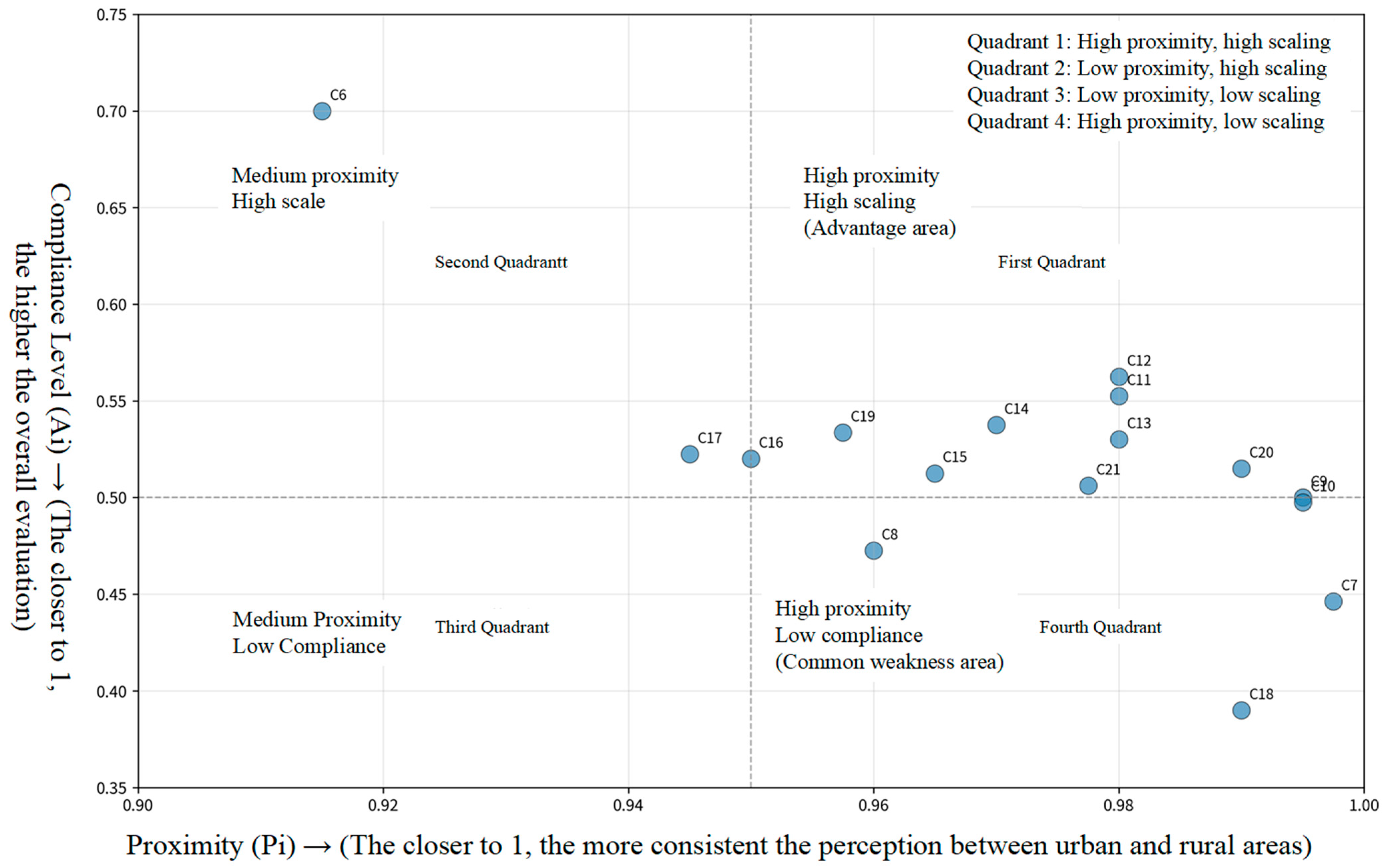
An analysis of the subjective perceptions of urban and rural residents in Xiapu County (Figure 6 and Figure 7) revealed that residents’ overall evaluations of ecological environment, infrastructure, and public services were mostly in the upper-middle range (2.54–3.97), indicating that a certain level of equivalence had been initially established between urban and rural areas. However, this convergence does not represent comprehensive and balanced development. Specifically, the urban–rural gap in ecological environment (B2) and social security system (B5) was relatively small and scored highly, while infrastructure (B3) and cultural identity (B6) were the main weaknesses. Particularly in infrastructure service level (C7), although the urban–rural similarity was extremely high (0.9975), the compliance rate was extremely low (0.4462), presenting a typical dilemma of “small gap but low overall level.” Meanwhile, participation in cultural activities (C18) scored the lowest among all indicators (0.3900), reflecting that the lack of public cultural life is a prominent problem faced by both urban and rural areas. In summary, current urban–rural equivalence is more about the convergence of basic conditions than high-quality development. Future planning strategies need to shift from simply “narrowing the urban–rural gap” to comprehensively improving the overall development level to address the practical challenge of “low-level equilibrium.”

4.2. In-Depth Problem Diagnosis from a Community Perspective

Although the composite index suggests that Xiapu County has established a relatively sound foundation for urban–rural equivalence, the community perspective requires us to move beyond static score comparisons and examine more deeply the dynamic process of “connection and integration.” Synthesizing the specific scores of individual indicators, residents’ perception data, and field investigations, this study finds that the bottlenecks constraining Xiapu County’s advancement toward a higher level of urban–rural equivalence, despite the superficially balanced triadic indices, have shifted from general “infrastructure gap-filling” to more deep-seated issues concerning the operational mechanisms of community.
First, from the perspective of territorial community, the core constraint lies in the “lack of efficiency” and “organizational weakening” of the spatial connectivity network. Although the skeleton of transport and municipal infrastructure has been largely established, residents’ perceived scores for transport accessibility convenience (C10) and infrastructure service levels (C7) still have room for improvement. Further field investigation reveals that the intensity of living connections between the county seat, central towns, and ordinary villages, especially between the county seat and some mountainous and island villages, is uneven. “Physical accessibility” in space has not been fully translated into high-frequency, convenient “daily connectivity.” These findings suggest a shift in the constraining factor from the “presence or absence” of facilities to the “quality” of the network. The key challenges now lie in optimizing the spatial organization of the county–town–village three-tier life circle, enhancing connectivity efficiency for factor flows and daily interactions, and strengthening the composite service and organizational functions of key nodes.
Second, from the perspective of governance community, the prominent contradiction manifests as “transmission blockage” and “insufficient coordination” in public services. Although the scores for perceived accessibility of public services (C8–C13) are acceptable, a more in-depth analysis reveals that residents’ evaluations of institutional fairness and trust (C14) are relatively low. Thus, the primary challenge has deepened from “spatial equity in service allocation” to “systemic coordination in service operation.” High-quality educational and medical resources at the county level experience efficiency losses during transmission to townships and villages. The reception capacity, professional level, and linkage mechanisms with higher-level institutions at grassroots service points (such as township health centers and cultural stations) have become weak links. A mature governance community requires more than “allocating in place.” It demands an efficiently coordinated “transmission–reception” mechanism that ensures services are “well received” and “effectively utilized.” Such a mechanism fosters solid institutional trust among residents.
Third, from the perspective of relational community, the key shortfall lies in the “insufficient momentum” and “lack of carriers” for social bonding. Although the baseline score for residents’ cultural identity and sense of belonging (C16) is not low, cultural activity participation (C18) and frequency of resident interactions (C21) are among the relatively lower-scoring indicators across the entire set. This suggests that the latent sense of identity between urban and rural residents has not been fully transformed into high-frequency, in-depth social interactions and public participation. Low vitality of community public spaces, a lack of carriers for neighborhood mutual assistance and cultural activities, and limited effective channels for public participation in communal affairs have led to the slow accumulation of social capital, leaving the relational community devoid of sustained endogenous momentum for growth. This represents the most difficult and central bottleneck in achieving the transition from “proximity in form” to “emotional cohesion.”

4.3. Summary of Stage Characteristics and Planning Strategies for Enhancing Urban–Rural Equivalence

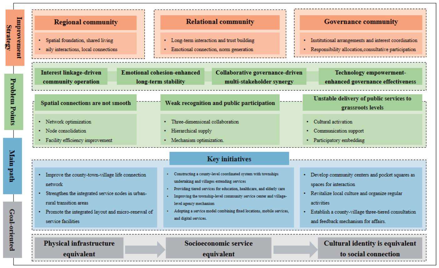
The empirical analysis of Xiapu County clearly delineates the stage characteristics of its urban–rural equivalence development: the county as a whole has moved beyond the stage of low-level equilibrium and entered a new development platform characterized by moderate equivalence and triadic synergy. At this stage, the primary contradiction driving the deepening of urban–rural integration has undergone a fundamental transformation. The marginal returns on large-scale facility gap-filling and resource input have diminished, whereas the organizational efficiency of spatial linkages, the coordinated governance capacity of public services, and the cultivation mechanisms for socio-cultural bonding have become the key variables influencing further improvement in urban–rural equivalence. This diagnostic finding carries important planning implications. It suggests that for Xiapu County and other counties at a similar development stage, future planning thinking and strategies must undergo a corresponding transition. The planning focus should shift from the “scale growth” paradigm, which emphasizes hardware investment and spatial coverage, toward a “quality improvement” paradigm that prioritizes optimizing network structures, refining governance chains, and activating social vitality. These strategies are elaborated as follows (Figure 8).
(1)
Promoting an efficiency revolution in the connectivity system from “tangible” to “effective”.
This response directly addresses the shortcomings of inefficient connectivity within “regional communities,” based on the discrepancies between indicators such as C7, C10, and C13, and on-site feedback. The core strategy is to promote the integration of transportation, logistics, and information networks to improve overall network efficiency. Specifically, while maintaining the accessibility of main transportation arteries, the focus should be on developing smart and flexible “responsive rural micro-buses” to dynamically connect remote residential areas with township hubs, solving the “last-mile” travel problem and directly improving the overall service experience represented by C7. Simultaneously, township transportation service stations and village-level convenience service points should be upgraded to integrated “passenger, freight, and mail” nodes, and a special action to “fill gaps and improve quality” of digital infrastructure should be implemented to ensure stable network signal coverage. By building a county-level smart living service platform, integrating travel, logistics, and public service information, and empowering physical flows with digital flow, a highly efficient, reliable, and intelligent composite urban–rural connectivity system can be constructed, laying a solid spatial foundation for the smooth flow and value exchange of all elements.
(2)
Deepen the coordinated reform of service supply and governance system.
This response aims to solve the problem of insufficient quality transmission and coordination faced by the “governance community”. It is based on the in-depth analysis of the C8–C15 series indicators, especially C11, C14 and C15. The key to the strategy is to innovate the mechanism to promote the sinking of high-quality public services and the formation of a multi-governance pattern. On the one hand, we should vigorously promote the group development model of “high-quality schools (hospitals) in county towns + branch schools (hospitals) in townships” and support it with the talent rotation and exchange system of “county management and school hiring, county management and township use”. This mechanism will ensure the orderly and sustainable flow of high-quality education resources and medical resources to townships and substantially improve the equalization of public services. On the other hand, we need to institutionalize the “urban–rural development co-governance committee” at the township level, include village cadres, resident representatives, local elites, social organizations, local enterprises and other diverse subjects in the consultation and decision-making process of public affairs, and use digital tools to realize the normalization of government affairs disclosure and opinion collection. By linking the management and maintenance responsibilities of small-scale public spaces and community environmental protection with community organizations, local governance forces are cultivated in practice, transforming institutional trust (C14) and resident participation (C15) into tangible governance effectiveness.
(3)
Launching a social and cultural identity and endogenous motivation cultivation project.
This response directly addresses the fundamental contradiction of insufficient cultural identity and endogenous motivation within the “community of relations,” and its basis comes directly from the performance of social and cultural dimension indicators such as C16, C17, and C18. The focus of the strategy is to nurture social capital and activate shared emotions through cultural co-cultivation and interest linkage. A systematic urban–rural “cultural co-cultivation” plan must be implemented, not limited to festival performances, and also deeply exploring, recording, and disseminating the county’s shared marine culture, immigrant history, and local skills, transforming them into content for community education and public art, and reshaping local cultural identity (C16) and shared memories. More importantly, the “community interest linkage” model should be prioritized and promoted in projects such as rural industrial development, rural tourism, and community building. This model allows local urban and rural residents to invest in the community through various means, including capital, land, and labor, forming an economic community with shared risks and benefits. This deep connection based on common economic interests and social cooperation (C19, C20, C21) can most effectively bridge the psychological barriers between urban and rural identities, cultivate a sense of shared belonging, and thus provide the strongest endogenous driving force for the sustainable development of urban–rural integration in counties.

5. Discussion

In the new stage of urban–rural relations transitioning from “coordinated development” to “deep integration,” how to accurately assess the level of urban–rural equivalence at the county level and, moving beyond superficial descriptions, reveal its underlying structural dynamics and constraints has become a focal point of both theoretical and practical concern. This study introduces a community perspective, constructing a triadic analytical framework of “territorial–governance–relational” communities and a corresponding comprehensive evaluation system. The central thesis of this study is that advancing urban–rural relations from “basic equivalence” to “high-quality integration” hinges critically on diagnosing and optimizing the internal mechanisms of “connection and integration” from a holistic community perspective, rather than merely continuing to close gaps on a single dimension.
The empirical results reveal a stage characterized by “moderate level, triadic synergy” in Xiapu County’s urban–rural equivalence. Such a finding transcends the simplistic narrative that privileges material factors over social ones or prioritizes the economy while neglecting culture. It suggests that at specific developmental junctures, urban–rural integration can manifest as a systemic and structural form of initial synergy. Hence, the understanding of county-level urban–rural equivalence must be deepened from static “disparity description” to dynamic “mechanism diagnosis.” The three primary contradictions in the Xiapu County case, namely, inefficient spatial connectivity, blocked public service transmission, and weak social bonding, converge on a core insight. Advanced urban–rural equivalence essentially results from the co-evolution and mutual reinforcement of the territorial, governance, and relational community subsystems. Therefore, the focus of planning intervention should shift from adding resources to a single dimension to optimizing the “connectivity” mechanisms within the system, i.e., enhancing the fluidity of network organization, the synergy of governance chains, and the regenerative capacity of social capital.
This study constructs a community evaluation framework based on “region–governance–relationships,” which attempts to find a critical path between two traditions: it opposes the excessive materialism, technocratization, and indicator-driven tendencies in traditional urban–rural evaluation systems, while also avoiding the boundless veneration of subjectivity, local narratives, and fragmentation from a purely postmodern perspective. This effort to integrate objective measurement with subjective perception, structural analysis with meaning interpretation, is not a simple compromise but rather is deeply aligned with the logic of “metamodernism,” a cutting-edge trend in contemporary human geography [43,44]. Metamodernism is understood as a way of thinking that oscillates between modernism (pursuing rationality, grand narratives, and universal truths) and postmodernism (emphasizing deconstruction, relativism, and local knowledge), attempting to transcend their binary opposition. It strives to provide a comprehensive platform integrating empirical, interpretive, material, symbolic, and practical knowledge to address the complex challenges of contemporary regional transformation. Urban–rural equivalence is not merely a static “target” represented by a comprehensive index but a dynamic and multi-layered spatial state that is constantly constructed, negotiated, and perceived within multiple geographical realities.
From a theoretical perspective, this study is an important supplement and deepening of the mainstream urban–rural “factor-structure” evaluation paradigm, achieving a paradigm shift from “gap comparison” to “relationship diagnosis.” Existing research on urban–rural integration or equivalence primarily follows the “factor–structure” analysis paradigm, focusing on measuring the allocation efficiency of quantifiable factors such as population, land, and capital, or the gaps in structural indicators such as economic output, infrastructure, and public service coverage. These studies answer the question of “how much difference” between urban and rural areas, essentially comparing development outcomes or static states. The “community” perspective introduced in this study shifts the analytical focus from “factors” and “structure” to “relationships” and “processes.” Our constructed three-dimensional framework of “region-governance-relationship” aims to diagnose whether and how a sustainable connection mechanism of “shared benefits, shared responsibilities, and emotional integration” has been formed between urban and rural areas. The value of this paradigm shift lies in its revelation that even if gaps in certain hardware indicators narrow, if social identity is weak and governance coordination fails, the relationship between urban and rural areas may still be a “fragile approach” or “passive integration,” rather than an “organic fusion.” This compensates for the shortcomings of traditional research in capturing the “social” and “process-oriented” dimensions of urban–rural relations, providing a more explanatory theoretical lens for understanding the deep mechanisms of urban–rural integration.
The primary theoretical contribution of this study lies in its successful operationalization of the relatively abstract sociological concept of “community” into a clearly structured and logically coherent triadic analytical framework of territorial, governance, and relational communities. The proposed framework transcends the limitation common in existing research of simply juxtaposing multiple dimensions without a theoretical core. It reveals the deep essence of urban–rural equivalence: the outcome of the mutual matching and co-evolution of three community subsystems, namely, territory (spatial carrier), governance (institutional operation), and relationality (socio-psychological bonding). The framework not only organically integrates material and non-material evaluative elements but also elucidates their progressive logic of “foundation–bridge–core,” thereby providing a powerful theoretical lens for understanding the complex connotations of urban–rural integration. At the methodological level, the contribution of this study lies in the construction and empirical validation of an evaluation instrument system oriented toward “mechanism diagnosis.” First, by setting reference values for urban–rural equivalence for objective indicators and performing standardized transformations on subjective perception data, the evaluation results directly reflect the “distance” between the current state and the ideal state, rather than a relative position within the sample. Second, by analyzing the distribution of low-scoring indicators across the three-dimensional framework (e.g., low participation in cultural activities corresponds to insufficient momentum in the relational community), this study achieves precise identification of the specific mechanisms constraining integration. Such an approach, which integrates objective statistical data with subjective perception data and focuses on explaining “why equivalence is not achieved,” enhances the explanatory power and practical relevance of the research.
The theoretical significance of this study lies in its advancement of urban–rural relations research from “factor comparison” toward “systemic relational analysis.” Its practical significance lies in providing a set of operational diagnostic tools and strategic response ideas for the county level. Nevertheless, several limitations point to future directions. First, the framework needs to be tested and refined at more micro-scales, such as townships and communities. Second, longitudinal follow-up studies are required to dynamically reveal the evolutionary pathways and dynamics of urban–rural communities. Third, comparative case studies in more diverse county types are needed to test and improve the generalizability of the framework and to develop a more typologically informed theory of urban–rural integration development.

6. Conclusions

As China’s urban–rural development enters a new stage oriented toward high-quality integration, urban–rural equivalence constitutes an important perspective for promoting county-level urban–rural integration. This study innovatively introduces community theory to construct a comprehensive evaluation framework for county-level urban–rural equivalence comprising three dimensions, namely, territorial, governance, and relational communities, and systematically tests this framework empirically using Xiapu County, Fujian Province, as a case study.
The results show that the composite urban–rural equivalence index of Xiapu County is 0.8184, which, according to the classification criteria, is judged as a “moderate equivalence” level. The structural characteristics are notable: the indices for physical infrastructure equivalence, socioeconomic service equivalence, and cultural identity and social connection equivalence are 0.8124, 0.8271, and 0.8158, respectively, exhibiting a pattern of close proximity and synergistic development. Such a “moderately balanced” structure indicates that urban–rural integration in the county has moved beyond the stage of basic gap-filling and entered a new platform requiring systematic enhancement. The evaluation further identifies the key mechanistic obstacles constraining advancement to a higher level, which are concentrated in the efficiency of spatial connectivity networks, the grassroots-level coordination capacity of public services, and the endogenous momentum for cultivating social capital.
The value of this study lies in providing not only an operational method integrating subjective and objective data for the scientific assessment of county-level urban–rural equivalence but also, more importantly, in offering a “mechanism diagnosis” perspective and a “system empowerment” strategic approach, which together provide a useful theoretical reference and practical guidance for advancing county-level urban–rural relations from “proximity in form” toward “substantive integration” in the new era.

Supplementary Materials

The following supporting information can be downloaded at: https://www.mdpi.com/article/10.3390/su18105153/s1.

Author Contributions

Q.S.: conceptualization, methodology design, software development, data processing, drafting, and visualization; manuscript review and revision. Y.C.: conceptualization, methodology design, software development, data processing, drafting, and visualization. M.Y.: conceptualization, methodology design, manuscript review, and visualization; data processing. All authors have read and agreed to the published version of the manuscript.

Funding

Major Project Funding for Social Science Research Base in Fujian Province (FJ2024JDZ055), Natural Science Foundation of Fujian Province (2025J08224), Fujian Provincial Natural Resources Science and Technology Innovation Project (KY-030000-04-2025-045).

Institutional Review Board Statement

Ethical review and approval were waived for this study by Institution Committee as Article 32 of the “Measures for Ethical Review of Life Science and Medical Research Involving Human Subjects” (National Health and Family Planning Commission Document No. 4 [2023]).

Informed Consent Statement

Informed consent was obtained from all subjects involved in the study.

Data Availability Statement

The datasets used and/or analyzed during the current study available from the corresponding author on reasonable request.

Conflicts of Interest

The authors declare no conflicts of interest.

References

  1. CPC Central Committee and State Council. Opinions of the CPC Central Committee and the State Council on Establishing and Improving the Institutional Mechanisms and Policy System for Integrated Urban-Rural Development. People’s Daily, 6 May 2019; p. 1.
  2. Zhang, Z.; Yuan, G.; Liu, R. Natural resource factors promoting urban and rural integrated development in the new era: Target selection and policy design. Bull. Chin. Acad. Sci. 2024, 39, 1401–1409. [Google Scholar] [CrossRef]
  3. Zhou, Z.; Yao, L. Value implications and pathways for leading the breakthrough of the urban-rural dual structure at the county level. Res. Agric. Mod. 2025, 46, 1–11. [Google Scholar] [CrossRef]
  4. Su, Q.; Chang, H.-S. Innovating Urban and Rural Planning Education for Climate Change Response: A Case of Taiwan’s Climate Change Adaptation Education and Teaching Alliance Program. Sustainability 2026, 18, 886. [Google Scholar] [CrossRef]
  5. Su, Q.; Min, Y. Stormwater Runoff Allocation and Basin-Wide Flood Mitigation Mechanism From the Perspectives of Efficiency and Equity. Landsc. Archit. Front. 2025, 13, 109. [Google Scholar]
  6. Wang, X.; Chen, J.; Zhang, B.; He, A. Coordinating new urbanization and comprehensive rural revitalization: Theoretical logic, realistic challenges, and practical paths. Res. Agric. Mod. 2025, 46, 22–32. [Google Scholar] [CrossRef]
  7. Ye, X.; Lei, C.; Fan, L. The development path of New County Urbanization in the Chinese-style modernization. China Anc. City 2024, 38, 9–15. [Google Scholar] [CrossRef]
  8. Tao, D.K.; Yang, C.; Lu, Q.; Wang, X. The development path of New Urbanization in County-level Units under the background of territorial planning. City Plan. Rev. 2022, 46, 25–36+76. [Google Scholar]
  9. Zhou, D.; Qi, J.L.; Zhong, W.Y. Review of urban-rural integration evaluation: Connotation identification, theoretical analysis, and system reconstruction. J. Nat. Resour. 2021, 36, 2634–2651. [Google Scholar] [CrossRef]
  10. Cui, S.Q.; Zhou, G.H.; Dai, L.Y.; Wu, G.H.; He, Y.H. The research progress and prospects of Urban-Rural Integrated Development based on geographical perspective. Econ. Geogr. 2022, 42, 104–113. [Google Scholar] [CrossRef]
  11. Lu, Y.; Chen, H. Rural cultural revitalization and community reconstruction: A case study of Zhuji City, Zhejiang Province. J. Tsinghua Univ. (Philos. Soc. Sci.) 2022, 37, 205–214+220. [Google Scholar] [CrossRef]
  12. Gong, W.; Ma, S. Research progress and prospects of Urban-Rural Integration based on scientific knowledge map. Trop. Geogr. 2025, 45, 776–791. [Google Scholar] [CrossRef]
  13. Kishune, T. National Land Planning Toward the 21st Century: Design of an Urban-Rural Integration System; Gao, W., Translator; Science Press: Beijing, China, 1990. [Google Scholar]
  14. Wang, Y. The spatial co-construction mechanism and element-driven pathways of the “urban-rural equivalence” concept: An empirical analysis of Hangzhou’s “networked metropolis”. Urban Insight 2025, 114–127+163. [Google Scholar]
  15. Liu, M.K.; Deng, X.G.; Ren, L.L.; Liang, L.J. Theoretical logic and mechanisms of tourism-driven rural governance from the perspective of urban-rural equivalence. J. Cent. China Norm. Univ. (Nat. Sci.) 2024, 58, 94–102. [Google Scholar] [CrossRef]
  16. Aristotle. Politics; Wu, S., Translator; The Commercial Press: Beijing, China, 1965; pp. 339–353. [Google Scholar]
  17. Zhou, J.; Qin, F.; Liu, J.; Zhu, G.; Zou, W. Measurement, spatial-temporal evolution and influencing mechanism of urban-rural integration level in China from a multidimensional perspective. China Popul. Resour. Environ. 2019, 29, 166–176. [Google Scholar]
  18. Xiong, Y.; Dai, Y. Digital economy and integrated urban-rural development: Theoretical mechanism and empirical test. J. Arid Land Resour. Environ. 2024, 38, 1–10. [Google Scholar] [CrossRef]
  19. Xie, Z.; Zhen, F. Measuring urban-rural integration level in Nanjing based on multi-source data. Sci. Geogr. Sin. 2023, 43, 1–10. [Google Scholar] [CrossRef]
  20. Zhang, Q.; Yang, Z.; Zhang, Z.; Guo, X.; Feng, W.; Wang, L. Key characteristics and evaluation index of county urban-rural integration in the new stage of development: Based on data from 5 sample counties. Chin. J. Agric. Resour. Reg. Plan. 2023, 44, 181–189. [Google Scholar]
  21. Yang, C.; Zheng, C. Research on the Spatial-temporal Characteristics and Influencing Factors of Urban-rural Integration in Mountainous Counties of Zhejiang Province. Dev. Small Cities Towns 2024, 42, 5–13. [Google Scholar]
  22. Lu, Y.; Zhuang, J.; Yang, C.; Li, L.; Kong, M. How the digital economy promotes urban–rural integration through optimizing factor allocation: Theoretical mechanisms and evidence from China. Front. Sustain. Food Syst. 2025, 9, 1494247. [Google Scholar] [CrossRef]
  23. Luo, B. On urban-rural integrated development with Chinese characteristics at the county level: An analytical paradigm of “institution-space-governance”. J. Nanjing Agric. Univ. (Soc. Sci.) 2025, 25, 14–31. [Google Scholar] [CrossRef]
  24. Ding, Y.; Wu, L. What influences the perception of fairness in urban and rural China? An analysis using machine learning. Humanit. Soc. Sci. Commun. 2025, 12, 1–14. [Google Scholar] [CrossRef]
  25. Xu, L.; Chen, X.; Han, Y.; Li, F. The difference in social welfare between urban and rural areas and the reform of the household registration system: Evidence based on the satisfaction of Chinese residents. Cogent Soc. Sci. 2025, 11, 2567517. [Google Scholar] [CrossRef]
  26. Guo, J.; Zheng, Y. The impact of new urbanization pilot policy on the equalization of basic public services: An empirical analysis based on panel data from 2489 counties in China. East China Econ. Manag. 2025, 39, 82–94. [Google Scholar] [CrossRef]
  27. Tong, W.; Jiang, Y.; Guo, J.; Zheng, J. Impact of urban-rural factor integration on common prosperity of county in Zhejiang Province. Geogr. Sci. 2025, 45, 1431–1441. [Google Scholar] [CrossRef]
  28. Mei, D.; Wang, Y.; Wang, X. Measurement of the level of urban-rural integration development in the Yimeng Mountainous area and its spatiotemporal pattern research. J. Northwest Norm. Univ. (Nat. Sci.) 2025, 61, 70–80. [Google Scholar] [CrossRef]
  29. Bovaird, T. Beyond engagement and participation: User and community coproduction of public services. Public Adm. Rev. 2007, 67, 846–860. [Google Scholar] [CrossRef]
  30. Alford, J. The multiple facets of co-production: Building on the work of Elinor Ostrom. Public Manag. Rev. 2014, 16, 299–316. [Google Scholar] [CrossRef]
  31. Osborne, S.P. From public service-dominant logic to public service logic: Are public service organizations capable of co-production and value co-creation? Public Manag. Rev. 2018, 20, 225–231. [Google Scholar] [CrossRef]
  32. Wang, D.; Li, S. Innovation of contemporary Chinese urban community governance under the perspective of social capital: Participation of multiple subjects based on community proposals. Sustainability 2022, 15, 93. [Google Scholar] [CrossRef]
  33. Wen, J. The Governance Community of Megacities and Its Construction: From the Perspective of Service-Oriented Governance. Guangming Daily, 13 November 2024.
  34. Shi, S.; Zhang, X. Digital technology-driven construction of community environmental governance communities: Practical dilemmas, internal logic, and path choices. Trib. Study 2024, 39–50. [Google Scholar] [CrossRef]
  35. Shuo, W.; Tao, S. Transportation infrastructure, labor allocation and the urban-rural integrated development in China: From the perspective of dual coupling of labor force with the industry and the region. J. Guangdong Univ. Financ. Econ. 2023, 38, 98–112. [Google Scholar] [CrossRef]
  36. Tonnies, F. Community and Society; Lin, R., Translator; The Commercial Press: Beijing, China, 2019; pp. 1–72. [Google Scholar]
  37. Liu, P.; Han, A.; Yuan, Y. Community Leadership and Its Contribution to Rural Revitalization Under the Context of Population Hollowing-Out: Evidence From Shanghai, China. Popul. Space Place 2025, 31, e2880. [Google Scholar] [CrossRef]
  38. Wang, Z. The reconfiguration of publicness and the formation of rural governance communities: A study on the practice of Rural Revitalization empowerment based on Village Super League. Soc. Constr. 2025, 12, 76–106. [Google Scholar] [CrossRef]
  39. Chen, R.; Che, Y. Interest aggregation and action synergy: How to construct rural governance community in the new era. Chin. Public Adm. 2022, 65–73. [Google Scholar] [CrossRef]
  40. He, M.; Jian, J. The construction logic and practical paths of rural governance communities. J. Univ. Jinan 2026, 36, 123–132. [Google Scholar] [CrossRef]
  41. Zang, L.; Sun, J. Rural subjectivity and its impact on rural regional system in Yangshuo county, Guangxi. Acta Geogr. Sin. 2025, 80, 453–474. [Google Scholar]
  42. Han, B.; Lu, X.; Zhang, J. An exploratory study on international experience and local application of integrated development of urban and rural areas: With a concurrent discussion on the concept of Urban-Rural Equalized Development. Urban Plan. Int. 2025, 40, 83–92. [Google Scholar] [CrossRef]
  43. Matlovič, R.; Matlovičová, K. The metamodern shift in geographical thought: Oscillatory ontology and epistemology, post-disciplinary and post-paradigmatic perspectives. Folia Geogr. 2025, 67, 22. [Google Scholar]
  44. Storm, J.A.J. Metamodernism: The Future of Theory; University of Chicago Press: Chicago, IL, USA, 2021. [Google Scholar]
  45. Sharifi, A.; Sobhaninia, S.; Esfandi, S.; Amirzadeh, M.; Tayebi, S.; Cheshmehzangi, A. Co-benefits and trade-offs of urban resilience for sustainable development goals (SDGs). Habitat Int. 2026, 170, 103735. [Google Scholar] [CrossRef]
  46. Wang, S.; Zhou, J.; Liang, H.; Zhou, L.; Wang, Z.; Zhao, S.; Wang, H. Optimization of urban service facility allocation for the SDGs: Current status, innovations, and prospects. Sustain. Cities Soc. 2026, 142, 107291. [Google Scholar] [CrossRef]
  47. Liu, L.; Zhang, J.; Wang, T.; Wang, Y. Study on the evaluation and realization path of urban—Rural integration in Sichuan Province. Environ. Sustain. Indic. 2025, 28, 101021. [Google Scholar] [CrossRef]
  48. Liu, M.; Li, Q.; Bai, Y.; Fang, C. A novel framework to evaluate urban-rural coordinated development: A case study in Shanxi Province, China. Habitat Int. 2024, 144, 103013. [Google Scholar] [CrossRef]
  49. Zhong, S.; Zuo, J.; Huang, X. Assessing county-level urban–rural integrated development in China from a coupling perspective, 2001–2020. Appl. Geogr. 2026, 190, 103985. [Google Scholar] [CrossRef]
  50. Eric, M.; Kathryn, E.; Shwetha, G. World Bank Country Classifications by Income Level for 2024–2025. Data Blog, 1 July 2024.
Figure 1. Conceptual diagram of community.
Sustainability 18 05153 g001
Figure 2. Refinement and reconstruction of community theory.
Sustainability 18 05153 g002
Figure 3. A triadic analytical framework for county-level urban–rural equivalence from a community perspective.
Sustainability 18 05153 g003
Figure 4. Study area.
Sustainability 18 05153 g004
Figure 5. Equivalence scores of individual indicators.
Sustainability 18 05153 g005
Figure 6. Criterion layer proximity–compliance analysis chart.
Sustainability 18 05153 g006
Figure 7. Analysis of the proximity and compliance rates of resident questionnaire indicators.
Sustainability 18 05153 g007
Figure 8. Framework diagram of strategies for enhancing urban–rural equivalence in Xiapu.
Sustainability 18 05153 g008
Table 2. Reliability test of the criterion layer of the indicator system.
Criterion LayerCriterion Layer NameCorresponding Indicator NumberReliability Testing MethodsReliability Coefficient
B2Spatial land use and ecological foundationC6Cronbach’s α0.786
B3Infrastructure configurationC7--
B4Accessibility and sense of gain of public servicesC8–C13Cronbach’s α0.881
B5Institutional guarantees and sense of trustC14–C15Spearman-Brown0.778
B6Cultural identity and belongingC16–C18Cronbach’s α0.781
B7Social relations and cooperationC19–C21Cronbach’s α0.848
Table 3. Criteria for classifying urban–rural equivalence levels.
Composite Index RangeEquivalence LevelExplanation
0.85–1.00High EquivalenceMost indicators are close to or have reached the reference standard, and overall are close to the preset urban–rural equivalence state.
0.70–0.85Moderate EquivalenceA solid foundation for equivalence has been established, but some dimensions still show certain gaps.
0.50–0.70Low EquivalenceSeveral fields have a certain foundation, but there remains an evident gap from the preset equivalence state overall.
<0.50Insufficient EquivalenceMultiple dimensions have not yet met the reference standard, and the overall degree of equivalence remains relatively low.
Table 4. Analysis of urban–rural equivalence measurement results in Xiapu County.
Target Layer (A) and Composite IndexCriterion Layer (B)Corresponding Indicator (C)Reference ValuesIndicator Score (Sj)Indicator Weight (wi)Urban/Rural Sample Mean (Urban/Rural)Standard Deviation (Combined)Urban–Rural Difference t-Test (p-Value)Barrier Degree (%)Ranking
A1
I1 = 0.8124
B1 C1 13.00.5940.11013.2/7.1--4.475
C2 1.50.8570.0531.73--0.7615
C3 85.00.9240.03778.5%--0.2820
B2 C4 0.24–0.361.0000.0430.32--0.0021
C5 75.00.8840.03366.3%--0.3819
C6 4.00.9320.0683.63/3.970.890.1120.4618
B3 C7 4.00.8460.0682.79/2.780.950.9911.0412
A2
I2 = 0.8271
B4 C8 4.00.8340.0642.97/2.811.020.045 1.1311
C9 4.00.8720.0513.01/2.990.980.8730.6716
C10 4.00.8700.0443.00/2.980.910.9050.5717
C114.00.8890.0363.25/3.170.870.3200.4021
C124.00.8940.0313.29/3.210.840.4050.3322
C134.00.8770.0293.16/3.080.930.4880.3623
B5 C144.00.8750.0583.09/3.210.960.2140.7314
C154.00.8590.0392.98/3.121.050.038 0.5517
A3
I3 = 0.8158
B6 C164.00.8540.0523.18/2.981.100.008 0.7615
C174.00.8520.0363.20/2.981.080.005 0.5318
C184.00.8120.0272.58/2.541.120.8120.5119
B7 C194.00.8680.0533.22/3.050.990.021 0.7013
C204.00.8760.0393.04/3.080.940.7650.4820
C214.00.8640.0293.07/2.981.010.4120.4024
Urban–Rural Equivalence Index (UEI) 0.8184
Disclaimer/Publisher’s Note: The statements, opinions and data contained in all publications are solely those of the individual author(s) and contributor(s) and not of MDPI and/or the editor(s). MDPI and/or the editor(s) disclaim responsibility for any injury to people or property resulting from any ideas, methods, instructions or products referred to in the content.