Mountain Meadows and Glades of the Carpathians—Type or Element of Landscape? The Problem of Delimitation and Typology of Mountain Pasture Landscapes


Abstract
1. Introduction
- A set of material objects with a specific content (i.e., physical, chemical and biological composition) and form (landform and texture, and in the case of anthropogenic elements—also with a specific composition).
- A system of related processes integrating material objects.
- A set of stimuli that affect the various senses of the user, particularly a set of views and panoramas with specific aesthetic value.
- A set of natural, social, economic, material, spiritual, historical, physiognomic, aesthetic, symbolic and other values (potentials).
- A system that provides real and potential services (benefits) for different groups of users.
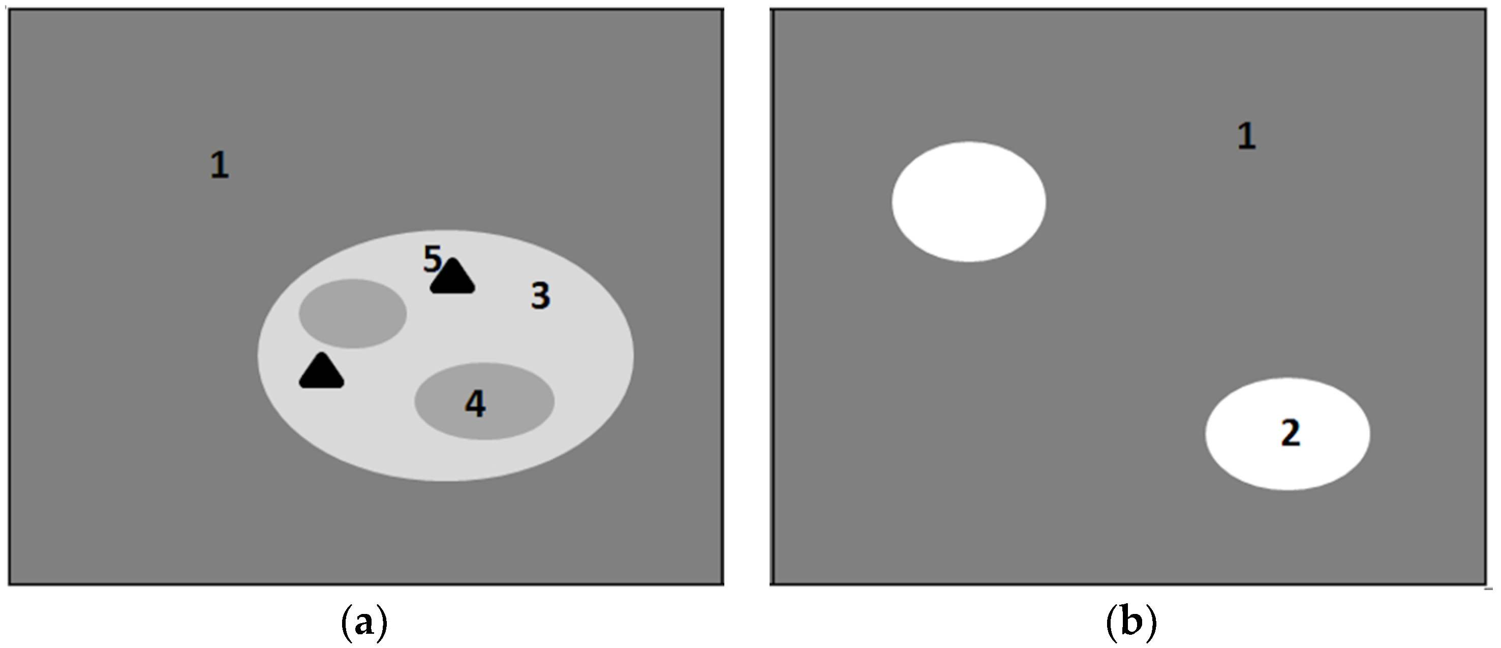
- Homogeneity of the landscape background while maintaining spatial heterogeneity.
- Preservation of functional connections between spatial elements of the landscape.
- Repeatability of spatial structure and physiognomy in different parts of the landscape (this condition may not always be preserved, especially in the case of unique landscapes).
2. Materials and Methods
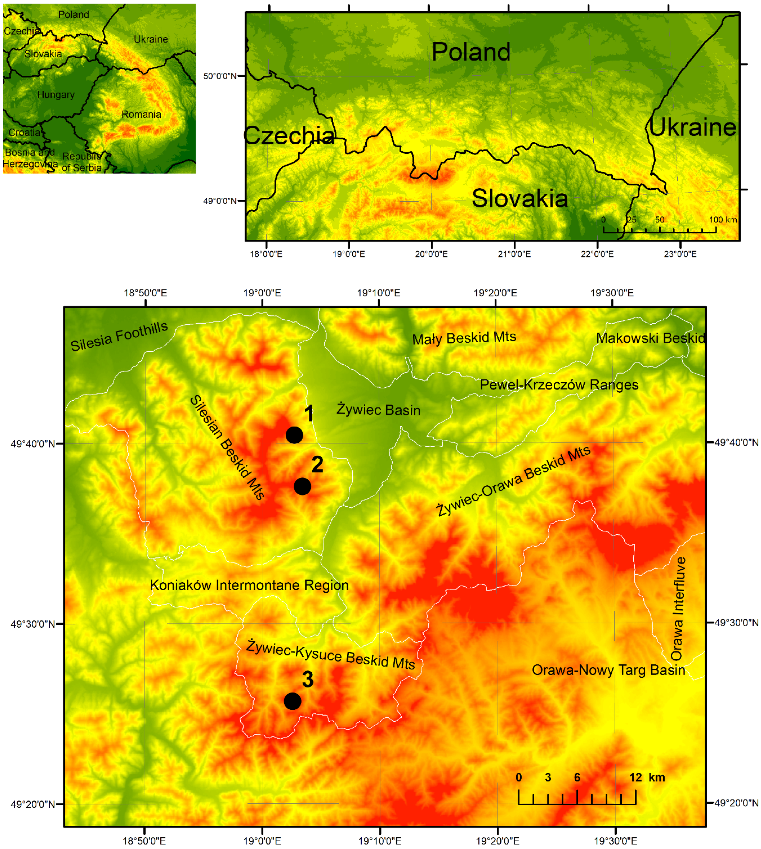
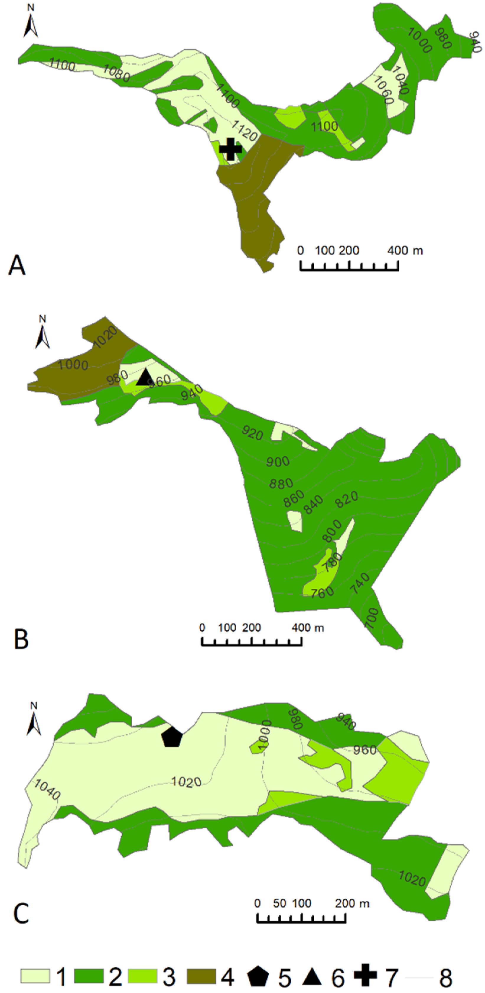
2.1. Study Area
2.2. Analysis of Objective Nature of Landscape
2.3. Analysis of Subjective Nature of Landscape
3. Results
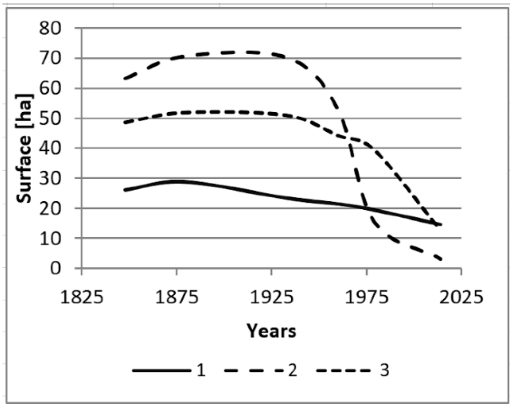
3.1. State and Changes of Pasture Landscape
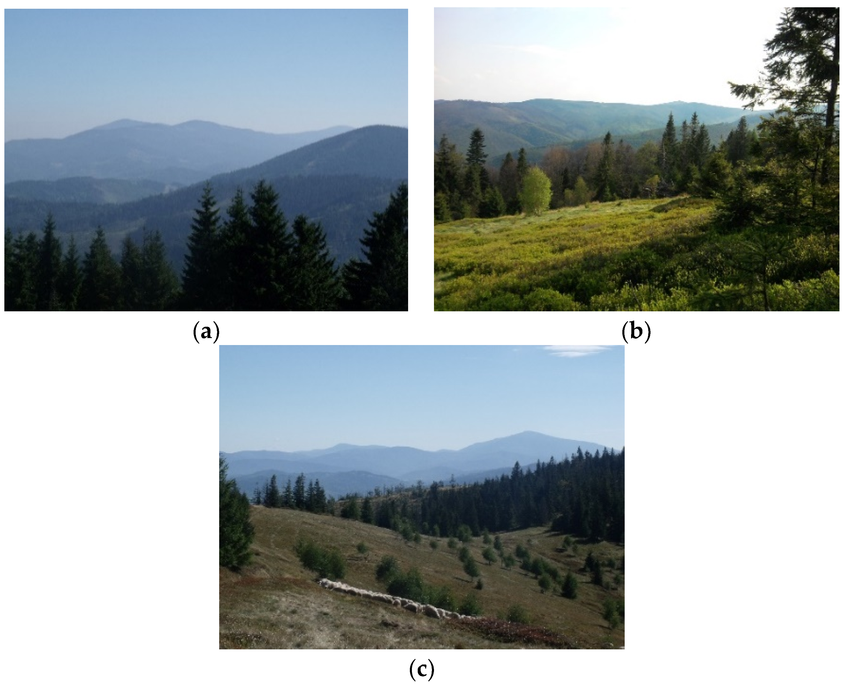
3.2. Pasture Landscape Values and Services
- Providing food (e.g., meat, milk, cheese, blueberries, herbs) and materials (e.g., fodder).
- Regulation and maintenance, e.g., soil stabilization, water circulation regulation, microclimate regulation.
- Cultural (interaction with nature), e.g., tourism, education, shaping regional identity.
4. Discussion
- Refer to landscapes distinguished as spatial units with specific boundaries and sizes.
- Refer to contemporary landscapes.
- Take into account directly the diversity, surface share and spatial layout (texture and composition) of real objects in space.
5. Conclusions
Funding
Acknowledgments
Conflicts of Interest
References
- Sharma, L.M.; Vetaas, O.R.; Chaudhary, R.P.; Måren, I.E. Pastoral Abandonment, Shrub Proliferation and Landscape Changes: A Case Study from Gorkha, Nepal. Landsc. Res. 2014, 39, 53–69. [Google Scholar] [CrossRef]
- Myga-Piątek, U. Cultural Landscape. Evolutionary and Typological Aspects, 1st ed.; UŚ: Katowice, Poland, 2012; pp. 1–404. [Google Scholar]
- Falkowski, J.; Kostrowicki, J. Geography of Agriculture in the World, 1st ed.; PWN: Warszawa, Poland, 2001; pp. 1–516. [Google Scholar]
- Kemery, B. Yurts Living in the Round, 1st ed.; Gibbs Smith Publisher: Layton, UK, 2006; pp. 1–146. [Google Scholar]
- Sobala, M. Pasture landscapes in Poland and Europe—Selected types, examples and conservation methods. Diss. Cult. Landsc. Commis. 2014, 25, 81–98. [Google Scholar]
- Rahimon, R.M. Evolution of Land Use in Pastoral Culture in Central Asia with Special Reference to Kyrgyzstan and Kazakhstan. In Rangeland Stewardship in Central Asia Balancing Improved Livelihoods, Biodiversity Conservation and Land Protection, 1st ed.; Squires, V., Ed.; Springer: Berlin/Heidelberg, Germany, 2012; pp. 51–70. [Google Scholar]
- Săvulescu, I.; Mihai, B.A.; Vîrghileanu, M.; Nistor, C.; Olariu, B. Mountain Arable Land Abandonment (1968–2018) in the Romanian Carpathians: Environmental Conflicts and Sustainability Issues. Sustainability 2019, 11, 6679. [Google Scholar] [CrossRef]
- Yu, Z.; Liu, L.; Zhang, H.; Liang, J. Exploring the Factors Driving Seasonal Farmland Abandonment: A Case Study at the Regional Level in Hunan Province, Central China. Sustainability 2017, 9, 187. [Google Scholar] [CrossRef]
- Krauß, W.; Olwig, K.R. Special issue on pastoral landscapes caught between abandonment, rewilding and agro-environmental management. Is there an alternative future? Landsc. Res. 2018, 43, 1015–1020. [Google Scholar] [CrossRef]
- Blench, R.; Sommer, F. Understanding rangeland biodiversity. Work. Pap. 1999, 121, 1–51. [Google Scholar]
- Costanza, R.; d’Arge, R.; de Groot, R.; Farber, S.; Grasso, M.; Hannon, B.; Limburg, K.; Naeem, S.; O’Neill, R.V.; Paruelo, J.; et al. The value of the world’s ecosystem services and natural capital. Nature 1997, 387, 253–260. [Google Scholar] [CrossRef]
- Olwig, K.R. Virtual enclosure, ecosystem services, landscape’s character and the ‘rewilding’ of the commons: The “Lake District” case. Landsc. Res. 2016, 41, 253–264. [Google Scholar] [CrossRef]
- Pachoud, C.; Da Re, R.; Ramanzin, M.; Bovolenta, S.; Gianelle, D.; Sturaro, E. Tourists and Local Stakeholders’ Perception of Ecosystem Services Provided by Summer Farms in the Eastern Italian Alps. Sustainability 2020, 12, 1095. [Google Scholar] [CrossRef]
- Kreutzmann, H. Pastoralism in Central Asian Mountain Regions. In Pastoralism and Rangeland Management in Mountain Areas in the Context of Climate and Global Change, 1st ed.; Kreutzmann, H., Abdulalishoev, K., Zhaohui, L., Richter, J., Eds.; GIZ BMZ: Bonn, Germany, 2011; pp. 38–63. [Google Scholar]
- Sotherton, S.W. Land use changes and the decline of farmland wildlife: An appraisal of the set-aside approach. Biol. Conserv. 1998, 83, 259–268. [Google Scholar] [CrossRef]
- Riecken, U.; Finck, U.; Schroder, E. Significance of pasture landscape for nature conservation and extensive agriculture. In Pasture landscape and Nature Conservation, 1st ed.; Redecker, B., Finck, P., Hardtle, W., Riecken, U., Schroder, E., Eds.; Springer: Berlin/Heidelberg, Germany, 2002; pp. 423–435. [Google Scholar]
- Didier, L. Invasion patterns of European larch and Swiss stone pine in subalpine pastures in the French Alps. For. Ecol. Manag. 2001, 145, 67–77. [Google Scholar] [CrossRef]
- Gehrig-Fasel, J.; Guisan, A.; Zimmermann, N.E. Tree line shifts in the Swiss Alps: Climate change or land abandonment. J. Veg. Sci. 2007, 18, 571–582. [Google Scholar] [CrossRef]
- Gellrich, M.; Baur, P.; Koch, B.; Zimmermann, N.E. Agricultural land abandonment and natural forest re-growth in the Swiss mountains: A spatially explicit economic analysis. Agric. Ecosyst. Environ. 2007, 118, 93–108. [Google Scholar] [CrossRef]
- Tasser, E.; Walder, J.; Tappeneiner, U.; Teutsch, A.; Noggler, W. Land-use changes and natural reforestation in the Eastern Central Alps. Agric. Ecosyst. Environ. 2007, 118, 115–129. [Google Scholar] [CrossRef]
- Haller, A.; Bender, O. Among rewilding mountains: Grassland conservation and abandoned settlements in the Northern Apennines. Landsc. Res. 2018, 43, 1068–1084. [Google Scholar] [CrossRef]
- Seidl, N.P.; Golobič, M. The effects of EU policies on preserving cultural landscape in the Alps. Landsc. Res. 2018, 43, 1085–1096. [Google Scholar] [CrossRef]
- Aide, T.M.; Zimmerman, J.K.; Pascarella, J.B.; Luis, R.; Marcano-Vega, H. Forest regeneration in a chronosequence of tropical abandoned pastures: Implication for restoration ecology. Restor. Ecol. 2000, 8, 328–338. [Google Scholar] [CrossRef]
- Rahmonov, O.; Rahmonov, M.; Opała-Owczarek, M.; Owczarek, P.; Niedźwiedź, T.; Myga-Piątek, U. Ecological and cultural importance of juniper ecosystem in the area of Zeravshan valley (Tajikistan) on the background of environmental condition and anthropogenic hazards. Geograph. Polon. 2017, 90, 441–461. [Google Scholar] [CrossRef]
- Negi, C.S. Declining transhumance and subtle changes in livelihood patterns and biodiversity in the Kumaon Himalaya. Mount. Res. Develop. 2007, 27, 114–118. [Google Scholar] [CrossRef][Green Version]
- Krauß, W. Alpine landscapes in the Anthropocene: Alternative common futures. Landsc. Res. 2018, 43, 1021–1031. [Google Scholar] [CrossRef]
- European Landscape Convention. Available online: https://rm.coe.int/1680080621 (accessed on 25 March 2020).
- Landscape Atlas of the Czech Republic. Available online: https://www.mzp.cz/cz/atlas_krajiny_cr (accessed on 25 March 2020).
- Landscape Character Assessment Guidance for England and Scotland. Available online: http://publications.naturalengland.org.uk/file/2672917 (accessed on 25 March 2020).
- Landscape atlas of Slovak Republic. Available online: https://geo.enviroportal.sk/atlassr/ (accessed on 25 March 2020).
- Nogué, J.; Sala, P. Prototype Landscape Catalogue. Conceptual, Methodological and Procedural Bases for the Preparation of the Catalan Landscape Catalogues. Summary, 1st ed.; Observatori del Paisatge: Barcelona, Spain, 2006; pp. 1–31. [Google Scholar]
- Veteikis, D.; Jankauskaite, M. Territorial regionalization of landscape technosphere in Lithuania. J. Environ. Eng. Landsc. Manag. 2009, 17, 60–67. [Google Scholar] [CrossRef]
- Gharadjedaghi, B.; Heimann, R.; Lenz, K.; Martin, C.; Pieper, V.; Schulz, A.; Vahabzeadah, A.; Finck, P.; Riecken, U. Verbreitung und Gefährdung schutzwürdiger Landschaften in Deutschland. Natur und Landsch. 2004, 79, 71–81. [Google Scholar]
- Fink, M.H.; Grünweis, F.M.; and Wrbka, T.H. Kartierung ausgewählter Kulturlandschaften Österreichs, 1st ed.; Monographien des Umweltbundesamtes: Wien, Austria, 1989; pp. 1–335. [Google Scholar]
- Walder, B.S.; Glamm, A. Swiss Landscape Concept; Swiss Agency for Environment, Forests and Landscape: Berne, Switzerland, 1998; pp. 1–64. [Google Scholar]
- Pinto-Correia, T.; Canela d’Abreu, A.; Oliveira, R. Landscape evaluation: Methodological considerations and application within the Portuguese 145 national landscape assessment. Adv. Ecol. Sci. 2004, 14, 235–252. [Google Scholar]
- Mata Olmo, R.; Sanz Herraiz, C. Atlas de los Paisajes de España. Ministerio de Medio Ambiente de España; Ministerio de Agricultura y Pesca: Madrid, Spain, 2003; pp. 1–683.
- Milanova, E.V.; Kushlin, A.V. World Map of Present-Day Landscapes. An Explanatory Guide; Moscow State University, in collaboration with UNEP: Moscow, Russia, 2003; pp. 1–25. [Google Scholar]
- Meeus, J.H.A. Pan-European landscapes. Landsc. Urban Plan. 1995, 31, 57–79. [Google Scholar] [CrossRef]
- Mücher, C.A.; Klijn, J.A.; Wascher, D.M.; Schaminée, J.H.J. A new European Landscape Classification (LANMAP): A transparent, flexible and user-oriented methodology to distinguish landscapes. Ecol. Indic. 2010, 10, 87–103. [Google Scholar] [CrossRef]
- Van der Zanden, E.H.; Levers, C.; Verbung, P.H.; Kuemmerle, T. Representing composition, spatial structure and management intensity of European agricultural landscapes: A new typology. Landsc. Urban Plann. 2016, 150, 36–49. [Google Scholar] [CrossRef]
- Wascher, D.M. European Landscape Character Areas—Typologies, Cartography and Indicators for the Assessment of Sustainable Landscapes; ELCAI: Wageningen, The Netherlands, 2005; pp. 1–160. [Google Scholar]
- Chmielewski, T.J.; Myga-Piątek, U.; Solon, J. Typology of Poland’s current landscapes. Przegl. Geogr. 2015, 87, 377–408. [Google Scholar] [CrossRef]
- Badora, K.; Jakubiec, U. Application of landscape audit methodology for landscape identification on local scale an example of Szczyrk commune. Diss. Cult. Landsc. Commis. 2018, 39, 25–40. [Google Scholar] [CrossRef]
- Pukowiec-Kurda, K.; Myga-Piątek, U. Application of New Methods of Environment Analysis and Assessement in Landscape Audits—Case Studies of Urban Areas Like Częstochowa, Poland. In Proceedings of the Environmental Engineering 10th International Conference, Vilnius, Lithuania, 27–28 April 2017. [Google Scholar]
- Solecka, I.; Raszka, B.; Krajewski, P. Landscape analysis for sustainable land use policy: A case study in the municipality of Popielów, Poland. Land Use Policy 2018, 75, 116–126. [Google Scholar] [CrossRef]
- Sobala, M.; Pukowiec-Kurda, K.; Żemła-Siesicka, A. The delimitation of landscape units for the planning of protection—The example of the Forests by Upper Liswarta Landscape Park. Quaest. Geogr. 2019, 38, 97–105. [Google Scholar] [CrossRef]
- The Act on 24th of April 2015 on Changes in Some Acts in Connection with the Reinforcement of Landscape Protection Tools. Journal of Laws 2015, Item 774. Available online: http://prawo.sejm.gov.pl/isap.nsf/download.xsp/WDU20150000774/U/D20150774Lj.pdf (accessed on 25 March 2020).
- Izakovičová, Z. Evaluation of the changes of landscape types of Slovakia. Georeview 2013, 22, 1–10. [Google Scholar] [CrossRef][Green Version]
- Marusic, J. Landscape Typology as the Basis for Landscape Protection and Development. Agric. Conspec. Sci. 1999, 64, 269–274. [Google Scholar]
- Solon, J.; Chmielewski, T.J.; Myga-Piątek, U.; Kistowski, M. Identification and assessment of Polish landscapes—Stages and methods of actions within the landscape audit in the administrative regions. Probl. Ekol. Kraj. 2015, 45, 55–77. [Google Scholar]
- Perko, D. The regionalization of Slovenia. Geogr. Zb. 1998, 38, 11–57. [Google Scholar]
- Michelin, Y.; Montoloy, C. Why public policies face difficulties in protecting mountain pastoral landscapes: Some lessons from the history of the volcanic landscape of the Chaîne des Puys/Limagne fault, France. Landsc. Res. 2018, 43, 1097–1116. [Google Scholar] [CrossRef]
- Solon, J.; Chmielewski, T.J.; Myga-Piątek, U.; Kistowski, M. The role of characteristic features, landmarks and determinants in classification and audit of the current landscapes. Probl. Ekol. Kraj. 2015, 45, 177–187. [Google Scholar]
- Nita, J. The importance of the determinants and discriminants in the landscape research. Diss. Cult. Landsc. Commis. 2015, 30, 59–70. [Google Scholar]
- Sobala, M.; Rahmonov, O.; Myga-Piątek, U. Historical and contemporary forest ecosystem changes in the Beskid Mountains (southern Poland) between 1848 and 2014. iFor. Biogeosci. For. 2017, 10, 939–947. [Google Scholar] [CrossRef]
- Sobala, M. Pasture landscape durability in the Beskid Mountains. Geogr. Polon. 2018, 91, 197–215. [Google Scholar] [CrossRef]
- Bezák, P.; Halada, L.; Petrovič, F.; Boltižiar, M.; Oszlányi, J. Bukovské vrchy in the Slovak Carpathian Mountains—Landscape changes and trends. In Multifunctional Land Use—Meeting Future Demands for Landscape Goods and Services, 1st ed.; Mander, Ü., Helming, K., Wiggering, H., Eds.; Springer: Berlin, Germany, 2007; pp. 355–367. [Google Scholar]
- Sitko, I.; Troll, M. Timberline Changes in Relation to Summer Farming in the Western Chornohora (Ukrainian Carpathians). Mount. Res. Develop. 2008, 28, 53–69. [Google Scholar] [CrossRef]
- Martazinova, V.; Ivanova, O.; Shandra, O. Climate and treeline dynamics in the Ukrainian Carpathians Mts. Folia Oecol. 2011, 39, 65–71. [Google Scholar]
- Nowak, A.; Tokarczyk, N. Transformations of traditional land use and settlement patterns of Kosarysche Ridge (Chornohora, Western Ukraine). Bill. Geogr. Socio-Econ. Ser. 2014, 24, 191–201. [Google Scholar] [CrossRef]
- Sobala, M. Application of Austrian Cadastral Maps in Research on Land Use in the Middle of 19th Century. Pol. Cartograph. Rev. 2012, 44, 324–333. [Google Scholar]
- Affek, A. Georeferencing of historical maps using GIS, as exemplified by the Austrian Military Surveys of Galicia. Geogr. Polon. 2013, 86, 375–390. [Google Scholar] [CrossRef]
- Luginbühl, Y. Landscape and individual and social well-being. In Landscape and sustainable development. Challenges of the European Landscape Convention, 1st ed.; Council of Europe Publishing: Strasbourg, France, 2006; pp. 31–51. [Google Scholar]
- Clay, G.R.; Daniel, T.C. Scenic landscape assessment: The effects of land management jurisdiction on public perception of scenic beauty. Landsc. Urban Plan. 2000, 49, 1–13. [Google Scholar] [CrossRef]
- Arriaza, M.; Cañas Ortega, J.F.; Cañas Madueño, J.A.; Ruiz-Aviles, P. Assessing the visual quality of rural landscapes. Landsc. Urban Plan. 2004, 69, 115–125. [Google Scholar] [CrossRef]
- Bernat, S. Around the term soundscape. Terminological discussion. Diss. Cult. Landsc. Commis. 2015, 30, 45–57. [Google Scholar]
- Porteous, J.D. Smellscape. Prog. Hum. Geogr. 1985, 9, 356–378. [Google Scholar] [CrossRef]
- Rogowski, M. Assessment of trails scenic values on chosen examples from Lower Silesia. Probl. Ekol. Kraj. 2009, 25, 155–163. [Google Scholar]
- Myga-Piątek, U. Criteria and methods of assessment of cultural landscape in the process of spatial planning against the existing legal procedures. Probl. Ekol. Kraj. 2007, 19, 101–111. [Google Scholar]
- Agnoletti, M.; Santoro, A. Cultural values and sustainable forest management: The case of Europe. J. For. Res. 2015, 20, 438–444. [Google Scholar] [CrossRef]
- Haines-Young, R.; Potschin, M. CICES V5.1—Common International Classification of Ecosystem Services (CICES) V5.1 Guidance on the Application of the Revised Structure, 1st ed.; University of Nottingham: Nottingham, UK, 2018; pp. 1–53. [Google Scholar]
- Kowalczyk, A. Study of Perceiving of the Multi-Sensory Landscape—the Basis for Shaping Recreational Areas, 1st ed.; WSP: Bydgoszcz, Poland, 1992; pp. 1–124. [Google Scholar]
- Gómez-Baggethun, E.; de Groot, R.; Lomas, P.L.; Montes, C. The history of ecosystem services in economic theory and practice: From early notions to markets and payment schemes. Ecol. Econ. 2010, 69, 1209–1218. [Google Scholar] [CrossRef]
- Munteanu, C.; Kuemmerleb, T.; Boltiziard, M.; Butsicb, V.; Gimmig, U.; Haladad, L.; Kaim, D.; Kiry, G.; Konkoly-Gyuró, É.; Kozak, J.; et al. Forest and agricultural land change in the Carpathian region—A meta-analysis of long-term patterns and drivers of change. Land Use Policy 2014, 38, 685–697. [Google Scholar] [CrossRef]
- Stahlschmidt, P.; Swaffield, S.; Primdahl, J.; Nellemann, V. Landscape Analysis. Investigating the Potentials of Space and Place, 1st ed.; Routledge: Abingdon, UK, 2017; pp. 1–207. [Google Scholar]
- Naveh, Z. Transdisciplinary Challenges in Landscape Ecology and Restoration Ecology—An Anthology; Springer: Berlin/Heidelberg, Germany, 2007; pp. 1–401. [Google Scholar]
- Simensen, T.; Halvorsen, R.; Erikstad, L. Methods for landscape characterisation and mapping: A systematic review. Land Use Policy 2018, 75, 557–569. [Google Scholar] [CrossRef]
- Prieur, M. Landscape and social, economic, cultural and ecological approaches. In Landscape and Sustainable Development, Challenges of the European Landscape Convention, 1st ed.; Council of Europe Publishing: Strasbourg, France, 2006; pp. 11–28. [Google Scholar]
- Majchrowska, A. Systematization of landscapes in European countries. Probl. Ekol. Kraj. 2008, 20, 127–134. [Google Scholar]
- Bezek, P.; Mikóls, Z.; Izakovičowá, Z. Atlas of Representative Geo-ecosystems of Slovakia, 1st ed.; Slovak Academy of Science: Bratislava, Slovakia, 2010; pp. 1–123. [Google Scholar]
- Haller, T.; van Dijk, H.; Bollig, M.; Greiner, C.; Schareika, N.; Gabbert, C. Conflicts, security and marginalisation: Institutional change of the pastoral commons in a ‘glocal’ world. Rev. Sci. Tech. 2016, 35, 405–416. [Google Scholar] [CrossRef]
- Kindler, A. Geo-spatial cross-analysis of LANMAP and national approaches. In European Landscape Character Areas—Typology, Cartography and Indicators for the Assessment of Sustainable Landscapes, 1st ed.; Wascher, D.M., Ed.; ELCAI: Wageningen, The Netherlands, 2005; pp. 46–87. [Google Scholar]
- Balon, J.; Krąż, P. Assessment of landscape quality: Delimitation of landscape. In Identyfikacja i Waloryzacja Krajobrazów—Wdrażanie Europejskiej Konwencji Krajobrazowej, 1st ed.; GDOŚ: Warszawa, Poland, 2013; pp. 58–63. [Google Scholar]
- MacDonald, D.; Crabtree, J.; Wiesinger, G.; Dax, T.; Stamou, N.; Fleury, P.; Lazpita, J.G.; Gibon, A. Agricultural abandonment in mountain areas of Europe: Environmental consequences and policy response. J. Environ. Manag. 2000, 59, 47–69. [Google Scholar] [CrossRef]
- Plit, J.; Myga-Piątek, U. Investigating openness of the cultural landscape—A methodological proposal. Geograph. Polon. 2016, 89, 129–140. [Google Scholar] [CrossRef]
- Krajewski, P.; Solecka, I.; Mrozik, K. Forest Landscape Change and Preliminary Study on Its Driving Forces in Ślęża Landscape Park (Southwestern Poland) in 1883–2013. Sustainability 2018, 10, 4526. [Google Scholar] [CrossRef]
- Špulerová, J.; Kruse, A.; Branduini, P.; Centeri, C.; Eiter, S.; Ferrario, V.; Gaillard, B.; Gusmeroli, F.; Jurgens, S.; Kladnik, D.; et al. Past, Present and Future of Hay-making Structures in Europe. Sustainability 2019, 11, 5581. [Google Scholar] [CrossRef]
- Antrop, M. Landscapes at risk: About changes in European Landscape. In Evolution of Geographical Systems and Risk Processes in the Global Context, 1st ed.; Dostal, P., Ed.; Charles University: Prague, Czechia, 2008; pp. 57–79. [Google Scholar]
- Dahlström, A.; Iuga, A.; Lennartsson, T. Managing biodiversity rich hay meadows in the EU: A comparison of Swedish and Romanian grasslands. Environ. Conserv. 2013, 40, 194–205. [Google Scholar] [CrossRef]
- Eriksson, O.; Cousins, S.A.O. Historical Landscape Perspectives on Grasslands in Sweden and the Baltic Region. Land 2014, 3, 300–321. [Google Scholar] [CrossRef]
- Slámová, M.; Belcáková, I. The Role of Small Farm Activities for the Sustainable Management of Agricultural Landscapes: Case Studies from Europe. Sustainability 2019, 11, 5966. [Google Scholar] [CrossRef]
- Naranjo, F.Z. Landscape and spatial planning policies. In Landscape and Sustainable Development, Challenges of the European Landscape Convention, 1st ed.; Council of Europe Publishing: Strasbourg, France, 2006; pp. 55–79. [Google Scholar]
- Plieninger, T.; Dijks, S.; Oteros-Rozas, E.; Bieling, C. Assessing, mapping, and quantifying cultural ecosystem services at community level. Land Use Policy 2013, 33, 118–129. [Google Scholar] [CrossRef]


| Map Type | Year | Scale Resolution |
|---|---|---|
| Austrian cadastral maps | 1848 | 1:2880 |
| Spezialkarte der Österreichisch-Ungarischen Monarchie | 1879–1885 | 1:75,000 |
| WIG military map | 1933 | 1:100,000 |
| Military topographic map | 1960–1975 | 1:25,000 |
| Topographic map of Poland | 1979 | 1:10,000 |
| Orthophotomap | 2015 | 0.25 × 0.25 m |
| Criterion | Points |
|---|---|
| The visibility range | |
| 0–1.5 km | 1 |
| 1.5–3 km | 2 |
| 3–6 km | 3 |
| 6–12 km | 4 |
| >12 km | 5 |
| The horizontal range | |
| <60° | 1 |
| 60–120° | 2 |
| 120–240° | 3 |
| >240° | 4 |
| The vertical range | |
| <25° | 1 |
| 25–50° | 2 |
| 50–75° | 3 |
| >75° | 4 |
| Number of plans in the landscape | |
| Each plan | 1 |
| The landscape mosaicism | |
| Each land cover type | 1 |
| Dominant elements in the landscape | |
| Each dominant | 1 |
| Criterion | Points | |
|---|---|---|
| antiquity | 3 | landscapes with cultural elements older than 300 years |
| 2 | landscapes with cultural elements aged 300–100 years | |
| 1 | landscapes with cultural elements younger than 100 years | |
| historicity | 3 | landscapes in which recorded historical events have national scale and significance |
| 2 | landscapes in which recorded historical events have regional scale and significance | |
| 1 | landscapes in which historical events were not recorded or did not occur | |
| aesthetic value | 3 | landscapes with high aesthetic value |
| 2 | landscapes with slightly disturbed aesthetics | |
| 1 | landscapes with aesthetics disturbed by the progressive transformations of the original landscape form | |
| authenticity | 3 | landscapes with fully authentic structural elements |
| 2 | landscapes with slightly transformed structural elements | |
| 1 | landscapes with structural elements completely distorted out of step with their former function and form | |
| harmony | 3 | full compositional compatibility giving a sense spatial order and continuity of functions |
| 2 | slight disturbance of spatial order and considerable continuity of functions | |
| 1 | considerable disturbance of spatial order due to lack of continuity of functions | |
| uniqueness | 3 | original and unique landscapes on a national scale |
| 2 | original and unique landscapes on a regional scale | |
| 1 | landscapes with typical and repetitive features | |
| content | 3 | significant and easily determined symbolism of the landscape with distinctive “genius loci” with nationwide significance |
| 2 | symbolism significant on a regional scale | |
| 1 | landscapes whose content is non-symbolic | |
| emotional and integration value | 3 | the community shows close emotional ties with the place |
| 2 | community connections with the place concern only selected social and age groups | |
| 1 | attachment and affiliation relationships have been broken and the local community no longer identifies with the tradition of the place and does not care about the state of the space | |
| usability | 3 | landscapes used in accordance with a traditional function that brings economic benefits |
| 2 | landscapes used in accordance with the traditional function which is uneconomic and therefore exposed to functional transformations and changes in land use patterns | |
| 1 | no use in accordance with the original function | |
| Land Cover Type | Bendoszka Glade | Jaskowa Glade | Radziechowska Glade | |||
|---|---|---|---|---|---|---|
| [ha] | [%] | [ha] | [%] | [ha] | [%] | |
| Grasslands | 12.7 | 26 | 3.2 | 5 | 14.7 | 57 |
| Areas of secondary succession | 2.1 | 4 | 3.1 | 5 | 2.1 | 8 |
| Forests | 25.1 | 52 | 49.8 | 79 | 8.9 | 35 |
| Clearcutting areas | 8.7 | 18 | 7.1 | 11 | 0.0 | 0 |
| Total | 48.6 | 100 | 63.2 | 100 | 25.7 | 100 |
| Criterion | Bendoszka Glade | Jaskowa Glade | Radziechowska Glade |
|---|---|---|---|
| The visibility range | 5 | 4 | 5 |
| The horizontal range | 4 | 2 | 3 |
| The vertical range | 4 | 4 | 4 |
| Number of plans in the landscape | 10 | 5 | 11 |
| The landscape mosaicism | 5 | 3 | 5 |
| Dominant elements in a landscape | 3 | 1 | 1 |
| Total | 31 | 19 | 29 |
| Criterion | Bendoszka Glade | Jaskowa Glade | Radziechowska Glade |
|---|---|---|---|
| Antiquity | 3 | 3 | 3 |
| Historicity | 2 | 3 | 1 |
| Aesthetic value | 3 | 3 | 3 |
| Authenticity | 2 | 1 | 3 |
| Harmony | 2 | 1 | 2 |
| Uniqueness | 2 | 2 | 2 |
| Content | 2 | 2 | 2 |
| Emotional and integration value | 2 | 2 | 2 |
| Usability | 2 | 1 | 2 |
| Total | 20 | 18 | 20 |
© 2020 by the author. Licensee MDPI, Basel, Switzerland. This article is an open access article distributed under the terms and conditions of the Creative Commons Attribution (CC BY) license (http://creativecommons.org/licenses/by/4.0/).
Share and Cite
Sobala, M. Mountain Meadows and Glades of the Carpathians—Type or Element of Landscape? The Problem of Delimitation and Typology of Mountain Pasture Landscapes. Sustainability 2020, 12, 3707. https://doi.org/10.3390/su12093707
Sobala M. Mountain Meadows and Glades of the Carpathians—Type or Element of Landscape? The Problem of Delimitation and Typology of Mountain Pasture Landscapes. Sustainability. 2020; 12(9):3707. https://doi.org/10.3390/su12093707
Chicago/Turabian StyleSobala, Michał. 2020. "Mountain Meadows and Glades of the Carpathians—Type or Element of Landscape? The Problem of Delimitation and Typology of Mountain Pasture Landscapes" Sustainability 12, no. 9: 3707. https://doi.org/10.3390/su12093707
APA StyleSobala, M. (2020). Mountain Meadows and Glades of the Carpathians—Type or Element of Landscape? The Problem of Delimitation and Typology of Mountain Pasture Landscapes. Sustainability, 12(9), 3707. https://doi.org/10.3390/su12093707