Article

Quantifying the Spatio-Temporal Dynamics of Rural Settlements and the Associated Impacts on Land Use in an Undeveloped Area of China

1
Department of Microbiology and Plant Biology, Center for Spatial Analysis, University of Oklahoma, 101 David L. Boren Blvd., Norman, OK 73019-5300, USA
2
School of Environmental Science and Engineering, Suzhou University of Science and Technology, Suzhou 215011, China
3
Institute of Remote Sensing and Digital Earth, Chinese Academy of Sciences, Beijing 100101, China
*
Authors to whom correspondence should be addressed.
Sustainability 2018, 10(5), 1490; https://doi.org/10.3390/su10051490
Submission received: 31 March 2018 / Revised: 26 April 2018 / Accepted: 29 April 2018 / Published: 9 May 2018

Abstract

:
Rapid urbanization and economic growth in China have accelerated changes in rural settlements and associated land-use types that are expected to alter ecological services and the environment. Relevant studies of the dynamics of rural settlements and corresponding rural land-use changes are in short supply, however, especially in undeveloped areas in China. This study, therefore, investigated the spatio-temporal dynamics of rural settlements and their impacts on other land-use types by using 30 m rural settlement status and dynamic maps from the end of the 1980s to 2010. These maps were generated by visual interpretation with strict product quality control and accuracy. Henan province was selected as a case study of undeveloped regions in China. We examined in particular how the expansion of rural settlements affected cultivated lands and the processes of rural settlement urbanization. This study looked at three periods: the end of the 1980s–2000, 2000–2010, and the end of the 1980s–2010, with two spatial scales of province and prefecture city. Major findings about the rural settlements in Henan from the end of the 1980s to 2010 include (1) the area of rural settlements grew continuously, although the increasing trend slowed; (2) the expansion of rural settlements showed a negative trend contrary to the trend of the urbanization of rural settlements; (3) rural settlement expansion occupied considerable expanse of cultivated lands, which accounted for up to 96% of the total expansion lands; (4) urbanization of rural settlements was the main mode by which rural residential lands vanished, accounting for more than 98% of the lost lands. This study can provide suggestions for the conservation and sustainability of the rural environment and inform reasonable policies on rural development.

Graphical Abstract

1. Introduction

Economic globalization has accelerated land-use changes globally [1]. China, as a developing country, has experienced rapid urbanization and economic growth during the last decades. Urbanization has become an increasingly dominant force for land-use changes in China in both urban and rural areas [2,3,4]. Land-use changes are associated with multi-scale variations in energy, resources, and other ecological services, which cause further local and global environmental change [1,5,6]. In recent years, many studies have focused on urban regions to examine the consequences of urbanization and land-use changes for human well-being and ecosystem services [7,8]. Limited attention however, has been paid to rural land-use changes and their associated consequences alongside rapid urbanization [9,10,11].
In China, rural areas are highly populated due to a long history as an agrarian society. In 2010, 6.71 × 10⁸ people, 50.05% of the total population, were still living in rural regions [12], although that stands as an evident decrease in comparison with the 8.70 × 10⁸ people (69.11% of the total population) in the late 1990s [13]. Population outmigration and the improved living standards of rural people driven by rapid urbanization directly altered rural settlements and led to the conversion of rural residential lands and other land-use types [14,15,16]. Thus, understanding the dynamics of rural settlements and associated land conversion is a key to comprehensively evaluating the consequences of urbanization and economic growth on both local and global environments.
Prior to this work, studies on rural settlements mainly concentrated on the following aspects: the evolution of morphology and landscape [17,18], spatial distribution and reconstruction [19,20], hollowing and consolidation [21,22,23], and rural residential land changes and conversions [14,15,16,24]. Changes and conversions of rural residential lands are the immediate results of local human activities during a given period. Generally, they respond to national and local levels of socio-economic development [16]. Recent studies on this point were conducted mainly in the developed regions of China, like the eastern coastal areas and metropolitan areas [9,14,16,24,25,26]. Although some studies were implemented in the Loess Plateau of China [27,28], they are inadequate for the purpose of understanding rural settlement dynamics and their impacts on local land uses in the undeveloped regions of China during the period of rapid urbanization. In addition, rapid urbanization in China arose from the economic transition from a centrally-planned economy to a market-oriented economy following the reform and opening-up in 1978 [4]. Previous studies usually covered only a certain short period [14,15,25,29], rendering them difficult to use to describe the temporal dynamics of rural settlements during different urbanization phases. Finally, with respect to the transformations between rural settlements and other land-use types, recent studies mainly referred to the impacts of rural settlement sprawl on cultivated lands [10,25,29,30] and less attention has been paid to the loss of rural settlements [9]. As the dynamics of rural settlements comprise both expansion and loss [24], it is necessary to conduct a study taking these two aspects together to generalize the transformations of rural settlements along with urbanization.
The overall goal of this study is to understand the historical dynamics of rural settlements and the associated impacts on local land use within an undeveloped area from the end of the 1980s to 2010. Several scientific questions need to be answered: (1) whether and how have the rural settlements in undeveloped regions changed during recent decades with rapid urbanization and economic growth? (2) How has the rural settlement expansion impacted on local land use? (3) What have been the contributions of rural settlement loss to local land use? Remote-sensing images from Landsat have recorded continuous land-use and cover changes at consistent spatial and temporal scales since 1984 [31,32,33]. In this study, we used time-series land-use status vector datasets from the end of the 1980s, 2000 and 2010 and the dynamic vector datasets for the end of the 1980s–2000, 2000–2005, 2005–2008, and 2008–2010, which were in the shapefile format produced by the Chinese Academy of Sciences mainly based on Landsat images [34]. Henan province of China was chosen as a case study area. We conducted this work for three periods comprising the end of the 1980s–2000, 2000–2010, and the end of the 1980s–2010, with two spatial scales of province and prefecture city. The specific objectives of this study are to: (1) understand the current status of land-use types and rural settlements in Henan in 2010; (2) quantify the area dynamics of rural settlements at the province and prefecture levels over the three study periods; (3) quantify the conversions of rural settlements and other land-use types. During the study on the conversions of rural settlements, we examined the impacts of rural settlement sprawl on cultivated lands and the urbanization of rural settlements. We defined the “urbanization of rural settlements” as a conversion of rural settlements into urban lands. In general, this work tends to supplement the previous studies on rural land-use changes by simultaneously surveying rural settlement expansion and loss in an undeveloped area over a long period of about 20 years. Currently, rural land-use/land-cover change (LULCC) is widespread globally and the associated impacts have been increasingly reported in other regions except China [35,36,37,38,39,40,41,42]. This study could provide some knowledge for studying rural land dynamics for the sustainable management of rural land resources.

2. Material and Methods
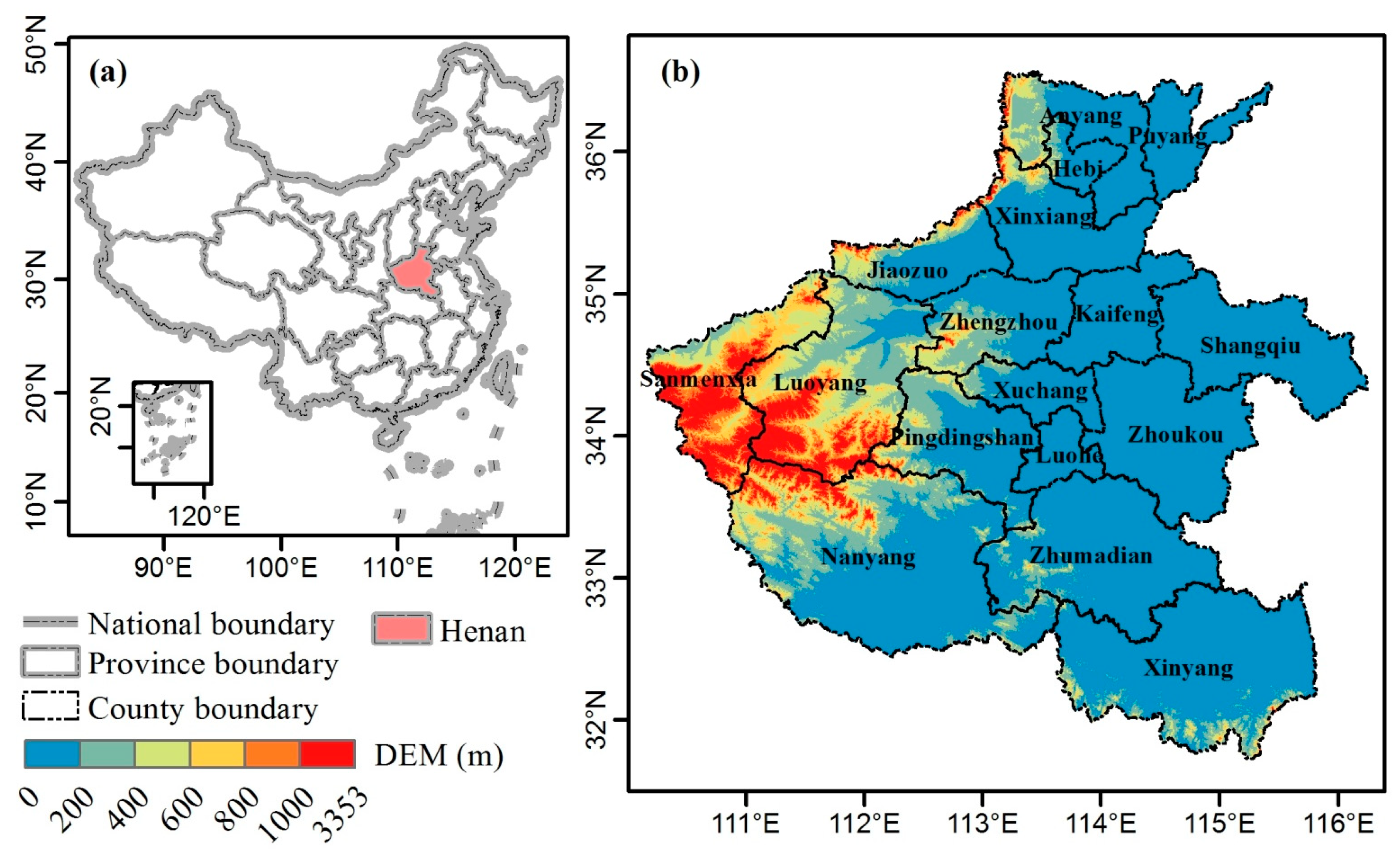
2.1. Study Area

Henan province was selected as our study area. Henan is located in the central and eastern part of China (31.38° N~37.37° N, 110.35° E~116.65° E) between the developed regions to the south-east and undeveloped ones to the north-west (Figure 1a). Henan consists of 17 prefecture cities with a total land area of about 167,000 km2 (Figure 1b). It has a warm temperate to subtropical, humid to semi-humid, monsoon climate. From the north to the south, the annual mean air temperature and the average annual precipitation ranges from 12 °C to 16 °C and ~530 mm to ~1380 mm, respectively. Elevation ranges from the low eastern regions of ~80 m to the high western regions of ~3353 m above sea level according to the 30 m Shuttle Radar Topography Mission digital elevation model (SRTM/DEM) (Figure 1b). More than 50% of the topography in Henan is plains, which is very beneficial for human life. According to the 2011 China Statistical Yearbook [12], Henan had the first highest household population and the third highest resident population in 2010. It also had the largest rural population and highest crop yields. It is a large economic province with the fifth highest gross domestic product (GDP) in China. As a large province in terms of both agriculture and population, Henan was chosen as a case area to study the changes of rural settlements and the accompanying rural land-use changes in the undeveloped inland of China under urbanization.

2.2. Data

2.2.1. Land-Use Datasets from the End of the 1980s to 2010

This study used the vector National Land-Use/Cover Database of China (NLUD-C) for three periods of the end of the 1980s, 2000, and 2010 and the dynamic database of the NLUD-C for four periods of the end of the 1980s–2000, 2000–2005, 2005–2008, and 2008–2010. NLUD-C was generated at a mapping scale of 1:100,000 by visual interpretation based on multi-source remote sensing data with a spatial resolution of approximately 30 m [34]. There was strict quality control in the data production by repeated visual interpretation and field verification. The thematic accuracy of construction land should reach 90% in a quality control [34]. The accuracy of the NLUD-C was evaluated at more than 95.41% using the selected samples of first-level types [34]. NLUD-C used a hierarchical classification system of six first-level types of land use and 25 second-level types. The six first-level land-use types consist of cultivated lands, woodlands, grasslands, water bodies, built-up lands, and unused lands. The built-up lands are composed of three sub-level types: urban lands, rural settlements, and industry-traffic lands. Detailed information about this database has been reported in a previous study [34]. In this study, we extracted the rural settlements for three periods and the dynamics for four periods in Henan province from the NLCD-C datasets. The four dynamic periods for the rural settlements were integrated into three research periods comprising the end of the 1980s–2000, 2000–2010, and the end of the 1980s–2010.

2.2.2. Auxiliary Data
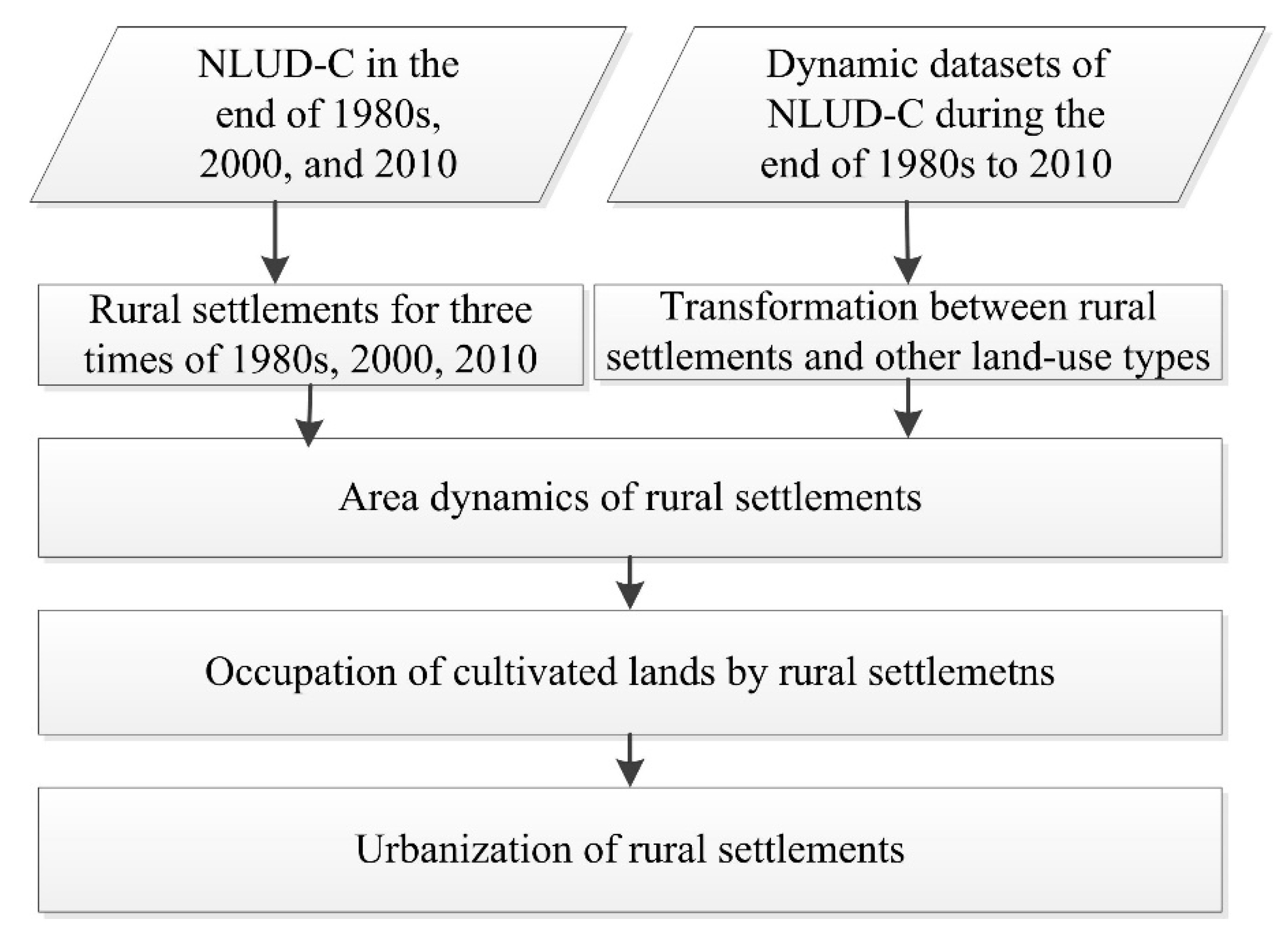
To characterize the distribution of rural settlements and potential regions of rural residential land changes, we used the 30 m SRTM/DEM data. This dataset was downloaded from the United States Geological Survey (USGS) to describe Henan’s topography.

2.3. Methods

2.3.1. Area Dynamic Analysis

We compiled statistics about the total area and the changes of rural settlements at two spatial scales, the entire province and 17 prefecture cities using Henan’s rural settlement datasets. The total area was analyzed at three points: the end of the 1980s, 2000 and 2010; and the total area changes were calculated for three research periods: the end of the 1980s–2000, 2000–2010 and the end of the 1980s–2010. The workflow of this study was shown in Figure 2.

2.3.2. Transformation Analysis between Rural Settlements and other Land-Use Types

Constructing a transformational matrix is a widely used approach to quantify conversions among land-use types [2]. We used a transformational matrix to analyze the conversions between rural residential lands and other land-use types during the three study periods across the entire province. The transformational matrix was generated based on the dynamic datasets of rural settlements. Three statuses describe the dynamics of rural settlements during each period: (1) no-change areas, (2) increased areas, and (3) decreased areas. The transformational matrix of rural settlements was composed of two parts: (1) those land-use types that were used to increase the rural residential lands; and (2) those land-use types that replaced rural residential lands when they decreased.
We then focused on the conversion of cultivated lands to the sprawl of rural settlements and the rural settlements to the sprawl of cities and towns in order to quantify the impact of rural settlement expansion on cultivated lands and the processes of rural settlement urbanization. The following equations (Equations (1) and (2)) were used to describe the occupation rate of cultivated lands (ORCL) and the urbanization rate of rural settlements (URRS) at two spatial scales of the entire province and 17 prefecture cities:
O R C L = A c l T × A r s × 100 %
U R R S = A u T × A r s × 100 %
where A c l is the area of cultivated lands occupied by the expansion of rural settlements at the end of a study period; T is the length of the study period, using year as a unit; A r s is the area of rural settlements at the beginning of a study period; and A u is the urbanization area converted from the extinction of rural settlements at the end of a study period.
As the area of rural settlements varies between different prefecture cities at the beginning of a study period, we used a ratio model (Equation (3)) to consistently compare the spatial differences of ORCL and URRS among 17 prefecture cities:
I = R C R P
where I is a relative rate of ORCL or URRS for each prefecture city to the entire province; RC is the rate of ORCL or URRS for each prefecture city; and RP is the rate of ORCL or URRS for the entire province. We defined that I > 1.05, 1.05 > I > 0.95, and I < 0.95, respectively, denoting that the prefecture cities had strong, normal, or weak rates of cultivated land occupation or rural settlement urbanization relative to the average level of the entire province. In mathematics, I equals 1 presenting that the rates of ORCL or URRS of each prefecture is consistent with the average of the entire province. Here, we slightly adjusted the strict threshold of 1 to a range of 1 ± 0.05 which are 1.05 and 0.95 in order to assess the development of each prefecture.

3. Results

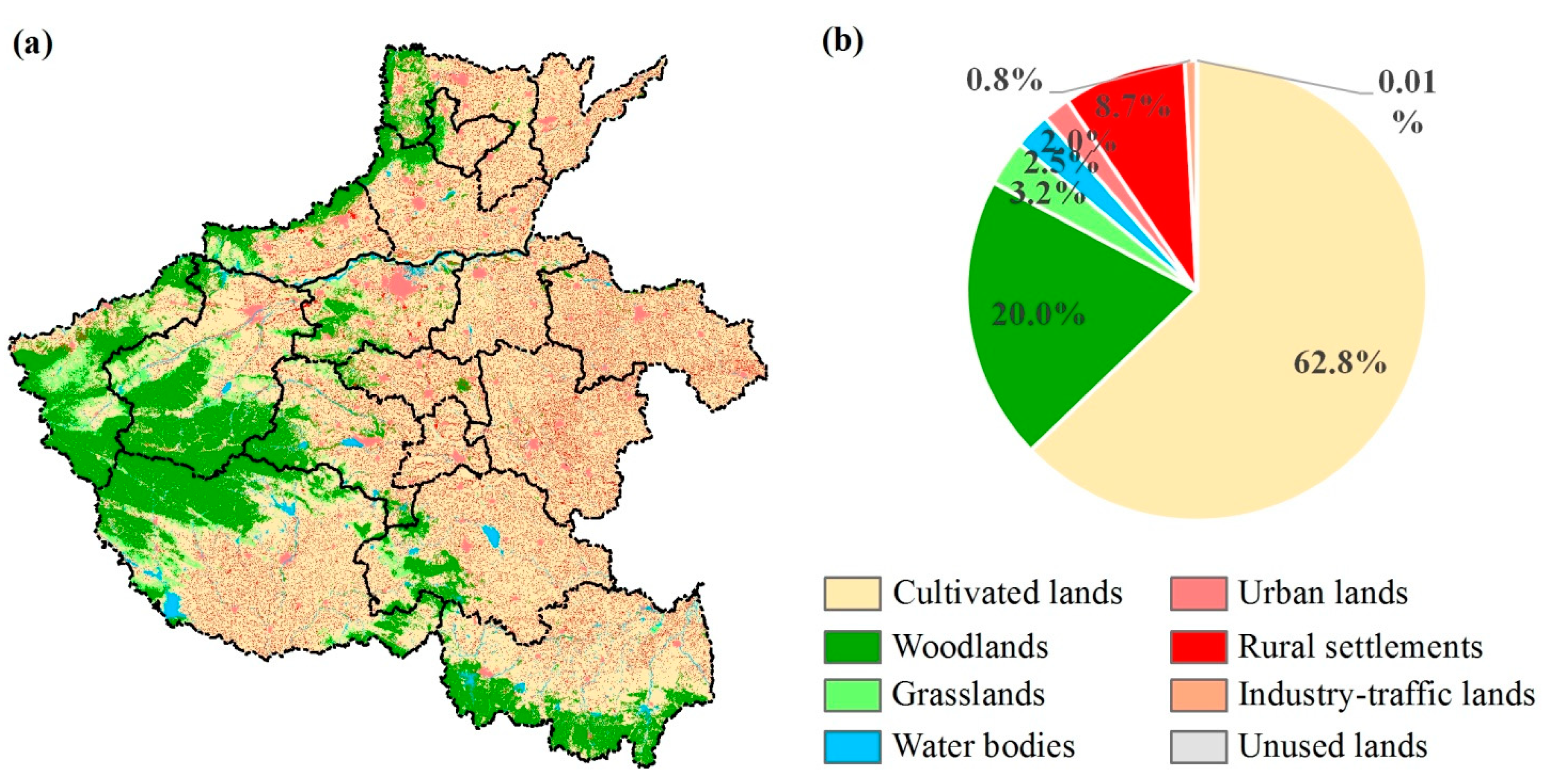
3.1. Land Use in Henan in 2010

Henan’s 2010 land-use datasets (Figure 3) show that cultivated lands, woodlands and built-up lands are the main land-use types, accounting for 63%, 20%, and 11.5% of Henan’s total area, respectively (Figure 3b). Cultivated lands have a wide distribution in Henan province except in hilly areas, like the west. Woodlands are mainly concentrated in the northern, western, and southern hill regions. Like cultivated lands, built-up lands are also in the plains of the east. Rural settlements are a subclass of the built-up lands. In 2010, rural settlements had an area of ~14,334 km2, 8.7% of Henan’s total area. The numerous rural settlements distribute unevenly on the space with a spatial characteristic of scarcity in the west and density in the east. The number and area of rural settlements are largely different between cities.

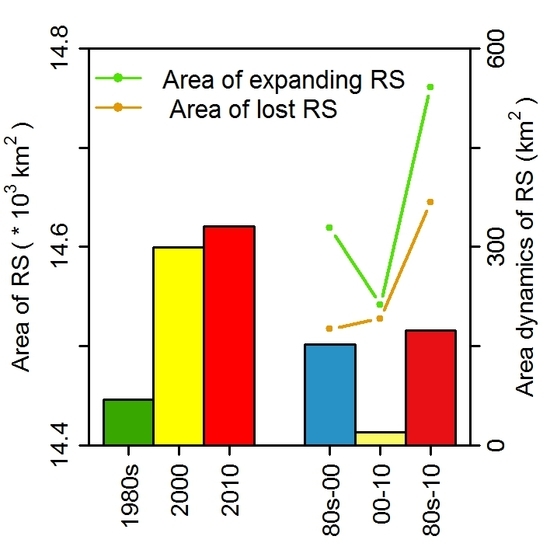
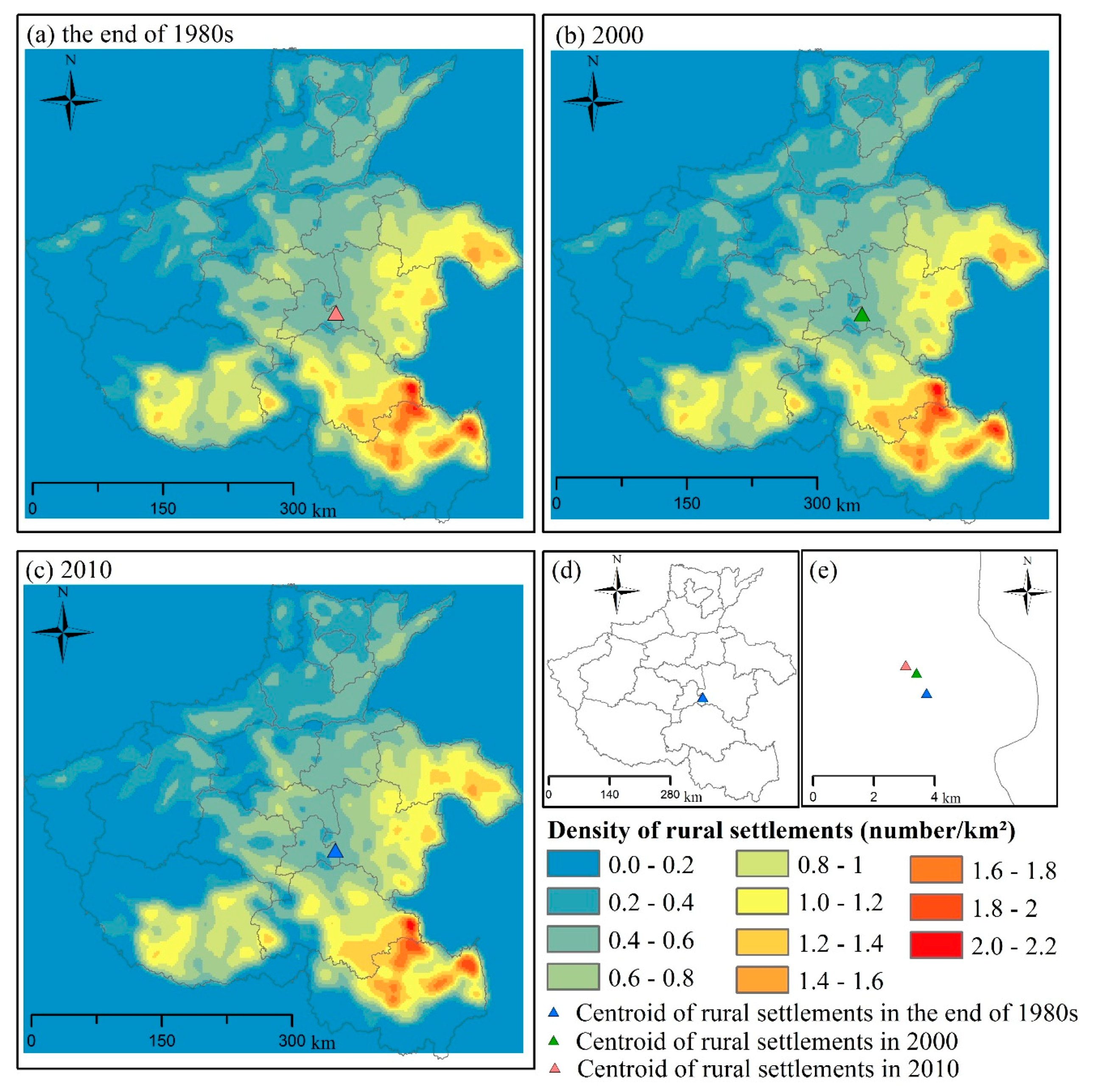
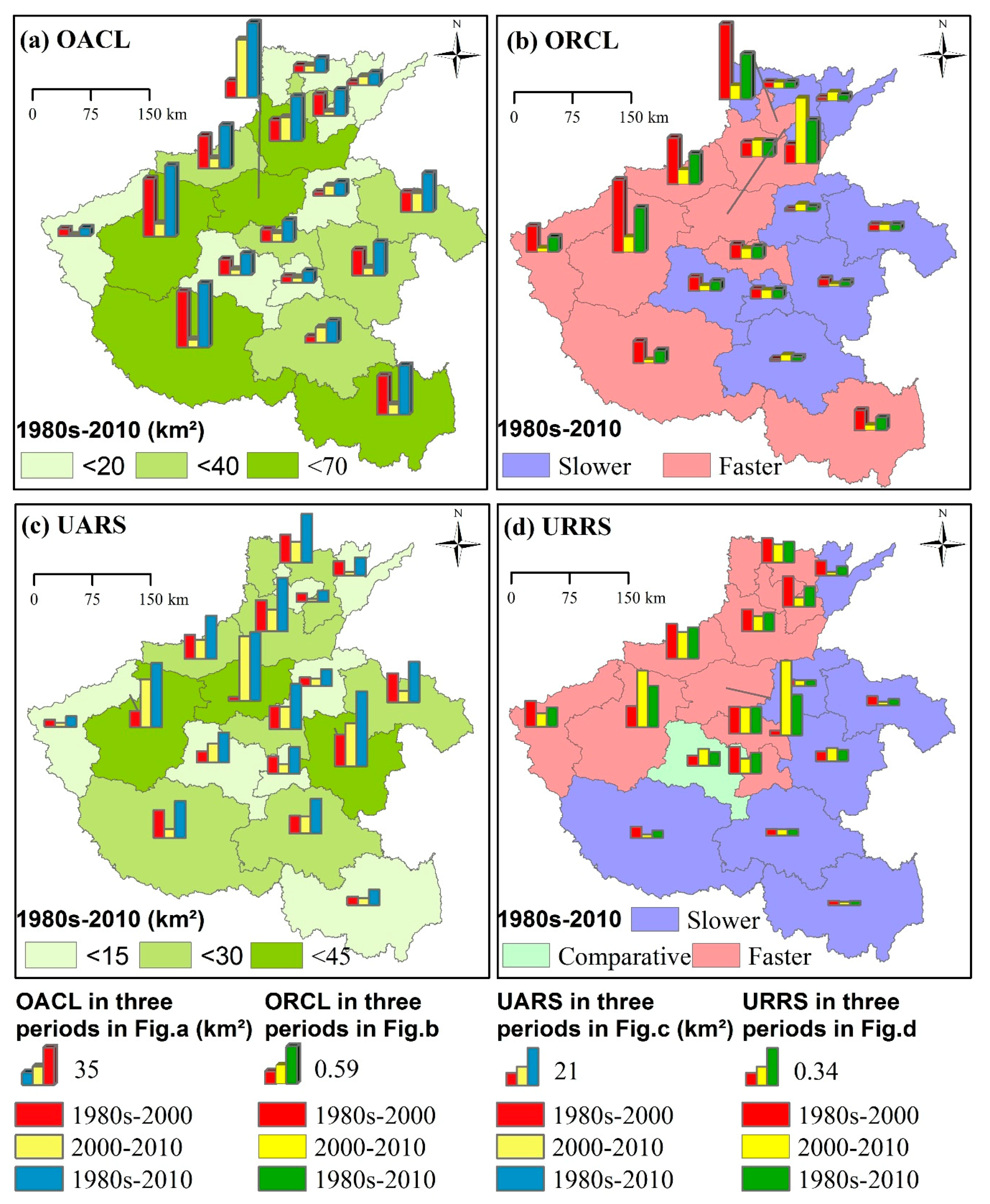
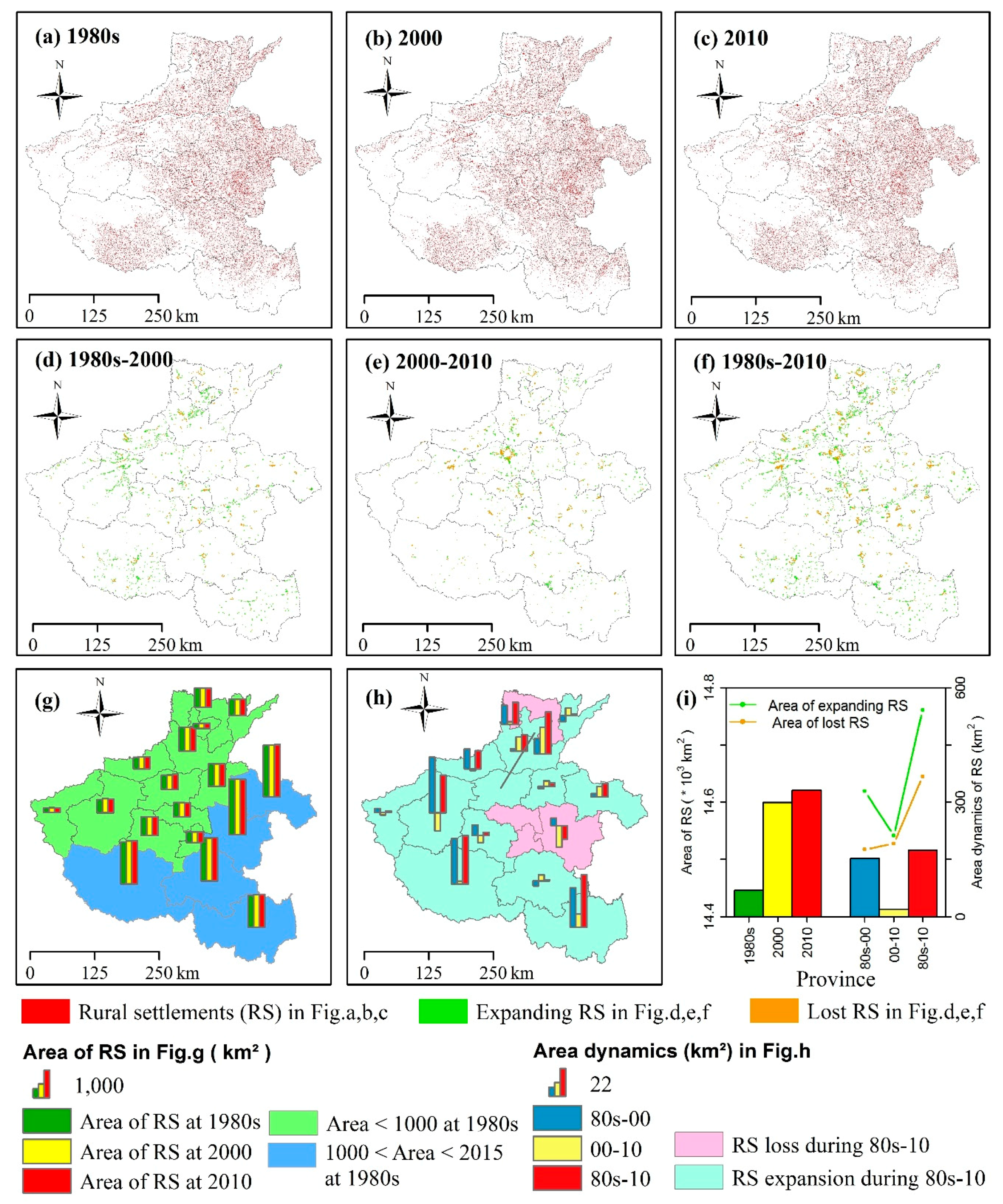
3.2. Dynamics of Rural Settlements from the End of the 1980s to 2010

We generated the rural settlement distribution at three points: the end of the 1980s, 2000, and 2010 (Figure 4a–c), and the dynamics of rural settlements during the three periods of the end of the 1980s–2000, 2000–2010, and the end of the 1980s–2010 (Figure 4d–f). The three rural settlement areas (RSAs) for each prefecture city suggest that RSAs in the southern prefecture cities were higher than those in the northern regions for all study times (Figure 4g). Most of the cities experienced a continuous increase in RSAs from the end of the 1980s to 2010 (Figure 4g). The dynamics of RSAs for individual cities during the three periods are shown in Figure 4h. The spatial patterns of the changes of RSAs during the end of the 1980s–2010 demonstrate that most of the cities experienced an increase of RSA in this period, except for four cities in the east (Figure 4h). The RSA of Henan increased continuously from ~14,450 km2 in the late 1980s to ~14,600 km2 in 2000. Then the increase was slower, reaching an area of ~14,620 km2 in 2010 (Figure 4i). Statistics on the expansion and loss of the RSA of Henan suggest that RSA has sequentially increased by ~329 km2 and ~212 km2, and decreased by ~176 km2 and 191 km2, respectively, during two sequential periods comprising the end of the 1980s–2000 and 2000–2010 (Figure 4i). This result reveals that the expansion of Henan’s RSA has slowed down, while the decline of Henan’s RSA has sped up.
The density maps at three times of the end of 1980s, 2000 and 2010 reveal that the rural settlements clustered more in the southern prefecture cities than the northern ones (Figure 5a–c). The density of rural settlements presented a negligible change from the end of 1980s to 2000. In contrast, there was a slightly more pronounced downtrend in the density of rural settlements from 2000 to 2010. The centroid of the rural settlements did not change significantly in the study period (Figure 5d). However, we can find a slight southward trend by comparing the centroids at the three study periods (Figure 5e).

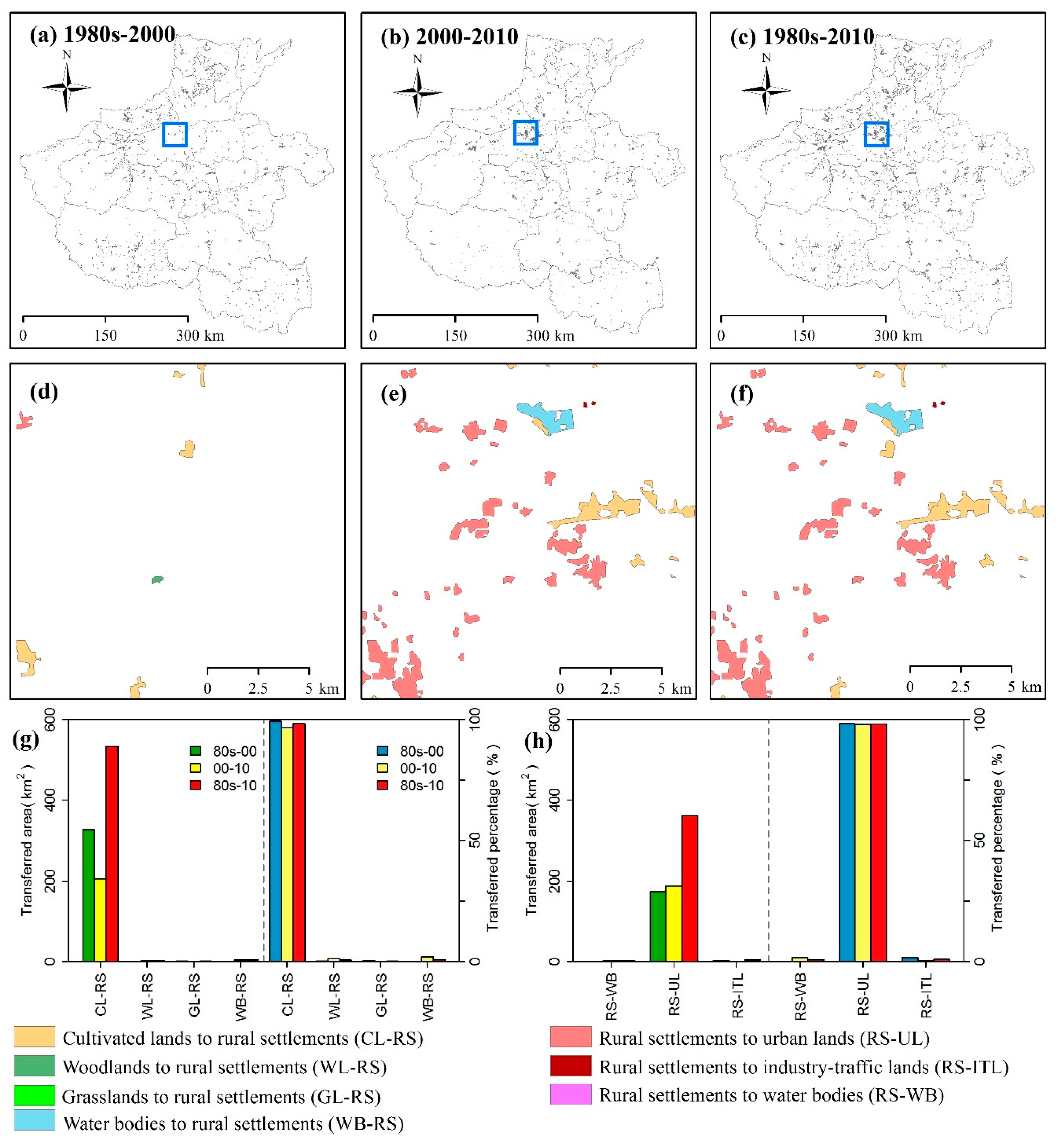
3.3. Interactions of Rural Settlements and other Land-Use Types

The expansion and decline of rural settlements occurred at the same time. The spatial patterns of the land-use conversions of Henan are shown in Figure 6a–f for the three study periods. During all the periods, rural settlement expansion occupied the land-use types of cultivated lands, woodlands, grasslands and water bodies (Figure 6a–f). Cultivated lands are the main land source for rural settlement sprawl, providing over 96% of the rural settlement expanded area in all study periods (Figure 6g). The loss of rural settlements supports the development of water bodies, urban, and industry-traffic lands. Conversion to urban lands is the main transformation of rural settlements with a proportion above 98% of the rural settlement lost area (Figure 6h).
The study of the entire province suggests rural settlement expansion has significantly influenced cultivated lands with a total occupation area of ~532 km2 in the end of the 1980s–2010 (Figure 6g). Therefore, we further examined the occupation area of cultivated lands (OACL) (Figure 7a), ORCL, and the spatial differences of ORCL (Figure 7b) during the three study periods at a prefecture city scale. OACL varies between prefecture cities and periods (Figure 7a). During the end of the 1980s–2010, four prefecture cities had an OACL of larger than 40 km2, and eight prefecture cities had less than 20 km2. The average OACL was ~27 km2. ORCL also changes between prefecture cities and periods (Figure 7b). During the end of the 1980s–2010, we can divide the prefecture cities into those with strong and weak impacts on cultivated lands according to the spatial differences of ORCL analyzed by the ratio model of Equation (3) (Figure 7b). There is a distinct boundary on the space between these two types of regions. The areas with severe impacts on cultivated land are distributed in the west, and those with weak impacts are in the east (Figure 7b).
Similarly, the study of the entire province demonstrates that rural settlements were mainly converted to urban lands (urbanization of rural settlements) with a total area of ~361 km2 at the end of the 1980s–2010 (Figure 6h). We examined the urbanization area of rural settlements (UARS) (Figure 7c), URRS, and the spatial differences of URRS (Figure 7d) during the three study periods at a prefecture city scale. During the end of the 1980s to 2010, three cities had the highest UARS at greater than 35 km2 and six cities had the least UARS of less than 15 km2 (Figure 7c). The average UARS is ~18 km2 in this period. The URRS of each city during the three study periods is shown in Figure 7d. From the end of the 1980s to 2010, we found three types of cities with strong, normal, and weak urbanization of rural settlements according to the spatial differences of URRS analyzed by the ratio model of Equation (3) (Figure 7d). The areas with strong URRS were clustered in the north-west and those with weak URRS were in the south-east. The prefecture city of Pingdingshan had a normal URRS, which corresponded to its location at the junction of the strong and weak urbanization regions (Figure 7d).

4. Discussion

4.1. Comparison with Previous Studies of Rural Settlements

This study explored the spatio-temporal dynamics of rural settlements and the associated interactions with other land-use types in Henan, especially the conversion of cultivated lands and urban lands, in the three study periods using multi-period land-use status and dynamic products. This study suggested there were numerous rural settlements in Henan, mainly concentrated on the plains. Early studies reported that rural settlements in China were small and densely gathered on the large plains [15,20,43]. The rural settlements in Henan reflect this typical feature of rural Chinese settlements both in landscape patterns and spatial distribution. This study showed that rural settlements were continuously increasing at the province level from the end of the 1980s to 2010, while the trends were slowing down. These results were consistent with the findings about rural settlement dynamics in China during the different periods of 1995–2005 [44] and 1990–2000 [15]. Meanwhile, the continuous expansion of rural settlements since the 1990s has been observed in many regional studies [14,16]. Due to the change of rural settlements corresponding to the level of socio-economic development of a given region [16], the dynamics of rural settlements varied markedly at the prefecture level (Figure 4h).
Land from cultivated lands, woodlands, grasslands, and water bodies supported the rural settlement expansion in Henan during the three study periods, with cultivated lands providing more than 96% of the expanded lands (Figure 6). Land-use changes caused by rural settlement encroachment had been observed in cultivated lands, woodlands, grasslands, water bodies, unused lands, and other lands in an early study by Tian, Yang and Zhang [15]). This early study reported croplands contributed 59.82% of the rural settlement expansion, followed by grasslands and other lands with fractions of 13.65% and 10.46%, respectively. The disparity in land source types and proportions between this study and the earlier study could be explained by the different spatial scales between province and nation. Rural settlement expansion at the cost of croplands has become a major land-use transition in China [25,29]. The prefecture cities with the highest OACL and the fastest ORCL were mainly distributed in the west of Henan (Figure 7a,b). More occupation of croplands occurred in the earlier period of the end of the 1980s–2000 at both the province and prefecture scales, except for the capital (Zhengzhou) of Henan (Figure 6g and Figure 7a,b). A study on the developed eastern areas of China also indicated that the impacts of rural settlement urbanization on cultivated lands varies between regions due to different urbanization modes [10]. However, this early study found the loss of cultivated lands caused by the expansion of villages increased from the late 1990s to the late 2000s. This differs from our results that OACL and ORCL had slight decreases from the former (the end of the 1980s–2000) to the later period (2000–2010) (Figure 6g and Figure 7a,b). This could be related to the different levels of development between the study areas. Within our study area, Zhengzhou, as the most developed region, had the only increasing positive trends of OACL and ORCL (Figure 7a,b), which were consistent with the results obtained from the eastern developed regions [10].
This study found that the lands from the loss of rural settlements were converted to water bodies, urban lands, and industry-traffic lands during the study periods, and that the conversion to urban land accounted for more than 98% of the lost rural settlements (Figure 6). The prefecture cities with the highest UARS were around the capital (Zhengzhou) and the northern prefecture cities showed faster URRS (Figure 7c,d). UARS in the later period of 2000–2010 was higher than that in the former period at the provincial scale (Figure 6h). Nevertheless, the temporal dynamics of UARS and URRS varied significantly between prefecture cities (Figure 7c,d). This could be explained by the different levels of socio-economic development and industrialization between prefecture cities. Zhengzhou is the capital and the largest city of Henan with the highest socio-economic development. The northern prefecture cities had a higher level of industrialization than the southern ones from the end of the 1980s–2010, especially at the end of the 1980s–2000 period [45,46,47]. The spatio-temporal patterns of UARS and URRS can be explained as the result of urbanization. Likewise, urban encroachment was identified as a mode to describe the disappearance of rural settlements [24]. Previous studies indicated that urban sprawl had caused numerous villages to die out and a general decrease of rural settlement area, especially in regions surrounding large cities [9,24].

4.2. Implications and Future Development

At present, a series of land consolidation policies have been implemented to improve land-use efficiency in rural regions [4,21,22]. This study on the dynamics of rural settlements, especially the expansion of rural settlements, may provide potential spatial information to develop reasonable policies to improve rural land efficiency in Henan. Although this work conducted relatively comprehensive analysis on the rural settlement dynamics, more studies are still needed in the future. For example, this study suggested that the area of rural settlement in Henan continuously increased during the end of the 1980s to 2010 at the province scale (Figure 4). However, the increasing trend of rural settlements was negative, while the lost trend was remarkably positive. Because of this, it is unclear how many differences exist between the dynamics of rural settlements in Henan and those in developed and other undeveloped regions. To better understand these questions, we will implement this study in larger regions or the entire country of China in future using the NLUD-C product or developing automatic algorithms to map the dynamics of rural settlements since the late 1980s based on multiple data sources (e.g., Landsat 8, Sentinel-2) [33,48]. LULCC in rural regions occurred globally under the influence of rapid socio-economic development and political changes [35,42]. Many issues have been caused along with LULCC including the abandonment of pastures and croplands [35,40], changes of rural tourism resources and landscapes [36,37,38], and the associated environment impacts of rural LULCC [39,41]. The methodology used in this study can be employed to examine rural LULCC in other territorial contexts for sustainable rural land management.
In addition, this study attempted to examine the impacts of the dynamics of rural settlements on local land-use changes. From the late 1980s to 2010, the expansion of rural settlements occupied ~532 km2 cultivated lands. The loss of cultivated lands caused by rapid rural settlement expansion is directly related to regional food security. This study could potentially facilitate the development and implementation of effective planning policies to manage cultivated lands in rural China sustainably [25]. Meanwhile, the rural residential lands were converted to urban lands with a positive trend under rapid urbanization (Figure 6h). As land changes are significant for the Earth system, they are relevant to environmental changes and sustainability [1,49]. Land-use changes in rural and exurban areas affect a variety of ecological structures, processes and services, including vegetation structure, local water and carbon cycles, public health, biodiversity and regional climate [5,50,51,52]. However, few studies have been established to quantify the impacts of rural settlement changes on local ecosystems and the environment. The description of changes in rural settlements and rural land uses in this work provide a database for subsequent studies on the environmental impacts. We will examine the potential consequences on the environment, including changes of carbon, water, and land-surface temperature in the future by using multiple remote-sensing products like the Moderate Resolution Imageing Spectroradiometer (MODIS) [53,54].

5. Conclusions

Rapid urbanization and economic growth accelerate land use in both urban and rural areas of China. Limited attention has been paid to this issue as it occurs in rural regions, especially those within undeveloped areas. This study mainly examined the spatio-temporal dynamics of rural settlements and the associated impact on local land uses in Henan, China, from the late 1980s to 2010 by using multi-period land-use status and dynamic products. We analyzed two land-use conversions in detail, including the impacts of rural settlement expansion on cultivated lands and the urbanization of rural settlements. We conducted this work during the three periods of the end of the 1980s–2000, 2000–2010, and the end of the 1980s–2010, at the two spatial scales of province and prefecture cities. The results indicate that the net area of rural settlements in Henan was increasing from the end of the 1980s to 2010. However, the increasing trend in the area of rural settlements is negative while the decreasing trend is positive in this period. From a provincial view, the impact on cultivated lands had a slightly negative trend, while an opposite trend was shown in the urbanization of rural settlements. Substantial variations took place between prefecture cities regarding the area dynamics, impacts on cultivated lands, and urbanization of rural settlements. An advantage of this study is to systematically examine the dynamics of rural settlements and the impact on local land-use types over a period about 20 years in an undeveloped area of Henan province, China. Further studies are needed to examine the potential drivers and consequences of rural settlement changes on the environment.

Author Contributions

J.W. took part in the research design and performed research, data analysis, and paper writing. W.Z. took part in data analysis and paper writing. Z.Z. designed the research and provided datasets.

Funding

This research was funded by the National Natural Science Foundation of China grant number 41701477.

Acknowledgments

We thank Sarah Xiao at Yale University and Scott Holman at the University of Colorado for the English editing of the manuscript.

Conflicts of Interest

The authors declare no conflict of interest.

References

  1. Lambin, E.F.; Meyfroidt, P. Global land use change, economic globalization, and the looming land scarcity. Proc. Natl. Acad. Sci. USA 2011, 108, 3465–3472. [Google Scholar] [CrossRef] [PubMed]
  2. Liu, J.; Liu, M.; Zhuang, D.; Zhang, Z.; Deng, X. Study on spatial pattern of land-use change in China during 1995–2000. Sci. China Ser. D Earth Sci. 2003, 46, 373–384. [Google Scholar]
  3. DeFries, R.; Pandey, D. Urbanization, the energy ladder and forest transitions in India’s emerging economy. Land Use Policy 2010, 27, 130–138. [Google Scholar] [CrossRef]
  4. Liu, Y.S.; Fang, F.; Li, Y.H. Key issues of land use in China and implications for policy making. Land Use Policy 2014, 40, 6–12. [Google Scholar] [CrossRef]
  5. Kalnay, E.; Cai, M. Impact of urbanization and land-use change on climate. Nature 2003, 423, 528–531. [Google Scholar] [CrossRef] [PubMed]
  6. Foley, J.A.; DeFries, R.; Asner, G.P.; Barford, C.; Bonan, G.; Carpenter, S.R.; Chapin, F.S.; Coe, M.T.; Daily, G.C.; Gibbs, H.K.; et al. Global consequences of land use. Science 2005, 309, 570–574. [Google Scholar] [CrossRef] [PubMed]
  7. McGranahan, G.; Marcotullio, P.; Bai, X.; Balk, D.; Braga, T.; Douglas, I.; Elmqvist, T.; Rees, W.; Satterthwaite, D.; Songsore, J. Urban systems. In Ecosystems and Human Well-Being: Current State and Trends; Island Press: Washington, DC, USA, 2005; pp. 795–825. [Google Scholar]
  8. Zhao, S.Q.; Liu, S.G.; Zhou, D.C. Prevalent vegetation growth enhancement in urban environment. Proc. Natl. Acad. Sci. USA 2016, 113, 6313–6318. [Google Scholar] [CrossRef] [PubMed]
  9. Li, D.M.; Wang, D.Y.; Li, H.; Zhang, S.W.; Zhang, X.D.; Tao, Y. The effects of urban sprawl on the spatial evolution of rural settlements: A case study in Changchun, China. Sustainability 2016, 8, 736. [Google Scholar] [CrossRef]
  10. Deng, X.Z.; Huang, J.K.; Rozelle, S.; Zhang, J.P.; Li, Z.H. Impact of urbanization on cultivated land changes in China. Land Use Policy 2015, 45, 1–7. [Google Scholar] [CrossRef]
  11. Wang, H.; Wang, L.L.; Su, F.B.; Tao, R. Rural residential properties in China: Land use patterns, efficiency and prospects for reform. Habitat Int. 2012, 36, 201–209. [Google Scholar] [CrossRef]
  12. NSBC. China Statistical Yearbook 2011; China Statistics Press: Beijing, China, 2011. [Google Scholar]
  13. NSBC. China Statistical Yearbook 2000; China Statistics Press: Beijing, China, 2000. [Google Scholar]
  14. Long, H.L.; Liu, Y.S.; Wu, X.Q.; Dong, G.H. Spatio-temporal dynamic patterns of farmland and rural settlements in Su-Xi-Chang region: Implications for building a new countryside in coastal China. Land Use Policy 2009, 26, 322–333. [Google Scholar] [CrossRef]
  15. Tian, G.J.; Yang, Z.F.; Zhang, Y.Q. The spatio-temporal dynamic pattern of rural residential land in China in the 1990s using landsat tm images and GIS. Environ. Manag. 2007, 40, 803–813. [Google Scholar] [CrossRef] [PubMed]
  16. Long, H.L.; Hellig, G.K.; Li, X.B.; Zhang, M. Socio-economic development and land-use change: Analysis of rural housing land transition in the transect of the Yangtse River, China. Land Use Policy 2007, 24, 141–153. [Google Scholar] [CrossRef]
  17. Oldfield, P. Rural settlement and economic development in Southern Italy: Troia and its contado, c.1020–c.1230. J. Mediev. Hist. 2005, 31, 327–345. [Google Scholar] [CrossRef]
  18. Zhou, G.H.; He, Y.H.; Tang, C.L.; Yu, T.; Xiao, G.Z.; Zhong, T. Dynamic mechanism and present situation of rural settlement evolution in China. J. Geogr. Sci. 2013, 23, 513–524. [Google Scholar] [CrossRef]
  19. Marsden, T. Rural geography trend report: The social and political bases of rural restructuring. Prog. Hum. Geogr. 1996, 20, 246–258. [Google Scholar] [CrossRef]
  20. Yang, R.; Xu, Q.; Long, H.L. Spatial distribution characteristics and optimized reconstruction analysis of China’s rural settlements during the process of rapid urbanization. J. Rural Stud. 2016, 47, 413–424. [Google Scholar] [CrossRef]
  21. Li, Y.R.; Liu, Y.S.; Long, H.L.; Cui, W.G. Community-based rural residential land consolidation and allocation can help to revitalize hollowed villages in traditional agricultural areas of China: Evidence from Dancheng County, Henan Province. Land Use Policy 2014, 39, 188–198. [Google Scholar] [CrossRef]
  22. Long, H.L.; Li, Y.R.; Liu, Y.S.; Woods, M.; Zou, J. Accelerated restructuring in rural China fueled by ‘increasing vs. Decreasing balance’ land-use policy for dealing with hollowed villages. Land Use Policy 2012, 29, 11–22. [Google Scholar] [CrossRef]
  23. Liu, Y.S.; Liu, Y.; Chen, Y.F.; Long, H.L. The process and driving forces of rural hollowing in China under rapid urbanization. J. Geogr. Sci. 2010, 20, 876–888. [Google Scholar] [CrossRef]
  24. Tian, G.J.; Qiao, Z.; Gao, X.L. Rural settlement land dynamic modes and policy implications in Beijing metropolitan region, China. Habitat Int. 2014, 44, 237–246. [Google Scholar] [CrossRef]
  25. Su, S.L.; Zhang, Q.; Zhang, Z.H.; Zhi, J.J.; Wu, J.P. Rural settlement expansion and paddy soil loss across an ex-urbanizing watershed in eastern coastal China during market transition. Reg. Environ. Chang. 2011, 11, 651–662. [Google Scholar] [CrossRef]
  26. Zhang, Q.F.; Wu, J.L. Political dynamics in land commodification: Commodifying rural land development rights in Chengdu, China. Geoforum 2017, 78, 98–109. [Google Scholar] [CrossRef]
  27. Guo, X.-D.; Zhang, Q.-Y.; Ma, L.-B. Analysis of the spatial distribution character and its influence factors of rural settlement in transition-region between mountain and hilly. Econ. Geogr. 2012, 32, 114–120. (In Chinese) [Google Scholar]
  28. Huaiting, Y.; Zongxing, C. Spatial distribution and evolution of the rural settlement in Shaanxi. Hum. Geogr. 1995, 10, 17–24. (In Chinese) [Google Scholar]
  29. Long, H.L.; Li, T.T. The coupling characteristics and mechanism of farmland and rural housing land transition in China. J. Geogr. Sci. 2012, 22, 548–562. [Google Scholar] [CrossRef]
  30. Xi, F.M.; He, H.S.; Clarke, K.C.; Hu, Y.M.; Wu, X.Q.; Liu, M.; Shi, T.M.; Geng, Y.; Gao, C. The potential impacts of sprawl on farmland in northeast China-evaluating a new strategy for rural development. Landsc. Urban Plan. 2012, 104, 34–46. [Google Scholar] [CrossRef]
  31. Wulder, M.A.; Masek, J.G.; Cohen, W.B.; Loveland, T.R.; Woodcock, C.E. Opening the archive: How free data has enabled the science and monitoring promise of landsat. Remote Sens. Environ. 2012, 122, 2–10. [Google Scholar] [CrossRef]
  32. Wulder, M.A.; White, J.C.; Goward, S.N.; Masek, J.G.; Irons, J.R.; Herold, M.; Cohen, W.B.; Loveland, T.R.; Woodcock, C.E. Landsat continuity: Issues and opportunities for land cover monitoring. Remote Sens. Environ. 2008, 112, 955–969. [Google Scholar] [CrossRef]
  33. Wulder, M.A.; White, J.C.; Loveland, T.R.; Woodcock, C.E.; Belward, A.S.; Cohen, W.B.; Fosnight, E.A.; Shaw, J.; Masek, J.G.; Roy, D.P. The global landsat archive: Status, consolidation, and direction. Remote Sens. Environ. 2016, 185, 271–283. [Google Scholar] [CrossRef]
  34. Zhang, Z.X.; Wang, X.; Zhao, X.L.; Liu, B.; Yi, L.; Zuo, L.J.; Wen, Q.K.; Liu, F.; Xu, J.Y.; Hu, S.G. A 2010 update of national land use/cover database of China at 1:100,000 scale using medium spatial resolution satellite images. Remote Sens. Environ. 2014, 149, 142–154. [Google Scholar] [CrossRef]
  35. Bucala-Hrabia, A. Long-term impact of socio-economic changes on agricultural land use in the Polish Carpathians. Land Use Policy 2017, 64, 391–404. [Google Scholar] [CrossRef]
  36. Statuto, D.; Picuno, P. Valorisation of vernacular farm buildings for the sustainable development of rural tourism in mountain areas of the Adriatic-ionian macro-region. J. Agric. Eng. 2017, 48, 21–26. [Google Scholar] [CrossRef]
  37. Statuto, D.; Cillis, G.; Picuno, P. Using historical maps within a gis to analyze two centuries of rural landscape changes in Southern Italy. Land 2017, 6, 65. [Google Scholar] [CrossRef]
  38. Kupkova, L.; Bicik, I. Landscape transition after the collapse of communism in Czechia. J. Maps 2016, 12, 526–531. [Google Scholar] [CrossRef]
  39. Statuto, D.; Cillis, G.; Picuno, P. Analysis of the effects of agricultural land use change on rural environment and landscape through historical cartography and gis tools. J. Agric. Eng. 2016, 47, 28–39. [Google Scholar] [CrossRef]
  40. Kuemmerle, T.; Hostert, P.; Radeloff, V.C.; van der Linden, S.; Perzanowski, K.; Kruhlov, I. Cross-border comparison of post-socialist farmland abandonment in the Carpathians. Ecosystems 2008, 11, 614–628. [Google Scholar] [CrossRef]
  41. MacDonald, D.; Crabtree, J.R.; Wiesinger, G.; Dax, T.; Stamou, N.; Fleury, P.; Lazpita, J.G.; Gibon, A. Agricultural abandonment in mountain areas of Europe: Environmental consequences and policy response. J. Environ. Manag. 2000, 59, 47–69. [Google Scholar] [CrossRef]
  42. Griffiths, P.; Muller, D.; Kuemmerle, T.; Hostert, P. Agricultural land change in the Carpathian ecoregion after the breakdown of socialism and expansion of the European Union. Environ. Res. Lett. 2013, 8, 045024. [Google Scholar] [CrossRef]
  43. Tian, G.J.; Qiao, Z.; Zhang, Y.Q. The investigation of relationship between rural settlement density, size, spatial distribution and its geophysical parameters of China using landsat TM images. Ecol. Model. 2012, 231, 25–36. [Google Scholar] [CrossRef]
  44. Song, W.; Liu, M.L. Assessment of decoupling between rural settlement area and rural population in China. Land Use Policy 2014, 39, 331–341. [Google Scholar] [CrossRef]
  45. HSB. Henan Statistical Yearbook 1991; China Statistics Press: Beijing, China, 1991. [Google Scholar]
  46. HSB. Henan Statistical Yearbook 2001; China Statistics Press: Beijing, China, 2001. [Google Scholar]
  47. HSB. Henan Statistical Yearbook 2011; China Statistics Press: Beijing, China, 2011. [Google Scholar]
  48. Drusch, M.; Del Bello, U.; Carlier, S.; Colin, O.; Fernandez, V.; Gascon, F.; Hoersch, B.; Isola, C.; Laberinti, P.; Martimort, P.; et al. Sentinel-2: Esa’s optical high-resolution mission for GMEs operational services. Remote Sens. Environ. 2012, 120, 25–36. [Google Scholar] [CrossRef]
  49. Turner, B.L.; Lambin, E.F.; Reenberg, A. Land change science special feature: The emergence of land change science for global environmental change and sustainability. Proc. Natl. Acad. Sci. USA 2008, 105, 2751. [Google Scholar]
  50. Brown, D.G.; Johnson, K.M.; Loveland, T.R.; Theobald, D.M. Rural land-use trends in the conterminous United States, 1950–2000. Ecol. Appl. 2005, 15, 1851–1863. [Google Scholar] [CrossRef]
  51. Dale, V.; Archer, S.; Chang, M.; Ojima, D. Ecological impacts and mitigation strategies for rural land management. Ecol. Appl. 2005, 15, 1879–1892. [Google Scholar] [CrossRef]
  52. Hansen, A.J.; Knight, R.L.; Marzluff, J.M.; Powell, S.; Brown, K.; Gude, P.H.; Jones, A. Effects of exurban development on biodiversity: Patterns, mechanisms, and research needs. Ecol. Appl. 2005, 15, 1893–1905. [Google Scholar] [CrossRef]
  53. Running, S.W.; Mu, Q.; Zhao, M.; Moreno, A.; MODIS Global Terrestrial Evapotranspiration (ET) Product (NASA MOD16a2/a3). NASA Earth Observing System MODIS Land Algorithm, Collection 6 2017. Available online: https://ladsweb.modaps.eosdis.nasa.gov/missions-and-measurements/modis/MOD16_ET_User-Guide_2017.pdf (accessed on 1 June 2017).
  54. Wan, Z.M. New refinements and validation of the modis land-surface temperature/emissivity products. Remote Sens. Environ. 2008, 112, 59–74. [Google Scholar] [CrossRef]
Figure 1. Henan province in China is selected as a study area. (a) The location of Henan. (b) The digital elevation model (DEM) of Henan.
Sustainability 10 01490 g001
Figure 2. The workflow of this study.
Sustainability 10 01490 g002
Figure 3. The distribution (a) and proportion (b) of land uses in Henan in 2010.
Sustainability 10 01490 g003
Figure 4. (ac) Rural settlements at three points: the end of the 1980s, 2000, and 2010. (df) The dynamics of rural settlements in three periods: the end of the 1980s–2010 (80s–00), 2000–2010 (00–10), and the end of the 1980s–2010 (80s–10). (g) Statistics of rural settlement area for each prefecture city in the three periods. (h) Statistics for the dynamics of rural settlement area for each prefecture city in the three periods. (i) Statistics of area, area dynamics, expansion area, and lost area of rural settlements during the study periods.
Sustainability 10 01490 g004
Figure 5. (ac) Density maps of rural settlements at three study times of the end of the 1980s, 2000, and 2010. (d,e) The centroids of rural settlements at the three study times.
Sustainability 10 01490 g005
Figure 6. (ac) The transformations of rural settlements and other land-use types in three periods of the end of the 1980s–2000 (80s–00), 2000–2010 (00–10), and the end of the 1980s–2010 (80s–10). (df) The zoom-in views correspond to the region highlighted by a blue box in Figure (ac). (g) Statistics of converted area and proportion from other land-use types to rural settlements in the three study periods. (h) Statistics of converted area and proportion from rural settlements to other land-use types in the three study periods.
Sustainability 10 01490 g006
Figure 7. (a) The occupation area of cultivated lands (OACL) for each prefecture city during the three periods of the end of the 1980s–2000, 2000–2010, and the end of the 1980s–2010. (b) The occupation rate of cultivated lands (ORCL) for each prefecture city during the three periods. (c) The urbanization area of rural settlements (UARS) for each prefecture city during the three periods. (d) The urbanization rate of rural settlements (URRS) for each prefecture city during the three periods.
Sustainability 10 01490 g007

