
Co-Occurrence of Marine Extremes Induced by Tropical Storms and an Ocean Eddy in Summer 2016: Anomalous Hydrographic Conditions in the Pacific Shelf Waters off Southeast Hokkaido, Japan


Abstract
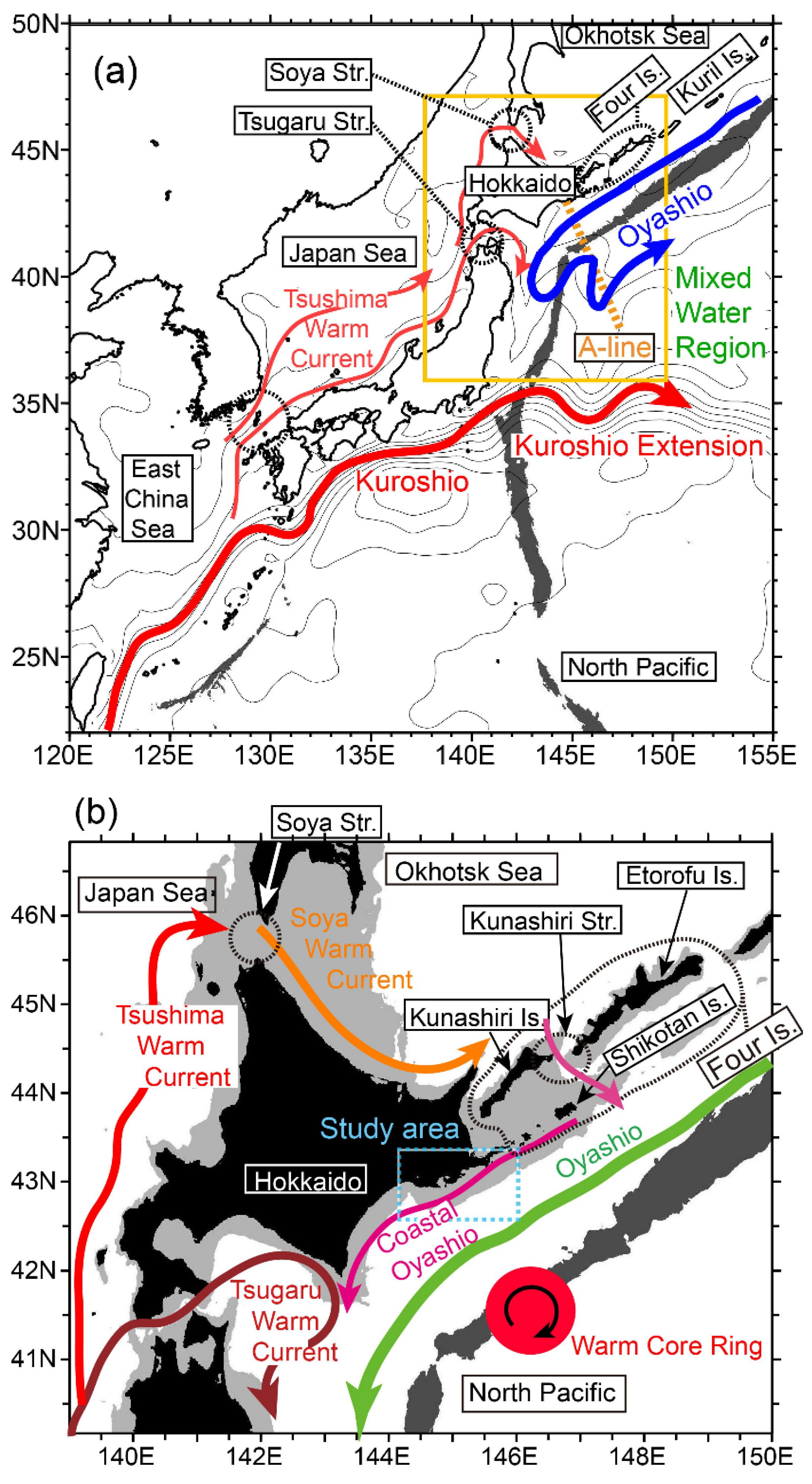
:1. Introduction
2. Materials and Methods
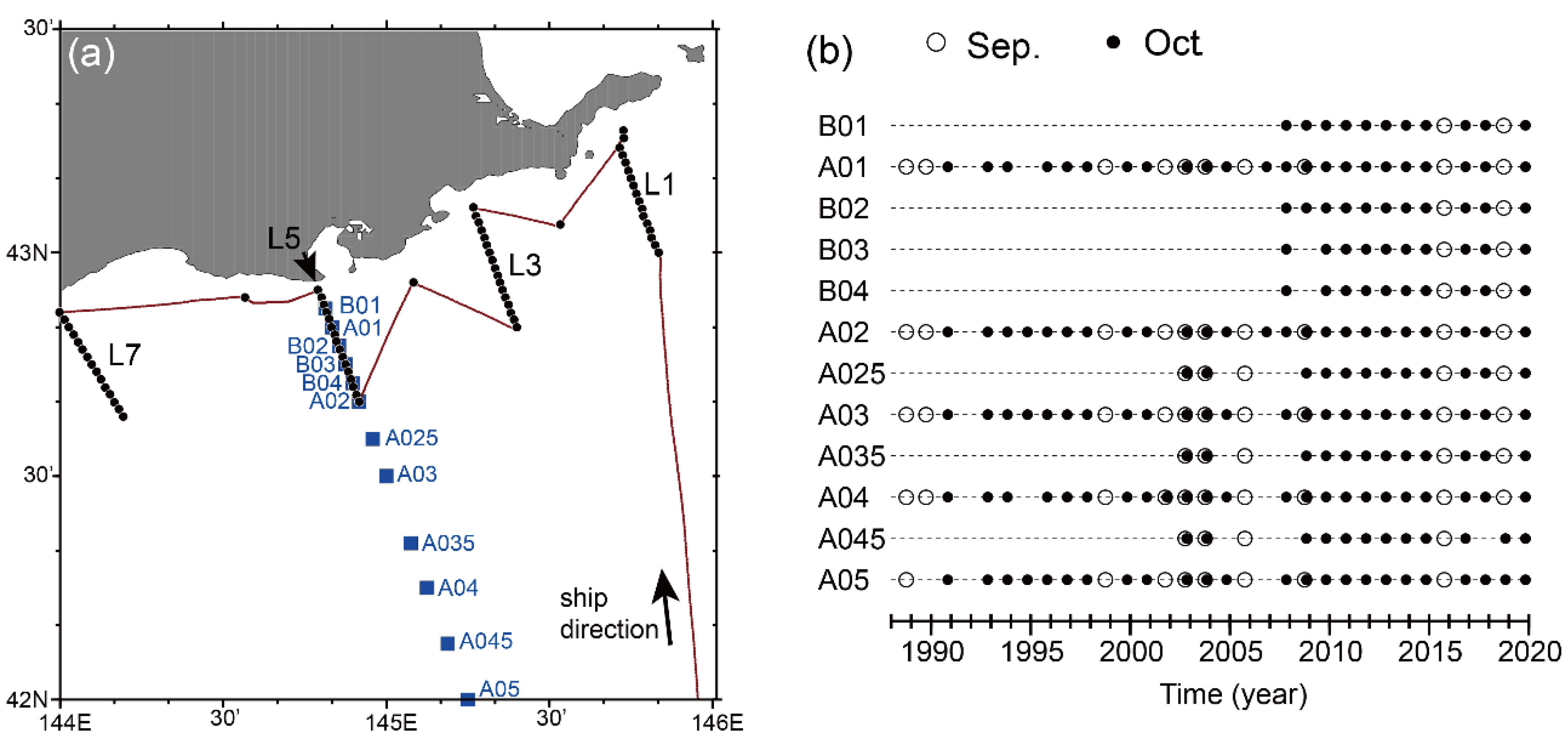
2.1. Intensive Measurements on the Pacific Shelf in October 2016
2.2. Long-Term CTD Data along the A-Line
2.3. Historical Current Velocities at the Sea Surface
2.4. Ocean Simulation
2.4.1. Reanalysis Data from a 1/10° Ocean Forecast System
2.4.2. High-resolution 1/50° Ocean Model
2.5. Particle-Tracking Experiment
3. Results
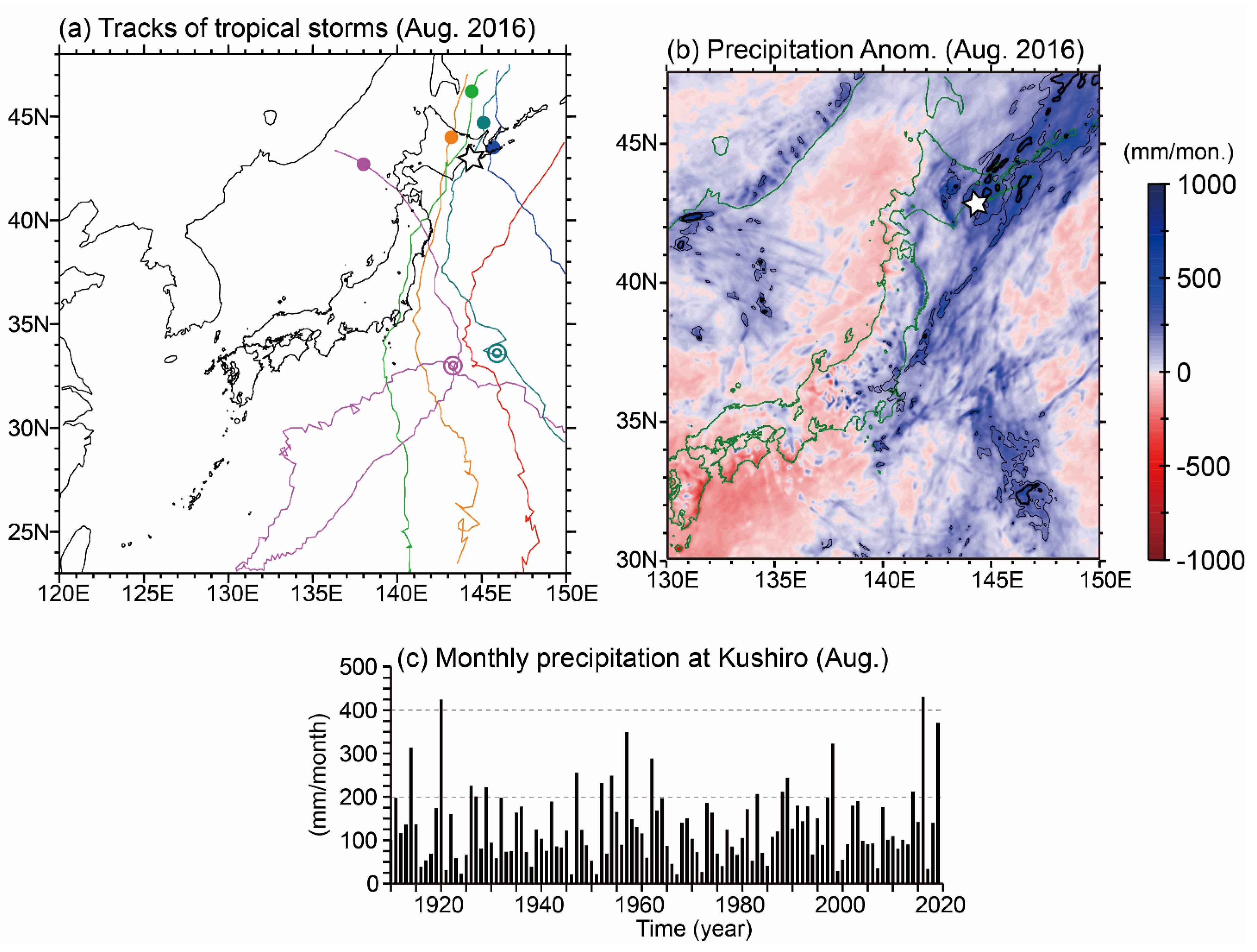
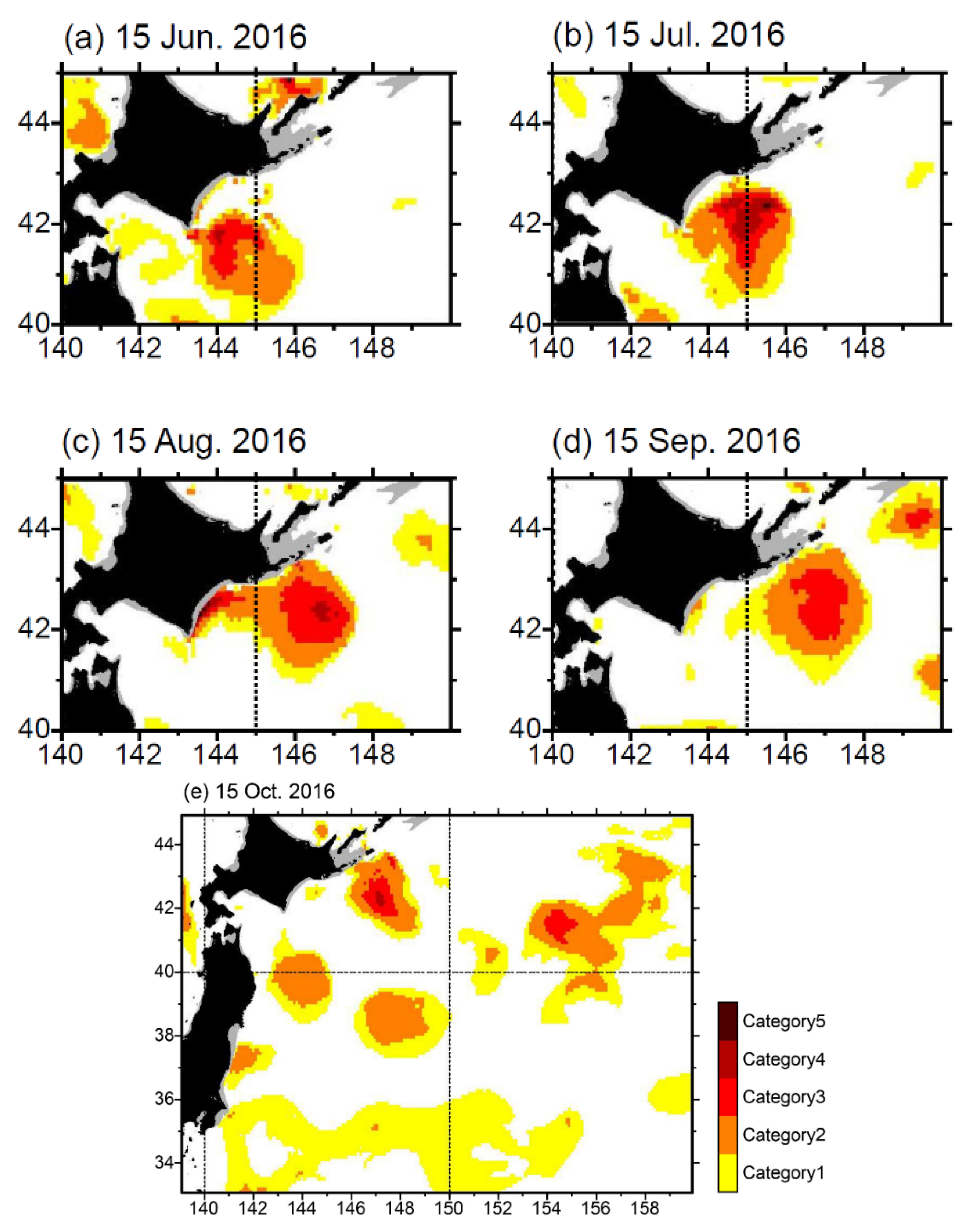
3.1. Overview of the Weather and Marine Extremes in Summer 2016
3.2. Observed Results
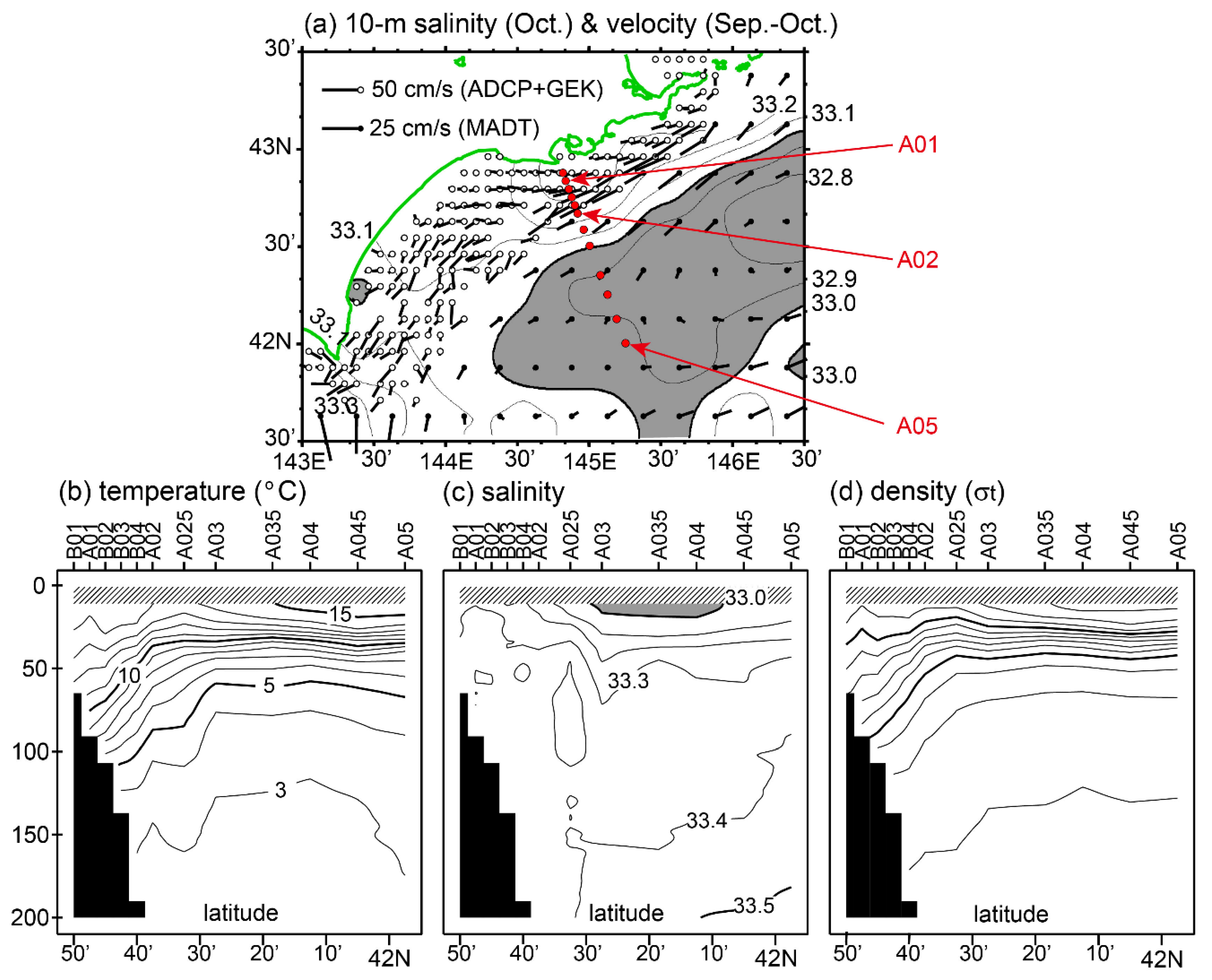
3.2.1. Climatological Conditions in September–October
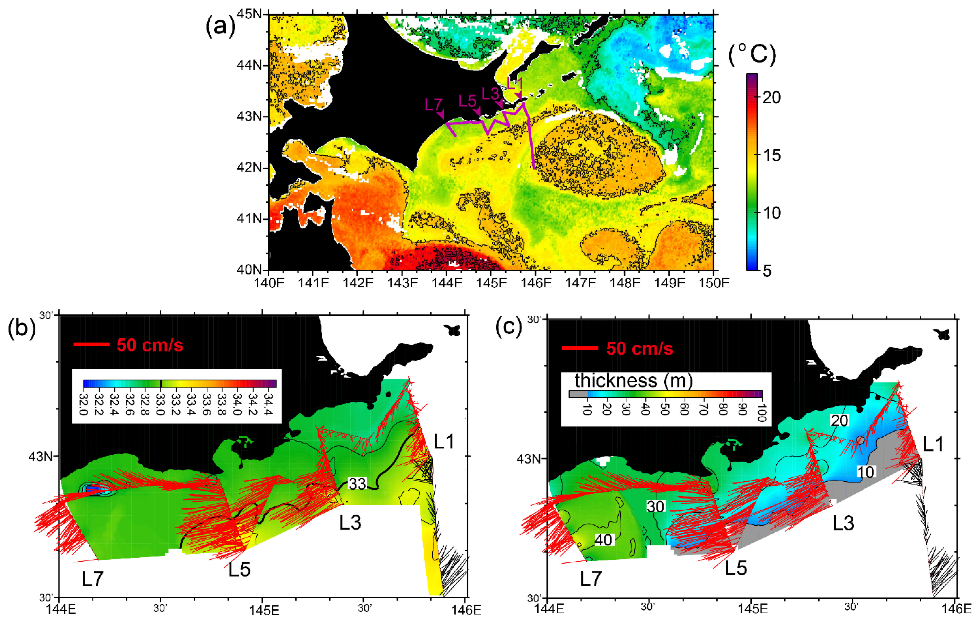
3.2.2. Hydrographic Conditions in October 2016
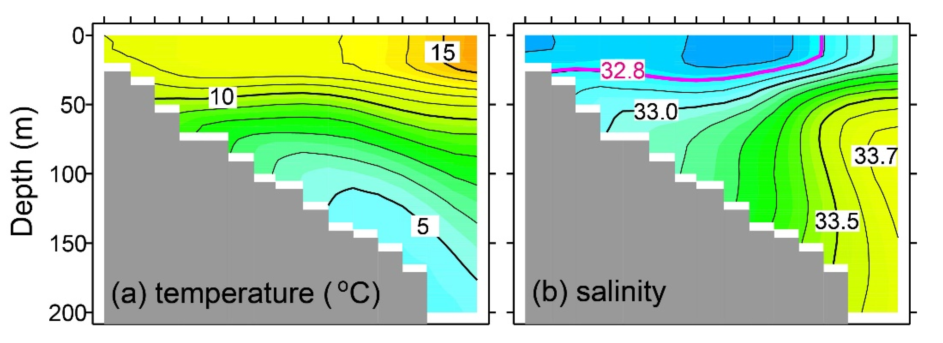
3.2.3. Peculiarity of the Salinity Structure in October 2016
3.3. Simulation Results
3.3.1. Simulation by the 1/50° Ocean Model
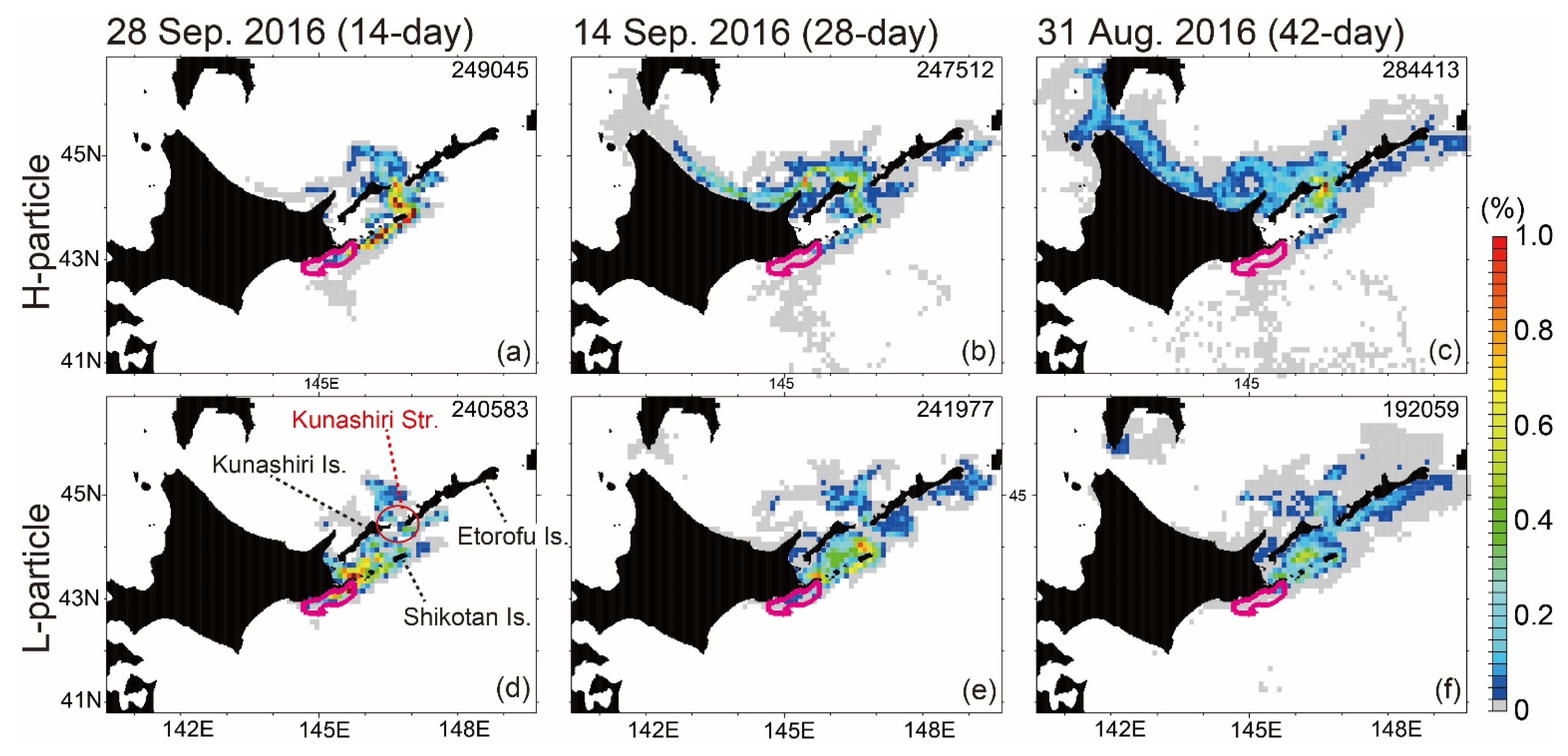
3.3.2. Particle-Tracking Experiment

4. Discussion
5. Conclusions and Remarks
Author Contributions
Funding
Institutional Review Board Statement
Informed Consent Statement
Data Availability Statement
Acknowledgments
Conflicts of Interest
Appendix A
References
- Seneviratne, S.I.; Nicholls, N.; Easterling, D.; Goodess, C.M.; Kanae, S.; Kossin, J.; Luo, Y.; Marengo, J.; McInnes, K.; Rahimi, M.; et al. Changes in Climate Extremes and their Impacts on the Natural Physical Environment. In Managing the Risks of Extreme Events and Disasters to Advance Climate Change Adaptation, 1st ed.; Field, C.B., Barros, V., Stocker, T.F., Qin, D., Dokken, D.J., Ebi, K.L., Mastrandrea, M.D., Mach, K.J., Plattner, G.-K., Allen, S.K., et al., Eds.; Cambridge University Press: Cambridge, UK, 2012; A Special Report of Working Groups I and II of the Intergovernmental Panel on Climate Change (IPCC); pp. 109–230. Available online: https://www.ipcc.ch/site/assets/uploads/2018/03/SREX-Chap3_FINAL-1.pdf (accessed on 6 July 2020).
- Fischer, E.M.; Knutti, R. Anthropogenic contribution to global occurrence of heavy-precipitation and high-temperature extremes. Nat. Clim. Chang. 2015, 5, 560–564. [Google Scholar] [CrossRef]
- Easterling, D.R.; Kunkel, K.E.; Wehner, M.F.; Sun, L. Detection and attribution of climate extremes in the observed record. Weather Clim. Extrem. 2016, 11, 17–27. [Google Scholar] [CrossRef] [Green Version]
- Mitchell, J.F.B.; Lowe, J.; Wood, R.A.; Vellinga, M. Extreme events due to human-induced climate change. Phil. Trans. R. Soc. A 2006, 364, 2117–2133. [Google Scholar] [CrossRef] [PubMed]
- World Meteorological Organization. The Global Climate 2001–2010: A Decade of Climate Extremes; Series No.1103; WMO: Geneva, Switzerland, 2013; pp. 1–110. [Google Scholar]
- Kuroda, H.; Suyama, S.; Miyamoto, H.; Nakanowatari, T.; Setou, T. Interdecadal variability of the Western Subarctic Gyre in the North Pacific Ocean. Deep-Sea Res. Part I 2021, 169, 103461. [Google Scholar] [CrossRef]
- Kuroda, H.; Wagawa, T.; Kakehi, S.; Shimizu, Y.; Kusaka, A.; Okunishi, T.; Hasegawa, D.; Ito, S. Long-term mean and seasonal variation of altimetry-derived Oyashio transport across the A-line off the southeastern coast of Hokkaido, Japan. Deep-Sea Res. Part I 2017, 121, 95–109. [Google Scholar] [CrossRef]
- Kuroda, H.; Wagawa, T.; Shimizu, Y.; Ito, S.; Kakehi, S.; Okunishi, T.; Ohno, S.; Kusaka, A. Interdecadal decrease of the Oyashio transport on the continental slope off the southeastern coast of Hokkaido, Japan. J. Geophys. Res. 2015, 120, 2504–2522. [Google Scholar] [CrossRef]
- Kuroda, H.; Yokouchi, K. Interdecadal decrease in potential fishing areas for Pacific saury off the southeastern coast of Hokkaido, Japan. Fish. Oceanogr. 2017, 26, 439–454. [Google Scholar] [CrossRef]
- Miyama, T.; Minobe, S.; Goto, H. Marine heatwave of sea surface temperature of the Oyashio region in summer in 2010–2016. Front. Mar. Sci. 2021, 7, 576240. [Google Scholar] [CrossRef]
- Takizawa, T. Characteristics of the Soya Warm Current in the Okhotsk Sea. J. Oceanogr. Soc. Jpn. 1982, 38, 281–292. [Google Scholar] [CrossRef]
- Uchimoto, K.; Mitsudera, H.; Ebuchi, N.; Miyazawa, Y. Anticyclonic eddy caused by the Soya Warm Current in an Okhotsk OGCM. J. Oceanogr. 2007, 63, 379–391. [Google Scholar] [CrossRef]
- Oguma, S.; Ono, T.; Kusaka, A.; Kasai, H.; Kawasaki, Y.; Azumaya, T. Isotopic tracers for water masses in the coastal region of eastern Hokkaido. J. Oceanogr. 2008, 64, 525–539. [Google Scholar] [CrossRef]
- Kusaka, A.; Azumaya, T.; Kawasaki, Y. Monthly variations of hydrographic structures and water mass distribution off the Doto area, Japan. J. Oceanogr. 2013, 69, 295–312. [Google Scholar] [CrossRef]
- Rosa, A.L.; Isoda, Y.; Uehara, K.; Aiki, T. Seasonal variations of water system distribution and flow patterns in the southern sea area of Hokkaido, Japan. J. Oceanogr. 2007, 63, 573–588. [Google Scholar] [CrossRef]
- Kusaka, A.; Shimizu, Y.; Sato, T.; Yoshida, J. Temporal variations in the current structure and volume transport of the Coastal Oyashio revealed by direct current measurement. J. Oceanogr. 2016, 72, 601–615. [Google Scholar] [CrossRef]
- Nakamura, T.; Awaji, T.; Hatayama, T.; Akitomo, K. Tidal exchange through the Kuril Straits. J. Phys. Oceanogr. 2000, 30, 1622–1644. [Google Scholar] [CrossRef]
- Nakamura, T.; Awaji, T. Tidally induced diapycnal mixing in the Kuril Straits and its role in water transformation and transport: A three-dimensional nonhydrostatic model experiment. J. Geophys. Res. 2004, 109, C09S07. [Google Scholar] [CrossRef]
- Shevchenko, G.; Kantakov, G.; Chastikov, V. Current mooring observations in the area of the South Kuril Islands. PICES Sci. Rep. 2009, 36, 128–133. [Google Scholar]
- Kuroda, H.; Toya, Y. High-resolution sea surface temperatures derived from Landsat 8: A study of submesoscale frontal structures on the Pacific shelf off the Hokkaido coast, Japan. Rem. Sens. 2020, 12, 3326. [Google Scholar] [CrossRef]
- SSALTO/DUACS. User Handbook: (M)SLA and (M)ADT Near-Real Time and Delayed Time Products; CLS-DOS-NT-06-034 Nomenclature: SALP-MU-P-EA-21065-CLS Issue: 5rev 0; AVISO: Ramonville-Saint-Agne, France, 2016; pp. 1–29. [Google Scholar]
- Kuroda, H.; Setou, T.; Kakehi, S.; Ito, S.; Taneda, T.; Azumaya, T.; Inagake, D.; Hiroe, Y.; Morinaga, K.; Okazaki, M.; et al. Recent advances in Japanese fisheries science in the Kuroshio-Oyashio region through development of the FRA-ROMS ocean forecast system: Overview of the reproducibility of reanalysis products. Open J. Mar. Sci. 2017, 7, 62–90. [Google Scholar] [CrossRef] [Green Version]
- Shchepetkin, A.F.; McWilliams, J.C. A method for computing horizontal pressure-gradient force in an oceanic model with a nonaligned vertical coordinate. J. Geophys. Res. 2003, 108, 3090. [Google Scholar] [CrossRef]
- Shchepetkin, A.F.; McWilliams, J.C. The regional oceanic modeling system (ROMS): A split-explicit, free-surface, topography-following-coordinate oceanic model. Ocean Modell. 2005, 9, 347–404. [Google Scholar] [CrossRef]
- Haidvogel, D.B.; Arango, H.; Budgell, W.P.; Cornuelle, B.D.; Curchitser, E.; Di Lorenzo, E.; Fennel, K.; Geyer, W.R.; Hermann, A.J.; Lanerolle, L.; et al. Ocean forecasting in terrain-following coordinates: Formulation and skill assessment of the Regional Ocean Modeling System. J. Comput. Phys. 2008, 227, 3595–3624. [Google Scholar] [CrossRef]
- Hobday, A.J.; Oliver, E.C.J.; Sen Gupta, A.; Benthuysen, J.A.; Burrows, M.T.; Donat, M.G.; Holbrook, N.J.; Moore, P.J.; Thomsen, M.S. Categorizing and naming marine heatwaves. Oceanography 2018, 31, 162–173. [Google Scholar] [CrossRef] [Green Version]
- Kuroda, H.; Tanaka, T.; Ito, S.; Setou, T. Numerical study of diurnal tidal currents on the Pacific shelf off the southern coast of Hokkaido, Japan. Cont. Shelf Res. 2018, 158, 45–56. [Google Scholar] [CrossRef]
- Kobayashi, S.; Ota, Y.; Harada, Y.; Ebita, A.; Moriya, M.; Onoda, H.; Onogi, K.; Kamahori, H.; Kobayashi, C.; Endo, H.; et al. The JRA-55 reanalysis: General specifications and basic characteristics. J. Meteor. Soc. Jpn. 2015, 93, 5–48. [Google Scholar] [CrossRef] [Green Version]
- Saito, K.; Fujita, T.; Yamada, Y.; Ishida, J.; Kumagai, Y.; Aranami, K.; Ohmori, S.; Nagasawa, R.; Kumagai, S.; Muroi, C.; et al. The operational JMA nonhydrostatic mesoscale model. Mon. Wea. Rev. 2006, 134, 1266–1298. [Google Scholar] [CrossRef]
- Kuroda, H.; Takasuka, A.; Hirota, Y.; Kodama, T.; Ichikawa, T.; Takahashi, D.; Aoki, K.; Setou, T. Numerical experiments based on a coupled physical-biochemical ocean model to study the Kuroshio-induced nutrient supply on the shelf-slope region off the southwestern coast of Japan. J. Mar. Sys. 2018, 179, 38–54. [Google Scholar] [CrossRef]
- Matsumoto, K.; Takanezawa, T.; Ooe, M. Ocean tide models developed by assimilating TOPEX/POSEIDON altimeter data into hydrodynamical model: A global model and a regional model around Japan. J. Oceanogr. 2000, 56, 567–581. [Google Scholar] [CrossRef]
- Waldron, K.M.; Paegle, J.; Horel, J.D. Sensitivity of a spectrally filtered and nudged limited-area model to outer model options. Mon. Weather Rev. 1996, 124, 529–547. [Google Scholar] [CrossRef] [Green Version]
- von Storch, H.; Langenberg, H.; Feser, F. A spectral nudging technique for dynamical downscaling purposes. Mon. Weather Rev. 2000, 128, 3664–3673. [Google Scholar] [CrossRef]
- Radu, R.; Déqué, M.; Somot, S. Spectral nudging in a spectral regional climate model. Tellus 2008, 60, 898–910. [Google Scholar] [CrossRef]
- Omrani, H.; Drobinski, P.; Dubos, T. Spectral nudging in regional climate modelling: How strongly should we nudge? Q. J. R. Meteor. Soc. 2012, 138, 1808–1813. [Google Scholar] [CrossRef] [Green Version]
- Xu, Z.; Yang, Z.-L. A new dynamical downscaling approach with GCM bias corrections and spectral nudging. J. Geophys. Res. Atmos. 2015, 120, 3063–3084. [Google Scholar] [CrossRef]
- Bloom, S.C.; Takacs, L.L.; da Silva, A.M.; Ledvina, D. Data assimilation using incremental analysis updates. Mon. Weather Rev. 1996, 124, 1256–1271. [Google Scholar] [CrossRef] [Green Version]
- North, E.W.; Schlag, Z.; Hood, R.R.; Li, M.; Zhong, L.; Gross, T.; Kennedy, V.S. Vertical swimming behavior influences the dispersal of simulated oyster larvae in a coupled particle-tracking and hydrodynamic model of Chesapeake Bay. Mar. Ecol. Prog. Ser. 2008, 359, 99–115. [Google Scholar] [CrossRef]
- Kuroda, H.; Takahashi, D.; Mitsudera, H.; Azumaya, T.; Setou, T. A preliminary study to understand the transport process of the eggs and larvae of Japanese Pacific walleye pollock Theragra chalcogramma using particle-tracking experiments based on a high-resolution ocean model. Fish. Sci. 2014, 80, 127–138. [Google Scholar] [CrossRef]
- Sildever, S.; Jerney, J.; Kremp, A.; Oikawa, H.; Sakamoto, S.; Yamaguchi, M.; Baba, K.; Mori, A.; Fukui, T.; Nonomura, T.; et al. Genetic relatedness of a new Japanese isolates of Alexandrium ostenfeldii bloom population with global isolates. Harm. Algae 2019, 84, 64–74. [Google Scholar] [CrossRef]
- Visser, W.A. Using random walk models to simulate the vertical distribution of particles in a turbulent water column. Mar. Ecol. Prog. Ser. 1997, 158, 275–281. [Google Scholar] [CrossRef] [Green Version]
- Isobe, A.; Kako, S.; Chang, P.; Matsuno, T. Two-way particle-tracking model for specifying sources of drifting objects: Application to the East China Sea shelf. J. Atmos. Ocean. Tech. 2009, 26, 1672–1682. [Google Scholar] [CrossRef]
- Statistics of the Number of Tropical Storms that Approached Hokkaido during 1951–2019 by the Japan Meteorological Agency. Available online: https://www.data.jma.go.jp/fcd/yoho/typhoon/statistics/accession/hokkaido.html (accessed on 6 February 2021). (In Japanese).
- Kitano, Y.; Yamamoto, T.; Kobayashi, A.; Yamada, T. Statistical analysis of typhoon related events in Hokkaido and surroundings in the last 56 years including the 2016 heavy rainfall. J. Jpn. Soc. Civ. Eng. Ser. B1 (Hyd. Eng.) 2017, 73, I_1231–I_1236, (In Japanese with English Abstract). [Google Scholar] [CrossRef]
- Nayak, S.; Takemi, T. Typhoon induced precipitation characterization over northern Japan: A case study for typhoons in 2016. Prog. Earth Planet. Sci. 2020, 7, 39. [Google Scholar] [CrossRef]
- Hirose, N.; Usui, N.; Sakamoto, K.; Tsujino, H.; Yamanaka, G.; Nakano, H.; Urakawa, S.; Toyoda, T.; Fujii, Y.; Kohno, N. Development of a new operational system for monitoring and forecasting coastal and open-ocean states around Japan. Ocean Dyn. 2019, 69, 1333–1357. [Google Scholar] [CrossRef]
- Sakamoto, K.; Tsujino, H.; Nakano, H.; Urakawa, S.; Toyoda, T.; Hirose, N.; Usui, N.; Yamanaka, G. Development of a 2-km resolution ocean model covering the coastal seas around Japan for operational application. Ocean Dyn. 2019, 69, 1181–1202. [Google Scholar] [CrossRef]
- Kourafalou, V.H.; De Mey, P.; Le Hénaff, M.; Charria, G.; Edwards, C.A.; He, R.; Herzfeld, M.; Pascual, A.; Stanev, E.V.; Tintoré, J.; et al. Coastal Ocean Forecasting: System integration and evaluation. J. Oper. Oceanogr. 2015, 8, s127–s146. [Google Scholar] [CrossRef] [Green Version]
- Hetland, R.D. Relating river plume structure to vertical mixing. J. Phys. Oceanogr. 2005, 35, 1667–1688. [Google Scholar] [CrossRef]
- Hetland, R.D. The effects of mixing and spreading on density in near-field river plumes. Dyn. Atmos. Oceans 2010, 49, 37–53. [Google Scholar] [CrossRef]


Publisher’s Note: MDPI stays neutral with regard to jurisdictional claims in published maps and institutional affiliations. |
© 2021 by the authors. Licensee MDPI, Basel, Switzerland. This article is an open access article distributed under the terms and conditions of the Creative Commons Attribution (CC BY) license (https://creativecommons.org/licenses/by/4.0/).
Share and Cite
Kuroda, H.; Taniuchi, Y.; Kasai, H.; Nakanowatari, T.; Setou, T. Co-Occurrence of Marine Extremes Induced by Tropical Storms and an Ocean Eddy in Summer 2016: Anomalous Hydrographic Conditions in the Pacific Shelf Waters off Southeast Hokkaido, Japan. Atmosphere 2021, 12, 888. https://doi.org/10.3390/atmos12070888
Kuroda H, Taniuchi Y, Kasai H, Nakanowatari T, Setou T. Co-Occurrence of Marine Extremes Induced by Tropical Storms and an Ocean Eddy in Summer 2016: Anomalous Hydrographic Conditions in the Pacific Shelf Waters off Southeast Hokkaido, Japan. Atmosphere. 2021; 12(7):888. https://doi.org/10.3390/atmos12070888
Chicago/Turabian StyleKuroda, Hiroshi, Yukiko Taniuchi, Hiromi Kasai, Takuya Nakanowatari, and Takashi Setou. 2021. "Co-Occurrence of Marine Extremes Induced by Tropical Storms and an Ocean Eddy in Summer 2016: Anomalous Hydrographic Conditions in the Pacific Shelf Waters off Southeast Hokkaido, Japan" Atmosphere 12, no. 7: 888. https://doi.org/10.3390/atmos12070888
APA StyleKuroda, H., Taniuchi, Y., Kasai, H., Nakanowatari, T., & Setou, T. (2021). Co-Occurrence of Marine Extremes Induced by Tropical Storms and an Ocean Eddy in Summer 2016: Anomalous Hydrographic Conditions in the Pacific Shelf Waters off Southeast Hokkaido, Japan. Atmosphere, 12(7), 888. https://doi.org/10.3390/atmos12070888