1. Introduction
Urban expansion has progressively diminished the natural capacity of cities to absorb and evaporate rainfall, while the increasing frequency of high-intensity storm events has intensified surface runoff issues [
1]. During severe precipitation, sewer systems often exceed their conveyance capacity, causing water levels to rise on streets and contributing to urban flooding. Understanding how water propagates across street networks is therefore essential for identifying effective mitigation strategies.
Research on pluvial flood modelling generally follows two main directions. The first relies on one-dimensional (1D) or, when necessary, two-dimensional (2D) surface-flow models. The second focuses on dual-drainage approaches, which explicitly represent interactions between surface runoff and sewer flows. While 1D models capture the primary flow direction with limited computational effort, 2D models allow for a more detailed representation of flow dynamics but require high-resolution topographic data and substantial computational resources [
2,
3].
A further challenge arises from the limited availability of detailed sewer-network data. As a result, many surface-flow models neglect the contribution of flows entering the sewer system [
4], which can reduce the accuracy of simulations. Existing attempts to incorporate sewer capacity often rely on simplified assumptions that require experimental validation to avoid significant over- or under-estimation of surface runoff. Dual-drainage models, although conceptually robust, remain difficult to apply in practice due to their demanding data requirements and computational cost [
5].
Given these constraints, validated 1D surface-flow approaches remain a practical and reliable alternative for representing the impacts of pluvial flooding in urban environments. Building on this context, the present work proposes a methodology that dynamically evaluates sewer capacity during rainfall events and integrates this information into a 1D street-flow model. The method is applied to a large urban catchment in Catania, Italy, using the EPA Storm Water Management Model (SWMM) [
6] and field observations for calibration and validation.
2. Materials and Methods
The proposed methodology relies on two separate but complementary models: one describing the sewer network and the other representing the street network. Both require geospatial and field data describing the geometry, topology, and hydraulic characteristics of the urban system. The sewer model is first run using the total rainfall hyetograph as input. From this simulation, the volume of water conveyed or stored within the sewer system at each time step is extracted. Subtracting this dynamically computed sewer capacity from the total rainfall yields a reduced hyetograph, which is then used as input for the street-flow model.
Field observations of water depth, flow velocity, and discharge—obtained through direct measurements and video-based estimations—were available for real flood events. These data enabled the calibration of key hydrological parameters in SWMM, including the proportion of impervious surfaces, depression storage depths for pervious and impervious areas, and the fraction of impervious area without depression storage. Calibration was performed by minimizing the Root Mean Square Error (RMSE) between simulated and observed hydraulic variables, using field data collected during one of the flood events. The calibrated configuration was subsequently validated using data from two additional flood events.
3. Case Study
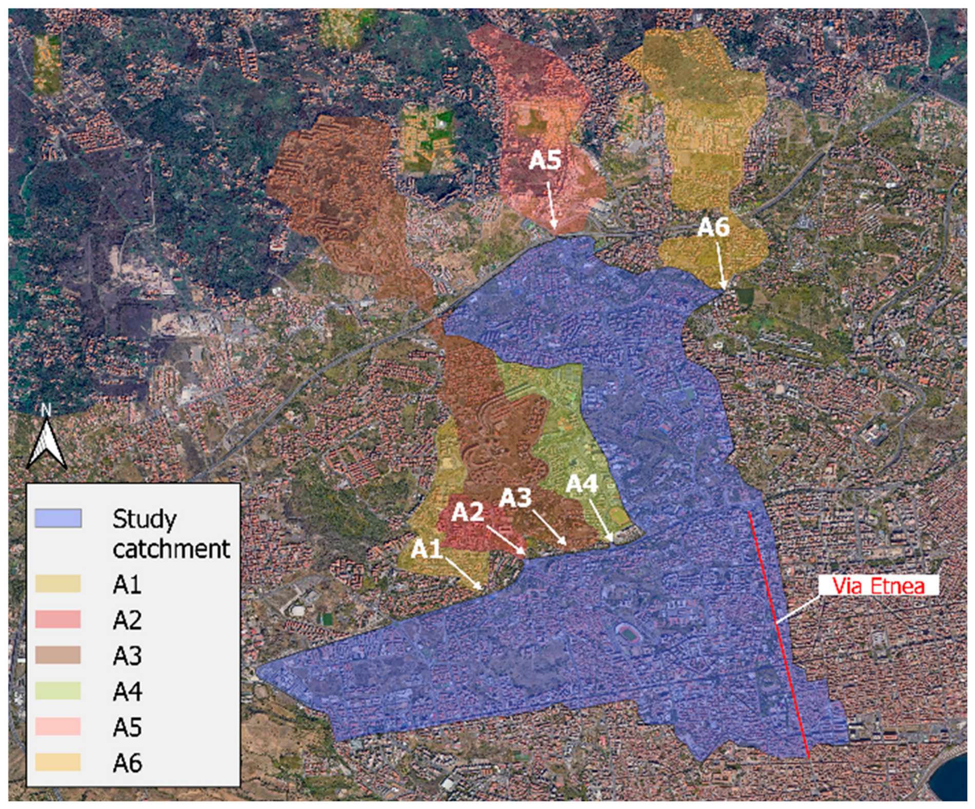
The methodology was applied to an 873-hectare urban catchment in the metropolitan area of Catania, southern Italy (
Figure 1). The area has experienced recurrent pluvial flooding, driven by its complex topography and the expansion of urbanized zones, particularly in upstream foothill areas. Limited sewer infrastructure in these external zones results in additional runoff contributions to the city during rainfall events, exacerbating flooding in the central districts. Six external contributing areas (A1 to A6 in
Figure 1) were identified as sources of additional inflow to the catchment.
4. Results
Fifteen parameter configurations were tested during calibration using the rainfall event of 19 October 2024. The configuration yielding the lowest RMSE for two of the three hydraulic variables was selected as optimal (
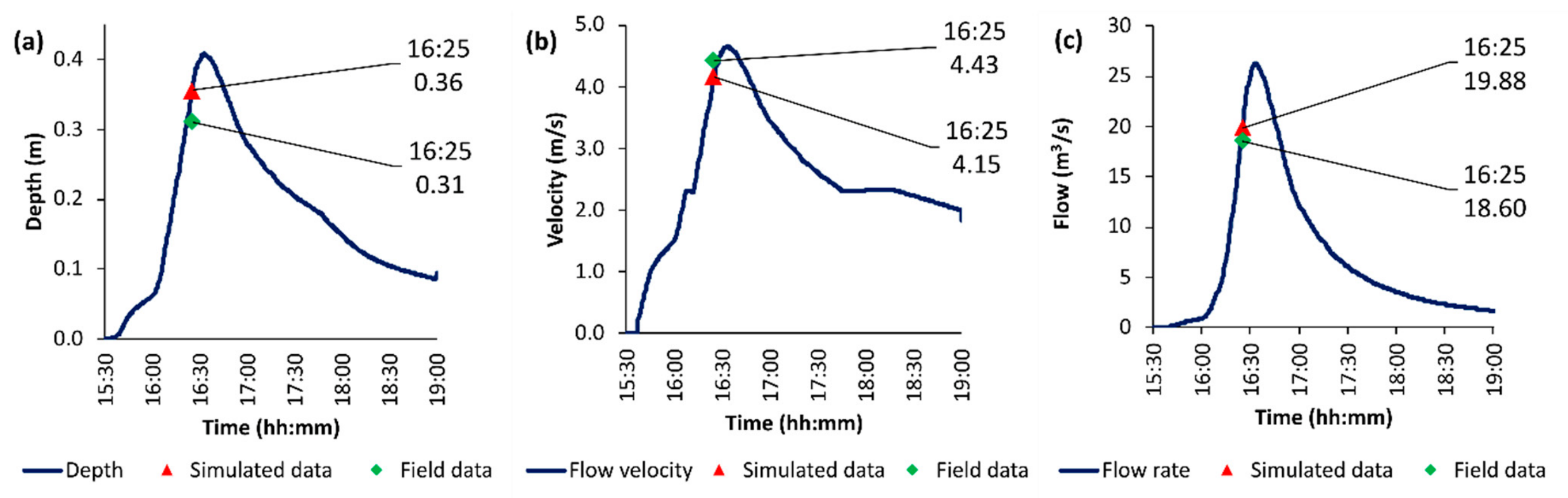
Table 1). Validation using the event of 21 February 2013 showed that the model slightly overestimated water depth and flow rate (
Figure 2a and
Figure 2c, respectively), while flow velocity was slightly underestimated (
Figure 2b). Nonetheless, the comparison between simulated and observed values demonstrated satisfactory agreement across both calibration and validation events.
5. Conclusions
This work presents a modelling strategy that incorporates a dynamic assessment of sewer capacity into the simulation of street-level surface flows during pluvial floods. By first quantifying the temporal evolution of sewer conveyance and then integrating this information into a street-flow model, the methodology provides a more realistic representation of flood dynamics. Application to a real urban catchment in southern Italy, supported by field measurements and video-based observations, confirmed the method’s reliability. Future developments may explore the use of multiple reduced hyetographs tailored to different sub-catchments with distinct sewer characteristics.
Author Contributions
Conceptualization, A.C.; methodology, A.G., L.B.-J. and A.C.; software, L.B.-J.; validation, L.B.-J.; formal analysis, A.G., L.B.-J. and A.C.; investigation, A.G. and L.B.-J.; data curation, L.B.-J.; writing—original draft preparation, L.B.-J.; writing—review and editing, A.G. and A.C.; visualization, L.B.-J.; supervision, A.G. and A.C. All authors have read and agreed to the published version of the manuscript.
Funding
This research received no external funding.
Data Availability Statement
Data presented in this study are available on request from the corresponding author.
Conflicts of Interest
The authors declare no conflicts of interest.
References
- Cea, L.; Costabile, P. Flood Risk in Urban Areas: Modelling, Management and Adaptation to Climate Change. A Review. Hydrology 2022, 9, 50. [Google Scholar] [CrossRef] [Scilit]
- Li, D.; Hou, J.; Zhang, Y.; Guo, M.; Zhang, D. Influence of time step synchronization on urban rainfall-runoff simulation in a hybrid CPU/GPU 1D-2D coupled model. Water Resour. Manag. 2022, 36, 3417–3433. [Google Scholar] [CrossRef] [Scilit]
- Oberauer, M.; Lehmann, B. Modifying 2D surface models in urban flood analysis. J. Hydrol. 2023, 625, 130063. [Google Scholar] [CrossRef] [Scilit]
- Henonin, J.; Russo, B.; Mark, O.; Gourbesville, P. Real-time urban flood forecasting and modelling—A state of the art. J. Hydroinform. 2013, 15, 717–736. [Google Scholar] [CrossRef] [Scilit]
- Montalvo, C.; Reyes-Silva, J.D.; Sañudo, E.; Cea, L.; Puertas, J. Urban pluvial flood modelling in the absence of sewer drainage network data: A physics-based approach. J. Hydrol. 2024, 634, 131043. [Google Scholar] [CrossRef] [Scilit]
- Rossman, L.A.; Simon, M.A. Storm Water Management Model User’s Manual Version 5.2; Center for Environmental Solutions and Emergency Response, Office of Research and Development, U.S. Environmental Protection Agency: Cincinnati, OH, USA, 2022. Available online: https://www.epa.gov/system/files/documents/2022-04/swmm-users-manual-version-5.2.pdf (accessed on 28 May 2026).
| Disclaimer/Publisher’s Note: The statements, opinions and data contained in all publications are solely those of the individual author(s) and contributor(s) and not of MDPI and/or the editor(s). MDPI and/or the editor(s) disclaim responsibility for any injury to people or property resulting from any ideas, methods, instructions or products referred to in the content. |