1. Introduction
Emerging 6G networks are evolving toward integrated terrestrial and non-terrestrial infrastructures, featuring multilayer architectures that enable communication, navigation, and sensing convergence. This integration supports ubiquitous coverage and efficient use of resources, creating opportunities for multipurpose satellite constellations. Concurrently, the commercial growth of LEO constellations has demonstrated their potential for global broadband services, while research explores their use for Positioning, Navigation, and Timing (PNT) applications. In Ref. [
1], optimal LEO constellation configurations capable of providing PNT services have been identified.
In this framework, multipurpose constellations offer operational efficiency by supporting multiple services with a single infrastructure, thereby reducing costs and enhancing space sustainability [
2]. However, designing such systems presents challenges, as communication and navigation requirements often conflict, particularly regarding latency and Geometric Dilution of Precision (GDOP). In single-layer architectures, lower orbital altitudes generally minimize latency, whereas higher altitudes improve GDOP. As a result, no single-layer constellation can simultaneously achieve optimal performance for both services.
This paper investigates whether multilayer architectures can achieve better trade-offs. Through a two-layer constellation study, we demonstrate that combining low- and high-altitude satellites simultaneously improves both latency and GDOP, highlighting the advantages of integrated designs.
The paper is organized as follows.
Section 2 introduces multipurpose constellations.
Section 3 reviews related works.
Section 4 presents the system model.
Section 5 formulates the optimization problem and presents the simulation results, and
Section 6 concludes with future research directions.
2. Multipurpose Constellations
Multipurpose constellations integrate diverse services, including communications, PNT, surveillance, and Earth observation, onto shared satellite platforms. This integrated approach improves system versatility while optimizing orbital resources.
The architecture relies on three principles: a multilayer design (LEO/MEO/GEO integration), distributed networking, and high-speed ISLs for routing and redundancy. LEO constellations provide low-latency global coverage with reduced delays and improved user access compared to GEO/MEO systems [
3], making them essential for next-generation networks facing growing broadband and IoT demands.
Multilayer constellations enable traffic-aware backhaul provisioning, reducing satellite counts while maintaining throughput. Positioning accuracy is another key objective, and the geometric diversity of satellites improves the precision of navigation services. When enhanced with ISLs, these networks support low-latency multi-hop routing while improving user positioning geometry [
4].
Motivated by these benefits, this paper jointly optimizes communication latency and positioning performance in multilayer LEO/MEO constellations with ISLs. We propose a genetic algorithm framework to optimize the number of satellites per plane, the number of planes, and inter-plane phase offsets, minimizing end-to-end latency and GDOP under coverage and satellite count constraints.
3. Related Works
In Ref. [
5], the authors introduced a multilayer staged deployment framework for satellite constellations that facilitates flexible, incremental expansion to accommodate uncertain global internet demand while simultaneously reducing overall deployment expenditures. A dual-layer satellite constellation with satellites at different altitudes and inclinations was proposed to improve coverage and reduce redundancy, determining the minimum number of satellites per orbit needed for continuous global coverage [
6,
7].
The study in Ref. [
8] examined the impact of inter-satellite links (ISLs) in dense LEO networks, showing how intra-orbital, adjacent, nearby, and crossing-plane ISLs can significantly enhance communication performance while also revealing how the maximum ISL distance reshapes network topology and latency.
In Ref. [
9], the authors investigated a traffic-aware multilayer LEO satellite-terrestrial network in which dense satellites provide high-capacity backhaul for terrestrial users. Using stochastic geometry and queueing theory, they analyzed the average backhaul capacity and proposed a multilayer constellation design that minimizes the number of satellites while ensuring seamless coverage.
The study in Ref. [
10] examined the rapid growth of non-geostationary satellite constellations and the growing importance of radio-frequency-based inter-satellite links (ISLs) for handling heterogeneous traffic, with a particular focus on large-scale constellations using massive numbers of ISLs.
4. System Model
Satellite positions and velocities are computed across all orbital shells using a two-body propagator with Keplerian orbital elements. This enables the analysis of network coverage and topological characteristics using relative and absolute motion parameters.
4.1. ISL Connection
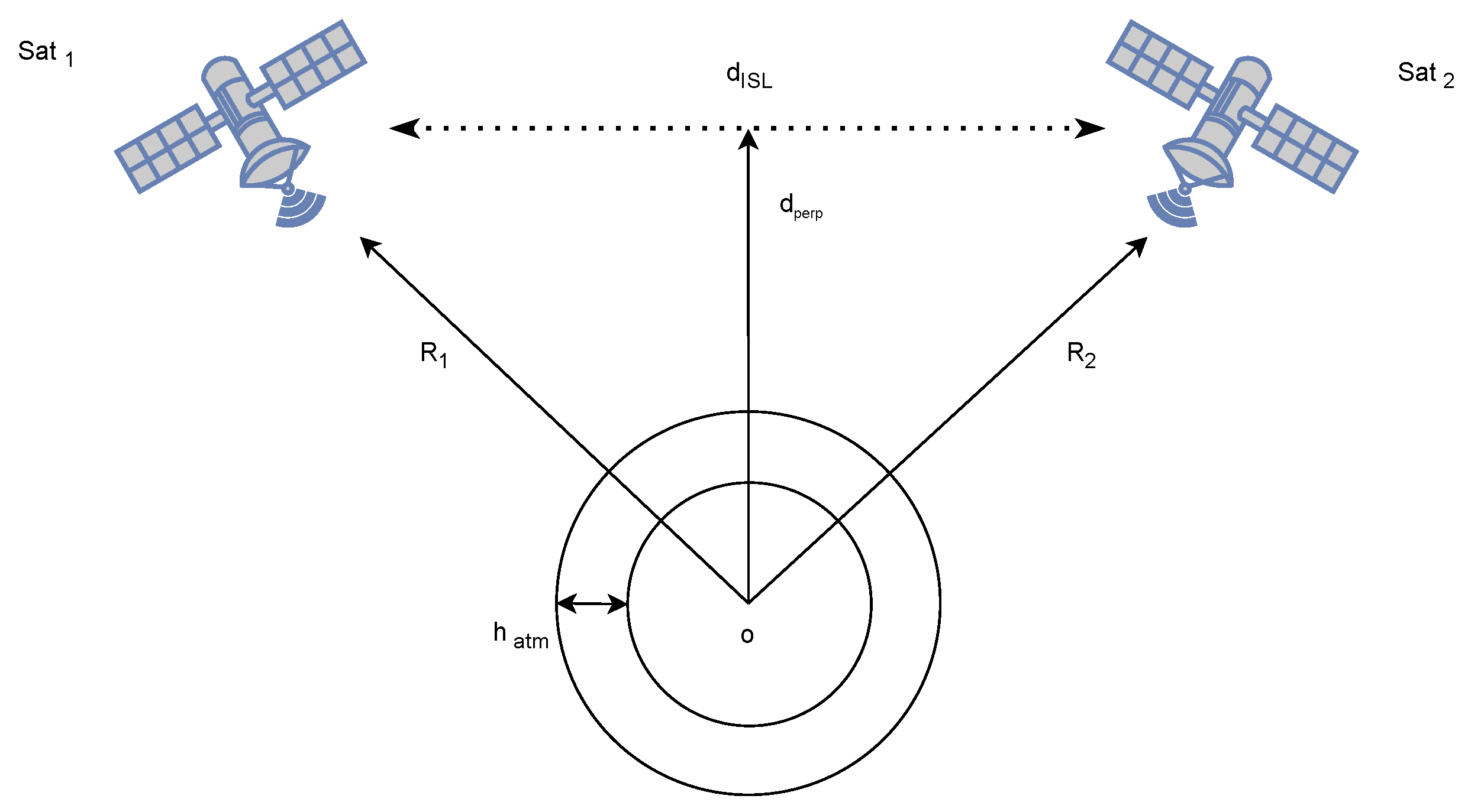
Figure 1 illustrates the inter-satellite link (ISL) geometry model, where
denotes the perpendicular distance from the Earth center to the ISL path,
is the Earth radius,
represents the atmospheric boundary height,
is the Doppler shift caused by the relative motion between satellites, and
is the distance between the two connected satellites. For an ISL between any two satellites to be established at a given snapshot, the following conditions must be simultaneously satisfied:
- 1.
ISLs require > to remain above the atmospheric boundary = 100 km.
- 2.
The Doppler shift must be below = 20 MHz (1% of the 2 GHz receiver bandwidth).
- 3.
The ISL distance = 3000 km, based on link budget constraints.
The above conditions can be mathematically expressed as
where
and
and
.
4.2. GDOP Analysis and Satellite Visibility
Geometric Dilution of Precision (GDOP) quantifies how satellite–receiver geometry affects positioning accuracy. Lower values indicate better satellite distribution and more reliable position estimates [
11].
The geometry matrix
is constructed using line-of-sight unit vectors from the receiver to each satellite:
where the unit vector components
are computed from the satellite and receiver coordinates.
GDOP is then calculated as
where
denotes the trace of a matrix.
GDOP (
) is evaluated only when a sufficient number of satellites are visible. Satellites above 10° elevation are considered visible; epochs with fewer than four visible satellites are discarded.
Table 1 [
1] categorizes GDOP quality.
4.3. Latency and Queuing Delay Evaluation
Network performance is characterized by end-to-end latency , including the queuing delay along the multi-hop ISL path.
Latency computation includes:
Overall latency: .
5. Satellite Constellation Design
Satellite constellation design ensures continuous global coverage through structured arrangements of altitude, orbital planes, and phasing. The scalable Walker Delta framework provides an analytically tractable method for distributing satellites across orbital planes [
13,
14].
A Walker constellation is defined by the three parameters , where N is the total number of satellites, p is the number of orbital planes, is the number of satellites per plane, and f is the inter-plane phasing factor. This configuration enables quasi-uniform global coverage through a systematic distribution of satellites.
5.1. Optimization Strategy
We investigate a multilayer constellation for global coverage and end-to-end communication. A genetic algorithm is used to optimize the number of satellites per plane, the number of planes, and phase offsets, evaluating each configuration based on combined communication latency and positioning accuracy metrics. Key simulation parameters are listed in
Table 2.
5.2. Parameter Selection for GA
The GA parameters in
Table 3 balance exploration and convergence. The population size and number of generations ensure a broad search, while crossover, mutation, and tournament selection maintain diversity. Convergence criteria terminate the optimization when improvements become negligible.
5.3. Objective Function Formulation
The GA uses the objective function
, penalizing infeasible configurations and simulating feasible ones to compute latency and GDOP. The optimization variables are
, representing satellites per plane, planes, and phase offsets for both layers:
This formulation ensures that the GA selects constellations that minimize latency and GDOP simultaneously.
5.4. Simulation Results
5.4.1. Scenario 1
The first scenario concerns the optimization of a two-layer satellite constellation with the parameters reported in
Table 2, considering the constraint
km. From the GA-optimized results shown in
Table 4, we observe that:
A higher number of satellites in the lower layer helps reduce latency but increases GDOP
A higher number of satellites in the upper layer leads to a better GDOP; latency increases, but at a much slower rate than GDOP.
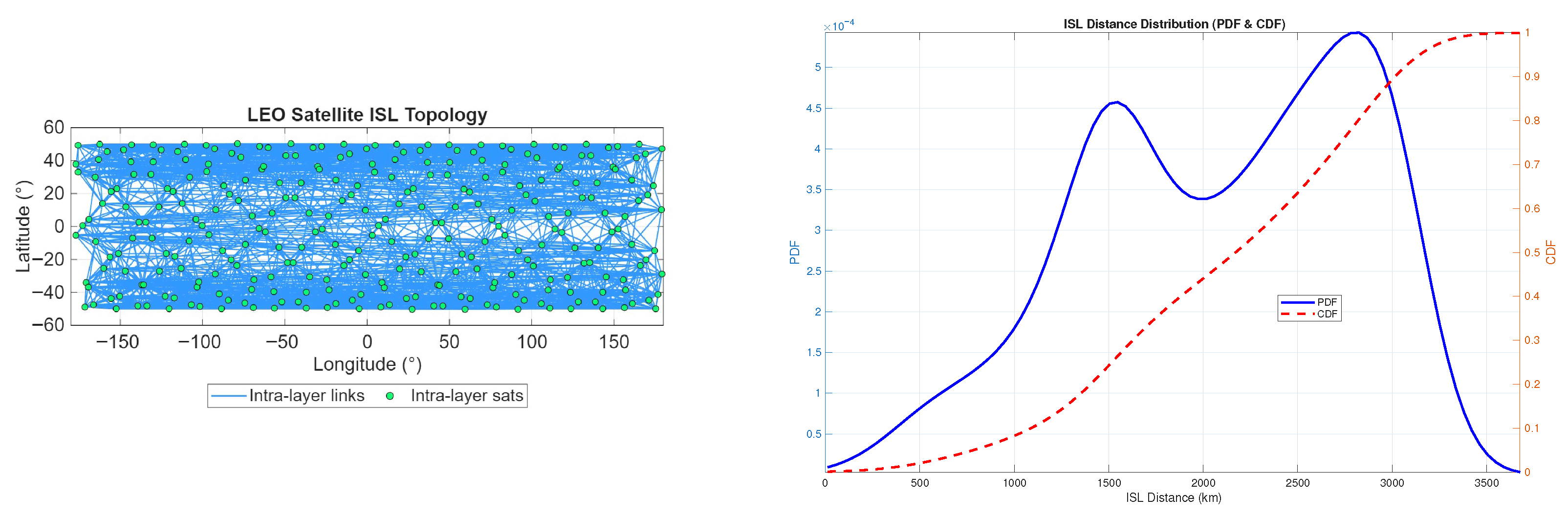
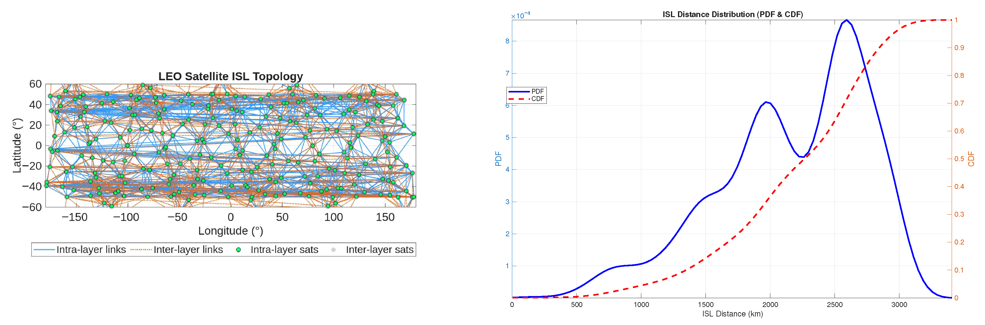
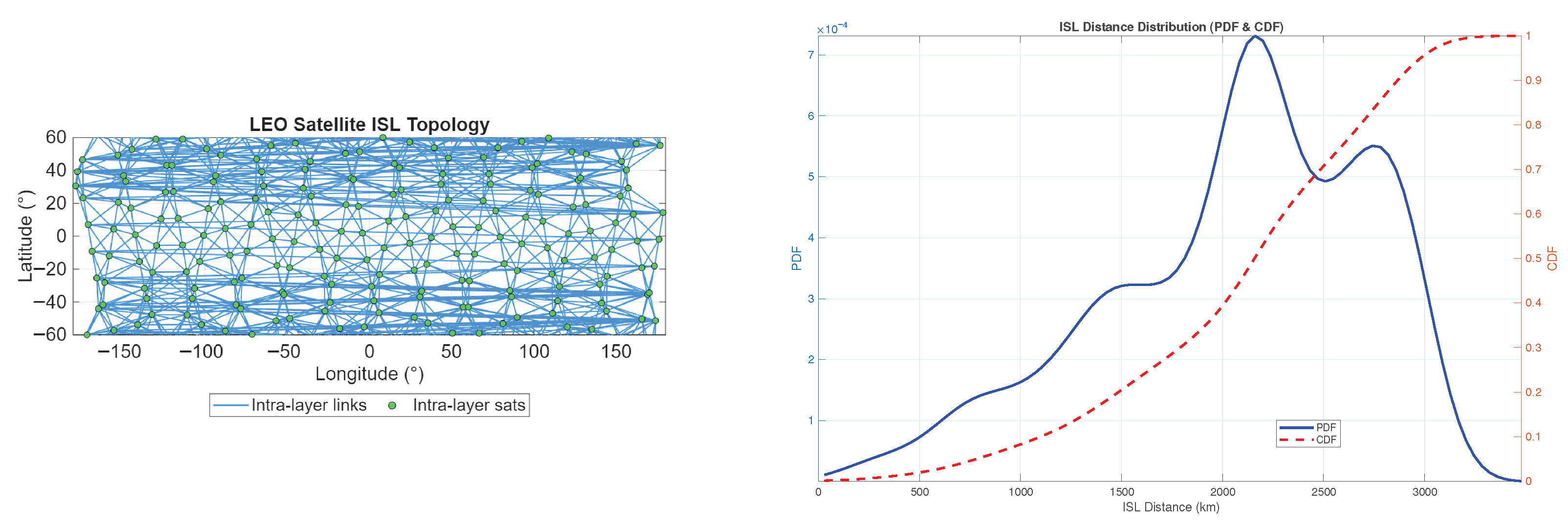
To better understand the impact of different satellite distributions in the two layers on latency, we derive the network topology and the Probability Density Function (PDF) and cumulative distribution function (CDF) of the ISL distances for different satellite distributions in the two layers, namely for the configurations referred to as Run 1, Run 5, and Run 11 in
Table 4. The results are shown in
Figure 2,
Figure 3 and
Figure 4. From
Figure 2,
Figure 3 and
Figure 4, it is clear that when most satellites are in the higher layer, the concentration of ISL distances shifts toward higher values. However, in
Figure 2, the probability of a high ISL distance is also relatively high. Thus, it can be expected that different satellite distributions have only a small impact on latency. Therefore, in the scenario considered, a good trade-off is achieved by placing most satellites in the upper layer, which minimizes GDOP with an acceptable increase in latency.
5.4.2. Scenario 2
The second scenario concerns the optimization of an IRIS
2 inspired two–layer satellite constellation with the parameters reported in
Table 2, considering the constraint
km.
Lower-layer dominance yields a high GDOP but low latency.
A greater number of upper-layer satellites improves GDOP significantly.
Fully upper-layer configurations increase latency substantially.
The balanced (0.5–0.5) architecture achieves the best trade-off, demonstrating that IRIS2-style constellations benefit from integrating both altitude layers rather than relying on a single LEO or MEO layer.
6. Conclusions
This paper presents a framework for jointly optimizing communication and positioning performance in multilayer satellite constellations. Using a composite objective function , we demonstrate that integrated design is essential for multipurpose networks. A genetic algorithm is used to optimize Walker constellation parameters—the number of satellites per plane, the number of planes, and inter-plane phasing—across two orbital layers under fixed satellite and ISL constraints.
Simulations for a dual-layer LEO constellation (600 km and 1200 km) reveal key trade-offs: lower-layer dominance minimizes latency but degrades GDOP, whereas an upper-layer emphasis improves GDOP at the expense of a moderate increase in latency. The best performance occurs with balanced or upper-skewed distributions, highlighting the limitations of single-layer designs.
An IRIS2-inspired scenario (1200 km and 8000 km) further underscores the value of architectural heterogeneity. While a pure MEO configuration provides superior GDOP, it suffers from high latency; balanced multilayer deployments offer the best overall trade-off. These findings confirm that the proposed GA-based approach effectively explores the design space for multilayer constellations, providing insights for future multipurpose satellite network development.
Author Contributions
Conceptualization and writing—review and editing, E.C.; methodology and writing—review and editing, M.D.S.; software, formal analysis, and writing—original draft preparation, M.J.; methodology and writing—review and editing, T.R. All authors have read and agreed to the published version of the manuscript.
Funding
This work was partially supported by the European Union’s NextGenerationEU under the Italian National Recovery and Resilience Plan (NRRP), Mission 4, Component 2, Investment 1.3 (CUP B83D22001190006), within the partnership on “Telecommunications of the Future” (PE00000001, program “RESTART”).
Institutional Review Board Statement
Not applicable.
Informed Consent Statement
Not applicable.
Data Availability Statement
The original contributions presented in this study are included in the article.
Conflicts of Interest
The authors declare no conflicts of interest.
Abbreviations
The following abbreviations are used in this manuscript:
| LEO | Low Earth Orbit |
| MEO | Medium Earth Orbit |
| GEO | Geostationary Earth Orbit |
| RAAN | Right Ascension of the Ascending Node |
| ISL | Inter Satellite Link |
| GDOP | Geometric Dilution of Precision |
| IoT | Internet of Things |
| GA | Genetic Algorithm |
| LOS | Line of Sight |
References
- More, H.; Gerardi, R.; Stallo, C.; De Sanctis, M.; Cianca, E. Pnt through optimised leo constellation and ins. In Proceedings of the Proceedings of the 35th International Technical Meeting of the Satellite Division of The Institute of Navigation (ION GNSS+ 2022), Denver, CO, USA, 19–23 September 2022; pp. 1428–1441. [Google Scholar]
- Cianca, E.; Rossi, T.; Ruggieri, M.; De Sanctis, M. Space Sustainability-By-Design: Challenges and Key-Enablers. IEEE Aerosp. Electron. Syst. Mag. 2025, 40, 4–17. [Google Scholar] [CrossRef]
- Qu, Z.; Zhang, G.; Cao, H.; Xie, J. LEO satellite constellation for Internet of Things. IEEE Access 2017, 5, 18391–18401. [Google Scholar] [CrossRef]
- Xu, X.; Wang, C.; Jin, Z. An analysis method for ISL of multilayer constellation. J. Syst. Eng. Electron. 2022, 33, 961–968. [Google Scholar] [CrossRef]
- Anderson, J.F.; Cardin, M.A.; Grogan, P.T. Design and analysis of flexible multi-layer staged deployment for satellite mega-constellations under demand uncertainty. Acta Astronaut. 2022, 198, 179–193. [Google Scholar] [CrossRef]
- Zhao, X.; Wang, C.; Cai, S.; Wang, W. Cooperative Design of Dual-Layer LEO Satellite Constellation Based on Diversified QoS Requirements and Seamless Multi-Coverage. IEEE Trans. Veh. Technol. 2025, 74, 925–939. [Google Scholar] [CrossRef]
- Ruan, Y.; Hu, M.; Xue, W.; Guo, W. Design of Hybrid Dual-Layer Communication Constellation for Low Earth Orbit with Regenerative Orbits. In Proceedings of the 2024 7th International Conference on Mechatronics and Computer Technology Engineering (MCTE); IEEE: New York, NY, USA, 2024; pp. 907–914. [Google Scholar]
- Sanctis, M.D.; Cianca, E.; Rossi, T.; More, H. RF ISLs in LEO Mega-Constellations-Network Topology and Latency. In Proceedings of the 2025 IEEE 12th International Workshop on Metrology for AeroSpace (MetroAeroSpace); IEEE: New York, NY, USA, 2025; pp. 251–255. [Google Scholar] [CrossRef]
- Wang, P.; Di, B.; Song, L. Multi-layer LEO satellite constellation design for seamless global coverage. In Proceedings of the 2021 IEEE Global Communications Conference (GLOBECOM); IEEE: New York, NY, USA, 2021; pp. 01–06. [Google Scholar]
- Kisseleff, S.; Baeza, V.M.; Al-Hraishawi, H.; Ntontin, K.; Martins, W.A.; Chatzinotas, S. Massive RF Inter-Satellite Links for Massive Non-Terrestrial Networks. IEEE Commun. Mag. 2025, 63, 48–53. [Google Scholar] [CrossRef]
- Kaplan, E.D.; Hegarty, C. Understanding GPS/GNSS: Principles and Applications; Artech House: Norwood, MA, USA, 2017. [Google Scholar]
- Marcano, N.J.H.; Diez, L.; Calvo, R.A.; Jacobsen, R.H. On the queuing delay of time-varying channels in low earth orbit satellite constellations. IEEE Access 2021, 9, 87378–87390. [Google Scholar] [CrossRef]
- Deng, Z.; Ge, W.; Yin, L.; Dai, S. Optimization design of two-layer Walker constellation for LEO navigation augmentation using a dynamic multi-objective differential evolutionary algorithm based on elite guidance. GPS Solut. 2023, 27, 26. [Google Scholar] [CrossRef] [PubMed]
- Guan, M.; Xu, T.; Gao, F.; Nie, W.; Yang, H. Optimal walker constellation design of LEO-based global navigation and augmentation system. Remote Sens. 2020, 12, 1845. [Google Scholar] [CrossRef]
| Disclaimer/Publisher’s Note: The statements, opinions and data contained in all publications are solely those of the individual author(s) and contributor(s) and not of MDPI and/or the editor(s). MDPI and/or the editor(s) disclaim responsibility for any injury to people or property resulting from any ideas, methods, instructions or products referred to in the content. |