Multicriteria GIS-Based Approach in Priority Areas Analysis for Sustainable Urban Drainage Practices: A Case Study of Pato Branco, Brazil
Abstract
1. Introduction
2. Materials and Methods
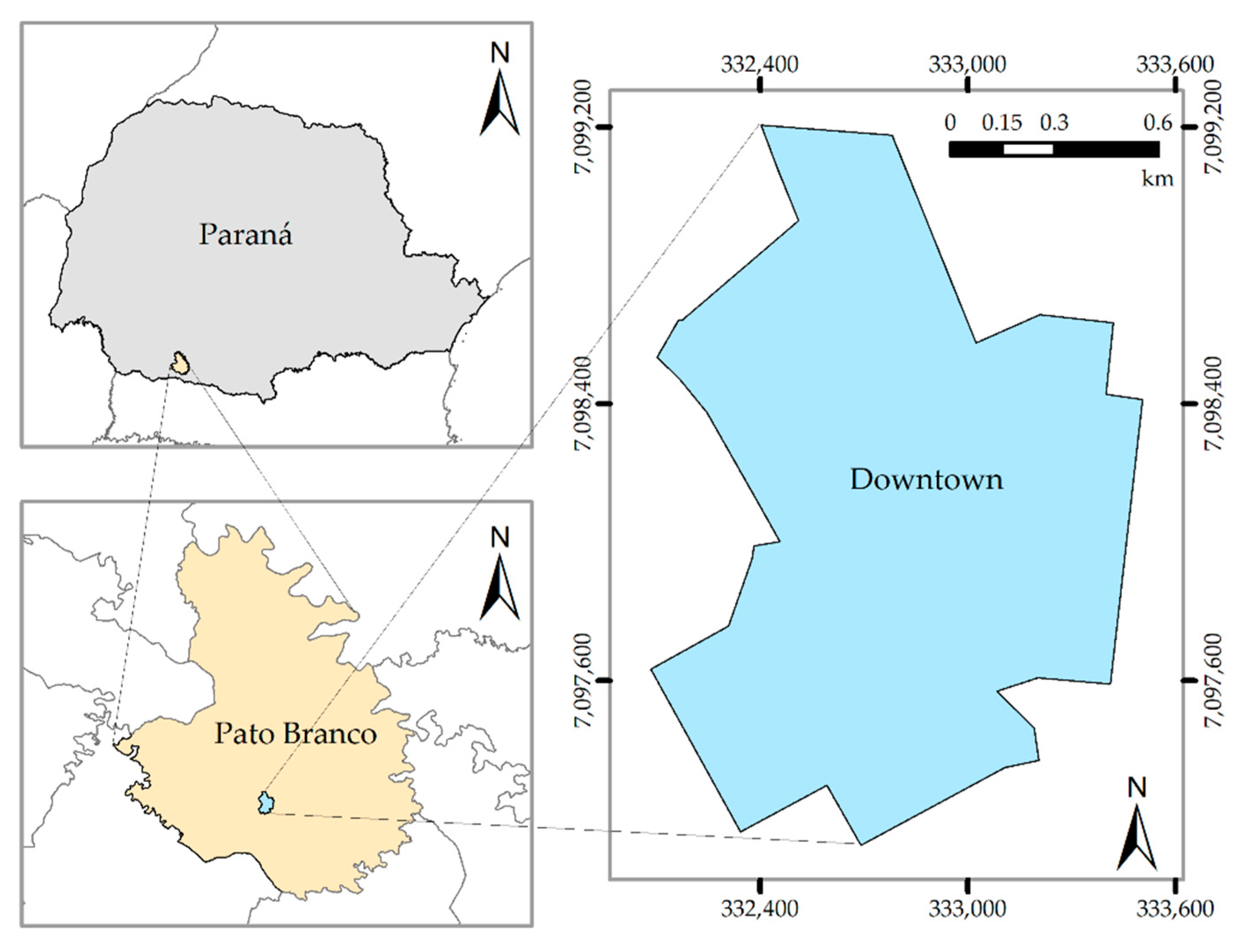
2.1. Study Area
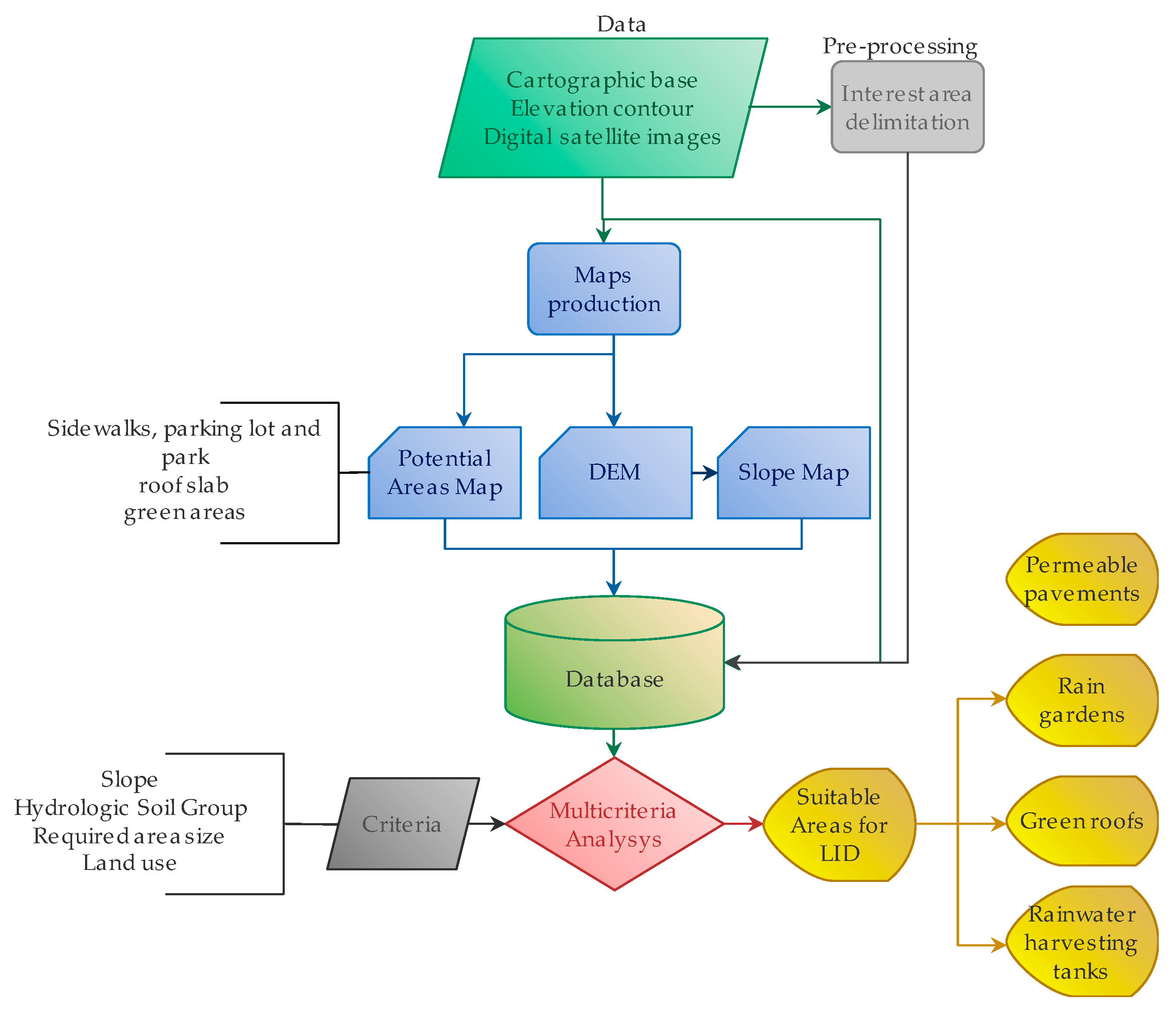
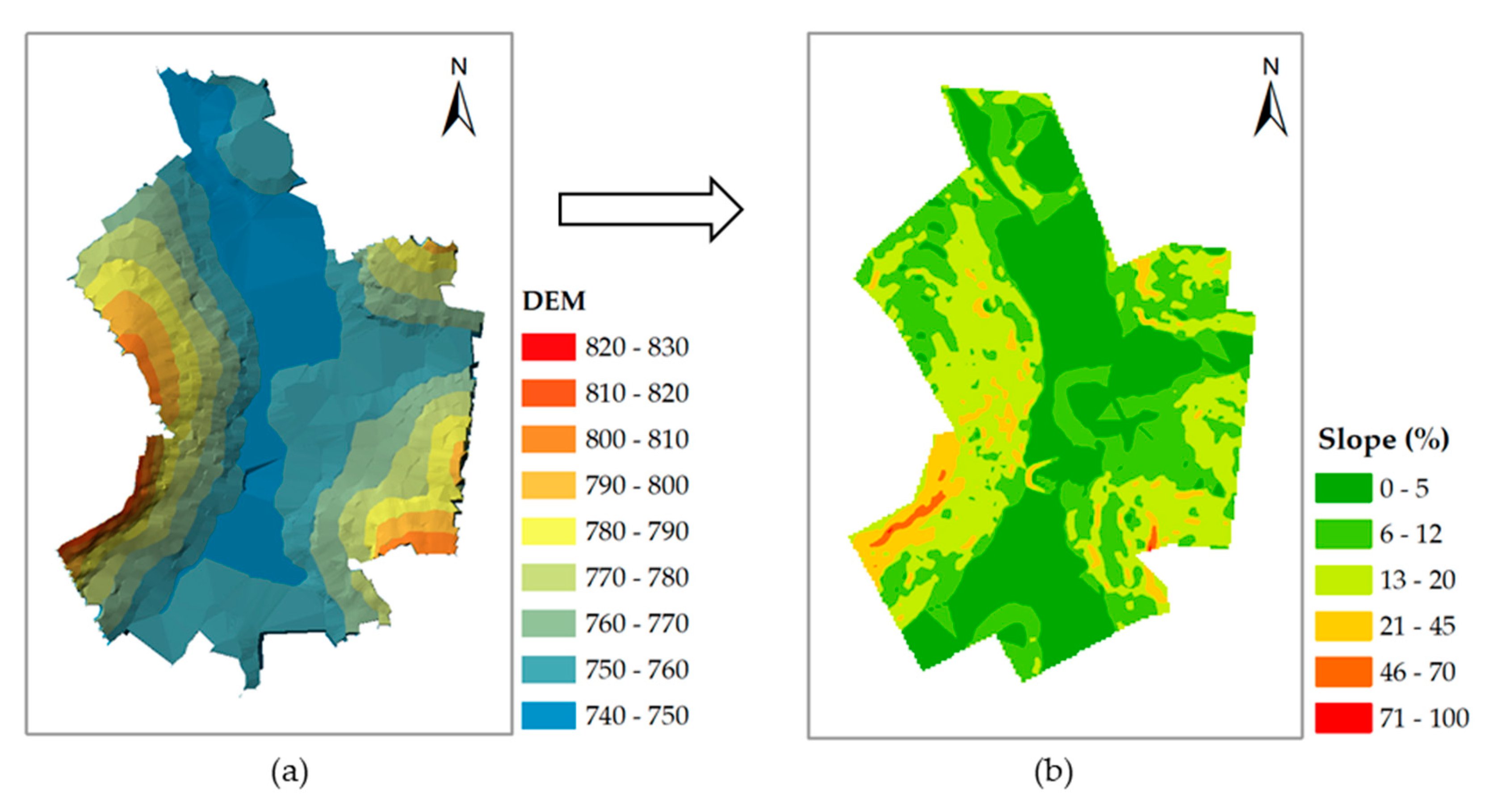
2.2. Identification of Potential Areas
2.3. Identification of Conditions for the Implementation of LIDs
2.4. Multicriteria Analysis
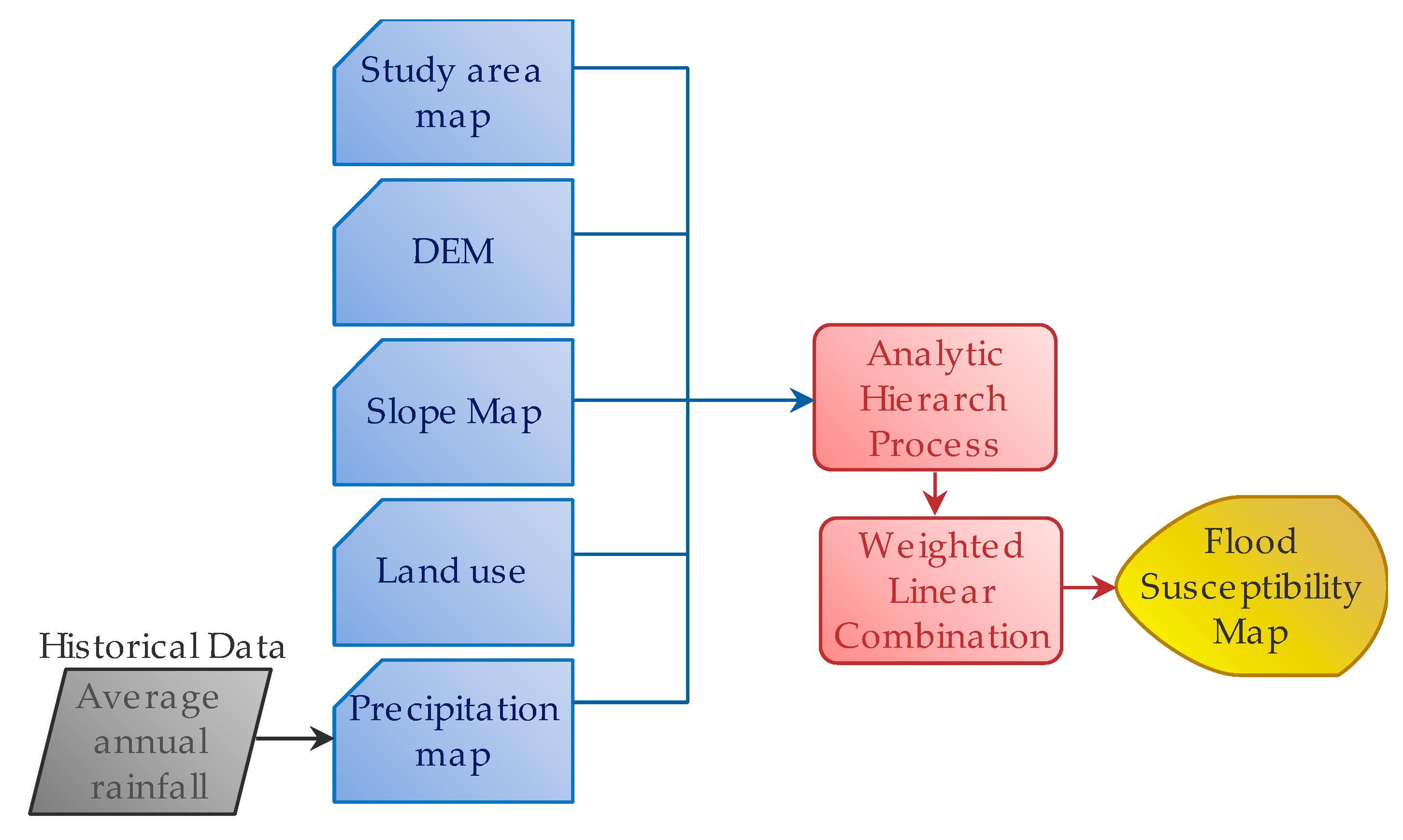
2.5. Flood Susceptibility Map
3. Results and Discussion
4. Conclusions
Author Contributions
Funding
Conflicts of Interest
References
- Huang, J.; He, J.X.; Valeo, C.; Chu, A. Temporal evolution modeling of hydraulic and water quality performance of permeable pavements. J. Hydrol. 2016, 533, 15–27. [Google Scholar] [CrossRef]
- Hou, J.M.; Zhang, Y.W.; Tong, Y.; Guo, K.H.; Qi, W.C.; Hinkelmann, R. Experimental study for effects of terrain features and rainfall intensity on infiltration rate of modelled permeable pavement. J. Environ. Manag. 2019, 243, 177–186. [Google Scholar] [CrossRef]
- Su, W.Z.; Duan, H.T. Catchment-based imperviousness metrics impacts on floods in Niushou River basin, Nanjing City, East China. Chin. Geogr. Sci. 2017, 27, 229–238. [Google Scholar] [CrossRef]
- Talib, A.; Randhir, T.O. Climate change and land use impacts on hydrologic processes of watershed systems. J. Water Clim. Chang. 2017, 8, 363–374. [Google Scholar] [CrossRef]
- Yin, J.B.; Gentine, P.; Zhou, S.; Sullivan, S.C.; Wang, R.; Zhang, Y.; Guo, S.L. Large increase in global storm runoff extremes driven by climate and anthropogenic changes. Nat. Commun. 2018, 9, 1034–1050. [Google Scholar] [CrossRef] [PubMed]
- Wang, H.; Mei, C.; Liu, J.H.; Shao, W.W. A new strategy for integrated urban water management in China: Sponge city. Sci. China Technol. Sci. 2018, 61, 317–329. [Google Scholar] [CrossRef]
- Erickson, T.; Stefan, H. Natural Groundwater Recharge Response to Urbanization: Vermillion River Watershed, Minnesota. J. Water Resour. Plan. Manag. 2009, 135, 512–520. [Google Scholar] [CrossRef]
- Dilley, M.; Chen, R.S.; Deichmann, U.; Lerner-Lam, A.L.; Arnold, M. Natural disaster hotspots: A global risk analysis. World Bank 2005, 1, 145. [Google Scholar]
- Kotzee, I.; Reyers, B. Piloting a social-ecological index for measuring flood resilience: A composite index approach. Ecol. Indic. 2016, 60, 45–53. [Google Scholar] [CrossRef]
- Khajehei, S.; Ahmadalipour, A.; Shao, W.Y.; Moradkhani, H. A Place-based Assessment of Flash Flood Hazard and Vulnerability in the Contiguous United States. Sci. Rep. 2020, 10. [Google Scholar] [CrossRef]
- Spitalar, M.; Gourley, J.J.; Lutoff, C.; Kirstetter, P.E.; Brilly, M.; Carr, N. Analysis of flash flood parameters and human impacts in the US from 2006 to 2012. J. Hydrol. 2014, 519, 863–870. [Google Scholar] [CrossRef]
- Yu, H.F.; Zhao, Y.L.; Fu, Y.C.; Li, L. Spatiotemporal Variance Assessment of Urban Rainstorm Waterlogging Affected by Impervious Surface Expansion: A Case Study of Guangzhou, China. Sustainability 2018, 10, 3761. [Google Scholar] [CrossRef]
- Aroca-Jiménez, E.; Bodoque, J.M.; Garcia, J.A.; Diez-Herrero, A. A quantitative methodology for the assessment of the regional economic vulnerability to flash floods. J. Hydrol. 2018, 565, 386–399. [Google Scholar] [CrossRef]
- Arnell, N.W.; Gosling, S.N. The impacts of climate change on river flood risk at the global scale. Clim. Chang. 2016, 134, 387–401. [Google Scholar] [CrossRef]
- Nikulin, G.; Kjellstrom, E.; Hansson, U.; Strandberg, G.; Ullerstig, A. Evaluation and future projections of temperature, precipitation and wind extremes over Europe in an ensemble of regional climate simulations. Tellus Ser. A Dyn. Meteorol. Oceanogr. 2011, 63, 41–55. [Google Scholar] [CrossRef]
- IPCC. Climate Change 2014 Part A: Global and Sectoral Aspects; Cambridge University Press: Cambridge, UK, 2014. [Google Scholar]
- Shehata, M.; Mizunaga, H. Flash Flood Risk Assessment for Kyushu Island, Japan. Environ. Earth Sci. 2018, 77. [Google Scholar] [CrossRef]
- Creutin, J.D.; Borga, M. Radar hydrology modifies the monitoring of flash-flood hazard. Hydrol. Process. 2003, 17, 1453–1456. [Google Scholar] [CrossRef]
- Mitchell, V.G. Applying integrated urban water management concepts: A review of Australian experience. Environ. Manag. 2006, 37, 589–605. [Google Scholar] [CrossRef]
- Qiu, Y.; Ichiba, A.; Paz, I.S.R.; Chen, F.; Versini, P.A.; Schertzer, D.; Tchiguirinskaia, I. Evaluation of Low Impact Development and Nature-Based Solutions for stormwater management: A fully distributed modelling approach. Hydrol. Earth Syst. Sci. Discuss. 2019. [Google Scholar] [CrossRef]
- Li, C.; Peng, C.; Chiang, P.; Cai, Y.; Wang, X.; Yang, Z. Mechanisms and Applications of Green Infrastructure Practices for Stormwater Control: A Review. J. Hydrol. 2018, 568, 626–637. [Google Scholar] [CrossRef]
- Shuster, W.; Rhea, L. Catchment-scale hydrologic implications of parcel-level stormwater management (Ohio USA). J. Hydrol. 2013, 485, 177–187. [Google Scholar] [CrossRef]
- Burns, M.J.; Fletcher, T.D.; Walsh, C.J.; Ladson, A.R.; Hatt, B.E. Hydrologic shortcomings of conventional urban stormwater management and opportunities for reform. Landsc. Urban Plan. 2012, 105, 230–240. [Google Scholar] [CrossRef]
- Schueler, T.; Hirschman, D.; Novotney, M.; Zielinski, J. Urban Subwatershed Restoration Manual No. 3: Urban Stormwater Retrofit Practices; Center for Watershed Protection: Washington, DC, USA, 2007; Volume 3, 262p. [Google Scholar]
- Hellmers, S.; Manojlovic, N.; Palmaricciotti, G.; Frohle, P. Modelling decentralised systems for urban drainage and flood mitigation. J. Appl. Water Eng. Res. 2017, 5, 61–69. [Google Scholar] [CrossRef]
- Zhou, Q.Q. A review of sustainable urban drainage systems considering the climate change and urbanization impacts. Water 2014, 6, 976–992. [Google Scholar] [CrossRef]
- Stovin, V.; Vesuviano, G.; Kasmin, H. The hydrological performance of a green roof test bed under UK climatic conditions. J. Hydrol. 2012, 414, 148–161. [Google Scholar] [CrossRef]
- Ahiablame, L.M.; Engel, B.A.; Chaubey, I. Effectiveness of low impact development practices: Literature review and suggestions for future research. Water Air Soil Pollut. 2012, 223, 4253–4273. [Google Scholar] [CrossRef]
- Zhang, K.; Chui, T.F.M. A comprehensive review of spatial allocation of LID-BMP-GI practices: Strategies and optimization tools. Sci. Total Environ. 2018, 621, 915–929. [Google Scholar] [CrossRef]
- Razzaghmanesh, M.; Borst, M. Monitoring the performance of urban green infrastructure using a tensiometer approach. Sci. Total Environ. 2019, 651, 2535–2545. [Google Scholar] [CrossRef]
- Rodriguez-Rojas, M.I.; Huertas-Fernández, F.; Moreno, B.; Martínez, G.; Grindlay, A.L. A study of the application of permeable pavements as a sustainable technique for the mitigation of soil sealing in cities: A case study in the south of spain. J. Environ. Manag. 2018, 205, 151–162. [Google Scholar] [CrossRef]
- Brown, R.A.; Borst, M. Quantifying evaporation in a permeable pavement system. Hydrol. Process. 2015, 29, 2100–2111. [Google Scholar] [CrossRef]
- Beaupre, D.; Jencks, R.; Minick, S.; Mundy, J.; Navarret, A. Appendix A: BMP Fact Sheets. In San Francisco Stormwater Design Guidelines; San Francisco Public Utilities Commission: San Francisco, CA, USA, 2010; 120p. [Google Scholar]
- Stander, E.K.; Rowe, A.A.; Borst, M.; O’Connor, T.P. Novel Use of Time Domain Reflectometry in Infiltration-Based Low Impact Development Practices. J. Irrig. Drain. Eng. 2013, 139, 625–634. [Google Scholar] [CrossRef]
- Ávila, H.; Amaris, G.; Buelvas, J. Identifying Potential Areas for SUDS Application in Consolidated Urban Watersheds Based on GIS. In Water, Wastewater, and Stormwater and Urban Watershed Symposium; American Society of Civil Engineers: Reston, VA, USA, 2016; pp. 106–114. [Google Scholar]
- Christman, Z.; Meenar, M.; Mandarano, L.; Hearing, K. Prioritizing Suitable Locations for Green Stormwater Infrastructure Based on Social Factors in Philadelphia. Land 2018, 7, 145. [Google Scholar] [CrossRef]
- Carter, T.; Jackson, C.R. Vegetated roofs for stormwater management at multiple spatial scales. Landsc. Urban Plan. 2007, 80, 84–94. [Google Scholar] [CrossRef]
- Ballard, B.W.; Wilson, S.; Udale-Clarke, H.; Illman, S.; Scott, T.; Ashley, R.; Kellagher, R. The SuDS Manual; CIRIA: London, UK, 2015; 940p, ISBN 978-0-86017-760-9. [Google Scholar]
- Campisano, A.; Butler, D.; Ward, S.; Burns, M.J.; Friedler, E.; DeBusk, K.; Fisher-Jeffes, L.N.; Ghisi, E.; Rahman, A.; Furumai, H.; et al. Urban rainwater harvesting systems: Research, implementation and future perspectives. Water Res. 2017, 115, 195–209. [Google Scholar] [CrossRef] [PubMed]
- Ristic, V.; Maksin, M.; Nenković-Riznić, M.; Basarić, J. Land-use evaluation for sustainable construction in a protected area: A case of Sara mountain national park Vladica Risti. J. Environ. Manag. 2018, 206, 430–445. [Google Scholar] [CrossRef]
- Shariat, R.; Roozbahani, A.; Ebrahimin, A. Risk analysis of urban stormwater infrastructure systems using fuzzy spatial multi-criteria decision making. Sci. Total Environ. 2019, 647, 1468–1477. [Google Scholar] [CrossRef]
- Inamdar, P.M.; Sharma, A.K.; Cook, S.; Perera, B.J.C. Evaluation of Stormwater Harvesting Sites Using Multi Criteria Decision Methodology. J. Hydrol. 2018, 562, 181–192. [Google Scholar] [CrossRef]
- Ariza, S.L.J.; Martínez, J.A.; Muñoz, A.F.; Quijano, J.P.; Rodriguez, J.P.; Camacho, L.A.; Diaz-Granados, M. A Multicriteria Planning Framework to Locate and Select Sustainable Urban Drainage Systems (SUDS) in Consolidated Urban Areas. Sustainability 2019, 11, 2312. [Google Scholar] [CrossRef]
- Ahiablame, L.M.; Engel, B.A.; Chaubey, I. Effectiveness of low impact development practices in two urbanized watersheds: Retrofitting with rain barrel/cistern and porous pavement. J. Environ. Manag. 2013, 119, 151–161. [Google Scholar] [CrossRef]
- Wright, T.J.; Liu, Y.; Carroll, N.J.; Ahiablame, L.M.; Engel, B.A. Retrofitting LID practices into existing neighborhoods: Is it worth it? Environ. Manag. 2016, 57, 856–867. [Google Scholar] [CrossRef]
- Hu, M.; Zhang, X.; Li, Y.; Yang, H.; Tanaka, K. Flood mitigation performance of low impact development technologies under different storms for retrofitting an urbanized area. J. Clean. Prod. 2019, 222, 373–380. [Google Scholar] [CrossRef]
- Guo, X.; Du, P.; Zhao, D.; Li, M. Modelling low impact development in watersheds using the storm water management model. Urban Water J. 2019, 16, 146–155. [Google Scholar] [CrossRef]
- Qin, H.; Li, Z.; Fu, G. The effects of low impact development on urban flooding under different rainfall characteristics. J. Environ. Manag. 2013, 129, 577–585. [Google Scholar] [CrossRef] [PubMed]
- Eckart, K.; Mcphee, Z.; Bolisetti, T. Performance and implementation of low impact development—A review. Sci. Total Environ. 2017, 607, 413–432. [Google Scholar] [CrossRef] [PubMed]
- IBGE. Censo Demográfico. 2020. Available online: www.ibge.gov.br (accessed on 6 August 2020).
- Hutchinson, M.F. A new procedure for gridding elevation and streamline data with automatic removal of spurious pits. J. Hydrol. 1989, 106, 211–232. [Google Scholar] [CrossRef]
- Curebal, I.; Efe, R.; Ozdemir, H.; Soykan, A.; Sönmez, S. GIS-based approach for flood analysis: Case study of Keçidere flash flood event (Turkey). Geocarto Int. 2016, 31, 355–366. [Google Scholar] [CrossRef]
- Salekin, S.; Burgess, J.H.; Morgenroth, J.; Mason, E.G.; Meason, D.F. A Comparative Study of Three Non-Geostatistical Methods for Optimising Digital Elevation Model Interpolation. ISPRS Int. J. Geo-Inf. 2018, 7, 300. [Google Scholar] [CrossRef]
- Burrough, P.A.; McDonell, R.A.; Lloyd, C.D. Principles of Geographical Information Systems; Oxford University Press: Oxford, UK, 1998; 352p, ISSN 1567-5777. [Google Scholar]
- Department of Environemental Services. Storm Water Best Management Practice Manual; City and County of Honolulu: Kapolei, HI, USA, 2012.
- Los Angeles. Planning and Land Development Handbook for Low Impact Development (LID); City of Los Angeles: Los Angeles, CA, USA, 2016; Volume 5, 55p. [Google Scholar]
- PSP. Low Impact Development Technical Guidance Manual; Washington State University: Pullman, WA, USA, 2012; p. 346. [Google Scholar]
- Luo, X.Q.; Zhang, Z.C.; Wu, X.J. A novel algorithm of remote sensing image fusion based on shift-invariant Shearlet transform and regional selection. Int. J. Electron. Commun. 2016, 70, 186–197. [Google Scholar] [CrossRef]
- Zadeh, L.A. Fussy sets. Inf. Control 1965, 8, 338–353. [Google Scholar] [CrossRef]
- Asakereh, A.; Soleymani, M.; Sheikhdavoodi, M.J. A GIS-based Fuzzy-AHP method for the evaluation of solar farms locations: Case study in Khuzestan province, Iran. Sol. Energy 2017, 155, 342–353. [Google Scholar] [CrossRef]
- Chang, N.B.; Parvathinathan, G.; Breeden, J.B. Combining GIS with fuzzy multicriteria decision-making for landfill siting in a fast-growing urban region. J. Environ. Manag. 2008, 87, 139–153. [Google Scholar] [CrossRef] [PubMed]
- Ou, G.L.; Tan, S.K.; Zhou, M.; Lu, S.S.; Tao, Y.H.; Zhang, Z.; Zhang, L.; Yan, D.P.; Guan, X.L.; Wu, G. An interval chance-constrained fuzzy modeling approach for supporting land-use planning and eco-environment planning at a watershed level. J. Environ. Manag. 2017, 204, 651–666. [Google Scholar] [CrossRef] [PubMed]
- Saaty, R.W. The analytic hierarchy process-what it is and how it is used. Math. Model. 1987, 9, 161–176. [Google Scholar] [CrossRef]
- Biluca, J.; Aguiar, C.R.; Trojan, F. Sorting of suitable areas for disposal of construction and demolition waste using GIS and ELECTRE TRI. Waste Manag. 2020, 114, 307–320. [Google Scholar] [CrossRef]
- Melville-Shreeve, P.; Cotterill, S.; Grant, L.; Arahuetes, A.; Stovin, V.; Farmani, R.; Butler, D. State of SuDS delivery in the United Kingdom. Water Environ. J. 2018, 32, 9–16. [Google Scholar] [CrossRef]
- Jato-Espino, D.; Sillanpää, N.; Charlesworth, S.M.; Andrés-Doménech, I. Coupling GIS with Stormwater Modelling for the Location Prioritization and Hydrological Simulation of Permeable Pavements in Urban Catchments. Water 2016, 8, 451. [Google Scholar] [CrossRef]
- Hager, J.; Hu, G.H.; Hewage, K.; Sadiq, R. Performance of low-impact development best management practices: A critical review. Environ. Rev. 2019, 27, 17–42. [Google Scholar] [CrossRef]
- Steffen, J.; Jensen, M.; Pomeroy, C.A.; Burian, S.J. Water supply and stormwater management benefits of residential rainwater harvesting in U.S. cities. J. Am. Water Resour. Assoc. 2013, 49, 810–824. [Google Scholar] [CrossRef]
- Domènech, L.; Saurí, D. A comparative appraisal of the use of rainwater harvesting in single and multifamily buildings of the Metropolitan Area of Barcelona (Spain): Social experience, drinking water savings and economic costs. J. Clean. Prod. 2011, 19, 598–608. [Google Scholar] [CrossRef]
- Abi Aad, M.P.; Suidan, M.T.; Shuster, W.D. Modeling Techniques of Best Management Practices: Rain Barrels and Rain Gardens Using EPA SWMM-5. J. Hydrol. Eng. 2009, 15. [Google Scholar] [CrossRef]
- Baptista, M.B.; Nascimento, N.O. Aspectos Institucionais e de Financiamento dos Sistemas de Drenagem Urbana. Revista Brasileira de Recursos Hídricos 2016, 7, 29–49. [Google Scholar] [CrossRef]
- Visitacion, B.V.; Booth, D.B.; Steinemann, A.C. Costs and benefits of storm-water management: Case study of the Puget Sound Region. J. Urban Plan. Dev. 2009, 135, 150–158. [Google Scholar] [CrossRef]
- Marsalek, J.; Schereier, H. Innovation in stormwater management in Canada: The way forward. Water Qual. Res. J. Can. 2009, 44. [Google Scholar] [CrossRef]
- Trenberth, K.E. Changes in precipitation with climate change. Clim. Res. 2011, 47, 123–138. [Google Scholar] [CrossRef]
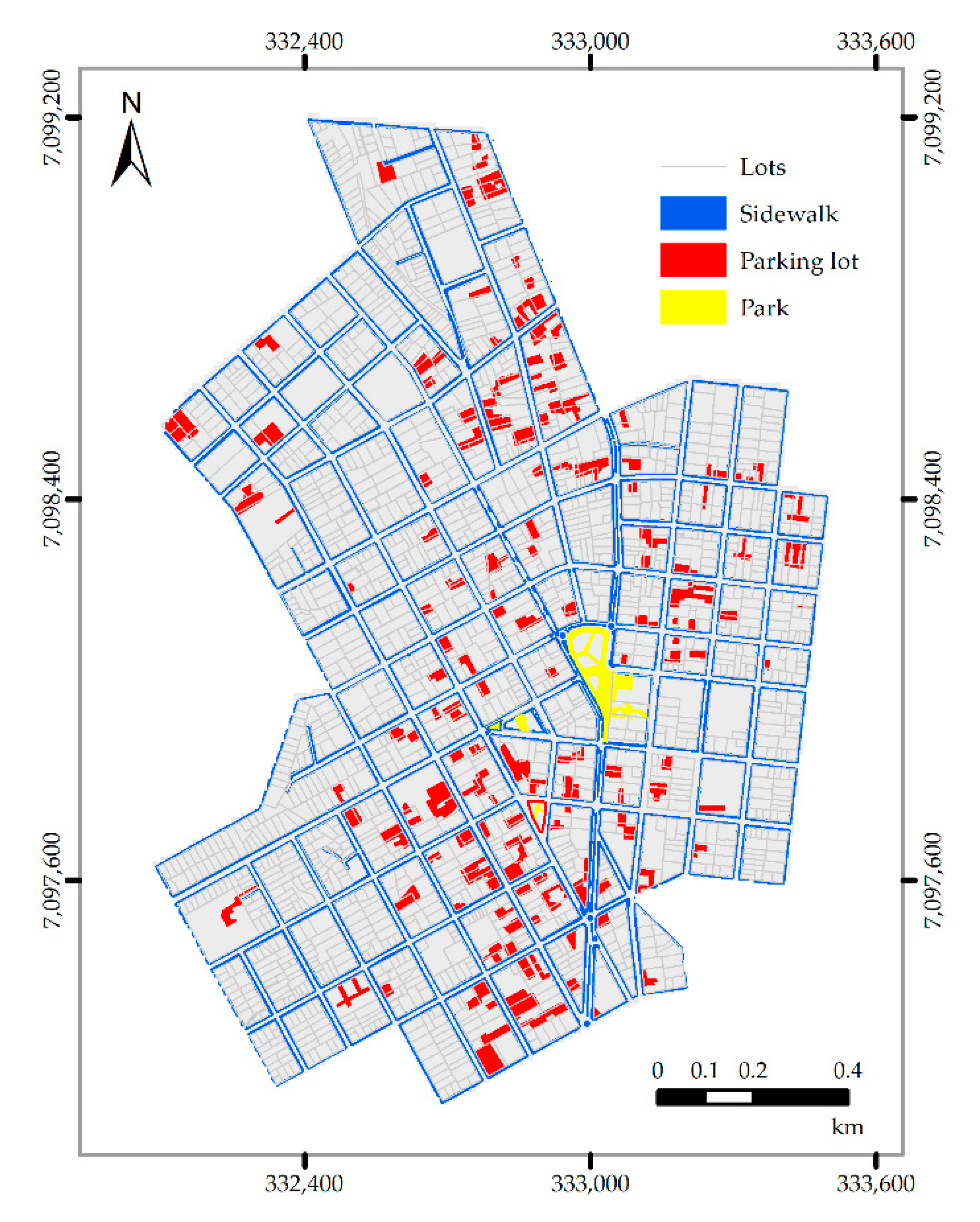

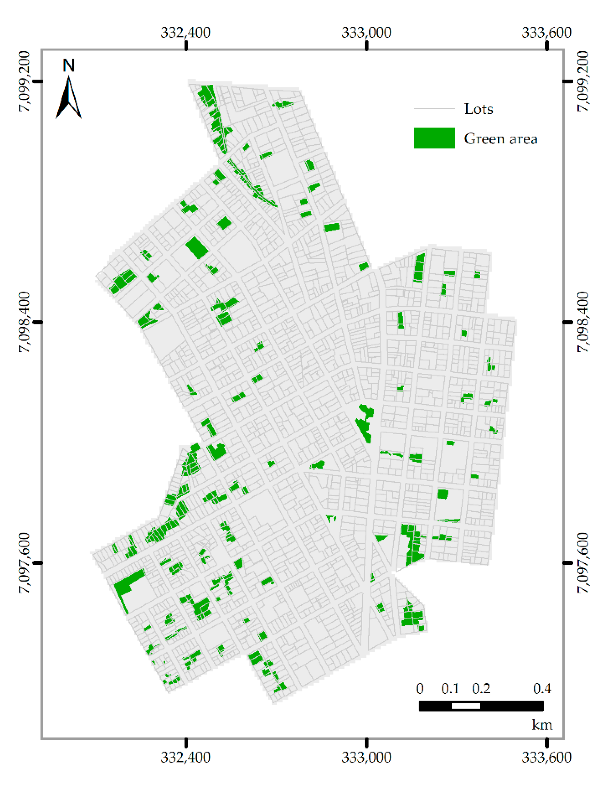
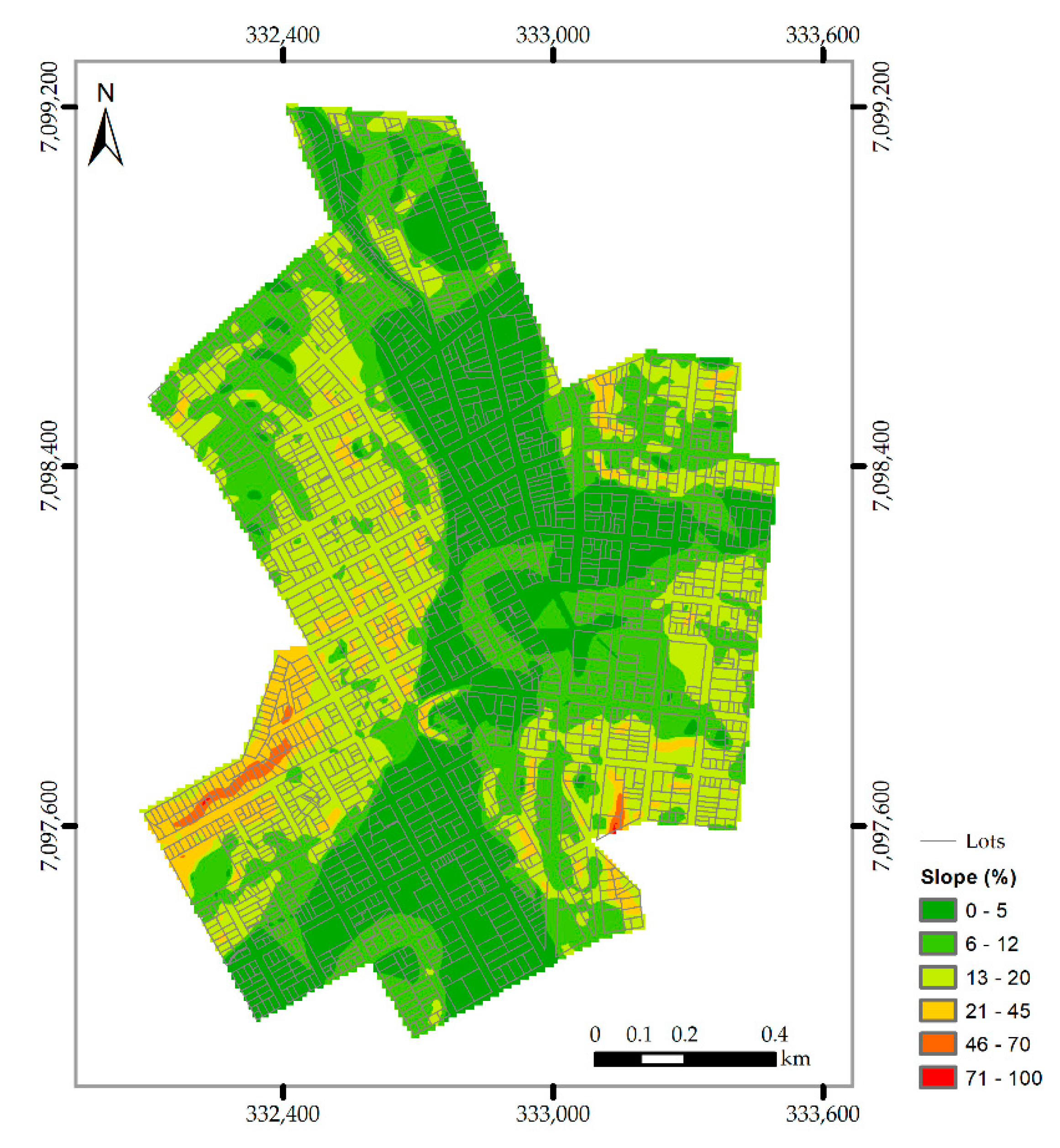
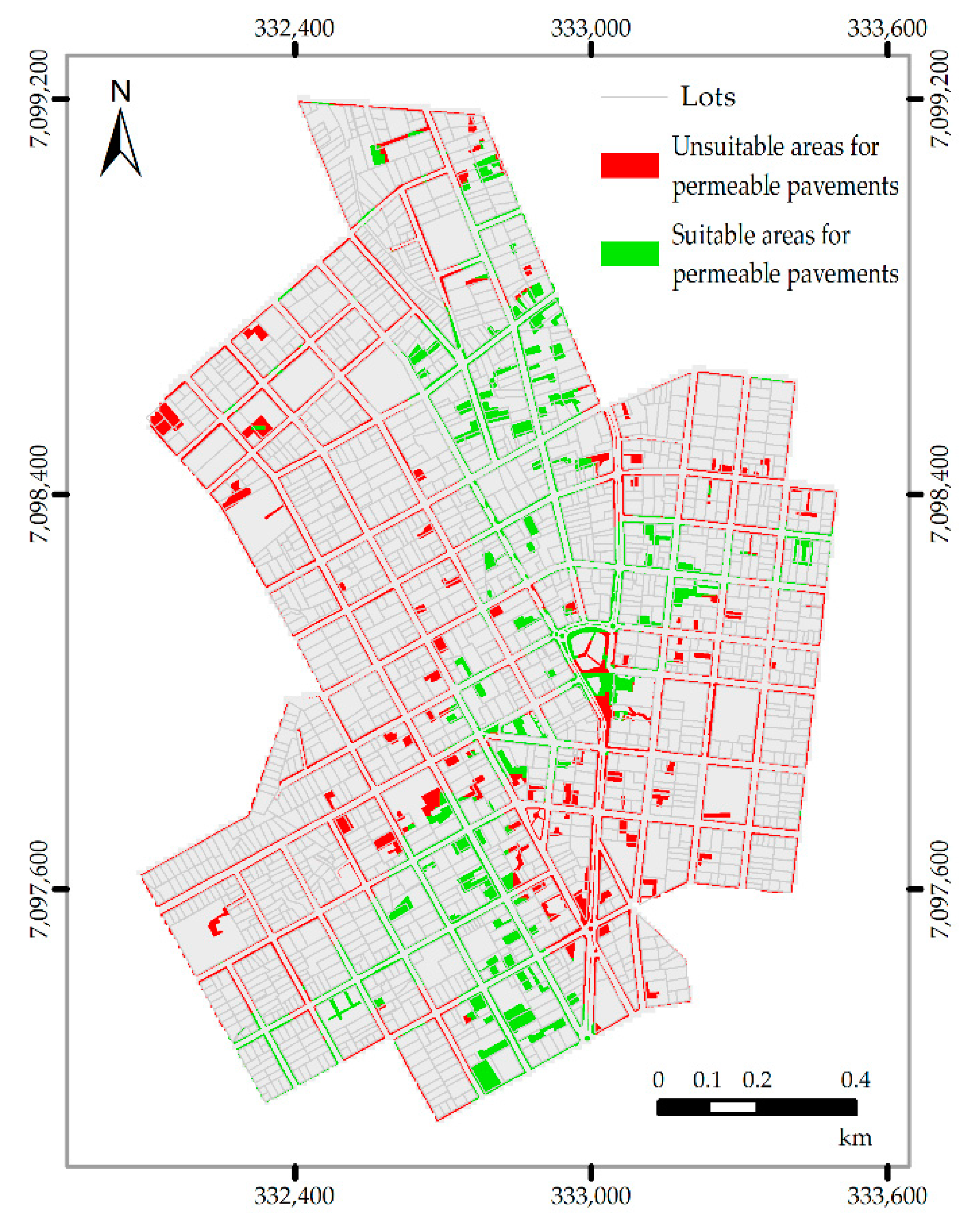
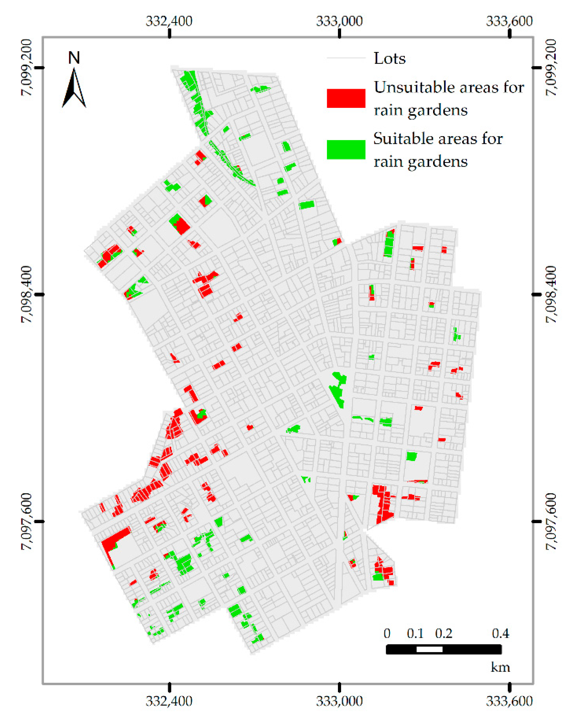
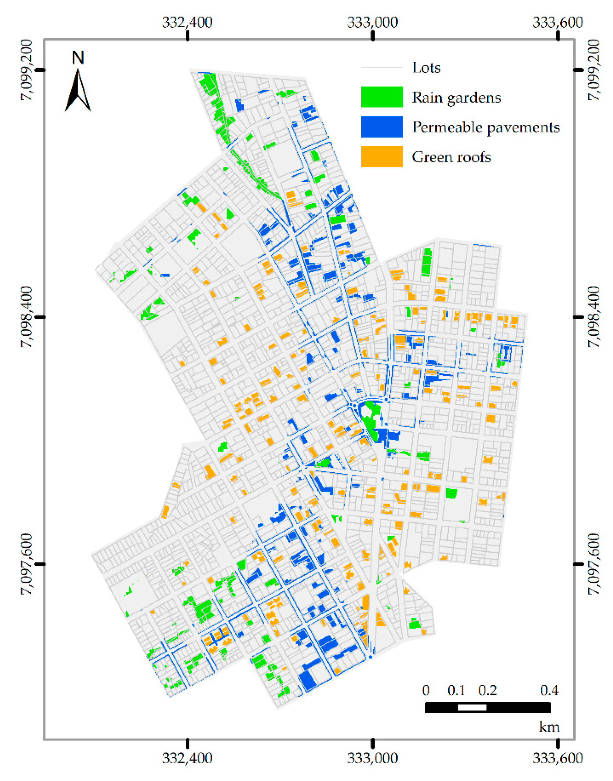
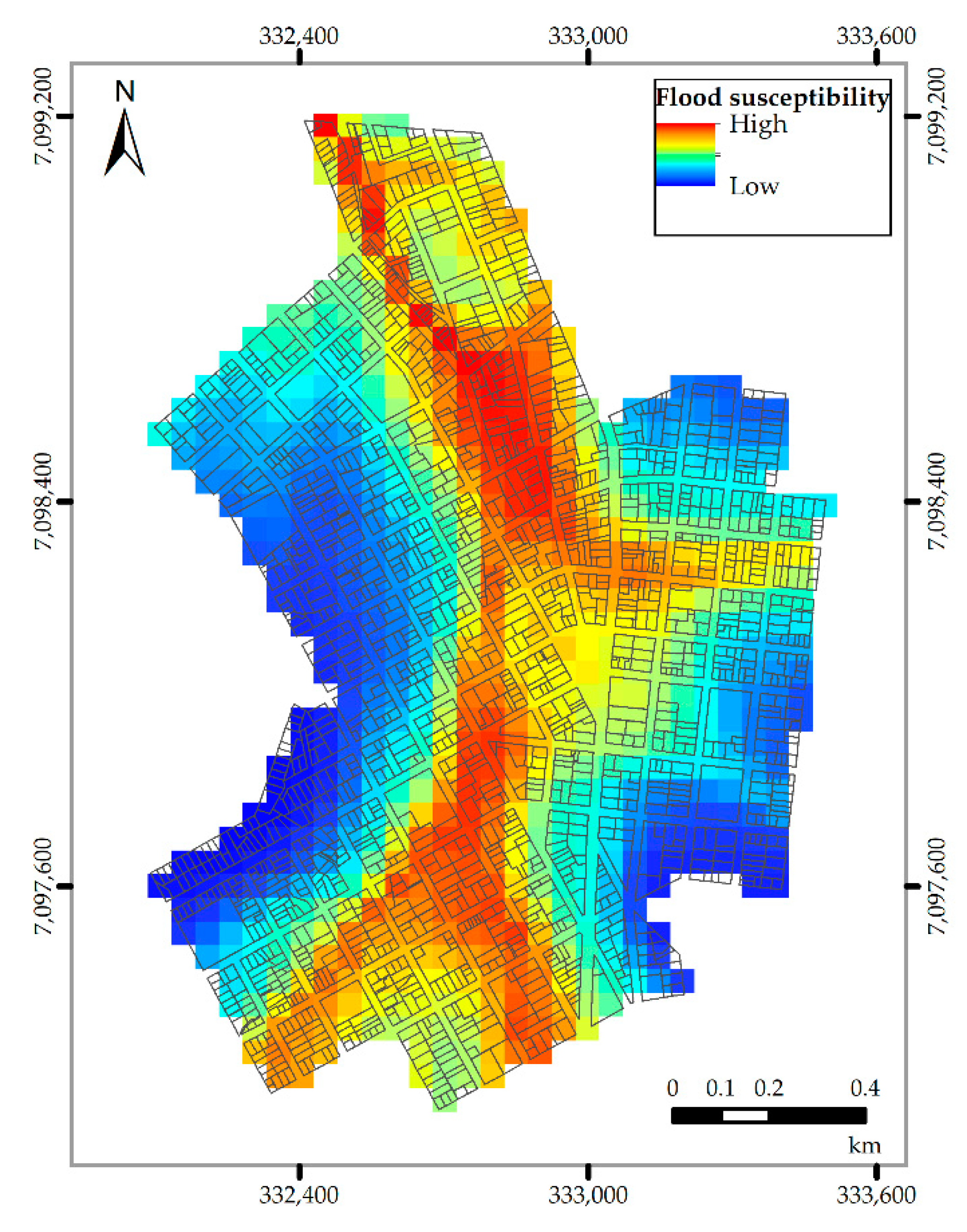
| Permeable Pavement | Rain Garden | Green Roof | Rainwater Harvesting Tanks | |
|---|---|---|---|---|
| Slope | <5% | <12% | <42% (roof) | Not applicable |
| Hydrologic Soil Group | A–B | A–D | Not applicable | Not applicable |
| Required area size (m2) | <12,000 | 10–1000 | Not applicable | Not applicable |
| Land use | Paved area | Vegetation area | Roof slab | Not applicable |
| Initially Selected Area (m2) | Proportionality of Total Area (%) | Suitable Area (m2) | Proportionality of Total Area (%) | |
|---|---|---|---|---|
| Permeable pavement | 289,664.30 | 15.59 | 116,980.68 | 6.30 |
| Green roof | 73,773.00 | 3.97 | 73,773.00 | 3.97 |
| Rain garden | 117,273.02 | 6.31 | 56,243.75 | 3.03 |
| Total | 480,710.32 | 25.87 | 246,997.43 | 13.30 |
| Buildings Smaller than 100 m2 | Buildings Larger than 100 m2 and Smaller than 300 m2 | Buildings Larger than 300 m2 | Total | |
|---|---|---|---|---|
| Number of buildings | 135 | 654 | 747 | 1536 |
| Tank capacity | 3 m3 | 5 m3 | 10 m3 | - |
| Storage capacity | 405 m3 | 3270 m3 | 7470 m3 | 11,145 m3 |
© 2020 by the authors. Licensee MDPI, Basel, Switzerland. This article is an open access article distributed under the terms and conditions of the Creative Commons Attribution (CC BY) license (http://creativecommons.org/licenses/by/4.0/).
Share and Cite
Aguiar, C.R.d.; Nuernberg, J.K.; Leonardi, T.C. Multicriteria GIS-Based Approach in Priority Areas Analysis for Sustainable Urban Drainage Practices: A Case Study of Pato Branco, Brazil. Eng 2020, 1, 96-111. https://doi.org/10.3390/eng1020006
Aguiar CRd, Nuernberg JK, Leonardi TC. Multicriteria GIS-Based Approach in Priority Areas Analysis for Sustainable Urban Drainage Practices: A Case Study of Pato Branco, Brazil. Eng. 2020; 1(2):96-111. https://doi.org/10.3390/eng1020006
Chicago/Turabian StyleAguiar, Claudinei Rodrigues de, Jéssica Klemm Nuernberg, and Thays Cristiane Leonardi. 2020. "Multicriteria GIS-Based Approach in Priority Areas Analysis for Sustainable Urban Drainage Practices: A Case Study of Pato Branco, Brazil" Eng 1, no. 2: 96-111. https://doi.org/10.3390/eng1020006
APA StyleAguiar, C. R. d., Nuernberg, J. K., & Leonardi, T. C. (2020). Multicriteria GIS-Based Approach in Priority Areas Analysis for Sustainable Urban Drainage Practices: A Case Study of Pato Branco, Brazil. Eng, 1(2), 96-111. https://doi.org/10.3390/eng1020006


