Evolution and Analysis of Landslides in Lowland Areas: The Case Study of Reuil in the Champagne Vineyard Region (Marne, France)

 , , , , and
Abstract
1. Introduction
2. Study Area
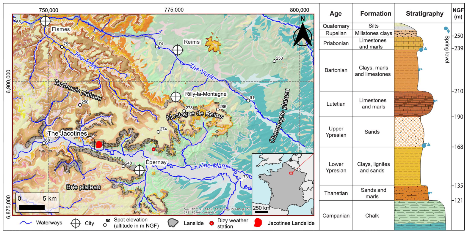
2.1. Regional Context
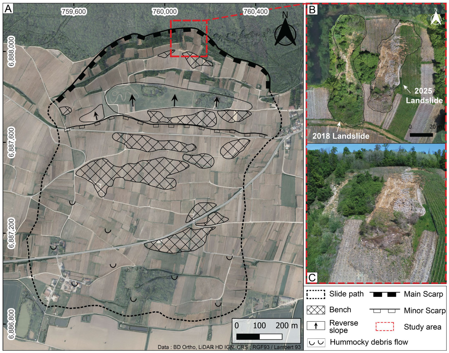
2.2. The Jacotines Landslide

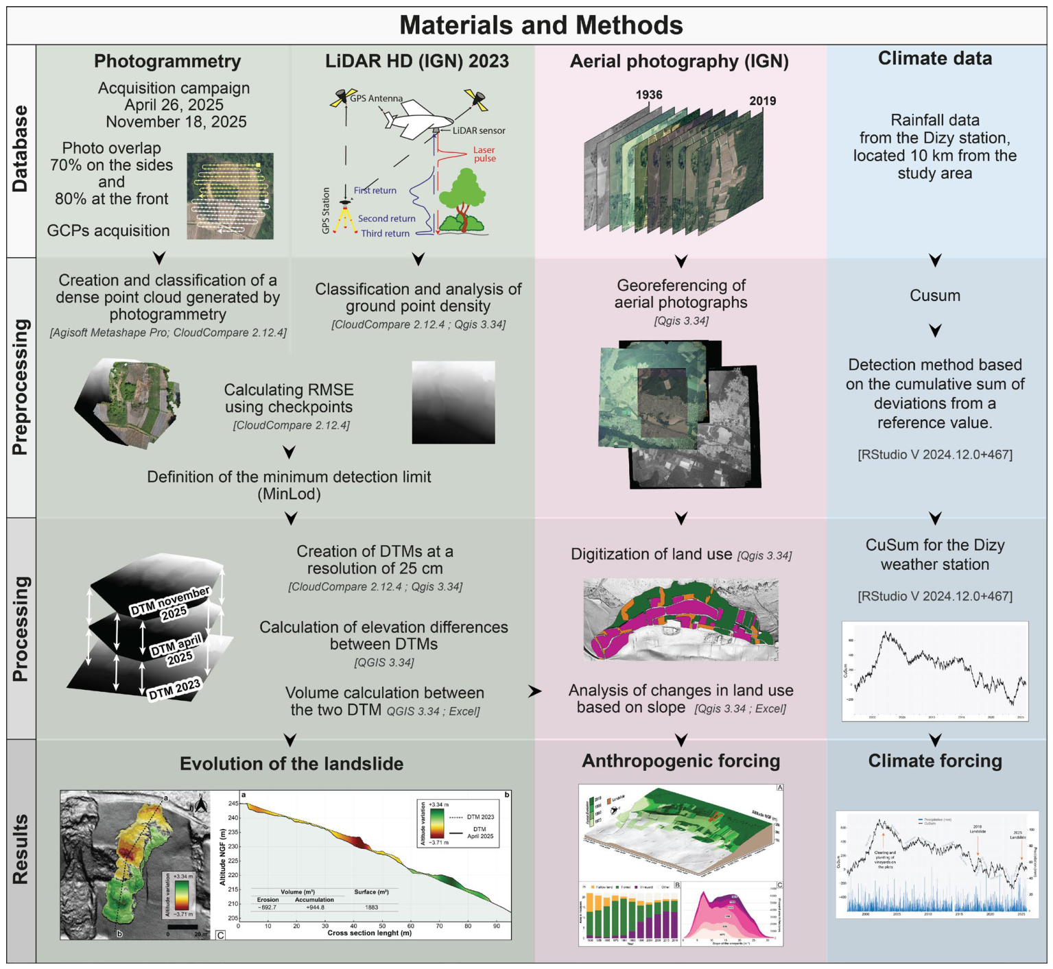
3. Materials and Methods

4. Results
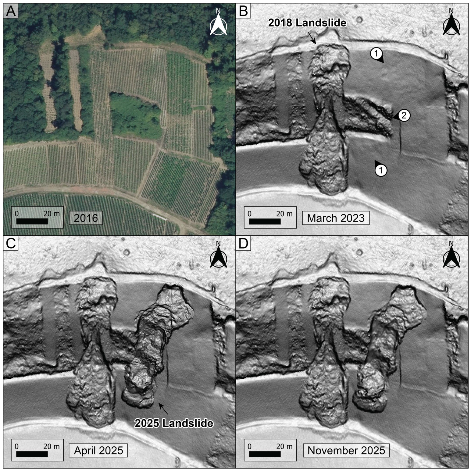
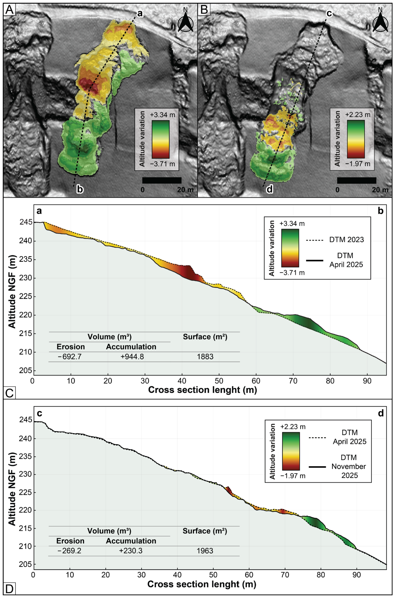
4.1. Evolution of the Landslide Area Using Photogrammetry and LiDAR Analysis


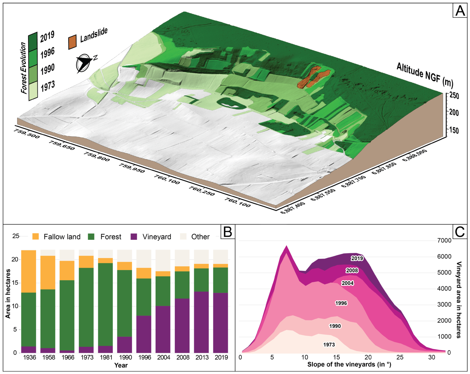
4.2. Land-Use Change

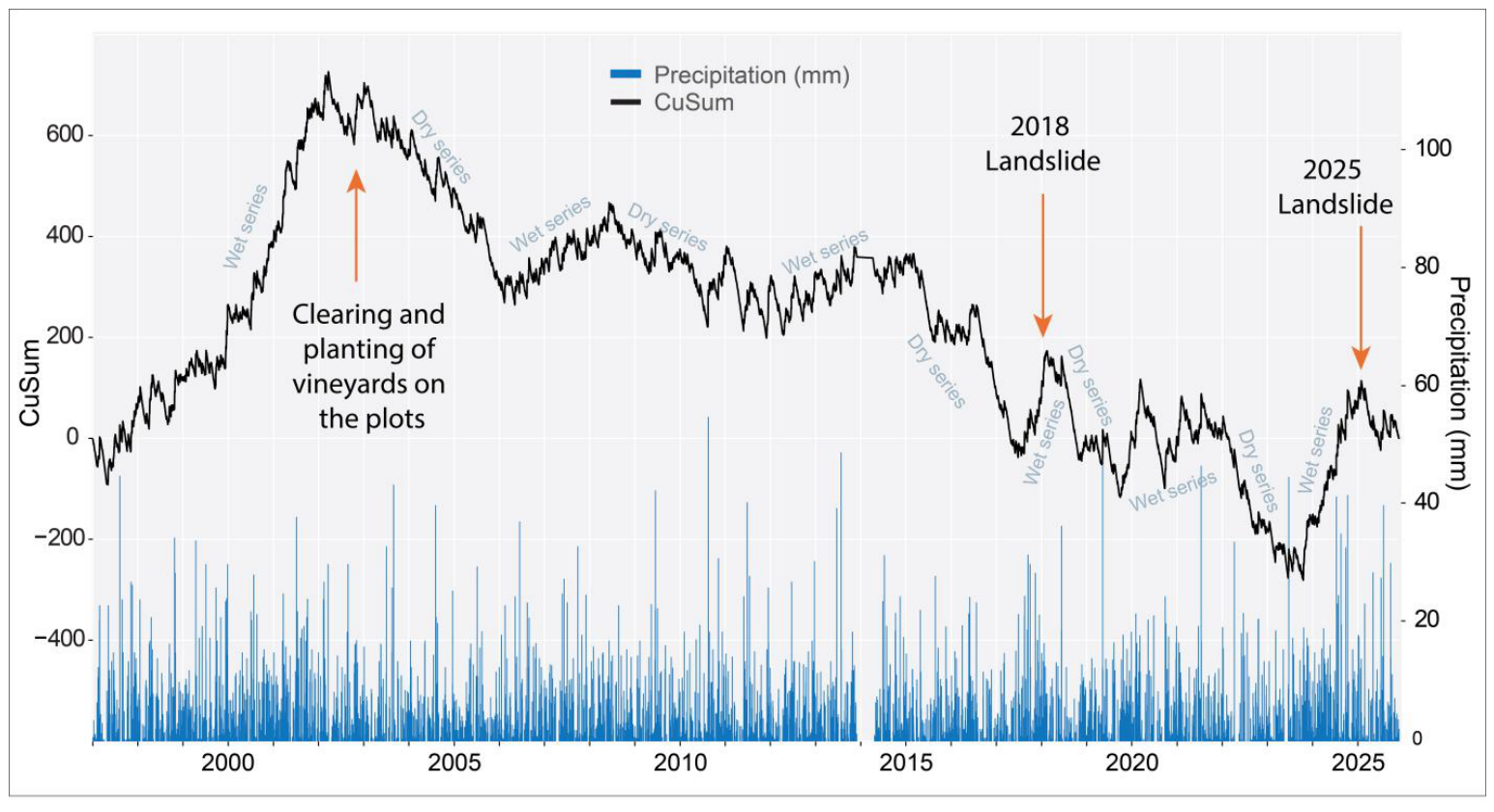
4.3. Analysis of Climatic Conditions
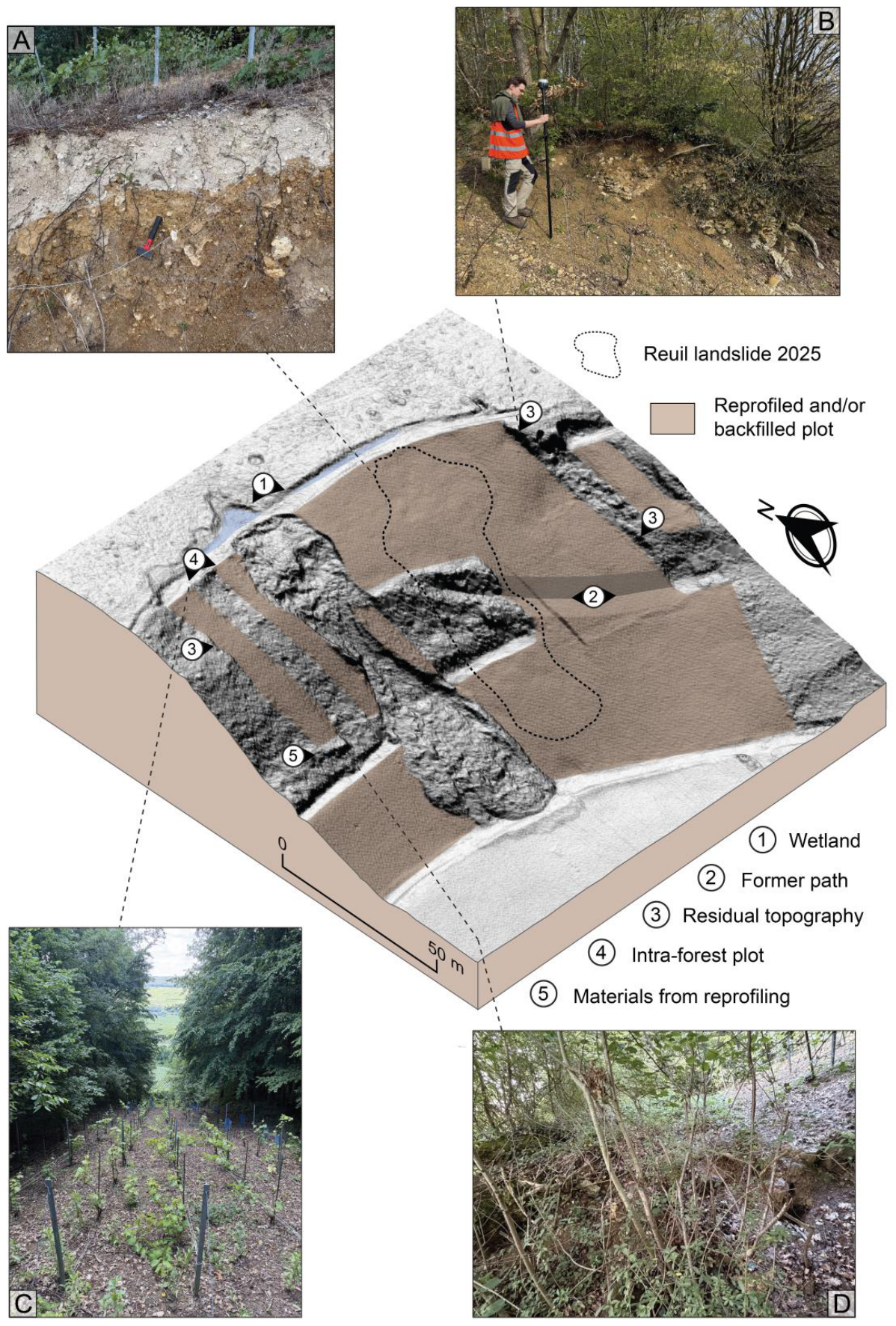
5. Discussion
6. Conclusions
Author Contributions
Funding
Data Availability Statement
Conflicts of Interest
Abbreviations
| DTM | Digital Terrain Model |
| DoD | Differentials of DEM |
| MinLoD | Minimum Limit of Detection |
| RTK | Real Time Kinematic |
| GCP | Ground Control Point |
| RMSE | Root-Mean-Square Error |
| IGN | Institut National de l’information Géographique et forestière |
| AOC | Appellation d’Origine Contrôlée |
References
- Dikau, R.; Brunsden, D.; Schrott, L.; Ibsen, M.-L. Landslides Recognition: Identification, Movements and Causes; John Wiley and Sons: Chichester, UK, 1996; 251p. [Google Scholar] [CrossRef] [Scilit]
- Demoulin, A.; Pissart, A.; Schroeder, C. On the origin of late Quaternary palaeolandslides in the Liège (E Belgium) area. Int. J. Earth Sci. 2003, 92, 795–805. [Google Scholar] [CrossRef] [Scilit]
- Hadji, R.; Limani, Y.; Baghem, M.; el Madjid Chouabi, A.; Demdoum, A. Geologic, topographic and climatic controls in landslide hazard assessment using GIS modeling: A case study of Souk Ahras region, NE Algeria. Quat. Int. 2013, 302, 224–237. [Google Scholar] [CrossRef] [Scilit]
- Fressard, M.; Maquaire, O.; Thiery, Y.; Davidson, R.; Lissak, C. Multi-method characterisation of an active landslide: Case study in the Pays d’Auge plateau (Normandy, France). Geomorphology 2016, 270, 22–39. [Google Scholar] [CrossRef] [Scilit]
- Thirard, G.; Grandjean, G.; Thiery, Y.; Maquaire, O.; François, B.; Lissak, C.; Costa, S. Hydrogeological assessment of a deep-seated coastal landslide based on a multidisciplinary approach. Geomorphology 2020, 371, 107440. [Google Scholar] [CrossRef] [Scilit]
- Fang, Z.; Morales, A.B.; Wang, Y.; Lombardo, L. Climate change has increased rainfall-induced landslide damages in central China. Int. J. Disaster Risk Reduct. 2025, 119, 105320. [Google Scholar] [CrossRef] [Scilit]
- Ramzan, M.; Cui, P.; Ualiyeva, D.; Mukhtar, H.; Bazai, N.A.; Baig, M.A. Impact of climate change on landslides along N-15 Highway, northern Pakistan. Adv. Clim. Change Res. 2025, 16, 397–408. [Google Scholar] [CrossRef] [Scilit]
- Pánek, T.; Hradecky, J.; Smolkova, V.; Silhan, K. Giant ancient landslide in the Alma water gap (Crimean Mountains, Ukraine): Notes to the predisposition structure, and chronology. Landslides 2008, 5, 367–378. [Google Scholar] [CrossRef] [Scilit]
- Pánek, T.; Hradecky, J.; Smolkova, V.; Silhan, K. Gigantic low-gradient landslides in the northern periphery of the Crimean Mountains (Ukraine). Geomorphology 2008, 95, 449–473. [Google Scholar] [CrossRef] [Scilit]
- Preuth, T.; Glade, T.; Demoulin, A. Stability analysis of a human-influenced landslide in eastern Belgium. Geomorphology 2010, 120, 38–47. [Google Scholar] [CrossRef] [Scilit]
- Vranken, L.; Van Turnhout, P.; Van Den Eeckhaut, M.; Vanderkerckhove, L.; Poesen, J. Economic valuation of landslide damage in hilly regions: A case study from Flanders, Belgium. Sci. Total Environ. 2013, 447, 323–336. [Google Scholar] [CrossRef] [Scilit] [PubMed]
- Neuhäuser, B.; Terhorst, B. Landslide susceptibility assessment using “weights-of-evidence” applied to a study area at the Jurassic escarpment (SW-Germany). Geomorphology 2007, 86, 12–24. [Google Scholar] [CrossRef] [Scilit]
- Sass, O.; Bell, R.; Glade, T. Comparison of GPR, 2D-resistivity and traditional techniques for the subsurface exploration of the Oshingen landslide, Swabian Alb (Germany). Geomorphology 2008, 93, 89–103. [Google Scholar] [CrossRef] [Scilit]
- Terhorst, B. Periglacial cover beds ans soils in landslide areas of SW-Germany. Catena 2007, 71, 467–476. [Google Scholar] [CrossRef] [Scilit]
- Van Den Eeckhaut, M.; Marre, A.; Poesen, J. Comparison of two landslide susceptibility assessments in the Champagne-Ardenne region (France). Geomorphology 2010, 11, 141–155. [Google Scholar] [CrossRef] [Scilit]
- Bollot, N.; Pierre, G.; Grandjean, G.; Fronteau, G.; Devos, A.; Lejeune, O. Internal Structure and Reactivations of a Mass Movement: The Case Study of the Jacotines Landslide (Champagne Vineyards, France). GeoHazards 2023, 4, 183–196. [Google Scholar] [CrossRef] [Scilit]
- Ortonovi, S.; Bollot, N.; Pierre, G.; Deroin, J.P. Apport de la télédétection à l’analyse des glissements de terrain du vignoble champenois entre Epernay et Dormans (Marne, France). Géomorphol. Relief Process. Environ. 2021, 2, 147–158. [Google Scholar] [CrossRef] [Scilit]
- Bollot, N.; Benoit, A.; Berthe, J.; Combaz, D.; Krauffel, T.; Devos, A.; Lejeune, O.; Ancelin, P.-Y. Analysis of the Evolution of Lowland Landslides in Temperate Environments According to Climatic Conditions Based on LiDAR Data: A Case Study from Rilly (Champagne Vineyard Region, Northeastern France). Geosciences 2025, 15, 191. [Google Scholar] [CrossRef] [Scilit]
- Ling, C.; Xu, Q.; Zhang, Q.; Ran, J.; Lv, H. Application of electrical resistivity tomography for investigating the internal structure of a translational landslide and characterizing its groundwater circulation (Kualiangzi landslide, Southwest China). J. Appl. Geophys. 2016, 131, 154–162. [Google Scholar] [CrossRef] [Scilit]
- Bollot, N.; Pierre, G.; Devos, A.; Lutz, P.; Ortonovi, S. Hydrogeology of a landslide: A case study in the Montagne de Reims (Paris basin, France). Q. J. Eng. Geol. Hydrogeol. 2022, 56, 2021–2041. [Google Scholar] [CrossRef] [Scilit]
- Williams, R. DEMs of Difference. Geomorphol. Tech. 2012, 2, 1–17. [Google Scholar]
- Lague, D.; Brodu, N.; Leroux, J. Accurate 3D comparison of complex topography with terrestrial laser scanner: Application to the Rangitikei canyon (NZ). ISPRS J. Photogramm. Remote Sens. 2013, 82, 10–26. [Google Scholar] [CrossRef] [Scilit]
- Lu, X.; Li, Y.; Washington-Allen, R.A.; Li, Y. Structural and sedimentological connectivity on a rilled hillslope. Sci. Total Environ. 2019, 655, 1479–1494. [Google Scholar] [CrossRef] [Scilit] [PubMed]
- Bailey, G.; Li, Y.; McKinney, N.; Yoder, D.; Wright, W.; Washington-Allen, R. Las2DoD: Change Detection Based on Digital Elevation Models Derived from Dense Point Clouds with Spatially Varied Uncertainty. Remote Sens. 2022, 14, 1537. [Google Scholar] [CrossRef] [Scilit]
- Dewitte, O.; Jasselette, J.C.; Cornet, Y.; Van Den Eeckhaut, M.; Collignon, A.; Poesen, J.; Demoulin, A. Tracking landslide displacements by multi-temporal DTMs: A combined aerial stereophotogrammetric and LIDAR approach in western Belgium. Eng. Geol. 2008, 99, 11–22. [Google Scholar] [CrossRef] [Scilit]
- Mora, O.E.; Lenzano, M.G.; Toth, C.K.; Grejner-Brzezinska, D.A.; Fayne, J.V. Landslide change detection based on multi-temporal Airborne LiDAR-derived DEMs. Geosciences 2018, 8, 23. [Google Scholar] [CrossRef] [Scilit]
- Hung, C.L.; Tseng, C.W.; Huang, M.J.; Tseng, C.M.; Chang, K.J. Multi-temporal high-resolution landslide monitoring based on uas photogrammetry and uas lidar geoinformation. Int. Arch. Photogramm. Remote Sens. Spat. Inf. Sci. 2019, 42, 157–160. [Google Scholar] [CrossRef] [Scilit]
- Sestras, P.; Badea, G.; Badea, A.C.; Salagean, T.; Oniga, V.E.; Roșca, S.; Bilașco, Ș.; Bruma, S.; Spalević, V.; Billi, P.; et al. A novel method for landslide deformation monitoring by fusing UAV photogrammetry and LiDAR data based on each sensor’s mapping advantage in regards to terrain feature. Eng. Geol. 2025, 346, 107890. [Google Scholar] [CrossRef] [Scilit]
- Berthe, J. Apport du LiDAR Aéroporté à la Compréhension des Hydrosystèmes—Exemple de la Montagne de Reims. Ph.D. Thesis, Université de Reims Champagne-Ardenne, Reims, France, 2024; 412p. Available online: https://theses.hal.science/tel-04491099v1 (accessed on 29 August 2024).
- Hengl, T. Finding the right pixel size. Comput. Geosci. 2006, 32, 1283–1298. [Google Scholar] [CrossRef] [Scilit]
- Jaud, M.; Bertin, S.; Beauverger, M.; Augereau, E.; Delacourt, C. RTK GNSS-assisted terrestrial SfM photogrammetry without GCP: Application to coastal morphodynamics monitoring. Remote Sens. 2020, 12, 1889. [Google Scholar] [CrossRef] [Scilit]
- Ancelin, J.; Ladet, S.; Heintz, W. Le Real Time Kinematic collaboratif, lowcost et open source. Positionnement GNSS temps réel, cinématique, collaboratif et en accès libre et à faible coût. In Spatial Analysis and GEOmatics 2023; Centre de Recherche en Données et Intelligence Géospatiales de l’Université Laval: Quebec, QC, Canada, 2023; pp. 184–197. Available online: https://ut3-toulouseinp.hal.science/hal-04144737/ (accessed on 6 March 2026).
- Dabove, P.; Bagheri, M. Enhancing atmospheric monitoring capabilities: A comparison of low-and high-cost GNSS networks for tropospheric estimations. Remote Sens. 2024, 16, 2223. [Google Scholar] [CrossRef] [Scilit]
- Ancelin, J.; Ladet, S.; Heintz, W. CentipedeRTK, un réseau pour la géolocalisation haute précision au service de l’environnement. J. Interdiscip. Methodol. Issues Sci. 2025, 12, 14252. [Google Scholar] [CrossRef] [Scilit]
- Walstra, J.; Chandler, J.; Dixon, N.; Dijkstra, T. Aerial photography and digital photogrammetry for landslide monitoring. Geol. Soc. Lond. Spec. Publ. 2007, 283, 53–63. [Google Scholar] [CrossRef] [Scilit]
- Stumpf, A.; Malet, J.P.; Allemand, P.; Pierrot-deseilligny, M.; Skupinski, G. Ground-based multi-view photogrammetry for the monitoring of landslide deformation and erosion. Geomorphology 2015, 231, 130–145. [Google Scholar] [CrossRef] [Scilit]
- Fernandez, T.; Perez, J.L.; Colomo, C.; Cardenal, J.; Delgado, J.; Palenzuela, J.A.; Irigaray, C.; Chacon, J. Assessment of the evolution of a landslide using digital photogrammetry and LiDAR techniques in the Alpujarras region (Granada, southeastern Spain). Geosciences 2017, 7, 32. [Google Scholar] [CrossRef] [Scilit]
- Cheng, Z.; Gong, W.; Tang, H.; Juang, C.H.; Deng, Q.; Chen, J.; Ye, X. UAV photogrammetry-based remote sensing and preliminary assessment of the behavior of a landslide in Guizhou, China. Eng. Geol. 2021, 289, 106172. [Google Scholar] [CrossRef] [Scilit]
- Domínguez-Cuesta, M.J.; Rodríguez-Rodríguez, L.; López-Fernández, C.; Pando, L.; Cuervas-Mons, J.; Olona, J.; González-Pumariega, P.; Serrano, J.; Valenzuela, P.; Jiménez-Sánchez, M. Using Remote Sensing Methods to Study Active Geomorphologic Processes on Cantabrian Coastal Cliffs. Remote Sens. 2022, 14, 5139. [Google Scholar] [CrossRef] [Scilit]
- Zhan, X.; Zhang, X.; Wang, X.; Diao, X.; Qi, L. Comparative analysis of surface deformation monitoring in a mining area based on UAV-lidar and UAV photogrammetry. Photogramm. Rec. 2024, 39, 373–391. [Google Scholar] [CrossRef] [Scilit]
- Liang, Z.; Gabrieli, F.; Pol, A.; Brezzi, L. Automated Photogrammetric Tool for Landslide Recognition and Volume Calculation Using Time-Lapse Imagery. Remote Sens. 2024, 16, 3233. [Google Scholar] [CrossRef] [Scilit]
- Cardenal, J.; Mata, E.; Perez-garcia, J.L.; Delgado, J.; Andez, M.; Gonzalez, A.; Diaz-de-teran, J.R. Close range digital photogrammetry techniques applied to landslide monitoring. Int. Arch. Photogramm. Remote Sens. Spat. Inf. Sci. 2008, 37, 235–240. [Google Scholar]
- Carvajal, F.; Agüera, F.; Perez, M. Surveying a landslide in a road embankment using unmanned aerial vehicle photogrammetry. Int. Arch. Photogramm. Remote Sens. Spat. Inf. Sci. 2012, 38, 201–206. [Google Scholar] [CrossRef] [Scilit]
- Terpstra, T.; Dickinson, J.; Hashemian, A.; Fenton, S. Reconstruction of 3D Accident Sites Using USGS LiDAR, Aerial Images, and Photogrammetry; No. 2019-01-0423; SAE Technical Paper; SAE International: Warrendale, PA, USA, 2019. [Google Scholar] [CrossRef] [Scilit]
- Leem, J.; Kim, J.; Choi, J.; Song, J.J. Comparison of an underground rock face 3D modeling performance: SfM-MVS with optimum photographing settings and LiDAR technology. In Proceedings of the 15th ISRM Congress, Salzburg, Austria, 9–14 October 2023; ISRM: Lisbon, Portugal, 2023. [Google Scholar]
- Brasington, J.; Rumsby, B.T.; McVey, R.A. Monitoring and modelling morphological change in a braided gravel-bed river using high resolution GPS-based survey. Earth Surf. Process. Landf. J. Br. Geomorphol. Res. Group 2000, 25, 973–990. [Google Scholar] [CrossRef]
- Brasington, J.; Langham, J.; Rumsby, B. Methodological sensitivity of morphometric estimates of coarse fluvial sediment transport. Geomorphology 2003, 53, 299–316. [Google Scholar] [CrossRef] [Scilit]
- Wheaton, J.M.; Brasington, J.; Darby, S.E.; Sear, D.A. Accounting for uncertainty in DEMs from repeat topographic surveys: Improved sediment budgets. Earth Surf. Process. Landf. J. Br. Geomorphol. Res. Group 2010, 35, 136–156. [Google Scholar] [CrossRef] [Scilit]
- Vericat, D.; Smith, M.W.; Brasington, J. Patterns of topographic change in sub-humid badlands determined by high resolution multi-temporal topographic surveys. Catena 2014, 120, 164–176. [Google Scholar] [CrossRef] [Scilit]
- James, M.R.; Robson, S.; Smith, M.W. 3D uncertainty-based topographic change detection with structure-from-motion photogrammetry: Precision maps for ground control and directly georeferenced surveys. Earth Surf. Process. Landf. 2017, 42, 1769–1788. [Google Scholar] [CrossRef] [Scilit]
- Wang, R.; Sun, H.; Yang, J.; Zhang, S.; Fu, H.; Wang, N.; Liu, Q. Quantitative Evaluation of Gully Erosion Using Multitemporal UAV Data in the Southern Black Soil Region of Northeast China: A Case Study. Remote Sens. 2022, 14, 1479. [Google Scholar] [CrossRef] [Scilit]
- Page, E.S. Continuous inspection schemes. Biometrika 1954, 41, 100–115. [Google Scholar] [CrossRef] [Scilit]
- Martha, T.R.; Kerle, N.; Jetten, V.; Van Westen, C.J.; Kumar, K.V. Landslide volumetric analysis using Cartosat-1-derived DEMs. IEEE Geosci. Remote Sens. Lett. 2010, 7, 582–586. [Google Scholar] [CrossRef] [Scilit]
- Turner, D.; Lucieer, A.; De Jong, S.M. Time Series Analysis of Landslide Dynamics Using an Unmanned Aerial Vehicle (UAV). Remote Sens. 2015, 7, 1736–1757. [Google Scholar] [CrossRef] [Scilit]
- Ma, S.Y.; Xu, C.; Xu, X.W. Volume expansion rates of seismic landslides and influencing factors: A case study of the 2008 Wenchuan earthquake. J. Mt. Sci. 2019, 16, 1731–1742. [Google Scholar] [CrossRef] [Scilit]
- Yang, D.; Qiu, H.; Hu, S.; Pei, Y.; Wang, X.; Du, C.; Long, Y.; Cao, M. Influence of successive landslides on topographic changes revealed by multitemporal high-resolution UAS-based DEM. Catena 2021, 202, 105229. [Google Scholar] [CrossRef] [Scilit]
- Marre, A. Existe-t-il des terroirs viticoles en Champagne? Rev. Géograph. l’Est 2004, 44, 17–30. [Google Scholar] [CrossRef] [Scilit]
- Bollot, N.; Devos, A.; Pierre, G. Ressources en eau et glissements de terrain: Exemple du bassin versant de la Semoigne (bassin de Paris, France). Géomorphol. Relief Process. Environ. 2015, 2, 121–132. [Google Scholar] [CrossRef] [Scilit]
- Combaud, A.; Cornuet, J.; Pargny, D.; Marre, A. Évolution des paysages viticoles champenois: Corrélations entre les paramètres historiques, humains et naturels dans le secteur de la Montagne de Reims. Actes Congrès Natx. Soc. Hist. Sci. 2011, 135, 67–80. [Google Scholar]



| LiDAR HD (IGN) | Photogrammetry | Photogrammetry | |
|---|---|---|---|
| Acquisition date | 17 March 2023 | 26 April 2025 | 18 November 2025 |
| Sensor | RIEGL VQ 1560 II | DJI Mavic 3M RTK | DJI Mavic 3M RTK |
| Ground point density | |||
| Points per m2 | Covered area (%) | ||
| NoData | 0.13 | 0.24 | 3.10 |
| 1–5 | 0.74 | 0.01 | 0.14 |
| 5–10 | 1.7 | 0.02 | 0.16 |
| 10–15 | 15.7 | 0.01 | 0.10 |
| >15 | 81.8 | 99.7 | 96.5 |
| Data accuracy | |||
| Checkpoints | 51 | 16 | 17 |
| RMSE | 4.30 cm | 5.67 cm | 5.22 cm |
| Standard deviation | 4.32 cm | 5.61 cm | 5.20 cm |
| Minimum limit of detection (minLoD) | |||
| DTM March 2023–April 2025 | DTM April 2025–November 2025 | ||
| 13.9 cm | 15 cm | ||
Disclaimer/Publisher’s Note: The statements, opinions and data contained in all publications are solely those of the individual author(s) and contributor(s) and not of MDPI and/or the editor(s). MDPI and/or the editor(s) disclaim responsibility for any injury to people or property resulting from any ideas, methods, instructions or products referred to in the content. |
© 2026 by the authors. Licensee MDPI, Basel, Switzerland. This article is an open access article distributed under the terms and conditions of the Creative Commons Attribution (CC BY) license.
Share and Cite
Benoit, A.; Bollot, N.; Krauffel, T.; Berthe, J.; Combaz, D.; Devos, A.; Lejeune, O. Evolution and Analysis of Landslides in Lowland Areas: The Case Study of Reuil in the Champagne Vineyard Region (Marne, France). GeoHazards 2026, 7, 92. https://doi.org/10.3390/geohazards7030092
Benoit A, Bollot N, Krauffel T, Berthe J, Combaz D, Devos A, Lejeune O. Evolution and Analysis of Landslides in Lowland Areas: The Case Study of Reuil in the Champagne Vineyard Region (Marne, France). GeoHazards. 2026; 7(3):92. https://doi.org/10.3390/geohazards7030092
Chicago/Turabian StyleBenoit, Auguste, Nicolas Bollot, Théo Krauffel, Julien Berthe, Delphine Combaz, Alain Devos, and Olivier Lejeune. 2026. "Evolution and Analysis of Landslides in Lowland Areas: The Case Study of Reuil in the Champagne Vineyard Region (Marne, France)" GeoHazards 7, no. 3: 92. https://doi.org/10.3390/geohazards7030092
APA StyleBenoit, A., Bollot, N., Krauffel, T., Berthe, J., Combaz, D., Devos, A., & Lejeune, O. (2026). Evolution and Analysis of Landslides in Lowland Areas: The Case Study of Reuil in the Champagne Vineyard Region (Marne, France). GeoHazards, 7(3), 92. https://doi.org/10.3390/geohazards7030092