Skip to Content
GeoHazardsGeoHazards
  • Article
  • Open Access

3 August 2026

Evolution and Analysis of Landslides in Lowland Areas: The Case Study of Reuil in the Champagne Vineyard Region (Marne, France)


,
,
,
,
,
and
Laboratory UR 3795 Groupe d’Étude sur les Géomatériaux et Environnements Anthropisés (GEGENA), University of Reims Champagne-Ardenne, 57 rue Pierre Taittinger, 51100 Reims, France
*
Author to whom correspondence should be addressed.

Abstract

The slopes of the Champagne vineyards are regularly affected by landslides. Given the high societal and economic stakes, these processes cause significant damage and pose a major challenge for the wine industry, forestry and heritage preservation. Numerous studies have already been conducted to understand their behavior and hydrodynamic functioning. They show varied morphologies and a dominant influence of water resources. However, this forcing does not explain the spatial distribution of current landslides, which occur in upper-slope positions, on the steepest terrain recently planted with vines. Using the two shallow landslides at Reuil, located in the heart of the Marne Valley in the Champagne vineyards, as a study site, recent landslide activity is analyzed through a comparative analysis of three DTMs derived from LiDAR HD data and two UAV photogrammetric surveys. This study reveals the affected areas and displaced volumes, which can reach up to 900 m3. Landslide activity was then correlated with regional climatic data. This research shows that landslides are more likely to occur during a period of excessive rainfall following a drier period. Diachronic analysis of aerial images also demonstrates the influence of land use on landslide activity. In particular, land clearing and vineyard operations on the steepest plots constitute a significant anthropogenic forcing affecting slope stability. Taken together, these results provide greater insight into the changing geomorphological dynamics of the Champagne vineyards. On the one hand, they clarify how landslides occur at vineyard plot scale. On the other hand, they provide initial insights into the resilience of stakeholders (winegrowers, etc.) affected by these instabilities.

1. Introduction

Lowland regions, characterized by low absolute elevations (around 200 m, as in the Montagne de Reims) and reliefs of less than 200 m, are frequently affected by landslides [1]. Since the 2000s, the relationship between instabilities and climatic conditions has been clearly established [2,3,4,5,6,7]. Other triggering factors are frequently highlighted [8,9], particularly human activities [10,11], including in other types of geomorphological contexts. Under these conditions, ground movements are triggered solely by human activity or are caused and exacerbated by a combination of natural and anthropogenic control factors, as is the case in the Bonn region of Germany [12,13,14].
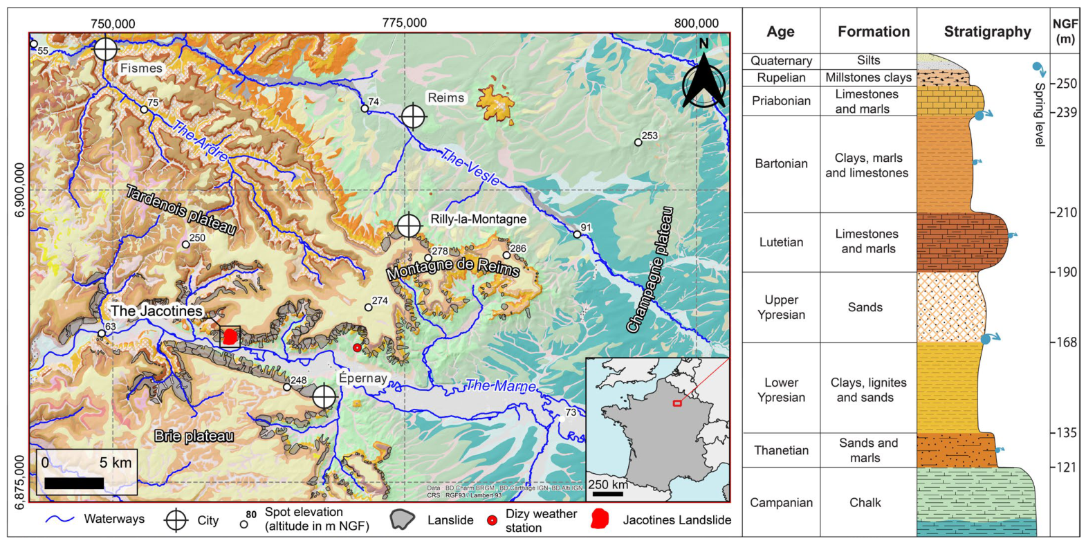
In the Champagne vineyards, east of the Paris Basin, a survey of ground movements has identified more than 350 events, primarily landslides (Figure 1). Their spatial extent and depth (sometimes exceeding 40 m) suggest that these large landslides are ancient and occurred under different morphogenetic conditions than those present today. Thus, they are often attributed to the late glacial period, when the thawing of permafrost exacerbated imbalances on predominantly clayey slopes, or to periods of greater water surplus during the Holocene [15,16]. Under today’s temperate climate, such large-scale landslides are unlikely to occur as frequently because of reduced water availability. Consequently, no events of this magnitude are recorded in historical archives. Nevertheless, partial reactivations and smaller-scale movements occur regularly. They are generally shallow but sufficient to cause considerable damage to vineyards, where vineyard land values are particularly high.
Figure 1. Geologic map, location of study area and stratigraphic log.
The observation and characterization of landslides using imagery is common [17,18], and the use of LiDAR is also becoming increasingly common. These methods allow the precise identification of geomorphic features associated with slope instabilities [4,19]. In the Champagne vineyards, on the northern slope of the Montagne de Reims, the evolution of the Rilly landslide and its reactivations under current climatic conditions had already been demonstrated, revealing that the landslide remains active despite a seemingly unfavorable context [18].
The objective of this study is to assess the impact of controlling factors on landslide evolution and reactivation, through an analysis of landslide activity in relation to climatic conditions and land-use changes.

2. Study Area

2.1. Regional Context

The slopes of the Champagne vineyards are part of the Paleogenic strata in the eastern Paris Basin. The Thanetian sands and marls unconformably overlie the Campanian chalk and are overlain by the clayey layers of the Lower Eocene, the sandy layers of the Upper Eocene, and the clay-marl layers of the Lutetian, Bartonian, and later periods. These formations are incised by the Marne Valley, whose cataclinal breakthrough near Épernay forms a wide funnel. These slopes, like those of the Montagne de Reims—which corresponds to the eastern end of the Ile-de-France cuesta—are regularly affected by landslides displaying a wide range of morphologies, activity levels, and ages (Figure 1). Recent studies highlight the importance of water availability in triggering and sustaining landslide activity [16,20]. In a context of significant societal and economic stakes, these processes cause substantial damage and pose a major challenge for the wine industry. In Reuil, in the Marne Valley, the vineyards are established on large ancient landslides, such as the Jacotines landslide where our study area is located (Figure 1).

2.2. The Jacotines Landslide

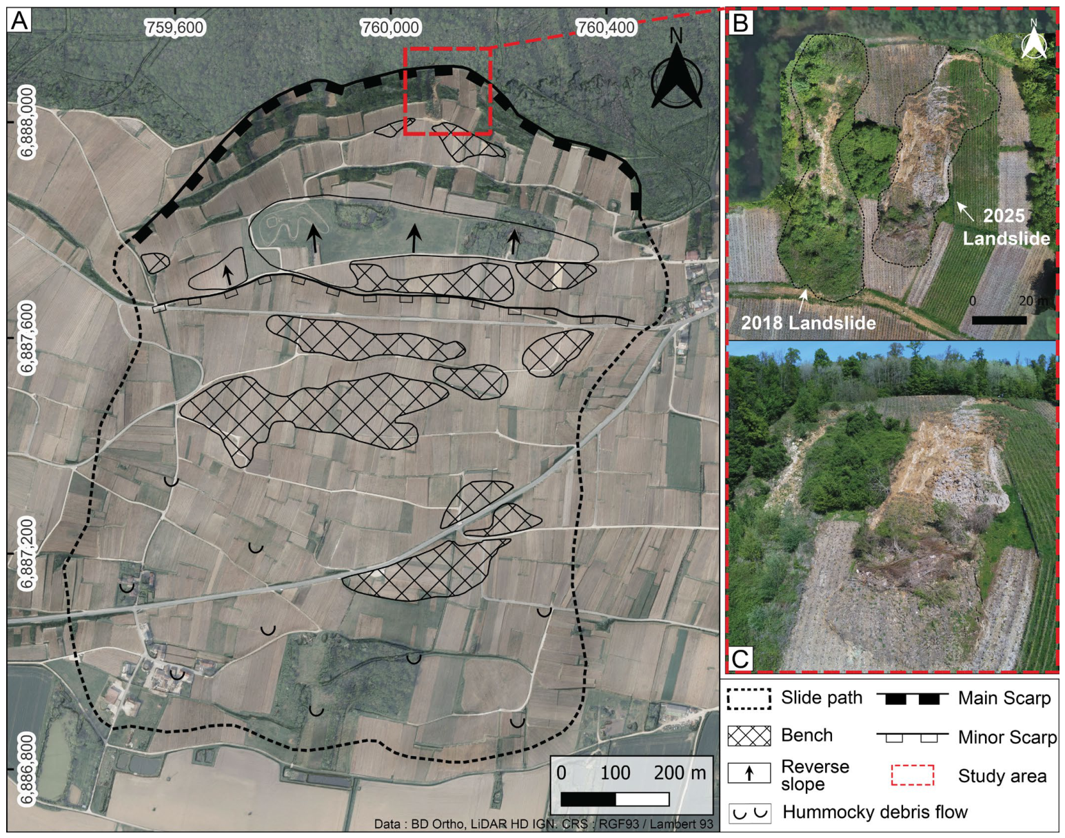
The Jacotines landslide exhibits a morphology typical of the region [16]. It extends across the entire slope, from the edge of the plateau to the valley floor. The edge of the plateau, located at an altitude of approximately 245 m, is characterized by a large amphitheater-shaped scarp with a vertical drop of up to 75 m. Locally, slopes exceeding 20° are found on the scarp. At the foot of the scarp lies a broad counter-slope extending 700 m east to west and approximately 150 m north to south, consistent with the characteristics of major rotational landslides in the region. It is one of the few areas of the slope not planted with vines, mainly due to high soil moisture conditions. Further down the slope, the landslide body exhibits an irregular topography consisting of a multitude of terraces and hummocks of varying sizes. At the bottom of the slope, the toe of the landslide is easily delineated by a significant break in the slope (Figure 2A) [20].
At its summit, near the main scarp, two landslides occurred in January 2018 and February 2025 (Figure 2B,C). These reactivations are typical of the region: they partially affect large, ancient landslides, occur in the upper part of the slope (often along old scarps), and remain shallow (1 to 5 m deep, according to estimates). These two recent landslides thus provide an ideal case study to understand their triggering mechanisms and behavior, and thereby determine the impact of anthropogenic and climatic factors on landslide triggering and recent activity.
Figure 2. (A) The main Jacotines landslide; (B) the two landslides of 2018 and 2025 (mix: BD ORHTO IGN 2022 and Orthomosaic April 2025); (C) Drone photo of the landslides in Reuil, April 2025.

3. Materials and Methods

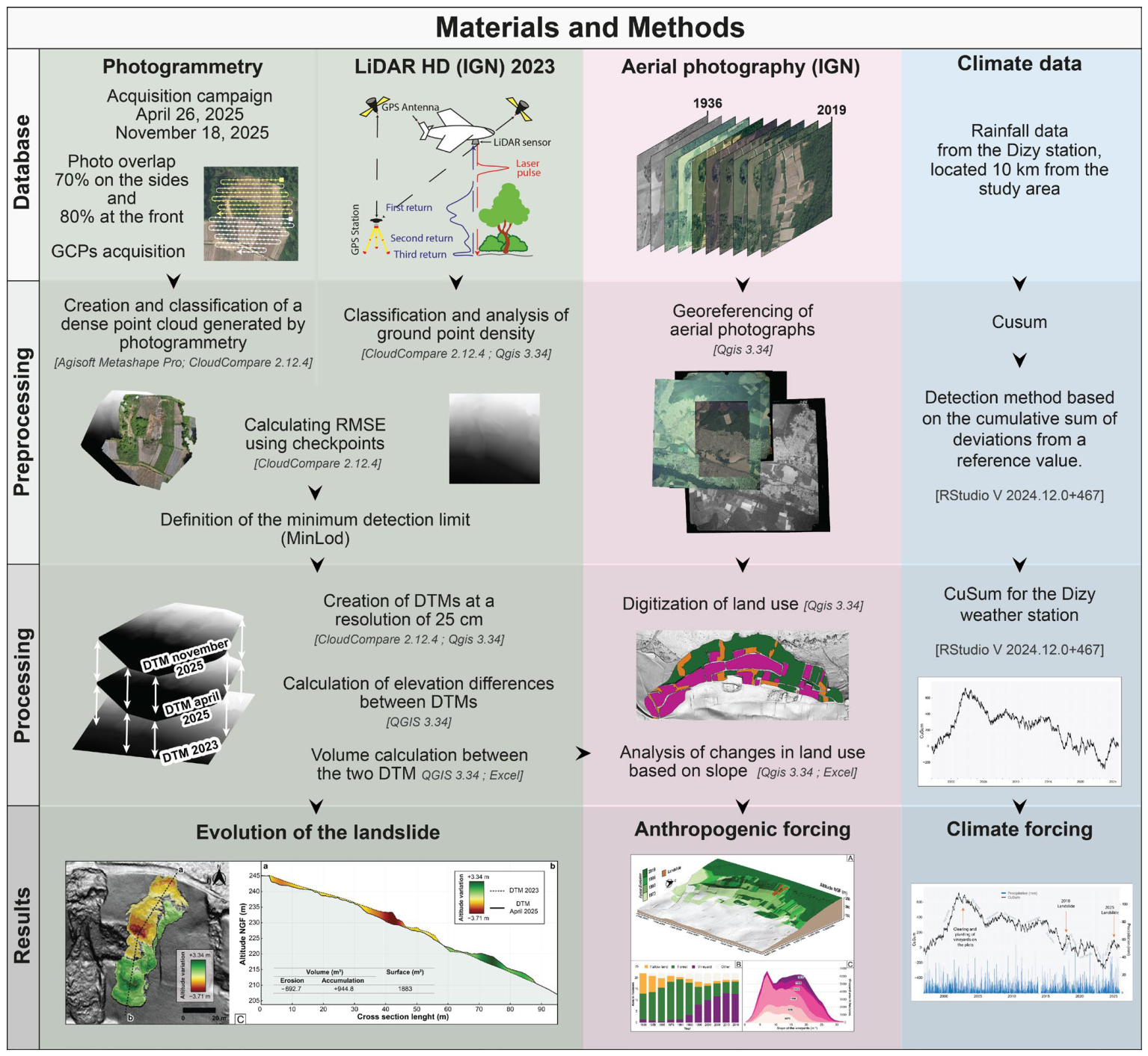
Recent changes in the Reuil landslide at the Jacotines main scarp have been quantified using DTMs (Digital Terrain Models; QGIS 3.34) due to their simple concept, ease of implementation, and direct visualization [21,22,23,24]. The most common approach involves creating a DTM of Difference (DoD) by subtracting the older DTM from the newer one, which yields the elevation differences between the two DTMs for each pixel [18,25,26,27,28]. The DoD represents material movements within our study area, enabling the detection and quantification of affected areas and the calculation of landslide volumes (Figure 3).
The oldest DTM is derived from the 2023 HD LiDAR (IGN). Its acquisition in winter and the land cover characteristics in the study area (deciduous forest and vineyards) ensure a high density of ground points and minimize NoData areas [29]. The high ground-point density—generally exceeding 15 points per square meter—combined with a homogeneous distribution and a NoData proportion of less than 2%, allows for the creation of a digital terrain model with a 25 cm resolution (Table 1) [30].
Table 1. Characteristics of the datasets used in the study area.
Figure 3. Materials and methods used to quantify landslide evolution, land-use changes, and climate data.
Two additional DTMs were generated from photogrammetry data collected during two drone photography campaigns on 26 April 2025 and 18 November 2025 (Table 1). The drone used is a DJI Mavic 3M RTK equipped with a 4/3-inch, 20-megapixel CMOS sensor and a multispectral camera (G/R/RE/NIR) (all of which are manufactered by Da Jiang Innovation, in Shenzhen, China). The onboard RTK module is connected to the Centipede network, which ensures centimeter-level accuracy of the acquired images [31,32,33,34]. Photogrammetry is widely used to monitor the evolution of instabilities [35,36,37,38,39,40,41]. All images were nadir and acquired at an altitude of 30 m with 70% lateral and 80% frontal overlap. A set of topographic points is surveyed in the field using an EMLID Reach RS3 GNSS RTK (manufactered by EMLID, in Budapest, Hungary) receiver connected to the Centipede network. Some of these points are used as GCPs (Ground Control Points) for the photogrammetry performed in Agisoft Metashape Professional 2.3.1. It enables the generation of a dense point cloud which, once classified (Agisoft Metashape Pro 2.3.1, CloudCompare 2.12.4), is used to produce a digital terrain model with centimeter-level accuracy [37,42,43]. The remaining topographic points are used as checkpoints to validate data quality and thus calculate the point cloud error (Table 1). To ensure that the DTMs derived from photogrammetry can be compared with the HD LiDAR (IGN) DTM, they are produced at an identical resolution of 25 cm.
The RMSE values for the point clouds are 4.30 cm for the HD LiDAR (IGN) data and, respectively, 5.67 cm and 5.22 cm for the April and November 2025 photogrammetric datasets. These values are consistent with various studies conducted on the subject (Table 1) [40,44,45].
When comparing the two DTMs, elevation variations may be influenced by errors in each DTM. To observe actual surface changes and accurately quantify volumetric changes, it is necessary to apply a minimum limit of detection (minLoD) that varies depending on the quality of each DTM used. This method retains only elevation changes exceeding this uncertainty threshold, while values within the threshold are discarded. The minLoD approach is widely used [46,47,48,49,50,51] and is calculated as follows:
m i n L o D   =   1.96   ×     σ DTM 1 2 + σ DTM 2 2  
where minLoD represents the threshold for detecting significant elevation changes; 1.96 is the confidence interval, set at a 95% confidence level; σDTM1 and σDTM2 are the standard deviations of the errors for the two compared DTMs.
For the first comparison between the LiDAR HD (IGN) DTM and the April photogrammetric DTM, the standard deviations of the errors are ±4.32 cm and ±5.61 cm, respectively. In this first scenario, (minLoD) is ±13.9 cm; all values within this threshold are considered insignificant in this case. For the second comparison between the two DTMs derived from the April and November photogrammetry campaigns, the standard deviations of the errors are ±5.61 cm and ±5.32 cm, respectively. Any elevation variations within ±15 cm are considered insignificant in this case (Table 1). The minLoD is also taken into account in the calculation of volumes (QGIS 3.34).
Land-use history was analyzed through a diachronic analysis of IGN aerial photographs available through the IGN “Remonter le temps” platform. The digitization of forested areas, fallow, and vineyard makes it possible to track land-use changes and human disturbance for all dates for which images are available: 1936, 1958, 1966, 1973, 1981, 1990, 1996, 2004, 2008, 2013, and 2019 (QGIS 3.34). This analysis provides insight into the potential impacts of human activities in a region where land clearing is common to expand vineyard plots (Figure 4) [17].
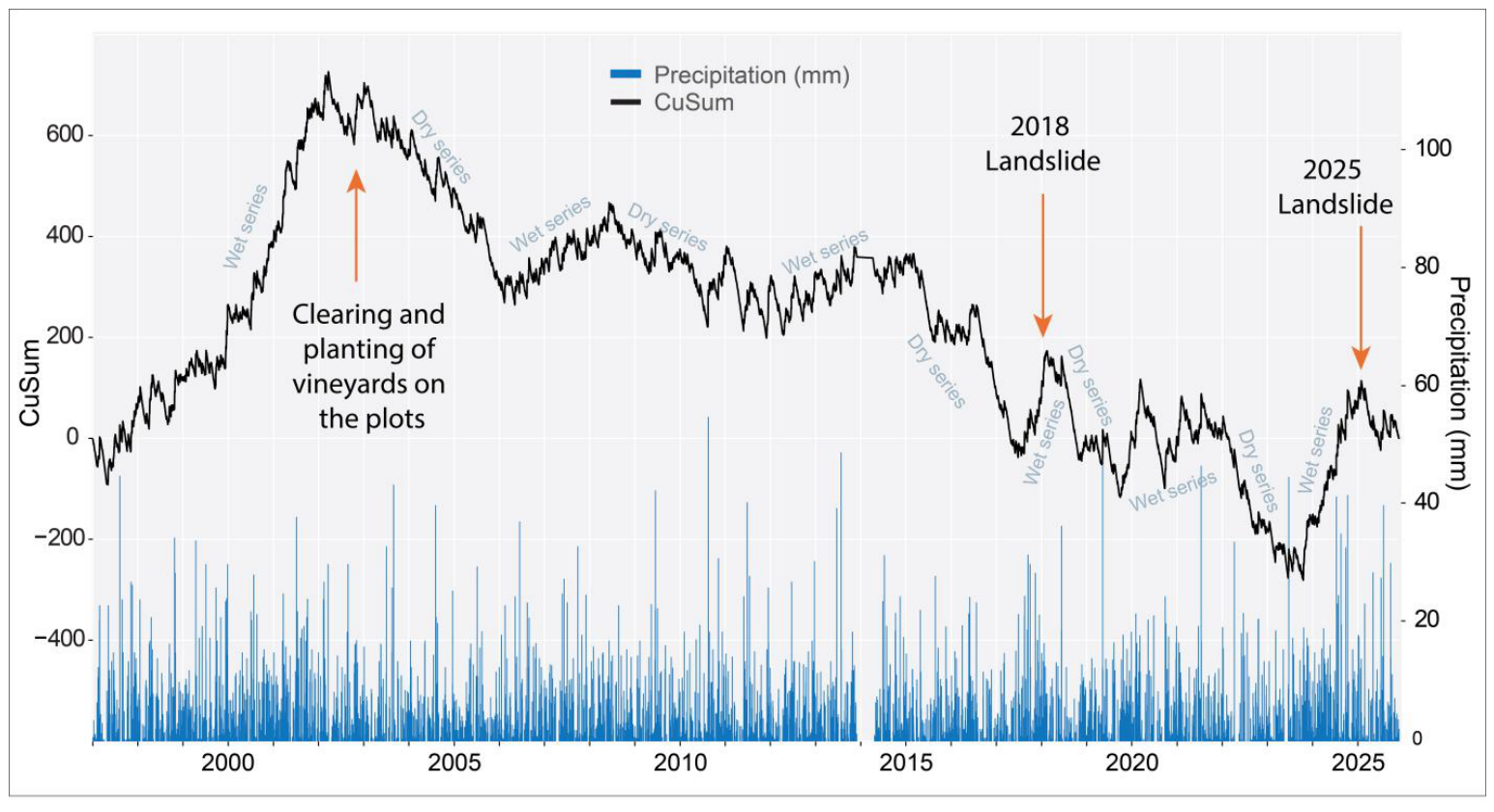
The results were also compared with climatic records from the Dizy station, located 10 km east of the Jacotines landslide, in an identical and homogeneous setting (Marne Valley, similar elevations, etc.). To understand climate trends, a CuSum (which corresponds to the cumulative sum compared to the cumulative mean of the observation period) is calculated (RStudio V 2024.12+467) [52]. This distinguishes dry and wet periods likely to influence landslide triggering and activity [18,20]. This method allows for analysis over a long time scale and thus places landslide activity within a broader climatic context.

4. Results

4.1. Evolution of the Landslide Area Using Photogrammetry and LiDAR Analysis

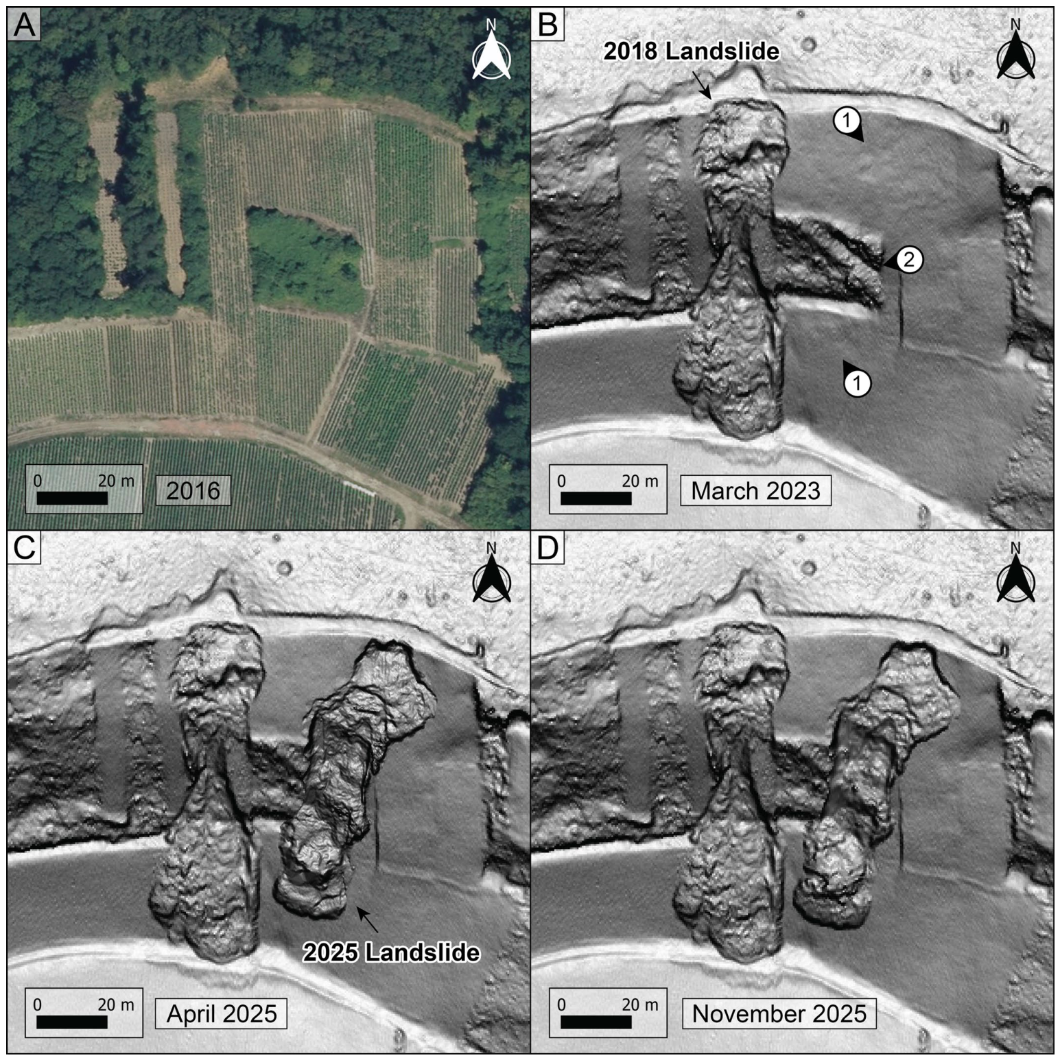
The two recent landslides in Reuil affect the slopes of the Marne Valley at the top of the Jacotines landslide [19] (Figure 4). They occur within undifferentiated Bartonian and Lutetian clays, marls, and limestones on vineyard plots with slopes averaging 22°, representing the steepest slopes in the study area. The first landslide occurred in February 2018, affecting an area approximately 100 m long and 20 m wide, for a total area of 2270 m2, of which 80% is vineyard and 20% forest (Figure 4A,B). The second landslide occurred in February 2025 and extended over 85 m in length and approximately 20 m in width, covering a total area of 1886 m2, 70% of which is vineyard (Figure 4B–D).
Figure 4. (A) Aerial view of the vineyard plots before the landslides; (B) Landslide in Reuil as seen by LiDAR imaging in 2023. (1) Deformation zones, (2) Former path; (C) Landslides in Reuil in April 2025; (D) Landslides in Reuil in November 2025.
The two landslides in Reuil thus share similar morphological characteristics: starting zones located at the edge of the plateau at a similar elevation, and flows—composed of heterogeneous materials—that come to a halt not far from the road below (which local winegrowers have had to clear on several occasions to allow passage). Both events showed a relatively rapid main displacement phase with significant movements occurring within hours to a day according to winegrowers’ accounts, which distinguishes them from certain slower events in the region [18,20]. On the March 2023 LiDAR image, in addition to the 2018 landslide, slight deformations at the 2025 landslide site are visible, likely indicating pre-failure deformation prior to the main displacement phase, and thus the initially unstable nature of the area (Figure 4B).
An old path is visible on the HD LiDAR; it was partially filled in during the vineyard installation work and is now intersected by the 2025 landslide (Figure 4B). A clear contrast in surface roughness between the vineyard plots and the forested plots is evident. The vineyard plots appear smoother than the forested areas, a result of reprofiling and backfilling the plots to facilitate vineyard management. Today, following the two landslides, the entire area is difficult to cultivate and partially inaccessible to winegrowers.
Direct observation of DTMs allows for an assessment of slope changes from a planimetric perspective. The analysis of the evolution of the Reuil landslides was conducted by comparing the 2023 HD LiDAR DTM with photogrammetric DTMs from aerial photography campaigns done by drone in April and November 2025. This makes it possible to track the evolution of the landslides between March 2023 and April 2025, as well as between April 2025 and November 2025.
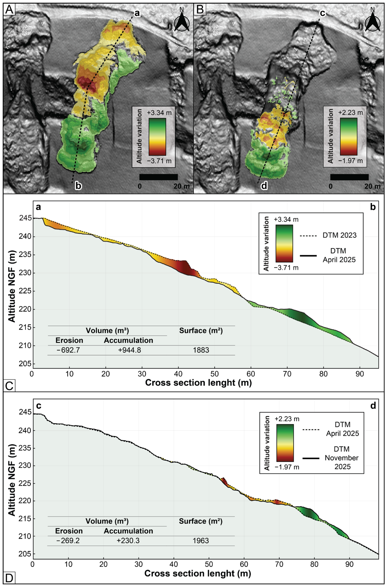
The comparison of the DTMs and field surveys shows that the two Reuil landslides are shallow; the sliding surfaces do not exceed 4 m in depth (a maximum of 3.71 m for the 2025 landslide; Figure 5A,C).
Photogrammetry reveals that the 2025 landslide occurred in two stages. First, an initial north–south-trending landslide began in the uppermost part of the slope. This initial section was then intersected on its western side by a second starting zone midway up the slope, which corresponds to the main propagation zone where up to 3.34 m of material accumulated. In total, the 2025 landslide involved volumes of approximately 944 m3. Calculations indicate −692.7 m3 of material displaced upstream and +944.8 m3 accumulated downstream (Figure 5A,C). The volume difference is due to material expansion, corresponding to a swelling coefficient of approximately 30% [53,54,55,56]. In fact, as they move, the materials involved in the landslide undergo decompression, which effectively increases their volume.
Figure 5. (A) Planimetric evolution of the Reuil landslide of 2025 between March 2023 and April 2025; (B) Planimetric evolution of the Reuil landslide between April 2025 and November 2025; (C) Cross-sectional evolution of the Reuil landslide between March 2023 and April 2025; (D) Cross-sectional evolution of the Reuil landslide between April 2025 and November 2025.
Between April and November 2025, the landslide propagated an additional 2.5 m (Figure 5B,D). From an altimetric perspective, a maximum elevation loss of 1.97 m is observed, while accumulations can exceed +2.23 m. In total, the differences in elevation correspond to approximately 250 m3 of displaced material, mainly in the lower part of the landslide, and represent an additional propagation of +80 m2. The uppermost part of the destabilized zone, however, shows no displacement.

4.2. Land-Use Change

According to winegrowers, landslides in the region generally occur at the top of the slope, on the steepest sections (which often correspond to the main escarpment of former large-scale rotational landslides). These areas share the common feature of being recent vineyard plots established after land clearing and planting since the 1990s, 2000s, or even the 2010s. Across the entire Champagne AOC, the Champagne vineyards expanded rapidly from the post-war period through the 1980s [57], accompanying the industry’s growth primarily on easily accessible slopes. During this period, the AOC’s vineyard area grew from approximately 11,000 hectares to over 34,000 hectares today.
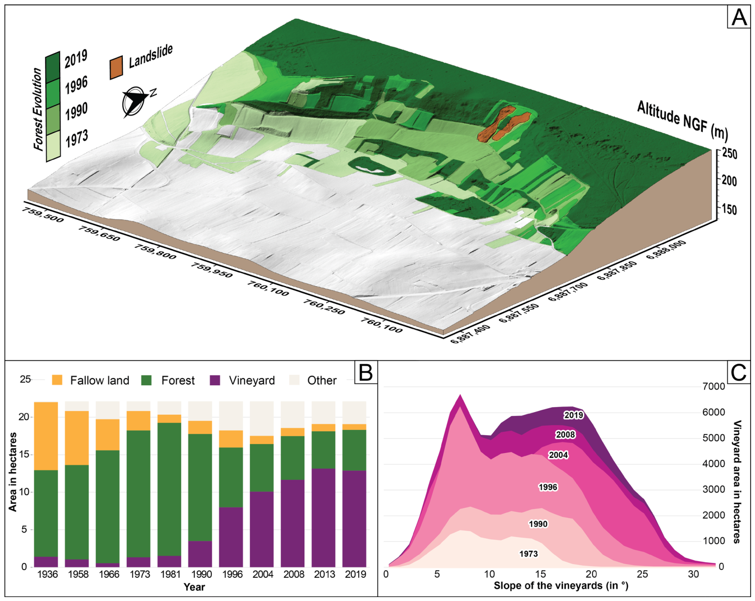
In Reuil, through aerial photo interpretation and land-cover digitization, it is possible to quantify forest clearing and subsequent vineyard establishment in areas affected by landslides (Figure 6A). Along the scarp of the large, ancient Jacotines landslide, forest cover has gradually decreased since the 1990s (Figure 6B). Plots left fallow for nearly 40 years became predominantly forested by the 1980s. Vineyard planting began in the 1990s with the gradual clearing of the forest, reaching the boundaries of the Champagne AOC area in 2013. The slight decrease observed in 2019 corresponds to the area affected by the 2018 landslide. The two landslides occurred in the only wine-growing enclave in this area included in this initiative.
These areas affected by recent landslides also correspond to the steepest slopes. Human pressure on the vineyard plots reveals that cultivation is expanding onto increasingly steep slopes (Figure 6C). Since the 2000s, vineyards have gradually expanded to plots higher and higher up the slopes, with slopes often exceeding 8° and reaching up to 30° [58]. Despite the challenges of cultivation, these plots represent the last available land within the AOC. Anthropogenic pressure here is characterized by the expansion of vines onto increasingly steep slopes. In the 1970s, vineyards were mainly located on slopes of less than 15°, a trend that continued until the late 1990s. From 2004 onwards, cultivation of slopes steeper than 15° increased sharply. This trend continued through 2019, reaching slopes steeper than 25°, resulting in a bimodal distribution of slope values in the study area (Figure 6C). The 2018 and 2025 landslides occurred in this recently cleared, and therefore steep, area.
Figure 6. (A) Block diagram showing the evolution of the forest on the Jacotines landslide scarp; (B) Evolution of land use on the Jacotines landslide scarp; (C) Evolution of the vineyard area on the Jacotines landslide scarp according to slope.

4.3. Analysis of Climatic Conditions

An analysis of land use shows that the Reuil landslides occurred only in the cleared areas of the study area. To understand the timing of their triggering, an analysis of climatic conditions is needed.
The 2018 landslide was triggered by a period of heavy rainfall that lasted several days in January 2018. January 2018 was indeed particularly rainy (145 mm, or 252% of the region’s monthly average of 57.44 mm). This period followed a period of lighter or more scattered rainfall. The 2015 landslide also followed a period of heavy rainfall. That period was shorter but more intense, with 5 days in particular when daily rainfall exceeded 30 mm (Figure 7).
In addition, the precipitation CuSum allows us to identify sequences of dry periods, such as those between 2003–2007 and 2015–2017, as well as sequences of wet periods, such as before 2002, between 2018 and 2019, and between 2023 and 2025 (Figure 6). The Reuil landslides were triggered by wet periods following dry periods (2018 and 2025). In 2018, the wet period was abrupt (steep slope of the CuSum curve) and followed a prolonged, predominantly dry period between 2002 and 2017. In 2025, the landslide was also triggered during a predominantly wet period that began in 2024 and followed a very dry period between 2022 and 2024. Thus, episodic events are not sufficient to trigger instability despite the steep slopes. Landslides are primarily triggered following a succession of dry and wet years. This is consistent with the overall behavior of landslides previously identified across the vineyard area [18,59].
Figure 7. CuSum Plot of Precipitation and Daily Precipitation, Based on Data from the Dizy Weather Station (1987–2025).

5. Discussion

The two landslides in Reuil occurred in the only area that has been continuously cleared along the full height of the main scarp zone of the large, long-standing Jacotines landslide [16,17]. These plots have an average slope of 22° and were cleared in 2004. Less than 15 years after the completion of land clearing and the start of cultivation on these plots, the first landslide occurred in January 2018 following a relatively wet year that followed a prolonged, generally dry period since the land was cleared. The second landslide occurred in February 2025, also triggered under favorable climatic conditions: a very wet year following a drier period since 2018. This behavior has already been observed in the Champagne vineyard region [18,20], as well as in similar regions in northern France [4,5].
In the Champagne vineyards, some landslides occur in forested areas, indicating that steep slopes are unstable; however, the majority affect slopes—or sections of slopes—planted with vines (accounting for approximately 90% of the landslides recorded over the past 10 years). Landslides therefore appear to have been the result of a combination of factors: first, structural controls, characterized by favorable geological conditions and steep slopes; and second, climatic factors, particularly wet periods following dry periods, creating strong contrasts in water availability. This forcing should be exacerbated by anthropogenic pressure; land clearing for vineyard cultivation leads to localized slope instabilities shortly after planting, which seems to reduce the slope’s stability.
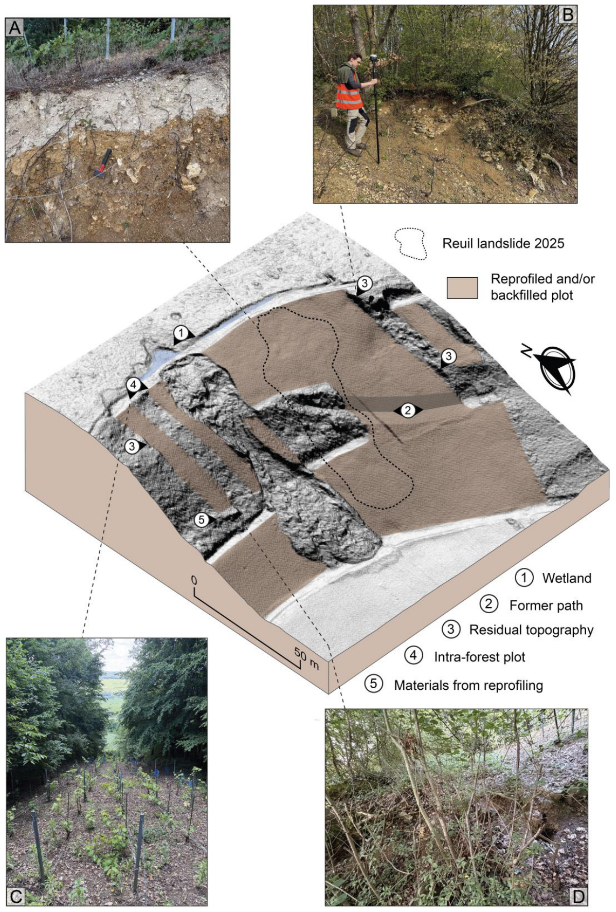
Furthermore, vineyard plantings in Champagne are systematically accompanied by backfilling of varying magnitude (ranging from a few dozen centimeters to several meters) and slope reprofiling, with the aim of reducing natural slope irregularities to optimize vine exposure and facilitate vineyard management (e.g., passage of motorized equipment…; Figure 8). It is also common for plots to be reworked after a landslide to restore a regular slope profile without implementing proper stabilization measures or prior studies, sometimes even in defiance of the strict regulations set forth in the AOC specifications.
Figure 8. Block diagram of the backfilling and reprofiling of the Reuil plots based on LiDAR HD 2023; (A) 2025 landslide escarpment; (B) Residual Topography; (C) Vineyard plot in the forest; (D) Materials resulting from reprofiling operations in forest plots.
As such, the plots in Reuil located on the scarp zone of the large, ancient Jacotines landslide have also been significantly reshaped. Differences in land use are clearly identifiable from surface texture: the vineyard plots are smooth, while the forested plots are rough. The slope’s topography has been partially reprofiled, as evidenced by the residual topographic features along the edges of the plots and the accumulation of material at the base of the forested plots (Figure 8). These slope works affect the cohesion of the underlying materials alters subsurface water flow, particularly since, upslope of the Reuil landslides, wetlands are present which may contribute to water supply in the landslide area. An old path has also been partially filled in to provide continuity along the slope. These works, intended to facilitate farming practices, tend to exacerbate slope instabilities. Thus, they are primarily composed of heterogeneous fill material (siliceous clays, chalky soils, etc.) brought in during the slope reprofiling process, aimed at reducing natural slope irregularities and facilitating vineyard management (Figure 8).

6. Conclusions

The landslides that occurred in Reuil in 2018 and 2025 affected steeply sloped plots recently cleared and backfilled for vineyard cultivation. Under climatic forcing, these plots became unstable, causing considerable damage in an area where land prices exceed one million euros per hectare. Landslides therefore result from multiple controlling factors. First, the geological setting (presence of clays and marls) on steep slopes is conducive to instabilities. Landslides are triggered by climatic forcing, manifested as wet periods following dry periods, creating strong contrasts in water availability [18,58]. This forcing seems exacerbated by anthropogenic pressure now exerted on the steepest plots within the AOC area, particularly due to the clearing of forested plots for vineyard cultivation. This leads to localized slope instabilities after cultivation begins. In the future, this should prompt further reflection on the management of vineyard plots to ensure greater slope stability.
This pattern is frequently observed across the Champagne vineyards, where landslides commonly occur in the upper parts of slopes, which were historically left forested because they were too difficult to cultivate. The region’s economic appeal thus leads to significant anthropogenic pressure on the slopes, which is partly responsible for numerous instances of instabilities. This pressure compounds the climatic forcing exacerbated by global changes, which also tend to increase the number of instability events in the Champagne vineyards [18].

Author Contributions

Conceptualization, A.B. and N.B.; methodology, A.B., T.K. and J.B.; software, A.B., T.K. and J.B.; validation, A.B. and N.B.; formal analysis, A.B. and N.B.; investigation, A.B., T.K., J.B. and D.C.; resources, N.B., A.D. and O.L.; data curation, T.K., J.B. and A.B.; writing—original draft preparation, A.B. and N.B.; writing—review and editing, A.B., N.B. and T.K.; visualization, A.B.; supervision, N.B. and A.B.; project administration, N.B. All authors have read and agreed to the published version of the manuscript.

Funding

This research received no external funding.

Data Availability Statement

The original contributions presented in this study are included in the article. Further inquiries can be directed to the corresponding author.

Conflicts of Interest

The authors declare no conflicts of interest.

Abbreviations

The following abbreviations are used in this manuscript:
DTMDigital Terrain Model
DoDDifferentials of DEM
MinLoDMinimum Limit of Detection
RTKReal Time Kinematic
GCPGround Control Point
RMSERoot-Mean-Square Error
IGNInstitut National de l’information Géographique et forestière
AOCAppellation d’Origine Contrôlée

References

  1. Dikau, R.; Brunsden, D.; Schrott, L.; Ibsen, M.-L. Landslides Recognition: Identification, Movements and Causes; John Wiley and Sons: Chichester, UK, 1996; 251p. [Google Scholar] [CrossRef] [Scilit]
  2. Demoulin, A.; Pissart, A.; Schroeder, C. On the origin of late Quaternary palaeolandslides in the Liège (E Belgium) area. Int. J. Earth Sci. 2003, 92, 795–805. [Google Scholar] [CrossRef] [Scilit]
  3. Hadji, R.; Limani, Y.; Baghem, M.; el Madjid Chouabi, A.; Demdoum, A. Geologic, topographic and climatic controls in landslide hazard assessment using GIS modeling: A case study of Souk Ahras region, NE Algeria. Quat. Int. 2013, 302, 224–237. [Google Scholar] [CrossRef] [Scilit]
  4. Fressard, M.; Maquaire, O.; Thiery, Y.; Davidson, R.; Lissak, C. Multi-method characterisation of an active landslide: Case study in the Pays d’Auge plateau (Normandy, France). Geomorphology 2016, 270, 22–39. [Google Scholar] [CrossRef] [Scilit]
  5. Thirard, G.; Grandjean, G.; Thiery, Y.; Maquaire, O.; François, B.; Lissak, C.; Costa, S. Hydrogeological assessment of a deep-seated coastal landslide based on a multidisciplinary approach. Geomorphology 2020, 371, 107440. [Google Scholar] [CrossRef] [Scilit]
  6. Fang, Z.; Morales, A.B.; Wang, Y.; Lombardo, L. Climate change has increased rainfall-induced landslide damages in central China. Int. J. Disaster Risk Reduct. 2025, 119, 105320. [Google Scholar] [CrossRef] [Scilit]
  7. Ramzan, M.; Cui, P.; Ualiyeva, D.; Mukhtar, H.; Bazai, N.A.; Baig, M.A. Impact of climate change on landslides along N-15 Highway, northern Pakistan. Adv. Clim. Change Res. 2025, 16, 397–408. [Google Scholar] [CrossRef] [Scilit]
  8. Pánek, T.; Hradecky, J.; Smolkova, V.; Silhan, K. Giant ancient landslide in the Alma water gap (Crimean Mountains, Ukraine): Notes to the predisposition structure, and chronology. Landslides 2008, 5, 367–378. [Google Scholar] [CrossRef] [Scilit]
  9. Pánek, T.; Hradecky, J.; Smolkova, V.; Silhan, K. Gigantic low-gradient landslides in the northern periphery of the Crimean Mountains (Ukraine). Geomorphology 2008, 95, 449–473. [Google Scholar] [CrossRef] [Scilit]
  10. Preuth, T.; Glade, T.; Demoulin, A. Stability analysis of a human-influenced landslide in eastern Belgium. Geomorphology 2010, 120, 38–47. [Google Scholar] [CrossRef] [Scilit]
  11. Vranken, L.; Van Turnhout, P.; Van Den Eeckhaut, M.; Vanderkerckhove, L.; Poesen, J. Economic valuation of landslide damage in hilly regions: A case study from Flanders, Belgium. Sci. Total Environ. 2013, 447, 323–336. [Google Scholar] [CrossRef] [Scilit] [PubMed]
  12. Neuhäuser, B.; Terhorst, B. Landslide susceptibility assessment using “weights-of-evidence” applied to a study area at the Jurassic escarpment (SW-Germany). Geomorphology 2007, 86, 12–24. [Google Scholar] [CrossRef] [Scilit]
  13. Sass, O.; Bell, R.; Glade, T. Comparison of GPR, 2D-resistivity and traditional techniques for the subsurface exploration of the Oshingen landslide, Swabian Alb (Germany). Geomorphology 2008, 93, 89–103. [Google Scholar] [CrossRef] [Scilit]
  14. Terhorst, B. Periglacial cover beds ans soils in landslide areas of SW-Germany. Catena 2007, 71, 467–476. [Google Scholar] [CrossRef] [Scilit]
  15. Van Den Eeckhaut, M.; Marre, A.; Poesen, J. Comparison of two landslide susceptibility assessments in the Champagne-Ardenne region (France). Geomorphology 2010, 11, 141–155. [Google Scholar] [CrossRef] [Scilit]
  16. Bollot, N.; Pierre, G.; Grandjean, G.; Fronteau, G.; Devos, A.; Lejeune, O. Internal Structure and Reactivations of a Mass Movement: The Case Study of the Jacotines Landslide (Champagne Vineyards, France). GeoHazards 2023, 4, 183–196. [Google Scholar] [CrossRef] [Scilit]
  17. Ortonovi, S.; Bollot, N.; Pierre, G.; Deroin, J.P. Apport de la télédétection à l’analyse des glissements de terrain du vignoble champenois entre Epernay et Dormans (Marne, France). Géomorphol. Relief Process. Environ. 2021, 2, 147–158. [Google Scholar] [CrossRef] [Scilit]
  18. Bollot, N.; Benoit, A.; Berthe, J.; Combaz, D.; Krauffel, T.; Devos, A.; Lejeune, O.; Ancelin, P.-Y. Analysis of the Evolution of Lowland Landslides in Temperate Environments According to Climatic Conditions Based on LiDAR Data: A Case Study from Rilly (Champagne Vineyard Region, Northeastern France). Geosciences 2025, 15, 191. [Google Scholar] [CrossRef] [Scilit]
  19. Ling, C.; Xu, Q.; Zhang, Q.; Ran, J.; Lv, H. Application of electrical resistivity tomography for investigating the internal structure of a translational landslide and characterizing its groundwater circulation (Kualiangzi landslide, Southwest China). J. Appl. Geophys. 2016, 131, 154–162. [Google Scholar] [CrossRef] [Scilit]
  20. Bollot, N.; Pierre, G.; Devos, A.; Lutz, P.; Ortonovi, S. Hydrogeology of a landslide: A case study in the Montagne de Reims (Paris basin, France). Q. J. Eng. Geol. Hydrogeol. 2022, 56, 2021–2041. [Google Scholar] [CrossRef] [Scilit]
  21. Williams, R. DEMs of Difference. Geomorphol. Tech. 2012, 2, 1–17. [Google Scholar]
  22. Lague, D.; Brodu, N.; Leroux, J. Accurate 3D comparison of complex topography with terrestrial laser scanner: Application to the Rangitikei canyon (NZ). ISPRS J. Photogramm. Remote Sens. 2013, 82, 10–26. [Google Scholar] [CrossRef] [Scilit]
  23. Lu, X.; Li, Y.; Washington-Allen, R.A.; Li, Y. Structural and sedimentological connectivity on a rilled hillslope. Sci. Total Environ. 2019, 655, 1479–1494. [Google Scholar] [CrossRef] [Scilit] [PubMed]
  24. Bailey, G.; Li, Y.; McKinney, N.; Yoder, D.; Wright, W.; Washington-Allen, R. Las2DoD: Change Detection Based on Digital Elevation Models Derived from Dense Point Clouds with Spatially Varied Uncertainty. Remote Sens. 2022, 14, 1537. [Google Scholar] [CrossRef] [Scilit]
  25. Dewitte, O.; Jasselette, J.C.; Cornet, Y.; Van Den Eeckhaut, M.; Collignon, A.; Poesen, J.; Demoulin, A. Tracking landslide displacements by multi-temporal DTMs: A combined aerial stereophotogrammetric and LIDAR approach in western Belgium. Eng. Geol. 2008, 99, 11–22. [Google Scholar] [CrossRef] [Scilit]
  26. Mora, O.E.; Lenzano, M.G.; Toth, C.K.; Grejner-Brzezinska, D.A.; Fayne, J.V. Landslide change detection based on multi-temporal Airborne LiDAR-derived DEMs. Geosciences 2018, 8, 23. [Google Scholar] [CrossRef] [Scilit]
  27. Hung, C.L.; Tseng, C.W.; Huang, M.J.; Tseng, C.M.; Chang, K.J. Multi-temporal high-resolution landslide monitoring based on uas photogrammetry and uas lidar geoinformation. Int. Arch. Photogramm. Remote Sens. Spat. Inf. Sci. 2019, 42, 157–160. [Google Scholar] [CrossRef] [Scilit]
  28. Sestras, P.; Badea, G.; Badea, A.C.; Salagean, T.; Oniga, V.E.; Roșca, S.; Bilașco, Ș.; Bruma, S.; Spalević, V.; Billi, P.; et al. A novel method for landslide deformation monitoring by fusing UAV photogrammetry and LiDAR data based on each sensor’s mapping advantage in regards to terrain feature. Eng. Geol. 2025, 346, 107890. [Google Scholar] [CrossRef] [Scilit]
  29. Berthe, J. Apport du LiDAR Aéroporté à la Compréhension des Hydrosystèmes—Exemple de la Montagne de Reims. Ph.D. Thesis, Université de Reims Champagne-Ardenne, Reims, France, 2024; 412p. Available online: https://theses.hal.science/tel-04491099v1 (accessed on 29 August 2024).
  30. Hengl, T. Finding the right pixel size. Comput. Geosci. 2006, 32, 1283–1298. [Google Scholar] [CrossRef] [Scilit]
  31. Jaud, M.; Bertin, S.; Beauverger, M.; Augereau, E.; Delacourt, C. RTK GNSS-assisted terrestrial SfM photogrammetry without GCP: Application to coastal morphodynamics monitoring. Remote Sens. 2020, 12, 1889. [Google Scholar] [CrossRef] [Scilit]
  32. Ancelin, J.; Ladet, S.; Heintz, W. Le Real Time Kinematic collaboratif, lowcost et open source. Positionnement GNSS temps réel, cinématique, collaboratif et en accès libre et à faible coût. In Spatial Analysis and GEOmatics 2023; Centre de Recherche en Données et Intelligence Géospatiales de l’Université Laval: Quebec, QC, Canada, 2023; pp. 184–197. Available online: https://ut3-toulouseinp.hal.science/hal-04144737/ (accessed on 6 March 2026).
  33. Dabove, P.; Bagheri, M. Enhancing atmospheric monitoring capabilities: A comparison of low-and high-cost GNSS networks for tropospheric estimations. Remote Sens. 2024, 16, 2223. [Google Scholar] [CrossRef] [Scilit]
  34. Ancelin, J.; Ladet, S.; Heintz, W. CentipedeRTK, un réseau pour la géolocalisation haute précision au service de l’environnement. J. Interdiscip. Methodol. Issues Sci. 2025, 12, 14252. [Google Scholar] [CrossRef] [Scilit]
  35. Walstra, J.; Chandler, J.; Dixon, N.; Dijkstra, T. Aerial photography and digital photogrammetry for landslide monitoring. Geol. Soc. Lond. Spec. Publ. 2007, 283, 53–63. [Google Scholar] [CrossRef] [Scilit]
  36. Stumpf, A.; Malet, J.P.; Allemand, P.; Pierrot-deseilligny, M.; Skupinski, G. Ground-based multi-view photogrammetry for the monitoring of landslide deformation and erosion. Geomorphology 2015, 231, 130–145. [Google Scholar] [CrossRef] [Scilit]
  37. Fernandez, T.; Perez, J.L.; Colomo, C.; Cardenal, J.; Delgado, J.; Palenzuela, J.A.; Irigaray, C.; Chacon, J. Assessment of the evolution of a landslide using digital photogrammetry and LiDAR techniques in the Alpujarras region (Granada, southeastern Spain). Geosciences 2017, 7, 32. [Google Scholar] [CrossRef] [Scilit]
  38. Cheng, Z.; Gong, W.; Tang, H.; Juang, C.H.; Deng, Q.; Chen, J.; Ye, X. UAV photogrammetry-based remote sensing and preliminary assessment of the behavior of a landslide in Guizhou, China. Eng. Geol. 2021, 289, 106172. [Google Scholar] [CrossRef] [Scilit]
  39. Domínguez-Cuesta, M.J.; Rodríguez-Rodríguez, L.; López-Fernández, C.; Pando, L.; Cuervas-Mons, J.; Olona, J.; González-Pumariega, P.; Serrano, J.; Valenzuela, P.; Jiménez-Sánchez, M. Using Remote Sensing Methods to Study Active Geomorphologic Processes on Cantabrian Coastal Cliffs. Remote Sens. 2022, 14, 5139. [Google Scholar] [CrossRef] [Scilit]
  40. Zhan, X.; Zhang, X.; Wang, X.; Diao, X.; Qi, L. Comparative analysis of surface deformation monitoring in a mining area based on UAV-lidar and UAV photogrammetry. Photogramm. Rec. 2024, 39, 373–391. [Google Scholar] [CrossRef] [Scilit]
  41. Liang, Z.; Gabrieli, F.; Pol, A.; Brezzi, L. Automated Photogrammetric Tool for Landslide Recognition and Volume Calculation Using Time-Lapse Imagery. Remote Sens. 2024, 16, 3233. [Google Scholar] [CrossRef] [Scilit]
  42. Cardenal, J.; Mata, E.; Perez-garcia, J.L.; Delgado, J.; Andez, M.; Gonzalez, A.; Diaz-de-teran, J.R. Close range digital photogrammetry techniques applied to landslide monitoring. Int. Arch. Photogramm. Remote Sens. Spat. Inf. Sci. 2008, 37, 235–240. [Google Scholar]
  43. Carvajal, F.; Agüera, F.; Perez, M. Surveying a landslide in a road embankment using unmanned aerial vehicle photogrammetry. Int. Arch. Photogramm. Remote Sens. Spat. Inf. Sci. 2012, 38, 201–206. [Google Scholar] [CrossRef] [Scilit]
  44. Terpstra, T.; Dickinson, J.; Hashemian, A.; Fenton, S. Reconstruction of 3D Accident Sites Using USGS LiDAR, Aerial Images, and Photogrammetry; No. 2019-01-0423; SAE Technical Paper; SAE International: Warrendale, PA, USA, 2019. [Google Scholar] [CrossRef] [Scilit]
  45. Leem, J.; Kim, J.; Choi, J.; Song, J.J. Comparison of an underground rock face 3D modeling performance: SfM-MVS with optimum photographing settings and LiDAR technology. In Proceedings of the 15th ISRM Congress, Salzburg, Austria, 9–14 October 2023; ISRM: Lisbon, Portugal, 2023. [Google Scholar]
  46. Brasington, J.; Rumsby, B.T.; McVey, R.A. Monitoring and modelling morphological change in a braided gravel-bed river using high resolution GPS-based survey. Earth Surf. Process. Landf. J. Br. Geomorphol. Res. Group 2000, 25, 973–990. [Google Scholar] [CrossRef]
  47. Brasington, J.; Langham, J.; Rumsby, B. Methodological sensitivity of morphometric estimates of coarse fluvial sediment transport. Geomorphology 2003, 53, 299–316. [Google Scholar] [CrossRef] [Scilit]
  48. Wheaton, J.M.; Brasington, J.; Darby, S.E.; Sear, D.A. Accounting for uncertainty in DEMs from repeat topographic surveys: Improved sediment budgets. Earth Surf. Process. Landf. J. Br. Geomorphol. Res. Group 2010, 35, 136–156. [Google Scholar] [CrossRef] [Scilit]
  49. Vericat, D.; Smith, M.W.; Brasington, J. Patterns of topographic change in sub-humid badlands determined by high resolution multi-temporal topographic surveys. Catena 2014, 120, 164–176. [Google Scholar] [CrossRef] [Scilit]
  50. James, M.R.; Robson, S.; Smith, M.W. 3D uncertainty-based topographic change detection with structure-from-motion photogrammetry: Precision maps for ground control and directly georeferenced surveys. Earth Surf. Process. Landf. 2017, 42, 1769–1788. [Google Scholar] [CrossRef] [Scilit]
  51. Wang, R.; Sun, H.; Yang, J.; Zhang, S.; Fu, H.; Wang, N.; Liu, Q. Quantitative Evaluation of Gully Erosion Using Multitemporal UAV Data in the Southern Black Soil Region of Northeast China: A Case Study. Remote Sens. 2022, 14, 1479. [Google Scholar] [CrossRef] [Scilit]
  52. Page, E.S. Continuous inspection schemes. Biometrika 1954, 41, 100–115. [Google Scholar] [CrossRef] [Scilit]
  53. Martha, T.R.; Kerle, N.; Jetten, V.; Van Westen, C.J.; Kumar, K.V. Landslide volumetric analysis using Cartosat-1-derived DEMs. IEEE Geosci. Remote Sens. Lett. 2010, 7, 582–586. [Google Scholar] [CrossRef] [Scilit]
  54. Turner, D.; Lucieer, A.; De Jong, S.M. Time Series Analysis of Landslide Dynamics Using an Unmanned Aerial Vehicle (UAV). Remote Sens. 2015, 7, 1736–1757. [Google Scholar] [CrossRef] [Scilit]
  55. Ma, S.Y.; Xu, C.; Xu, X.W. Volume expansion rates of seismic landslides and influencing factors: A case study of the 2008 Wenchuan earthquake. J. Mt. Sci. 2019, 16, 1731–1742. [Google Scholar] [CrossRef] [Scilit]
  56. Yang, D.; Qiu, H.; Hu, S.; Pei, Y.; Wang, X.; Du, C.; Long, Y.; Cao, M. Influence of successive landslides on topographic changes revealed by multitemporal high-resolution UAS-based DEM. Catena 2021, 202, 105229. [Google Scholar] [CrossRef] [Scilit]
  57. Marre, A. Existe-t-il des terroirs viticoles en Champagne? Rev. Géograph. l’Est 2004, 44, 17–30. [Google Scholar] [CrossRef] [Scilit]
  58. Bollot, N.; Devos, A.; Pierre, G. Ressources en eau et glissements de terrain: Exemple du bassin versant de la Semoigne (bassin de Paris, France). Géomorphol. Relief Process. Environ. 2015, 2, 121–132. [Google Scholar] [CrossRef] [Scilit]
  59. Combaud, A.; Cornuet, J.; Pargny, D.; Marre, A. Évolution des paysages viticoles champenois: Corrélations entre les paramètres historiques, humains et naturels dans le secteur de la Montagne de Reims. Actes Congrès Natx. Soc. Hist. Sci. 2011, 135, 67–80. [Google Scholar]
Disclaimer/Publisher’s Note: The statements, opinions and data contained in all publications are solely those of the individual author(s) and contributor(s) and not of MDPI and/or the editor(s). MDPI and/or the editor(s) disclaim responsibility for any injury to people or property resulting from any ideas, methods, instructions or products referred to in the content.

Article Metrics

Citations

Article Access Statistics

Multiple requests from the same IP address are counted as one view.