
Evaluation of Sentinel-2 Vegetation Indices for Estimating Leaf Area Index in Cassava Plots



Abstract
1. Introduction
2. Materials and Method
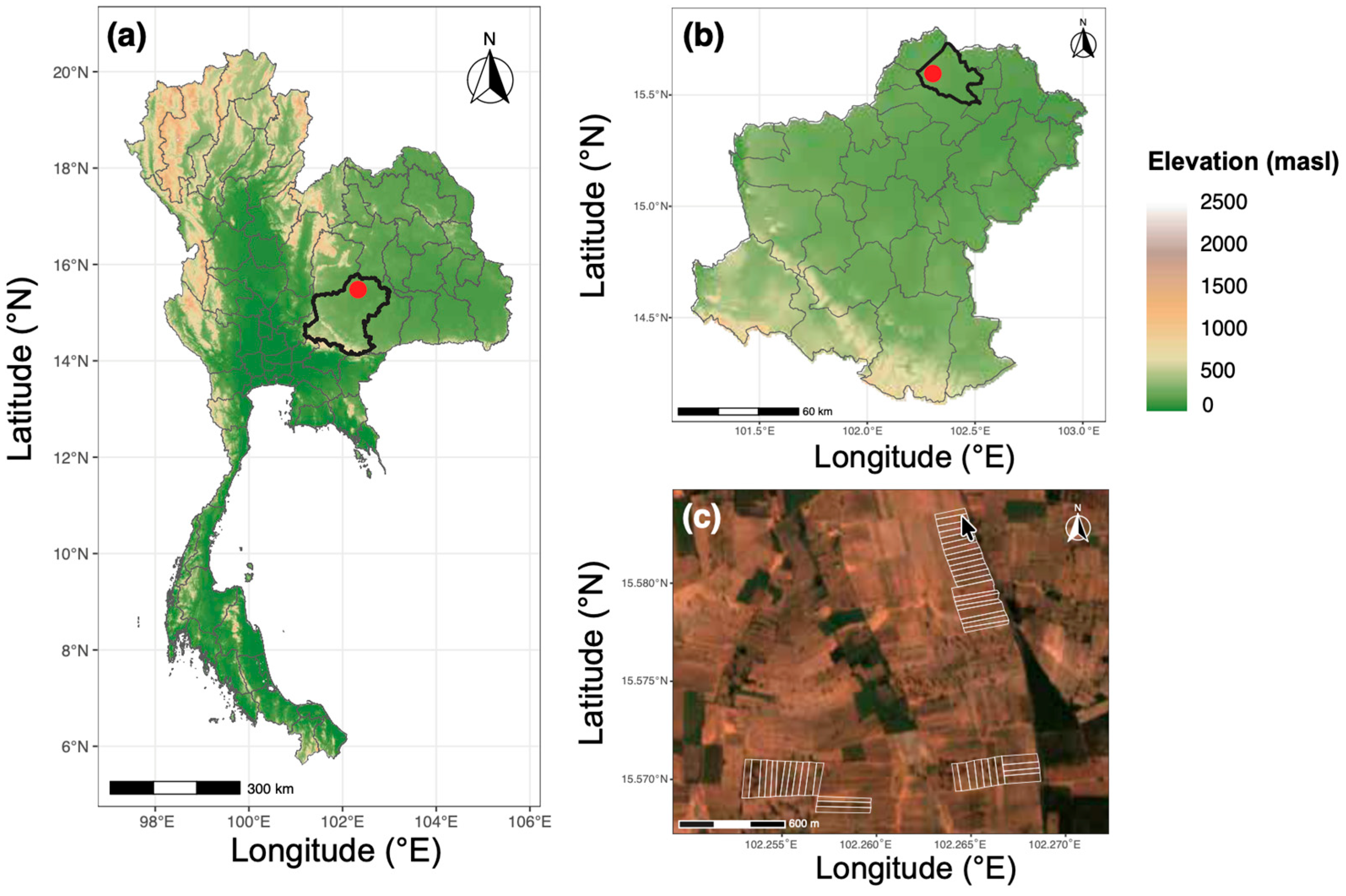
2.1. Study Site
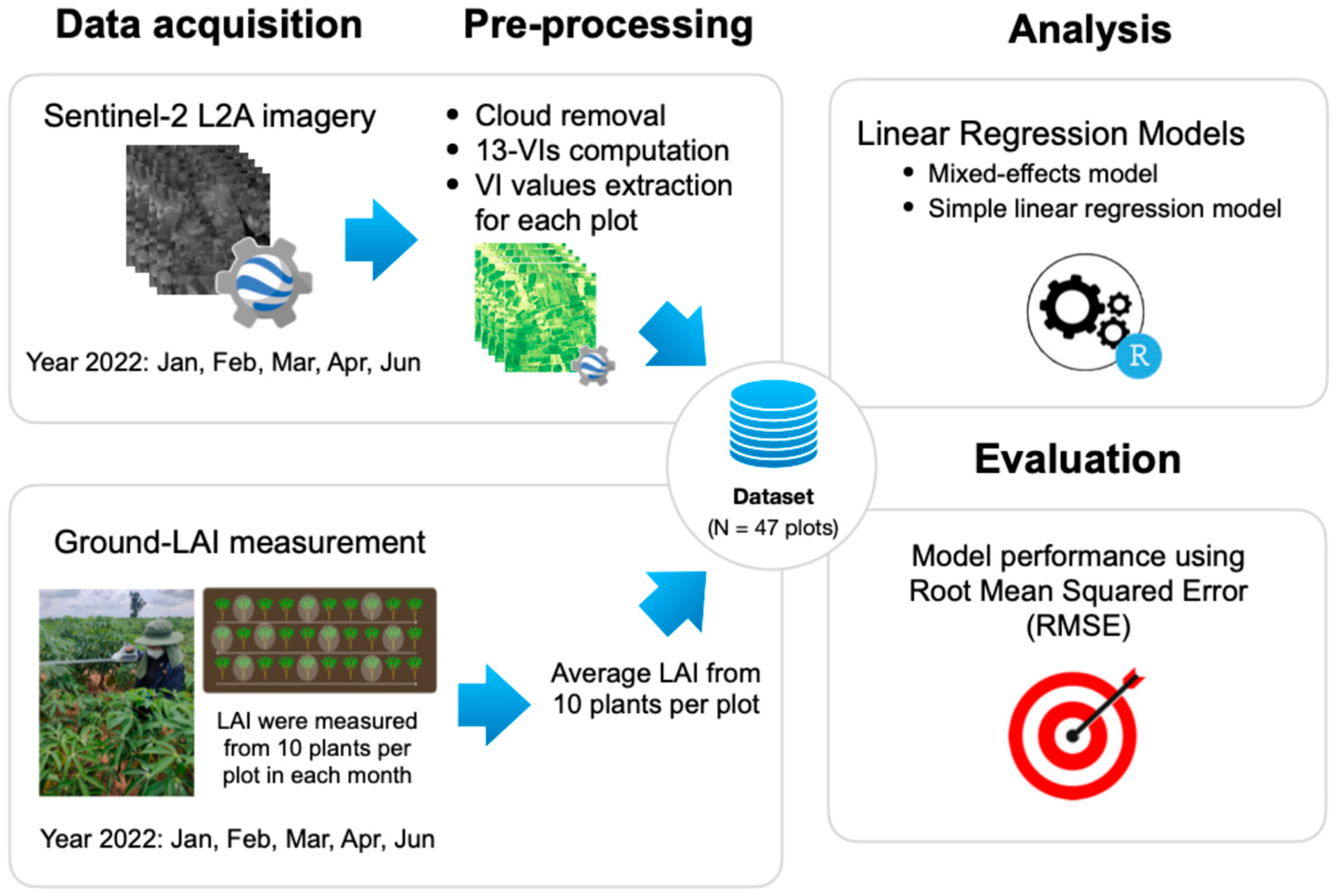
2.2. General Workflow and Ground-LAI Measurement
2.3. Preparation of Sentinel-2-Derived Vegetation Indices
2.3.1. Data Acquisition
2.3.2. Data Pre-Processing
2.3.3. Vegetation Indices (VIs) Computation
2.4. Statistical Analysis
2.4.1. Regression Analysis Between VIs and Ground–LAI
2.4.2. Evaluation Metrics of Model Performance
3. Results
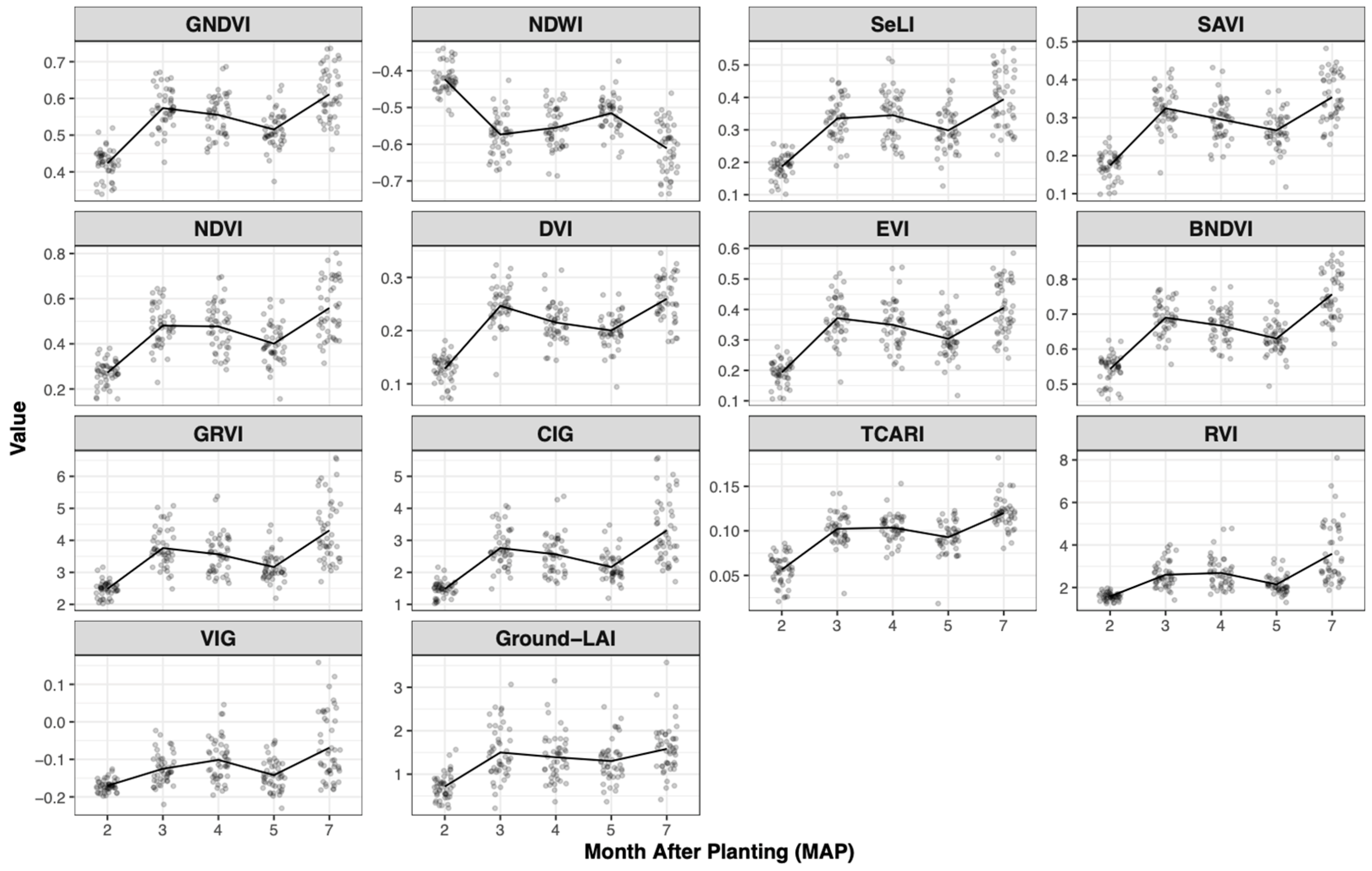
3.1. Temporal Patterns of Ground-LAI and Vegetation Indices
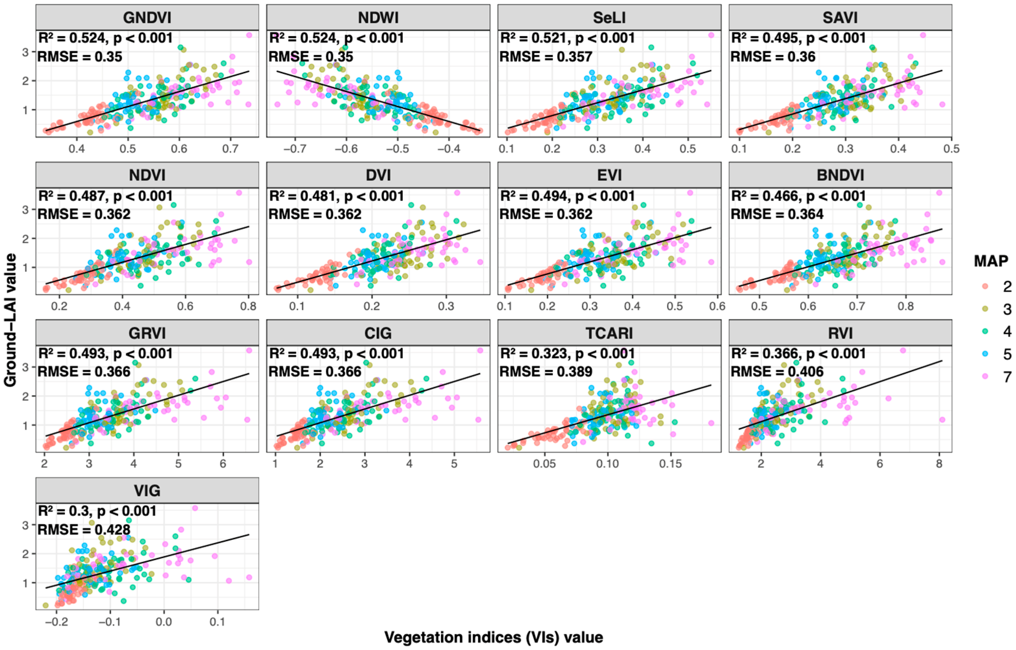
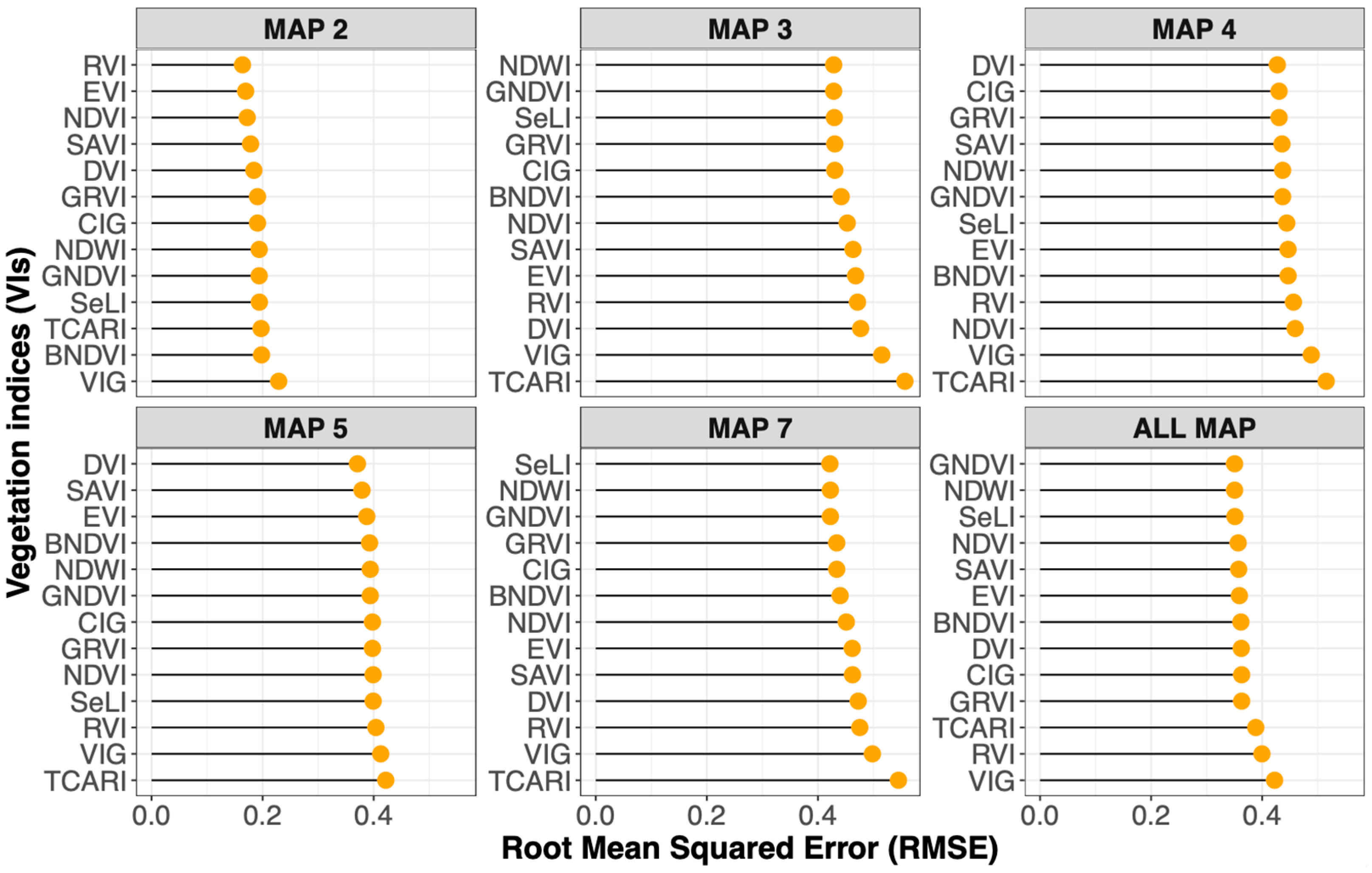
3.2. Predictive Performance of Vegetation Indices Across All Growth Stages
3.3. Stage-Specific Performance of Vegetation Indices
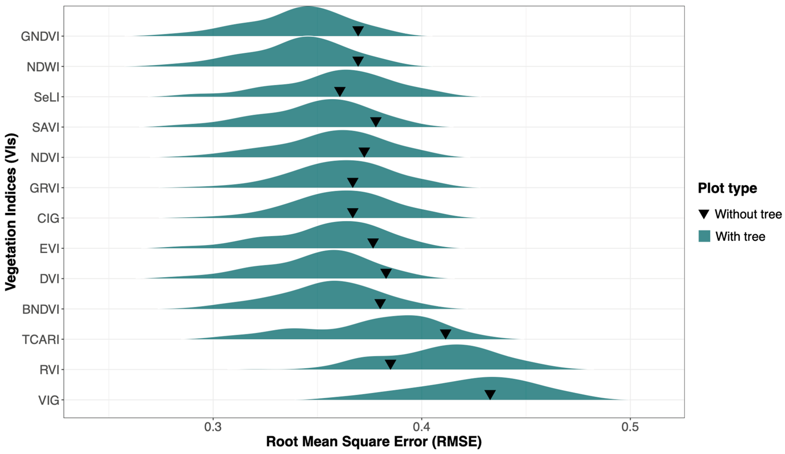
3.4. Model Performance Comparison by Plot Types
4. Discussion
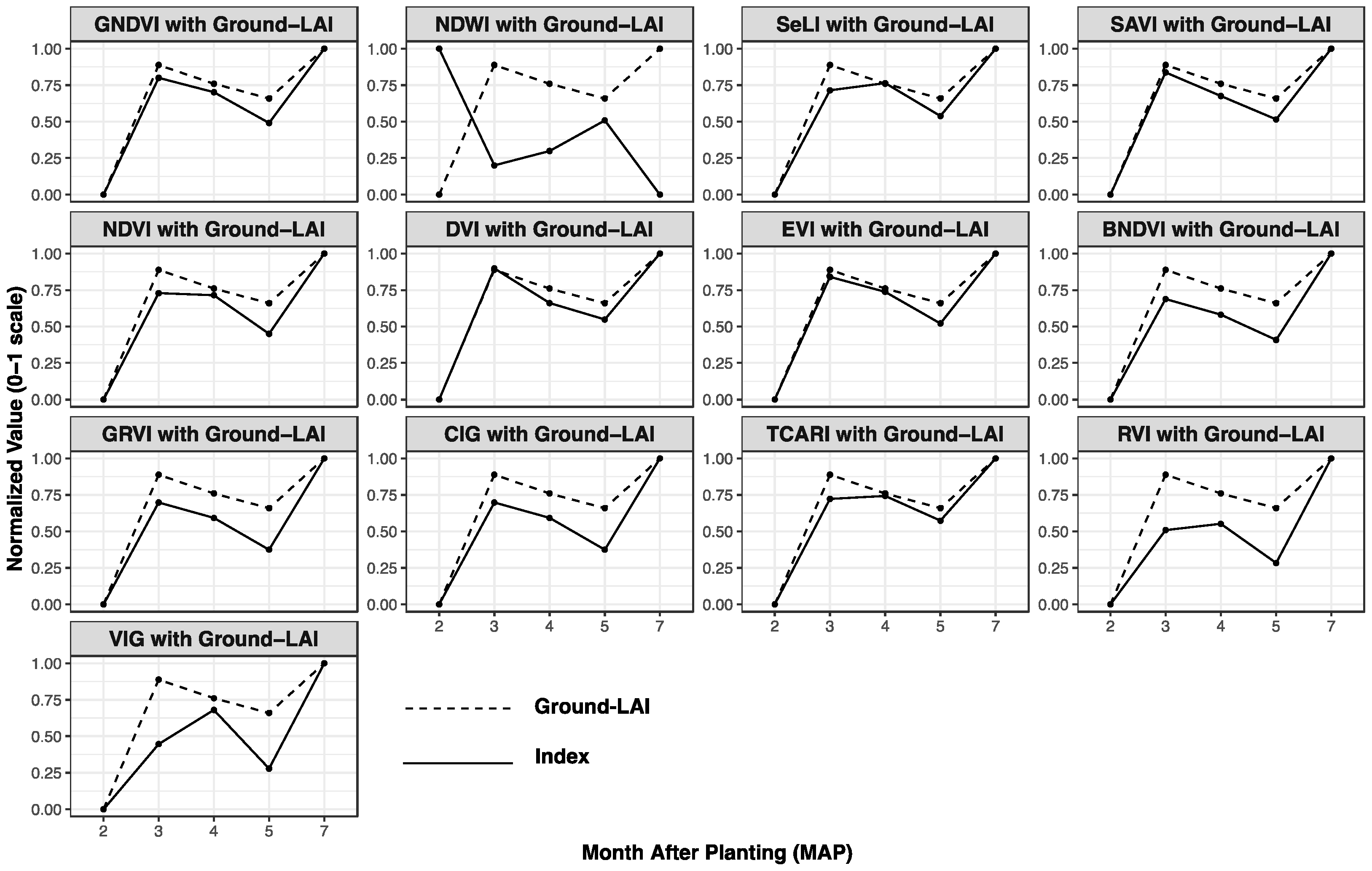
4.1. Consistency of Ground-LAI and Vegetation Indices
4.2. Predictive Performance of Vegetation Indices
4.2.1. Overall Performance (All Growth Stages)
4.2.2. Stage-Specific Performance
4.3. Impact of Spatial Heterogeneity on VI Performance
5. Conclusions
Supplementary Materials
Author Contributions
Funding
Data Availability Statement
Acknowledgments
Conflicts of Interest
Abbreviations
| LAI | Leaf Area Index |
| VIs | Vegetation Indices |
| RMSE | Root Mean Squared Error |
| CV | Coefficients of Variation |
| 95% CI | 95% of Confidence Interval |
| GEE | Google Earth Engine |
| MAP | Month After Planting |
| R | Red band |
| B | Blue band |
| G | Green band |
| RE1 | Red Edge 1 |
| RE2 | Red Edge 1SW |
| SWIR | Short-wave Infrared |
| NDVI | Normalized Difference Vegetation Index |
| SAVI | Soil-Adjusted Vegetation Index |
| EVI | Enhanced Vegetation Index |
| BNDVI | Blue Normalized Difference Vegetation Index |
| CIG | Chlorophyll Index Green |
| DVI | Difference Vegetation Index |
| GNDVI | Green Normalized Difference Vegetation Index |
| GRVI | Green Ratio Vegetation Index |
| NDWI | Normalized Difference Water Index |
| RVI | Ratio Vegetation Index |
| SeLI | Sentinel-2 LAI Green Index |
| TCARI | Transformed Chlorophyll Absorption in Reflectance Index |
| VIG | Vegetation Index Green |
References
- FAO. FAOSTAT Statistical Database; FAO: Rome, Italy, 2020. [Google Scholar]
- Lebot, V. Tropical Root and Tuber Crops: Cassava, Sweet Potato, Yams and Aroids; CABl: Hong Kong, 2020. [Google Scholar]
- OAE. Cassava: Planting Area, the Number of Smallholders, and the Average Planting Area per Smallholder—The Province Level in 2020; OAE: Bangkok, Thailand, 2020. [Google Scholar]
- Liu, F.; Song, Q.; Zhao, J.; Mao, L.; Bu, H.; Hu, Y.; Zhu, X.G. Canopy occupation volume as an indicator of canopy photosynthetic capacity. New Phytol. 2021, 232, 941–956. [Google Scholar] [CrossRef] [Scilit] [PubMed]
- Hoek van Dijke, A.J.; Mallick, K.; Schlerf, M.; Machwitz, M.; Herold, M.; Teuling, A.J. Examining the link between vegetation leaf area and land–atmosphere exchange of water, energy, and carbon fluxes using FLUXNET data. Biogeosciences 2020, 17, 4443–4457. [Google Scholar] [CrossRef] [Scilit]
- Pipatsitee, P.; Eiumnoh, A.; Praseartkul, P.; Ponganan, N.; Taota, K.; Kongpugdee, S.; Sakulleerungroj, K.; Cha-um, S. Non-Destructive Leaf Area Estimation Model for Overall Growth Performances in Relation to Yield Attributes of Cassava (Manihot esculenta Cranz) under Water Deficit Conditions. Not. Bot. Horti Agrobot. Cluj-Napoca 2019, 47, 580–591. [Google Scholar] [CrossRef] [Scilit]
- Mulla, D.J. Twenty five years of remote sensing in precision agriculture: Key advances and remaining knowledge gaps. Biosyst. Eng. 2013, 114, 358–371. [Google Scholar] [CrossRef] [Scilit]
- Sun, Y.; Qin, Q.; Ren, H.; Zhang, T.; Chen, S. Red-Edge Band Vegetation Indices for Leaf Area Index Estimation From Sentinel-2/MSI Imagery. IEEE Trans. Geosci. Remote Sens. 2020, 58, 826–840. [Google Scholar] [CrossRef] [Scilit]
- Viña, A.; Gitelson, A.A.; Nguy-Robertson, A.L.; Peng, Y. Comparison of different vegetation indices for the remote assessment of green leaf area index of crops. Remote Sens. Environ. 2011, 115, 3468–3478. [Google Scholar] [CrossRef] [Scilit]
- Dong, T.; Liu, J.; Shang, J.; Qian, B.; Ma, B.; Kovacs, J.M.; Walters, D.; Jiao, X.; Geng, X.; Shi, Y. Assessment of red-edge vegetation indices for crop leaf area index estimation. Remote Sens. Environ. 2019, 222, 133–143. [Google Scholar] [CrossRef] [Scilit]
- Serrano Reyes, J.; Jiménez, J.U.; Quirós-McIntire, E.I.; Sanchez-Galan, J.E.; Fábrega, J.R. Comparing Two Methods of Leaf Area Index Estimation for Rice (Oryza sativa L.) Using In-Field Spectroradiometric Measurements and Multispectral Satellite Images. AgriEngineering 2023, 5, 965–981. [Google Scholar] [CrossRef] [Scilit]
- Delegido, J.; Verrelst, J.; Alonso, L.; Moreno, J. Evaluation of Sentinel-2 Red-Edge Bands for Empirical Estimation of Green LAI and Chlorophyll Content. Sensors 2011, 11, 7063–7081. [Google Scholar] [CrossRef] [Scilit]
- Zou, X.; Zhu, S.; Mõttus, M. Estimation of Canopy Structure of Field Crops Using Sentinel-2 Bands with Vegetation Indices and Machine Learning Algorithms. Remote Sens. 2022, 14, 2849. [Google Scholar] [CrossRef] [Scilit]
- Montero, D.; Aybar, C.; Mahecha, M.D.; Wieneke, S. Spectral: Awesome Spectral Indices deployed via the Google Earth Engine JavaScript API. Int. Arch. Photogramm. Remote Sens. Spat. Inf. Sci. 2022, 48, 301–306. [Google Scholar] [CrossRef] [Scilit]
- Rouse, J.W.; Haas, R.H.; Schell, J.A.; Deering, D.W. Monitoring Vegetation Systems in the Great Plains with ERTS; NASA: Washington, DC, USA, 1974. [Google Scholar]
- Pasqualotto, N.; Bolognesi, S.F.; Belfiore, O.R.; Delegido, J.; D’Urso, G.; Moreno, J. Canopy chlorophyll content and LAI estimation from Sentine1-2: Vegetation indices and Sentine1-2 Leve1-2A automatic products comparison. In Proceedings of the 2019 IEEE International Workshop on Metrology for Agriculture and Forestry (MetroAgriFor), Naples, Italy, 24–26 October 2019; pp. 301–306. [Google Scholar]
- Kang, Y.; Özdoğan, M.; Zipper, S.; Román, M.; Walker, J.; Hong, S.; Marshall, M.; Magliulo, V.; Moreno, J.; Alonso, L.; et al. How Universal Is the Relationship between Remotely Sensed Vegetation Indices and Crop Leaf Area Index? A Global Assessment. Remote Sens. 2016, 8, 597. [Google Scholar] [CrossRef] [Scilit]
- Li, W.; Li, D.; Liu, S.; Baret, F.; Ma, Z.; He, C.; Warner, T.A.; Guo, C.; Cheng, T.; Zhu, Y.; et al. RSARE: A physically-based vegetation index for estimating wheat green LAI to mitigate the impact of leaf chlorophyll content and residue-soil background. ISPRS J. Photogramm. Remote Sens. 2023, 200, 138–152. [Google Scholar] [CrossRef] [Scilit]
- Selvaraj, M.G.; Valderrama, M.; Guzman, D.; Valencia, M.; Ruiz, H.; Acharjee, A.; Acharjee, A.; Acharjee, A. Machine learning for high-throughput field phenotyping and image processing provides insight into the association of above and below-ground traits in cassava (Manihot esculenta Crantz). Plant Methods 2020, 16, 87. [Google Scholar] [CrossRef] [Scilit]
- LDD. Soil Series of Bua Yai Distinct, Nakhon Ratchasima Province; Land Development Department (LDD): Bangkok, Thailand, 2018. [Google Scholar]
- CPC. El Niño/Southern Oscillation (ENSO) Diagnostic Discussion-13 January 2022; Climate Prediction Center: College Park, MD, USA, 2022. [Google Scholar]
- TMD. El Niño/La Niña Phenomenon Monitoring; TMD: Bangkok, Thailand, 2022; pp. 1–3. [Google Scholar]
- Oguntunde, P.G.; Olukunle, O.J.; Fasinmirin, J.T.; Abiolu, O.A. Performance of the SunScan canopy analysis system in estimating leaf area index of maize. Agric. Eng. Int. CIGR J. 2012, 14, 1–7. [Google Scholar]
- Wood, J. SunData Software and Canopy Theory; John Wood of Peak Design Ltd.: Derbyshire, UK, 1996. [Google Scholar]
- Campbell, G.S. Extinction coefficients for radiation in plant canopies calculated using an ellipsoidal inclination angle distribution. Agric. For. Meteorol. 1986, 36, 317–321. [Google Scholar] [CrossRef] [Scilit]
- Webb, N.; Nicholl, C.; Wood, J. User Manual for the SunScan Canopy Analysis System Type SS1, Version 3.3 ed.; Delta-T Devices: Cambridge, UK, 2016. [Google Scholar]
- Gorelick, N.; Hancher, M.; Dixon, M.; Ilyushchenko, S.; Thau, D.; Moore, R. Google Earth Engine: Planetary-scale geospatial analysis for everyone. Remote Sens. Environ. 2017, 202, 18–27. [Google Scholar] [CrossRef] [Scilit]
- Google Earth, E. Harmonized Sentinel-2 MSI: MultiSpectral Instrument, Level-2A (SR); Earth Engine Data Catalog; ESA: Paris, France, 2023. [Google Scholar]
- Main-Knorn, M.; Pflug, B.; Louis, J.; Debaecker, V.; Müller-Wilm, U.; Gascon, F. Sen2Cor for Sentinel-2. In Proceedings of the Image and Signal Processing for Remote Sensing XXIII, Warsaw, Poland, 11–14 September 2017; p. 3. [Google Scholar]
- Roujean, J.-L.; Breon, F.-M. Estimating PAR absorbed by vegetation from bidirectional reflectance measurements. Remote Sens. Environ. 1995, 51, 375–384. [Google Scholar] [CrossRef] [Scilit]
- Gitelson, A.A.; Kaufman, Y.J.; Merzlyak, M.N. Use of a green channel in remote sensing of global vegetation from EOS-MODIS. Remote Sens. Environ. 1996, 58, 289–298. [Google Scholar] [CrossRef] [Scilit]
- Sripada, R.P.; Heiniger, R.W.; White, J.G.; Weisz, R. Aerial Color Infrared Photography for Determining Late-Season Nitrogen Requirements in Corn. Agron. J. 2005, 97, 1443–1451. [Google Scholar] [CrossRef] [Scilit]
- Huete, A.R. A soil-adjusted vegetation index (SAVI). Remote Sens. Environ. 1988, 25, 295–309. [Google Scholar] [CrossRef] [Scilit]
- Huete, A.R.; Liu, H.Q.; Batchily, K.; van Leeuwan, W. A comparison of vegetation indices over a global set of TM images for EOS-MODIS. Remote Sens. Environ. 1997, 59, 440–451. [Google Scholar] [CrossRef] [Scilit]
- Gitelson, A.A.; Gritz, Y.; Merzlyak, M.N. Relationships between leaf chlorophyll content and spectral reflectance and algorithms for non-destructive chlorophyll assessment in higher plant leaves. J. Plant Physiol. 2003, 160, 271–282. [Google Scholar] [CrossRef] [Scilit]
- Haboudane, D.; Miller, J.R.; Tremblay, N.; Zarco-Tejada, P.J.; Dextraze, L. Integrated narrow-band vegetation indices for prediction of crop chlorophyll content for application to precision agriculture. Remote Sens. Environ. 2002, 81, 416–426. [Google Scholar] [CrossRef] [Scilit]
- Wang, F.-m.; Huang, J.-f.; Tang, Y.-l.; Wang, X.-z. New Vegetation Index and Its Application in Estimating Leaf Area Index of Rice. Rice Sci. 2007, 14, 195–203. [Google Scholar] [CrossRef] [Scilit]
- Gitelson, A.A.; Kaufman, Y.J.; Stark, R.; Rundquist, D. Novel algorithms for remote estimation of vegetation fraction. Remote Sens. Environ. 2002, 80, 76–87. [Google Scholar] [CrossRef] [Scilit]
- McFeeters, S.K. The use of the Normalized Difference Water Index (NDWI) in the delineation of open water features. Int. J. Remote Sens. 1996, 17, 1425–1432. [Google Scholar] [CrossRef] [Scilit]
- Pasqualotto, N.; Delegido, J.; Van Wittenberghe, S.; Rinaldi, M.; Moreno, J. Multi-Crop Green LAI Estimation with a New Simple Sentinel-2 LAI Index (SeLI). Sensors 2019, 19, 904. [Google Scholar] [CrossRef] [Scilit]
- Birth, G.S.; McVey, G.R. Measuring the Color of Growing Turf with a Reflectance Spectrophotometer. Agron. J. 1968, 60, 640–643. [Google Scholar] [CrossRef] [Scilit]
- Hijmans, R.J. terra: Spatial Data Analysis. 2024. Available online: https://cran.r-project.org/web/packages/terra/index.html (accessed on 9 November 2025).
- Kuznetsova, A.; Brockhoff, P.B.; Christensen, R.H.B. lmerTest Package: Tests in Linear Mixed Effects Models. J. Stat. Softw. 2017, 82, 1–26. [Google Scholar] [CrossRef] [Scilit]
- R Core Team. R: A Language and Environment for Statistical Computing; R Core Team: Vienna, Austria, 2024. [Google Scholar]
- Chai, T.; Draxler, R.R. Root mean square error (RMSE) or mean absolute error (MAE)?—Arguments against avoiding RMSE in the literature. Geosci. Model Dev. 2014, 7, 1247–1250. [Google Scholar] [CrossRef] [Scilit]
- Hodson, T.O. Root-mean-square error (RMSE) or mean absolute error (MAE): When to use them or not. Geosci. Model Dev. 2022, 15, 5481–5487. [Google Scholar] [CrossRef] [Scilit]
- Nakagawa, S.; Schielzeth, H. A general and simple method for obtaining R2 from generalized linear mixed-effects models. Methods Ecol. Evol. 2013, 4, 133–142. [Google Scholar] [CrossRef] [Scilit]
- Phosaengsri, W.; Banterng, P.; Vorasoot, N.; Jogloy, S.; Theerakulpisut, P. Leaf Performances of cassava genotypes in different seasons and its relationship with biomass. Turk. J. Field Crops 2019, 24, 54–64. [Google Scholar] [CrossRef] [Scilit]
- Din, M.; Zheng, W.; Rashid, M.; Wang, S.; Shi, Z. Evaluating Hyperspectral Vegetation Indices for Leaf Area Index Estimation of Oryza sativa L. at Diverse Phenological Stages. Front. Plant Sci. 2017, 8, 820. [Google Scholar] [CrossRef] [Scilit] [PubMed]
- Xie, Q.; Dash, J.; Huang, W.; Peng, D.; Qin, Q.; Mortimer, H.; Casa, R.; Pignatti, S.; Laneve, G.; Pascucci, S.; et al. Vegetation Indices Combining the Red and Red-Edge Spectral Information for Leaf Area Index Retrieval. IEEE J. Sel. Top. Appl. Earth Obs. Remote Sens. 2018, 11, 1482–1493. [Google Scholar] [CrossRef] [Scilit]
- Lykhovyd, P. Sweet Corn Yield Simulation Using Normalized Difference Vegetation Index and Leaf Area Index. J. Ecol. Eng. 2020, 21, 228–236. [Google Scholar] [CrossRef] [Scilit] [PubMed]
- Bajocco, S.; Ginaldi, F.; Savian, F.; Morelli, D.; Scaglione, M.; Fanchini, D.; Raparelli, E.; Bregaglio, S.U.M. On the Use of NDVI to Estimate LAI in Field Crops: Implementing a Conversion Equation Library. Remote Sens. 2022, 14, 3554. [Google Scholar] [CrossRef] [Scilit]
- Han, J.; Song, X.; Zhou, Z.; Chen, Y.; Wei, C.; Liu, W.; Huang, J.; Song, P.; Zhang, D.; Han, B. Estimating leaf area index of winter oilseed rape using high spatial resolution satellite data. In Proceedings of the 2016 Fifth International Conference on Agro-Geoinformatics (Agro-Geoinformatics), Tianjin, China, 18–20 July 2016; pp. 1–5. [Google Scholar]
- Zou, X.; Haikarainen, I.; Haikarainen, I.P.; Mäkelä, P.; Mõttus, M.; Pellikka, P. Effects of Crop Leaf Angle on LAI-Sensitive Narrow-Band Vegetation Indices Derived from Imaging Spectroscopy. Appl. Sci. 2018, 8, 1435. [Google Scholar] [CrossRef] [Scilit]
- Qiao, K.; Zhu, W.; Xie, Z.; Li, P. Estimating the Seasonal Dynamics of the Leaf Area Index Using Piecewise LAI-VI Relationships Based on Phenophases. Remote Sens. 2019, 11, 689. [Google Scholar] [CrossRef] [Scilit]
- Towers, P.C.; Strever, A.; Poblete-Echeverría, C. Comparison of Vegetation Indices for Leaf Area Index Estimation in Vertical Shoot Positioned Vine Canopies with and without Grenbiule Hail-Protection Netting. Remote Sens. 2019, 11, 1073. [Google Scholar] [CrossRef] [Scilit]
- Gao, B.-c. NDWI—A normalized difference water index for remote sensing of vegetation liquid water from space. Remote Sens. Environ. 1996, 58, 257–266. [Google Scholar] [CrossRef] [Scilit]
- Sims, D.A.; Gamon, J.A. Estimation of vegetation water content and photosynthetic tissue area from spectral reflectance: A comparison of indices based on liquid water and chlorophyll absorption features. Remote Sens. Environ. 2003, 84, 526–537. [Google Scholar] [CrossRef] [Scilit]
- Gitelson, A.A. Wide Dynamic Range Vegetation Index for Remote Quantification of Biophysical Characteristics of Vegetation. J. Plant Physiol. 2004, 161, 165–173. [Google Scholar] [CrossRef] [Scilit] [PubMed]
- Jingguo, T.; Shudong, W.; Lifu, Z.; Taixia, W.; Xiaojun, S.; Hailing, J. Evaluating different vegetation index for estimating lai of winter wheat using hyperspectral remote sensing data. In Proceedings of the 2015 7th Workshop on Hyperspectral Image and Signal Processing: Evolution in Remote Sensing (WHISPERS), Tokyo, Japan, 2–5 June 2015; pp. 1–4. [Google Scholar]
- Delegido, J.; Verrelst, J.; Meza, C.M.; Rivera, J.P.; Alonso, L.; Moreno, J. A red-edge spectral index for remote sensing estimation of green LAI over agroecosystems. Eur. J. Agron. 2013, 46, 42–52. [Google Scholar] [CrossRef] [Scilit]
- Xing, N.; Huang, W.; Ye, H.; Dong, Y.; Kong, W.; Ren, Y.; Xie, Q. Remote sensing retrieval of winter wheat leaf area index and canopy chlorophyll density at different growth stages. Big Earth Data 2022, 6, 580–602. [Google Scholar] [CrossRef] [Scilit]
- Zhao, J.; Zhong, Y.; Hu, X.; Wei, L.; Zhang, L. A robust spectral-spatial approach to identifying heterogeneous crops using remote sensing imagery with high spectral and spatial resolutions. Remote Sens. Environ. 2020, 239, 111605. [Google Scholar] [CrossRef] [Scilit]
- Aduvukha, G.R.; Abdel-Rahman, E.M.; Sichangi, A.W.; Makokha, G.O.; Landmann, T.; Mudereri, B.T.; Tonnang, H.E.Z.; Dubois, T. Cropping Pattern Mapping in an Agro-Natural Heterogeneous Landscape Using Sentinel-2 and Sentinel-1 Satellite Datasets. Agriculture 2021, 11, 530. [Google Scholar] [CrossRef] [Scilit]
- Skakun, S.; Kalecinski, N.I.; Brown, M.G.L.; Johnson, D.M.; Vermote, E.F.; Roger, J.-C.; Franch, B. Assessing within-Field Corn and Soybean Yield Variability from WorldView-3, Planet, Sentinel-2, and Landsat 8 Satellite Imagery. Remote Sens. 2021, 13, 872. [Google Scholar] [CrossRef] [Scilit]
- Ding, Y.; Zhao, K.; Zheng, X.; Jiang, T. Temporal dynamics of spatial heterogeneity over cropland quantified by time-series NDVI, near infrared and red reflectance of Landsat 8 OLI imagery. Int. J. Appl. Earth Obs. Geoinf. 2014, 30, 139–145. [Google Scholar] [CrossRef] [Scilit]
- Zhang, D.; Hou, L.; Lv, L.; Qi, H.; Sun, H.; Zhang, X.; Li, S.; Min, J.; Liu, Y.; Tang, Y.; et al. Precision Agriculture: Temporal and Spatial Modeling of Wheat Canopy Spectral Characteristics. Agriculture 2025, 15, 326. [Google Scholar] [CrossRef] [Scilit]
- Houborg, R.; McCabe, M.F. Impacts of dust aerosol and adjacency effects on the accuracy of Landsat 8 and RapidEye surface reflectances. Remote Sens. Environ. 2017, 194, 127–145. [Google Scholar] [CrossRef] [Scilit]
- Choi, W.; Ryu, Y.; Kong, J.; Jeong, S.; Lee, K. Evaluation of spatial and temporal variability in Sentinel-2 surface reflectance on a rice paddy landscape. Agric. For. Meteorol. 2025, 363, 110401. [Google Scholar] [CrossRef] [Scilit]
- Burchard-Levine, V.; Nieto, H.; Riaño, D.; Migliavacca, M.; El-Madany, T.S.; Guzinski, R.; Carrara, A.; Martín, M.P. The effect of pixel heterogeneity for remote sensing based retrievals of evapotranspiration in a semi-arid tree-grass ecosystem. Remote Sens. Environ. 2021, 260, 112440. [Google Scholar] [CrossRef] [Scilit]
- Rossi, C.; McMillan, N.A.; Schweizer, J.M.; Gholizadeh, H.; Groen, M.; Ioannidis, N.; Hauser, L.T. Parcel level temporal variance of remotely sensed spectral reflectance predicts plant diversity. Environ. Res. Lett. 2024, 19, 074023. [Google Scholar] [CrossRef] [Scilit]
- Park, S.; Park, N.-W.; Na, S.-i. An Object-Based Weighting Approach to Spatiotemporal Fusion of High Spatial Resolution Satellite Images for Small-Scale Cropland Monitoring. Agronomy 2022, 12, 2572. [Google Scholar] [CrossRef] [Scilit]




| MAP | LAI Measurement Date | Sentinel-2 Data Retrieval Date |
|---|---|---|
| 2 | 17–18 January | 16 January |
| 3 | 23–24 February | 25 February |
| 4 | 19–20 March | 27 March |
| 5 | 21–22 April | 26 April |
| 7 | 25–26 June | 20 June |
| Index | Name | Formular | Variable (Band) | Reference |
|---|---|---|---|---|
| NDVI | Normalized Difference Vegetation Index | (N − R)/(N + R) | N (B8; 835.1 nm), R (B4; 664.5 nm) | [15] |
| SAVI | Soil-Adjusted Vegetation Index | (1 + L) × (N − R)/(N + R + L) | N (B8; 835.1 nm), R (B4; 664.5 nm) | [33] |
| EVI | Enhanced Vegetation Index | g × (N − R)/[(N + C1) × (R − C2) × (B + L)] | N (B8; 835.1 nm), R (B4; 664.5 nm), B (B2; 496.6 nm) | [34] |
| BNDVI | Blue Normalized Difference Vegetation Index | (N − B)/(N + B) | N (B8; 835.1 nm), B (B2; 496.6 nm), | [37] |
| CIG | Chlorophyll Index Green | (N/G) − 1.0 | N (B8; 835.1 nm), G (B3; 560.0 nm) | [35] |
| DVI | Difference Vegetation Index | N − R | N (B8; 835.1 nm), R (B4; 664.5 nm) | [30] |
| GNDVI | Green Normalized Difference Vegetation Index | (N − G)/(N + G) | N (B8; 835.1 nm), G (B3; 560.0 nm) | [31] |
| GRVI | Green Ratio Vegetation Index | N/G | N (B8; 835.1 nm), G (B3; 560.0 nm) | [32] |
| NDWI | Normalized Difference Water Index | (G − N)/(G + N) | N (B8; 835.1 nm), G (B3; 560.0 nm) | [39] |
| RVI | Ratio Vegetation Index | RE2/R | R (B4; 664.5 nm), RE2 (B6; 740 nm) | [41] |
| SeLI | Sentinel-2 LAI Green Index | (N2 − RE1)/(N2 + RE1) | RE1 (B5; 704 nm), N2 (B8A; 864.8 nm) | [40] |
| TCARI | Transformed Chlorophyll Absorption in Reflectance Index | 3 × ((RE1 − R) − 0.2 × (RE1 − G) × (RE1/R)) | G (B3; 560.0 nm), R (B4; 664.5 nm), RE1 (B5; 703.9 nm) | [36] |
| VIG | Vegetation Index Green | (G − R)/(G + R) | G (B3; 560.0 nm), R (B4; 664.5 nm) | [38] |
| Index | Without Tree (N = 19) | Bootstrapping-Derived with-Tree (N = 19) | |||||
|---|---|---|---|---|---|---|---|
| RMSE | Mean RMSE | Median RMSE | SD RMSE | Lower CI RMSE | Upper CI RMSE | CV RMSE | |
| GNDVI 3 | 0.370 | 0.340 | 0.343 | 0.024 | 0.286 | 0.380 | 0.071 |
| NDWI 3 | 0.370 | 0.340 | 0.343 | 0.024 | 0.286 | 0.380 | 0.071 |
| SAVI | 0.378 | 0.349 | 0.352 | 0.025 | 0.292 | 0.391 | 0.073 |
| DVI | 0.383 | 0.349 | 0.353 | 0.025 | 0.293 | 0.390 | 0.073 |
| BNDVI | 0.380 | 0.354 | 0.356 | 0.024 | 0.304 | 0.396 | 0.069 |
| EVI | 0.377 | 0.354 | 0.356 | 0.026 | 0.294 | 0.398 | 0.074 |
| NDVI | 0.372 | 0.356 | 0.358 | 0.026 | 0.301 | 0.400 | 0.073 |
| SeLI 1 | 0.361 | 0.358 | 0.361 | 0.028 | 0.294 | 0.406 | 0.077 |
| GRVI 3 | 0.370 | 0.361 | 0.362 | 0.024 | 0.310 | 0.402 | 0.067 |
| CIG 2 | 0.367 | 0.361 | 0.362 | 0.024 | 0.310 | 0.402 | 0.067 |
| TCARI | 0.411 | 0.376 | 0.381 | 0.031 | 0.312 | 0.422 | 0.082 |
| RVI | 0.385 | 0.409 | 0.411 | 0.028 | 0.356 | 0.454 | 0.068 |
| VIG | 0.433 | 0.425 | 0.428 | 0.029 | 0.364 | 0.473 | 0.068 |
Disclaimer/Publisher’s Note: The statements, opinions and data contained in all publications are solely those of the individual author(s) and contributor(s) and not of MDPI and/or the editor(s). MDPI and/or the editor(s) disclaim responsibility for any injury to people or property resulting from any ideas, methods, instructions or products referred to in the content. |
© 2026 by the authors. Licensee MDPI, Basel, Switzerland. This article is an open access article distributed under the terms and conditions of the Creative Commons Attribution (CC BY) license.
Share and Cite
Promnikorn, K.; Jenkit, T.; Kittipadakul, P.; Kraichak, E. Evaluation of Sentinel-2 Vegetation Indices for Estimating Leaf Area Index in Cassava Plots. AgriEngineering 2026, 8, 134. https://doi.org/10.3390/agriengineering8040134
Promnikorn K, Jenkit T, Kittipadakul P, Kraichak E. Evaluation of Sentinel-2 Vegetation Indices for Estimating Leaf Area Index in Cassava Plots. AgriEngineering. 2026; 8(4):134. https://doi.org/10.3390/agriengineering8040134
Chicago/Turabian StylePromnikorn, Kanokporn, Thanpitcha Jenkit, Piya Kittipadakul, and Ekaphan Kraichak. 2026. "Evaluation of Sentinel-2 Vegetation Indices for Estimating Leaf Area Index in Cassava Plots" AgriEngineering 8, no. 4: 134. https://doi.org/10.3390/agriengineering8040134
APA StylePromnikorn, K., Jenkit, T., Kittipadakul, P., & Kraichak, E. (2026). Evaluation of Sentinel-2 Vegetation Indices for Estimating Leaf Area Index in Cassava Plots. AgriEngineering, 8(4), 134. https://doi.org/10.3390/agriengineering8040134