Article

Surveying a Sacred Landscape: First Steps to a Holistic Documentation of Buddhist Architecture in Dolpo

by
Carmen Elisabeth Auer
Institute of Architectural Theory, History of Art and Cultural Studies, Faculty of Architecture, Graz University of Technology, 8010 Graz, Austria
Heritage 2025, 8(9), 385; https://doi.org/10.3390/heritage8090385
Submission received: 11 August 2025 / Revised: 9 September 2025 / Accepted: 11 September 2025 / Published: 17 September 2025
(This article belongs to the Topic 3D Documentation of Natural and Cultural Heritage)

Abstract

Dolpo is a culturally Tibetan region in the inaccessible parts of the Himalayas, where Buddhist and Bon traditions coexist to this day. Due to their religious significance, the temples and monasteries of Dolpo reflect the historical connection to the religious centres of the Tibetan area. Accordingly, a holistic documentation of the preserved buildings can provide new insights for the development of typologies of Buddhist architecture in the Western Himalayas. To shed light on the mainly undocumented Buddhist architecture of this region, we launched our first research project in 2018. As a result, the architectural documentation of eighteen Buddhist sites in Dolpo is now available for the first time, based on the on-site assessment and survey during four field missions between 2018 and 2023. It provides an overview of the location, descriptions and references, photographs, sets of plans and 3D models of the surveyed buildings, enabling an inventory of the region’s cultural heritage to be initiated. The results enable us to establish a comprehensive typology of Buddhist architecture in Dolpo that allows for comparative analyses with buildings already documented in previous projects. Last but not least, the documentation provides the basis for much-needed restoration work.

1. Introduction

In recent years, we have been able to secure important documentation and materials on sacred buildings in Dolpo, Western Nepal, as part of our research on Buddhist architecture in the Western Himalayas at the Graz University of Technology. Between 2018 and 2025, two projects funded by the Austrian Science Fund (FWF) allowed us to lay the foundations for architectural research in the region. Comprehensive architectural documentation has been collected in a relatively short time, providing a basis for further research. From a building research perspective, the focus is on the analysis and presentation of the structures in order to gain new insights into special architectural features. And, of course, to promote and support the preservation of the buildings in the long term.
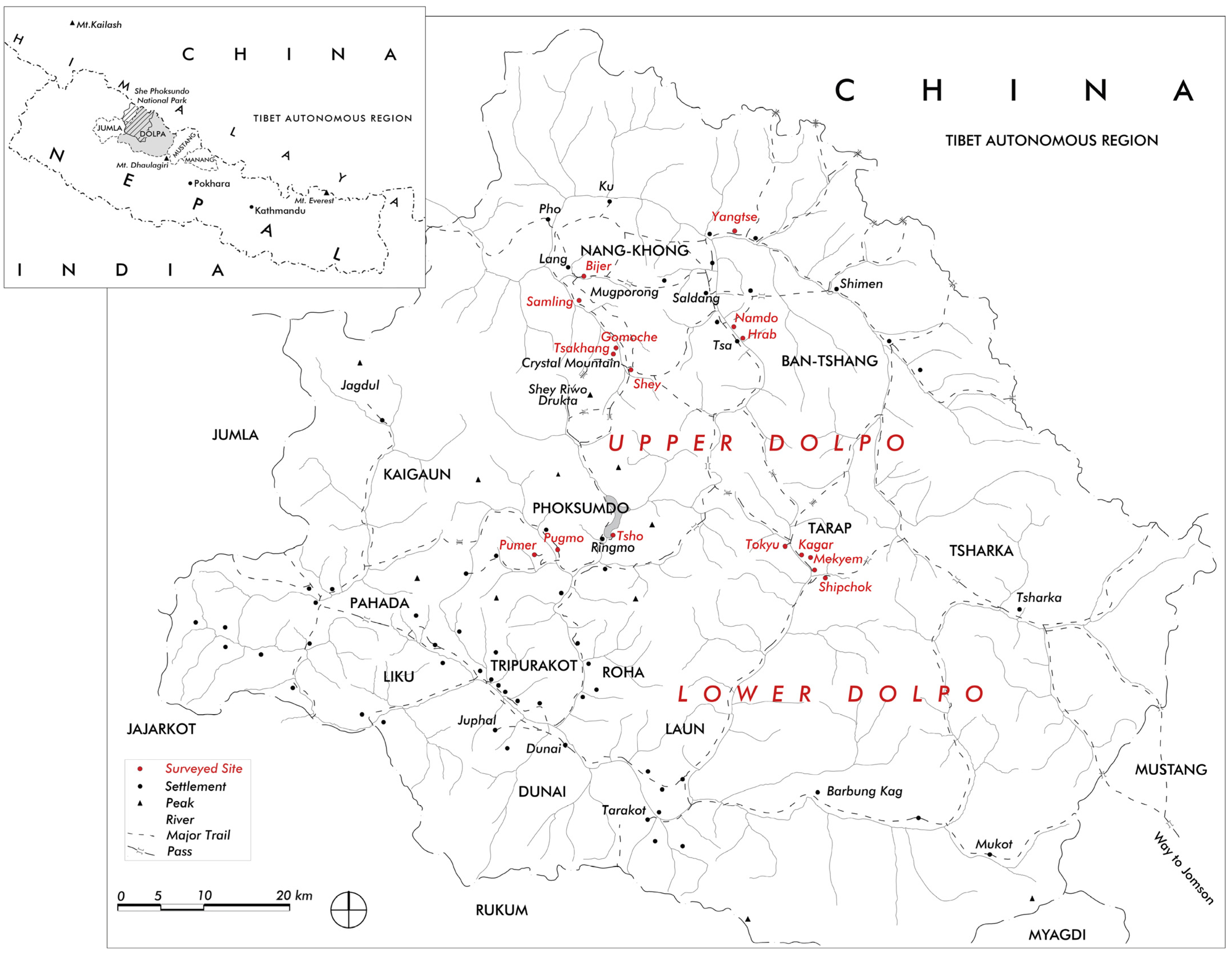
Upper Dolpo is still a remote area. The region is one of the last hidden lands in the inaccessible parts of the Western Himalayas, where Buddhist and Bon traditions were spared from both the Chinese and the Nepalese central powers. Parts of this area were established as Nepal’s largest national park in 1984 (Shey-Phoksundo National Park), and an additional buffer zone was added in 1998. But the region is increasingly subject to change. In particular, one of Nepal’s priority projects for trans-Himalayan connectivity—the Kali Gandaki Corridor between India (Sunauli) and China (Kora La)—will bring significant infrastructural changes to the region and its culture. Parts of the new road will pass through Dolpo and Mustang. At the same time, local people are calling for the region to be removed from the list of restricted areas in order to boost tourism and improve local incomes (Figure 1).
In view of the expected changes, it is essential to carry out an architectural survey of the monuments in order to compile a representative documentation of the significant sacred buildings of this region that have developed over the centuries. On the one hand, we aim to use the collected data and research results to create a comprehensive typology of Buddhist architecture in the Western Himalayas. On the other hand, architectural research enriches the knowledge of other scientific disciplines, such as art history and Buddhist studies, and furthermore provides the basis for urgently needed renovations.

1.1. Short Historical Remarks on Dolpo

Dolpo is one of twelve enclaves of Tibetan-speaking groups along Nepal’s border with the Tibet Autonomous Region (China) in the north [1]. The Himalayas were the central axis along which Buddhism spread between the 7th and 12th centuries, along the upper branches of the Indus River to the arid regions of the Tibetan plateau, of which Dolpo is a remote valley. Coming from the west in Guge, Purang and Yatse, and going towards Lo Manthang and Gungthang, Buddhism reached Dolpo very early, being introduced by religious masters in the 11th century [2]. With the religious patronage of Khasa dynasty rulers in Jumla in the 12th century, both Buddhist and Bon practitioners set foot in Dolpo.
The toponym Dolpo was first mentioned in the 13th century as one of the thirteen administrating districts of Gungthang [3]. In local tradition, the name Dolpo was originally used for an area consisting of the four northern valleys of the region: Namgung (Nangk-hong), Panzang (Ban-tshang), Tarap and Tsharbung, which included Tsharka and Barbung [4] (p. 83). In the 15th century, Amepal established his kingdom in Lo (Mustang), thus bringing Dolpo under the jurisdiction of Lo. The influence of Lo had an immense impact on both Buddhist and Bon traditions in Dolpo at that time through a system of succession and patronage. When Lo and Dolpo fell under the power of the newly revived kingdom of Jumla in the 17th century, religious affiliations remained mainly with Lo [5]. In the 20th century, the district boundaries were redrawn, and Dolpo, along with the districts of Jumla, Mugu, Humla and Kalikot, became part of the Karnali zone. In contemporary practice, the Dolpa district is divided into Lower Dolpo and Upper Dolpo, which does not correspond to the former area designations. The valley of Tarap, once part of the core of traditional Dolpo, has thus become part of Lower Dolpo [6] (pp. 59–63) (Figure 2).

1.2. International Research on Dolpo

The first relatively reliable maps of the area were made by two surveyors, Jagdish Behari Lal and Lalbir Singh Thapa, on behalf of the Survey of India in 1925–1926 [4] (p. XV). After the opening of Nepal to tourism in 1951, Dolpo became accessible to foreign visitors, but it was closed again in 1974 due to conflicts along the Tibetan border—until its reopening in 1989. In 1952 and 1954, the Italian Tibetologist Giuseppe Tucci (1894–1984) passed through Dolpo as part of his travels through the Himalayas and provided the first insights into this remote region [7]. The British Tibetologist David Snellgrove (1920–2016) introduced Dolpo as an area of scientific research. His first visit to Dolpo took place between March and September 1956 during a trip to the remote north–western regions of Nepal. A detailed account of this journey, entitled Himalayan Pilgrimage, was published in 1961, with the longest chapter devoted to ‘The Land of Dolpo’ [4]. With the support of the School of Oriental and African Studies at the University of London, Snellgrove was able to make a second extended visit between October 1960 and May 1961, spending the winter in Dolpo together with the anthropologist Corneille Jest. David Snellgrove is also recognised as one of the main figures in Western scholarship on Bon, although he placed particular emphasis on the Buddhist heritage and communities through his journeys [8]. From 1961, Corneille Jest (1930–2019) was involved in various projects to preserve the cultural heritage of Nepal as a consultant to UNESCO [9]. In 1975, he published a detailed study of the region entitled Dolpo: Communautés de Langue Tibétaine du Nepal [1]. Snellgrove’s and Jest’s publications not only formed the basis for subsequent research in Dolpo but also provide detailed contemporary evidence of the social and structural change in the region.
Following generations of social anthropologists, such as Charles Ramble and Marietta Kind, and Tibetologists, such as Klaus-Dieter Mathes and Amy Heller, have continued to explore religious life and the symbolism, rituals and lineages in both the Buddhist and Bon traditions of Dolpo. Since 1992, expeditions by the Tibetan section of the Nepal-German Manuscript Preservation Project (NGMCP) have documented considerable Tibetan manuscripts from Dolpo [10]. In 2000, the hidden library of the Nesar temple of Bijer was made public, containing more than 600 volumes of manuscripts from the 11th to 16th centuries [11]. Subsequently, the ‘Tibetan Manuscript Project Vienna’ (TMPV) aims to trace unknown lines of textual transmission between Mustang, Dolpo and Ladakh, as well as Central Tibetan sources of this material [12]. While many multidisciplinary research projects have been carried out in the neighbouring regions of Dolpo in recent decades, especially in Mustang, sources on Buddhist architecture in Dolpo remained rare. In addition to the aforementioned publications by Snellgrove and Jest, only a limited number of publications–primarily focusing on the more accessible areas of Dolpo, such as Phoksundo and Tarap–offered insights into the architectural characteristics of regional temples and the structural characteristics of regional settlements [13,14,15,16]. To shed light on the mainly undocumented Buddhist architecture of this region, we launched our first research project in the spring of 2018.

2. Materials and Methods

Built structures are the most important and reliable source for the architectural research. In Dolpo they are predominantly the only sources available to us, as translations of written sources are rarely available and dating is difficult in this respect. The possibility of art-historian dating based on the interior decoration—i.e., inscription or preserved wall paintings—is also of little help, as the original decoration is often not preserved. Our strategy is therefore to comprehensively document the inventory in order to obtain material for a constructive and typological analyses of different sacred building types and their development. Therefore, once all the available information has been gathered, a successful field survey is a prerequisite for all subsequent stages of work.

2.1. Field Research

As a first step, we try to capture the various buildings in their entirety. Sketches, drawings and photographs of the most important parts are made, which then form the basis of later documentation strategies. Geographical and topographical features, such as the landscape, village structures and the surrounding structures of the sacred ensembles, are an essential part of the survey.
The second step of the process focuses on a detailed structural survey of the buildings. As part of our first research project on Dolpo (2018–2021), it was essential to compile an inventory of the preserved sacred buildings in the region. It was possible to establish contacts with local stakeholders, to obtain access to the buildings and obtain permission to survey them for first time. Based on the on-site assessment a first inventory includes thirteen ensembles of sacred buildings which form the basis for further analysis and processing. Five of these ensembles, the monastic complexes of Tsho/Ringmo (N° 01), Pugmo (N° 02), Pumer (N° 03), Shipchok (N° 18) and Tokyu (N° 12), were surveyed manually in 2019. Manual measurements were taken using tape measures, laser distance meters and measuring rods for better recording of heights.
In cooperation with the Institute of Engineering Geodesy and Measurement Systems (IGMS) at the Graz University of Technology, we were able to optimise the building documentation during the fieldwork in the frame of the second project (2022–2025) by using high-tech 3D surveying and achieve a geodetic level of accuracy in the survey [17,18]. The 3D laser scanner (Leica RTC 360, Leica Geosystems, Zurich, Switzerland) was combined with a manual total station (Leica TS11, Leica Geosystems, Zurich, Switzerland) for measuring reference coordinates in a locally created geodetic network. It allowed a fast and accurate high-resolution building survey (Figure 3). This could significantly reduce the time spent surveying on site. Despite the necessary reduction in power consumption, which also means a reduction in the functionality of the measuring system, these methods still met the requirements for architectural surveying, and their accuracy formed the basis of the subsequent architectural documentation. These procedures were complemented by manual measurements of building details and interiors that were not accessible to the instrument.
Compared to the first manual surveys in 2019, the quality and quantity of the data collected in 2022, increased significantly. The transport and functionality of the technical equipment was a challenge but nevertheless enabled a comprehensive digital building survey of the following four ensembles: Shey Sumdo Monastery (N° 04), Gomoche Gompa (N° 06), Nesar Gompa of Bijer (N° 07) and Samling Monastery (N° 08). At Tsho (N° 01) and Tokyu (N° 12), additional digital exterior measurements and photographs were taken to supplement the existing documentation. The following 2023 survey covered eight sites. Starting in the Tarap Valley, we documented the Ribo Bhumpa Gompa (N° 17), the Shipchok Monastery (N° 18), the ensemble of Mekyem (N° 16), the Kagar Village Gompa (N° 13), the remains of the nearby Trangmar Gompa (N° 14) and the Zur Gompa (N° 15) on the hill above. Further north, in the Nangkhong Valley, we surveyed the monastery of Hrab (N° 11) and the ensemble of Namdo (N° 10).
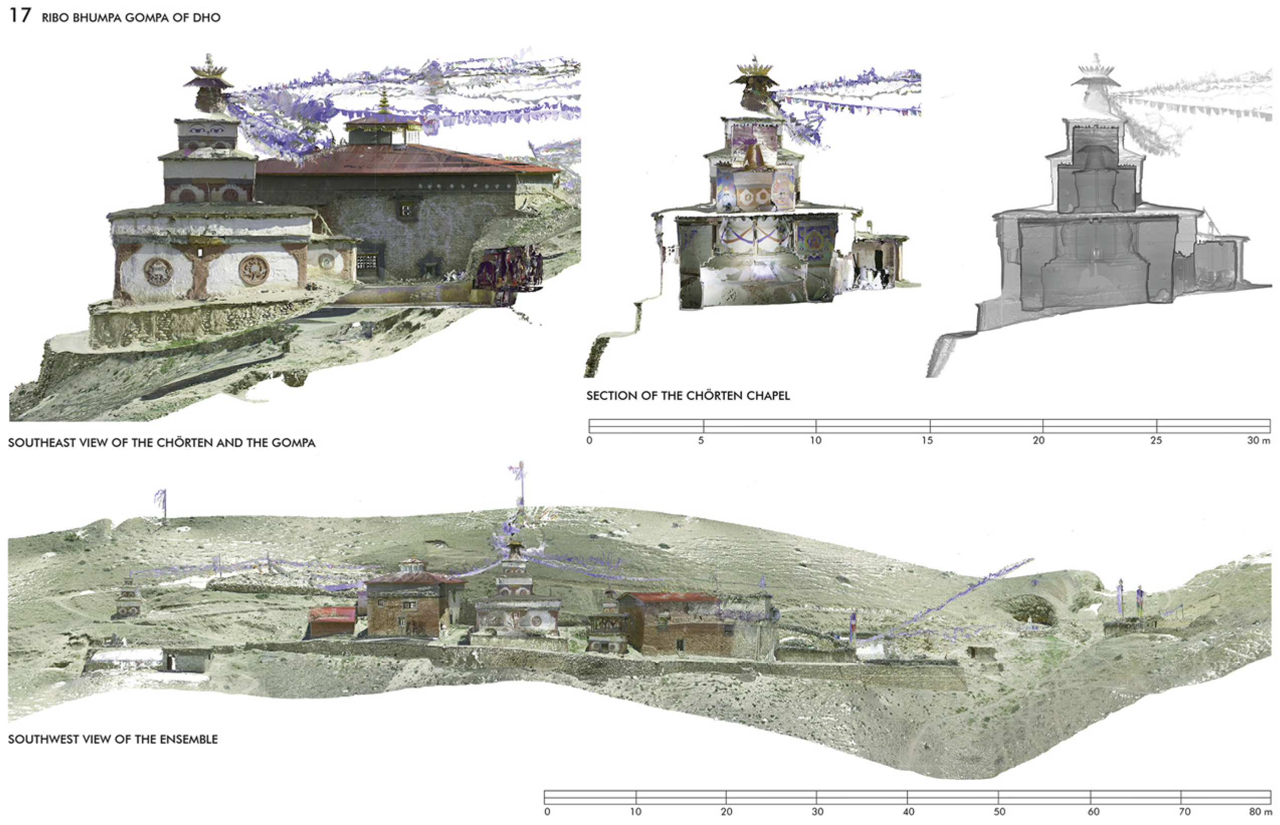
The third step of the process is the documentation of artistic and technical details and the interior decoration. The purpose of this step is twofold: firstly, to support interdisciplinary collaboration, and secondly, to illustrate the different themes that usually appear only fragmentarily in the context of the building as a whole. This enables us to place various features, such as inscriptions, sculptures, wall and ceiling paintings and wood carvings, in their overall context. Due to the lack of natural light and limited space in some temples, it is sometimes impossible to capture the interior artwork in its entirety. The technical use of a 3D scanner helped us to improve the documentation of the interior, as the laser scanner not only captures the geometry but also uses an integrated high-resolution camera that also captured all surfaces (Figure 4). The collection of metadata and data integrity checks in the field office completed each phase of fieldwork. Once the fieldwork was finished, the collected data needs to be evaluated, depicted and archived.

2.2. Plan Documentation and Analyses

The plan documentation put together the data that we collected during the field research and enables a detailed analysis of the building structures that can be comprehensively presented in the form of different representations. There are a number of commercially available drawing programmes with different specifications for the preparation of the plans. Depending on the requirements, we work with drawing programmes like AutoCAD 25 and ArchiCAD 25 for creating the 2D plans. Plug-ins facilitate the evaluation and further processing of 3-dimensional point clouds in these programmes. The Leica Cloud Worx plug-in is compatible with AutoCAD, while the Point Cap Origins plug-in is compatible with ArchiCAD. It is therefore possible to produce accurate analyses of the building structures on their actual scale.
These analyses can then be presented in a comprehensive plan documentation, including site plans, floor plans, longitudinal and cross-sections, elevations, ceiling plans and construction details. It allows us to represent the monuments with all their significant spatial characteristics such as orientation, function, size and construction. This documentation is fundamental to all further analysis and spatial representations and is essential for understanding the design process and planning history. Horizontal and vertical sections, for example, show the construction and their buildings’ static systems as well as the spatial concepts with the sequence of rooms, the different dimensions and storey heights and the lighting concepts. Different wall thicknesses or bricked-up rooms indicate different phases of construction and provide a basic understanding of the original concepts. In this way, the plan documentation allows us to determine the construction phases and structural changes. It also helps to assess the stability of the building structure and the state of its deformation. The structural problems of most temples and monasteries can largely be attributed to the fact that they were not built in a single construction phase. For example, subsequent expansion of the building through the addition of floors puts additional stress on the lower areas and often results in serious damage to the building. These findings are of fundamental importance for the development of various methods for the effective maintenance and restoration of the respective buildings.

Comparative Study

A holistic and comparative study of the research material will help us to answer the following questions. How are sites for sacred structures chosen? How are the buildings integrated into the natural environment? What aspects, such as function, construction technique and material, form, size, orientation and artistic equipment, can help us clarify a typology of the temples? Which buildings can we define as prototypes? Which religious texts provide building rules and how can these texts help us determine characteristics and typologies? Which building rules underline the proportional principles of geometry and spatial relationships? Is there any proportional concordance between the architecture of a temple and its decoration, in particular the dimensions of the images and the spatial division of the wall paintings? How is the interior lighting implemented? Has the building changed over time due to extensions or renovations? What did it originally look like? Finally, the analysis will also focus on examining the present condition of the respective buildings. Based on the assessment, various methods of historic preservation can be worked out that take into account the regional social, cultural and religious circumstances.
When selecting examples, in addition to the age and typology of the buildings, whose differences and special features are to be highlighted, the authenticity and state of preservation of the existing buildings also play a role. The focus of the individual case studies, which illustrate the different building types (3.5–3.7), relates to five buildings that have undergone various structural alterations. These buildings can only be reconstructed based on an analysis of the existing documentation.

2.3. Scaled Representations and Spatial Reconstructions

Based on the material collected and the analysis of the two-dimensional plans, we are able to create idealised models that provide a deeper insight into the spatial structures. The elevations and sections based on these models clearly show the different configurations and proportions of the buildings and, in many cases, the complexity of the spatial programmes. This is particularly important for other disciplines that may not be as familiar with architectural plan representations and may improve the scientific exchange with other researchers who may not be able to visit the original site. It is also a useful way of presenting the analysis’ results, for example, ignoring the structural changes of temples, describing the different phases of construction or reconstructing the original appearance of a structure [19]. For digital surveyed buildings, 3D as-built models can be shown as OBJ files (an open data format supported by many graphics programmes). They provide a detailed, true-to-scale, high-resolution record of all surfaces. This renders them highly advantageous for the purposes of evaluation and data exchange. Furthermore, they facilitate the documentation of external appearance and the comparison of complete systems to one another (Figure 5).
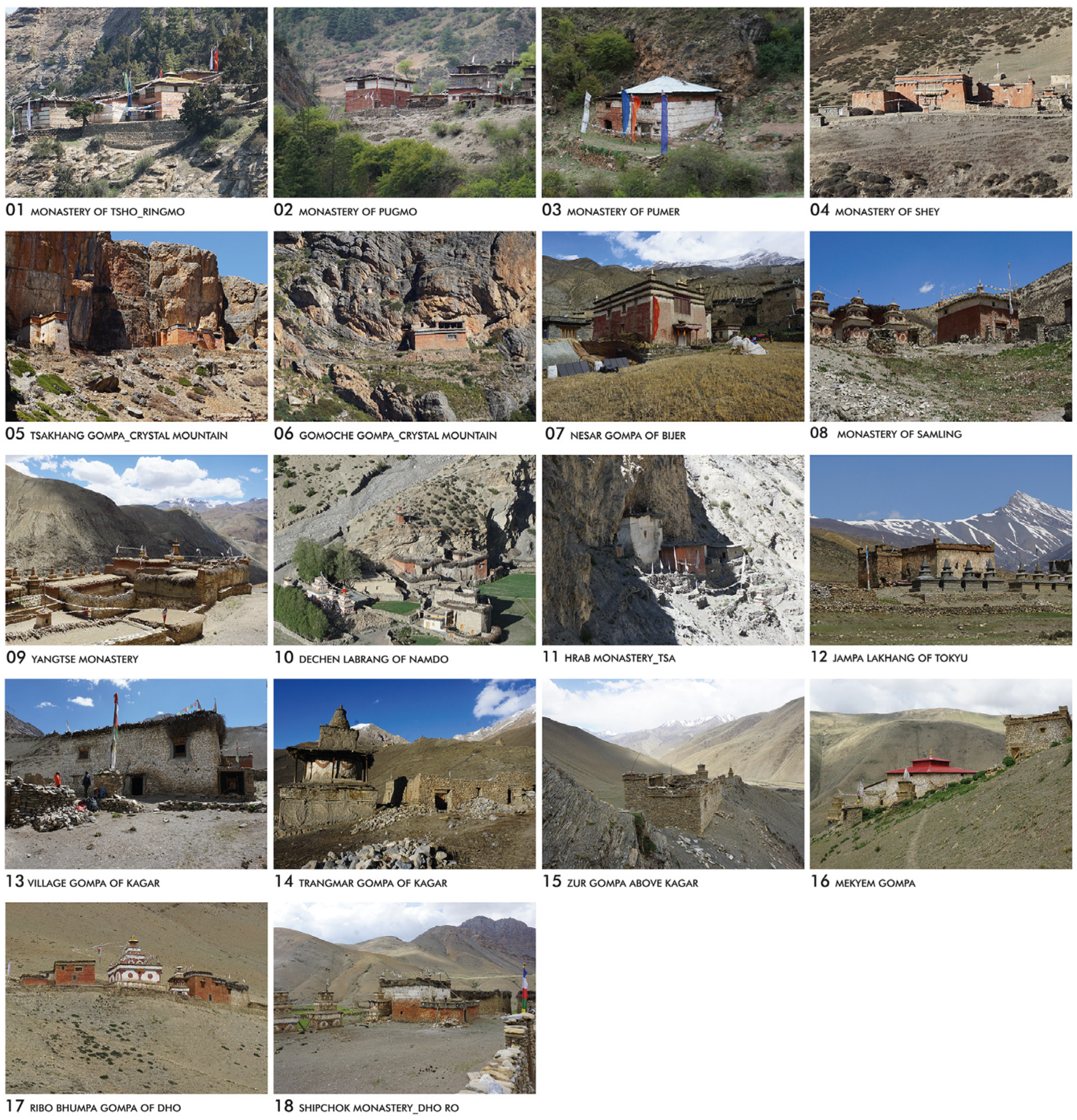
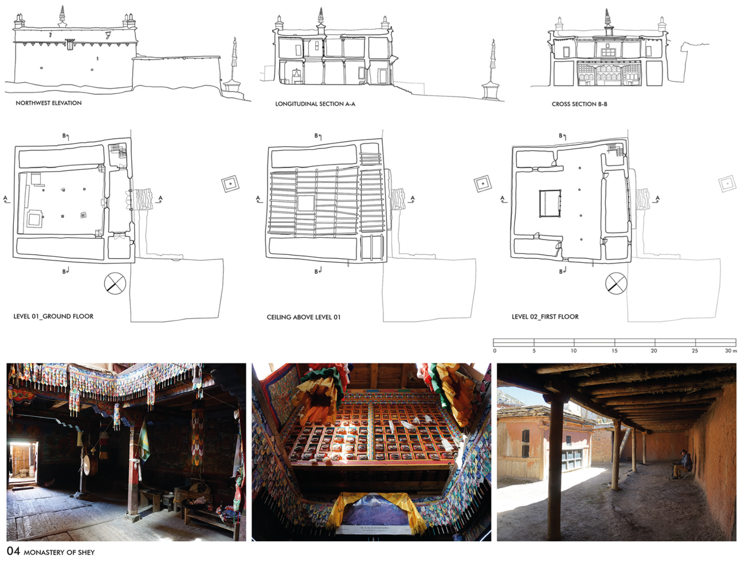
Following the research conducted in recent years, the architectural documentation of eighteen Buddhist sites in Dolpo has now been made available. Of these listed sites, fifteen ensembles have been comprehensively surveyed and documented (Figure 6 and Table 1).

3. Results

3.1. The Sacred Landscape

The temples and monasteries of Dolpo are part of an overarching reference system, a sacred landscape that has developed over the centuries under the (sometimes changing) affiliation of Buddhist schools in the cultural area of the Western Himalayas. In this context, a number of centres can be identified that have provided important impulses for this sacred landscape, which is characterised by a series of architectural structures and signs. The site comprises monasteries and temples, in addition to shrines (chörten), prayer wheels, prayer walls, sanctuaries and engraved rock slabs (mani stones). These structures are located along the paths and trade routes, particularly in the vicinity of monasteries and temples. The region around Bijer (Vijer) in the Nangkhong Valley is dominated by the Mukpo Rong, the ‘Purple Mountain’, and was an early impulse centre, starting between the 11th and 13th centuries. The Bonpos and Sakyapas came from Tibet and founded the monasteries of Samling and Bijer in this area [20]. Since the 13th century, another religious centre developed around the Crystal Mountain, south-east of Bijer and Samling. The Crystal Mountain, named ‘Dragon Roar’, and its outer and inner circumambulation paths (known as kora) are still the most important pilgrimage site in Dolpo, which has developed since the end of the 13th century. The cave behind the Gomoche Gompa, known as the Vajra Cave of Shey, is one of the first hermitages mentioned in the area, as is the nearby rock of Tsakhang [21]. From the 15th century onwards, two further religious centres developed in Dolpo under the patronage of Mustang, one in the northernmost Panzang Valley, where the monastery of Yangtse was established, and another in the Tarap Valley, where the Jampa Lakhang of Tokyu and the Trangmar Gompa of Kagar were founded. The Tsakhang Gompa, founded in the 16th century [6] (p. 228), and the Shey Sumdo Monastery, also known as the Crystal Monastery—founded in 17th century [21], which are both part of the Crystal Mountain site, show the development of later temple typologies in Dolpo. Later, from the 17th century onwards, Bon centres were established in the central regions of Dolpo. The first Bon temple in the Tarap Valley was built in Merphu, in a side valley south-west of Dho Tarap. From there, further monasteries were established in the Phoksundo region, such as the gompas of Pugmo, Pumer and Tsho near Ringmo. At the end of the 18th century, the Merphu Monastery fell into ruin, and the local Bon centre was moved to Shipchok, in a side valley to the east of Dho Tarap [6] (pp. 142–145, 308).

3.2. The Choice of the Site and the Orientation of the Structure

The choice of a site for a temple or a monastery is always linked to a certain narrative, a founding story, a directive from the gods or from the souls of nature, who make their will clear through certain signs. There are a number of religious or historical reasons that justify the choice of the site. It is often an exceptional place: a mountain or a terrace overlooking a river or a river junction. Nearby mountain peaks, lakes or cliffs are then part of a sacred area demarcated by votive buildings, prayer walls and enclosures. This shows that the sacralisation of an unknown area was always understood as a cosmic consecration. It is the mystical reflection of the world itself and a projection of its cosmic powers [22]. In addition to the traditional founding myths, whose potential for interpretation is primarily religious and mythological, Tibetan sources also contain general references to the choice of sites. Translations and explanations of some of these sources, published by Jackson and Thubten in 1979, describe the ‘examination and taking possession of the building site’, which illustrates the criteria for choosing the right site as follows:
‘One should seek out a place for building a temple in places that have the following: a tall mountain behind and many hills in front, two rivers converging in front from the right and left, a central valley of rocks and meadows resembling heaps of grain, […]. The good characteristics called the four Earth-pillars are: a wide expanse in the east, a heap in the south, a rounded bulge in the west, and in the north a mountain like a draped curtain’ [23] (p. 29)
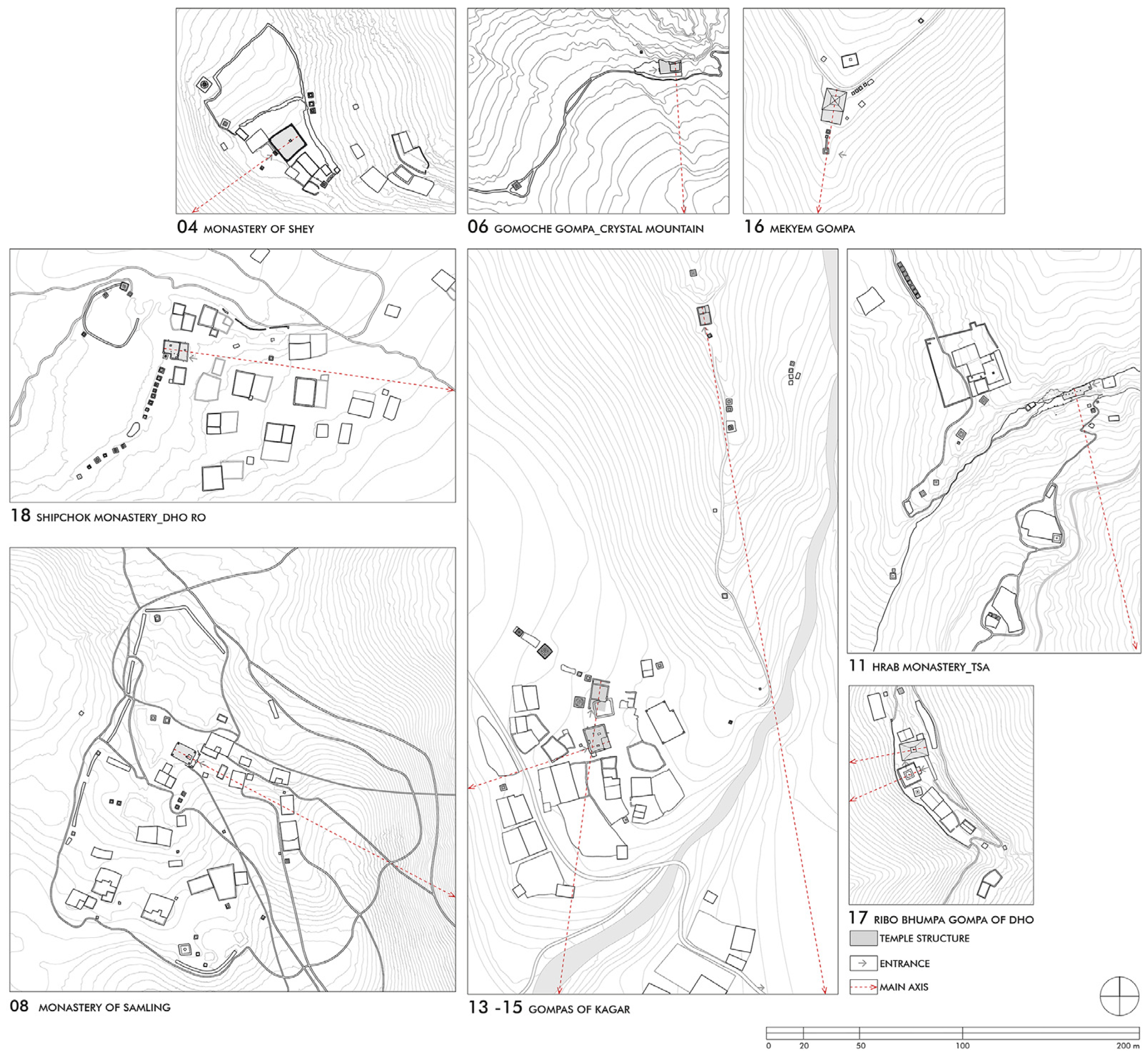
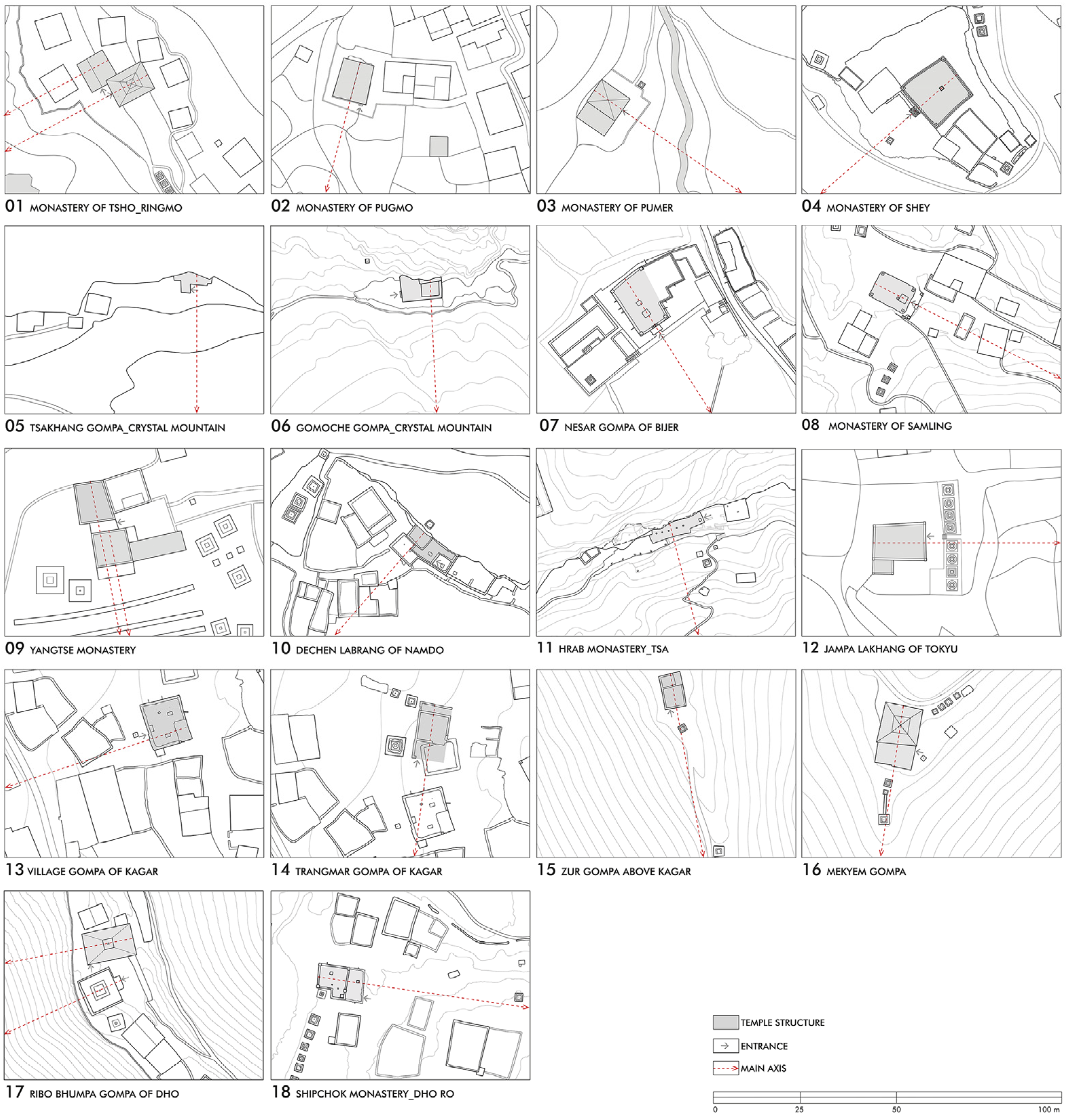
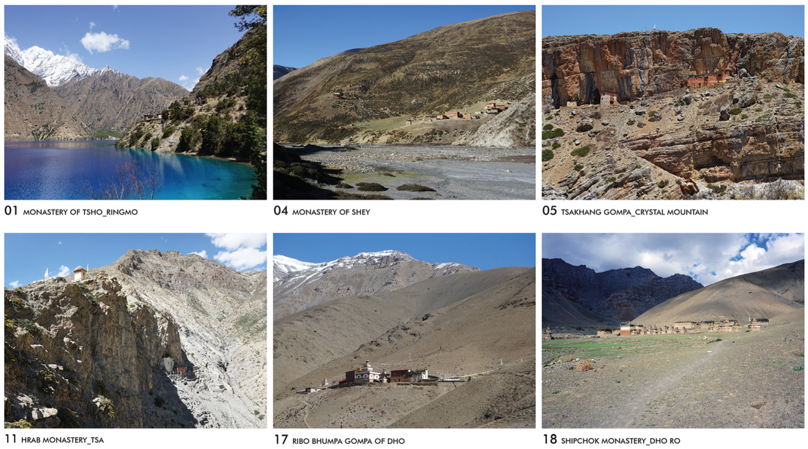
In fact, many of these attributes can be found in the sites of Dolpo’s temples and monasteries. Compromises or limitations in this regard are due to geographical factors, such as the topography of the valleys and their course, and the position and height of the mountain ranges. Characteristics such as ‘a tall mountain behind and many hills in front’ or ‘a mountain like a draped curtain in the north’ are easily fulfilled at all the sites in the Upper Dolpo. Geographical proximity to the confluence of rivers is also often evident, particularly at the Shey Sumdo Monastery (N° 04), the temples of Kagar (N° 13–15) or the ensemble of Namdo (N° 10). The attribute ‘a wide area in the east’ is difficult to fulfil for geographical reasons. This only applies to the Jampa Lakhang of Tokyu (N° 12) and the Shipchok Monastery (N° 18). But all the sites–such as those along the kora of Crystal Mountain, above Phoksundo Lake or on the mountainside above Dho Tarap–are clearly influenced and dominated by the spiritual notion of a blessed landscape. Therefore, the presentation and analysis of the sites take into account the wider surroundings in order to highlight relevant factors such as sightlines and votive structures (Figure 7).
The choice of site is closely linked to the orientation of the temple: it is defined by the location of the entrance and, even more so, by the main axis of the temple. By aligning the temple or sanctuary with the direction of the solar orbit, the believer achieves a close personal relationship with the cosmos. The preference for an eastern orientation can be observed in many cultures and is directly related to the sunrise. But depending on the date of a temple’s foundation, which is important from an astrological perspective, the point at which the sun rises on the horizon can vary considerably depending on the topography of the surrounding mountains. The orientation is thus closely related to the foundation date and the landscape of the respective sites and therefore shows many different variants and deviations. With regard to the main axis, only one temple that we documented in Dolpo—the Jamba Lakhang of Tokyu (N° 12)—faced exactly east. This is followed by two south-facing temples, seven south-east facing temples and eight south-west-facing temples, which were sometimes only a few degrees away from the east or south or sometimes orientated almost to the west (Figure 8).
As most building sites in Dolpo are located on ascending mountain slopes, the position of the sunrise shifts southwards, as does the orientation of the main axis. But there are undoubtedly also other aspects that play a significant role and are obviously decisive for the deviations in orientation in Dolpo. The animistic conception is still present here and shows that references to nature and narratives about religious places of power (sacred mountains, springs and caves) played an important role in the orientation of temples and monasteries. This principle seems to be effective for the orientation of most temples (Figure 9).

3.3. Building Construction and Material

Traditional construction in this area consists of solid walls–made of stone, rammed earth or adobe bricks with clay mortar and clay plaster–and wooden components used for pillars, beams and ceiling construction, as well as for windows and doors. Due to the regionally available building materials and local building traditions the sites’ locations have a significant impact on the architectural construction of the sacred buildings and their appearance. The differences between the wood-rich areas of Lower Dolpo and the high-altitude areas of Upper Dolpo, which correspond to the climate and vegetation of the Tibetan Highlands, are evident in their building traditions. Lower Dolpo has a tradition of stone and timber construction with flat pitched roofs, while Upper Dolpo has a tradition of mixed construction using stone and earth masonry or rammed earth walls with flat roofs. Accordingly, in Upper Dolpo the limited availability of timber in larger dimensions, which must be transported by yak from other regions, imposes clear constraints on construction dimensions and techniques.
To date, the timber supply in Dolpo is secure, with tree felling regulated by the national park authority. All other building materials that lack local availability, such as window glass or corrugated iron, must be transported to the northern regions by helicopter, mule or porter. Additionally, structural damage resulting from earthquakes is a recurring challenge, as it is everywhere in the Himalayan region. Damage from the 2015 earthquake showed that traditional rammed earth buildings are more resilient than adobe buildings. This has led to a certain revival of this construction method in some areas. On the other hand, increasing rainfall combined with the decreasing maintenance of flat roofs has led to structural damage in many places due to water ingress in the roof area. In response, more and more tin roofs are being erected over the traditionally flat roofs, greatly altering their appearance, and in some cases, overstressing their underlying structure.
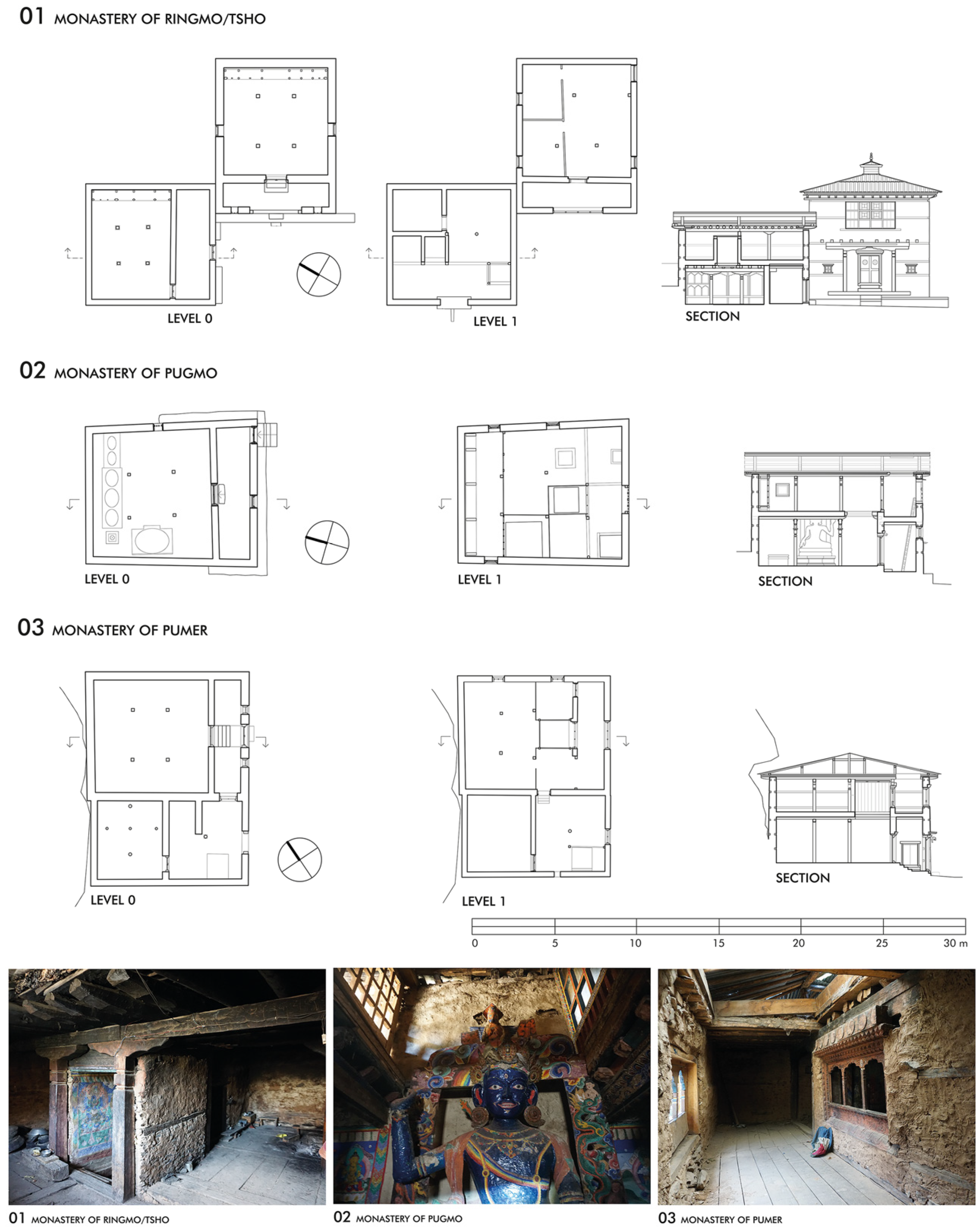
The examination of the preserved temples clearly shows that all of them consist of solid stone walls with clay mortar and clay plaster. The temples in Upper Dolpo feature the designs of the Tibetan highlands, which were originally single-storey. In Lower Dolpo, wooden tie rods were incorporated into the masonry to enable stable multi-storey construction, as can be seen in the temples in Ringmo (N° 01), Pugmo (N° 02) and Pumer (N° 03). The interior walls of the assembly halls are traditionally covered entirely with murals, the condition of the clay plaster used for the paintings often reveals whether and how these decorative features were once executed. The only high-quality example of wall paintings was undoubtedly the Trangmar Gompa in Kagar (N° 14), but the last remains were destroyed in 2023. There are also examples of painted decorations of different ages and qualities in other temples, by example in the Nesar Gompa of Bijer (N° 07), the Jampa Lakhang of Tokyu (N° 12), the extraordinary chörten-chapel next to the Ribo Bhumpa Gompa in Dho (N° 17), and the Shipchok Monastery (N° 18). Repairs and later additions and extensions often show a change in construction and materials, which can be seen in the masonry but also in the workmanship of the wooden components. The case studies will subsequently illustrate how these construction stages are evident in the buildings, thus providing insight into their original appearance.

3.4. Building Typology and Room Configuration

There are different typologies of sacred buildings in Dolpo which can be distinguished according to their function and architectural structure. The elementary form of the square plays a pivotal role in the temple typologies, as it does in numerous Buddhist sites, at times manifesting in the external cubature, and at other times, in the layout of the interior. The various names of temples are often poetic in their literal meaning or linked to a property status. Thus, they sometimes refer to the function of the building or to a status that may have changed during the course of history. For example, the term gompa (Tib. dgon-pa), often used for monasteries in the Dolpo region, but also for village temples or retreats, literally means ‘a place of silence’. The term lakhang (Tib. yul-gi-lha-khang), literally meaning ‘house of the gods’, is sometimes used for village temples, and the term labrang (Tib. bla-brang), literally meaning ‘property of an incarnate lama’, is generally used for private chapels in a residence. The term tsakhang (Tib. tsam-khang) refers to a hermitage in a remote location. The most common sacred structures, which can be found in large numbers on the way to and near temples, are named chörten (Tib. mchod rten), literally meaning ‘place of sacrifice’, which appear in many different types and sizes [9] (pp. 31–32).
Of all the temple sites, the monasteries are the largest structures, often consisting of a cluster of different buildings. They are usually grouped around a courtyard, with the temple itself occupying one side or the centre, surrounded by other buildings that serve as dormitories, kitchens, storerooms and stables. In the main building, the assembly hall is located on the ground floor. The courtyard is used for gatherings of pilgrims and members of the community during ceremonies and is used as an open space for the performance of religious festivals that take place on the site. Typical examples of this spatial arrangement are the Yangtse Monastery (N° 09) in the Panzang Valley and the Shey Sumdo Monastery (N° 04) of the Crystal Mountain. Other monasteries, such as Samling (N° 08), which is located on a basin-like plateau not far from Bijer, have developed into small settlements over time. Examples such as the Ribo Bhumpa Gompa (N° 17)—where the buildings and open courtyards are lined up along the slope of the hillside–and the Thasung Tsholing Monastery in Tsho (N° 01)—which is situated on a terrace above the banks of the Phoksundo Lake–show how strongly the topography influences the arrangement of the buildings and the organisation of open spaces.
In contrast to it, the village temples are located within or near a settlement. Again, the assembly hall is located on the ground floor. These temples are mostly free-standing, although in some cases, extensions and annexes have been added over time. Examples include the Nesar Gompa in Bijer (N° 07) and the Jampa Lakhang in Tokyu (N° 12), as well as the Kagar Labrang (N° 13), where the assembly hall is on the ground floor and the lama’s private chapel resides above it. Private chapels on the other hand are usually an integrated part of private homes, located on the upper floor and reserved for personal worship. Particularly interesting examples are integrated into lamas’ residences in monasteries, such as in Hrab (N° 09), where the chapel on the fourth floor extends into a cave in the rock face behind it. Finally, there are the hermitages, which are defined by their function as remote places of meditation where a monk can retreat into seclusion. This can be a cave in the rock or a small temple with an assembly room on the ground floor. Over the centuries, these have sometimes grown into multi-storey buildings, leaning against the rock face like small fortresses. The Tsakhang Gompa (N° 05) and the Gomoche Gompa (N° 06) near Shey and the Hrab Monastery (N° 11) are good examples of these different structures.
In terms of interior organisation, most temples in Dolpo follow the traditional tripartite division, with an entrance area or veranda, a square or rectangular assembly hall and an altar at the rear of the room, all organised along the central axis. There are always clear reasons for deviations from this scheme, such as limited space or structural changes. The defining characteristics depend on the size and structure of the assembly hall. The smaller type has an almost square hall with a ceiling construction supported by four pillars–making it three bays wide and three bays deep–which is literally called ‘the four pillars and eight beams’ (Tib. kabzhi gdung-brgyad). The larger type with a rather rectangular hall, called ‘the six pillars and the nine beams’ (Tib. kadrug-gdung-dgu), refers to a ceiling construction supported by six pillars that is three bays wide and four bays deep [9] (pp. 25–26).
The name always refers to the free-standing pillars in the hall; lateral pillars, which sometimes form an additional support in front of the side walls, are not counted in this system. In this regard, it is also interesting to note how the number of beams is counted. As a rule, the main beams running transversely to the main axis are counted, giving six beams with four pillars and nine beams with six pillars. In a temple with four columns, the inner secondary beams must also be counted. These run at right angles to the main beams and emphasise the central square in the ceiling. This results in a count of eight beams. In general, the size of an assembly hall reflects its function (e.g., hermitage, village temple or monastery) and the size and importance of the religious community that founded it. Conversely, certain types are also preferred depending on the Buddhist school to which they belong.

3.5. The ‘Six Pillar and Nine Beams’ Temple

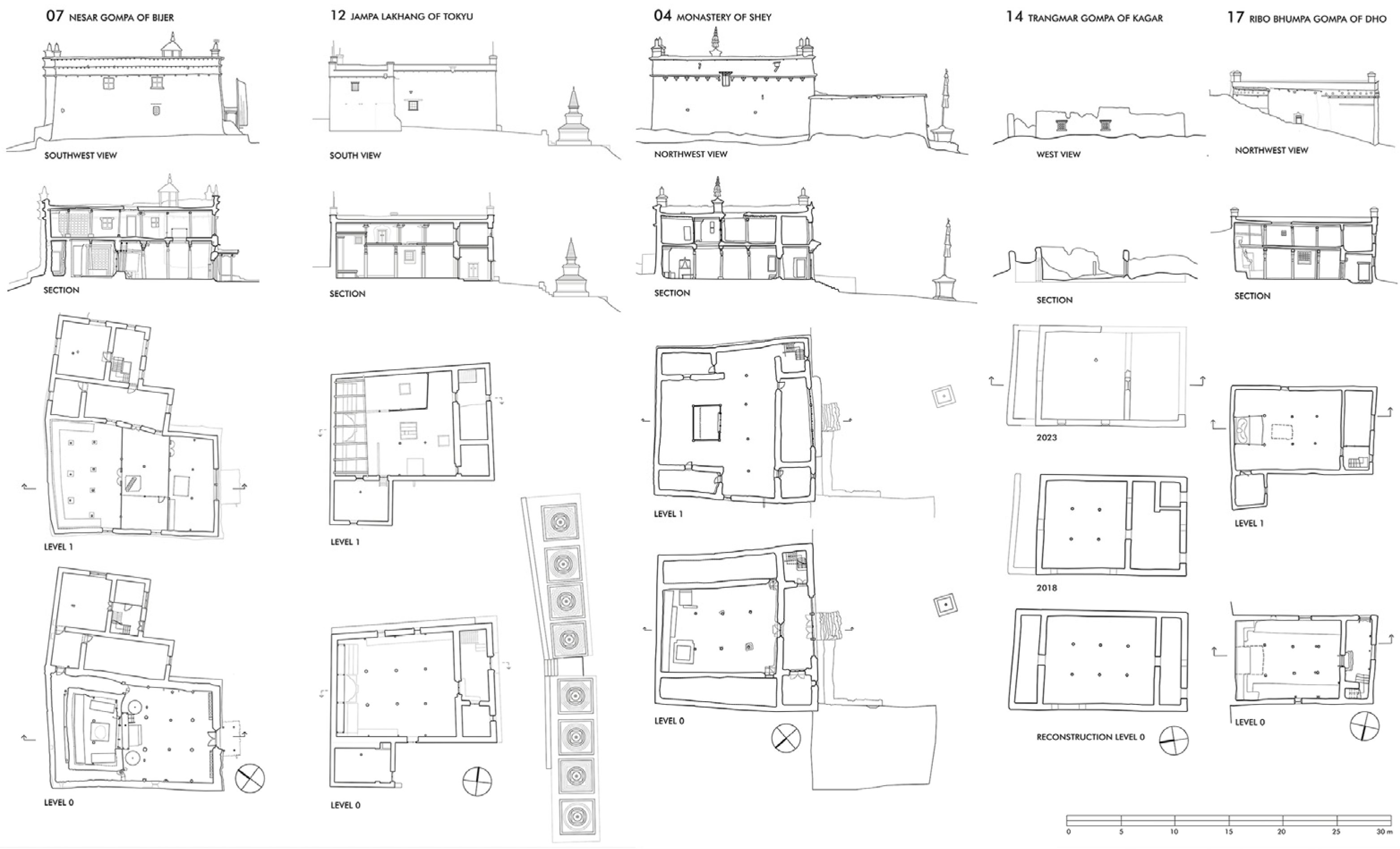
This category of larger temples includes five of the temples we documented in Dolpo. The Nesar Gompa in Bijer (N° 07), the Jampa Lakhang in Tokyu (N° 12), the Trangmar Gompa in Kagar (N° 14), the Shey-Sumda Gompa (N° 04) and the Ribo Bhumpa Gompa in Dho (N° 17) are each structured by six pillars and a ceiling construction that is three bays wide and four bays deep in the assembly hall. The total areas, including the outer walls, range from 110 m2 (Ribo Bhumpa Gompa) up to 216 m2 (Shey Sumdo Gompa). In between are the Nesar Gompa at 166 m2 and the Jampa Lakhang at 158 m2. The total area of the Trangmar Gompa, which was demolished in 2023, was originally about 149 m2. The external dimensions of these temples range from 8.4 to 15.5 m in width and from 13.4 to 15.7 m in length. Again, each of these temples has two storeys, giving a building height between 6.1 m (Tokyu) and 7.9 m (Bijer). The Ribo Bhumpa Gompa (as well as the nearby Mekyem Gompa) was later extended with an additional roof construction above the flat roof, increasing the external height of 6.0 m by a further 2.50 m.
The more comparable size of the assembly halls ranges from 70.5 m2 (Ribo Bhumpa Gompa) to 101.3 m2 (Jampa Lhakhang Tokyu). In between are the Nesar Gompa in Bijer at 71.3 m2 (the sanctum and the ambulatory around it comprise a further 50.3 m2), the Trangmar Gompa (which no longer exists) at 82 m2 and the Shey Sumdo Gompa at 84.4 m2. The interior room heights of the assembly halls range from 2.8 m (Ribo Bhumpa Gompa) up to 3.5 m (Nesar Gompa)—measured from the ground floor up to the board layer of the ceiling. The height of the room on the upper floor varies between 1.9 m (Jampa Lakhang) and 2.6 m (Nesar Gompa). However, it is evident that the upper storey’s increase in height at Nesar Gompa is attributable to construction work undertaken after the year 2000. Photographs taken of the temple in the 1990s show that the upper floor was only about half as high and was therefore difficult to use. Despite the fact that the assembly halls of the four preserved temples of this type are structurally similar, a clear distinction in design is evident amongst them (Figure 10).

3.5.1. Case Study No. 1: The Nesar Gompa in Bijer

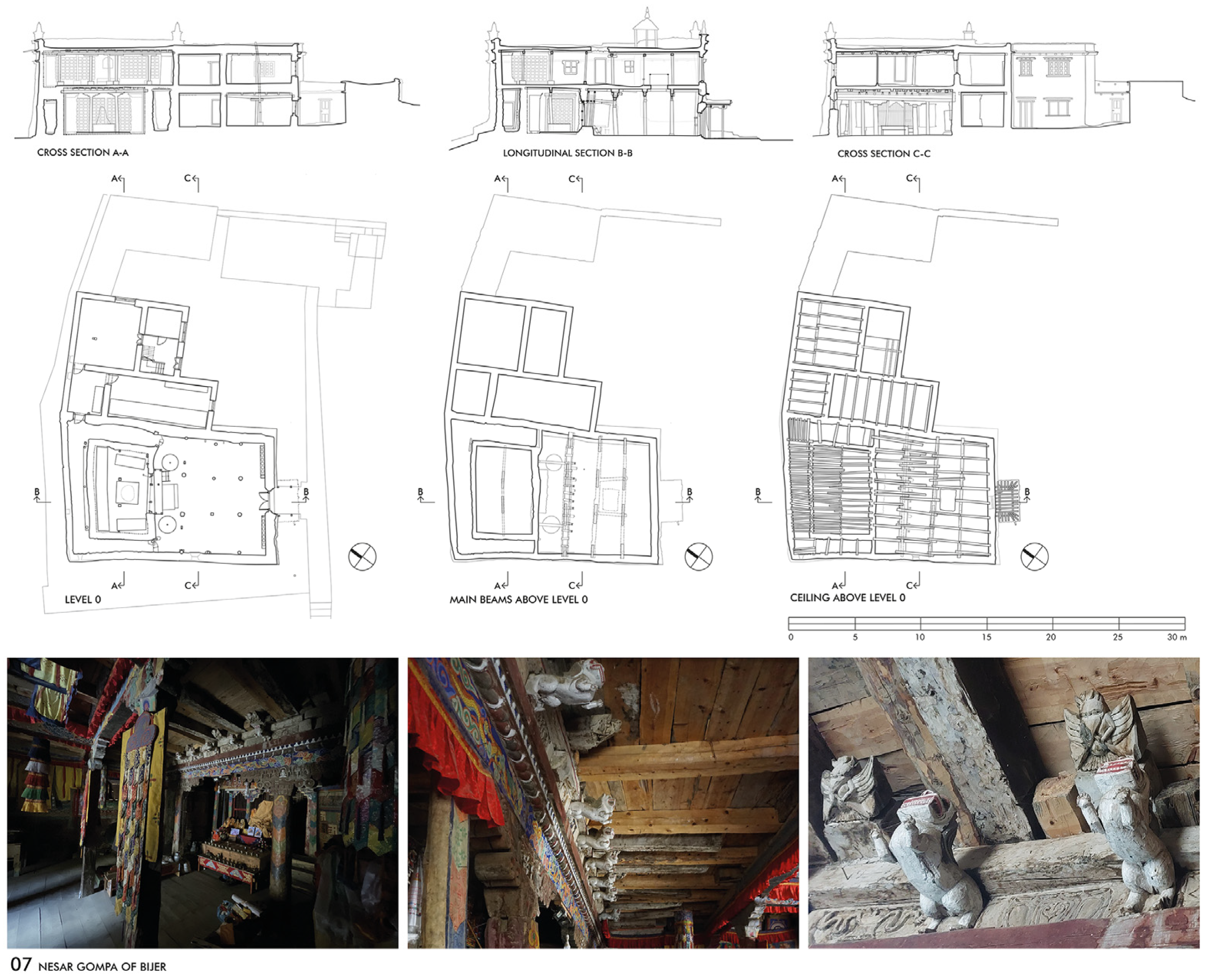
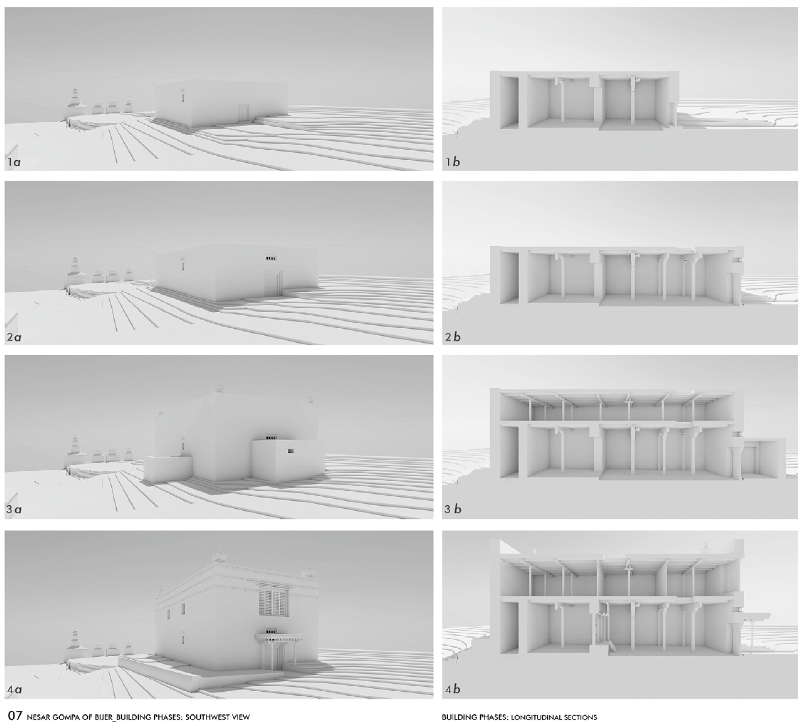
The Nesar Gompa in Bijer (N° 07) represents a special case in which an early typology is evident, characterised by a circumambulation around the sanctuary. According to written sources, the temple can be dated back to the early 13th century, but material investigations reveal an earlier dating of back to the 11th century. An extension of the structure took place in the 14th century [11] (pp. 49–50). Based on the analysis of the surveyed data, it is possible to identify a number of structural changes that allow the construction stages to be determined. The ground floor comprises a six-pillar assembly hall (with six more supporting pillars on the side walls), an adjoining two-pillar sanctuary and a narrow ambulatory around it. Today, the assembly hall in front of the sanctuary is 8.42 m wide and 8.36 m deep, making it approximately square, with a room height of 3.50 m. The interior of the sanctuary is 6.20 m wide and 3.84 m deep, covering an area of 25.2 m2, with a room height of 2.33 m up to the planks of the ceiling. The opening to the assembly hall is three m wide; however, a gate with a smaller door restricts access. Today, parts of the library are housed in floor-to-ceiling wooden shelves on three sides of the room, with an altar platform in the central area between the two channelled wooden pillars.
The floor of the ambulatory, located to the left and right of the sanctuary, is positioned in alignment with the side walls of the assembly hall. This floor is elevated two steps above the standard level of the hall’s floor. It circumvents the sanctuary, measuring between 0.86 and 1.60 m in width, with a maximum height of 3.24 m at its rear. The rising masonry of the ambulatory and the sanctuary has lost its top layer of plaster in many places, and various repair measures are visible, suggesting the presence of structural damage. A notable deviation from the geometry pertains to the configuration of the ground floor, which deviates significantly from a rectangle and exhibits an irregular trapezoidal shape: at the front area, the hall is 8.42 m wide, whereas at the rear, in the ambulatory behind the sanctuary, it is 9.90 m wide—an increase of 1.40 m. Conversely, the deviation of the side walls is less pronounced, with the total length of the south-western inner wall measuring 14.57 m and the north-western wall measuring 14.88 m, representing a deviation of 31 cm.
There is no doubt that this irregularity is the result of different construction phases or repairs. The workmanship of the wooden parts clearly supports this assumption. The different shapes and wood carvings of pillars, capitals and consoles allow us to deduce their age and stylistic classification, i.e., the possible stages of their construction or repairs. These differences are particularly noticeable in the assembly hall: above the first row of pillars, in front of the sanctuary with its ambulatory, there is an older crossbeam with wood carvings supported by eight consoles in the shape of lions. Directly above, four wood-carved beam heads with representations of Garuda (a half-human, half-eagle-shaped mount) are arranged irregularly. Above this, parts of an older wooden ceiling have been preserved, which protrude freely by up to 1.30 m. These components strongly indicates that the original structure has been altered, either through repair or extension (Figure 11).
The question remains: what may the temple have looked like before the alterations? Typological comparisons with temples of similar spatial configuration are revealing: the Main Temples of Tabo and Nyarma in Ladakh, as well as the Golden Temple of Lalung in Himachal Pradesh, show an early temple typology–consisting of an assembly hall with a circular ambulatory around a sanctuary–dating back to the 10th century [24,25]. The dimension and proportion of the sanctuary, including the circumambulatory, are indeed similar, although the size of the sanctuary and the assembly hall are different. Even if the quality of the architectural workmanship of the Nesar Gompa is not comparable to that of the reference buildings, one can clearly assume a relationship to this early temple type, both in form and in dimensions, which was undoubtedly essential on a symbolic level. Accordingly, it is likely that a meeting hall–maybe of a smaller dimension–had already been located here prior to the structural changes in the 14th century (Figure 12 and Figure 13).

3.5.2. Case Study No. 2: The Jampa Lakhang in Tokyu

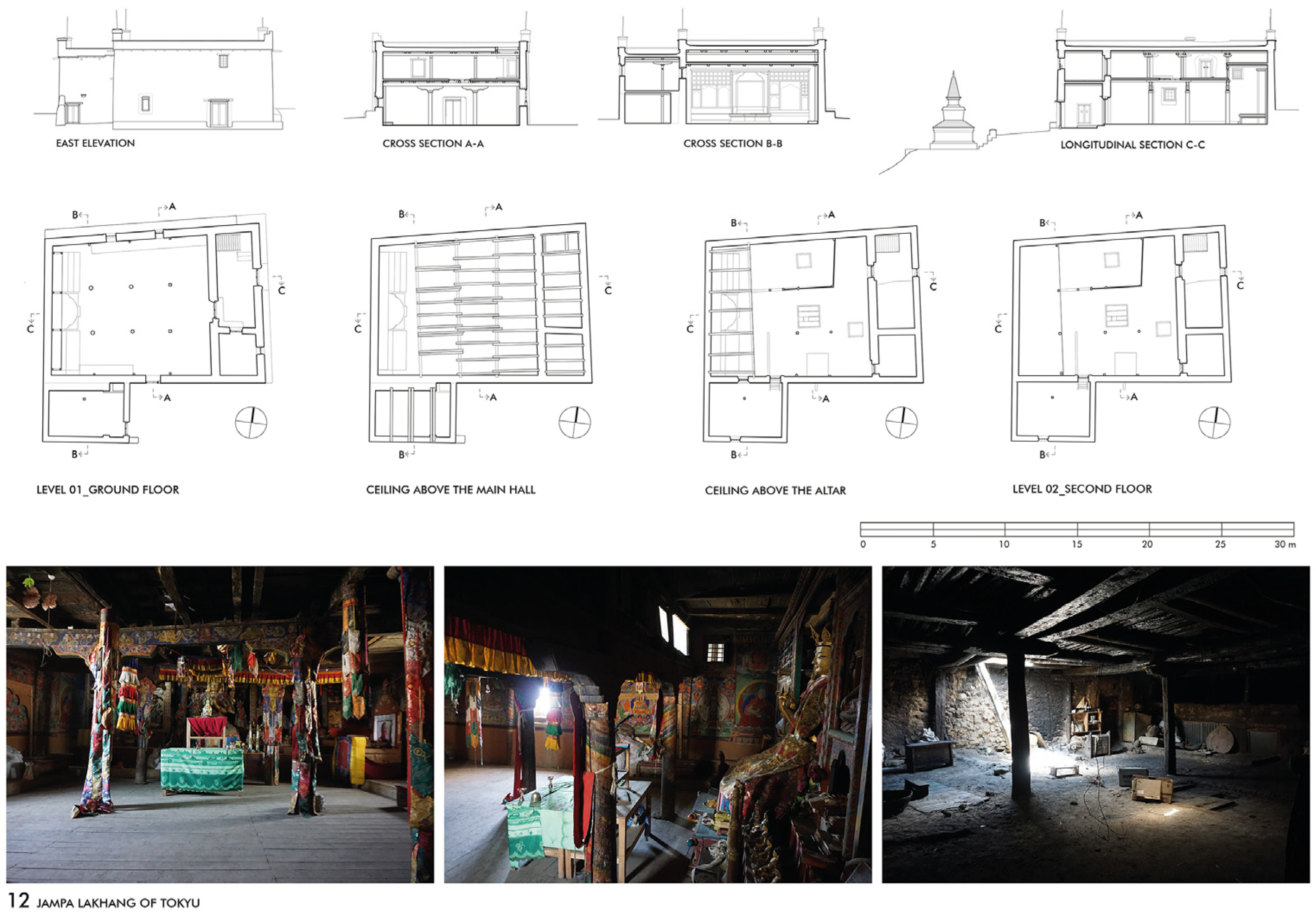
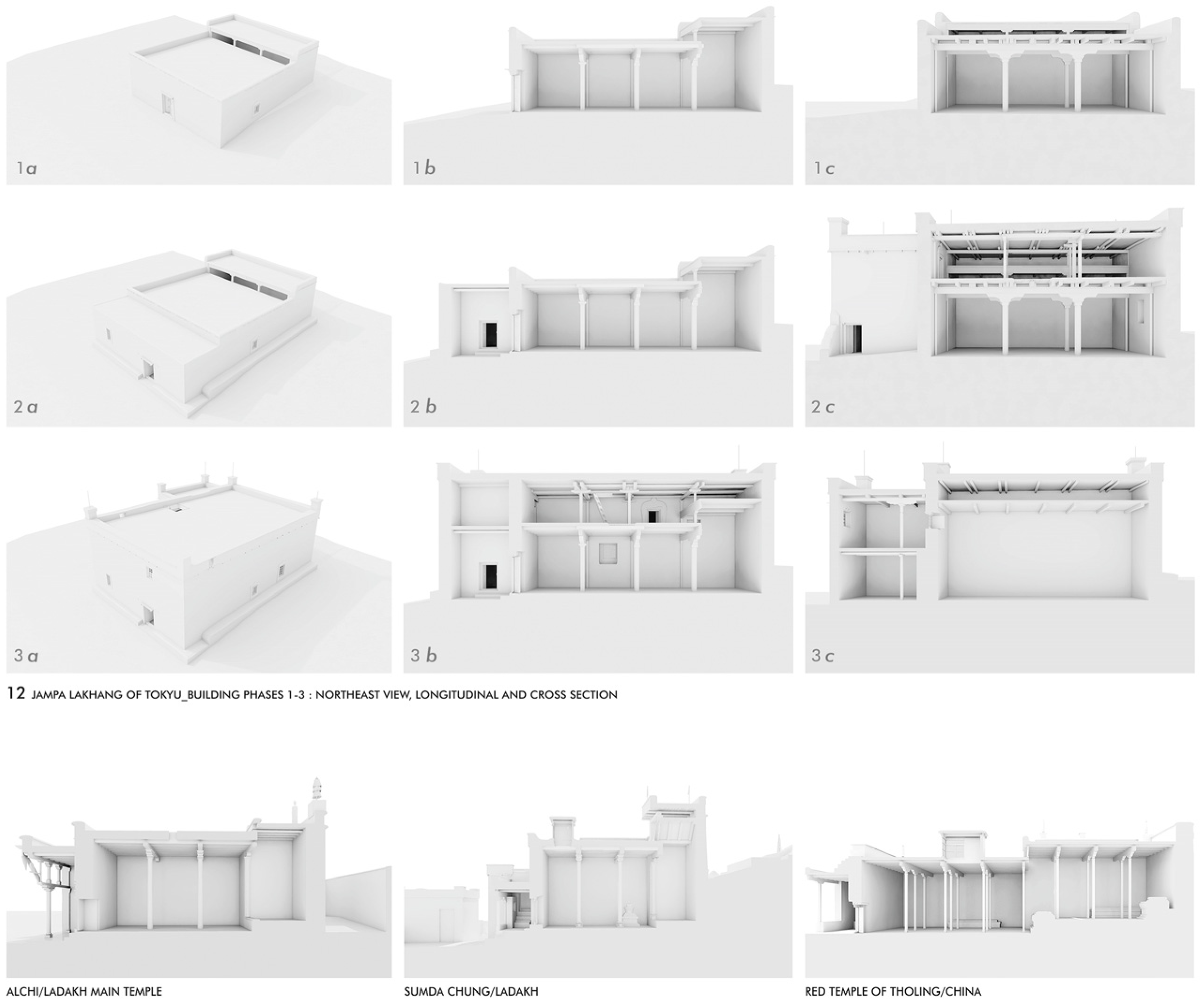
As can be seen, an analysis of the various phases of construction is fundamental to the understanding of the structure and for a typological classification. In this context, the construction phases of the Jampa Lakhang of Tokyu (N° 12) are also significant, as evidenced by the building survey of the structure. Written sources indicate that the Jampa Lakhang of Tokyu was founded in the 15th century, although no paintings from this period have survived [11] (p. 41). Today, the temple is two-storeyed and measures up to 11.69 × 15.87 m on the outside, with the facade on the east side reaching 6.09 m up to the attic above the roof structure. An annex on the south side, covering 4.24 × 5.99 m, also extended over two floors in 2019, but the upper floor was removed before 2023.
The entrance to the vestibule is situated on the eastern side of the structure, deviating from the conventional positioning at the centre of the facade. In the vestibule exists a staircase to the upper floor on the right and a separate room with a floor-to-ceiling prayer wheel on the left. In contrast, the entrance to the assembly hall is once again located along the central axis. The interior of the hall is 9.92 m wide on its eastern side and 10.88 m deep along the central axis. The western rear wall, measuring 8.93 m, is 0.79 m narrower than the eastern front wall, resulting in a floor plan of slight trapezoid form. The ceiling is supported by six pillars and nine main beams, which were additionally supported by three round pillars on each side next to the side walls. In the central area of the assembly hall, the room height is 3.07 m, but in the rear quarter of the room–in front of the west wall–the ceiling is 1.05 m higher, measuring 4.12 m. This area, which is occupied by floor-to-ceiling altar shelves and pedestals, was originally lit from above across the entire width of the room. The framing of these light openings is well preserved but has lost its functionality due to the construction of an upper floor. In addition, the originally open lantern is still clearly visible in the central area of the ceiling above the assembly hall. Structural changes are also evident in the area of the vestibule, as it is atypical for the entrance portal not to be located on the central axis (Figure 14).
Thus, the analysis shows that the original single-storey structure has been reshaped with extensions. This has significantly altered the cubature and therefore the appearance of the building. The spatial concept of the ground floor–with an over-height altar area allowing light to be directed to the main image–shows similarities with early temple buildings in Ladakh, such as the Dukhang of Alchi and the temple of Sumda Chung, founded in the 12th century. This spatial concept was also implemented in later temples of the 15th century, such as the Red Temple of Tholing in Western Tibet (Figure 15).

3.5.3. Sacred Chambers

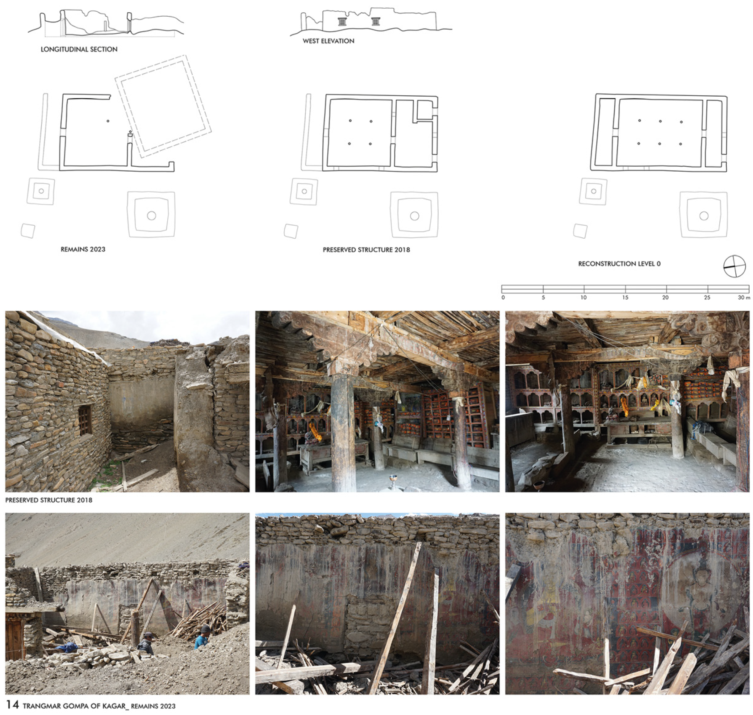
Another notable feature of the spatial programme is the presence of secret chambers, which are found in various forms in some of the temples investigated in Dolpo. These chambers are typically reserved for ritual acts of the responsible lama, in accordance with the customary practices observed in the chapels of tutelary deities within Buddhist temples. Examples of this can be found in the Trangmar Gompa of Kagar (N° 14) and in the Shey Monastery (N° 04). In the Trangmar Gompa, this secret chamber was accessed through a door in the centre of the rear wall of the assembly hall. The chamber was 8.11 m wide and 2.06 m deep, giving it an area of 16.70 m2. Photographs taken before the collapse of the building attest to the high quality of the wall paintings, both in parts of the assembly hall and in the chamber behind it [11] (pp. 206–208). During the demolition of the remains in June 2023, we were able to precisely document the former entrance door to the chamber, which had previously been hidden behind the altar shelf. The frame of the mural showed that this door was part of the original spatial conception (Figure 16).
An extended variation of sacred chambers can be found in the Shey Monastery (N° 04), where two symmetrically arranged, narrow rooms, located on both sides along the assembly hall, extend the full length of the hall. A bricked staircase with an entrance door to each of the chambers is located in the corner of the side walls, next to the entrance wall of the assembly hall. These chambers, 10.65 m long and 2.00 to 2.50 m wide, with a floor area of about 25 m2 each, are both unlit and are said to be used as storage rooms today (Figure 17). Unfortunately, we have not yet been able to look inside them, as the keys have not been found. The original use was undoubtedly a ritual one; the arrangement likely suggests chapels for protective deities.

3.6. The ‘Four Pillar and Eight Beams’ Temple

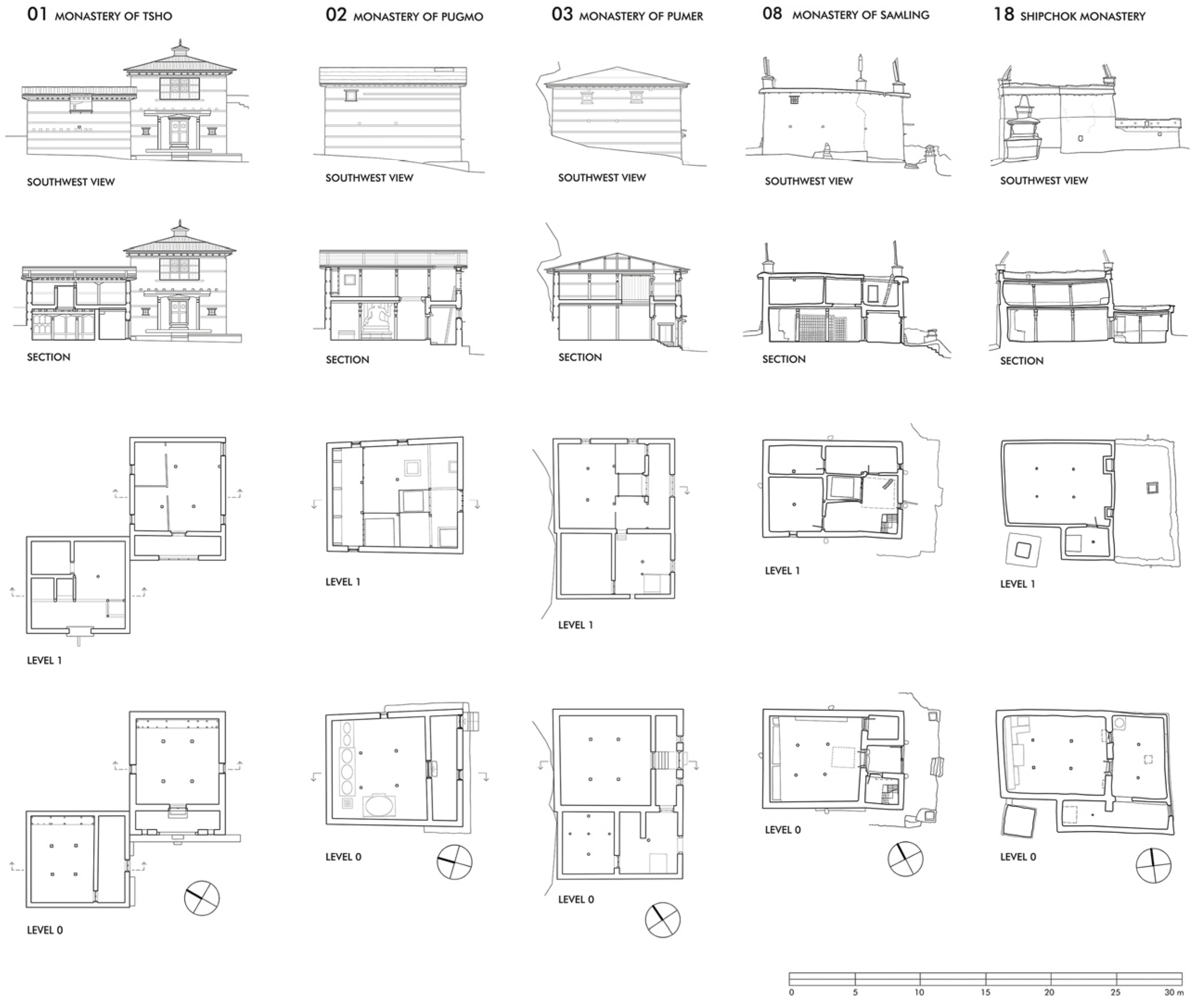
Eight of the documented temples in Dolpo belong to this category, which means they tend to be smaller temples with a main hall structured by four pillars and a ceiling construction that is three bays wide and three bays deep. In most cases, this corresponds to an almost square floor plan of the assembly halls. The Gomoche Gompa (N° 06), the Kagar Labrang (N° 13) and the Mekyem Gompa (N° 16) reflect this spatial concept, as do all the documented Bon temples in Samling (N° 08), Shipchok (N° 18), Tsho (N° 01), Pugmo (N° 02) and Pumer (N° 03). The total floor areas of these temples, including the outer walls, range from 59 m2 (Tsho, Old Gompa) up to 187 m2 (Mekyem Gompa). In between are the New Gompa of Tsho at 66 m2, the Gomoche Gompa at 73 m2, the Samling Gompa at 81 m2, the Pugmo Gompa at 102 m2, the Shipchok Gompa at 110 m2 and the Pumer Gompa at 126 m2. These floor areas correspond to external dimensions of 5.5 m to 12.9 m in width and 9.7 m to 17.4 m in length.
These large variations in dimensions between similarly structured temples can be attributed to adjacent rooms and later additions, such as vestibules or other structural changes. A better reference for comparison is therefore the size of the assembly halls, which range from 28.4 m2 (Gomoche Gompa) up to 55.1 m2 (Pugmo Gompa). In between are the assembly halls of the Old Gompa of Tsho at 31.5 m2, the Kagar Labrang at 40.2 m2, Mekyem at 43.3 m2, Samling at 44.7 m2, Shipchok at 45.8 m2 and Pumer at 47.1 m2. Each of these temples is two-storeyed, which corresponds to a building height between 4.7 and 7.2 m. The effect of the building height is sometimes exaggerated by placing the buildings on a terrain step and emphasising the corners with superstructures. The temples of Tsho, Pugmo and Pumer are also slightly higher due to their roof construction, which features a sloping roof with wooden shingles instead of a flat roof. The interior room heights of the halls–measured from the floor level up to the board layer of the ceiling–range from 2.2 m (Tsho) up to 3.46 m (Gomoche). The rooms on the upper floors of the Bon temples are approximately the same height as those on the ground floor.
The naming principle is based on the counting of the main ceiling beams and the two secondary beams along the central bay, thereby emphasising the central square formed by these four pillars. This is particularly evident in the beam arrangement of the old temple of Tsho, where the lantern is built into the upper storey above these four beams. These indications suggest that the two-storey structure is part of the overall concept here (Figure 18).
In the other temples, the room heights on the upper floor are usually rather lower. This may be related to the subordinate use of these rooms, but it may also indicate that the temple was originally designed as a single-storey building and that the upper floor was added at a later stage to expand the spatial programme.

3.6.1. Case Study No. 3: The Kagar Labrang

Based on the structural evidence, the analysis of the buildings clearly shows that the earlier temples at Dolpo were designed as single-storey buildings, i.e., that the upper floors were added later. The reasons for this are quite pragmatic, as space was needed for additional uses, such as kitchens for larger gatherings and festivals or additional space for overnight accommodation. As already mentioned, this was undoubtedly the case at the Nesar Gompa in Bijer (N° 07) and the Jampa Lakhang in Tokyu (N° 12); they show structural evidence that the upper storeys date from later phases of construction. In most cases, clues can be found in the structure of the building: a change of construction and material, rooms that deviate from the symmetry, construction joints in the masonry, different wall thicknesses, closed openings in the ceiling construction or bricked-up wall openings, windows or skylights that have lost their function.
The analysis of the building structure of the Kagar Labrang (N° 13) shows how much the appearance of an originally free-standing temple can be changed by alterations and extensions. From the outside, the building resembles a large residential house with an upper storey in the middle of the settlement of Kagar, but the large prayer flag in the front area is a distinctive feature that indicates the function of the village temple. The southern part of the ground floor is occupied by the assembly hall, which is accessible from the vestibule. The main axis of the hall runs from west to east, with the entrance facing west. The richly decorated portal is located opposite the altar wall but is offset from the main axis of the hall, in the left-hand corner. Next to it, on the south side of the vestibule, is a smaller room, which limits the area in front of the hall. The continuous joint along the north side wall of the assembly hall is irrefutable evidence that the adjoining rooms on the northern side were built later. The upper floor above the assembly hall and its front area, which provides space for a storeroom with sleeping quarters and a private chapel, was built in a first extension. Thus, the extension on the north side of the temple and its upper floor, including the stables on the lower floor and the family living quarters on the upper floor, were part of a different phase of construction (Figure 19).
Despite the existence of numerous indications of various repairs or construction phases on the building’s exterior, the logic of its internal structure becomes evident only through detailed architectural documentation, particularly the examination of horizontal and vertical sections. The practice of adding a storey above a single-storey temple with a flat earthen roof led to the emergence of a two-storey typology in the 17th century. Later foundations, such as the Shey Monastery (N° 04), the Mekyem Gompa (N° 16) and the Ribo Bhumpa Gompa (N° 17), show that the buildings were already designed with two storeys. This spatial concept became widespread for all the temples in Dolpo.

3.6.2. Special Features of the Bon Temples

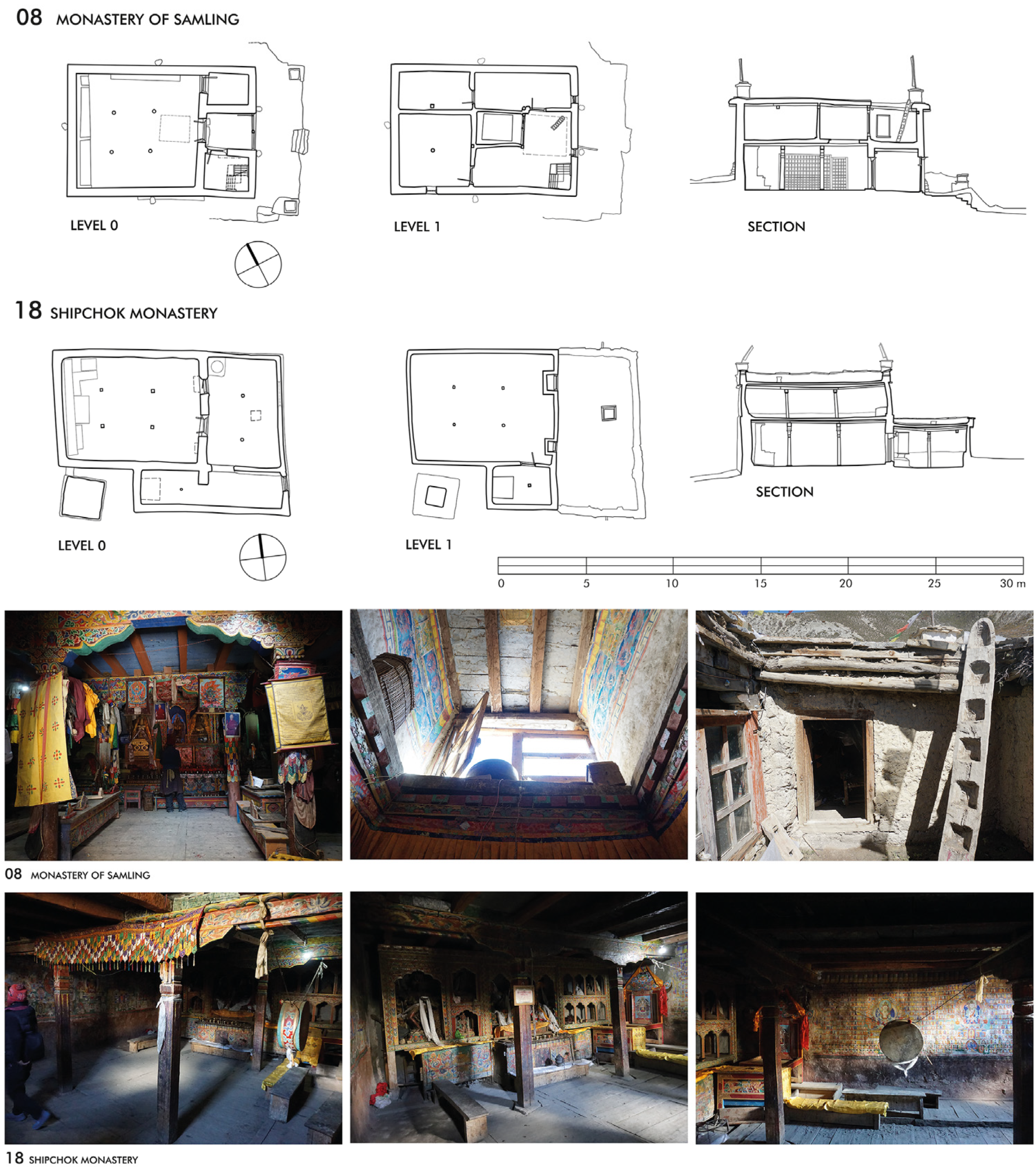
Bon and other Buddhist schools coexist on an equal footing in Dolpo. Due to this practice, it is obvious that mutual influences, in terms of architecture and spatial programmes, are stronger here than in other regions of the Himalayas. The Samling Monastery (N° 08) was founded in the 12th century, but the older structures there had not been preserved. The remaining Bon temples of Dolpo were constructed between the 17th and 20th centuries, reflecting a continuity in architectural tradition. However, it can be hypothesised that the construction programme may have drawn upon pre-existing, traditional building types. The documented Bon temples are all of similar dimension and show that the two-storey structure was already part of an established overall concept. This can be recognised above all by the way the light is always directed from the upper floor down to the ground floor via a wall opening in the facade to a ceiling opening down into the assembly room. The framing of the openings can take the form of a central lantern, with painted sidewalls and ceilings extending openly into the upper floor, as in Ringmo/Tsho (N° 01), Pugmo (N° 02) or Pumer (N° 03) (Figure 20).
In other variations, the light is directed from the upper floor through a small courtyard, as in Samling (N° 08), or through window shafts down into the assembly hall, as in Shipchok (N° 18) (Figure 21).
Another special feature of the Bon temples concerns the organisation of the entrances. While the entrance to the main room (assembly hall) in Buddhist temples is generally organised along the central axis, there are clear deviations from this concept at some Bon gompas with side entrances, such as at the temples of Shipchok and Ringmo. Moreover, the interior of the main hall of these two temples is based on a rather longitudinal floor plan, with the vestibule adjoining the side wall and providing access to the upper floor. On the other hand, it is evident that the later Bon temples, such as the gompas of Pugmo and Pumer, as well as the new gompa of Ringmo, adopted a central access to their assembly halls, and their ground plans clearly approach the square form. Further documentation may clarify whether these conceptual developments can be substantiated by other buildings.

3.7. Overbuilt Cave Sanctuaries and Multi-Storey Room Stuctures

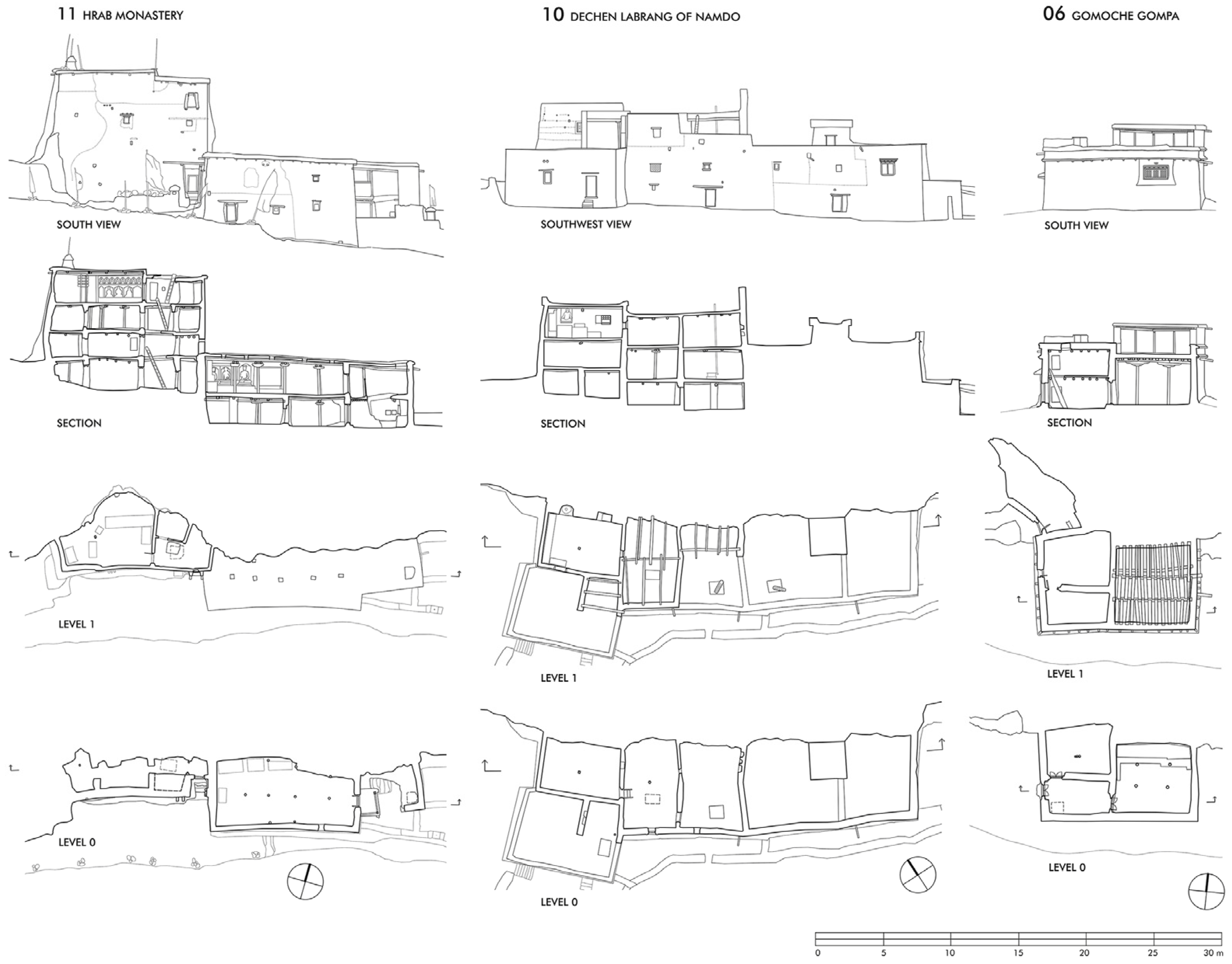
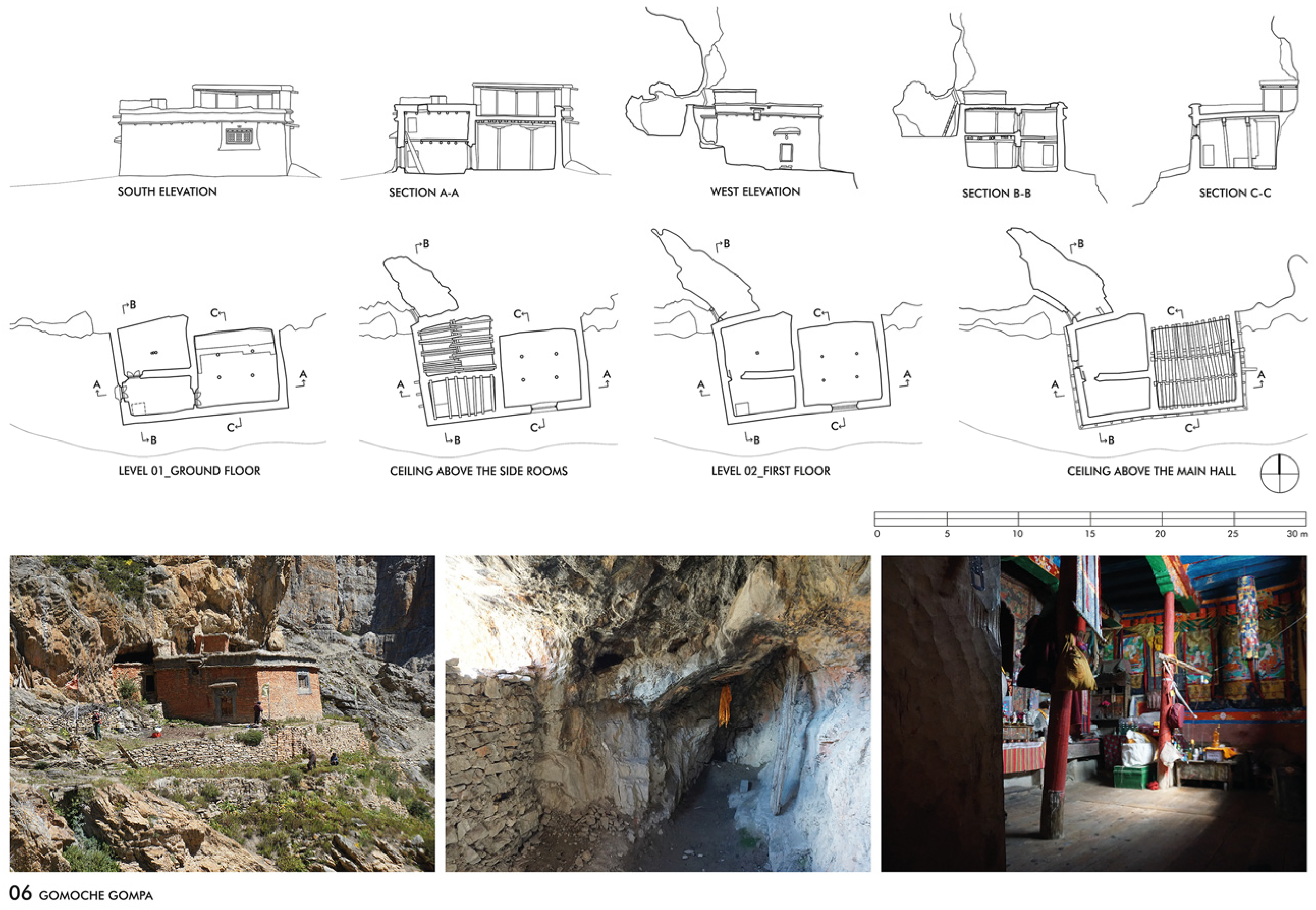
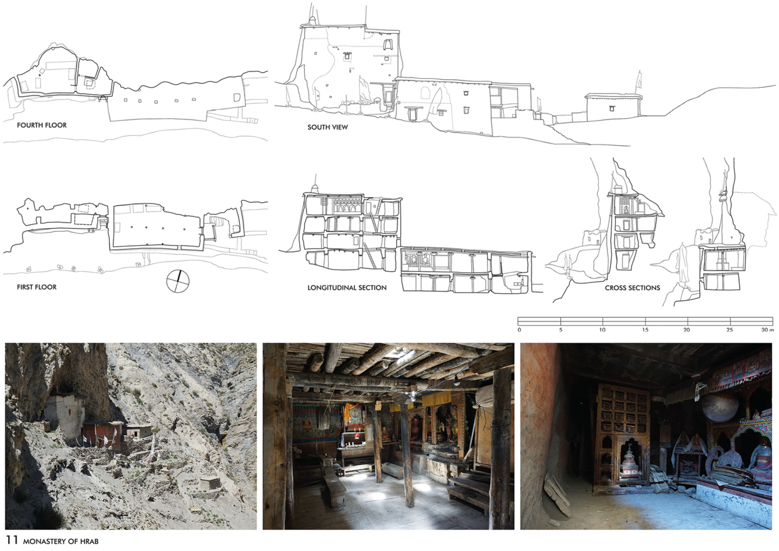
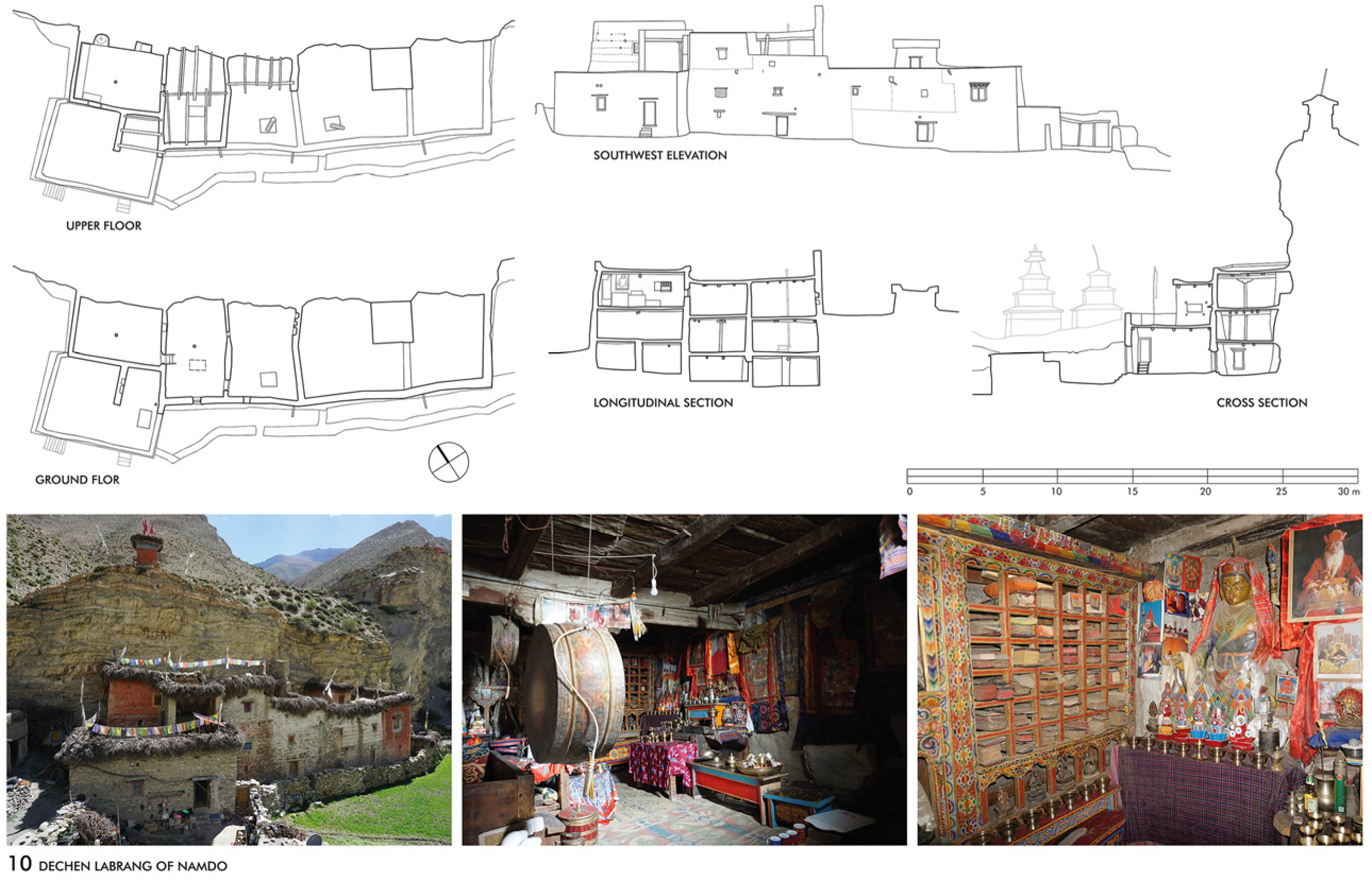
A unique architectural concept has been developed in locations of significant historical and cultural importance, which function as hermitages, providing monks with a place to retreat and engage in religious training. Three of these ensembles are located in remote areas and are difficult to reach. They are all associated with sacred places and caves that were considered suitable for retreating. The Gomoche Gompa (N° 06) and the Tsakhang Gompa (N° 05) of the Cristal Mountain site belongs to this type of structure as well as the Hrab Monastery (N° 11) and the Dechen Labrang of Namdo (N° 10), both situated in the Nangkhong valley (Figure 22).

3.7.1. Case Study No. 4: The Gomoche Gompa and the Tsakhang Gompa

The Gomoche Gompa (N° 06), with its minimal room configuration and the spacious cave in the rockface behind it, is a paradigm of this type of architecture. The site was first mentioned as the Vajra Cave of Shey, a name that clearly refers to a cave hermitage used for retreats—a tradition that continues to this day. Accordingly, the cave was the initial part of the ensemble, which was later erected in front of a rock and situated on a small terrace facing south. In addition to the cave, the ensemble comprises a partially two-storey building which is directly connected to the rock face on its northern side. In front of the gompa, the view opens out across the south-eastern river valley. The external dimensions of the building are 11.56 m by 6.52 m, with a height of 4.65 m to the flat roof of the higher part. It houses the anteroom and a storeroom on the ground floor and a kitchen and a sleeping room above. The entrance is on the west side, as the terrace is so narrow that it was impossible to organise it another way. From the anteroom, one can access an almost square assembly hall, measuring 5.55 m by 5.44 m, with a 3.46 m-high wooden ceiling supported by four pillars. A window on the south side illuminates the room, while an altar with a collection of books and sculptures stands on the north side. The entrance to the cave can be recognised from the forecourt on the west side of the gompa, consisting of an opening in a brick wall in front of the rock face to the northwest of the building. A few steps lead to the 3.3-m-wide outer wall, behind which lies the cave at approximately the same level as the upper floor of the gompa. The spacious inside is 9.00 m long, 2.80 m deep at its widest point and up to 4.00 m high. Immediately to the right of the interior, a ladder leads to the roof of the gompa through another opening in the wall (Figure 23).
Located just a few kilometres west of the Gomoche Gompa, the Tsakhang Gompa (N° 05) was also originally established as a cave hermitage for solitary retreat. The complex is impressively situated and widely visible on the high terraces in front of a steep red rock face on the north side overlooking the valley to the south, just like the Gomoche Gompa. Over time, the site later became a place of religious activity and meditation practice. The cave of this site is also located on the west side of the ensemble and encloses a sacred spring. Next to it, the terraced terrain in front of the rock face provides space for two buildings: the three-storey, whitewashed residential building and–slightly higher on the east side–the three-storey, red painted gompa. The interior of the gompa, with its nested rooms and floors, suggests that it was built in several phases. On the upper floor, an assembly hall is lit by a window with a balcony. The interior is narrow; an altar flanked by bookshelves covers the northern wall, and a wooden pillar in the middle of the room supports the ceiling. Another private chapel is located on the first floor of the residential building. The building phases, dimensions and extension of the monastery reflect the development of the users’ space requirements. Only in recent years have some smaller structures been added to the terrace in front of the gompa as part of a renovation programme. A precise building survey is still pending (Figure 24).

3.7.2. Case Study No. 5: The Hrab Monastery and the Dechen Labrang of Namdo

The impressive ensemble of Hrab (N° 11) is located on the northern ridge of the Nangkhong Valley, opposite the village of Tsa. It consists of two buildings set against the steep rock face: the red painted gompa is on the east side of the complex and has two floors, and the whitewashed building directly adjoining to the west has four floors. Both structures were built directly in front of the steep rock formation facing south towards the gorge, through which the path leads upwards. The total length of both structures is 27.17 m. A kitchen was built next to the courtyard to the gompa on the east side, while the ruins of a smaller residential building can be found on the west side. The assembly hall of the gompa is on the first floor and can be accessed via a wooden-roofed staircase from a small courtyard on the east side. This means that you enter the room on its narrow side, which is quite unusual. As seen from here, the hall is 10.15 m deep, 3.41 m wide on the east side and 2.20 m high. The main sculptures stand on their pedestals in the rear, north side of the room, where a cave-like niche in the rock extends the room to a width of 4.78 m. A row of four pillars along the longitudinal axis supports the ceiling. A small window in the southern facade and a row of roof openings light up the room. Traces in the masonry and an analysis of the floor plan show that the former entrance was on the opposite west side of the gompa and that the assembly hall was later extended on its east side, which resulted in the unusually elongated floor plan. The width of the altar niche on the north side previously limited the depth of the hall to about six metres.
The cave-like niche was once again decisive for the spatial configuration of the gompa—the development and construction of which was determined by the narrow terraces of the building site. The structure of the residential building also conceals a cave, which is a defining feature of the architecture. Next to the stables, storage rooms and living quarters, a four-storey building houses an amazing private chapel on the top floor which merges directly into the bordering cave at its rear side. This room is 3.85 m wide along the front and up to 4.75 m deep, with an area of around 20 m2. At the entrance, it is 2.28 m high, but the height of the grown rock on the north side of the room is reduced to less than half a metre. A sparse light from an opening in the ceiling and a small window on the south facade illuminates the room, creating an impressive atmosphere (Figure 25).
The similarities between the Tsakhang and the Hrab monasteries are striking: both are characterised by their multi-storey structure and the fact that they are built in areas with limited space and difficult access. In both cases, the separate residential buildings on the west side of the ensembles reflect a larger monastic community in which the residential buildings take on a representative character. The construction of several storeys is facilitated by the fact that the building actually ‘leans’ against the rock. The orientation to the south or southwest in front of massive stone formations is also significant from a building biology point of view. The rock face in the background not only provides shelter but also acts as a thermal mass, which is particularly pleasant in the cold winter months.
Other structures, such as the Dechen Labrang of Namdo (N° 10), have a different history, even if certain elements are repeated. This ensemble is located only a few kilometres northwest of Hrab, at the confluence of two rivers in a wide valley floor surrounded by fields. It was built directly in front of a striking, steep rock formation facing southwest. The north-western part of the structure, which was subject to detailed survey, comprises three storeys, with the assembly hall situated on the upper floor. The south-eastern part, which is directly attached, comprises two storeys. Together these parts have a total length of 27.59 m. In order to reach the assembly hall, it is necessary to cross the private rooms and proceed to a small courtyard situated in front of the anteroom of the hall. The assembly hall, at 21.30 m2, is relatively small and is 3.77 m wide, 5.60 m long and has a room height of 2.27 m. The entire ceiling is supported by a pillar in the middle of the room. The altar on the north-east side of the room is again placed directly in front of the rock face, where two cave-like niches with figures are integral parts. Traces on the north-west facade suggest that the original entrance was on this side—or possibly on the front facade, which is now hidden by the single-storey kitchen extension. Although it is clear from the history of the building that this was never a monastery, instead the residence of a lama, there are similarities both in the dimensions of the ensembles and in the size and conception of the halls—if one disregards the later extension of the assembly hall in Hrab (Figure 26).

4. Discussion

The buildings, which are documented in detail, represent different religious impulse centres that have developed through the centuries. The earliest sites can be dated back between the 11th and 13th centuries and has preserved in the Nangkhong Valley in Upper Dolpo. In the 13th century, another centre not far away from Bijer and Samling, developed around the Crystal Mountain, where famous hermitage sites were established, but the temple preserved here were later constructed, between the 16th and 17th centuries. Further south, in the Tarap Valley, representative temples were founded from the 15th century onwards. From the 17th century onwards, further Bon temples were also established here and later in the Phoksundo region in Lower Dolpo. The locations of the buildings are often spectacular and undoubtedly carefully chosen. The choice of the sites follows general references, the stability of the building site, the availability of water and sunlight are undoubtedly decisive factors. Limitations are due to geographical factors, such as the topography of the valleys and their course, and the position and height of the mountain ranges, which is the main reason for the deviation from the ideal eastward orientation.
The analysed inventory can essentially be divided into three building types. Firstly, the larger temples that are structured by six pillars in their assembly halls, named six pillar and nine beams temples. This type includes five of the temples we documented. The analyses showed that the earlier temples of this type in Bijer and Tokyu were originally single storeyed, while the later temples were constructed as two-storey structures. Secondly, there are smaller temples with a main hall structured by four pillars, named four pillar and eight beams temples. This type includes eight of the temples we documented. Each of these temples is two-storeyed, but the analyses showed only at the Bon temples the two-storey structure is part of the original concept. At the other temples, the investigation showed that they were originally designed as single-storey buildings and that the upper floor was added later. Thirdly, there are the overbuilt cave sanctuaries and multi-storey room structures. This type includes four ensembles. They all were erected in front of steep rock, facing south or southwest. The development of these two- to four-storey structures is facilitated by the fact that the building actually ‘leans’ against the rock.
The state of preservation of the buildings varies considerably. To gain a fundamental understanding of the structures that have developed over time, it is necessary to understand the structural changes and construction phases, which are examined in detail in five case studies of selected examples of the three different building types. Examination of the construction shows that all temples consist of solid stone walls with clay mortar and clay plaster, as well as wooden components used for pillars, beams, the ceilings, and windows and doors. Walls made of rammed earth or adobe bricks only were only used for repairs or later additions. The temples in Upper Dolpo feature the classic designs of the Tibetan highlands, with massive walls made of stone and clay and flat roofs, which were originally single-storey. In Lower Dolpo, wooden tie rods were additionally incorporated into the masonry to enable stable multi-storey construction. The roofs are covered with a timber construction with flat pitched roofs. Using this construction technique from Lower Dolpo for necessary renovations in Upper Dolpo is preferable to installing tin roofs on top of the existing flat roofs, as this would significantly alter the traditional appearance.
Cooperation with experts in geodetic methods opens the possibility of developing innovative methods in data collection, evaluation and presentation. It is out of question that digital building recordings and interactive visualisations open up new possibilities. But the cultural and media consequences of the digital turn are largely unexplored. In this regard, the following questions are relevant: how is the view of monuments and cultural heritage changing as a result of digital technologies? Does the prospect of a digital ‘rescue’ of endangered monuments lead to a second devaluation of the monument? Where is the boundary between a democratisation of knowledge and a narrowing to commercial or even political interests?
In recent years, serious discussions have begun about the responsibilities and benefits of research, both within the local community and among the academics involved [26]. The criticism that scientific publications would encourage art theft and the illegal art trade is countered by the argument that the creation of accurate documentation of the collections–especially with regard to the sculpture and tanka collection–strengthens the claims of the communities in the case of theft. As far as it is known, there are currently almost no inventory lists of the collections for the monasteries in Dolpo that would support the recovery of art objects in the case of theft. Even during our stay in 2023, there were robberies in some monasteries (Namdo and Tsakhang), and our work helped to return the stolen items back to Namdo. In any case, it is important to handle the subject sensitively and only publish photos of the artefacts in consultation with those responsible.
Nevertheless, it is obvious that the formal conditions for research in Nepal are becoming more difficult. In the future, a research permit from the government or the national park administration will be required for surveying work in this area. The autonomous freedom of decision of the monastery and temple members is undermined by the increased presence of police and military. These bureaucratic restrictions are understandable in some areas but nonetheless make it more difficult to plan and carry out field research, which is already difficult to implement in this region.

5. Conclusions

Although the preservation of cultural heritage is essential for the region, both for the identity of its own culture and tourism, there is little support from the government for all the challenges it faces, such as social changes, the lack of financial resources, inappropriate restorations, natural disasters and climate change. The earthquake in Nepal on 25 April 2015, dramatically showed how the lack of architectural documentation negatively affects restoration efforts. At a local level, direct contact with the people in charge enables us to support individual projects with our expertise and, if possible, to find sponsors for renovations. In this regard, detailed building documentation is a prerequisite for developing measures for future renovations. Therefore, the results of our architectural research must be made available as soon as possible, and digital media is particularly well suited to this purpose. Digital platforms allow for continuous updates throughout the course of an ongoing project, as demonstrated through our project website. On the one hand, this approach can increase the public perception and visibility of cultural heritage; on the other, it facilitates the sharing of results and documentation.
Most importantly, it is essential to recognise that preserving these buildings is crucial for sustaining the local religious rituals associated with them. We therefore hope that our research results will continue to support the preservation of the cultural heritage of Dolpo.

Supplementary Materials

The following supporting information can be downloaded at https://archresearch.tugraz.at/, accessed on 10 August 2025, Comprehensive material on the current and previous projects on Buddhist architecture in the Western Himalayas. The 3D-based survey data, in the form of eleven down-sampled 3D models of the digital survey in 2022 and 2023, is available on the repository of the Graz University of Technology under the search term ‘Dolpo’ (https://repository.tugraz.at/, accessed on 10 August 2025).

Funding

This research was funded in whole by the Austrian Science Fund (FWF) under the Grant-DOI 10.55776/P30685 and 10.55776/P35897. For open access purposes, the author has applied a CC BY public copyright licence to any author-accepted manuscript version arising from this submission.

Data Availability Statement

The data that support the findings of this study are openly available in the TU Graz Repository, by example, the 3D Model of the Nesar Gompa of Bijer (Bauer, P. and H. Woschitz) at https://doi.org/10.3217/jknbg-tzq09. More detailed data that support the findings of this study are available from the corresponding author, upon reasonable request.

Acknowledgments

This research would not have been possible without the benevolent support of many colleagues and the local authorities and residents of Dolpo, who have given us access to the buildings and who are doing their best to ensure the preservation of their cultural heritage. Special thanks go to Holger Neuwirth, Amy Heller, Helmut Woschitz, Peter Bauer, Vera Schabbon, Tashi Bhuti Lama, Lama Tenzin Gyaltsen, Lama Sherab Tenzin, Lama Namgyal, Lama Tinley, Tsering Lazom and Jigmey Lodey for all their support and encouragement. Open Access Funding by the Graz University of Technology.

Conflicts of Interest

The author declares no conflicts of interest.

References

  1. Jest, C. Dolpo. Communautés de Langue Tibétaine du Nepal; Editions du CNRS: Paris, France, 1975; p. 38. [Google Scholar]
  2. Jest, C. Preface. In Hidden Treasures of the Himalayas. Tibetan Manuscripts, Paintings and Sculptures of Dolpo; Heller, A., Ed.; Serindia Publications: Chicago, IL, USA, 2009; p. 12. [Google Scholar]
  3. Jackson, D.P. Notes on the History of Serib, and Nearby Places in the Upper Kali Gandaki Valley. Kailash 1978, 6/3, 195–228. [Google Scholar]
  4. Snellgrove, D.L. Himalayan Pilgrimage: A Study of Tibetan Religion by a Traveler Through Western Nepal; Bruno Cassirer: Oxford, UK, 1961. [Google Scholar]
  5. Snellgrove, D.L. Four Lamas of Dolpo: Tibetan Biographies. Introduction and Translation; Harvard University Press: Cambridge, MA, USA, 1967; Volume 1, pp. 2–3, 7–10. [Google Scholar]
  6. Kind, M. The Bon Landscape of Dolpo: Pilgrimages, Monasteries, Biographies and the Emergence of Bon; Peter Lang: Berlin, Germany, 2012. [Google Scholar]
  7. Tucci, G. Preliminary Report on Two Scientific Expeditions in Nepal; Serie Orientale Roma; Is.M.E.O.: Rome, Italy, 1956; Volume X. [Google Scholar]
  8. Snellgrove, D.L. The Nine Ways of Bon: Excerpts from gZi-brjid; Oxford University Press: London, UK, 1967. [Google Scholar]
  9. Jest, C. Monuments of Northern Nepal; United Nations Educational, Scientific and Cultural Organisation: Paris, France, 1981. [Google Scholar]
  10. NGMCP. Available online: https://www.aai.uni-hamburg.de/en/forschung/ngmcp/about.html (accessed on 27 August 2025).
  11. Heller, A. Hidden Treasures of the Himalayas: Tibetan Manuscripts, Paintings and Sculptures of Dolpo; Serindia Publications: Chicago, IL, USA, 2009. [Google Scholar]
  12. TMPV. Available online: https://tmpv.univie.ac.at/about (accessed on 27 August 2025).
  13. Kind, M. Mendrub—A Bo¨npo Ritual for the Benefit of All Living Beings and the Empowerment of Medicine Performed in Tsho, Dolpo; WWF-Nepal Program: Kathmandu, Nepal, 2002. [Google Scholar]
  14. Gansach, A. Social Constructions: A Comparative Study of Architectures in the High Himalaya of North West Nepal. Ph.D. Thesis, Architectural Association School of Architecture, London, UK, 30 June 1999. [Google Scholar]
  15. Gansach, A. Expressions of Diversity. A Comparative Study of Descriptions of Village Space in Ritual Processions in Three Villages of North West Nepal. In Sacred Landscape of the Himalaya; Proceedings of an International Conference at Heidelberg, Heidelberg, Germany, 25–27 May 1998; Gutschow, N., Michaels, A., Ramble, C., Steinkellner, E., Eds.; Austrian Academy of Science Press: Vienna, Austria, 2003; pp. 39–54. [Google Scholar]
  16. Gutschow, N. Chörten in Nepal. Architecture and Buddhist Votive Practice in the Himalaya; Dom Publishers: Berlin, Germany, 2021; pp. 401–426. [Google Scholar]
  17. Bauer, P.; Woschitz, H. Anwendung von 3D Laserscanning im Himalaya–Erste Auswertungen. VGI Österr. Z. Vermess. Und Geoinf. 2023, 111, 119–127. [Google Scholar]
  18. Bauer, P.; Woschitz, H. Laboratory Investigations of the Leica RTC360 Laser Scanner Distance Measuring Performance. Sensors 2024, 12, 3742. [Google Scholar] [CrossRef]
  19. Auer, C. Measure for Measure: Researching and Documenting Early Buddhist Architecture in Spiti. In The Spiti Valley: Recovering the Past and Exploring the Present; Proceedings of the First International Conference on Spiti, Wolfson College, Oxford, UK, 6–7 May 2016; Revue d’Études Tibétaines No. 41; Laurent, Y., Pritzker, D., Eds.; CNRS (CRCAO): Paris, France, 2017; pp. 181–201. Available online: https://d1i1jdw69xsqx0.cloudfront.net/digitalhimalaya/collections/journals/ret/pdf/ret_41.pdf (accessed on 10 August 2025).
  20. Mathes, K.D. Establishing the Succession of the Sakya Lamas of Näsar Gompa and Lang Gompa in Dolpo (Nepal). Wien. Z. Die Kunde Südasiens 2003, 47, 85–108. [Google Scholar] [CrossRef]
  21. Mathes, K.D. The Sacred Crystal Mountain in Dolpo: Beliefs and Pure Visions of Himalayan Pilgrims and Yogis. J. Nepal Res. Cent. 1999, 11, 61–90. [Google Scholar]
  22. Tucci, G. Geheimnis des Mandala. Theorie und Praxis; Otto Wilhelm Barth Verlag: Munich, Germany, 1972; pp. 28–29. [Google Scholar]
  23. Jackson, D.P.; Thubten, L.G. Gateway to the Temple: Manual of Tibetan Monastic Customs, Art, Building and Celebrations; Ratna Pustak Bhandar: Kathmandu, Nepal, 1979. [Google Scholar]
  24. Neuwirth, H.; Auer, C. (Eds.) The Ancient Monastic Complexes of Tholing, Nyarma and Tabo, Buddhist Architecture in the Western Himalayas; Verlag der Technischen Universität Graz: Graz, Austria, 2021; Volume 3, pp. 247–259. [Google Scholar] [CrossRef]
  25. Neuwirth, H.; Auer, C. (Eds.) The Ancient Monastic Complex of Dangkhar, Buddhist Architecture in the Western Himalayas; Verlag der Technischen Universität Graz: Graz, Austria, 2013; Volume 1, pp. 283–299. [Google Scholar] [CrossRef]
  26. Ramble, C. Is Cancel Culture Coming to Himalayan Studies? Remarks on a Recent Critique of the Life and Work of Mary Shepherd Slusser. Eur. Bull. Himal. Res. 2023, 61, 1839. [Google Scholar] [CrossRef]
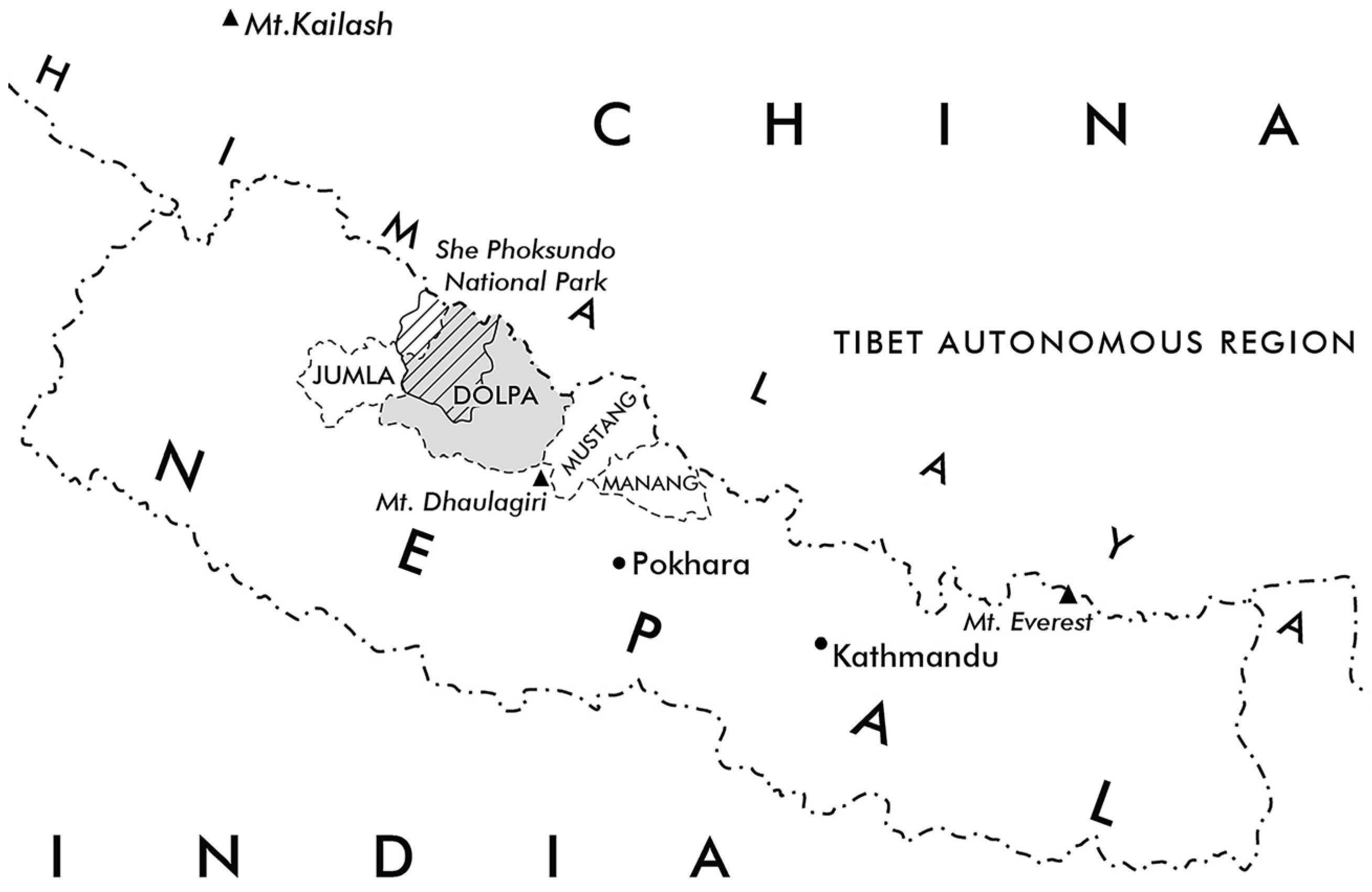
Figure 1. This map illustrates the geographical location of the research area and the bordering regions of the Western Himalayas. Dolpo, often also referred to as Dolpa, is highlighted in grey, with the cross-hatched area marking the territory of the national park.
Heritage 08 00385 g001
Figure 2. Map of the research area and of the surveyed sites in Dolpo.
Heritage 08 00385 g002
Figure 3. Measurement configuration with the RTC360 and TS11: the 3D model of the Nesar Gompa in Bijer show the used instruments, the polygon path (red line) of the reference system and the locations of the camera and scan (white marker) used for the 2022 survey.
Heritage 08 00385 g003
Figure 4. Examples of the digital measurements: different views of the 3D point cloud of the Ribo Bhumpa Gompa (N° 17), based on the survey in 2023.
Heritage 08 00385 g004
Figure 5. The 3D models of the Monastery of Shey (left), the Monastery of Samling (middle) and the Nesar Gompa in Bijer (right), show not only the main buildings but also the surrounding structures.
Heritage 08 00385 g005
Figure 6. Eighteen temples and monasteries were surveyed in Dolpo during four field campaigns between 2018 and 2023.
Heritage 08 00385 g006
Figure 7. The site plans of the ensembles show how the orientation and organisation of the entire complexes are determined by topographical features and the surrounding areas.
Heritage 08 00385 g007
Figure 8. The site plans of the ensembles also illustrate the different dimensions and spatial relationships between their structures and the surrounding space like the orientation of the temple’s main axis and the entrances.
Heritage 08 00385 g008
Figure 9. Examples of temples and monasteries located on exceptional places: mountains or terraces overlooking a lake or a river junction, close to sacred cliffs, springs and caves.
Heritage 08 00385 g009
Figure 10. Overview of the ‘Six Pillar and Nine Beams’ temples of Dolpo. The plans illustrate the various sizes, spatial concepts and constructional features of these temples, as well as any structural changes resulting from different construction phases over time.
Heritage 08 00385 g010
Figure 11. Floor plan, ceiling plan and pictures of the assembly hall in the Nesar Gompa (N° 07). The ceiling in the rear part of the hall, near the sanctuary, with its wooden carvings, such as lion consoles and Garudas, shows traces of different building phases.
Heritage 08 00385 g011
Figure 12. Comparisons of building type, dimensions and spatial concepts. The floor plan of the Nesar Gompa next to floor plans of reference buildings in Northern India with circumambulation around the sanctum, including the Golden Temple of Lalung/Spiti, the Main Temples of Tabo/Spiti and Nyarma/Ladakh.
Heritage 08 00385 g012
Figure 13. Building phases 1–4 of the Nesar Gompa in Bijer (N° 07). The southwest views (1a,2a,3a,4a) and longitudinal sections (1b,2b,3b,4b) of the spatial model illustrate the structural changes to the temple. Initially a single-storey building with a small assembly hall (building phase 1), the hall was first reconstructed (building phase 2), and later the entire structure was extended with a half storey (building phase 3) until finally being extended with an upper storey (building phase 4).
Heritage 08 00385 g013
Figure 14. Floor plans, ceiling plans, elevation, and sections of the Jampa Lakhang of Tokyu (N° 12). The pictures below show the interior on the ground floor and on the upper floor.
Heritage 08 00385 g014
Figure 15. Building phases 1–3 of the Jampa Lakhang of Tokyu/Dolpo (N° 12). The upper three rows show the development of the structure, which, as a former single-storey building (building phase 1 (1a1c)), changed its appearance and spatial programme through extensions (building phase 2 and 3 (2a3c)). As shown below, other buildings from different periods have a similar room concept. For example, the Dukhang in Alchi/Ladakh (on the left), the temple in Sumda Chung/Ladakh (in the middle) and the Red Temple of Tholing/Western Tibet (on the right).
Heritage 08 00385 g015
Figure 16. Remains of the Trangmar Gompa (N° 14). The floor plan, section and elevation show the remains in 2023, next to the reconstruction of the former shape. The pictures below show the preserved structure in 2018 and during the demolishment of the structure in 2023.
Heritage 08 00385 g016
Figure 17. Floor plans, ceiling plan, elevation, and sections of the Shey Monastery (N° 04), showing the structure of the temple. The pictures below show the interior on the ground floor and the courtyard on the first floor.
Heritage 08 00385 g017
Figure 18. Overview of the Bon temples of Dolpo. Examples of the plan documentation show some floor plans, sections and elevations of the different temples, which all belong to the group of the ‘Four Pillar and Eight Beams’ temples. They are all of similar dimension and show that the two-storey structure was already part of an established overall concept.
Heritage 08 00385 g018
Figure 19. The floor plans, sections and a view of the Kagar Labrang (N° 13), showing the structural changes of the former free-standing single-storey structure. The pictures below show the portal and the interior of the assembly hall on the ground floor and the room above with the entrance to a small chapel.
Heritage 08 00385 g019
Figure 20. The monasteries of Ringmo/Tsho (N° 01), Pugmo (N° 02) and Pumer: the floor plans and sections show the structure of the temples and how the light is directed from the upper floor down to the ground floor via a wall opening in the facade to a ceiling opening down into the assembly room. The pictures below show the different lanterns on the first floor of the gompas.
Heritage 08 00385 g020
Figure 21. The monasteries of Samling (N° 08) and Shipchok (N° 18): The Floor plans and sections show how the light is directed from the upper floor through a small courtyard in Samling, or through window shafts down into the assembly hall in Shipchok.
Heritage 08 00385 g021
Figure 22. Overview of floor plans, sections and views of the multi-storey structures in Dolpo, which were built in front of steep rock faces.
Heritage 08 00385 g022
Figure 23. Floor plans, sections and pictures of the Gomoche Gompa (N° 06).
Heritage 08 00385 g023
Figure 24. Pictures of Tsakhang Gompa (N° 05), taken in 2018.
Heritage 08 00385 g024
Figure 25. Floor plans and sections of the Hrab monastery (N° 11). The pictures show the south facade, the assembly hall on the first floor and the chapel on the fourth floor.
Heritage 08 00385 g025
Figure 26. Floor plans and sections of the Dechen Labrang of Namdo (N° 10). The pictures show the southwest facade and the assembly hall on the second floor, which features a main niche in the rock face.
Heritage 08 00385 g026
Table 1. Overview of the temples and monasteries in Dolpo that have been surveyed and documented so far, along with their GPS coordinates and links to additional information and resources. None of the buildings have yet been recognised as cultural monuments by the government, and there is currently no inventory of cultural heritage sites in Dolpo.
NameGPS CoordinatesWebsite/Collected Material
https://archresearch.tugraz.at/
(accessed on 10 August 2025)
Repository/Spatial Model (Supplementary Materials)
https://repository.tugraz.at/
(accessed on 10 August 2025)
01Monastery of Tsho/Ringmo29°10′30.21″ N, 82°56′39.09″ E,
altitude 3640 m
https://archresearch.tugraz.at/results/ringmo/
(accessed on 10 August 2025)
02Monastery of Pugmo 29°09′36.42″ N, 82°52′23.55″ E,
altitude 3245 m
https://archresearch.tugraz.at/results/pugmo/
(accessed on 10 August 2025)
03Monastery of Pumer29°09′05.30″ N, 82°51′49.76″ E,
altitude 3477 m
https://archresearch.tugraz.at/results/pumer/
(accessed on 10 August 2025)
04Shey Sumdo Monastery29°21′8.81″ N,
82°57′56.07″ E,
altitude 4345 m
https://archresearch.tugraz.at/results/shey/
(accessed on 10 August 2025)
https://repository.tugraz.at/records/sn49f-rj787
(accessed on 10 August 2025)
05Tsakhang Gompa29°22′1.38″ N,
82°57′18.42″ E,
altitude 4458 m
https://archresearch.tugraz.at/results/crystal-mountain/
(accessed on 10 August 2025)
06Gomoche Gompa29°22′1.38″ N,
82°57′18.42″ E,
altitude 4434 m
https://archresearch.tugraz.at/results/crystal-mountain_gomoche/
(accessed on 10 August 2025)
https://repository.tugraz.at/records/9gpxc-j0x43
(accessed on 10 August 2025)
07Nesar Gompa of Bijer29°27′8.06″ N,
82°54′51.36″ E,
altitude 3838 m
https://archresearch.tugraz.at/results/bijer/
(accessed on 10 August 2025)
https://repository.tugraz.at/records/jknbg-tzq09
(accessed on 10 August 2025)
08Samling Monastery29°25′52.59″ N, 82°54′27.44″ E,
altitude 4166 m
https://archresearch.tugraz.at/results/samling/
(accessed on 10 August 2025)
https://repository.tugraz.at/records/nf9kd-06793
(accessed on 10 August 2025)
09Yangtse Monastery29°29′45.00″ N,
83°5′54.77″ E,
altitude 3900 m
https://archresearch.tugraz.at/results/yangtser/
(accessed on 10 August 2025)


10Dechen Labrang of Namdo29°23′29.74″ N,
83°6′0.36″ E,
altitude 3950 m
https://archresearch.tugraz.at/results/namdo/
(accessed on 10 August 2025)
https://repository.tugraz.at/records/220bk-bn876
(accessed on 10 August 2025)
11Hrab Monastery29°22′30.61″ N,
83°7′8.28″ E,
altitude 4283 m
https://archresearch.tugraz.at/results/tsa/
(accessed on 10 August 2025)
https://repository.tugraz.at/records/hsfqx-qen16
(accessed on 10 August 2025)
12Jampa Lakhang of Tokyu29°9′52.38″ N,
83°9′31.08″ E,
altitude 4214 m
https://archresearch.tugraz.at/results/tokyu/
(accessed on 10 August 2025)
13Village Gompa of Kagar 29°9′0.86″ N, 83°10′16.83″ E,
altitude 4170 m
https://archresearch.tugraz.at/results/kagar-01/
(accessed on 10 August 2025)
https://repository.tugraz.at/records/eebzm-tyc06
(accessed on 10 August 2025)
14Trangmar Gompa of
Kagar
29°9′0.86″ N, 83°10′16.83″ E,
altitude 4170 m
https://archresearch.tugraz.at/results/kagar/
(accessed on 10 August 2025)
https://repository.tugraz.at/records/eebzm-tyc06
(accessed on 10 August 2025)
15Zur Gompa above Kagar29°9′7.43″ N, 83°10′19.39″ E,
altitude 4220 m
https://archresearch.tugraz.at/results/kagar-03/
(accessed on 10 August 2025)
https://repository.tugraz.at/records/eebzm-tyc06
(accessed on 10 August 2025)
16Mekyem Gompa29°8′49.04″ N, 83°10′55.77″ E,
altitude 4288 m
https://archresearch.tugraz.at/results/kagar-mekyem/
(accessed on 10 August 2025)
https://repository.tugraz.at/records/xvt6k-hr994
(accessed on 10 August 2025)
17The Ribo Bhumpa Gompa of Dho Tarap29°7′56.70″ N, 83°11′18.84″ E,
altitude 4069 m
https://archresearch.tugraz.at/results/dho-tarap/
(accessed on 10 August 2025)
https://repository.tugraz.at/records/r845a-2n560
(accessed on 10 August 2025)
18Shipchok Monastery of Dho Ro29°7′41.20″ N, 83°12′5.81″ E,
altitude 4146 m
https://archresearch.tugraz.at/results/dho-ro/
(accessed on 10 August 2025)
https://repository.tugraz.at/records/2422r-ske71
(accessed on 10 August 2025)
Disclaimer/Publisher’s Note: The statements, opinions and data contained in all publications are solely those of the individual author(s) and contributor(s) and not of MDPI and/or the editor(s). MDPI and/or the editor(s) disclaim responsibility for any injury to people or property resulting from any ideas, methods, instructions or products referred to in the content.