Article

Geotourism in Monogenetic Volcanoes: The Case of Tapias-Guacaica Monogenetic Volcanic Field in Colombia

by
Alejandro Arias-Díaz
1,2,3,
Erika Ibargüen-Angulo
4,
Hugo Murcia
1,3,*,
Susana Osorio-Ocampo
1,
Gina Bolaños-Cabrera
1,
Luis Alvaro Botero-Gómez
1,3,5 and
Ana Riascos-Hurtado
4
1
Grupo de Investigación en Estratigrafía y Vulcanología (GIEV) Cumanday, Universidad de Caldas, Manizales 170001, Colombia
2
Advanced Unit for Research on Regional Analysis (AURORA), Comunicación Científica SAS, Manizales 170001, Colombia
3
Instituto de Investigaciones en Estratigrafía (IIES), Universidad de Caldas, Manizales 170001, Colombia
4
Grupo de Gestión y Turismo, Universidad del Pacífico, Buenaventura 764501, Colombia
5
Ciencias–Geología, Universidad de Caldas, Manizales 170001, Colombia
*
Author to whom correspondence should be addressed.
Heritage 2025, 8(6), 185; https://doi.org/10.3390/heritage8060185
Submission received: 13 April 2025 / Revised: 7 May 2025 / Accepted: 7 May 2025 / Published: 24 May 2025
(This article belongs to the Section Geoheritage and Geo-Conservation)

Abstract

Geosciences today play a vital societal role beyond their traditional extractive functions, offering innovative approaches to disseminate knowledge that supports local problem solving and climate resilience. UNESCO Global Geoparks have emerged as strategic platforms for promoting sustainable geoscientific values such as geodiversity, geoeducation, geoconservation, and geoethics. Within the Volcán del Ruiz Geopark Project (VRGP), an effusive andesitic monogenetic volcanic field contains both volcanological and industrial geoheritage. Using Brilha’s evaluation framework, this study assessed eight volcanic features and one industrial site, identifying La Capilla volcano and the Cementos Caldas ruins as having the highest scientific, educational, and touristic value. A structured georoute was proposed, integrating interpretive strategies to enhance public engagement with geodiversity, spatial awareness, and volcanic processes. The success of such initiatives depends on active community participation and interinstitutional collaboration to ensure the appropriation and operationalization of geoscientific knowledge. The VRGP stands out as a promising territorial strategy for anchoring geoeducation and geotourism within broader sustainability and community empowerment goals.

1. Introduction

Geosciences have long played a foundational role in supporting the development of modern economies, particularly through the exploration of minerals, materials, and natural resources [1]. In addition to these economic contributions, geoscientific research has significantly advanced our understanding of Earth’s composition and geological evolution [2,3]. By documenting key events in Earth’s history, including the evolution of climate systems, biodiversity, continents, and oceans, geosciences offer critical insights into planetary processes [4]. Today, geoscientific knowledge underpins essential societal functions such as geohazard mitigation, climate risk management, energy security, and the global transition toward low-carbon systems [5,6,7].
At its core, geoscience focuses on observing, interpreting, and forecasting the natural systems that regulate and support the environmental conditions in which human activities occur [8,9,10]. Promoting and effectively communicating this knowledge is vital for empowering communities to adapt to the planetary climate crisis [11,12]. In this context, UNESCO Global Geoparks have emerged as international initiatives that integrate geoscientific innovation into sustainable territorial development strategies [13,14,15,16]. Through expanding networks such as the Global Geoparks Network (https://www.globalgeoparksnetwork.org/ (accessed on 5 April 2025)), these initiatives promote collaboration and apply foundational geoscientific principles (i.e., geodiversity, geoconservation, geoheritage, geoeducation, geoethics, and geotourism) to foster sustainability [17,18,19,20,21,22,23,24,25,26,27,28,29].
Among these principles, geotourism has become a core pillar of UNESCO Global Geoparks. It promotes the valorization of geological heritage through educational and recreational experiences designed for both experts and general audiences [17,19,30]. Geotourism is broadly defined as a form of sustainable tourism centered on the exploration of geological features, with a strong emphasis on conservation, environmental awareness, and cultural understanding [31,32,33]. By providing interpretive infrastructure and educational services, it fosters a deeper understanding of geological and geomorphological features, moving beyond aesthetic appreciation [34,35]. Recognized as an interdisciplinary applied science, geotourism integrates geological, environmental, and tourism knowledge to identify, develop, and conserve significant landscapes through sustainable planning [36]. Though often considered a contemporary practice, geotourism traces its roots to the exploratory journeys of geologists and scientists, historically driven by the search for natural resources or scientific discovery [37,38].
In line with these global trends, the present study focuses on a region in central Colombia that has been the subject of ongoing efforts to establish a UNESCO Global Geopark (Figure 1). This territory is anchored by the Nevado del Ruiz volcano, one of the most extensively studied volcanoes globally and included in the IUGS’s list of the first 100 geological heritage sites [39]. The volcano gained global prominence following the 1985 Armero tragedy, in which a lahar triggered by a small eruption claimed approximately 25,000 lives, catalyzing major advancements in volcanic risk management worldwide [40,41]. Within this broader geological and socio-environmental context, this manuscript examines the geoheritage significance of eight monogenetic volcanic features within the Tapias-Guacaica Monogenetic Volcanic Field (TGMVF), which lies within the perimeter proposed for the Volcán del Ruiz Geopark Project (VRGP) (Figure 1). The study also includes an assessment of industrial heritage ruins located among the volcanic features of the area. The field is situated in the department of Caldas, in the northern volcanic segment of central Colombia (Figure 1). Specifically, this research assesses the scientific significance, educational value, tourism potential, and degradation risk of the inventoried volcanological and industrial geoheritage/geodiversity sites, while highlighting the attributes that may be prioritized for sustainable geotourism within the TGMVF. Building on this assessment, the study also explores how the design of an interpretative georoute, integrating spatial awareness, local culture, and geological understanding, can foster public engagement, enhance geosciences divulgation, and support community-based geoconservation efforts.
The main objective of this work is to enhance environmental awareness and promote the socio-economic development of local communities through the diversification of tourism activities. While Colombia currently lacks officially designated UNESCO Global Geoparks, initiatives such as VRGP are actively participating in regional efforts, including engagement with the Latin American Geoparks Network (GeoLac). Within this context, and grounded in the geoheritage assessments conducted, this study advances strategic proposals for sustainable development of a geologically significant territory while also presenting a structured framework to support local stakeholders in advancing toward a formal UNESCO Global Geopark submission.

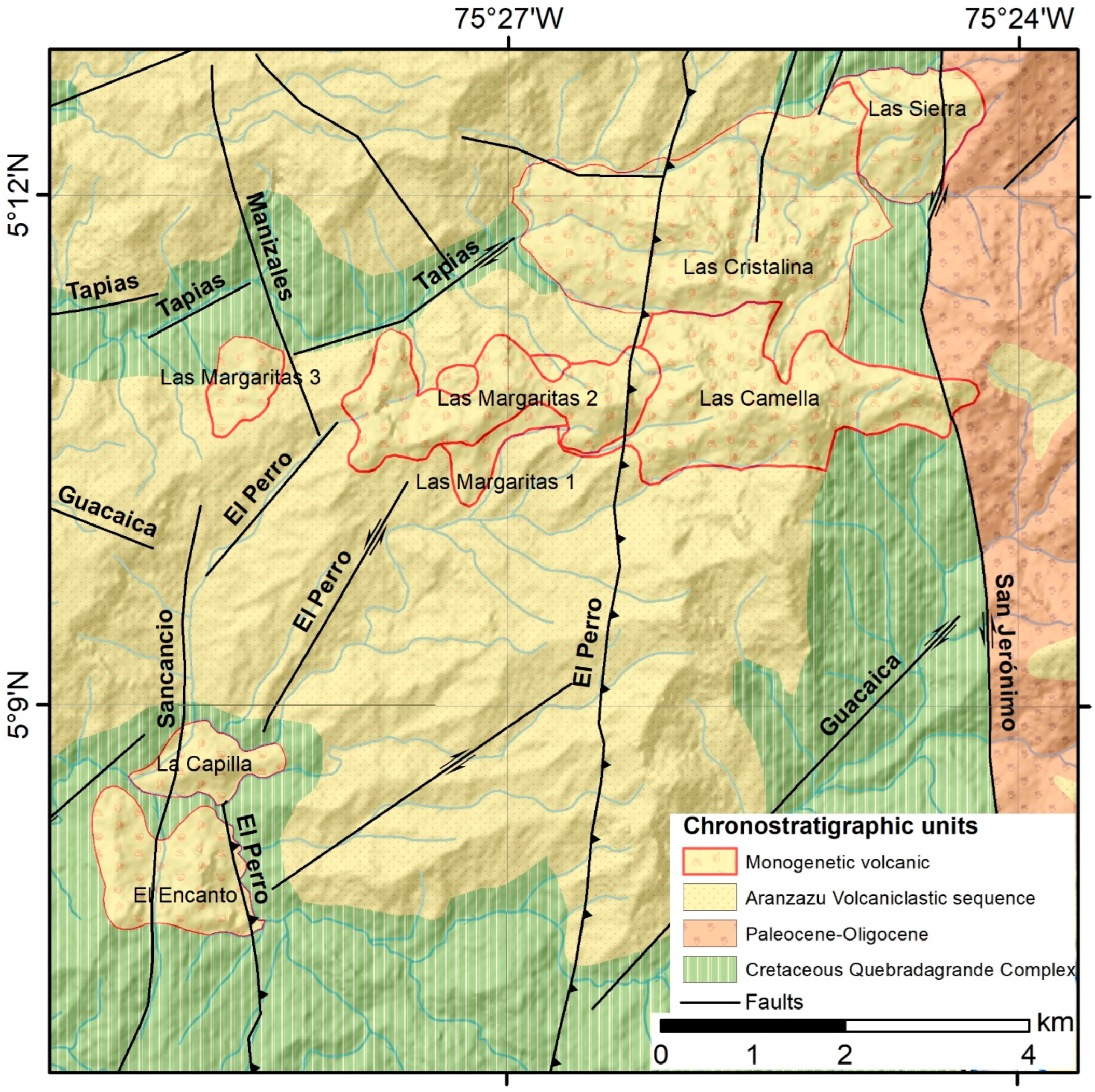
2. Geological Regional Context

Colombia, located on the northwestern edge of South America, is characterized by extensive volcanic regions primarily concentrated along the central axis of the Central Cordillera, within the Northern Volcanic Zone of the Andes. This zone spans Colombian territory through three major volcanic segments: northern, central, and southern [42,43]. This volcanic activity is predominantly driven by the subduction of the Nazca oceanic plate beneath the South American continental plate, a tectono-orogenic process responsible for the formation of both polygenetic and monogenetic volcanoes [44].
Within this framework, the Tapias-Guacaica Monogenetic Volcanic Field (TGMVF), located in the northern volcanic segment, comprises small volcanoes predominantly andesitic in composition [45]. These features are supplied by a stagnant crustal magma reservoir situated at depths between 20 and 30 km [46]. The magmatism, associated with arc-related subduction processes, has been active in the region from the Late Miocene to the Quaternary [47]. The emplacement of the TGMVF volcanoes is structurally controlled by extensional (dilatant) fault systems, and radiometric dating places their eruptive activity between approximately 1.4 and 0.8 million years ago [45].
The geological basement of the region is composed of the Cretaceous Quebradagrande Complex, which includes both volcanic and sedimentary lithologies [48,49,50]. This basement is intruded locally by Paleocene to Lower Eocene igneous bodies [47,51]. The volcanic member consists of basalts, andesites, spilites, and diabases, while the sedimentary member comprises carbonaceous mudstones, greywackes, feldspathic and lithic sandstones, siltstones, and limestones [52,53,54]. Volcaniclastic units (i.e., deposits made up of volcanic fragments that have been transported and deposited by various processes) are partially represented in the area by the Aranzazu Volcaniclastic Sequence, which has been recently defined and characterized in regional studies [47].
This basement is transected by the Romeral Fault System [49], a complex network of N–S to NNE-trending strike-slip faults that delineate boundaries between terranes of contrasting ages and geological histories [55]. These faults occur within anastomosed structural zones, characterized by the presence of mafic and ultramafic rocks, high-pressure metamorphic assemblages, and arc-related volcanic and sedimentary sequences [49,51,53]. The principal fault systems affecting the study area include the Manizales, Sancancio, El Perro, Guacaica, San Jerónimo, and Tapias faults (Figure 2). According to Botero-Gómez [56], these structures exhibit varying kinematics: the San Jerónimo, Manizales, and El Perro faults show sinistral reverse movement; the Guacaica and Tapias faults exhibit dextral strike-slip movement; and the Sancancio fault is characterized by normal faulting.

3. Regional Tourism Context

Colombia is a megadiverse country with extraordinary geographical, scenic, and sociocultural richness, making it an ideal destination for those interested in experiencing geological, ethnic, and natural heritage [57,59]. The department of Caldas, where the TGMVF is located, is renowned for its cultural and natural heritage, and the region has significant potential to promote sustainable local economies [60,61]. This potential is reinforced by regional initiatives aligned with UNESCO designations, such as the Colombian Coffee Cultural Landscape (PCCC) and the VRGP.
The PCCC exemplifies the harmonious integration of natural, economic, and cultural elements, reflecting the region’s adaptation to coffee cultivation on the steep slopes of the Central Cordillera (www.paisajeculturalcafetero.org.co; accessed on 11 April 2025). In parallel, the VRGP promotes regional integration through strategies focused on geoconservation, geoeducation, geotourism, and geoproducts, all aimed at sustainably managing the region’s geological, natural, and cultural heritage (www.geoparquevolcandelruiz.com; accessed on 11 April 2025). Previous assessments have identified the Nevado del Ruiz volcano as having strong potential to become a UNESCO Global Geopark [62]. Its conceptual framework has evolved through a growing body of academic and undergraduate research focused on the territory’s geological heritage [63,64,65,66,67,68,69,70], as well as its geodiversity [71]. To date, the Volcán del Ruiz Geopark project has officially launched two thematic georoutes: one focused on climate change, and the other on volcanic resilience. The first involves a high-altitude trek to the last glacial remnants of the Nevado Santa Isabel Volcano, Colombia’s next glacier expected to disappear [72,73]. The second follows a trans-Cordillera route that crosses the Los Nevados National Natural Park and leads to the ruins of Armero, site of the 1985 volcanic disaster.
The typologies of tourism products and activities in the region include nature-based tourism such as ecotourism (e.g., birdwatching, high-altitude hiking, mountaineering, and geotourism); rural and agrotourism (e.g., coffee estates, coffee tours, and “farmer for a day” experiences); and adventure tourism (e.g., tubing, rappelling, kayaking, canyoning, and rafting) [74]. Cultural tourism offerings include coffee culture experiences (e.g., traditional coffee towns and local gastronomy), festivals and events (e.g., the Manizales Fair and the Rio Sucio Carnival), and historical tourism (e.g., routes of colonization and mule-driving heritage). Sports tourism is also prominent, especially cycling (e.g., road biking, downhill, mountain biking, bikepacking, and gravel riding). Additionally, the region promotes wellness and health tourism (e.g., thermal spas and wellness centers), as well as corporate and MICE tourism (e.g., corporate events and business travel). Caldas offers a wide range of lodging options, with 731 registered establishments, along with 190 travel agencies and 165 certified tourism guides [74]. However, tourism development in Caldas still faces persistent challenges, including limited financial resources, poor connectivity with rural areas and the Manizales regional airport, and insufficient bilingual capacity to serve international visitors [75]. These limitations are compounded by periodic access restrictions resulting from the activity of the Nevado del Ruiz volcano, a geosite of international relevance within the VRGP framework [39].

4. Methods

This work applies the methodology proposed by Brilha (2016) [76], one of the most widely recognized frameworks for the assessment of geological heritage. The evaluation focuses on monogenetic volcanism and industrial heritage, following a structured approach based on scientific, educational, and touristic value, along with degradation risk, which helps define geoconservation priorities within the study area. Fieldwork and bibliographic research were conducted to characterize the monogenetic volcanic features, while the nearby industrial ruins, culturally significant and spatially linked to the volcanic components, were included for their potential to support and strengthen geotourism development in the region.
Each site was evaluated according to parameters defined for scientific, educational, touristic, and degradation risk criteria, with scores ranging from 0 (lowest) to 4 (highest). The scores were then weighted according to relative importance percentages, resulting in a total possible score ranging from 0 to 400 points (Table 1). Based on the final scores, the components were classified as having a low (i.e., <200), medium (i.e., 201–300), or high (i.e., >301) geoheritage value. Detailed descriptions of the method and parameters can be found in Brilha (2016) [76].

5. Results

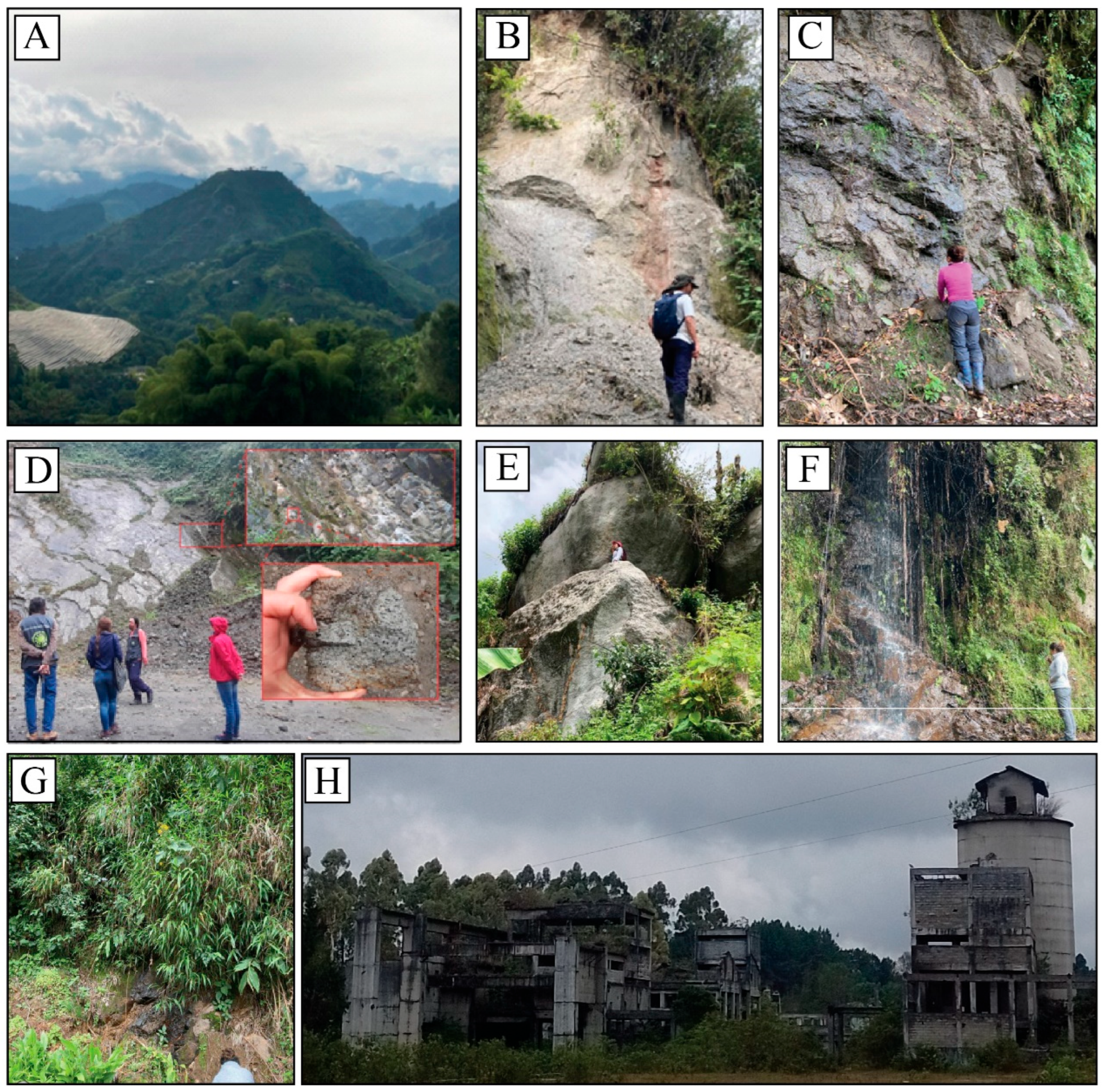
5.1. Geoheritage Inventory

Eight monogenetic volcanoes were considered for the TGMVF evaluation, including a lava dome, three lava flows, a coulée dome, and three volcanoes without a clear geoform. Additionally, an abandoned ruin, classified as industrial geoheritage, was included (Figure 3). The volcanoes feature mainly effusive bodies accompanied by some associated deposits created by lava dome collapses. The inventoried elements include the following:
(1) A lava dome called “La Capilla”, characterized by a well-defined conical geoform with an average height of 500 m (Figure 3A). Its rocks are porphyritic, with plagioclase crystals over 1 cm in size, and it exhibits columnar jointing structures from cooling at the base. This volcano has an age of 0.81 ± 0.04 Ma [77].
(2) A monogenetic volcano named “Las Margaritas 3”, which, although lacking a defined geoform, exposes porphyritic rocks composed of plagioclase, amphibole, and biotite crystals embedded in a groundmass of the same composition. This volcano is the only one in the TGMVF that features an associated pyroclastic density current deposit (block-and-ash flow) linked to its original geoform (Figure 3B). This volcano has an age of 1.29 ± 0.05 Ma [77].
(3) A coulée monogenetic volcano called “Las Margaritas 1”, standing 150 m tall with a basal diameter of ~1.8 km. It is composed of rocks containing plagioclase, amphibole, and biotite crystals, with occasional spheroidal weathering (Figure 3C). This volcano has an age of 0.77 ± 0.04 Ma [45].
(4) A lava flow-type monogenetic volcano named “Las Margaritas 2”, with a thickness of 10 to 20 m and an extension of ~3.3 km. Its rocks consist of plagioclase and amphibole, showing concentric fracturing due to thermal contraction and columnar jointing (Figure 3D). This volcano has an age of 0.8 ± 0.05 Ma [45].
(5) A lava flow-type volcano called “El Encanto”, extending 0.7 km along its longest axis, with porphyritic rocks containing plagioclase crystals over 1 cm in size. It is notable for having a natural cave, and columnar jointing is visible at its base (Figure 3E).
(6) A lava flow-type monogenetic volcano named “La Cristalina 1”, with a 2.5 km extension. Its partially weathered rock is composed of plagioclase, amphibole, and biotite, with fractures and significant vegetation cover, limiting the characterization of its associated geoform (Figure 3F).
(7) An eruptive center named “La Cristalina 2”, which stretches 2.8 km at its longest point. The volcano’s outcrop measures 8 m wide and 4 m high (Figure 3G).
(8) An effusive-type monogenetic volcano called “La Camella”, which lacks a defined morphology and shows a high degree of weathering. It extends approximately 1.5 km and is distinguished by having the most basic rock composition in the entire TGMVF, with porphyritic textures and crystals of plagioclase, amphibole, and pyroxene.
(9) The abandoned ruins of Cementos Caldas, which are linked to an old cement factory that exploited a lenticular limestone body, part of the lithological diversity of the region (Figure 3H).

5.2. Quantitative Assessment

5.2.1. Scientific Value

The scientific value assessment indicated that one volcano received a high score (>300), four volcanoes and the Cementos Caldas industrial ruins received medium scores (201–300), and three volcanoes received low scores (101–200) (Table 2). Among all evaluated sites, La Capilla is the only one to receive a high overall scientific rating, making it the most representative site (i.e., a geosite sensu stricto) for understanding monogenetic volcanism within the TGMVF (Figure 3A). While the scientific relevance of the TGMVF is generally considered regional, Las Margaritas 1, and Las Margaritas 2, in addition to La Capilla, were identified as geodiversity sites of local importance due to key features such as their exemplary morphology and the availability of published scientific research. In terms of geological integrity, La Capilla and El Encanto received the highest ratings due to their well-preserved geological features; both of them show columnar jointing structures in their base. Rarity scores across the TGMVF were generally low, though Cementos Caldas stands out due to the scarcity of comparable industrial heritage sites in Colombia. La Capilla is further distinguished as the only volcano in the field with a clearly defined dome morphology. Additional singular features include Las Margaritas 3, which contains the only pyroclastic density current deposit in the field; Las Margaritas 1, identified as the only coulee dome; and El Encanto, which features a cavern formed within its rocky structure. Most volcanoes are visible from a public road, which means few access limitations. However, certain restrictions exist due to agricultural activities on private lands, particularly around La Capilla and El Encanto, and due to the deteriorated condition of the Cementos Caldas ruins. Regarding scientific knowledge, Las Margaritas 1 and Las Margaritas 2 are the only volcanoes with peer-reviewed publications in indexed international journals (e.g., [45]). Additionally, La Capilla and Las Margaritas 3 have been the focus of bachelor’s theses and national academic presentations (e.g., [77]). The broader landscape of the TGMVF is characterized by heterogeneous topography, steep slopes, a network of active fault systems, a diverse range of igneous, metamorphic, and sedimentary rocks, soils primarily composed of Andisols, and abundant water resources [72]. This geodiversity contributes to the high overall rating valued within the monogenetic volcanic field.

5.2.2. Educational Value

The assessment of educational value revealed that only one volcano and the Cementos Caldas ruins received high scores, while six volcanoes were rated as medium, and one was rated low (Table 3). La Capilla and the Cementos Caldas ruins have the highest educational potential, as both are suitable for interpretation by diverse audiences. La Capilla, with its dome morphology, offers an excellent opportunity to explain the mechanism behind monogenetic eruptions in the region. Its geomorphological expression and visible evidences of magma emplacement processes make it ideal for discussions ranging from basic geological interpretation to more advanced volcanological concepts. Conversely, the Cementos Caldas ruins enable educational discussions about human-environment interactions and the historical reliance on geosystem services, illustrating the anthropogenic dimensions of geodiversity. While Las Margaritas and El Encanto also offer educational value, they generally require a more specialized audience due to the complexity or subtlety of their geological features. In terms of observation conditions, La Capilla and El Encanto provide clear views of key geological elements. In contrast, Las Margaritas and Cristalina suffer from visibility issues caused by dense vegetation, weathering, or poorly preserved volcanic morphology. In the vulnerability category, the Cementos Caldas ruins present the highest risk of degradation. The combination of increased visitor traffic and structural deterioration, exacerbated by vegetation overgrowth and weather exposure, places this industrial geoheritage at significant risk. La Capilla received the highest accessibility score, given its visibility from multiple roads and the presence of a direct access route leading to its base. Other volcanoes in the field are accessible via intermunicipal roads; however, road conditions limit access by larger vehicles, such as tour buses. Overall, safety infrastructure is limited across the TGMVF. There are no informational signs, barriers, or parking facilities at the volcanic features or ruins. Nevertheless, all assessed sites received high scores for their association with other values, due to the region’s rich cultural and biological diversity, which is of national and international significance and regularly attracts visitors. La Capilla also received the highest scenic value, with its imposing conical shape offering panoramic views from various vantage points within the field. Logistical qualifications, based on proximity to main roads and access to nearby restaurants or accommodations, were the highest for La Capilla, Las Margaritas 1 and 3, El Encanto, and the Cementos Caldas ruins. Population density scores were generally low, as the area has fewer than 100 inhabitants per square kilometer. Lastly, uniqueness was recognized in La Capilla for its well-defined dome shape; in Las Margaritas 3 for containing the only pyroclastic density currents in the field; in El Encanto for the presence of a small cave at its base; and the Cementos Caldas ruins for being the only industrial heritage site of its kind in the region.

5.2.3. Touristic Value

The assessment of touristic value within the TGMVF identified one volcano with a high rating, five volcanoes and the Cementos Caldas ruins with moderate ratings, and two volcanoes with low ratings (Table 4). The scoring and rationale for the parameters of vulnerability, accessibility, safety, association with other values, scenery, usage limitations, observation conditions, logistics, population density, and uniqueness were consistent with those determined in the educational and scientific value assessments. In terms of interpretative potential, La Capilla and the Cementos Caldas ruins received the highest scores. The geological features at both sites are clearly expressed and easily understandable by visitors without a specialized background, making them highly accessible to general audiences. At La Capilla, the distinct dome-shaped morphology allows people to visualize how monogenetic volcanoes form and how magma is emplaced beneath the surface, turning abstract volcanic processes into tangible landscape features. In contrast, the Cementos Caldas ruins provide a powerful reflection on society’s dependence on geodiversity. As a site once tied to mineral extraction, its current state of abandonment illustrates the socio-environmental risks that arise when provision-based geosystem services are exhausted, regardless of the sustainability model pursued. Conversely, the other monogenetic volcanoes in the field require prior knowledge of geology for visitors to fully grasp their geoheritage significance. The economic level of the region was generally rated as moderate to low, based on municipal per capita income data, which aligns closely with national averages. Regarding the proximity to recreational areas, La Capilla, El Encanto, and the Cementos Caldas ruins scored highest due to their closeness to rural coffee farms offering guided tours, nature-based experiences, and lodging options.

5.2.4. Degradation Risk

All assessed geoheritage elements in the TGMVF exhibit a moderate risk of degradation (Table 5). The deterioration of geological features in the area is mainly driven by human activities, including the intermunicipal road that cuts across the volcanic field and exposes several volcanoes along its route. While the road facilitates educational and touristic access, it also poses a threat to geological elements due to constant vehicular traffic. In addition, widespread agricultural and livestock activities impact soil quality and stability, triggering geomorphological processes such as soil creep and landslides. These processes can obscure and damage key geological features, limiting their visibility and interpretative potential. Overall, the TGMVF lacks formal heritage protection mechanisms; property ownership is predominantly private, and current land-use practices often conflict with geoconservation priorities.

6. Discussion

6.1. Geotourism Potential in the Tapias-Guacaica Monogenetic Volcanic Field

Following the geoheritage assessment conducted across the TGMVF, the La Capilla lava dome emerges as the only inventoried feature that qualifies as a geosite, under Brilha’s [76] strict definition, which reserves this designation for in situ geodiversity elements with verified and high scientific value. With its well-preserved morphology, internal structure, and clearly exposed geological features, La Capilla exemplifies effusive monogenetic volcanic processes. Its accessibility and interpretive clarity further enhance its value, highlighting its intrinsic geotouristic potential. In contrast, the remaining monogenetic volcanic features in the area did not meet the scientific threshold required for geosite designation and are, therefore, categorized as geodiversity sites. Meanwhile, the Cementos Caldas ruins, representing the industrial remnants of a former limestone mining operation, are classified as mining industrial heritage. Although they fall outside the geosite classification, they possess strong extrinsic geotouristic potential, particularly due to their cultural resonance and local interest among residents and visitors.
The distinction between geosites and geodiversity sites is significant. As outlined by Brilha [76], geosites represent the core of geological heritage and must be preserved fundamentally for their scientific importance, whereas geodiversity sites contribute to education, recreation, and tourism [76]. Nevertheless, for geoconservation and geotourism strategy development, the integrated management of both types of sites is essential to delivering engaging and sustainable visitors experiences.
La Capilla volcano can be classified as a viewpoint geosite in terms of [78], with accessible zones for direct observation of volcanic processes, and panoramic viewpoints showcasing its dome-shaped morphology in the Andean landscape of Colombia’s Central Cordillera. Comparable dome-shaped monogenetic volcanoes have been documented elsewhere in the VRGP territory, such as Sancancio dome and Amazonas dome, both part of the Villamaría-Termales Monogenetic Volcanic Field c.f. [79], and they have demonstrated successful incorporation into geotourism and geoeducation activities [80]. These geosites contribute not only to scientific understanding but also to public engagement, which is why their geoheritage conservation is vital [4], particularly when supported by interpretative materials that help broad audiences visualize volcanic processes within a scientifically established framework.
In parallel, the Cementos Caldas ruins offer a compelling narrative of industrial mining heritage shaped by the depletion of geosystem provisioning services. The exhaustion of a local limestone deposit led to the plant’s closure, providing a powerful narrative about resource dependency, environmental degradation, and broader sustainability issues. The site invites visitors to critically engage with the consequences of natural system decline and the social impacts of resource scarcity. The combination of La Capilla’s intrinsic geotouristic value and the extrinsic geotourism potential of Cementos Caldas makes both sites strong candidates for innovative geotourism strategies that diversify visitor experiences and promote sustainable territorial development.
Moreover, the territorial context of both sites significantly enhances their geotourism potential. Situated within the Coffee Cultural Landscape, a UNESCO-recognized Intangible Cultural Heritage of Humanity, these sites allow for the integration of geological interpretation with the history, culture, and traditions of local coffee-growing and mule-driving communities. Visitors can engage in immersive experiences including coffee farming tours, learning about agricultural practices, and participating in coffee preparation and tasting rituals. This geotourism offering is further strengthened by the region’s rich ecosystems, home to a diverse array of birds, plants, and flowers, as well as a well-developed service infrastructure. Nearby accommodations, restaurants, and transportation services support and enhance the interpretive experiences at La Capilla and Cementos Caldas, making them ideal anchors for meaningful and dynamic geotourism learning opportunities.

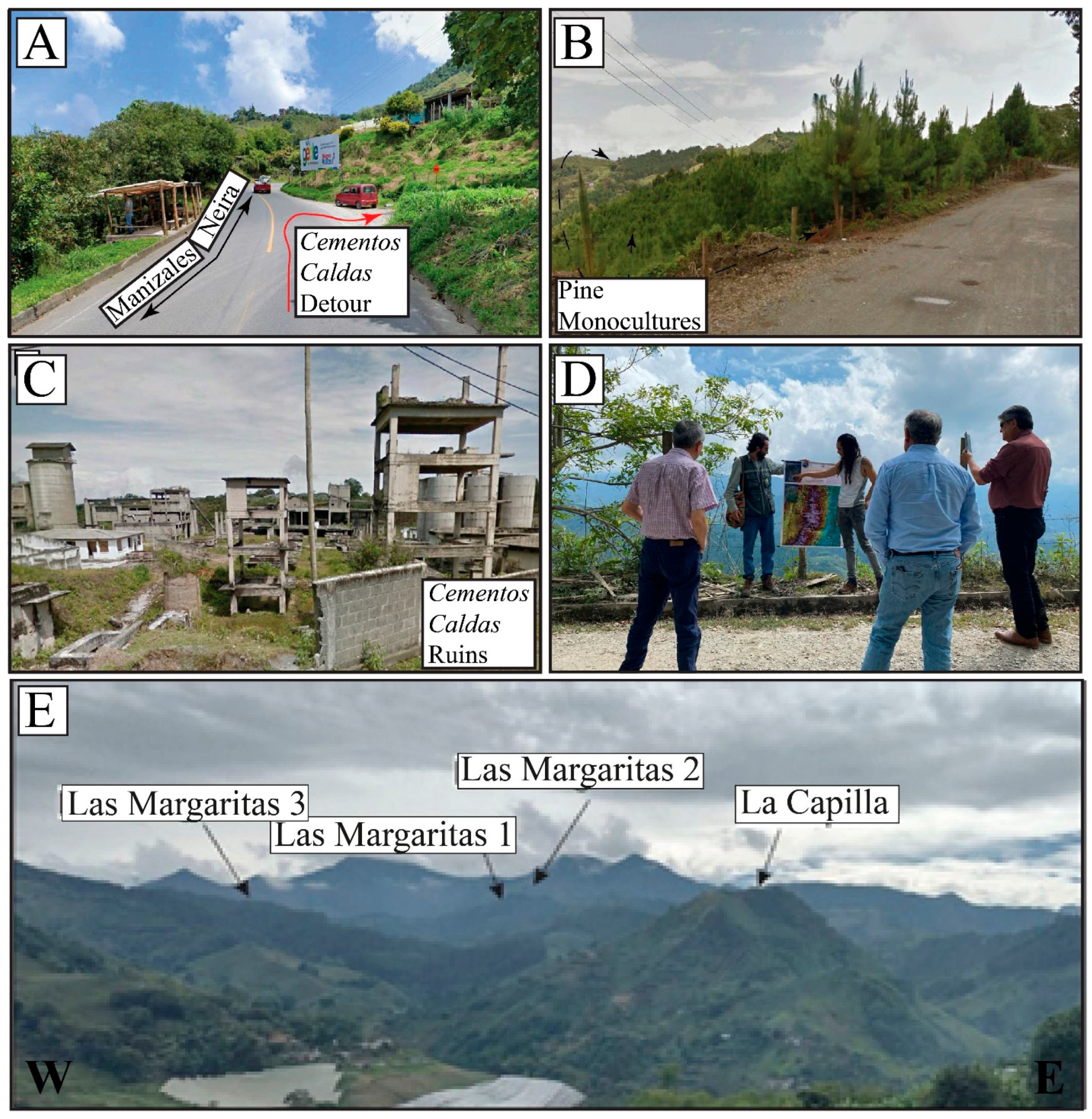
6.2. Georoutes and Geointerpretative Possibilities

A two-tiered georoute is proposed for the TGMVF, tailored to the interests and knowledge levels of different types of visitors (Figure 4). The route includes either three or five interpretive stops, designed to support exploration, reflection, and geoeducation within the volcanic field. The first level consists of three general interpretive stops that provide accessible information focused on the geosystemic context and geodiversity of the region. These are intended to foster broad geoeducational engagement among non-specialist tourists and the general public. The second level adds two additional stops at prominent outcrops within the TGMVF, offering a more technical perspective. These are designed for visitors with a deeper interest in monogenetic volcanism and a basic understanding of geoscientific concepts, enabling a more detailed exploration of the field’s volcanic features.

6.2.1. First Station

This introductory stop takes place at the site locally known as the junction off the intermunicipal road leading to the Cementos Caldas ruins (Figure 5A). Here, the historical and geographical context of the TGMVF is introduced. It sets the stage for a reflective interpretive journey through the region, encouraging participants to consider the role of the human species within the Earth system, and our dependence on the geo-ecosystem services that regulate, sustain, and provide the basic conditions for life, along with culture and knowledge [81,82,83]. Historically, this landscape has been shaped not only by geological forces but also by human migration and settlement. The Antioquean colonization process, which began approximately 200 years ago, involved the movement of rural populations from northern Colombia, particularly the province of Antioquia, southward through mule trails. These movements gave rise to many of the towns that now exist in the departments of Caldas and Risaralda. Over time, settlers adapted to the geosystem to ensure their survival, forging cultural practices deeply interwoven with the region’s natural characteristics. This station also emphasizes geodiversity, both by orienting participants spatially within the landscape and by introducing the complex geological processes that have shaped the Central Cordillera over millions of years. Visitors are invited to reflect on the stark contrast between human and planetary space-time scales: while local culture has developed through two centuries of adaptation, this region’s topography tells a story that unfolds over geologic epochs. By integrating spatial awareness, historical memory, and geological perspective, this first station encourages participants to recognize the interdependent relationship between culture and nature and to begin the georoute experience with a broader awareness of our place within Earth’s dynamic system.

6.2.2. Second Station

This stop invites visitors to confront present-day environmental challenges by examining the tensions between natural ecosystems and human land use in the TGMVF. From this vantage point, tourists are guided to observe the surrounding hills and identify the principal economic activities, primarily agriculture, livestock, and timber production that characterize the landscape. A key feature is the presence of monoculture pine plantations, which serve as a visual cue for interpreting ecological imbalance (Figure 5). Visitors are encouraged to distinguish between areas where nature fulfills productive or economic roles and those where conservation efforts prevail. This contrast highlights the dominant focus on extractive and productive land uses, often at the expense of ecological regulation and sustainability. The presence of pine trees, a non-native species in this ecosystem, offers a case study in the disruption of native geobiological relationships and their cascading impacts on soil, biodiversity, and hydrological dynamics. This station fosters inquiry into the broader consequences of economic practices on natural cycles, such as water and carbon, and the long-term effects of land-use change on ecosystem function [84,85]. Guided observations and discussions help participants connect visual elements of the landscape with deeper systemic processes, encouraging critical thinking about human–environment relationships. Reflective themes at this station emphasize that human transformation of nature is reaching a critical threshold [86,87,88]. As we approach potential tipping points in Earth’s natural cycles, it becomes increasingly urgent to build awareness, not only to prevent irreversible changes, but also to develop adaptive capacities in the face of them.

6.2.3. Third Station

This station revisits the geological framework introduced earlier, using the dome-shaped morphology of La Capilla volcano as an entry point to explain monogenetic volcanism and associated eruptive processes. Visitors are guided through the complex interactions between volcanic activity, tectonic faulting, bedrock, and soil formation within the broader magmatic system of Colombia’s Central Cordillera [47]. La Capilla formed approximately 0.81 million years ago through andesitic magma emplacement [77]. Its rocks exhibit plagioclase, amphibole, and biotite minerals, with a calc-alkaline, medium-to-high K geochemical signature [77]. These features reflect magma sourced from a crustal reservoir 20–30 km deep, linked to the San Diego–Cerro Machín volcano-tectonic province and driven by the subduction of the Nazca Plate beneath South America [77,89]. Magma ascent has been facilitated by extensional zones generated by intersecting fault systems that cut across the region [46]. This geological setting illustrates the importance of studying monogenetic volcanoes, not only to understand their eruptive history but also to assess the potential hazards they pose to surrounding communities. The work of the research group named “Grupo de Investigación en Estratigrafía y Vulcanología (GIEV) Cumanday” from the Universidad de Caldas in Colombia has been instrumental in advancing regional volcanic risk knowledge and in developing accessible, creative strategies to share geoscientific information through geotourism.
From this panoramic viewpoint, the route transitions to the Cementos Caldas ruins, an emblematic example of human dependence on geo-ecosystem services (Figure 5). This abandoned cement factory once extracted limestone lenses rich in CaCO3 (>50%), embedded in greenschist and quartz-sericitic rocks of the Quebradagrande Complex [90]. Although metamorphosed, the limestone was not sufficiently altered to be classified as marble or metadolomite [90]. Open-pit methods were initially used, but slope destabilization due to blasting led to catastrophic landslides. A major 1982 collapse resulted in 11 deaths, one missing person, and 15 injuries [90]. After a switch to underground extraction using chamber-and-pillar methods, the economic viability continued to decline. The factory eventually closed in 1995, leaving its infrastructure abandoned by 1997. Visitors are encouraged to reflect on this history, not just as industrial archeology, but as a cautionary tale about unsustainable resource dependency. A recommended interpretive element includes a local newspaper clipping reporting the factory’s closure due to resource depletion and economic infeasibility. At the time, the closure directly affected more than 200 families and impacted nearly 1000 individuals. This site serves as a case study in the socio-economic consequences of exhausting provisioning services. It prompts discussions about the limits of extractive practices and the urgent need to transition toward more sustainable land use and environmental planning. Drawing on the reflections from the previous station, visitors are invited to consider the planetary implications of continued degradation and overconsumption.
The key message of this first-level georoute, designed for a broad and diverse audience, is that the Earth is finite, and so are the natural resources that sustain human life. When essential systems such as water, soil, and air are degraded or polluted beyond their capacity to regenerate, the consequences can be severe. The closure of the Cementos Caldas factory is a local example of what can happen when resource exhaustion disrupts both ecosystems and livelihoods. If such dynamics are replicated at larger scales, the risk of widespread social and ecological collapse increases. Raising awareness of these risks is not only important for prevention but also for fostering the capacity to adapt, mitigate harm, and work toward more resilient, equitable, and environmentally responsible societies in the face of ongoing planetary crises.

6.2.4. Fourth Station

At the Las Margaritas 3 outcrop, visitors explore its andesitic composition and the evidence of dome destruction, visible through block-and-ash flow deposits. This stop offers insights into early-stage crystallization processes and explains how variations in magma cooling rates and ascent velocities influenced the development of large plagioclase and amphibole crystals. The site bridges petrology with field interpretation, enriching the geoscientific experience for more knowledgeable audiences.

6.2.5. Fifth Station

The final station features Las Margaritas 1, a coulee dome. Tourists observe its andesitic composition and fault-related rock about textures, gaining a deeper understanding of the geological forces that shaped the TGMVF. Designed for visitors with a strong interest in geosciences, this stop supports advanced discussions about monogenetic volcanic evolution, structural geology, and the broader scientific importance of the volcanic field.

6.3. The Strategic Role of the Tapias-Guacaica Monogenetic Volcanic Field in Advancing Geotourism in the Volcán del Ruiz Geopark Project

Within the TGMVF, sites such as La Capilla dome and the Cementos Caldas ruins offer great potential for geotourism development. The proposed georoute exemplifies an interpretive and discursive framework through which visitors can be geoeducated, from fundamental Earth science concepts such as orogeny processes, volcanism, and plate tectonics, to place-based reflections on where we are and what exists in the territory we inhabit. These experiences culminate in moments of critical environmental reflection, aimed at fostering climate consciousness, preventive thinking, and adaptive responses to global change. However, capitalizing on this potential requires deep community engagement. It is essential that local populations not only recognize the value of these geoheritage assets but also see them as integral to their cultural and environmental identity. Fostering the social appropriation of knowledge, where communities connect their daily lives and collective identity to the surrounding geodiversity, is a necessary step for meaningful and lasting impact.
La Capilla’s geological expression and the Cementos Caldas ruins’ industrial legacy offer strong foundations for interpretive geotourism in the TGMVF, yet their success depends on active socio-community participation. The communities inhabiting geoheritage sites are, first and foremost, those with the opportunity to appreciate, enhance, and benefit from development strategies grounded in geoscientific pillars for sustainability (i.e., geoconservation, geodiversity, geoheritage, geoeducation, and geotourism). These communities include not only landowners, farmers, and daily travelers, but also a broader set of socio-economic actors and the political-administrative institutions responsible for legislation, public policy, and budget allocation. Achieving alignment with geoscientific principles requires persistent advocacy and coordination to build shared commitments across stakeholders. Only through collective management, uniting community members, government institutions, and other territorial actors, can sustainable geological heritage management be achieved in ways that enhance both human and natural well-being. In this way, geotourism can fulfill its transformative and sustainable mission by ensuring stable and growing economic flows rooted in the respectful, protective, and harmonious use of natural heritage.
The current lack of official recognition by UNESCO for initiatives aiming to establish geoparks in Colombia is largely attributable to the absence of clear and well-defined management structures. This has resulted in challenging processes and ongoing territorial obstacles that, despite continued efforts, have so far prevented the successful implementation of the country’s first UNESCO Global Geopark. Nevertheless, there are ongoing efforts by numerous individuals, sectors, and stakeholders who continue to transform UNESCO’s conceptual pillars for geoparks into concrete actions, processes, and strategies. The significant potential embedded in this territorial management model, promoted by UNESCO as the Global Geopark, will, sooner rather than later, become a stronger force for fostering and sustaining interinstitutional cooperation, as well as connections among communities, actors, and social roles. This will ultimately enable the establishment and consolidation of geopark strategies as effective tools for territorial, environmental, and cultural development.
The VRGP must assume a leading role in the region, as it carries the primary responsibility for empowering, coordinating, and guiding the development, management, and governance of geoconservation processes related to geodiversity and geoheritage. This includes the integration of geotourism and geoeducational experiences aimed at fostering geoethical behavior, not only at the individual level but across society. The VRGP should serve as a key facilitator for knowledge transfer and social appropriation, activating local capacities and aligning diverse stakeholders, including academic institutions, community organizations, local governments, and producers, around a common vision of sustainable development rooted in geoscientific principles. To expand its territorial impact, the VRGP must also strengthen its governance structure by clearly defining roles, responsibilities, and interinstitutional collaborations. This framework should ensure inclusive participation from institutional, community-based, academic, and productive sectors, allowing for the implementation of interpretive and conceptual proposals that promote transformative, place-based learning experiences grounded in nature and sustainability. Finally, integrating these geosites into broader conservation and territorial planning frameworks is essential. Managing them from a geosystemic perspective will not only protect geological heritage but also promote ecosystem restoration, resilience, and long-term sustainability, reinforcing the region’s geological and cultural identity for generations to come.

7. Conclusions

The Tapias-Guacaica Monogenetic Volcanic Field demonstrates moderate overall potential for geotourism, as evaluated through scientific, educational, touristic, and degradation risk criteria using Brilha’s methodology. Among the assessed sites, La Capilla volcano emerged as a high-potential geosite of volcanological heritage with strong intrinsic geotourism potential, while the Cementos Caldas ruins represent an industrial mining heritage site of significant educational and touristic appeal, characterized by high extrinsic geotourism potential. Their accessibility, geological representativeness, preservation of features, and capacity to support geoeducational narratives, along with their complementary intrinsic and extrinsic geotourism value, make them ideal focal points for geotourism development. Notably, the viewpoint of the Capilla volcano and the entrance to the Cementos Caldas ruins converge in the same area, offering a highly synergistic setting for integrated geotourism experiences, as proposed in the georoute.
The proposed georoute offers a structured and innovative interpretive experience that integrates volcanological, geosystemic, and historical perspectives. It highlights the feasibility of developing educational and recreational spaces that foster environmental awareness, promote preventive and adaptive sustainability practices, and encourage regenerative thinking, while supporting transformative learning for diverse audiences. The TGMVF landscape, shaped by agricultural, livestock, and forestry activities, presents both challenges and opportunities for sustainable territorial planning. Recognizing and addressing the local impacts of these land-use practices, particularly those affecting soil and water systems, is essential for long-term landscape stewardship and resilience.
For geotourism initiatives in the TGMVF to succeed, the social appropriation of geoscientific knowledge must be prioritized. This involves inclusive community engagement in the interpretation, management, and valorization of geological heritage, enabling geotourism to evolve into a participatory and equitable model of territorial development. In this context, the Volcán del Ruiz Geopark Project is well-positioned to lead these efforts. By coordinating governance structures, activating local capacities, and aligning educational, institutional, and productive sectors, the VRGP can serve as a model for integrating geoconservation, geoeducation, and sustainable development. As part of a national strategy, UNESCO Global Geoparks represent a timely and relevant pathway for Colombia to achieve its geotourism and conservation goals while strengthening the cultural and scientific appreciation of its unique geodiverse volcanic landscapes.

Author Contributions

Conceptualization, A.A.-D., E.I.-A. and H.M.; methodology, A.A.-D., H.M., G.B.-C., and A.R.-H.; software, A.A.-D.; validation, A.A.-D. and S.O.-O.; formal analysis, A.A.-D.; investigation, A.A.-D., E.I.-A., G.B.-C., and A.R.-H.; resources, H.M.; data curation, S.O.-O.; writing—original draft preparation, A.A.-D. and E.I.-A.; writing—review and editing, H.M., S.O.-O., and L.A.B.-G.; visualization, A.A.-D. and L.A.B.-G.; supervision, H.M. and S.O.-O.; project administration, H.M.; funding acquisition, H.M. and S.O.-O. All authors have read and agreed to the published version of the manuscript.

Funding

Ministerio de Ciencias, Tecnología e Innovación (MINCIENCIAS) (call 890, 2020) and managed by Instituto Colombiano de Crédito Educativo y Estudios Técnicos en el Exterior—Mariano Ospina Pérez (ICETEX), Colombia.

Data Availability Statement

All data are included in the main text.

Acknowledgments

This study was carried out in the frame of the project titled: “Vulcanismo en el centro y suroccidente del país: Implicaciones de origen, evolución, amenaza, relación con el desarrollo de suelos volcánicos y potencial geoturístico”, funded by Ministerio de Ciencias, Tecnología e Innovación (MINCIENCIAS) (call 890, 2020), Colombia and granted to the “Grupo de Investigación en Estratigrafía y Vulcanología (GIEV) Cumanday” de la Universidad de Caldas, Colombia, “Grupo de Investigación en Recursos Naturales Amazónicos (GRAM), Instituto Tecnológico del Putumayo, Sibundoy, Colombia, and “Grupo de Gestión y Turismo”, Universidad del Pacifico, Buenaventura, Colombia. The funds were managed by Instituto Colombiano de Crédito Educativo y Estudios Técnicos en el Exterior—Mariano Ospina Pérez (ICETEX), Colombia. The Instituto de Investigaciones en Estratigrafía (IIES) is also gratefully acknowledged for providing the physical facilities where this project was carried out.

Conflicts of Interest

The authors declare no conflicts of interest.

Abbreviations

The following abbreviations are used in this manuscript:
TGMVFTapias-Guacaica Monogenetic Volcanic Field
VGRPVolcan del Ruiz Geopark Project
NNNPLos Nevados National Natural Park

References

  1. Rieppel, L. Earth science and extractive capitalism in the age of empire. In Handbook of the Historiography of the Earth and Environmental Sciences; Springer International Publishing: Cham, Switzerland, 2024; pp. 1–24. [Google Scholar] [CrossRef]
  2. Von Engelhardt, W.; Goguel, J.; Hubbert, M.K.; Prentice, J.E.; Price, R.A.; Trümpy, R. Earth resources, time, and man—A geoscience perspective. Environ. Geol. 1976, 1, 193–206. [Google Scholar] [CrossRef]
  3. McDonough, W.F. The composition of the Earth. Int. Geophys. Ser. 2001, 76, 3–23. [Google Scholar]
  4. Prosser, C.D.; Díaz-Martínez, E.; Larwood, J.G. The conservation of geosites: Principles and practice. In Geoheritage; Elsevier: Amsterdam, The Netherlands, 2018; pp. 193–212. [Google Scholar] [CrossRef]
  5. Capello, M.; Caslin, E.; Stewart, I.; Cox, D.; Shaughnessy, A.; Atekwana, E.; Mhopjeni, K. Geoscience in Action: Advancing Sustainable Development; UNESCO: Paris, France, 2023; Available online: https://unesdoc.unesco.org/ark:/48223/pf0000384826 (accessed on 11 April 2025).
  6. Gardiner, N.J.; Roberts, J.J.; Johnson, G.; Smith, D.J.; Bond, C.E.; Knipe, R.; Haszeldine, S.; Gordon, S.; O’Donnell, M. Geosciences and the energy transition. Earth Sci. Syst. Soc. 2023, 3, 10072. [Google Scholar] [CrossRef]
  7. Senger, K. Sustainable Development Goals and the Geosciences: A Review. Earth Sci. Syst. Soc. 2024, 4, 10124. [Google Scholar] [CrossRef]
  8. Van Ree, C.C.D.F.; Van Beukering, P.J.H.; Boekestijn, J. Geosystem services: A hidden link in ecosystem management. Ecosyst. Serv. 2017, 26, 58–69. [Google Scholar] [CrossRef]
  9. Fox, N.; Graham, L.J.; Eigenbrod, F.; Bullock, J.M.; Parks, K.E. Incorporating geodiversity in ecosystem service decisions. Ecosyst. People 2020, 16, 151–159. [Google Scholar] [CrossRef]
  10. Frisk, E.L.; Volchko, Y.; Sandström, O.T.; Söderqvist, T.; Ericsson, L.O.; Mossmark, F.; Lindhe, A.; Blom, G.; Lång, L.-O.; Carlsson, C.; et al. The geosystem services concept—What is it and can it support subsurface planning? Ecosyst. Serv. 2022, 58, 101493. [Google Scholar] [CrossRef]
  11. Karacaoğlu, B.; Akbaba, M.F. Multidisciplinary perspective: A review of the importance of communication in managing climate change challenges. Environ. Res. Technol. 2024, 7, 457–470. [Google Scholar] [CrossRef]
  12. Rodrigues, J.; e Silva, E.C.; Pereira, D.Í. Science Communication Practices in UNESCO Global Geoparks: A Benchmark Analysis. Geosciences 2025, 15, 78. [Google Scholar] [CrossRef]
  13. McKeever, P.J.; Zouros, N.C.; Patzak, M. The UNESCO global network of national geoparks. Georg. Wright Forum 2010, 27, 14–18. Available online: https://www.jstor.org/stable/43598130 (accessed on 11 April 2025).
  14. Gonzalez, E.A.M. El Geoparque Como un Libro Abierto. Naturaleza-Cultura y Procesos de Patrimonialización en la Mixteca alta de Oaxaca. Recurso Impreso, Recurso Electrónico. 2018. Available online: http://ciesas.repositorioinstitucional.mx/jspui/handle/1015/984 (accessed on 11 April 2025).
  15. Herrera-Franco, G.; Montalvan-Burbano, N.; Carrion-Mero, P.; Jaya-Montalvo, M.; Gurumendi-Noriega, M. Worldwide research on geoparks through bibliometric analysis. Sustainability 2021, 13, 1175. [Google Scholar] [CrossRef]
  16. Ferreira, D.R.; Valdati, J. Geoparks and Sustainable Development: Systematic Review. Geoheritage 2023, 15, 6. [Google Scholar] [CrossRef]
  17. Gordon, J.E. Geoheritage, geotourism and the cultural landscape: Enhancing the visitor experience and promoting geoconservation. Geosciences 2018, 8, 136. [Google Scholar] [CrossRef]
  18. Acevedo, R.D.; Martínez-Frías, J. Geoethics in Latin America; Springer International Publishing: Cham, Switzerland, 2018. [Google Scholar] [CrossRef]
  19. Palacio Prieto, J.L.; Rosado González, E.M.; Martínez Miranda, G.M. Geoparques. In Guía para la Formulación de Proyectos; Instituto de Geografia, UNAM: Mexico City, Mexico, 2018. [Google Scholar] [CrossRef]
  20. Ribeiro, T.; Cardoso, A.; Silva, J.; Lima, D.; Vasconcelos, C. Geoethics Calls for Action: An Interactive Module to Communicate Geosciences. In Advances in Geoethics and Groundwater Management: Theory and Practice for a Sustainable Development, Proceedings of the 1st Congress on Geoethics and Groundwater Management (GEOETH&GWM’20), Porto, Portugal, 2020; Springer International Publishing: Cham, Switzerland, 2021; pp. 363–366. [Google Scholar] [CrossRef]
  21. Vasconcelos, C.; Orion, N. Earth science education as a key component of education for sustainability. Sustainability 2021, 13, 1316. [Google Scholar] [CrossRef]
  22. Peppoloni, S.; Di Capua, G. The significance of geotourism through the lens of geoethics. In Geotourism in the Middle East; Springer International Publishing: Cham, Switzerland, 2023; pp. 41–52. [Google Scholar] [CrossRef]
  23. Rodrigues, J.; Costa e Silva, E.; Pereira, D.I. How can geoscience communication foster public engagement with geoconservation? Geoheritage 2023, 15, 32. [Google Scholar] [CrossRef]
  24. Pescatore, E.; Bentivenga, M.; Giano, S.I. Geoheritage and geoconservation: Some remarks and considerations. Sustainability 2023, 15, 5823. [Google Scholar] [CrossRef]
  25. Fernandes, G.P. Geotourism and Sustainability. In Encyclopedia of Sustainable Management; Idowu, S., Schmidpeter, R., Capaldi, N., Zu, L., Del Baldo, M., Abreu, R., Eds.; Springer: Cham, Switzerland, 2023. [Google Scholar] [CrossRef]
  26. Quesada-Valverde, M.E.; Quesada-Román, A. Worldwide trends in methods and resources promoting geoconservation, geotourism, and geoheritage. Geosciences 2023, 13, 39. [Google Scholar] [CrossRef]
  27. Farabollini, P.; Bendia, F.; Bignami, L. Geological Wonders of Italy: The Coveted Privilege of Disseminating Geology and Geomorphology through Science Documentaries. Land 2024, 13, 1451. [Google Scholar] [CrossRef]
  28. Koupatsiaris, A.A.; Drinia, H. Expanding Geoethics: Interrelations with Geoenvironmental Education and Sense of Place. Sustainability 2024, 16, 1819. [Google Scholar] [CrossRef]
  29. Molokáč, M.; Kornecká, E.; Tometzová, D. Proposal for Effective Management of Geoparks as a Tool for Sustainable Tourism in the Conditions of the Slovak Republic. Land 2024, 13, 1104. [Google Scholar] [CrossRef]
  30. Comănescu, L.; Nedelea, A. The assessment of geodiversity—A premise for declaring the geopark Buzăului County (Romania). J. Earth Syst. Sci. 2012, 121, 1493–1500. [Google Scholar] [CrossRef]
  31. Carcavilla-Urqui, L.; López-Martínez, J.; Durán-Valsero, J.J. Patrimonio Geológico y Geodiversidad: Investigación, Conservación, Gestión y Relación con los Espacios Naturales Protegidos; Instituto Geológico y Minero de España: Madrid, Spain, 2007; p. 360. ISBN 978-84-7840-710-1. Available online: https://www.researchgate.net/publication/259011390_Patrimonio_geologico_y_geodiversidad_investigacion_conservacion_y_relacion_con_los_espacios_naturales_protegidos (accessed on 11 April 2025).
  32. Shekhar, S.; Kumar, P.; Chauhan, G.; Thakkar, M.G. Conservation and sustainable development of geoheritage, geopark, and geotourism: A case study of Cenozoic successions of Western Kutch, India. Geoheritage 2019, 11, 1475–1488. [Google Scholar] [CrossRef]
  33. Frey, M.L. Geotourism—Examining tools for sustainable development. Geosciences 2021, 11, 30. [Google Scholar] [CrossRef]
  34. Hose, T.A. Evaluating interpretation at Hunstanton. Earth Herit. 1995, 4, 20. [Google Scholar]
  35. Hose, T.A. Selling the Story of Britain’s Stone. Environ. Interpret. 1995, 10, 16–17. [Google Scholar]
  36. Chen, A.; Lu, Y.; Ng, Y.C. The Principles of Geotourism; Springer: Berlin/Heidelberg, Germany, 2015. [Google Scholar] [CrossRef]
  37. Wyse Jackson, P.N. Four Centuries of Geological Travel: The Search for Knowledge on Foot, Bicycle, Sledge and Camel; Geological Society of London Special Publications: London, UK, 2007; p. 287. ISBN 186239234X/9781862392342. Available online: https://www.researchgate.net/publication/264383365_Four_Centuries_of_Geological_Travel_The_Search_for_Knowledge_on_Foot_Bicycle_Sledge_and_Camel (accessed on 11 April 2025).
  38. Migoń, P. Geoheritage and geotourism: A European perspective. Geologos 2018, 24, 173–174. [Google Scholar] [CrossRef]
  39. Hilario, A.; Asrat, A.; van Wyk de Vries, B.; Mogk, D.; Lozano, G.; Zhang, J.; Brilha, J.; Vegas, J.; Lemon, K.; Carcavilla, L.; et al. The First 100 IUGS Geological Heritage Sites; International Union of Geological Sciences (IUGS): Zumaia, Spain, 2022; ISBN 978-1-7923-9975-6. [Google Scholar]
  40. Naranjo, J.L.; Sigurdsson, H.; Carey, S.N.; Fritz, W. Eruption of the Nevado del Ruiz volcano, Colombia, on 13 November 1985: Tephra fall and lahars. Science 1986, 233, 961–963. [Google Scholar] [CrossRef]
  41. Voight, B. The 1985 Nevado del Ruiz volcano catastrophe: Anatomy and retrospection. J. Volcanol. Geotherm. Res. 1990, 44, 349–386. [Google Scholar] [CrossRef]
  42. Stern, C.R. Active Andean volcanism: Its geologic and tectonic setting. Rev. Geológica De Chile 2004, 31, 161–206. [Google Scholar] [CrossRef]
  43. Monsalve–Bustamante, M.L.; Gómez, J.; Núñez–Tello, A. Rear–arc small–volume basaltic volcanism in Colombia: Monogenetic volcanic fields. In The Geology of Colombia; Gómez, J., Pinilla–Pachon, A.O., Eds.; Volume 4 Quaternary; Servicio Geológico Colombiano, Publicaciones Geológicas Especiales 38: Bogotá, Colombia, 2020; pp. 353–396. [Google Scholar] [CrossRef]
  44. Gutscher, M.A.; Spakman, W.; Bijwaard, H.; Engdahl, E. Geodynamics of flat subduction: Seismicity and tomographic constraints from the Andean margin. Tectonics 2000, 19, 814–833. [Google Scholar] [CrossRef]
  45. Vargas-Arcila, L.; Murcia, H.; Osorio-Ocampo, S.; Sánchez-Torres, L.; Botero-Gómez, L.A.; Bolaños, G. Effusive and evolved monogenetic volcanoes: Two newly identified (~ 800 ka) cases near Manizales City, Colombia. Bull. Volcanol. 2023, 85, 42. [Google Scholar] [CrossRef]
  46. Murcia, H.; Borrero, C.; Németh, K. Overview and plumbing system implications of monogenetic volcanism in the northernmost Andes’ volcanic province. J. Volcanol. Geotherm. Res. 2019, 383, 77–87. [Google Scholar] [CrossRef]
  47. Echeverri, S.; Murcia, H.; Botello, E.; Valencia-Gómez, J.C.; Cardona, A.; Rosero, S.; Botero-Gómez, L.A.; Valencia, V. Late Miocene–Pliocene eastward magmatic arc migration record in the Northern Andes at 5° N latitude, west-central Colombia. Int. Geol. Rev. 2025, 1–29. [Google Scholar] [CrossRef]
  48. Maya, M.; González, H. Unidades litodémicas en Cordillera Central de Colombia. Bol. Geol. 1995, 35, 44–57. [Google Scholar] [CrossRef]
  49. Gonzalez, H. Geologia de las Planchas 206 Manizales y 225 Nevado del Ruiz. Memoria Explicativa; Memoria explicativa; Instituto de investigación e información geocientifica, minero-ambiental y nuclear. INGEOMINAS: Medellín, Colombia, 2001; p. 89. [Google Scholar]
  50. Toussaint, J.F.; Restrepo, J.J. Tectonostratigraphic terranes in Colombia: An Update Second Part: Oceanic Terranes. In He Geology of Colombia; Gómez, J., Mateus-Zabala, D., Eds.; Proterozoic—Paleozoic; Servicio Geológico Colombiano, Publicaciones Geológicas Especiales: Bogotá, Colombia, 2020; Volume 1. [Google Scholar]
  51. Salazar-Muñóz, N.; de la Ossa, C.A.R.; Murcia, H.; Schonwalder-Ángel, D.; Botero-Gómez, L.A.; Hincapié, G.; da Silva, J.C.; Sánchez-Torres, L. Andesitic (SiO2: ~60 wt%) monogenetic volcanism in the northern Colombian Andes: Crystallisation history of three Quaternary volcanoes. J. Volcanol. Geotherm. Res. 2021, 412, 107194. [Google Scholar] [CrossRef]
  52. Álvarez, J.A. Geología del Complejo Ofiliolítico de Pácora y secuencias relacionadas de Arco de Islas (Complejo quebrada Grande), Colombia. Bol. Geol. 1995, 35, 5–49. [Google Scholar] [CrossRef]
  53. Estrada, J.J.; Viana, R.; Gonzalez, H. Geologia de la Plancha 205 Chinchiná; Memoria explicativa; Instituto de investigación e información geocientifica, minero-ambiental y nuclear. INGEOMINAS: Medellín, Colombia, 2001; p. 93. [Google Scholar]
  54. Moreno-Sánchez, M.; Gómez Cruz, A.D.J.; Toro, L.M. Complex quebradagrande source of clastic material and their relationship with adjacent structural complex. Boletín Cienc. Tierra 2008, 22, 27–38. [Google Scholar]
  55. Nivia, A.; Marriner, G.; Kerr, A.; Tarney, J. The Quebradagrande Complex: A Lower Cretaceous ensialic marginal basin in the Central Cordillera of the Colombian Andes. J. S. Am. Earth Sci. 2006, 21, 423–436. [Google Scholar] [CrossRef]
  56. Botero-Gómez, L.A.; Murcia, H.; Hincapié-Jaramillo, G. The effect of fault systems on volcanic activity: Insights from the subduction-related, Quaternary Villamaría-Termales monogenetic volcanic field in Colombia. J. Volcanol. Geotherm. Res. 2023, 444, 107969. [Google Scholar] [CrossRef]
  57. Molina, J.M.; Mercado, M. Patrimonio Geológico, Minero y Geoturístico. Enfoque Conceptual y de Casos en Colombia; Instituto Colombiano de Geología y Minería (INGEOMINAS): Medellín, Colombia, 2003; Available online: https://books.google.com/books?hl=es&lr=&id=LdXW09PLxU0C&oi=fnd&pg=PA169&dq=Molina,+J.+M.,+%26+Mercado,+M.+(2003).+Patrimonio+geol%C3%B3gico,+minero+y+geotur%C3%ADstico.+Enfoque+conceptual+y+de+casos+en+Colombia.+Instituto+Colombiano+de+Geolog%C3%ADa+y+Miner%C3%ADa+(INGEOMINAS).&ots=8vRHfORh-x&sig=wHxjNASOdt_la2Ch1STphIT8rh4 (accessed on 11 April 2025).
  58. Gómez, J.; Montes, N.E.; Marín, E. Mapa Geológico de Colombia 2023. Escala 1:1 500 000. Servicio Geológico Colombiano. Bogotá. 2023. Available online: https://www2.sgc.gov.co/MGC/Paginas/mgc_1_5M2023.aspx (accessed on 11 April 2025).
  59. Castaño, H. Turismo Etnico, las Comunidades Indígenas y los Atractivos Naturales de sur de Colombia. Revista Intersección: Eventos, Turismo, Gastronomía y Moda. Año 2, N3. ISSN 2357-5875. Tecnología en Organización de Eventos. Facultad de Comunicación Audiovisual. Grupo de Investigación en Comunicación-GIC. Politécnico Colombiano Jaime Isaza Cadavid. Medellín-Colombia & Facultad de Ciencias de la Comunicación de la Universidad Autónoma de San Luis Potosí-UASLP-México. 2016, pp. 61–71. Available online: https://revistas.elpoli.edu.co/index.php/int/article/view/785 (accessed on 11 April 2025).
  60. Arango Gaviria, O. Eco-región eje cafetero: Una experiencia de desarrollo regional en Colombia. ACE Archit. City Environ. 2008, 199–200. [Google Scholar] [CrossRef]
  61. Czerny, M.; Mendoza, C.A.S.; Czerny, A.; Giraldo, D.S.S. Cultural heritage and the development of sustainable tourism in the Eje Cafetero region of Colombia. Ekon. Probl. Tur. 2018, 44, 83–99. [Google Scholar] [CrossRef]
  62. Cifuentes-Correa, L.; Quiroz-Fabra, J.; Valencia-Arias, A.; Londoño-Celis, W.; Hincapie, M. Methodological proposal to determine the potential of a territory to become a UNESCO Geopark: Case study of Nevado del Ruiz Volcano initiative, Colombia. Epis. J. Int. Geosci. 2023, 46, 551–562. [Google Scholar] [CrossRef]
  63. Betancurth, L. El Patrimonio Geológico-Minero del eje Cafeterocuenca del rio Chinchina—Colombia. In Geológico y Minero en el Contexto del Cierre de Minas; CYTED: Cambridge, UK, 2003; p. 149. Available online: https://www.academia.edu/download/39561661/patrimonio-geologico-y-minero-en-el-contexto-del-cierre-de-minas.pdf#page=157 (accessed on 11 April 2025).
  64. Tavera, M.A. Evaluación e implementación de una propuesta de patrimonio geológico en el Parque Nacional Natural Los Nevados Cordillera Central colombiana. Cuadernos del Museo Geominero. In Patrimonio Geológico y Geoparques, Avances de un Camino Para Todos; Instituto Geológico y Minero de España: Madrid, Spain, 2015; Available online: https://repository.eafit.edu.co/server/api/core/bitstreams/72ab694f-0a03-4572-a696-da728652bf67/content (accessed on 11 April 2025).
  65. Tavera Escobar, M.Á.; Estrada Sierra, N.; Errázuriz Henao, C.; Hermelin, M. Georutas o itinerarios geológicos: Un modelo de geoturismo en el Complejo Volcánico Glaciar Ruiz-Tolima, Cordillera Central de Colombia. Cuad. Geogr. Rev. Colomb. Geogr. 2017, 26, 219–240. [Google Scholar] [CrossRef]
  66. SGC, Servicio Geológico Colombiano. Proyecto Geoparque Volcánico El Ruiz. Plan de Manejo. Componente Geológico; Documento Administrativo-Técnico Interno Proyecto Geoparque Volcán del Ruiz; Museo Geológico José Royo y Gómez; Bogotá, Ministerio de Minas: Bogotá, Colombia, 2018. [Google Scholar]
  67. Nova, J.S. Identificación, Caracterización y Valoración de Lugares de Interés Geológico para el Proyecto Geoparque Volcán del Ruiz as-Pirante UNESCO en Colombia: Parte I. Trabajo de grado Universidad de Caldas. Manizales. 2020. Available online: https://catalogo.ucaldas.edu.co/cgi-bin/koha/opac-detail.pl?biblionumber=85289 (accessed on 11 April 2025).
  68. Yate-Rojas, T.M. Identificación, Caracterización y Valoración de Lugares de Interés Geológico para el Proyecto Geoparque Volcán del Ruiz as-Pirante UNESCO en Colombia: Parte II. Trabajo de Grado Universidad de Caldas. Manizales. 2021. Available online: https://catalogo.ucaldas.edu.co/cgi-bin/koha/opac-detail.pl?biblionumber=84905 (accessed on 11 April 2025).
  69. Botero-Vallejo, S.J. Identificación, Caracterización y Valoración de Lugares de Interés Geológico para el Proyecto Geoparque Volcán del Ruiz as-pirante UNESCO en Colombia, Parte III. 2022. Available online: https://repositorio.ucaldas.edu.co/handle/ucaldas/17565 (accessed on 11 April 2025).
  70. Jaramillo Valencia, D. Reconocimiento de Lugares de Interés Geológico en el Flanco Oriental del Volcán Nevado del Ruiz: Contribución Desde la Vulcanología Física a la Conservación y al Turismo Especializado en el Parque Nacional Natural Los Nevados. 2024. Available online: https://repositorio.ucaldas.edu.co/handle/ucaldas/19929 (accessed on 11 April 2025).
  71. Arias-Díaz, A.; Murcia, H.; Vallejo-Hincapié, F.; Németh, K. Understanding Geodiversity for Sustainable Development in the Chinchiná River Basin, Caldas, Colombia. Land 2023, 12, 2053. [Google Scholar] [CrossRef]
  72. Ceballos, J.; Tobón, E. Glaciares Colombianos: Evolución reciente y estado actual. Bol. Geol. 2007, 29, 143–151. [Google Scholar]
  73. Ceballos, J.L. Manifestación de Cambio Climático—Los Glaciares de Colombia. Revista La Tadeo (Cesada a Partir De 2012), (74). 2009. Available online: https://revistas.utadeo.edu.co/index.php/RLT/article/view/516 (accessed on 11 April 2025).
  74. RAP “Región de Administración y Planificación-Eje cafetero”. Acuerdo Regional No. 008. Plan Regional de Turismo. Caldas, Quindio, Risaralda, Tolima, Columbia. 2023. Available online: https://ejecafeterorap.gov.co/wp-content/uploads/2024/03/Plan_regional_turismo.pdf (accessed on 11 April 2025).
  75. Marulanda, C.E.; López, M.; Gómez, C.H. Knowledge management and intellectual capital of companies in the tourism sector in the Department of Caldas-Colombia. Ing. Compet. 2022, 24, 1–15. [Google Scholar] [CrossRef]
  76. Brilha, J. Inventory and quantitative assessment of geosites and geodiversity sites: A review. Geoheritage 2016, 8, 119–134. Available online: https://link.springer.com/article/10.1007/s12371-014-0139-3 (accessed on 11 April 2025). [CrossRef]
  77. Raigosa, S. Aporte a los Estudios Cartográficos, Composicionales y Geocronológicos del Campo Volcánico Monogenético Tapias-Guacaica Municipio de Neira, Caldas, Colombia. Bachelor’s Thesis, Universidad de Caldas, Manizales, Colombia, 1991. Available online: https://repositorio.ucaldas.edu.co/handle/ucaldas/17142 (accessed on 11 April 2025).
  78. Fuertes-Gutiérrez, I.; Fernández-Martínez, E. Geosites inventory in the Leon Province (Northwestern Spain): A tool to introduce geoheritage into regional environmental management. Geoheritage 2010, 2, 57–75. [Google Scholar] [CrossRef]
  79. Botero-Gómez, L.A.; Osorio, P.; Murcia, H.; Borrero, C.; Grajales, J.A. The Villamaria-Termales Monogenetic Volcanic Field, Central Cordillera, Colombian Andes (Part I): Morphological features and temporal relationships. Bol. Geol. 2018, 40, 85–102. [Google Scholar] [CrossRef]
  80. Arias Díaz, A. A Comprehensive Geodiversity Assessment in the Chinchiná River Basin: Identification and Quantification of Classes, Subclasses and Abiotic Elements, Methodological Constraints, Spatial Distributions Patterns, Geosystem Services, Structure, Functionality, and Applications for Strengthening Sustainability. Ph.D. Thesis, Facultad de Ciencias Exactas y Naturales, Buenos Aires, Argentina, 2024. Available online: https://repositorio.ucaldas.edu.co/handle/ucaldas/19886 (accessed on 11 April 2025).
  81. Gray, M. The confused position of the geosciences within the “natural capital” and “ecosystem services” approaches. Ecosyst. Serv. 2018, 34, 106–112. [Google Scholar] [CrossRef]
  82. Van Ree, C.C.D.F.; Van Beukering, P.J.H. Geosystem services: A concept in support of sustainable development of the subsurface. Ecosyst. Serv. 2016, 20, 30–36. [Google Scholar] [CrossRef]
  83. Gordon, J.E.; Barron, H.F. The role of geodiversity in delivering ecosystem services and benefits in Scotland. Scott. J. Geol. 2013, 49, 41–58. [Google Scholar] [CrossRef]
  84. Steffen, W.; Broadgate, W.; Deutsch, L.; Gaffney, O.; Ludwig, C. The trajectory of the Anthropocene: The great acceleration. Anthr. Rev. 2015, 2, 81–98. [Google Scholar] [CrossRef]
  85. Rockström, J.; Steffen, W.; Noone, K.; Persson, Å.; Chapin, F.S., III; Lambin, E.F.; Lenton, T.M.; Scheffer, M.; Folke, C.; Schellnhuber, H.J.; et al. A safe operating space for humanity. Nature 2009, 461, 472–475. [Google Scholar] [CrossRef] [PubMed]
  86. Rockström, J.; Steffen, W.; Noone, K.; Persson, Å.; Chapin, F.S., III; Lambin, E.F.; Lenton, T.M.; Scheffer, M.; Folke, C.; Schellnhuber, H.J.; et al. Planetary Boundaries: Exploring the Safe Operating Space for Humanity. Ecol. Soc. 2009, 14, 32. Available online: http://www.ecologyandsociety.org/vol14/iss2/art32/ (accessed on 11 April 2025). [CrossRef]
  87. Steffen, W.; Richardson, K.; Rockström, J.; Cornell, S.E.; Fetzer, I.; Bennett, E.M.; Biggs, R.; Carpenter, S.R.; De-Vries, W.; De-Wit, C.A.; et al. Planetary boundaries: Guiding human development on a changing planet. Science 2015, 347, 1259855. [Google Scholar] [CrossRef]
  88. Richardson, K.; Steffen, W.; Lucht, W.; Bendtsen, J.; Cornell, S.E.; Donges, J.F.; Druke, M.; Fetzer, I.; Bala, G.; Von-Bloh, W.; et al. Earth beyond six of nine planetary boundaries. Sci. Adv. 2023, 9, eadh2458. [Google Scholar] [CrossRef]
  89. Monsalve–Bustamante, M.L. The Volcanic Front in Colombia: Segmentation and Recent and Historical Activity. In The Geology of Colombia; Gómez, J., Pinilla–Pachon, A.O., Eds.; Volume 4 Quaternary; Servicio Geológico Colombiano, Publicaciones Geológicas Especiales 38: Bogotá, Colombia, 2020; pp. 97–159. [Google Scholar] [CrossRef]
  90. Cruz-Rivera, J.F. Registro Geotécnico en los Túneles de la Mina “La Concha”: Práctica Realizada Entre Agosto/90 y Feb/91. Bachelor’s Thesis, Facultad de Geología y Minas, Universidad de Caldas, Manizales, Colombia, 1991. [Google Scholar]
Figure 1. Monogenetic volcanic field localization. (A) Regional geological context. WC: Western Cordillera, CC: Central Cordillera, EC: Eastern Cordillera. Red boxes: Colombian volcanic segments (B) VRGP: Volcán del Ruiz Geopark Project perimeter, NNNP: Nevados National Natural Park. Black box: Tapias-Guacaica Monogenetic Volcanic Field. (C) Tapias-Guacaica Monogenetic Volcanic Field: 1—El Encanto; 2—La Capilla; 3—Las Margaritas 3; 4—Las Margaritas 1; 5—Las Margaritas 2; 6—La Camella; 7—La Cristalina; 8—La Sierra.
Heritage 08 00185 g001
Figure 2. Geological map of the area of interest. Geological units, hatching, and colors adapted from [48,52,57]. Fault systems taken from [46,58].
Heritage 08 00185 g002
Figure 3. (A) La Capilla volcano. (B) Outcrop of Las Margaritas 3 volcano. (C) Outcrop of Las Margaritas 1 volcano. (D) Outcrop of Las Margaritas 2 volcano. (E) Outcrop of El Encanto volcano. (F) Outcrop of La Cristalina 1 volcano. (G) Outcrop of La Cristalina 2 volcano. (H) Abandoned ruins of the old Cementos Caldas factory.
Heritage 08 00185 g003
Figure 4. Tapias-Guacaica Monogenetic Volcanic Field georoute.
Heritage 08 00185 g004
Figure 5. Interpretative stations of the proposed georoute. (A) First station: junction toward Cementos Caldas—general geological and geographical introduction. (B) Pine monocultures—reflections on land use and natural cycles. (C) General view of Cementos Caldas ruins. Reflection on the depletion of geosystemic provisioning services. (D) Testing the georoute using maps and interpretive tools for the spatial visualization and understanding of monogenetic volcanic processes. (E) Panoramic view of the monogenetic volcanic field.
Heritage 08 00185 g005
Table 1. Systematic assessment of geological heritage. Based on [1].
Parameter% Relative Weight of the Criterion
ScientificEducationalTouristicRisk
Representativeness (R)30
Key locality (KL)20
Integrity (I)15
Rarity (Ra)15
Usage limitations (UL)1055
Scientific knowledge (SK)5
Didactic potential (DP) 20
Observation conditions (OC) 105
Vulnerability (V) 1010
Accessibility (A) 101015
Safety (S) 1010
Geodiversity (G)510
Association with other values (AOV) 55
Scenery (Sc) 515
Interpretative potential (IP) 10
Logistic (Lo) 55
Density of population (DoP) 5510
Uniqueness (U) 510
Economic level (EL) 5
Proximity of recreational areas (PRA) 5
Deterioration of geological elements (DGE) 35
Proximity to degradation areas (PDA) 20
Legal protection (LP) 20
Total100100100100
Table 2. Scientific parameter qualification of Tapias-Guacaica Monogenetic Volcanic Field.
Scientific ParameterRKLIRaULSKGTotal
% Relative Weight302015151055
Geoheritage siteQualification (0–4)
La Capilla4242314305
Las Margaritas 32122414205
Las Margaritas 12222444240
Las Margaritas 22231344230
El Encanto2142404230
La Cristalina 11121404155
La Cristalina 21121404155
La Camella1111404140
Cementos Caldas ruins2123214200
Table 3. Educational parameter qualification of Tapias-Guacaica Monogenetic Volcanic Field.
Educational ParameterDPOCVASGULAOVScLoDoPUTotal
% Relative Weight201010101010555555
Geoheritage siteQualification (0–4)
La Capilla442324444413330
Las Margaritas 3312224442413260
Las Margaritas 1312224442412255
Las Margaritas 2322214443312255
El Encanto342214242413270
La Cristalina 1232224441212240
La Cristalina 2222124441212220
La Camella112214341212185
Cementos Caldas ruins433224243413305
Table 4. Touristic parameter qualification of Tapias-Guacaica Monogenetic Volcanic Field.
Touristic ParameterAOVVASScIPULOCLoDoPUELPRATotal
% Relative Weight5101010151055551055
Geoheritage siteQualification (0–4)
La Capilla4222444441323300
Las Margaritas 34222224141322230
Las Margaritas 14222224141222220
Las Margaritas 24221324231222225
El Encanto4321222441323240
La Cristalina 14222124321222205
La Cristalina 24212124221222190
La Camella4321113121222180
Cementos Caldas ruins4222342341323270
Table 5. Degradation risk parameter qualification for the Tapias-Guacaica Monogenetic Volcanic Field.
Degradation Risk ParameterDGEPDALPVATotal
% Relative Weight3520201510
Geoheritage siteQualification (0–4)
La Capilla24322260
Las Margaritas 333422295
Las Margaritas 123422260
Las Margaritas 223422260
El Encanto24432295
La Cristalina 133422295
La Cristalina 231421245
La Camella23432275
Cementos Caldas ruins32422275
Disclaimer/Publisher’s Note: The statements, opinions and data contained in all publications are solely those of the individual author(s) and contributor(s) and not of MDPI and/or the editor(s). MDPI and/or the editor(s) disclaim responsibility for any injury to people or property resulting from any ideas, methods, instructions or products referred to in the content.

