1. Introduction
The Laboratory of Architectural, Cultural, and Patrimonial Landscape (LAB/PAP) is a research group at the University of Valladolid, whose primary line of research focuses on the intervention and recovery of cultural and archaeological heritage landscapes [
1]. As a Recognised Research Group, it is characterised by a high level of specialisation in the field of heritage, with the development of a specific methodology of study, analysis, and architectural intervention in the heritage landscapes in which it is called to operate [
2].
The term “Heritage Landscape” is used to define a set of elements, natural or man-made, articulated around valuable architectural remains with a certain degree of visibility, forming a series of superimposed memories over time, like a magnificent palimpsest. They constitute important systems to understand the cultural evolution of the territory, serving as a tangible memory of our past, socially, historically, and in terms of identity. However, they are usually difficult to interpret, even for those familiar with the subject [
3].
All citizens, regardless of age or disability, should be able to visit these sites to explore and enjoy their landscape values and architectural remains, interpreted by specialists, regardless of age or disability [
4] (p. 11). However, reconciling accessibility and heritage requires a sensitive perception of the environment and people’s disabilities. Finding the right balance between the two is rather difficult. As José Antonio Juncà Ubierna explains, the development of a single objective and a universal theory of accessibility in heritage is impossible [
5] (p. 6). Each case should be studied in depth in order to provide sensitive, useful, reasonable, and respectful solutions, and therefore, finding this balance proves to be demanding and arduous [
6] (p. 24).
Even though more and more institutions and companies are convinced that it should be addressed from a social point of view, it has been often considered only from a physical accessibility perspective. Marco Antonio Garcés explains that designers should not only consider physical barriers:
"All good architecture is rich in flexibility, textures, proper layout and adaptation to the environment. Barriers for those who perceive and go through architectural spaces are not only those that have to do with entrances, exits or transit, but also those that refer to nuances, textures, proportion, orientation, sunlight, the smell" [
7] (p. 43).
The aforementioned difficulty in finding a balance between accessibility and heritage often lies in the diversity of situations, which are difficult to adapt to specific canons or regulations. We can therefore observe that in most cases only partial solutions have been offered, while a more comprehensible, truly sustainable, and inclusive approach needs to be adopted. The concept of inclusive design, which means embracing diversity, is essential to achieving the abovementioned balance.
Achieving accessibility involves accessing and using the cultural site and its surroundings, as well as perceiving and understanding the inherent meaning of the cultural site [
8] (p. 7). In this sense, information design can play an essential role for the enjoyment and spread of knowledge of heritage landscapes. However, although these sites often have signage and even didactic interpretation centres, the information has not always been delivered in a way that suits the architectural and landscape project, nor with the parameters of inclusive design. It is essential to make a coordinated and multidisciplinary effort to approach projects from this perspective. This means that information design must be harmonised with architecture and landscape, in its definition of spaces, itineraries, and flows, and with the logistics of services, in the creation of networks and the definition of information and management points. The inclusion of wayfinding resources requires a collaborative effort from architects, designers, and sign creators [
9].
With the intention of promoting this multidisciplinary approach and taking advantage of the ongoing teaching in Architecture and Engineering in Industrial Design and Product Development, the authors began to consider that it could be enriching for these students to carry out their final projects following a line of research that is being developed within the research group: Information Design in Heritage Landscapes. The paper aims to show some reflections on this topic, which have led a group of students and lecturers within the LAB/PAP to develop experimental information and design proposals for the archaeological site of Tiermes, in Soria, Spain.
The archaeological site of Tiermes (Montejo de Tiermes, Soria) stands imposingly in a geographically privileged landscape, singularised by the natural topography of a terraced hill of red sandstone; a place inhabited and anthropised by man over time, with the Roman occupation standing out [
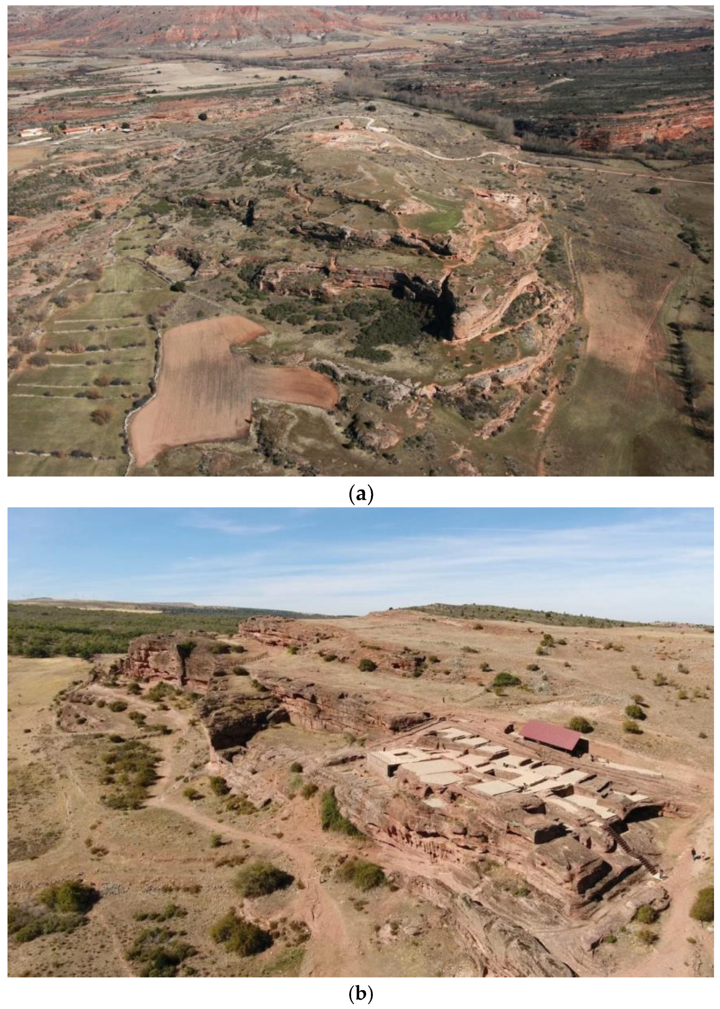
10]. The acropolis of the Roman city was located on this elevated site, using the rocky elevation as a natural fortification (
Figure 1a). The transformation of the original topography has left important remains of buildings carved into the rock, large ditches in the streets, and an extensive network of excavated aqueducts, more than a kilometre long, which used to supply water for a city with the status of a Roman
municipium. Apart from the remains of the urban infrastructures, important archaeological vestiges are still preserved in the centre of the city, in the surroundings of the Romanesque hermitage of Tiermes, such as the late imperial wall, which from the third century onwards used to protect the east side of the city, and the Roman Forum, whose settlement benefits from the topographical unevenness on two levels: an upper square with temples on the north side and taverns on the rest, and a lower level with taverns and a perimeter
loggia open to the landscape. The Thermal Bath complex sits on a lower terrace and took full advantage of the elevation of the hill.
On the
Frente Sur (Southern Front) of the site, probably the most densely built part of the city, with a good orientation and views of the surrounding landscape of the Sierra de Pela, the remains of several groups of dwellings are still preserved, which utilise the large rock cliffs as structural support (
Figure 1b), with putlog holes still visible, and a series of spaces excavated in the sandstone rock that were originally used as storage areas for these dwellings. Of particular interest are the
Casas de Taracena, a group of two-storey semi-detached houses linked by internal staircases, and the
Casa del Acueducto (House of the Aqueduct, named after the pipe that runs along the adjacent street), with taverns and rooms partly dug into the rock, which still have the remains of the ceramic flooring that made them suitable for living comfortably. They used to form one or two large
domus, organised around two large
impluvia, which offered a privileged position wherefrom they could have enjoyed the unique views.
The working methodology used is set out below, resulting in five different proposals, focusing on the design of the information, with the aim of presenting this exceptional site in an integrated and respectful way with the archaeological site. The following goals have been pursued: instilling in students the values of inclusive design; exploring different ways of applying inclusive design in heritage landscape information design; enabling the development of final projects in a real site; working in teams, encouraging shared knowledge, and creating opportunities to test the solutions which are being designed.
2. Materials and Methods
The methodology described in the subsequent paragraphs has been applied in the same way in previous archaeological site projects, such as Clunia in Burgos, Spain, a unique Roman site that has also been studied and worked on in depth within the LAB/PAP, one of whose directors is the architect Miguel Ángel de la Iglesia, who, together with Darío Álvarez, heads the research group. Thanks to the teachers’ in-depth knowledge of the site, the work produced excellent results of experimental nature, which are of great use at the level of inclusive information design [
11].
2.1. Interpretation of the Ruins
Prior to the work to be carried out by the students and teachers on designing the information, there is important research work carried out by architects and archaeologists over several years on the ruins, which has led to various studies and projects.
In this respect, the prior analysis and interpretation of the archaeological heritage play a fundamental role, with legibility being one of the main objectives of the architectural intervention. Given the difficulty of understanding these remains for the citizen, the discourse on their preservation cannot ignore the fact that part of the intervention has to contribute to their comprehension and therefore cannot be considered only from the point of view of their elementary physical protection [
12] (p. 236).
This attitude lies in the understanding of the ruin as a residual part of a whole and, at the same time, as a figuration of what is absent, of what has disappeared in terms of architectural construction. It is in the finding of an architectural dormant entity within the archaeological evidence where the impulse to restore the readability of the remains lies, which is one of the critical points of the intervention in ancient heritage.
In fact, archaeologists and architects have historically dedicated their effort to make ruins clearly understood, as society demands, reinterpreting the existing vestiges according to new traces and readings. This topic brings us back to the days when these two different professions—armed with a common training about heritage—collaborated actively in all phases of the development of archaeological ruins, from the discovery, the excavation of the remains until its presentation to society as an enhanced monument [
13].
This research approach had its most fruitful application between the 19th and the 20th centuries in Italy, especially in Rome as is evident from its morphology. The current conformation of the city, in fact, is the result of various restorations, in which the ruins were studied in depth and then rehabilitated with new uses. Worth mentioning are Italo Gismondi’s studies of ancient Rome’s reconstruction [
14], Antonio Muñoz’s work in the Temple of Venus or the restorations carried out by the architects and archaeologist teams Furio Fasolo and Giorgio Gullini or Giovanni Gippolo and Giuseppina Pisano Sartori [
15].
Although today we could discuss its results due to its lack of reversibility, it represents the greatest moment of intertwinement between the disciplines, both focused on the interpretation and graphic reconstruction of archaeological remains, whose morphological and architectural study indicated the principles to be followed for their enhancement and understanding.
In the specific case of Tiermes, the need for interpretation was particularly relevant from the beginning, since the archaeological site was difficult to read, even for researchers, due to its geomorphological conformation. The unique layout of the city, characterised by an architecture excavated and carved into the rock, made it very difficult to understand and read at urban, archaeological, and constructional levels. For this reason,
Tiermes Laboratorio Cultural (Tiermes Cultural Laboratory) was constituted in 2007, an integrated working community created for the enhancement of the site of Tiermes, as a collaboration between the University of Valladolid and IE University (a private international university located in Segovia and Madrid), in a collaborative process of research, starting with the excavation and subsequent architectural interpretation [
16]. Thus, under the guidance of Tiermes Cultural Laboratory, new tools have been developed for the analysis, representation, and interpretation of the place at different scales, both landscape and architectural, enabling the creation of an intervention methodology based on the architectural project, whose compositional rules are assumed in order to find the key to its enhancement. These interventions have significantly increased the physical accessibility of the archaeological remains, making it easier to visit the site, in addition to the important task of study and synthesis of the information and dissemination carried out, substantially improving the image and understanding of the ancient Roman city in the landscape.
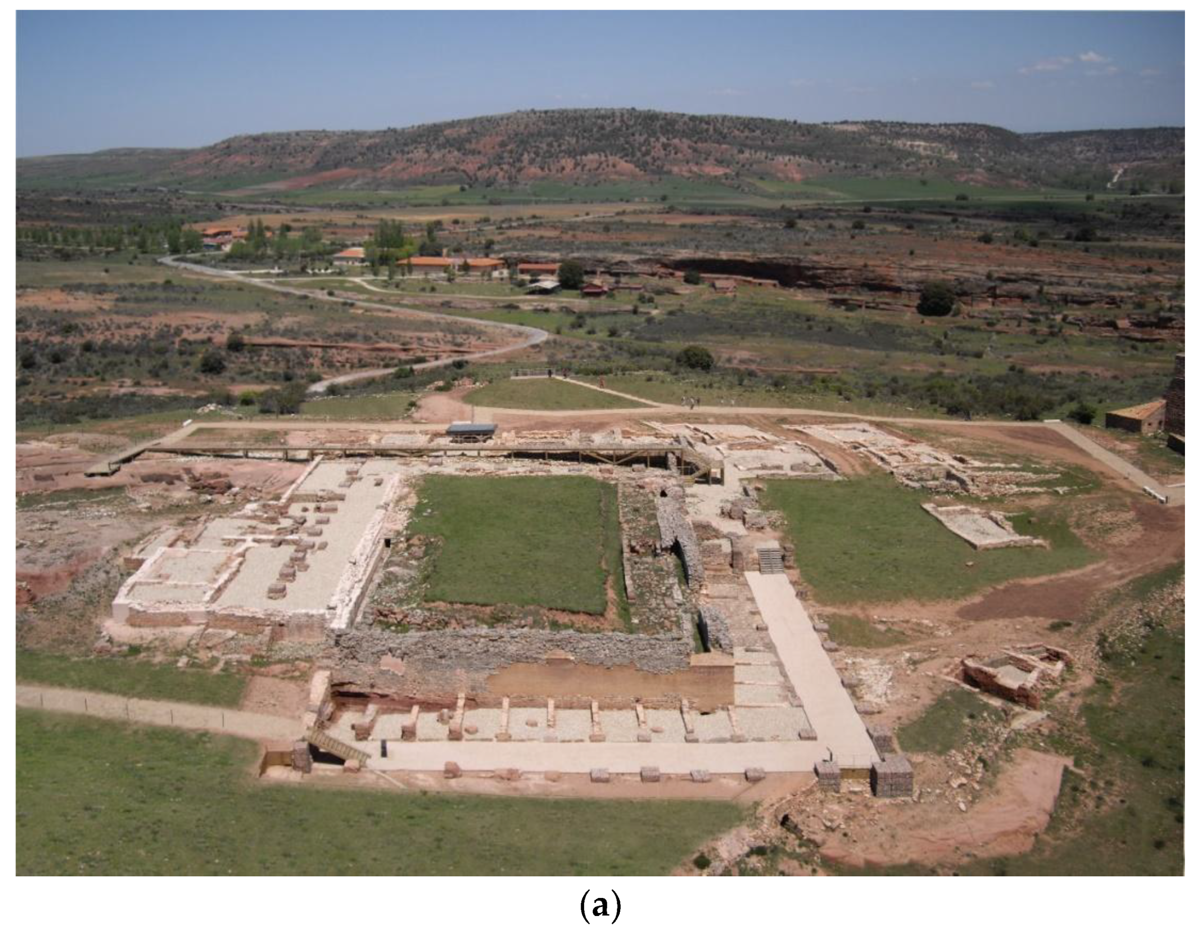
The course of action has focused on understanding the Celtiberian-Roman city and its most important archaeological sites (the Roman Forum and the so-called House of the Aqueduct) at two different levels (
Figure 2). On the one hand, the heritage remains have been integrated into the site, explaining them to the visitor from the landscape itself: accesses, views, singular points, external relationships, profiles, geometry, materials, topography, etc. On the other hand, it has intervened directly on the remains themselves in order to allow a spatial understanding of them, superimposing a new geometry, which, with clear, reversible, and constructively compatible elements, would be able to facilitate the observation of the elements of interest, helping to understand their architectural implantation on the hill.
2.2. Theoretical Classes: Case Studies and Analysis of Previous Experiences
As explained in the introduction, there is no single solution that reconciles accessibility and heritage, so it is important to analyse different cases and understand them from a site-specific perspective. More and more work is being carried out in the field of information design, but in many cases partial solutions are sought for a segment of the population, in an attempt to minimise the on-site impact. In other cases, in order to resolve accessibility issues, the solutions that have been offered are non-inclusive or very bulky and not very sensitive to the place where they are installed.
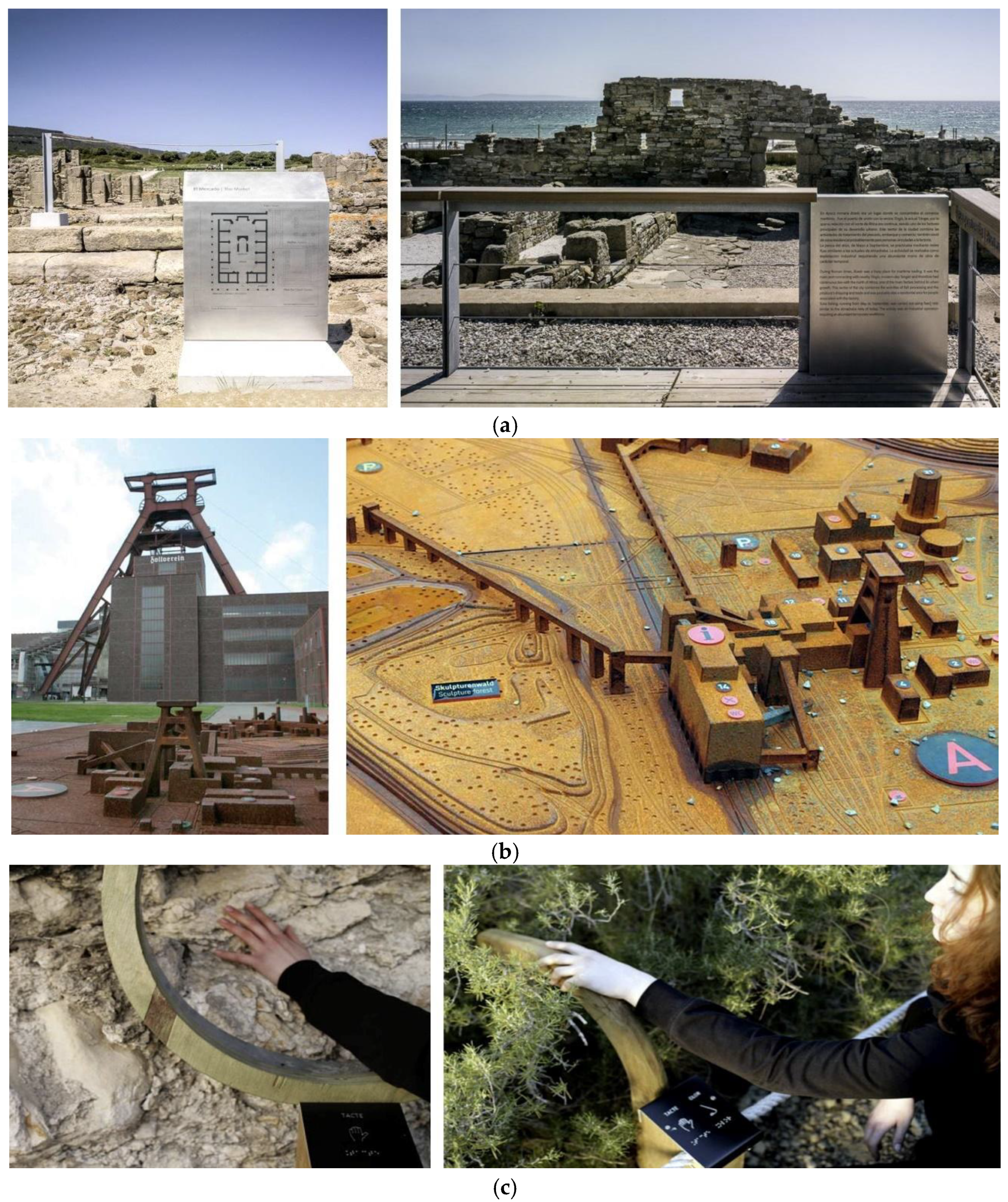
Therefore, the methodology that has been followed began with informal theoretical classes, where some case studies of projects in heritage landscapes, which pay attention to inclusive design, were shown. The success and failure of information design solutions were analysed out loud and students were prompted to reflect on other examples, which could be shared within the group in subsequent sessions. Projects from natural to architectural, ancient to industrial heritage were analysed, considering different approaches to information access: sensory or cognitive, and even the use of digital media in situ. To cite some of the examples given, Roman Site of Baelo Claudia, Cádiz, Spain; Zeche Zollverein Site, Essen, Germany; and the Garraf Natural Park, Sitges, Spain (
Figure 3). They all show that there is no one-size-fits-all approach to information design in heritage landscapes and that it is sometimes challenging to find the desired balance. The Roman site of Baelo Claudia illustrates this: it is an emblematic landscape and heritage intervention project, potentially prizewinning, whose interventions carried out inside the site are exemplary in terms of the interpretation of the ruins and have led to the formalisation of a new visitor itinerary that allows a correct reading of the urban fabric and deepens the knowledge of the city. In addition, it also forms an accessible circuit that allows a correct visualisation and understanding of the Roman city [
17] (p. 27). Yet the design of the information, and particularly the descriptive signage, were solved by paying more attention to heritage and less to accessibility, prioritizing coherence with the intervention, elegance of signage, and non-invasion of the site. Even if the integration of the information and orientation elements with the architectural elements and the use of the materials chosen for the signage are considered a success, it is sufficient to observe the height of the informative texts in which the information is placed to support this statement. On the other hand, the case of the Zollverain Area is exemplary; preservation through conversion is the principle used in what was once the largest and most productive mine in Germany’s Ruhr district. As a witness to the industrial past, an icon of industrial culture and a symbol of structural change, the site has been the subject of a proposed transformation in the cultural park which started in 2001 and was completed in 2010 by OMA [
18] (p. 51). This example is chosen because it counts on a very comprehensive wayfinding system, which includes brochures, signage (directories, information signs visible from afar and close up, and orientation signs on the ground), and large-scale models in the three zones into which the site is divided, which greatly facilitate orientation. This case shows how a proper wayfinding system, even without being designed under the parameters of inclusive design, can significantly improve the accessibility of the site. In particular, the use of large-scale models facilitates orientation for everyone: children, adults, and people with cognitive disabilities. Finally, the example of the Garraf Natural Park, although different from the previous ones in that it is a natural heritage site, invites us to reflect on how the sensory appreciation of the values of a place can be enhanced by means of simple devices designed specifically for this purpose [
19].
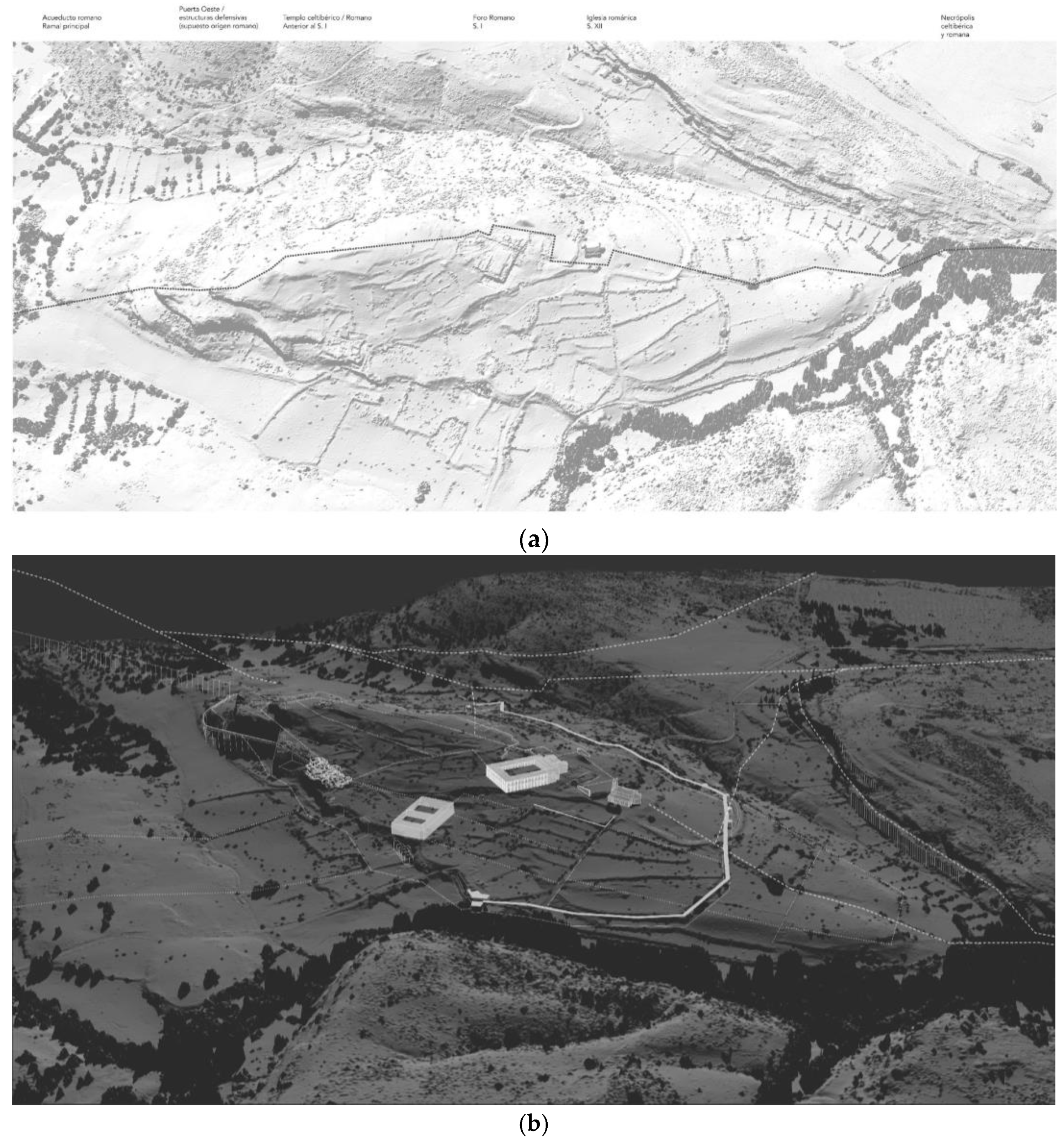
The work proposed to the students focuses on a heritage site such as Tiermes, where LAB/PAP has already carried out previous studies and projects, so that they can explain and provide basic information about the work carried out by the architects in collaboration with the archaeologists, and as explained above, show the interpretation given to the existing ruins. In general, complete data and certainties are not available, as there still are unexamined areas, and statements are often based on hypotheses (
Figure 4a–c). For this reason, the information is somewhat changeable; it is modified and expanded the more data become available.
To complete the process from research and intervention to knowledge transfer, two complementary lines of work have been implemented within the LAB/PAP. The first one focuses on the creation of physical and digital three-dimensional models, aerial photographs, and explanatory videos of Tiermes as audiovisual pills that allow us to comprehend the site. On the other hand, the signage design gathers all these materials to be provided to the visitor during the on-site visit to Tiermes, with the aim of improving the experience of visiting the site. Since 2018, the concern for universal design and sensory and cognitive accessibility has gained weight in the LAB/PAP, requesting a Research and Development and Innovation (R&D&I) project in 2020 and being included as another condition in the developed projects, complementing the pre-existing line of work regarding physical accessibility. It is time to update, from this point of view, the way in which we present our heritage landscapes.
2.3. Fieldwork: Direct Knowledge of the Heritage Landscape
Both in working with the students and in the subsequent development of their projects, the idea that a true understanding of a heritage element is only possible by interpreting the environment to which it belongs has been promoted. Although today’s digital media offer a range of possibilities of familiarising oneself with heritage landscapes without the need to visit them, it cannot be denied that direct knowledge definitely enhances our understanding and enjoyment. Some values, such as scale, proportion, or materiality, can only be truly appreciated by experiencing them in situ.
This idea is supported by the concept of "situated learning" [
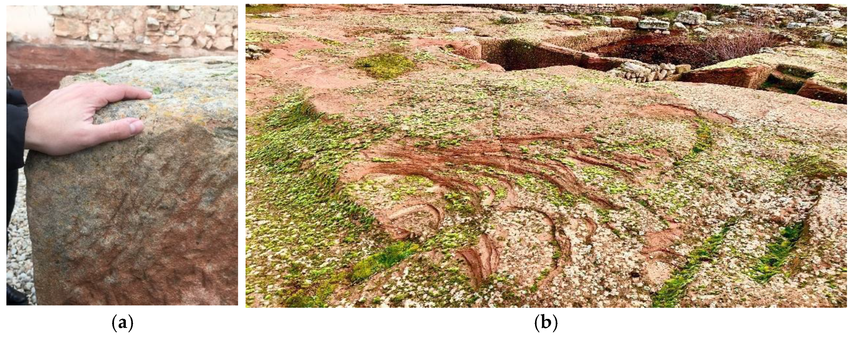
20]. According to this concept, the interpretation of a cultural heritage site is more effective when it is placed in its real context, thus giving a unique social and cultural value to the visit. Based on this concept, as soon as the opportunity arose, the students were taken to Tiermes where they developed their project about information design, trying to promote multisensory perception through smells, sounds, wind, haptic appreciation of materials, consideration of time, etc. For instance, they were asked to explore some of the fragments with their eyes closed, to enhance the sensory experience and to better understand the tactile qualities of the materials and the power of the wind at the site. This personal and sensory experimentation helps to deepen their research and enriches their projects (
Figure 5).
2.4. Workshop for Discussion, Supervision, and Testing
Final projects at the University of Valladolid are usually developed with a lecturer who regularly supervises the student’s work. However, one of the most important aspects in order to achieve the abovementioned objectives methodologically is to replace this individual tutoring with collective tutoring with discussion, supervision, and verification workshops.
The first sessions are designed to familiarise students with the topic of the work. They are based on the students’ search for examples to be analysed out loud and for possible elements of information to develop. During these meetings, discussion is encouraged among students in order to define how to brief each individual project. As the students develop their work, periodic sessions are held to supervise their progression. Students will carry on producing drawings, working models, and 3D prototypes, while studying accessibility and inclusive design regulations and recommendations.
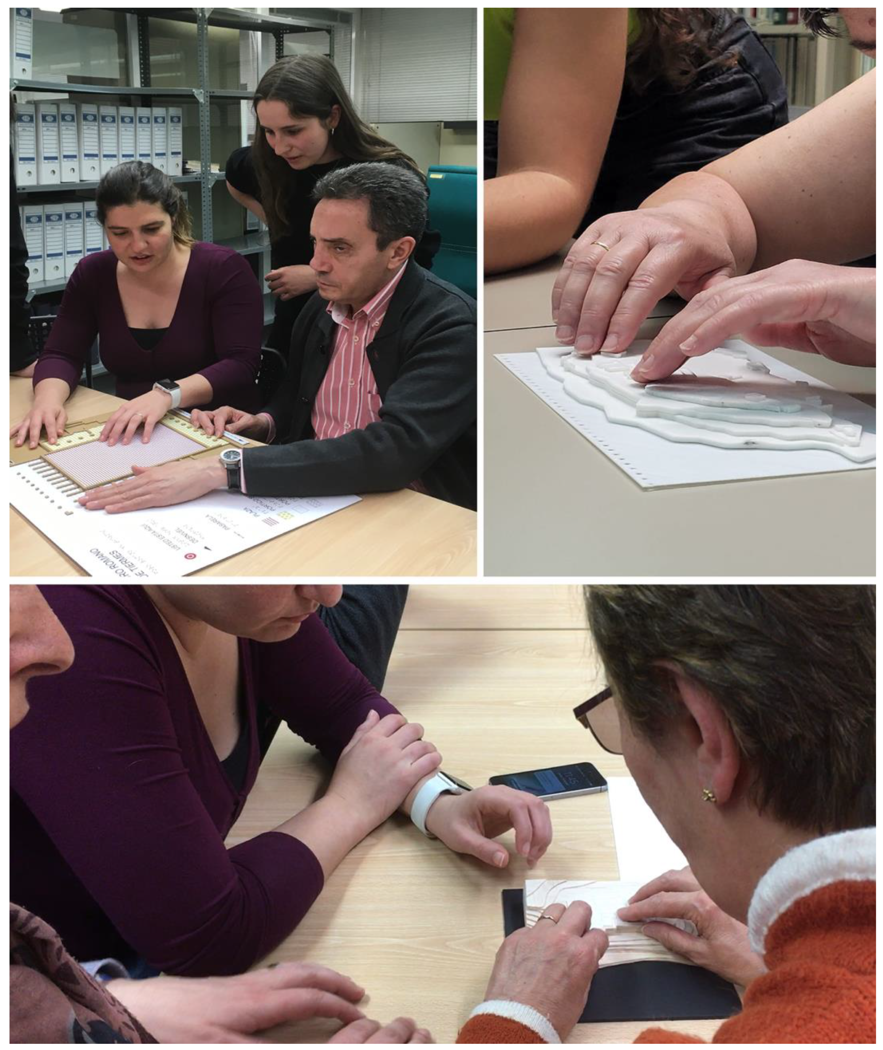
In some verification sessions, models are tested with users in an experimental workshop carried out in collaboration with ONCE, Spanish Organization of the Blind, with blind users or users with low vision, which allows relevant conclusions to be drawn for their assignments, such as the convenience of using ICT and tactile elements in a complementary way, depending on whether the information is ephemeral or permanent; the existence of the concept of tactile saturation, i.e., not abusing the use of textures wherever it can be avoided, in the case of tactile models or plans, and the convenience of using relief and not recesses in the designs (
Figure 6).
3. Results
As mentioned above, one of the main challenges for the research and dissemination of the
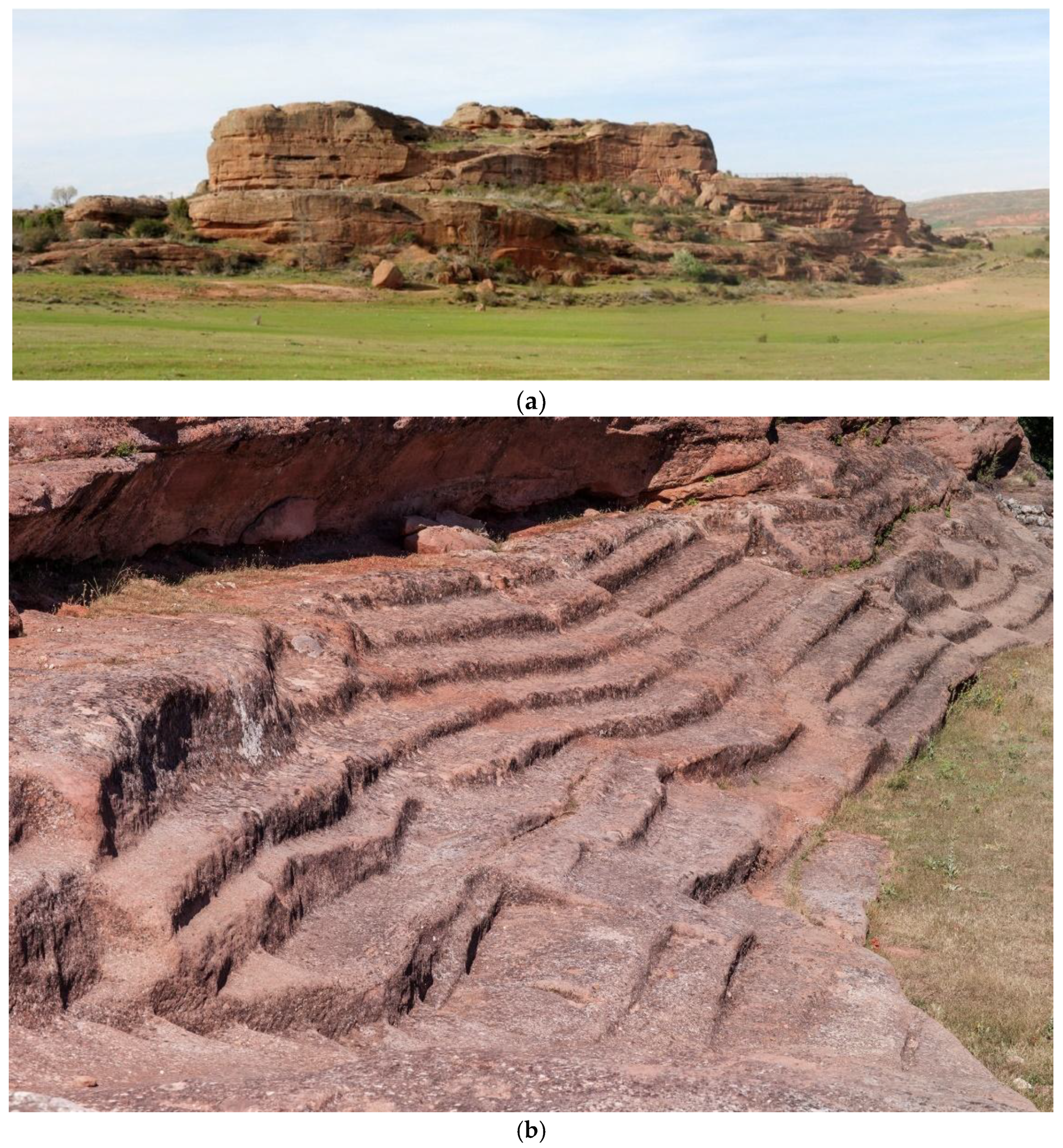
Tiermes Laboratorio Cultural is to explain and make understandable the artificial topography that shapes and characterises its landscape. The topographical relief that has been preserved to the present day is the result of a geological formation with differential erosion that, on the one hand, has given shape to the characteristic rocky terraces on which the city’s acropolis was built and, on the other hand, has led to the intense occupation of these terraces in their three dimensions, with constructions that have left archaeological traces and remains, in most cases as elements dug into the rock itself. This double condition is reflected in the current topography of Tiermes, the result of the natural landscape and of the landscape anthropised or modified by man, mainly in Roman times, whose constructions have altered the rocky contours, with cuts, fissures, and excavations, and in most cases still showing a strong geometric condition, clearly showing that it was a human settlement (
Figure 7).
Although all the architectural actions carried out by LAB/PAP in Tiermes have been aimed at improving the accessibility and understanding of the site, the research group also believes that the design of the information can further improve the understanding of the site and open it up to a greater number of users. Therefore, some teachers and researchers from this group worked using the described methodology with a team of students to develop their Bachelor’s Degree Final Project, all with the aim of making the information as inclusive as possible and promoting the different parts of the site, as well as its identity and uniqueness, to a wider audience. In this way, some goals or lines of work were established and a weekly tutorial was conceived as a workshop in which these projects were discussed, coordinated, and enriched by lecturers and group support, as explained before. Five proposals are introduced below, which present different approaches to this question.
3.1. General Tactile Model of Tiermes on a Large Scale
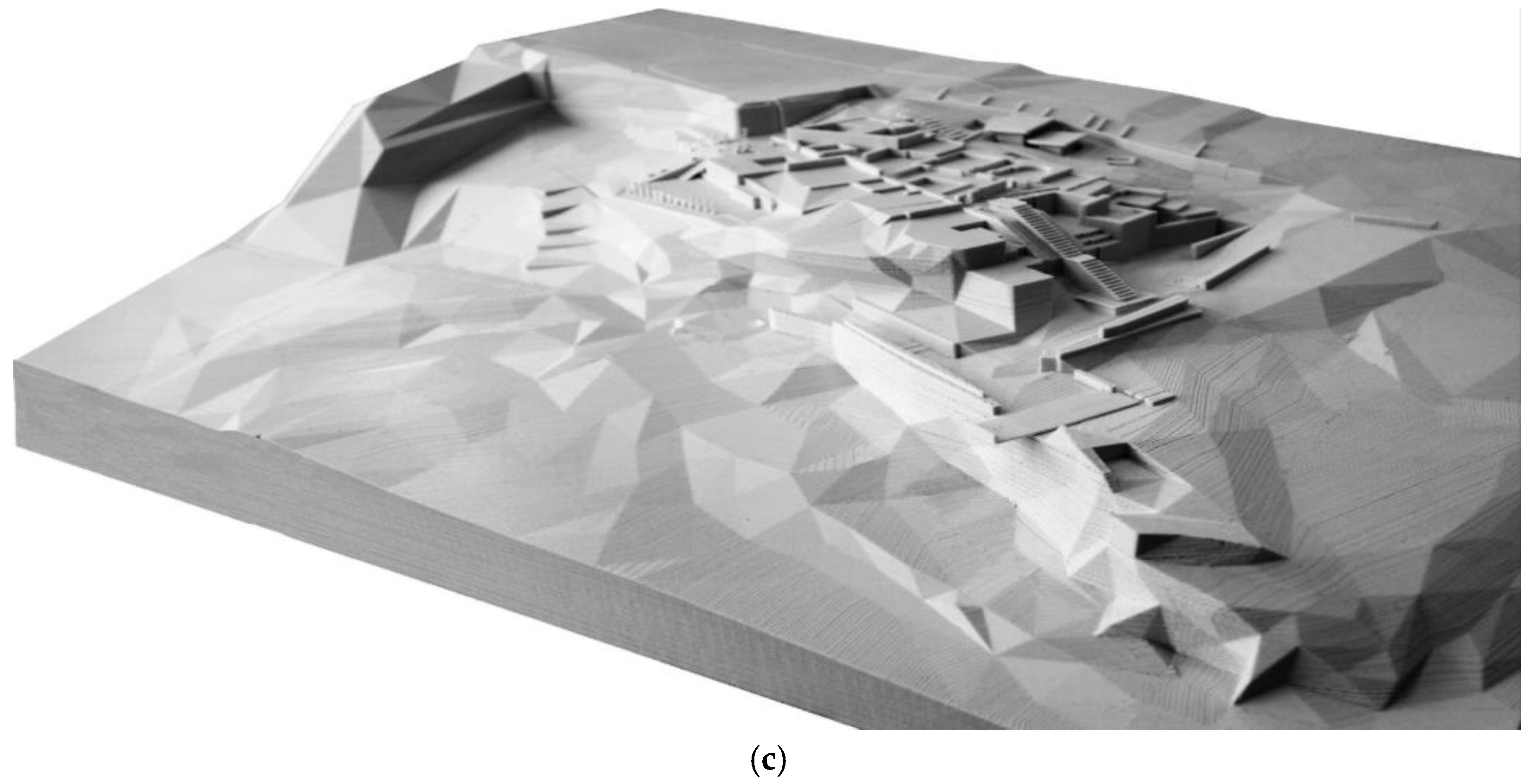
The general understanding of the topography of Tiermes represents one of the great challenges due to its extension and complexity. One of the proposals aimed to synthesise the landscape of Tiermes through a complete model of the archaeological area, measuring 1500 mm × 755 mm, which on the one hand reflects the significant topographical unevenness of more than 40 m (between 1200 and 1240 m altitude) in the four main platforms of the city, and on the other hand locates and represents the main archaeological remains present in some areas [
21] (
Figure 8).
In order to further comprehend the artificial topography of Tiermes, lecturers reinforced two complementary levels of information to understand the landscape of Tiermes which had already been revealed in the graphic representation systems established for the architectural intervention projects developed in the site by LAB/PAP: the large scale of the topography and the architecture of certain complexes, such as the Forum, the Thermal Baths, and the residential complexes on the southern front. The general topography is constructed from contour lines, simplified, and arranged to clearly explain the large vertical cliffs, built from CNC laser-cut wooden planks. The archaeological remains are built from 3D digital printing models with PLA plastic in white, whose technology allows the pieces to be defined with greater precision, hence being able to depict the volume of the characteristic walls and platforms of these archaeologies.
The advantage of working with this double material condition, for topography and archaeology, is that it allows the places where the most obvious archaeological sites are located to be clearly identified within the larger landscape. These points are also marked in contrast of colour and numbers, in relief and Braille, with references to a general legend, located at the bottom of the model.
3.2. Portable and Tactile Model for Tiermes
The pronounced orography of Tiermes also entails very important orientation problems when visiting. The design of a portable model becomes a great opportunity to facilitate the general understanding of the site and the specific orientation of visitors along the route, offering a lightweight material that follows the criteria of universal design, as it is both a visual and tactile device, trying to meet the needs of the greatest number of people through the use of a single object.
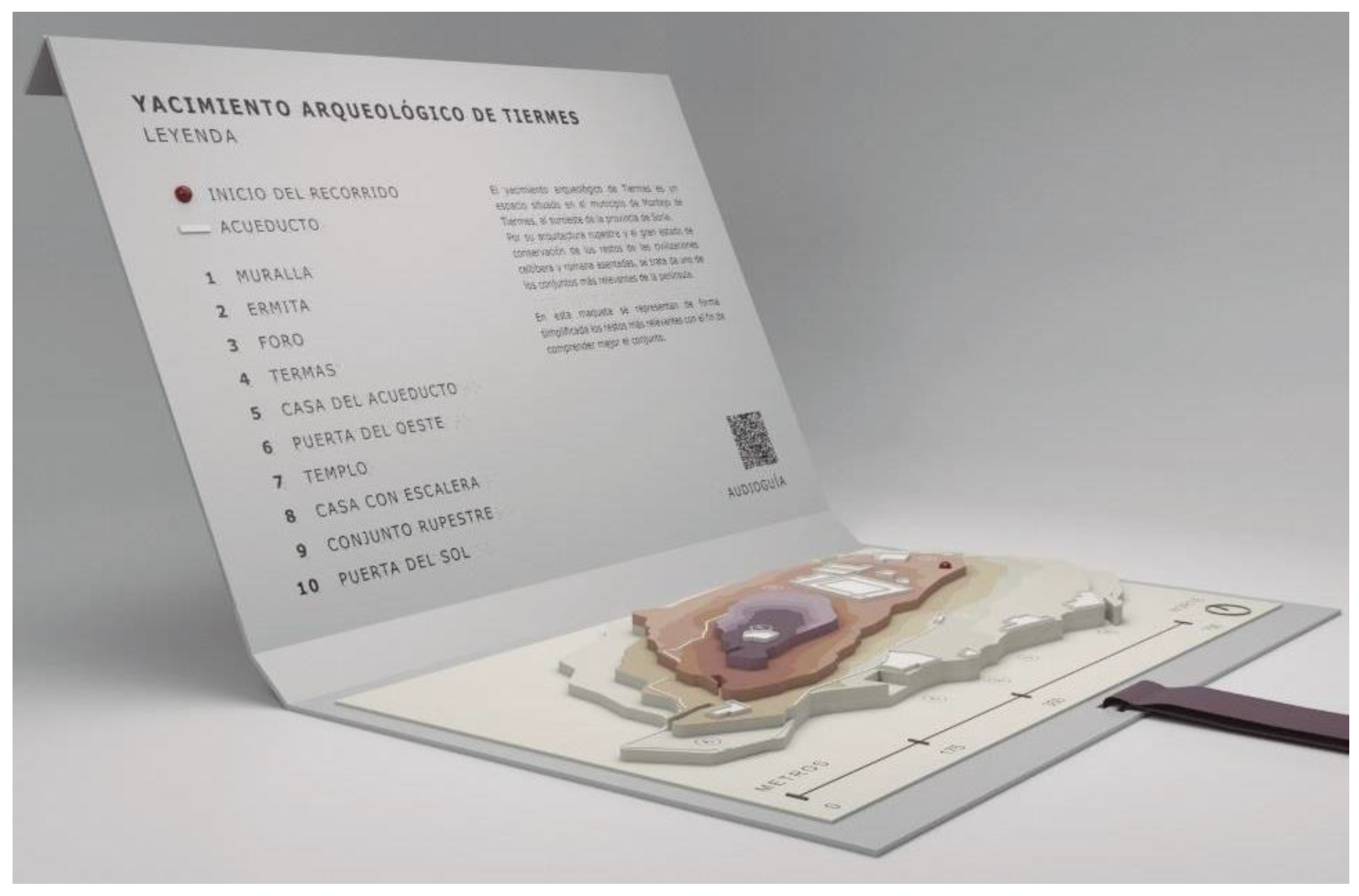
The model synthetically represents the topography of the Roman city through the four main platforms that comprise it, using different colours that follow a clear progression as the height increases, helping to understand the orography of Tiermes in a more intuitive way. On the other hand, the main archaeological remains are shown in relief and in white to present maximum contrast, which facilitates their identification. The product, designed by Minerva Vega, has a ribbon so that it can be hung around the neck to leave both hands free during transport or movement, which is highly important to make it easier for visitors to walk around the site [
22]. The model is protected inside a light box measuring 265 × 176.5 × 18 mm, which wraps around itself and is closed with a magnet, duplicating, when open, the surface on which the information and legend can be placed, which is provided both in visual alphabet and Braille (
Figure 9).
3.3. Signage with Tactile Maps
Another line of work that has been developed in Tiermes focuses on the design of an inclusive signage system for the Roman Forum, to continue the work launched by LAB/PAP, and make the visit more comprehensive and accessible in order to reach the greatest number of people.
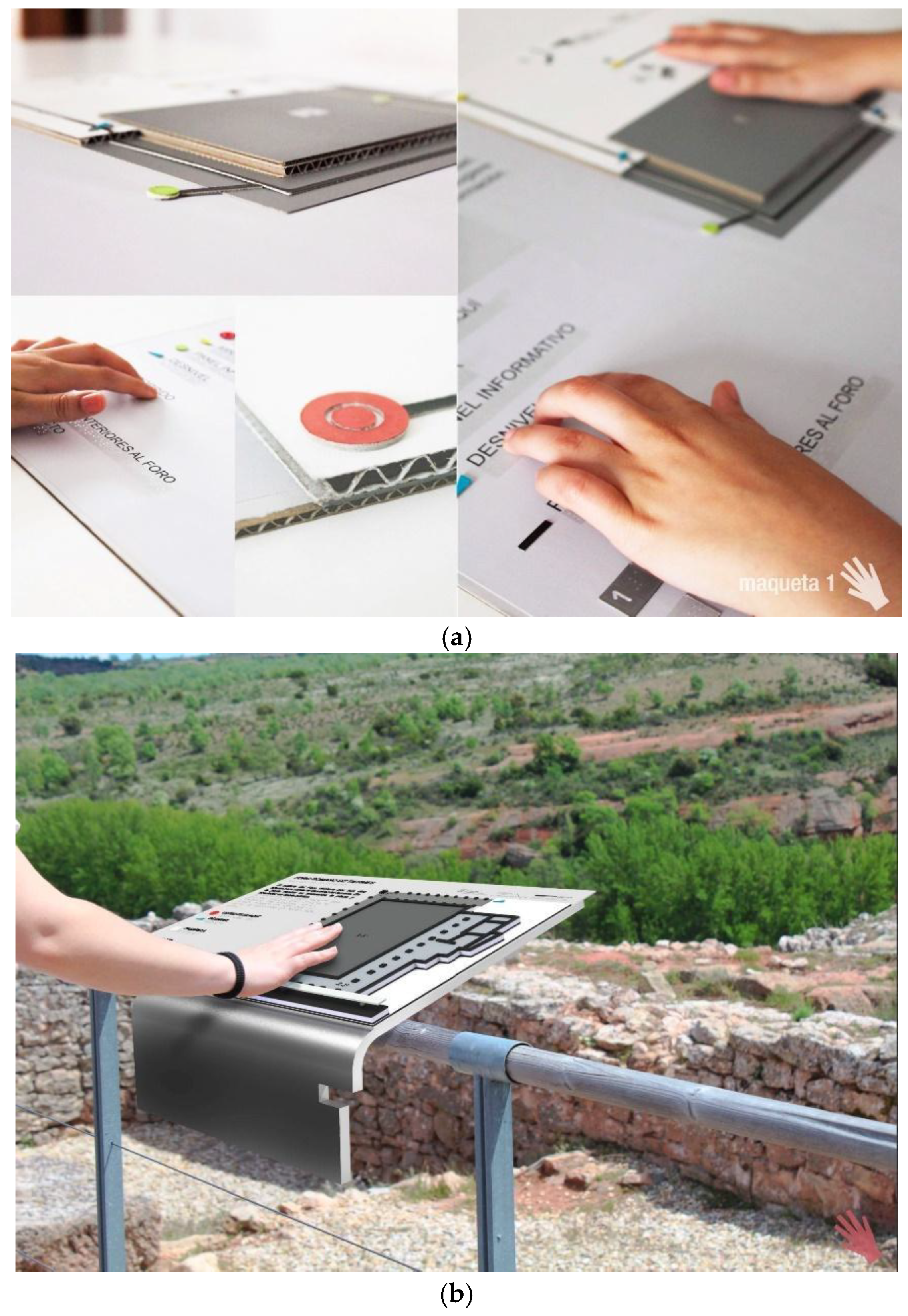
The signs designed by María Pérez are the result, on the one hand, of the essentialisation of the main forms that structure the archaeological remains guided by the experience of the professors, authors of the current signage of the site within LAB/PAP, and, on the other, of experimentation with textures and symbols in relief that make it possible to provide the necessary information at the point along the route where it is easiest to understand [
23]. They form a single family, both in terms of the design of the representation codes and the layout of the information on the panel, and in terms of the support system, which is capable of adapting to different situations by means of variations on the same solution. The panels are located at four strategic points marked on the ground, and invite the visitor to pause during the tour, which is organised to provide information ranging from the general to the specific (
Figure 10).
The first sign sets the visitor in context and presents the general route, the most important elements, and their location in relation to the immediate surroundings. The second sign, located on the walkway of the Roman Forum, shows the plan of the building in relief as it is preserved today, and gives precise information on the main elements of which it is composed. The third sign shows the elevation that opens out onto the landscape, so that the scale of the building and its composition can be understood. This information is complemented by the final experimental point, which presents one of the original pieces that composed the structure of the building, facilitating its tactile exploration.
3.4. Windows into the Past
The proposal Windows into the Past, developed by Laura Junco [
24], aims to carry out a work of interpretation and accessibility to cultural heritage, from a quasi-artistic approach; in the understanding of Marc Auge: “The contemplation of ruins allows us to catch a fleeting glimpse of the existence of a time that is not the one about which history books speak or the one that restoration works try to resuscitate… It is a lost time whose recovery is the task of art” [
25] (p. 7). The purpose is to give the visitors an idea of what it would have been like to be in the ancient city of Tiermes, visualizing the elevations of the volumes and architectural structures of the place in a simple and interactive way, making the users feel as if they were walking through the streets of Tiermes or entering its buildings. It links the line of work of volumetric and virtual reconstruction of the ancient city of Tiermes initiated by LAB/PAP and the objective of transferring the information to the place where it is most useful. Although it was initially planned to install a series of signs on the place, using transparent methacrylate panels on which the volumes of the most representative buildings would be drawn, it was finally decided to use a much more accessible, economical, and manageable format: a brochure that would facilitate the understanding of the ancient city and allow an individual use, less invasive for the site (
Figure 11).
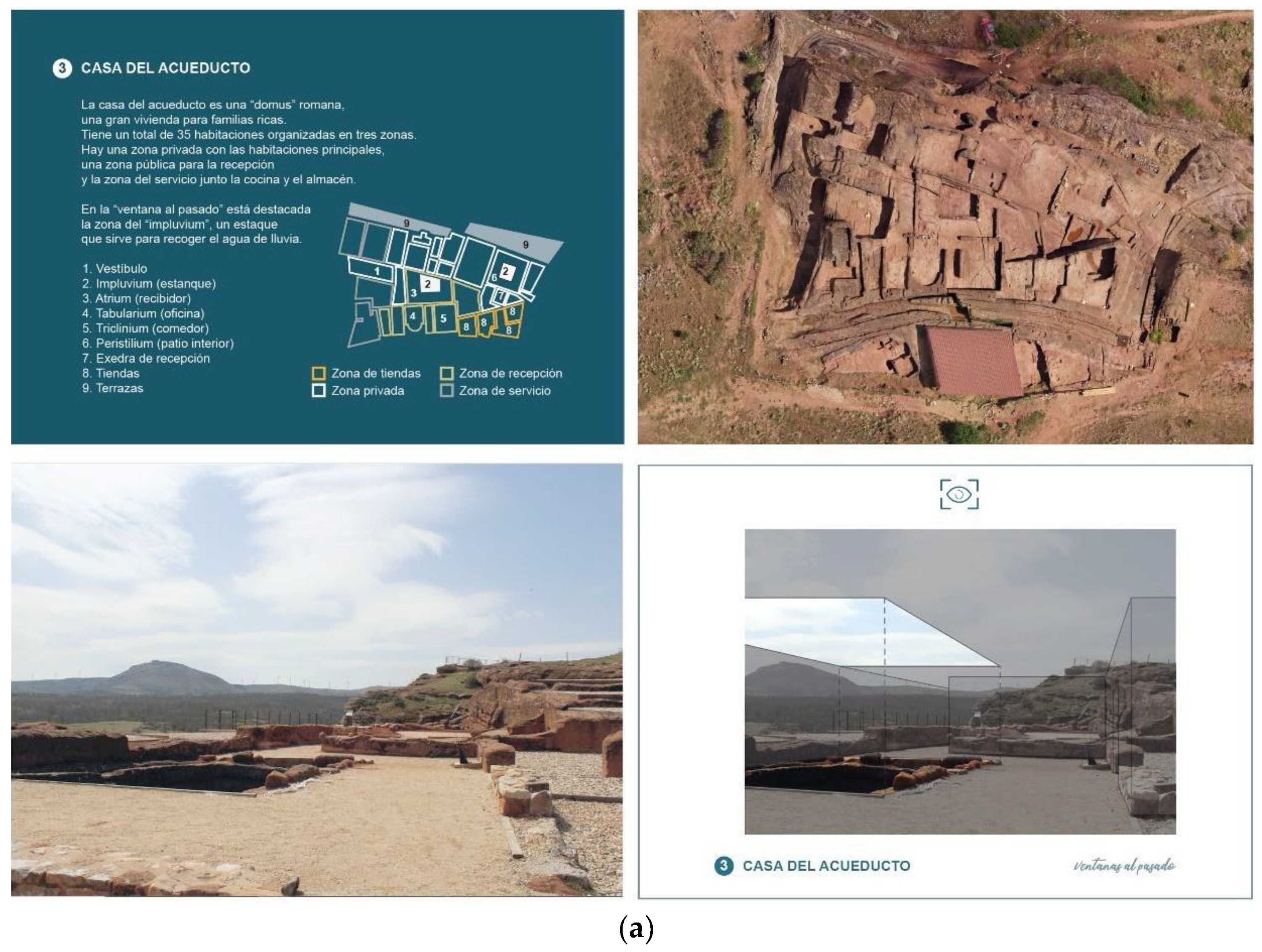
Thus, some portable frames or windows are used, which make up an interactive brochure with a certain playful character, with the aim of bringing the site closer to different users, being especially attractive for children. With the intention of making it accessible to as many people as possible, the explanatory texts that can be found with the windows follow the guidelines of Easy Reading, so that people with cognitive disabilities can read them. The idea of presenting clear and understandable text for such an audience, with particular attention to content, language, layout, and illustrations, will undoubtedly make it easier for more users, including children and the elderly. Accompanying the brochure are a series of signs on the ground showing the user where to stand and where to look. An attempt was made to include easily identifiable elements in the selection of the views that would make up the brochure. The result is a selection of six "windows into the past" which are marked on the plan of the current route. In addition, instructions are included on a sheet, with intuitive text and icons, so that it can be easily used by everyone.
The brochure begins with brief general information about Tiermes, and then indicates the general itinerary, the way the booklet works, and the six
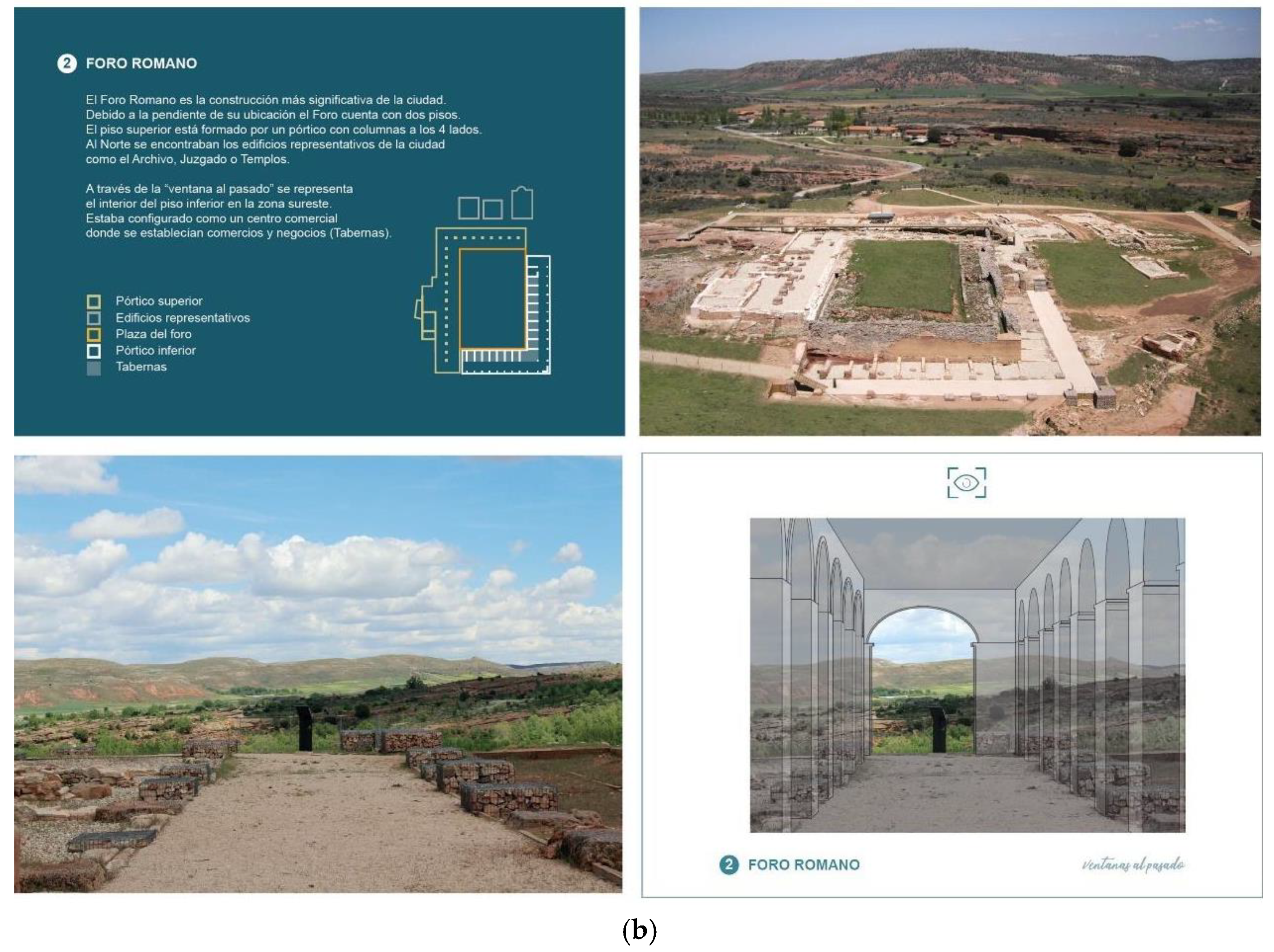
windows into the past that have been chosen, each of which will be explored later. They have been strictly designed to follow the same order and layout. A brief description, floor plan, and aerial photograph are provided for each window. The frame is then accompanied by a photograph of the acetate drawing, which is intended to give the user an idea of the volumetric dimensions of the space they are looking at, of which today only a few ruins can be seen on the site. For example, in one
window, which corresponds to the
Casa del Acueducto, the purpose is to make the visitors feel that they are inside the domus. In the window to the past of this building, the interior of the house can be seen from the reception area, highlighting the
impluvium with its opening to the sky, the main element of the space. Another
window is dedicated to the Roman Forum and takes the user to the lower floor in the south-eastern area, which was configured as a commercial centre where, as explained above, there were shops and business areas, closed rooms called
Tabernae (
Figure 12).
3.5. Wayfinding App for Tiermes
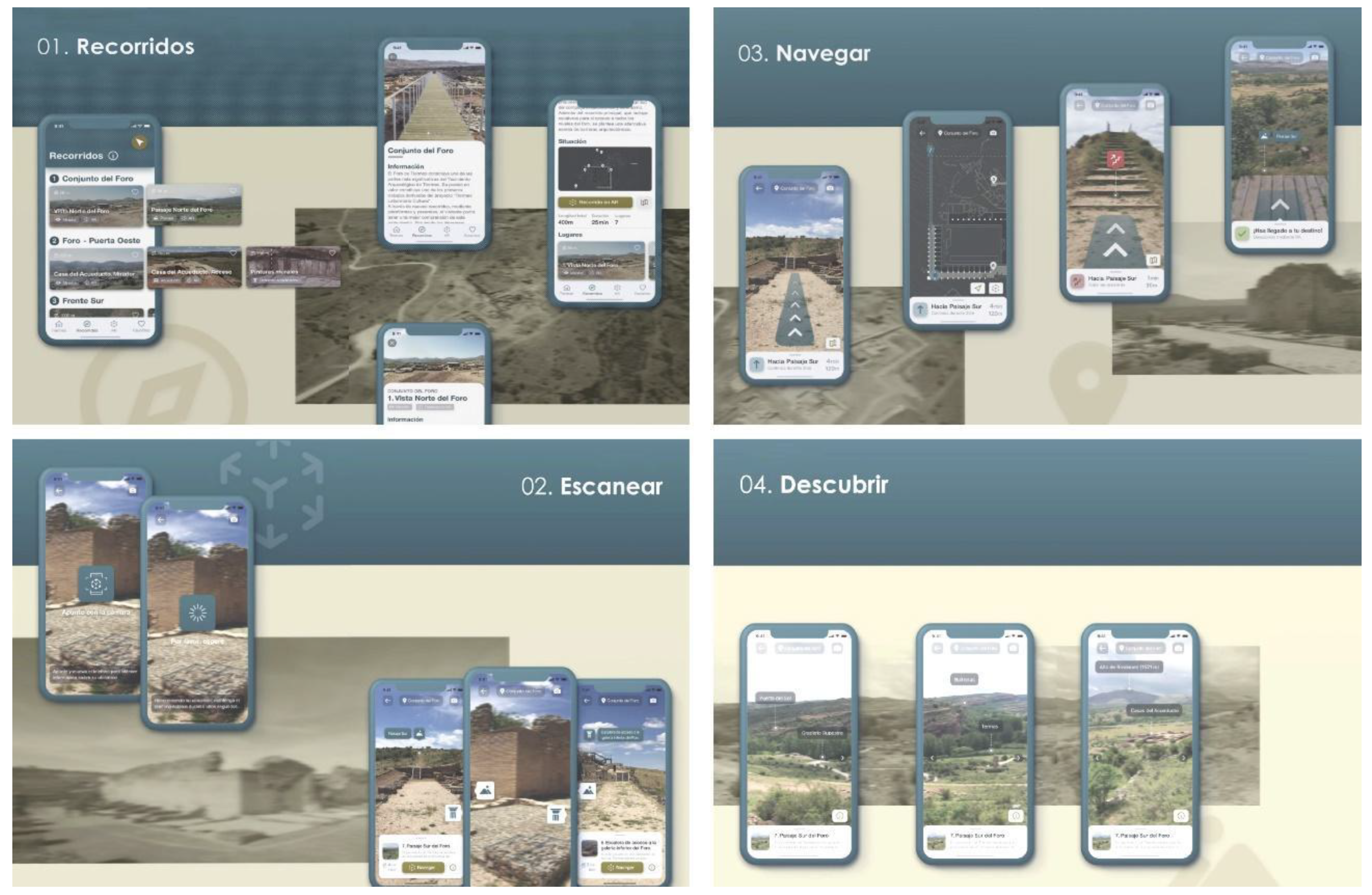
This proposal takes another step forward in designing information for the Tiermes archaeological site recommending a mobile augmented reality application for the site, with the aim of increasing knowledge, making it accessible, and encouraging user participation [
26]. Thus, the designed phone application aims to improve the user experience, guiding and orienting the visitor (wayfinding), and discovering the heritage assets through augmented reality experiences.
Carlos Matilla’s application aims to complement the information already provided by the signage along the route and is therefore designed with the same corporate identity. It offers four main functions: tour, scan, navigate, and explore. The first one proposes a visit to Tiermes in a fragmented way, dividing the general route into four partial itineraries, organised around the most relevant constructions or infrastructures of the ancient city. The first itinerary begins at the Roman Forum, on the north side of the hill. The second route starts from the Forum and continues westwards along the city’s roads and paths to the Casa del Acueducto and then to the Puerta del Oeste (Western Gate), the westernmost point and one of the main entrances to the city. The third itinerary takes the visitor down through the Puerta del Oeste to the Frente Sur, the group of cave constructions on the southern edge of the site. The last one includes a visit to the Graderío Rupestre, rock-cut grandstands, and the Puerta del Sol (Sun Gate).
The second function proposed by the application, scanning, aims to enable the application to detect the user’s location and provide information about it and the objects of interest within reach. The third function, navigation, uses augmented reality to show the visitor the route to follow. It also gives the orientation, distance, and approximate time of the route to be followed, and can alternate with the visualisation of the map of the site if desired. The final feature, explore, uses geolocation to identify points of interest on the surrounding landscape, from which information can be obtained (
Figure 13).
4. Discussion
Once the different proposals have been described, a critical and realistic analysis should be made of which information systems are most useful and accessible so that they can be implemented at the site. As is evident, the approach of each design is completely different from the rest, supporting the starting point that no one-size-fits-all approach is feasible. Full accessibility to cultural heritage is not always realistic. Wherever possible, however, the aesthetic enjoyment produced by direct artistic experience should be facilitated through touch and the other senses, bringing closer beauty and harmony of three-dimensional forms and complementing them with appropriate accessible multi-sensory information. The following analysis of the various proposals is therefore made from this perspective.
The creation of a global tactile model is considered to be very useful to obtain global information about the site in the first place. In general, a tactile model is useful to provide basic information and to understand the scale of the site and its different elements. Like the large-scale models of the Zollverein wayfinding system shown above, it is useful for people with cognitive disabilities, children, the elderly, etc. In this case, it has been designed to be tactile as well, making it as inclusive as possible. But if this object can be helpful in any place, in the case of Tiermes, it is not only useful but almost essential, given its characteristics, since both its large size and its material homogeneity make it generally difficult to find one’s way around. For this reason, it was decided that the first action to be taken would be to start work on a complete model of the archaeological area, measuring 1500 mm × 755 mm, which will be placed in the archaeological museum at the site to welcome visitors before they start their tour.
Given the complexity of the site and the difficulty of remembering all the information, it is also considered a great help if the user can carry a portable model to guide him along the route. This object could be taken out of the museum and returned to it at the end of the visit. It will be prototyped and probably implemented with more information at key points along the route, such as texts in Easy Reading, as suggested in the Windows into the Past project. To begin with, Plena Inclusión organization and some people with cognitive disabilities have already collaborated in the testing of the texts, in order to ensure their correct adaptation. It is possible that, in the future, these easy-to-read texts will also accompany the current signs, either directly or by means of a QR code, and that some of the signs will have tactile elements, as suggested in the proposal for the Forum.
On the other hand, it is necessary to be aware of the fact that new technologies have become an ally in the dissemination and understanding of cultural heritage, bringing it closer to society. In this context, new interactive experiences can be created in a non-invasive way using tools such as smartphone applications or augmented reality. But they depend on devices, batteries, and a good network, which is not always available in Tiermes, so in some ways they are less accessible.
The brochure "Windows into the Past", although more limited in its functionalities, can be considered as a “low cost” virtual reality. Although it is also very attractive because of its playful character, its more limited scope makes it less inclusive, so it is postponed for the time being. However, it has been considered that the use of technology could be useful for people with physical disabilities or elderly people who may find it difficult to complete the entire route, especially in areas with steep slopes such as the Puerta Oeste. In this sense, a possible future line of work is the creation of a virtual tour, similar to the one created by LAB/PAP in the Museum of African Art of the University of Valladolid [
27], with easy-to-read descriptions in English and Spanish, understood as an accessibility measure that allows those who cannot visit the place to know it virtually.
Possibly with more limited functions than those offered by the application shown above, the virtual tour would be aimed more at non-in situ use. Although the proposal for the mobile phone application is very well designed, really complete, and extremely attractive and intuitive, and could certainly be successful in the future, it is felt that the characteristics of the site should be emphasised by the physical experience, promoting as much as possible a sensory experience without excessive digital distractions: feeling the texture of the stone, the force of the wind, the variations in light, the sensation of changing scale depending on where you are in the site, etc.—in other words, enhancing not only the knowledge but also the landscape values of this incredible place.
The table below offers a summary of the information design proposals for Tiermes, with their main characteristics, and the measures that need to be modified or implemented in order to carry them out in the future, with the aim of reaching as many people as possible, so that they can be truly inclusive (
Table 1).
The following words, by the Finnish architect Juhani Pallasmaa, underline the importance of building for the senses, which should always be at the basis of architects and designers work, enabling a better understood and more accessible environment:
"The authenticity of architectural experience is grounded in the tectonic language of building and the comprehensibility of the act of construction to the senses.
We behold, touch, listen and measure the world with our entire bodily existence, and the experiential world becomes organised and articulated around the centre of the body" [
28] (p. 64).
