Accessibility of Geoheritage Sites—A Methodological Proposal
Abstract
:1. Introduction
2. Method Proposal
2.1. Evaluation Criteria
2.2. Scoring System
3. Method Application
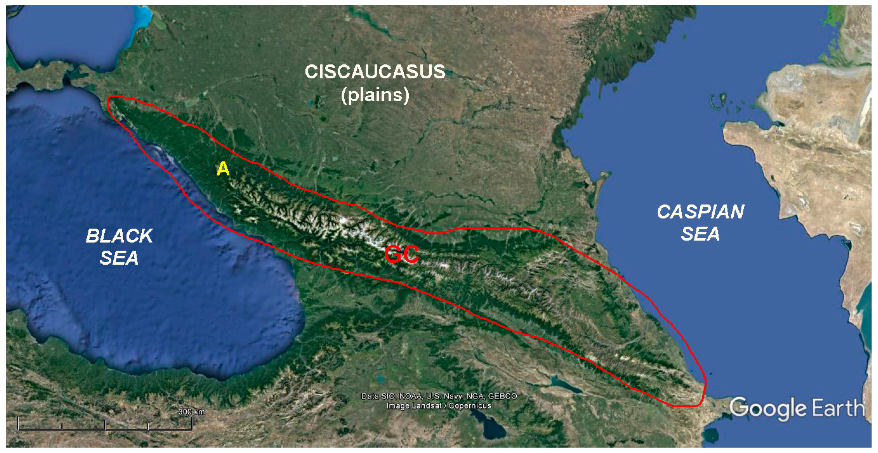
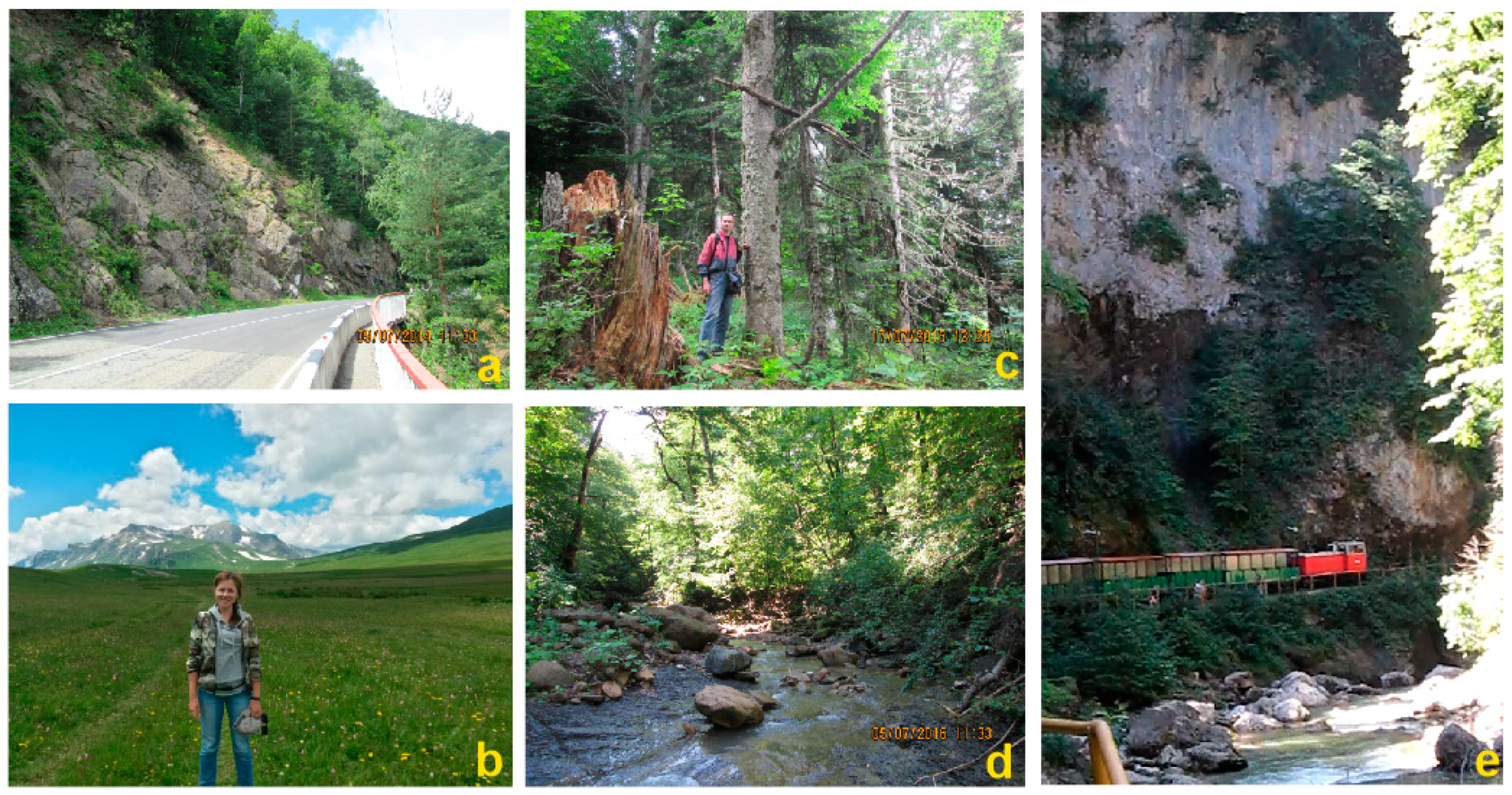
3.1. Geosite Accessibility in Mountainous Adygeya
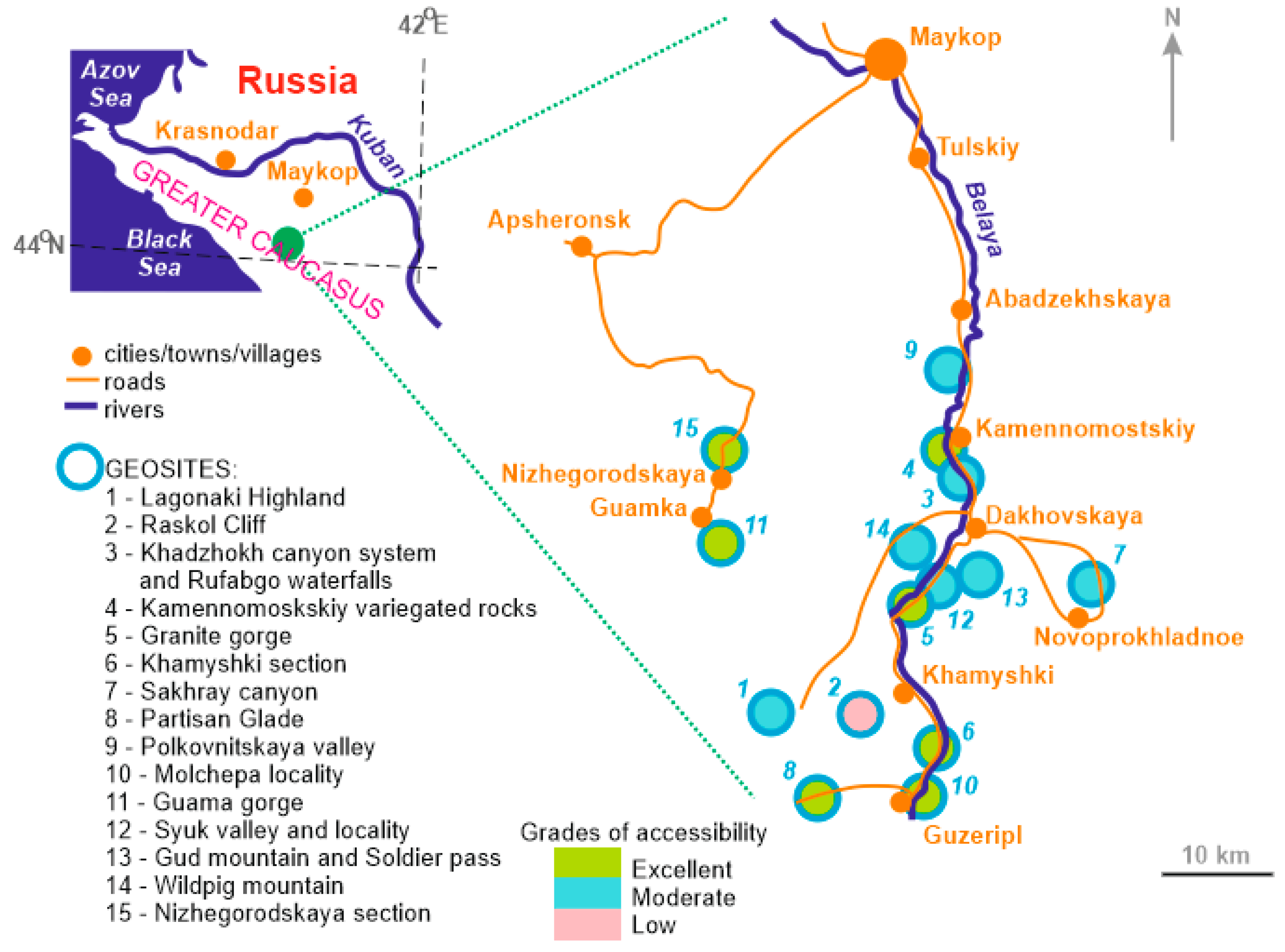
3.2. Spatial Heterogeneity of Geosite Accessibility
4. Discussion and Conclusions
Author Contributions
Funding
Institutional Review Board Statement
Informed Consent Statement
Data Availability Statement
Acknowledgments
Conflicts of Interest
References
- Brilha, J. Inventory and quantitative assessment of geosites and geodiversity sites: A review. Geoheritage 2016, 8, 119–134. [Google Scholar] [CrossRef] [Green Version]
- Pereira, P.; Pereira, D.; Alves, M. The geomorphological heritage approach in protected areas: Geoconservation vs. Geotourism in Portuguese natural parks. Mem. Descr. Della Carta Geol. D’Italia 2009, 87, 135–144. [Google Scholar]
- Prosser, C.; Murphy, M.; Larwood, J. Geological Conservation: A Guide to Good Practice; English Nature: Peterborough, UK, 2006. [Google Scholar]
- Reynard, E.; Brilha, J. (Eds.) Geoheritage: Assessment, Protection, and Management; Elsevier: Amsterdam, The Netherlands, 2018. [Google Scholar]
- Ruban, D.A. Quantification of geodiversity and its loss. Proc. Geol. Assoc. 2010, 121, 326–333. [Google Scholar] [CrossRef]
- Štrba, L.; Rybar, P.; Balaz, B.; Molokac, M.; Hvizdak, L.; Krsak, B.; Lukac, M.; Muchova, L.; Tometzova, D.; Ferencikova, J. Geosite assessments: Comparison of methods and results. Curr. Issues Tour. 2015, 18, 496–510. [Google Scholar] [CrossRef]
- Zwoliński, Z.; Stachowiak, J. Geodiversity map of the Tatra National Park for geotourism. Quaest. Geogr. 2012, 31, 99–107. [Google Scholar] [CrossRef] [Green Version]
- Ferreira, A.R.R.; Lobo, H.A.S.; de Jesus Perinotto, J.A. Inventory and Quantification of Geosites in the State Tourist Park of Alto Ribeira (PETAR, São Paulo State, Brazil). Geoheritage 2019, 11, 783–792. [Google Scholar] [CrossRef]
- Armiero, V.; Lirer, L.; Petrosino, P. The Solfatara: Volcanological survey and proposal of institution of a Geosite in Campi Flegrei. Rend. Della Soc. Geol. Ital. 2007, 5, 3–30. [Google Scholar]
- Coratza, P.; Vandelli, V.; Fiorentini, L.; Paliaga, G.; Faccini, F. Bridging terrestrial and marine geoheritage: Assessing geosites in Portofino Natural Park (Italy). Water 2019, 11, 2112. [Google Scholar] [CrossRef] [Green Version]
- Migoń, P.; Pijet-Migoń, E. Overlooked Geomorphological Component of Volcanic Geoheritage—Diversity and Perspectives for Tourism Industry, Pogórze Kaczawskie Region, SW Poland. Geoheritage 2016, 8, 333–350. [Google Scholar] [CrossRef]
- Pinińska, J.; Domonik, A.; Dziedzic, A.; Łukasiak, D. The methodology of a complex engineering-geological approach to establish a geopark: Case study of the Małopolska Wisła River Gorge. Geol. Q. 2014, 59, 408–418. [Google Scholar] [CrossRef] [Green Version]
- Lima, E.A.; Machado, M.; Ponte, J. Geological heritage management: Monitoring the Azores geopark geosites. Comun. Geol. 2014, 101, 1295–1298. [Google Scholar]
- Vegas, J.; Díez-Herrero, A. An Assessment Method for Urban Geoheritage as a Model for Environmental Awareness and Geotourism (Segovia, Spain). Geoheritage 2021, 13, 27. [Google Scholar] [CrossRef]
- Kubalíkova, L.; Drápela, E.; Kirchner, K.; Bajer, A.; Balková, M.; Kuda, F. Urban geotourism and geoconservation: Is it possible to find a balance? Environ. Sci. Policy 2021, 121, 1–10. [Google Scholar] [CrossRef]
- Warowna, J.; Zgłobicki, W.; Kołodyńska-Gawrysiak, R.; Gajek, G.; Gawrysiak, L.; Telecka, M. Geotourist values of loess geoheritage within the planned Geopark Małopolska Vistula River Gap, E Poland. Quat. Int. 2016, 399, 46–57. [Google Scholar] [CrossRef]
- Migoń, P.; Pijet-Migoń, E. Viewpoint geosites—Values, conservation and management issues. Proc. Geol. Assoc. 2017, 128, 511–522. [Google Scholar] [CrossRef]
- Migoń, P.; Różycka, M. When individual geosites matter less—Challenges to communicate landscape evolution of a complex morphostructure (Orlické–Bystrzyckie mountains block, Czechia/Poland, Central Europe). Geosciences 2021, 11, 100. [Google Scholar] [CrossRef]
- Mikhailenko, A.V.; Ruban, D.A. Environment of Viewpoint Geosites: Evidence from the Western Caucasus. Land 2019, 8, 93. [Google Scholar] [CrossRef] [Green Version]
- Lima, A.; Nunes, J.C.; Brilha, J. Monitoring of the Visitors Impact at “Ponta da Ferraria e Pico das Camarinhas” Geosite (São Miguel Island, Azores UNESCO Global Geopark, Portugal). Geoheritage 2017, 9, 495–503. [Google Scholar] [CrossRef] [Green Version]
- Jin, Q.; Ruban, D.A. A conceptual framework of tourism crowding management at geological heritage sites. Nat. Nascosta 2011, 43, 1–17. [Google Scholar]
- Began, M.; Višnic, T.; Djokic, M.; Vasiljevic, D.A. Interpretation Possibilites of Geoheritage in Southeastern Serbia—Gorge and Canyon Study. Geoheritage 2017, 9, 237–249. [Google Scholar] [CrossRef]
- Bruno, B.C.; Wallace, A. Interpretive Panels for Geoheritage Sites: Guidelines for Design and Evaluation. Geoheritage 2019, 11, 1315–1323. [Google Scholar] [CrossRef]
- Ivlieva, O.V.; Shmytkova, A.V.; Sukhov, R.I.; Kushnir, K.V.; Grigorenko, T.N. Assessing the tourist and recreational potential in the South of Russia. E3S Web Conf. 2020, 208, 05013. [Google Scholar] [CrossRef]
- Adamia, S.; Zakariadze, G.; Chkhotua, T.; Sadradze, N.; Tsereteli, N.; Chabukiani, A.; Gventsadze, A. Geology of the Caucasus: A review. Turk. J. Earth Sci. 2011, 20, 489–544. [Google Scholar]
- Ismail-Zadeh, A.; Adamia, S.; Chabukiani, A.; Chelidze, T.; Cloetingh, S.; Floyd, M.; Gorshkov, A.; Gvishiani, A.; Ismail-Zadeh, T.; Kaban, M.K.; et al. Geodynamics, seismicity, and seismic hazards of the Caucasus. Earth Sci. Rev. 2020, 207, 103222. [Google Scholar] [CrossRef]
- Kaban, M.K.; Gvishiani, A.; Sidorov, R.; Oshchenko, A.; Krasnoperov, R.I. Structure and density of sedimentary basins in the southern part of the east-European platform and surrounding area. Appl. Sci. 2021, 11, 512. [Google Scholar] [CrossRef]
- Trifonov, V.G.; Sokolov, S.Y.; Sokolov, S.A.; Hessami, K. Mesozoic–Cenozoic Structure of the Black Sea–Caucasus–Caspian Region and Its Relationships with the Upper Mantle Structure. Geotectonics 2020, 54, 331–355. [Google Scholar] [CrossRef]
- Van Hinsbergen, D.J.J.; Torsvik, T.H.; Schmid, S.M.; Matenco, L.C.; Maffione, M.; Vissers, R.L.M.; Gürer, D.; Spakman, W. Orogenic architecture of the Mediterranean region and kinematic reconstruction of its tectonic evolution since the Triassic. Gondwana Res. 2020, 81, 79–229. [Google Scholar] [CrossRef]
- Drápela, E.; Bohác, A.; Böhm, H.; Zágoršek, K. Motivation and preferences of visitors in the Bohemian Paradise UNESCO global geopark. Geosciences 2021, 11, 116. [Google Scholar] [CrossRef]
- Baláž, B.; Štrba, L.; Lukác, M.; Drevko, S. Geopark development in the Slovak republic–alternative possibilities. Int. Multidiscip. Sci. GeoConf. Surv. Geol. Min. Ecol. Manag. 2014, 2, 313–320. [Google Scholar]
- Cayla, N. An Overview of New Technologies Applied to the Management of Geoheritage. Geoheritage 2014, 6, 91–102. [Google Scholar] [CrossRef]
- Chu, T.-H.; Lin, M.-L.; Chang, C.-H. mGuiding (Mobile Guiding)-Using a Mobile GIS app for Guiding. Scand. J. Hosp. Tour. 2012, 12, 269–283. [Google Scholar] [CrossRef]
- Filocamo, F.; Di Paola, G.; Mastrobuono, L.; Rosskopf, C.M. MoGeo, a mobile application to promote geotourism in Molise region (Southern Italy). Resources 2020, 9, 31. [Google Scholar] [CrossRef] [Green Version]
- Pica, A.; Reynard, E.; Grangier, L.; Kaiser, C.; Ghiraldi, L.; Perotti, L.; Del Monte, M. GeoGuides, Urban Geotourism Offer Powered by Mobile Application Technology. Geoheritage 2018, 10, 311–326. [Google Scholar] [CrossRef]
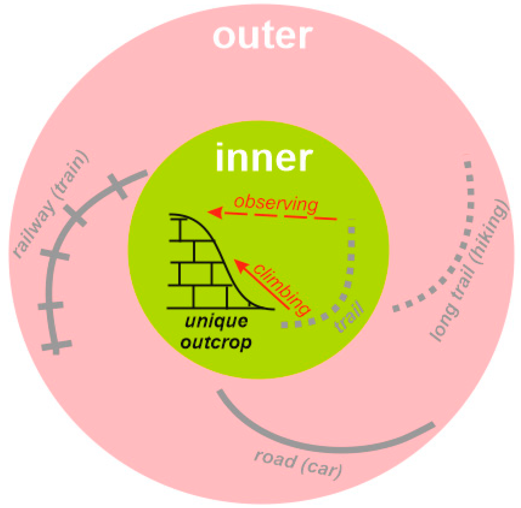
| Inner Accessibility | Outer Accessibility | |||
|---|---|---|---|---|
| State | Scores | State | Scores | |
| Unlimited Access | 10 | Public Transport (Bus, Train, etc.) Available | 10 | |
| High-Quality Road (Unlimited Access by Cars and Excursion Buses) | 7 | |||
| Training Required for Access, Distant Observation Possible | 5 | Poor-Quality Road (Restricted Access by Selected Cars) | 5 | |
| Well-Established Trail (Unlimited Access by Hiking, <1 h) | 5 | |||
| Well-Established Trail (Unlimited Access by Hiking, >1 h) | 3 | |||
| Training Required for Access, Distant Observation Impossible | 1 | Ephemeral Trail (Access by Trained Hikers) | 1 | |
| Observation from Remote Viewpoint | 1 | |||
| Location in Remote and Wild Place | 0 | |||
| Entrance fee/required permission | −3 | |||
| TOTAL | from 0 to 20 | |||
| Grades of accessibility | ||||
| Excellent | >15 | |||
| Moderate | from 7 to 15 | |||
| Low | <7 | |||
| Geosite (Figure 2) | Unique Features | Geosite Value | Accessibility | |||
|---|---|---|---|---|---|---|
| Inner | Outer | Fee | Total | |||
| 1 | Late Jurassic carbonate platform, reefs, and fossils, modern karst, panoramic views | Global | 1–10 (av. 5) | 7 | −3 | 9 |
| 2 | Late Permian reefs | Global | 5 | 0 | 0 | 5 |
| 3 | canyons and klamm, Triassic sequences, chevron folds, waterfalls, megaclasts | National | 1–10 (av. 5) | 10 | −3 | 12 |
| 4 | Late Jurassic sabkha outcrops | National | 10 | 10 | 0 | 20 |
| 5 | Precambrian metamorphic rocks, Early Paleozoic serpentinites, Late Paleozoic granitoids | National | 10 | 10 | 0 | 20 |
| 6 | Permian molasse, Jurassic outcrops | National | 10 | 10 | 0 | 20 |
| 7 | Triassic sequences, tectonic dislocations, waterfalls | Regional | 5 | 5 | 0 | 10 |
| 8 | Early–Middle Jurassic dark shales, tectonic dislocations, panoramic views | Regional | 10 | 7 | 0 | 17 |
| 9 | Mid-Cretaceous green sandstones, gigantic ammonites | Regional | 5 | 5 | −3 | 7 |
| 10 | Early Jurassic ichnofossils, geoarchaeological site | Regional | 10 | 10 | −3 | 17 |
| 11 | natural and artificial landforms, Late Jurassic limestones | Regional | 10 | 10 | 0 | 20 |
| 12 | Early–Middle Jurassic dark shales, tectonic dislocations, fossil invertebrates | Local | 5 | 10 | 0 | 15 |
| 13 | isolated mountain, Middle Jurassic sequences, panoramic views | Local | 1–10 (av. 5) | 1–10 (av. 5) | 0 | 10 |
| 14 | isolated mountain, Middle Jurassic crinoid limestones, gigantic bivalves | Local | 5 | 5 | 0 | 10 |
| 15 | Fuabginskaya Formation reference section | Local | 10 | 10 | 0 | 20 |
Publisher’s Note: MDPI stays neutral with regard to jurisdictional claims in published maps and institutional affiliations. |
© 2021 by the authors. Licensee MDPI, Basel, Switzerland. This article is an open access article distributed under the terms and conditions of the Creative Commons Attribution (CC BY) license (https://creativecommons.org/licenses/by/4.0/).
Share and Cite
Mikhailenko, A.V.; Ruban, D.A.; Ermolaev, V.A. Accessibility of Geoheritage Sites—A Methodological Proposal. Heritage 2021, 4, 1080-1091. https://doi.org/10.3390/heritage4030060
Mikhailenko AV, Ruban DA, Ermolaev VA. Accessibility of Geoheritage Sites—A Methodological Proposal. Heritage. 2021; 4(3):1080-1091. https://doi.org/10.3390/heritage4030060
Chicago/Turabian StyleMikhailenko, Anna V., Dmitry A. Ruban, and Vladimir A. Ermolaev. 2021. "Accessibility of Geoheritage Sites—A Methodological Proposal" Heritage 4, no. 3: 1080-1091. https://doi.org/10.3390/heritage4030060
APA StyleMikhailenko, A. V., Ruban, D. A., & Ermolaev, V. A. (2021). Accessibility of Geoheritage Sites—A Methodological Proposal. Heritage, 4(3), 1080-1091. https://doi.org/10.3390/heritage4030060


