Review

Granite Landscapes, Geodiversity and Geoheritage—Global Context

Institute of Geography and Regional Development, University of Wrocław, pl. Uniwersytecki 1, 50-137 Wrocław, Poland
Heritage 2021, 4(1), 198-219; https://doi.org/10.3390/heritage4010012
Submission received: 31 December 2020 / Revised: 10 January 2021 / Accepted: 11 January 2021 / Published: 18 January 2021

Abstract

:
Granite geomorphological sceneries are important components of global geoheritage, but international awareness of their significance seems insufficient. Based on existing literature, ten distinctive types of relief are identified, along with several sub-types, and an overview of medium-size and minor landforms characteristic for granite terrains is provided. Collectively, they tell stories about landscape evolution and environmental changes over geological timescale, having also considerable aesthetic values in many cases. Nevertheless, representation of granite landscapes and landforms on the UNESCO World Heritage List and within the UNESCO Global Geopark network is relatively scarce and only a few properties have been awarded World Heritage status in recognition of their scientific value or unique scenery. Much more often, reasons for inscription resided elsewhere, in biodiversity or cultural heritage values, despite very high geomorphological significance. To facilitate future global comparative analysis a framework is proposed that can be used for this purpose.

Graphical Abstract

1. Introduction

Geoheritage is variously defined in scholarly literature, but notwithstanding rather subtle differences there is a general agreement that is refers to elements of the Earth’s geodiversity that are considered to have significant scientific, educational, cultural or aesthetic value and are therefore subject to conservation and management [1,2]. Geodiversity, in turn, means the natural range of geological (rocks, minerals, fossils), geomorphological (landform, processes), hydrological and soil features [3]. There have been numerous attempts to express geodiversity numerically, to have measures allowing for comparisons between different regions and to facilitate parallel evaluation of multiple localities so that conservation priorities could be established [4]. Thus, these two terms are clearly linked and geodiversity assessment may inform about the value of geoheritage, but it would be incorrect to equal geoheritage of considerable significance with high level of geodiversity. This is because singular elements of geoheritage may be considered of very high significance, scientific or other, whereas the area where they sit may actually show rather limited range of geological and geomorphological features [5]. On the other hand, however, high geodiversity is usually the result of either high complexity of processes involved in shaping particular terrains, even if they occurred over rather brief time intervals (such as in depositional terrains of the last ice-sheet glaciation), or protracted geological and geomorphological evolution that left extensive rock record and multi-layered landform palimpsest. Consequently, high geodiversity areas are likely to represent geoheritage of significant value. It is also argued that conservation and management of geoheritage is most effectively implemented at the geosite level, that is at individual localities representing rock and sediment outcrops, specific landforms or hydrological features [6]. Focus on geosite inventory and development for general public is particularly evident in geoparks, both UNESCO Global Geoparks and variously defined national geoparks in different countries, which by definition should represent geoheritage of considerable significance [7]. However, geoheritage is more than the sum of geosites. Its evaluation should be based on accumulated scientific knowledge about an area, compared with both adjacent areas and those more distant ones, but having broadly similar features within their territories.
Defining the value of geoheritage and thresholds of significance at various levels (global/international, regional, national, and local) is challenging, especially if one realizes that different values may be considered. Two approaches may be identified, evident in proposals of geosite evaluation. One considers different values simultaneously and applies weightings to them, arriving at the final score that aggregates scientific significance with other reasons for significance [8,9,10,11,12,13]. Another one disassociates evaluation of scientific value from purpose-made evaluations, aimed at selection of localities best suited to develop geo-educational activities or tourism in general [14]. In each approach the core problem is the selection of indicators, followed by defining criteria for each indicator, and then weighting of indicators in the final evaluation, which altogether means that these seemingly quantitative approaches are still based on a number of arbitrary expert decisions and are region-specific rather than universally applicable. It is probably true that semi-quantitative evaluations may work fairly well at the local level, but are less suited to serve global comparative analysis.
Geoheritage is indeed evaluated at various spatial levels of reference, from very local (municipalities or other small administrative regions, geomorphological entities such as drainage basins) to global. The latter is directly relevant to two global initiatives aimed at conservation of heritage of international significance: UNESCO World Heritage [15] and UNESCO Global Geoparks [16]. The former is based on the World Heritage Convention that requires World Heritage properties to have “outstanding universal value” ([17], paragraph 77), whereas the latter defines “geological heritage of international value” [7] as a necessary attribute of a UNESCO Global Geopark. Examination of nomination files for UNESCO World Heritage, both ultimately successful and unsuccessful, shows that defining objective criteria to inform evaluation process has been difficult and the lack of good framework, translated into specific self-evaluation guidelines, is part of the problem. Although a general framework was proposed by Dingwall et al. [18] and recommended for use [19], its shortcomings were increasingly realized and in 2019–2020 a task group within IUCN (International Union for Conservation of Nature) was working on providing a new framework to evaluate geoheritage in the specific context of UNESCO World Heritage [20]. There were also more specific studies aimed to help future nomination processes, focused on volcanoes [21,22], karst [23], and deserts [24]. However, they obviously do not cover the full spectrum of geoheritage.
This paper aims to contribute to geoheritage and geodiversity assessment in the global context, providing a framework for erosional landscapes developed upon granites. “Erosional systems” are one of categories recognized by McKeever and Narbonne [20], but this is still a very broad term that requires refinement and clarification in respect to specific morphologies. Granite-supported sceneries are by no means trivial at the global scale, covering c. 15 per cent of the terrestrial surface [25]. At the same time, they represent an enormous variety and there is clearly no such phenomenon as a “typical” granite landscape. Some of these sceneries have long been appreciated for their outstanding beauty and awarded UNESCO World Heritage status, many others are valued at the national or regional level, featuring also on the Tentative List of possible future World Heritage nominations. Consequently, this paper has the following structure. First, diversity of granite landscapes will be presented using worldwide examples. Second, the current representation of granite-supported sceneries on the UNESCO World Heritage List will be discussed. Third, granite landscapes within UNESCO Global Geoparks will be briefly commented. Fourth, challenges and opportunities associated with recognizing geoheritage of granite terrains at the global level will be addressed, including provision of tentative framework and identification of gaps.

2. Diversity of Granite Landscapes

2.1. Justification of Approach

Geomorphological diversity can be presented at a variety of scales, reflecting hierarchical nature of landforms. Although geomorphological landscape (= type of relief) is a sum of medium-size landforms, an approach adopted here follows a top-down pathway and starts with presentation of distinctive types of regional relief, whereas more detailed characterization of certain specific landforms will follow. The latter will be restricted to those giving particular identity to granite terrains and considered to have values associated with geoheritage. This approach, in the context of UNESCO World Heritage, is justified by the realization that in respect to natural heritage the Convention is not designed for individual features of specific interest but for larger properties, which should meet important requirements of representativeness and integrity. The latter stipulates that the property includes all elements necessary to express its outstanding universal value and is of adequate size to ensure the complete representation of the features and properties which convey the property’s significance ([26], paragraph 88).

2.2. Granite Relief Types and What They Tell

Various approaches to classify granite landscapes can be found in literature [27,28,29,30], but it seems that the proposal of the present author [25] is the most elaborate and accounts for the global diversity. Accordingly, the following types of relief are recognized:
  • Plains;
  • Plains with residual hills;
  • Multi-convex topography;
  • Multi-concave topography;
  • Plateaus;
  • Dissected plateaus;
  • Undulating hilly lands;
  • Joint-valley topography;
  • All-slopes relief;
  • Stepped relief.

2.2.1. Plains

Plains are extensive tracts of level terrain, located close to the regional base level, with drainage lines in the level of the plain. Twidale [30] remarked that “plains are […] by far the most characteristic landforms developed on granitic rocks”, although quantitative data to support this statement seem not to be available. Plains are obviously not perfectly planar and may show minimal relief, but certainly lack incised valleys and upstanding relief features such as residual ridges, hills (inselbergs), and whalebacks. Plains are most characteristic in ancient shields, where they truncate Precambrian granites. Examples can be provided from interior Australia, the Namib Desert, parts of Sahara, as well as from Fennoscandia and Arctic and Sub-Arctic Canada [25,30,31]. Plains may be rock-cut or carry a thin veneer of residual deposit or weathering mantle. In more humid environments bedrock under the plain may be weathered to a depth of tens of metres, but if this is the case, plains become more and more undulated, with wide trough valleys and broad convex elevations [32]. The origin of plains used to be one of the key research questions in geomorphology, but the subject is considerably less explored nowadays. However, it seems accepted that perfect plains are much more likely to form under conditions of aridity and limited deep weathering [25], whereas glacial erosion exploiting surface-parallel joints may have helped to create extensive planar relief on formerly glaciated shield.

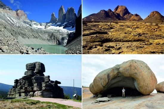
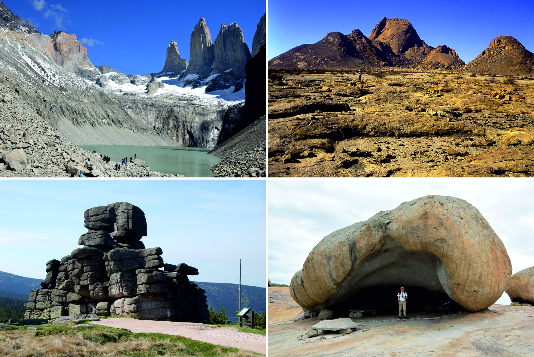
2.2.2. Plains with Residual Hills

Not all plains and gently undulated terrains are featureless. They may include isolated hills which often dramatically rise above the general planar surface, reaching heights in the order of hundreds of metres, with slopes locally >50° steep. These conspicuous residual elements are called inselbergs and are characteristic, well-visible landforms within many savanna, semi-desert, and desert landscapes, although their actual distribution is global and ranges from the tropical rainforests to high latitudes [30,33,34]. Less impressive elevations, less than 50 m high on average and with rather gentle slopes, are variously named as ruware, whalebacks, or shield inselbergs.
Inselbergs are among the most striking landforms globally, especially if they rise high above the plains, such as Spitzkoppe in the Namib Desert, nearly 700 m high (Figure 1). Specific shapes of inselbergs are mainly due to structural factors and reflect characteristics of jointing patterns. Consequently, morphological classification of inselbergs [25,34] is based on structure–form relationships and includes: (a) Domes, also known as bornhardts, developed on particularly massive bedrock compartments, with major penetrating joints few and widely spaced, but surface-parallel convex sheeting joints may be conspicuously present and guide the overall dome form; (b) castellated inselbergs of irregular shapes, controlled by intersecting vertical joints of variable orientation; and (c) boulder-strewn inselbergs or nubbins, which are apparently chaotic piles of loose boulders, supporting one another. The latter type may evolve from castellated inselbergs due to their ongoing subaerial weathering rock mass disintegration, or reflect irregular jointing pattern. In real landscapes all three morphological types of inselbergs may co-exist.
The debate on the origin of inselbergs was particularly hot in the 1960s [33,35,36,37,38]; see also [25,30] for subsequent summaries] and resolved in a predictable way that inselbergs may evolve along different pathways, with or without antecedent deep weathering. Examination of broader geomorphological, geological, and palaeoclimatic context usually helps to infer the most plausible scenario and inselbergs become significant carriers of information about long-term landscape evolution. At the same time, it has become clear that they are not “accidents” and do not form in random places, but reflect geological controls in both macro- and mesoscale, lithological and structural [39,40,41,42]. The development of cosmogenic isotope dating methods allowed one to constrain exposure ages and to infer long-term erosion rates of some spectacular granite inselbergs such as Spitzkoppe [43], providing most valuable insights into regional denudation patterns.

2.2.3. Multi-Convex Topography

Multi-convex relief was identified as a characteristic granite landscape by Thomas [28] who emphasized the occurrence of closely spaced and irregularly distributed hills, convex in outline and circular to oval in ground plan, often weathered throughout. Relative relief is in the order of 100 m and slopes are typically 20–25°. Bedrock is only locally exposed, usually in the form of protruding boulders or their clusters. Examples were provided from humid and seasonally humid low latitudes (equatorial Africa, SE Brazil, SE Asia), where the efficacy of weathering systems is high, but landslides and gully erosion are potent agents of saprolite removal. No similar reports came from middle and high latitudes. This led Migoń [44] to propose that multi-convex topography may be a distinctive type of relief for basement rocks, mainly granite, associated with tropical and sub-tropical environments subject to moderate uplift and dissection.

2.2.4. Multi-Concave Topography

This type of relief is dominated by topographic basins of different sizes, characterized by variable degree of connectivity. Both small (<1 km2) and very large basins (>10 km2) may occur, and these are separated by gently rolling surfaces and residual hill complexes, but the overall relief is not high, from several tens to several hundreds of metres. They may or may not be permanently drained, with their floors not uncommonly hosting marshes. The term dambo is in frequent use in Africa and applies to basins incised into rolling plains and undulated terrains [45,46]. In contrast to the multi-convex topography, basin-dominated uplands are not limited to low latitudes but occur in middle and high latitudes too. In formerly glaciated terrains (Scotland, Fennoscandia) they are inset into bare bedrock elevations [47,48], whereas outside the glacial limit they tend to be associated with weathered landsurfaces [28,49,50]. Although mechanisms of basin excavation may vary, basins form in places where bedrock is weaker due to either more weathering-prone composition or dense jointing.

2.2.5. Plateaus and Related Landscapes

Plateaus are similar to plains but differ in respect to the relationship to the base level. Although they have low relief themselves, they occupy high-altitude positions and are separated from the surrounding low-elevation terrains by marginal escarpments. In the proximity of these escarpments they may be incised by river valleys (see also Section 2.2.6), but otherwise they typically show subdued topography, with wide trough valleys and broad terrain swells. Both these second-order landforms may abound in bedrock outcrops in the form of boulders and tors, but they may also be notably absent. Plateaus owe their origin to either uplift along boundary faults or long-term, rock-controlled differential erosion. In the latter case, granites prove more resistant to weathering and remain in elevated position, whereas plateau marginal zones roughly coincide with lithological boundaries. The rolling uplands of Dartmoor and Bodmin Moor in south-west England, which feature so prominently in the history of granite geomorphology, are the relevant examples [51,52,53].

2.2.6. Dissected Plateaus

Dissected plateaus are a variant of the above category and in fact, drawing clear-cut boundaries between them is arbitrary. The distinguishing feature of dissected plateaus is a close juxtaposition of gently rolling interfluves and deeply incised valleys. The latter may be of fluvial, glacial or complex origin and can reach hundreds of metres deep. An excellent example of this type of topography is offered by the Cairngorms in Scotland, where a rolling preglacial surface with broad elevations and impressive tors is incised and fragmented by glacial troughs and breaches, locally as deep as >400 m [54,55]. Serra da Estrela in Portugal is another example, where upland topography is very complex due to the occurrence of several lithological variants of granite, non-uniform progress of weathering, and the development of ice caps in the Pleistocene [56]. Fault-controlled glacial troughs up to 500 m deep are incised into the plateau surface (Figure 2).

2.2.7. Undulating Hilly Lands

This category was not distinguished by Migoń [25], but proposed as one type of basement topography by Lidmar-Bergström [31] and certainly applicable to granite terrains. It is widespread across uplands of Central and Southern Europe, developed upon granite intrusions from the times of Variscan mountain building. The relevant landscapes lack extensive tracts of planar surfaces and prominent inselbergs, basins are few and far between, fluvial incision is limited, and relief is moderate, in the order of 20–200 m. Transitions to country rock are typically gradual and imperceptible, unlike in plateaus terminated by steep marginal zones. Tors and boulders are often abundant, as in southern Bohemia, Czechia [57], Waldviertel, Austria [58], Velence Hills, Hungary [59], or Naturtejo Geopark, Portugal [60].

2.2.8. Joint-Valley Topography

This type of landscape was named by Lidmar-Bergström [31], who recognized its distinctiveness in various regions of Sweden, but close relationships between master joints and negative relief features (valleys, basins, clefts, and gorges) were recognized earlier in some low-latitude areas [61,62]. The lattice-like pattern of terrain concavities indicates subordinate role of fluvial erosion in bedrock, but points to the key role of deep weathering focused on structure-controlled zones of weakness. Interestingly, although master joints are ubiquitous in granite terrains, joint-valley morphology seems to be relatively rare. The likely reason is that it requires efficient but fracture-guided deep weathering acting over a short time interval (on a geological timescale), probably a few million years or so [31]. Otherwise, if the timescale is longer, the intervening upland surfaces will be degraded too, and the resultant landscape will be more like multi-convex, multi-concave, or plain with inselbergs relief category.

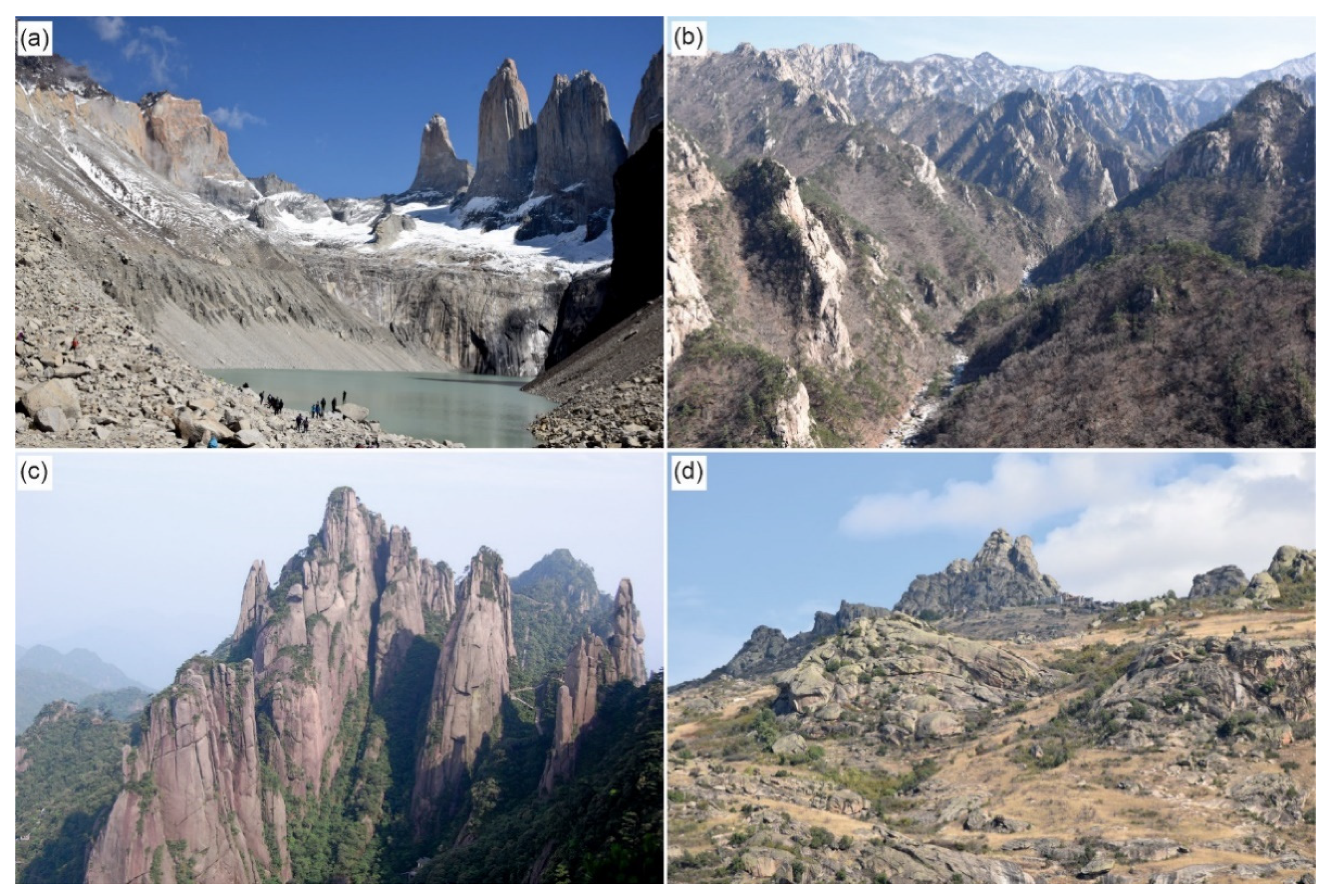
2.2.9. Stepped Relief

The name applies to terrain elevations where altitude gain is stepwise rather than gradual. First recognized in Sierra Nevada, USA [63], topography consists of alternating scarps (risers) and surfaces of low relief (treads) in between. The distribution of bedrock outcrops shows much sympathy to this gross relief pattern in that steps abound in boulder clusters, rock slopes and half-exposed domes, whereas treads are underlain by thick grus-weathering mantles. Wahrhaftig [63] disproved fault, lithological contact or master joint control on the location of risers and proposed that differential weathering plays the key role. For reasons not fully understood, the concept of long-term differential weathering to produce stepped mountainous topography was not systematically applied to other localities and remains to be tested for wider applicability.

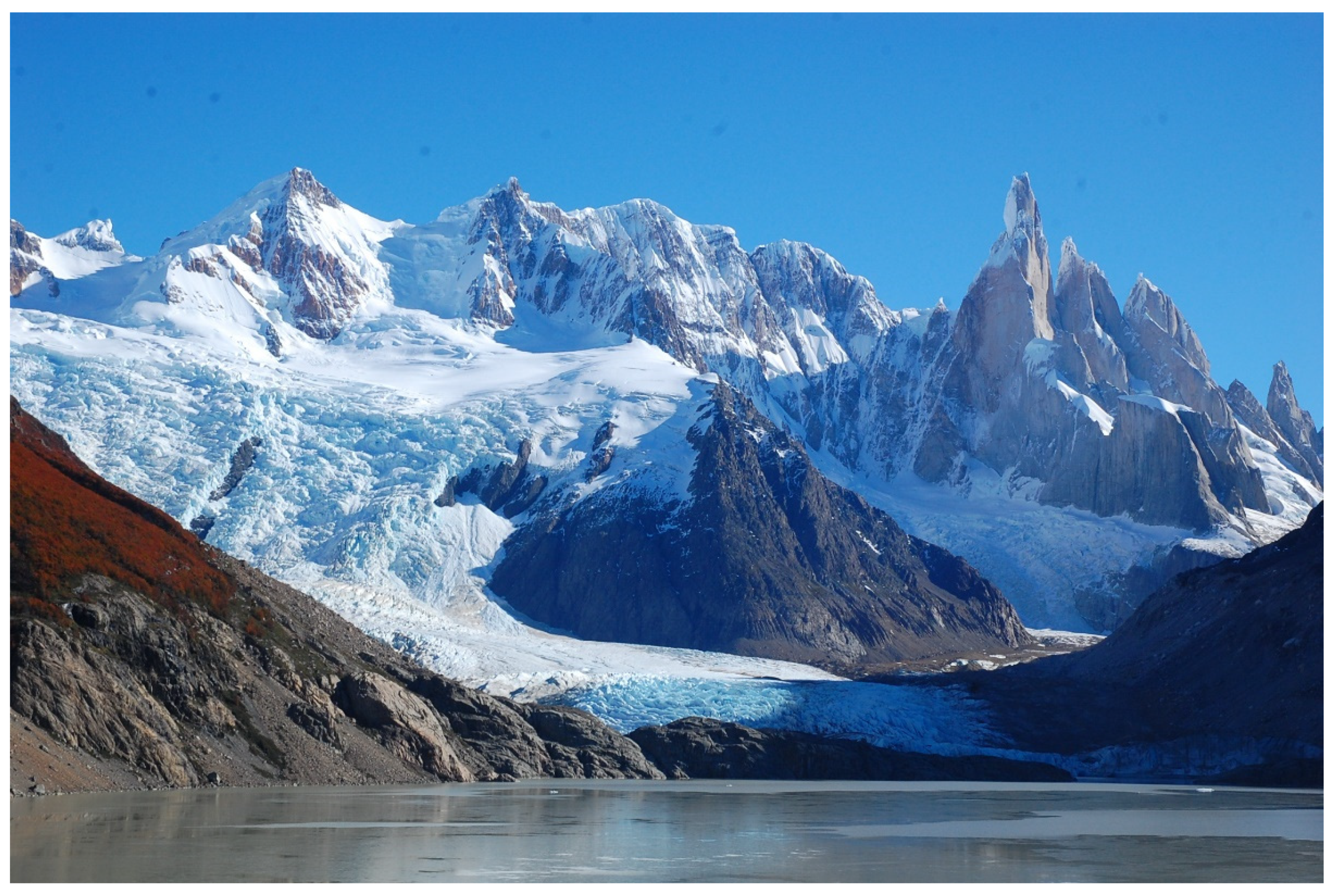
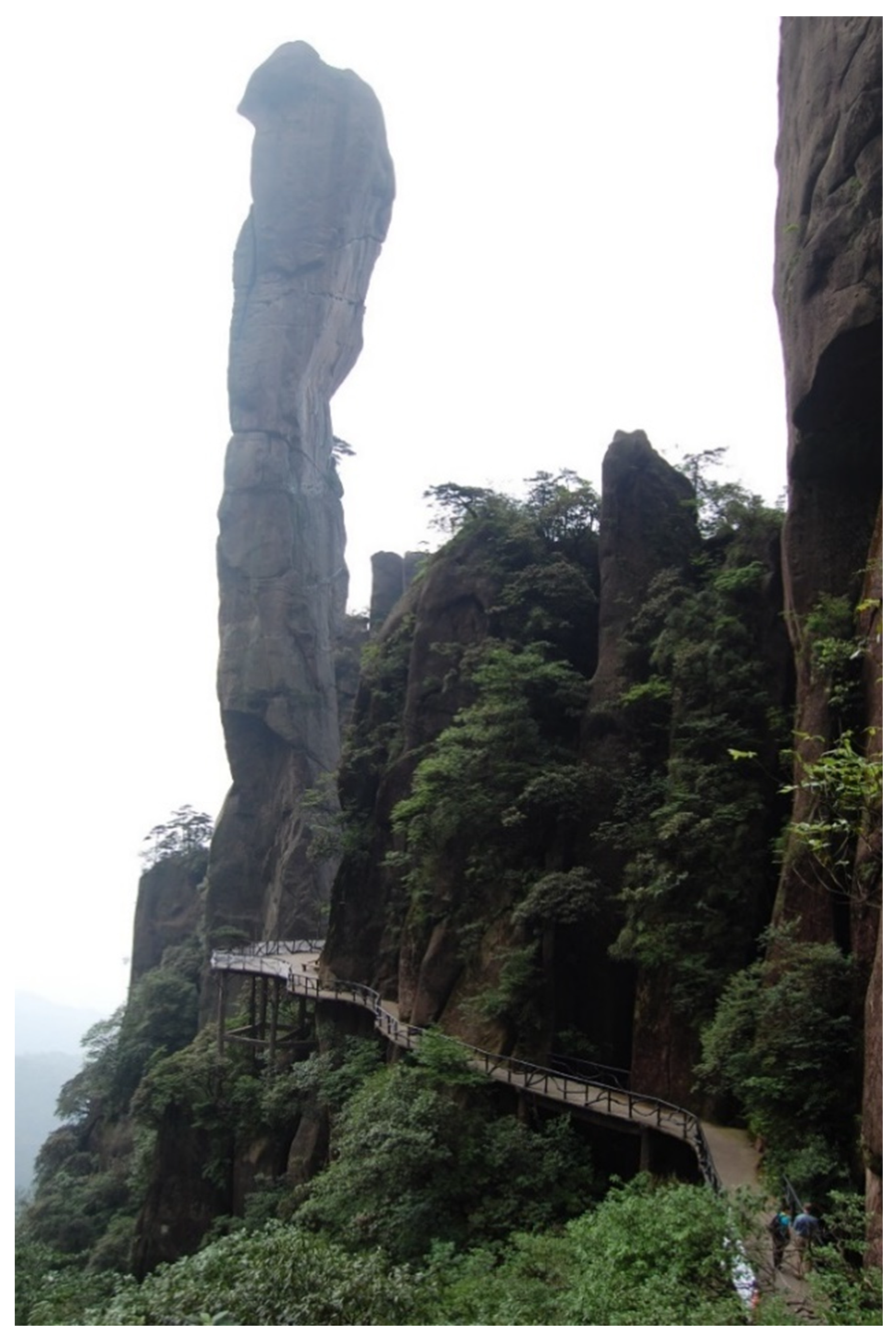
2.2.10. All-Slopes Relief

All-slopes relief was the term suggested by Twidale [30] and is essentially synonymous with mountainous topography, where surfaces of low relief, whether on interfluves or along the rivers, are absent. Fluvial dissection and glacial deepening of valleys, followed by mass movements on oversteepened slopes are the key players in topographic evolution. All-slopes topography occurs in many variants, depending on relative relief, intensity of fluvial and glacial erosion, efficacy of weathering systems, and mechanical properties of granites themselves. In high mountains extremely steep, nearly vertical slopes may dominate, whereas the crests are serrated, moulded into towers and pinnacles, separated by deep clefts and ravines (Figure 3a). Glacial undercutting may result in the origin of vertical cliffs many hundreds of metres high. However, steep rock slopes may evolve without the contribution from glacial processes, in response to deep joint-guided fluvial incision of an otherwise massive and mechanically strong granite. A good example is provided by Seoraksan mountain range in Korea, where relative relief is in the order of 1000 m and nearly vertical rock slopes extend for 200–400 m (Figure 3b) [64]. A peculiar variant of all-slopes topography is represented by Sanqingshan mountain group in te eastern part of China, sculpted into an array of towers and pinnacles separated by steep ravines, which however lack streams and seem to be primarily deepened by weathering and mass movements (Figure 3c). Other variants of all-slopes relief are not dominated by bare rock slopes, but instead by slopes carrying a thin regolith veneer. Shallow mass movements periodically remove the regolith mantle and rejuvenate the hillslope weathering system [65]. Transitional variants may also occur, where variously inclined bare rock slopes and regolith-covered segments co-exist, forming a complex pattern of hillslope facets (Figure 3d).

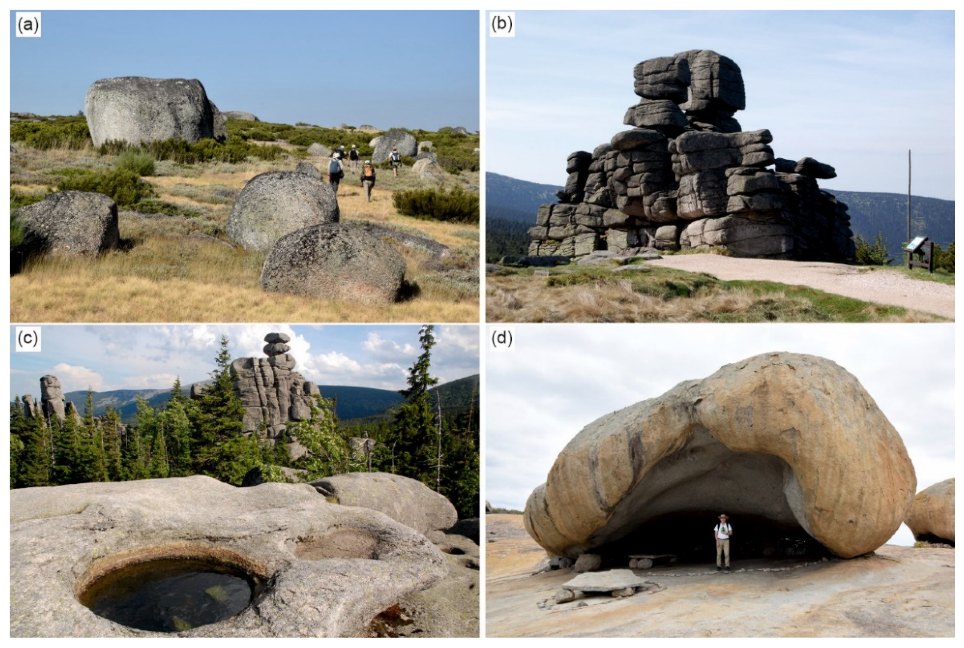
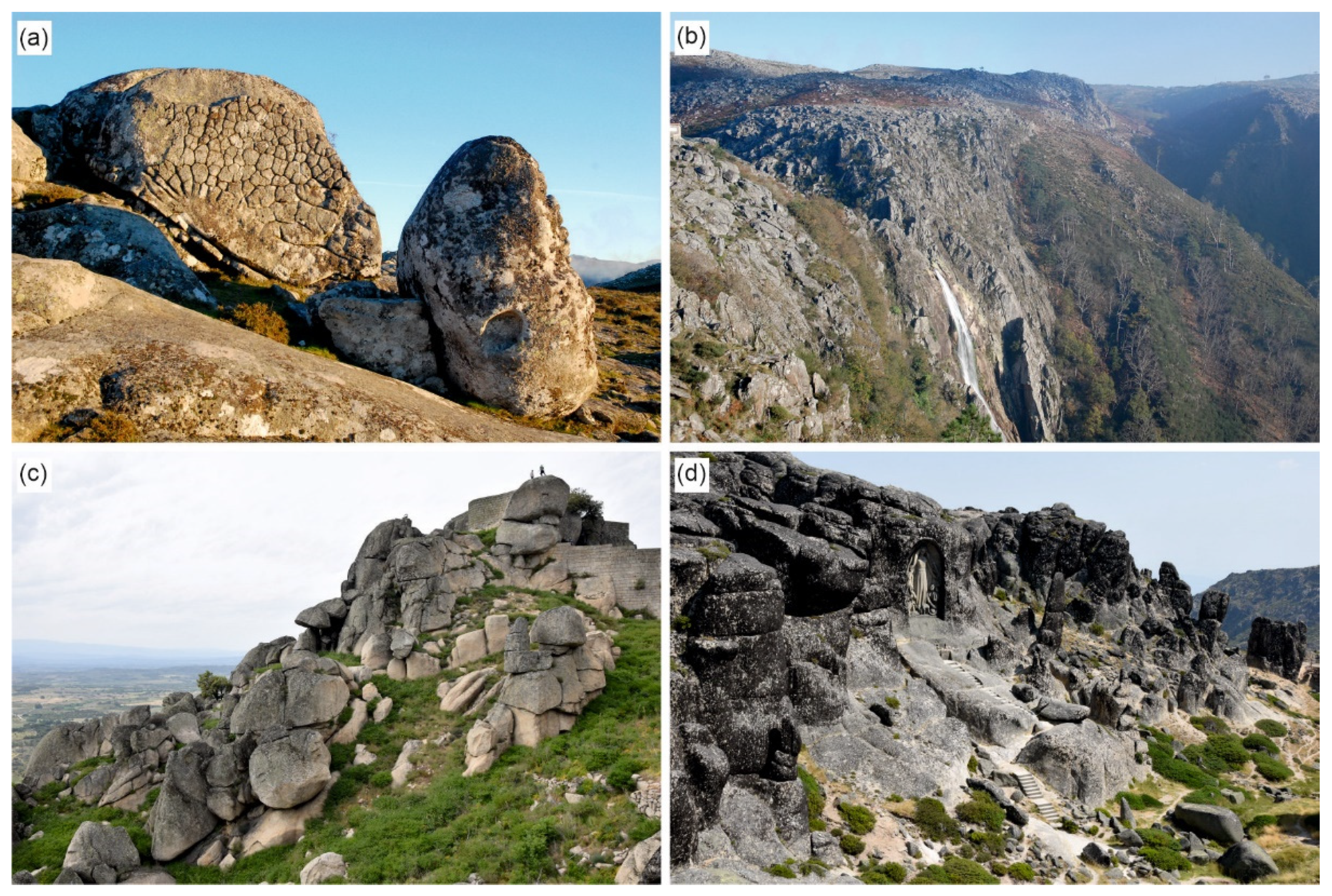
2.3. Characteristic Medium- and Small-Size Landforms

Superimposed on the principal types of terrain are various medium- and small-size landforms, which have long captured attention of scientists and lay people alike. Interestingly, scholarly literature focused on these medium and minor features appears much more voluminous than that aimed at deciphering gross landscape evolution.
Landforms of particular interest are weathering features, isolated rock outcrops—boulders and tors, and all those forming geomorphic evidence of periglacial (cold climate) environments. Boulders are common in many granite landscapes, occurring either in isolation or in smaller and larger clusters (Figure 4a). Many are strikingly rounded, which is thought to result primarily from subsurface weathering, focused on joints and especially, on joint intersections. Subsequent removal of incoherent saprolites exposes boulders as residual elements in various settings, on plateaus, slopes, in valley bottoms etc. [25,30]. Whereas it is true that boulders are not specific to granites and occur in many other lithologies as well, those built of granite often attain dimensions unparalleled in any other rock types. Lengths above 10 m are not uncommon and one of the largest boulders recorded is 33 × 21 × 12 m [30]. Evacuation of weathered portions of rock may leave interconnected voids, big enough to be considered as caves, yet to be systematically inventoried in the international context. In other places, removal of fines by subsurface flow has led to the origin of block streams, which may be hundreds of metres long [66].
Tors, defined by Linton [51], (p. 470) as “solid rock outcrops as big as a house rising abruptly from the smooth and gentle slopes of a rounded summit of broadly convex ridge” and vehemently discussed in the 1960s see [25] for a summary, are now understood as residual landforms rising from a regolith-veneered surface or a rock platform, composed of more than one joint-bound compartments but too small to be considered a separate hill (Figure 4b). They are ubiquitous medium-size granite landforms, although they do not occur in each granite terrain. They are common on plateaus, within multi-concave relief and across undulating hilly lands, but absent in all-slopes relief and rare within plains and multi-convex relief. Tors were proposed to be unweathered parts of the saprolite, which survived deep weathering and have become exposed through regolith evacuation [51], but they continue to evolve in subaerial conditions, gaining height or disintegrating into boulder piles [36,67]. As they may form and decay according to different scenarios, they are potentially valuable palaeoenvironmental indicators [68], although care should be exercised in interpretation. Of particular significance is the role of tors as indicators of the magnitude of glacial erosion [69]. Tors, along with big boulders, have generated considerable curiosity of ordinary people since times immemorial and in many areas are associated with fairy tales, folk legends, historical events, thus acquiring significance that goes far beyond the scientific one.
Among minor landforms inset into bare granite surfaces and produced by selective weathering, both in the subsurface and after exposure, the most characteristic ones are weathering pits (gnammas) (Figure 4c), tafoni—large hollows into vertical rock cliffs or boulders (Figure 4d), unusual polygonal patterns of shallow cracks, and flutes resembling karren known from limestone outcrops. As with boulders, all these features can also be found in other lithologies, but in granite they may attain gigantic dimensions. For example, tafoni in massive granite residuals in the Brazilian North-east are tens of metres deep and high, much exceeding those known from the “type” Mediterranean area [70]. Comprehensive discussion of these various microforms is beyond the scope and limits of this paper, but can be found in reviews such as [25,30,71].
Periglacial landforms common in mid-latitude granite terrains, largely inherited from the Pleistocene, and high-latitude areas, still evolving, include block fields and block streams composed of angular rock fragments, mid-slope bedrock cliffs, solifluction sheets and lobes [25,72]. Among them, block fields are widespread and may include features suggestive of downslope creep in the presence of ground ice [64], acquiring therefore a special significance for reconstructing palaeoenvironments.

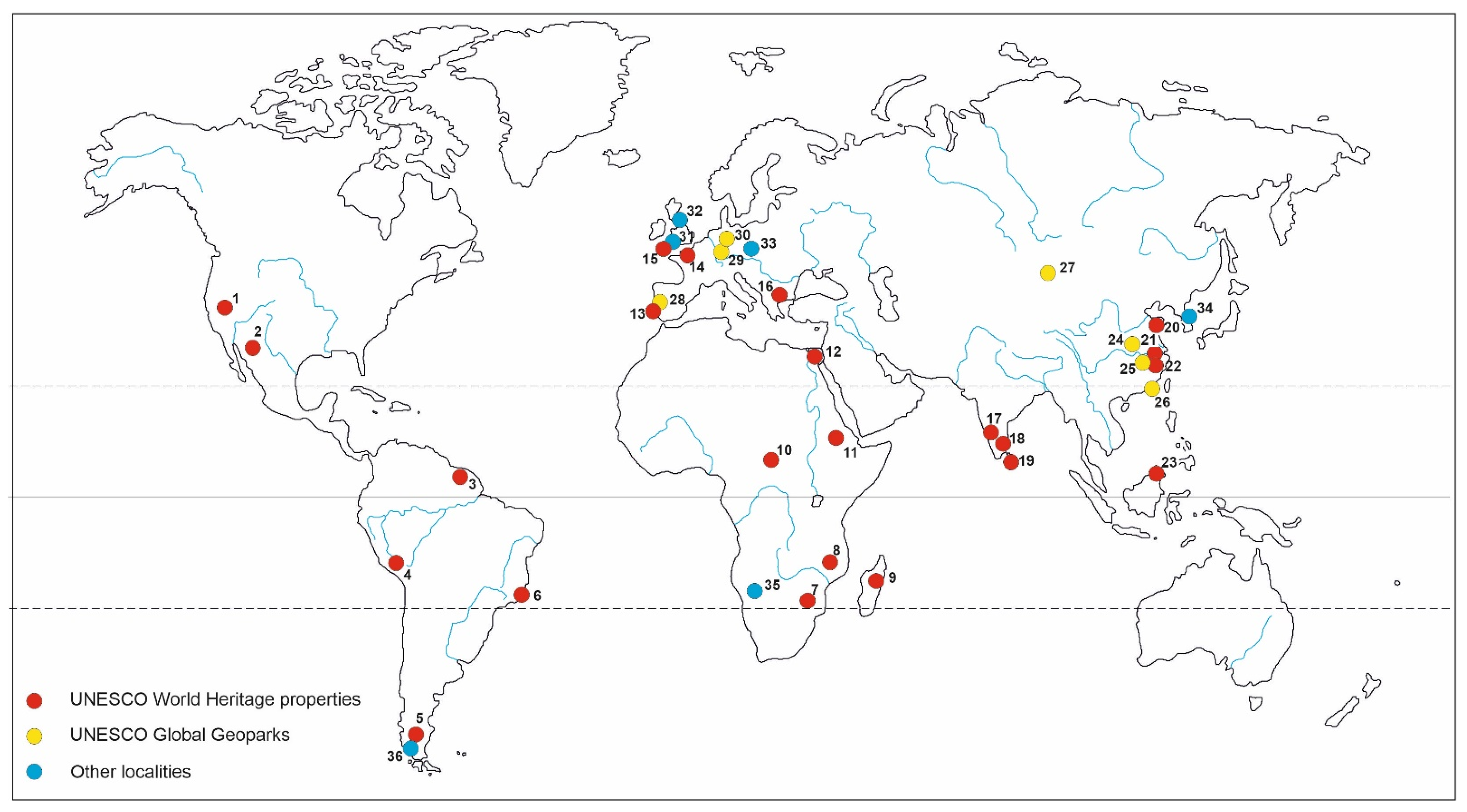
3. Granite Landforms and UNESCO World Heritage

3.1. Criteria

Properties can be inscribed on the UNESCO World Heritage List using at least one of ten criteria specified in the World Heritage Convention [15]. These criteria are divided into those applicable to cultural properties (i to vi) and those covering natural properties (vii to x). Among the latter, criterion (viii) explicitly addresses geoheritage and geodiversity, stating that the properties should “be outstanding examples representing major stages of earth’s history, including the record of life, significant on-going geological processes in the development of landforms, or significant geomorphic or physiographic features”, and therefore is most relevant. Granite landscapes may be thus considered as significant geomorphic features and show significant processes involved in shaping the scenery. However, an operational problem here is that no agreed understanding of “significance” in the context of landforms and geomorphological landscapes is available. This issue was discussed at length by Migoń [73] who argued that landforms at a given locality may be significant for: (a) The science of geomorphology itself; (b) for biotic world, crucially underpinning its existence and diversity; and (c) cultural heritage, again underpinning its development and survival. Cases of (b) and (c) are illustrated by a number of World Heritage properties inscribed under criteria different than (viii), which include granite sceneries, but not recognized themselves as of outstanding universal value (see below, Table 1). But even within criterion (viii) interpretations of “significance” may vary. It may reside in the ability of specific landforms to tell a story about long-term evolution of the Earth surface, their “classic” appearance, so that they are presented as best examples of a particular category of process–form relationships, their role played in the history of science, or imposing dimensions, including “world records”. The latter may be downplayed as not really scientific, but in fact, such localities inform about the power of certain surface processes and help to establish magnitude–frequency relationships. On the other hand, practice tells us that “significance” should not be linked with a too specialist aspect, hardly comprehended by people from outside the geoscientific community.
Criterion (vii) addresses scenic beauty of natural landscapes, using the following wording: “[Properties have] to contain superlative natural phenomena or areas of exceptional natural beauty and aesthetic importance”. However, scenic qualities of a landscape arise, among others and often in a decisive way, from its topographic configuration. Therefore, this criterion is also directly applicable, even if it is considerably more subjective but see [74]. Criteria (ix) and (x) emphasize ecological processes and biodiversity, respectively. Criteria set for cultural properties highlight different aspects of cultural heritage, including the criterion (v) that deems that properties “to be an outstanding example of a traditional human settlement, land-use, or sea-use which is representative of a culture (or cultures), or human interaction with the environment especially when it has become vulnerable under the impact of irreversible change”. Its particular relevance relates to the fact that specific patterns of granite landforms were underpinning specific land uses, conspiring to create cultural landscapes, with erected structures perfectly blended with the natural scenery.
In the following part of the paper the current representation of distinctive granite landscapes on the UNESCO World Heritage List is reviewed (Table 1 and Table 2; Figure 5), but an important comment is that the list below must not be interpreted as the evidence of recognition of outstanding universal value (OUV) of geomorphology present within a property. This particularly applies to properties inscribed under criteria (ix), (x), and all cultural criteria. It is the OUV statement that makes clear why the World Heritage status was awarded. Nonetheless, the very inscription offers potential for better recognition and, on the other hand, ensures more efficient conservation of physical landscape.

3.2. Current Representation

3.2.1. Granite Terrains Inscribed under Criterion (viii)

As for 2020, only four natural properties containing widespread granite landforms are inscribed under this criterion, most relevant from the geoscientific point of view. Two of them represent all-slopes topography in a variant shaped primarily by glaciers, which are either still present (Los Glaciares) and have disappeared but left clear geomorphic record (Pirin). However, they differ in detail, with massive granites in the former area supporting tower-like peaks of Cerro Torre and Fitzroy, with their hundred metres high vertical cliffs (Figure 6). The granite landscape of Yosemite also bears distinctive evidence of glacial remodelling, including spectacular glacial troughs up to 800 m deep and hanging valleys with waterfalls [75]. The justification of inscription under criterion (viii) clearly highlights geomorphological significance by saying “Glacial action combined with the granitic bedrock has produced unique and pronounced landform features including distinctive polished dome structures, as well as hanging valleys, tarns, moraines and U-shaped valleys. Granitic landforms such as Half Dome and the vertical walls of El Capitan are classic distinctive reflections of geologic history. No other area portrays the effects of glaciation on underlying granitic domes as well as Yosemite does” [76]. The fourth property, El Pinacate and Gran Desierto de Altar Biosphere Reserve represents an arid landscape, where dunes and volcanic landforms are of primary importance, but it also includes “several arid granite massifs, some as high as 650 m” [77].

3.2.2. Granite Terrains Inscribed under Criterion (vii)

Only four properties are inscribed under criterion (vii), including tree located in East China and one in Peru. Two of these (Taishan, Sanqingshan) represent all-slopes topography, developed due to advanced erosional dissection of the respective granite massifs, whereas Huangshan contains a central plateau dissected by several valleys radiating in different directions, fringed by all-slopes topography that provides connection between the high mountain massif (1964 m a.s.l.) and the surrounding, less elevated terrain. Geomorphologically, these three areas show some similarities, but the specific patterns of granite landforms are different [78,79]. Huangshan includes numerous massive granite domes encircling the central plateau [80], whereas Sanqingshan granite is more jointed along vertical discontinuities, which produces an erosional topography dominated by conical peaks, spires and pinnacles, including many unusual shapes such as Big Boa, claimed to be 128 m high (Figure 7). The areas also differ in terms of the age of granite. Whereas granites of Huangshan and Sanqingshan are of Cretaceous age, those of Taishan are Precambrian. In addition to natural values, each property is of outstanding cultural significance for Chinese history, with Taishan being one of sacred mountains for Tao religion and inscribed under all criteria relevant to cultural properties. The Peruvian site of Machu Picchu is most famous for its archaeology and architectural legacy of Inca empire, but the ruins sit in the splendid geomorphological context of extremely rugged and steep mountains, with numerous dome-like and conical peaks [81].

3.2.3. Granite Terrains Inscribed under Criteria (ix) and (x)

Three inscriptions under solely biological criteria mention granite landforms, although in neither case was their diversity or possible international significance explored in detail. Mount Kinabalu is researched best, especially in regard to the age of granite (c. 7.8–7.2 Ma according to recent estimates [82]) and post-emplacement uplift and unroofing history [83]. The region is also significant for its legacy of Pleistocene glaciation, unique for the equatorial belt in SE Asia, although details of glacier morphogenesis remain controversial [84]. Two other areas contain residual hills (inselbergs), which seem to be more striking in the humid tropical Central Suriname Nature Reserve as suggested by the phrase “geologically remarkable individual granite inselbergs” included in the characterization of the property [85] and web-based photography. The respective description for the Manovo-Gounda St Floris National Park only mentions “small granitary inselbergs” (sic) [86].

3.2.4. Granite Terrains within Cultural Properties

There are at least twelve cultural properties distinctively associated with granite scenery. These sceneries represent a variety of geomorphological settings (Table 1), occasionally complex themselves. Descriptions available at [87] and relevant geomorphological literature suggest that granite landscapes at these sites vary from very striking and potentially very significant from geoscientific point of view to rather ordinary. The most impressive are numerous domes and forested ridges in Rio de Janeiro [88], forming the stage for the cultural heritage of the city. This is acknowledged in the following statement backing OUV of the property: “Its exceptionally dramatic landscape is punctuated by a series of forested mountains that tower over the city, rising to the uppermost peak of the Tijuca massif at 1021 m high, and cascading down to the coast where the steep cone shapes of Sugar Loaf (Pão de Açúcar), Urca, Cara de Cão, and Corcovado frame the wide sweeps of Guanabara Bay that shelters Rio de Janeiro from the Atlantic Ocean” [89]. Another striking landform is the flat-topped inselberg of Sigiriya in Sri Lanka that hosts an important ancient fortress [90]. Technically, the rock is granite-gneiss, derived from metamorphosis of primary granite [91], but the relevant description on the World Heritage Committee website identifies it as granite. High geomorphic significance appears also associated with the Matobo Hills in Zimbabwe, as suggested by the web-based description: “The Matobo Hills […] are a profusion of distinctive granite landforms, densely packed into a comparatively tight area, that rise up to form a sea of hills. Their forms have resulted from the varied composition and alignment of the granite rocks, which responded differently to millions of years of weathering. These extraordinary granite rock formations have exerted a strong presence over the whole area—both in natural and cultural terms” [92]. Limited literature, some of it popular science rather than strictly academic [40,93,94], suggests that the area represents an excellent example of complex denudational landscape, with multi-convex and joint-valley compartments, as well as the variety of minor forms: Boulders, tors and rock shelters.
The remaining cultural properties seem not to contain geoheritage of international significance, although the enhancing role of natural scenery for localities such as Saint Catherine Area, Mont Saint-Michel, Group of Monuments at Hampi, Chongoni Rock-Art Area or Cultural Landscape of Sintra cannot be neglected. Overviews of granite geomorphology at selected localities can be found in [95,96,97,98].

4. Granite Landforms and UNESCO Global Geoparks

Proper evaluation of the representation of granite landforms and landscapes within UNESCO Global Geoparks is hindered by the paucity of widely available information, especially in respect to non-European countries. Similar limitations were also noted by Ruban [99] in the context of analysis focused on representation of geological periods within Geoparks. Moreover, Geoparks typically cover large territories of complex geology and geomorphology, so that granite rocks may be present but are not specifically highlighted if other aspects of regional geoheritage are considered of higher value. With this caveat in mind, it is probably correct to say that only some 10–15 UNESCO Global Geoparks, among more than 150 in total, contain granite sceneries of considerable value. Using the UGG website as the source of information [100], the presence of granite topography is highlighted in several Chinese Global Geoparks (Funiushan, Jiuhuashan, Keketuohai, Ningde, and Tianzhushan), in addition to Huangshan, Sanqingshan and Taishan, which are also UNESCO World Heritage properties (see Section 3.2.2). Among them, Keketuohai in the Altai Mountains represents high-mountain topography and is likened to Yosemite in the web-available description, whereas the remaining ones fall into category of all-slopes relief formed without contribution from glacial valley deepening.
Granite sceneries dominate in three Portuguese Geoparks: Arouca, Serra da Estrela and Naturtejo. The former two show high-elevation dissected plateaus, dotted with tors and nubbin hills, with plentiful boulders and interesting weathering microforms [101,102], whereas Naturtejo is best classified as a plain with inselbergs, although some of these residual massifs are large enough to be considered separately as examples of all-slopes topography [60]. Tors, including curious pedestal rocks, and boulder fields are also common. In addition, Serra da Estrela offers magnificent evidence of glacial erosion in the form of cirques, U-shaped valleys and roche mountonnées.
The granite theme is also present within two Geoparks in Germany—Bergstrasse–Odenwald and Harz, Braunschweiger Land, although both cover much larger areas than granite plutons. Specific granite landforms include numerous tors, block fields and block streams, genetically linked with periglacial conditions of the Pleistocene [27].
In UNESCO Global Geoparks (and national geoparks, if they exist, as well) interpretation of geoheritage for general public is invariably in focus and it has long been recognized that this is most efficiently achieved at specific localities—geosites [7,14,16]. In the context of geomorphological scenery, a specific category of geosites may be distinguished—geomorphosites, which show specific landforms and/or evidence of ongoing processes, well visible and relatively easy to comprehend, especially if aided by well-executed interpretation facilities [103,104,105,106]. Many individual granite landforms are excellent geomorphosites, not only because they are important scientifically, but they are also characteristic landmarks, able to attract attention of casual visitors as well. Inselbergs (or viewpoints offering their panoramic perspective), tors, boulder stream and weathering phenomena are developed as geo(morpho)sites and Figure 8 shows a selection of granite-related geosites of geomorphological nature from the UNESCO Global Geoparks in Portugal. In addition, granite being hard rock, these geomorphosites are relatively resilient, even if visited by a large number of tourists. Inherent problems of geoconservation such as accelerated erosion, defacing of rock outcrops (painting, chiselling), natural disintegration due to ongoing weathering, all widely encountered on soft and moderately strong rocks [6], are less relevant in granite areas.

5. Global Recognition—Challenges and Opportunities

The above review of geodiversity of granite terrains on the one hand, and its international recognition on the other one, lead to the following summary observations. First, despite globally widespread occurrence of granite landscapes and their undoubted scenic qualities and scientific significance, their representation within the UNESCO World Heritage List is remarkably limited, and the same applies to the UNESCO Global Geoparks network. Second, only four granite terrains were inscribed in explicit recognition of their geoheritage values (criterion viii), whereas an outstanding universal value statement highlights granite landforms in one case only (Yosemite). Third, four more properties have been recognized for their scenery, but not explicitly for geoheritage. In at least one of these cases, inscription under criterion (viii) was applied for, but was rejected. This was partly related to insufficient science-based justification at the global scale. Fourth, there are more than ten UNESCO World Heritage properties at which granite landforms underpin cultural heritage of universal value. In some of these properties, these natural landform assemblages are iconic geomorphological sceneries and may qualify for recognition under natural criteria. Fifth, it seems that a general framework to evaluate significance and potential outstanding universal value of granite terrains is missing and comparative analysis would need to be performed at ad hoc basis. The refined guidelines for criterion (viii) will partially help, but granite landscapes are often very distinctive types of “erosional systems”, difficult to compare with erosional landscapes developed on other rock types.
Challenges facing the recognition of significance of granite geomorphology at an international level are basically twofold, related to the very definition of global “significance” and to the framework that can be adopted to facilitate comparative analysis and eventually, such recognition. Having principal types of granite landscapes identified, work towards adequate representation of these types may be envisaged, although some sceneries such as plains are unlikely candidates for any kind of distinction under existing global initiatives, despite their considerable scientific significance. One needs also to observe that some landscape types are already represented within World Heritage properties, although they are not necessarily the best examples. Actually, geoscientific understanding of many existing World Heritage properties is far from complete and more effort to fill these gaps is recommended. Global significance may also be ascribed to particularly rich inventories of granite landforms at medium- and minor scale, an aspect apparently not addressed until now, as well as to areas, which yielded benchmark studies in geomorphology, not necessarily limited to problems of granite landforms. Dartmoor in SW England is one such example [53] and the Cairngorms in Scotland is another one [54,55]. Iconic vistas such as Spitzkoppe in Namibia or Torres del Paine in Chile (Figure 1 and Figure 3a) are also worth exploring for their possible outstanding universal value. Striking examples of granite mountainous sceneries exist in the Korean Peninsula, recently explored in terms of their geodiversity and geoheritage value, possibly of global significance [64,107]. Another promising avenue of inquiry might be focused on very large granite domes in near-equatorial cratonic areas, such as Nigeria [33,36] and North-East Brazil [70,108]. Their assemblages are both highly scenic and archetypal, and if modern dating techniques to measure bedrock erosion rates are applied, they may yield important information about landscape evolution over very long timescales. Finally, an approach to granite landscapes followed in this paper was essentially geomorphological, whereas granite massifs may also provide unique insights into deep Earth and serve as key markers of geotectonic evolution. Exploration of linkages between geology of granite and “major stages of earth’s history”, as included into criterion (viii), may provide additional context for global recognition of specific areas.
The accumulated knowledge about the origin and characteristics of granite sceneries allows one to propose the following evaluation framework suited to the global context (Table 3).
Limited representation of granite landscapes on both the UNESCO World Heritage List and within the UNESCO Global Geopark network creates room for future nominations/applications, as well as re-nominations of some existing properties under criterion (viii). The existing coverage is evidently uneven and some types of granite sceneries, which arguably count as “significant geomorphic or physiographic features” are either completely missing or may have more adequate representation, which would also observe integrity requirements for individual properties. These include inselbergs and multi-convex relief, joint-valley landscapes, plateaus, complex mountain erosional systems developed without the role of glaciation, and erosional coastal sceneries. The widespread worldwide occurrence of granites provides an excellent basis for global comparative analysis and will inform recognition of common versus outstanding and unique geomorphic features. However, it is necessary recalling Badman’s observation ([19], p. 359) that “the necessarily selective nature of World Heritage listing cannot be regarded as adequate for recognizing the full range of globally significant geological sites” and any expectations that the entire diversity of granite geomorphological sceneries may be accommodated within UNESCO World Heritage properties are simply unrealistic.

6. Conclusions

This paper aimed at evaluation of granite geomorphological sceneries in the global geoheritage context. Based on existing literature, ten distinctive types of relief were identified, along with several sub-types, and an overview of medium-size and minor landforms characteristic for granite terrains was provided. It was argued that not only are they immensely scenic, but their main values reside in the ability to tell stories about landscape evolution and environmental changes over geological timescale. This potential and significance are only partly realized in the global context, as demonstrated by relatively scarce representation of granite landscapes and landforms on the UNESCO World Heritage List and within the UNESCO Global Geopark network. Moreover, analysis of documents reveals that only a few granite properties have been awarded World Heritage status in recognition of their scientific value or unique scenery. Much more often, reasons for inscription reside elsewhere, in biodiversity or cultural heritage values. In some of these cases, the significance of geoheritage was evidently underrated and/or nor sufficiently realized. To facilitate future global comparative analysis a framework was proposed that can be used for this purpose. Voluminous literature on geodiversity and geoheritage of granite areas in site-specific context is available to inform any attempts to evaluate granite terrains from this perspective at the global scale.

Funding

This research received no external funding.

Data Availability Statement

Data sharing is not applicable to this article.

Acknowledgments

Writing this paper would not be possible without the help of many friends and colleagues whose courtesy allowed me to see various granite landscapes over the world and to build my experience. I am equally grateful to people with whom I had a pleasure to discuss problems of the origin of granite landforms and evaluation of their significance. These are particularly, in alphabetical order, Andrew Goudie, Karna Lidmar-Bergström, Rubson Pinheiro Maia, Ivica Milevski, Mats Olvmo, Michael Thomas, Gonçalo Vieira, Kyung Sik Woo, and the late Chris Wood. Useful comments from journal reviewers helped to enhance the paper and are gratefully acknowledged.

Conflicts of Interest

The author declares no conflict of interest.

References

  1. Brocx, M.; Semeniuk, V. Geoheritage and geoconservation—History, definition, scope and scale. J. R. Soc. West. Aust. 2007, 90, 53–87. [Google Scholar]
  2. Gordon, J. Geoheritage, geotourism and the cultural landscape: Enhancing the visitor experience and promoting geoconservation. Geosciences 2018, 8, 136. [Google Scholar] [CrossRef] [Green Version]
  3. Gray, M. Geodiversity: Valuing and Conserving Abiotic Nature, 2nd ed.; Wiley Blackwell: Chichester, UK, 2013. [Google Scholar]
  4. Zwoliński, Z.; Najwer, A.; Giardino, M. Methods for assessing geodiversity. In Geoheritage, Assessment, Protection and Management; Reynard, E., Brilha, J., Eds.; Elsevier: Amsterdam, The Netherlands, 2018; pp. 27–52. [Google Scholar]
  5. Ollier, C.D. Problems of geotourism and geodiversity. Quaest. Geogr. 2012, 31, 57–61. [Google Scholar] [CrossRef] [Green Version]
  6. Prosser, C.D.; Díaz-Martínez, E.; Larwood, J.G. The Conservation of Geosites: Principles and Practice. In Geoheritage, Assessment, Protection and Management; Reynard, E., Brilha, J., Eds.; Elsevier: Amsterdam, The Netherlands, 2018; pp. 193–212. [Google Scholar]
  7. UNESCO Global Geoparks. Available online: www.unesco.org/new/en/natural-sciences/environment/earth-sciences/unesco-global-geoparks/fundamental-features (accessed on 31 December 2020).
  8. Reynard, E.; Fontana, G.; Kozlik, L.; Scapozza, C. A method for assessing scientific and additional values of geomorphosites. Geogr. Helv. 2007, 62, 148–158. [Google Scholar] [CrossRef]
  9. Reynard, E.; Perret, A.; Bussard, J.; Grangier, L.; Martin, S. Integrated approach for the inventory and management of geomorphological heritage at the regional scale. Geoheritage 2016, 8, 43–60. [Google Scholar] [CrossRef]
  10. Pereira, P.; Pereira, D.; Caetano Alves, M.I. Geomorphosite assessment in Montesinho Natural Park (Portugal). Geogr. Helv. 2007, 62, 159–168. [Google Scholar] [CrossRef] [Green Version]
  11. Vujičić, M.D.; Vasiljević, D.A.; Marković, S.B.; Hose, T.A.; Lukić, T.; Hadžić, O.; Janićević, S. Preliminary geosite assessment model (GAM) and its application on Fruška Gora mountain, potential geotourism destination of Serbia. Acta Geogr. Slov. 2011, 51, 361–377. [Google Scholar] [CrossRef]
  12. Kubaliková, L. Geomorphosite assessment for geotourism purposes. Czech J. Tour. 2013, 2, 80–104. [Google Scholar] [CrossRef]
  13. Różycka, M.; Migoń, P. Customer-oriented evaluation of geoheritage—On the example of volcanic geosites in the West Sudetes, SW Poland. Geoheritage 2018, 10, 23–37. [Google Scholar] [CrossRef]
  14. Brilha, J. Inventory and quantitative assessment of geosites and geodiversity sites: A review. Geoheritage 2016, 8, 119–134. [Google Scholar] [CrossRef] [Green Version]
  15. Migoń, P. Geoheritage and World Heritage. In Geoheritage. Assessment, Protection and Management; Reynard, E., Brilha, J., Eds.; Elsevier: Amsterdam, The Netherlands, 2018; pp. 237–249. [Google Scholar]
  16. Brilha, J. Geoheritage and Geoparks. In Geoheritage, Assessment, Protection and Management; Reynard, E., Brilha, J., Eds.; Elsevier: Amsterdam, The Netherlands, 2018; pp. 323–335. [Google Scholar]
  17. World Heritage Convention. Available online: https://whc.unesco.org/en/convention (accessed on 31 December 2020).
  18. Dingwall, P.; Weighell, T.; Badman, T. Geological World Heritage: A Global Framework; IUCN: Gland, Switzerland, 2005. [Google Scholar]
  19. Badman, T. World Heritage and geomorphology. In Geomorphological Landscapes of the World; Migoń, P., Ed.; Springer: Dordrecht, The Netherlands, 2010; pp. 357–368. [Google Scholar]
  20. McKeever, P.; Narbonne, G. Personal communication, 2020.
  21. Wood, C. World Heritage Volcanoes: Thematic Study; IUCN: Gland, Switzerland, 2009. [Google Scholar]
  22. Casadevall, T.; Tormey, D.; Roberts, J. World Heritage Volcanoes: Classification, Gap Analysis, and Recommendations for Future Listings; IUCN: Gland, Switzerland, 2019. [Google Scholar]
  23. Williams, P.W. World Heritage Caves and Karst. A Thematic Study; IUCN: Gland, Switzerland, 2008. [Google Scholar]
  24. Goudie, A.; Seely, M. World Heritage Desert Landscapes. Potential Priorities for the Recognition of Desert Landscapes and Geomorphological Sites on the World Heritage List; IUCN: Gland, Switzerland, 2011. [Google Scholar]
  25. Migoń, P. Granite Landscapes of the World; Oxford University Press: Oxford, UK, 2006. [Google Scholar]
  26. Operational Guidelines for the Implementation of the World Heritage Convention; UNESCO: Paris, France, 2019; Available online: Whc.unesco.org/en/guidelines (accessed on 31 December 2020).
  27. Wilhelmy, H. Klimamorphologie der Massengesteine; Westermann: Braunschweig, Germany, 1958. [Google Scholar]
  28. Thomas, M.F. Granite landforms: A review of some recurrent problems of interpretation. Inst. Br. Geogr. Spec. Publ. 1974, 7, 13–37. [Google Scholar]
  29. Godard, A. Pays et Paysages du Granite; Presses Universitaires de France: Paris, France, 1977. [Google Scholar]
  30. Twidale, C.R. Granite Landforms; Elsevier: Amsterdam, The Netherlands, 1982. [Google Scholar]
  31. Lidmar-Bergström, K. Relief and saprolites through time on the Baltic Shield. Geomorphology 1995, 12, 45–61. [Google Scholar] [CrossRef]
  32. Büdel, J. Die “Doppelten Einebnungsflächen” in den feuchten Tropen. Z. F. Geomorph. N. F. 1957, 1, 201–228. [Google Scholar]
  33. Thomas, M.F. The study of inselbergs. Z. F. Geomorph. N. F. Suppl. Bd. 1978, 31, 1–41. [Google Scholar]
  34. Twidale, C.R. Granite inselbergs: Domed, block-strewn and castellated. Geogr. J. 1981, 147, 54–71. [Google Scholar] [CrossRef]
  35. Ollier, C.D. Some features of granite weathering. Z. F. Geomorph. N. F. 1965, 9, 265–284. [Google Scholar]
  36. Thomas, M.F. Some aspects of the geomorphology of domes and tors in Nigeria. Z. F. Geomorph. N. F. 1965, 9, 63–81. [Google Scholar]
  37. King, L.C. The origin of bornhardts. Z. F. Geomorph. N. F. 1966, 10, 97–98. [Google Scholar]
  38. Twidale, C.R.; Bourne, J.A. Episodic exposure of inselbergs. Geol. Soc. Am. Bull. 1975, 86, 1473–1481. [Google Scholar] [CrossRef]
  39. Selby, M.J. Form and origin of some bornhardts of the Namib Desert. Z. F. Geomorph. N. F. 1982, 26, 1–15. [Google Scholar]
  40. Pye, K.; Goudie, A.S.; Thomas, D.S.G. A test of petrological control in the development of bornhardts and koppies on the Matopos Batholith, Zimbabwe. Earth Surf. Proc. Landf. 1984, 9, 455–467. [Google Scholar] [CrossRef]
  41. Pye, K.; Goudie, A.S.; Watson, A. Petrological influence on differential weathering and inselberg development in the Kora area of Central Kenya. Earth Surf. Proc. Landf. 1986, 11, 41–52. [Google Scholar] [CrossRef]
  42. Römer, W. The distribution of inselbergs and their relationship to geomorphological, structural and lithological controls in Southern Zimbabwe. Geomorphology 2005, 72, 156–176. [Google Scholar] [CrossRef]
  43. Matmon, A.; Mushkin, A.; Enzel, Y.; Grodek, T.; ASTER Team. Erosion of a granite inselberg, Gross Spitzkoppe, Namib Desert. Geomorphology 2013, 201, 52–59. [Google Scholar] [CrossRef]
  44. Migoń, P. Are any granite landscapes distinctive of the humid tropics? Reconsidering multiconvex topographies. Singap. J. Trop. Geogr. 2009, 30, 328–343. [Google Scholar] [CrossRef]
  45. Mäckel, R. Dambos and related landforms in Africa—an example for the ecological approach to tropical geomorphology. Z. F. Geomorph. N. F. Suppl. Bd. 1985, 52, 1–23. [Google Scholar]
  46. Thomas, M.F.; Thorp, M.B. Environmental change and episodic etchplanation in the humid tropics of Sierra Leone. In Environmental Change and Tropical Geomorphology; Douglas, I., Spencer, T., Eds.; Allen and Unwin: London, UK, 1985; pp. 239–267. [Google Scholar]
  47. Thomas, M.F. Models for landform development on passive margins. Some implications for relief development in glaciated areas. Geomorphology 1995, 12, 3–15. [Google Scholar] [CrossRef]
  48. Johansson, M.; Migoń, P.; Olvmo, M. Joint-controlled basin development in Bohus granite, SW Sweden. Geomorphology 2001, 40, 145–161. [Google Scholar] [CrossRef]
  49. Bremer, H. Intramontane Ebenen, Prozesse der Flächenbildung. Z. F. Geomorph. N. F. Suppl. Bd. 1975, 23, 26–48. [Google Scholar]
  50. Migoń, P.; Prokop, P. Landforms and landscape evolution in the Mylliem granite area, Meghalaya plateau, Northeast India. Singap. J. Trop. Geogr. 2013, 34, 206–228. [Google Scholar] [CrossRef]
  51. Linton, D.L. The problem of tors. Geogr. J. 1955, 121, 470–487. [Google Scholar] [CrossRef]
  52. Evans, D.J.A. Bodmin Moor. In Landscapes and Landforms of England and Wales; Goudie, A., Migoń, P., Eds.; Springer: Cham, Switzerland, 2020; pp. 257–268. [Google Scholar] [CrossRef]
  53. Gunnell, Y. Landscape evolution of Dartmoor, SW England: A review of evidence-based controversies and their wider implications for geoscience. Proc. Geol. Assoc. 2020, 131, 187–226. [Google Scholar] [CrossRef]
  54. Sugden, D.E. The selectivity of glacial erosion in the Cairngorm mountains. Inst. Brit. Geogr. Trans. 1968, 45, 79–92. [Google Scholar] [CrossRef]
  55. Hall, A.M.; Gillespie, M.R.; Thomas, C.W.; Ebert, K. Scottish landform examples: The Cairngorms—A pre-glacial upland granite landscape. Scot. Geogr. J. 2013, 129, 2–14. [Google Scholar] [CrossRef] [Green Version]
  56. Migoń, P.; Vieira, G.T. Granite geomorphology and its geological controls, Serra da Estrela, Portugal. Geomorphology 2014, 226, 1–14. [Google Scholar] [CrossRef]
  57. Votýpka, J. Tvary zvětrávání a odnosu žuly v severní částí Novobystřické vrchoviny. Sborník Ceskoslov. Společnosti Zeměpisné 1964, 69, 243–258. [Google Scholar]
  58. Migoń, P.; Różycka, M.; Michniewicz, A. Conservation and geotourism perspectives at granite geoheritage sites of Lower Austria. Geoheritage 2018, 10, 11–21. [Google Scholar] [CrossRef]
  59. Mezősi, G. Granite Weathering in the Velence Hills. In Landscapes and Landforms of Hungary; Lóczy, D., Ed.; Springer: Dordrecht, The Netherlands, 2015; pp. 89–95. [Google Scholar]
  60. Neto de Carvalho, C.; Rodrigues, J. Naturtejo UNESCO Global Geopark: The culture of landscape. In Landscapes and Landforms of Portugal; Vieira, G., Zêzere, J.L., Mora, C., Eds.; Springer: Cham, Switzerland, 2020; pp. 359–375. [Google Scholar]
  61. Mabbutt, J.A. A study of granite relief from South West Africa. Geol. Mag. 1952, 89, 87–96. [Google Scholar] [CrossRef]
  62. Bremer, H. Reliefformen and reliefbildende Prozesse in Sri Lanka. Reliefboden Paläoklima 1981, 1, 7–183. [Google Scholar]
  63. Wahrhaftig, C. Stepped topography of the southern Sierra Nevada, California. Geol. Soc. Am. Bull. 1965, 76, 1165–1190. [Google Scholar] [CrossRef]
  64. Migoń, P.; Kasprzak, M.; Woo, K.-S. Granite landform diversity and dynamics underpin geoheritage values of Seoraksan Mountains, Republic of Korea. Geoheritage 2019, 11, 751–764. [Google Scholar] [CrossRef] [Green Version]
  65. Hirata, Y.; Chigira, M. Landslides associated with spheroidally weathered mantle of granite porphyry induced by 2011. Typhoon Talas in the Kii Peninsula, Japan. Eng. Geol. 2019, 260, 105217. [Google Scholar] [CrossRef]
  66. Bozhkov, P. Quantitative analysis of a stone run in Vitosha Mountain. In Proceedings of the International Scientific Conference Geobalcanica 2020, Ohrid, North Macedonia, 12–13 May 2020; pp. 137–143. [Google Scholar]
  67. Michniewicz, A.; Jancewicz, K.; Migoń, P. Large-Scale Geomorphological Mapping of Tors—Proposal of a Key and Landform Interpretation. Geomorphology 2020, 357, 107106. [Google Scholar] [CrossRef]
  68. Michniewicz, A. Tors in Central European Mountain—Are they indicators of past environments? Bull. Geogr. Phys. Geogr. Ser. 2019, 16, 67–87. [Google Scholar] [CrossRef] [Green Version]
  69. André, M.F. The geomorphic impact of glaciers as indicated by tors in North Sweden (Aurivaara, 68° N). Geomorphology 2004, 57, 403–421. [Google Scholar] [CrossRef]
  70. Migoń, P.; Maia, R.P. Pai Mateus, Pedra da Boca and Quixadá—Three possible Key Geoheritage Areas in north-east Brazil. Geoheritage 2020, 12, 51. [Google Scholar] [CrossRef]
  71. Twidale, C.R.; Vidal Romaní, J.R. Landforms and Geology of Granite Terrains; Balkema: Leiden, The Netherlands, 2005. [Google Scholar]
  72. Vieira, G.; Nieuwendam, A. Glacial and periglacial landscapes of the Serra da Estrela. In Landscapes and Landforms of Portugal; Vieira, G., Zêzere, J.L., Mora, C., Eds.; Springer: Cham, Switzerland, 2020; pp. 185–198. [Google Scholar]
  73. Migoń, P. The significance of landforms—The contribution of geomorphology to the World Heritage Programme of UNESCO. Earth Surf. Proc. Landf. 2014, 39, 836–843. [Google Scholar] [CrossRef]
  74. Mitchell, N.; Leitão, L.; Migon, P.; Denyer, S. Study on the Application of Criterion (vii): Considering Superlative Natural Phenomena and Exceptional Natural Beauty within the World Heritage Convention; IUCN: Gland, Switzerland, 2013. [Google Scholar]
  75. Huber, N.K. The geologic story of Yosemite National Park. USA Geol. Surv. Bull. 1987, 1595, 1–64. [Google Scholar]
  76. Yosemite National Park. Available online: Whc.unesco.org/en/list/308 (accessed on 31 December 2020).
  77. El Pinacate and Gran Desierto de Altar Biosphere Reserve. Available online: Whc.unesco.org/en/list/1410 (accessed on 31 December 2020).
  78. Thomas, M.F. Sanqingshan: The incredible granite peaks of eastern China. In Geomorphological Landscapes of the World; Migoń, P., Ed.; Springer: Dordrecht, The Netherlands, 2010; pp. 283–291. [Google Scholar]
  79. Migoń, P.; Woo, K.-S.; Kasprzak, M. Landform recognition in granite mountains in East Asia (Huangshan and Sanqingshan, China and Seoraksan, Republic of Korea)—A contribution of geomorphology to the UNESCO World Heritage. Quaest. Geogr. 2018, 37, 103–114. [Google Scholar] [CrossRef] [Green Version]
  80. Cui, Z.; Chen, Y.; Yang, X. Granite landform characteristics, distribution and evolution pattern in Huangshan Mt. Chin. Sci. Bull. 2009, 54, 4487–4499. [Google Scholar] [CrossRef] [Green Version]
  81. Vilímek, V.; Zvelebil, J.; Klimeš, J.; Patzelt, Z.; Astete, F.; Kachlík, V.; Hartvich, F. Geomorphological research of large-scale slope instability at Machu Picchu, Peru. Geomorphology 2007, 89, 241–257. [Google Scholar] [CrossRef]
  82. Cottam, M.A.; Hall, R.; Sperber, C.; Kohn, B.P.; Forster, M.A.; Batt, G.E. Neogene rock uplift and erosion in northern Borneo: Evidence from the Kinabalu granite, Mount Kinabalu. J. Geol. Soc. 2013, 170, 805–816. [Google Scholar] [CrossRef]
  83. Hall, R.; Cottam, M.; Suggate, S.; Tongkul, F.; Sperber, C.; Batt, G. The Geology of Mount Kinabalu; Sabah Parks Publication: Sabah, Malaysia, 2008. [Google Scholar]
  84. Hope, G.S. Glaciation of Malaysia and Indonesia, excluding New Guinea. In Quaternary Glaciations: Extent and Chronology: Part III: South America, Asia, Africa, Australia, Antarctica; Ehlers, J., Gibbard, P.L., Eds.; Elsevier: Amsterdam, The Netherlands, 2004; pp. 211–214. [Google Scholar]
  85. Central Suriname Nature Reserve. Available online: Whc.unesco.org/en/list/1017 (accessed on 31 December 2020).
  86. Manovo-Gounda St Floris National Park. Available online: Whc.unesco.org/en/list/475 (accessed on 31 December 2020).
  87. World Heritage List. Available online: Whc.unesco.org/en/list (accessed on 31 December 2020).
  88. Fernandes, N.; Tupinambá, M.; Mello, C.L.; de Peixoto, M.N.O. Rio de Janeiro: A metropolis between granite-gneiss massifs. In Geomorphological Landscapes of the World; Migoń, P., Ed.; Springer: Dordrecht, The Netherlands, 2010; pp. 89–100. [Google Scholar]
  89. Rio de Janeiro: Carioca Landscapes between the Mountain and the Sea. Available online: Whc.unesco.org/en/list/1100 (accessed on 31 December 2020).
  90. Katupotha, J.; Kodituwakku, K. Utility of inselbergs and boulders as rock-shelter monasteries: A geoarchaeological study of Sigiriya and its environs. J. Soc. Sci. Hum. 2015, 1, 354–360. [Google Scholar]
  91. Jayasingha, P. Geological background of some archaeological sites of Sri Lanka. In Sirinimal Lakdusinghe Felicitation Volume; Gunawardhana, P., Ed.; Neptune Publication: Battaramulla, Sri Lanka, 2010; pp. 303–313. [Google Scholar]
  92. Matobo Hills. Available online: Whc.unesco.org/en/list/306 (accessed on 31 December 2020).
  93. Broderick, T.; Hubbard, P. The Matobo Hills of Zimbabwe: A perfect blend of geology, scenery and human history. In Africa’s Top Geological Sites; Anhaeusser, C.R., Viljoen, M.J., Viljoen, R.P., Eds.; Struik Nature: Cape Town, South Africa, 2016. [Google Scholar]
  94. Cotterill, F.P.D.; Hartley, R.R. Physical features of the Matobo Hills. In The Natural History of the Matobo Hills; Cotterill, F.P.D., FitzPatrick, M.J., Duprée, J., Eds.; Matobo Conservation Society and Biodiversity Foundation for Africa: Bulawayo, Zimbabwe, 2018; pp. 18–34. [Google Scholar]
  95. Nowell, D.A.G. Mont-Saint-Michel, France: A world heritage site and cultural icon. Geol. Today 2004, 20, 30–33. [Google Scholar] [CrossRef]
  96. Ferrari, G.; Ciampalini, R.; Billi, P.; Migon, P. Geomorphology of the archaeological area of Aksum. In Landscapes and Landforms of Ethiopia; Billi, P., Ed.; Springer: Dordrecht, The Netherlands, 2015; pp. 147–161. [Google Scholar]
  97. Knight, J.; Harrison, S. Land’s End: Landscapes and mining at the tip of England. In Landscapes and Landforms of England and Wales; Goudie, A., Migoń, P., Eds.; Springer: Cham, Switzerland, 2020; pp. 269–280. [Google Scholar]
  98. Kullberg, M.C.; Kullberg, J.C. Landforms and geology of the Serra de Sintra and its surroundings. In Landscapes and Landforms of Portugal; Vieira, G., Zêzere, J.L., Mora, C., Eds.; Springer: Cham, Switzerland, 2020; pp. 251–264. [Google Scholar]
  99. Ruban, D. Representation of geologic time in the global geopark network: A web-page study. Tour. Manag. Persp. 2016, 20, 204–208. [Google Scholar] [CrossRef]
  100. List of UNESCO Global Geoparks (UGGp). Available online: http://www.unesco.org/new/en/natural-sciences/environment/earth-sciences/unesco-global-geoparks/list-of-unesco-global-geoparks (accessed on 31 December 2020).
  101. Sá, A.A.; Rocha, D. Arouca UNESCO Global Geopark: Geomorphological diversity fosters local development. In Landscapes and Landforms of Portugal; Vieira, G., Zêzere, J.L., Mora, C., Eds.; Springer: Cham, Switzerland, 2020; pp. 329–340. [Google Scholar]
  102. Vieira, G.; Castro, E.; Gomes, H.; Loureiro, F.; Fernandes, M.; Patrocínio, F.; Firmino, G.; Forte, J. The Estrela Geopark—From planation surfaces to glacial erosion. In Landscapes and Landforms of Portugal; Vieira, G., Zêzere, J.L., Mora, C., Eds.; Springer: Cham, Switzerland, 2020; pp. 341–357. [Google Scholar]
  103. Panizza, M. Geomorphosites: Concepts, methods and example of geomorphological survey. Chin. Sci. Bull. 2001, 46, 4–6. [Google Scholar] [CrossRef]
  104. Reynard, E. Geomorphosites: Definition and characteristics. In Geomorphosites; Reynard, E., Coratza, P., Regolini-Bissig, G., Eds.; Pfeil Verlag: München, Germany, 2009; pp. 9–20. [Google Scholar]
  105. Zouros, N. Geomorphosites within geoparks. In Geomorphosites; Reynard, E., Coratza, P., Regolini-Bissig, G., Eds.; Pfeil Verlag: München, Germany, 2009; pp. 105–118. [Google Scholar]
  106. Coratza, P.; Hobléa, F. The specificities of geomorphological heritage. In Geoheritage, Assessment, Protection and Management; Reynard, E., Brilha, J., Eds.; Elsevier: Amsterdam, The Netherlands, 2018; pp. 87–106. [Google Scholar]
  107. Jon, W.-S.; Ryang, D.-Z.; Ri, H.-Y. Natural heritage value of Mt. Kumgang and global comparative analysis. Geoheritage 2020, 12, 32. [Google Scholar] [CrossRef]
  108. Varajão, C.A.C.; de Alkmim, F.F. Pancas: The kingdom of bornhardts. In Landscapes and Landforms of Brazil; Vieira, B.C., Salgado, A.A.R., Santos, L.J.C., Eds.; Springer: Dordrecht, The Netherlands, 2015; pp. 381–388. [Google Scholar]
Figure 1. Spitzkoppe inselberg (Namibia) is among the highest globally. Rock platform with numerous shallow weathering pans in the foreground (photo by P. Migoń).
Heritage 04 00012 g001
Figure 2. Glacial trough in Serra da Estrela (Portugal), incised into a high-elevation plateau (photo by P. Migoń).
Heritage 04 00012 g002
Figure 3. Examples of all-slopes topography from granite terrains. (a) High-mountain topography of Torres del Paine (Chile), (b) fluvially dissected mountain range of Seoraksan (Republic of Korea), (c) conical peaks and pinnacles of Sanqingshan (China), and (d) multifaceted all-slopes relief of Markovi Kuli (North Macedonia) (all photos by P. Migoń).
Heritage 04 00012 g003
Figure 4. Representative medium-size and minor granite landforms. (a) Large boulders (Sierra da Estrela, Portugal), (b) tor, with evident joint control on the outcrop shape (Karkonosze, Poland), (c) weathering pits—water-filled (left) and dry (right), on a rock platform within a tor (Karkonosze, Poland), (d) large tafone inside a residual boulder (Pai Mateus, NE Brazil) (all photos by P. Migoń).
Heritage 04 00012 g004
Figure 5. Location of UNESCO World Heritage properties, UNESCO Global Geoparks and other localities mentioned in text (some aggregated into one symbol due to map scale). UNESCO World Heritage properties: 1—Yosemite, 2—El Pinacate and Gran Desierto, 3—Central Suriname Nature Reserve, 4—Machu Picchu, 5—Los Glaciares, 6—Rio de Janeiro, 7—Matobo Hills, 8—Chongoni Rock-Art Area, 9—Ambohimanga, 10—Manovo-Gounda St Floris, 11—Aksum, 12—Saint Catherine Area, 13—Sintra, 14—Mont Saint-Michel, 15—Cornwall and West Devon Mining District, 16—Pirin, 17—Hampi, 18—Mahabalipuram, 19—Sigiryia, 20—Taishan, 21—Huangshan, 22—Scheme 23. Mt. Kinabalu. UNESCO Global Geoparks, 24—Funiushan, 25—Jiuhuashan and Tianzushan, 26—Ningde, 27—Keketuohai, 28—Arouca, Naturtejo and Serra da Estrela, 29—Bergstrasse–Odenwald, 30—Harz, Braunschweiger Land. Other localities, 31—Dartmoor, 32—Cairngorms, 33—Waldviertel and south Bohemia, 34—Seoraksan, 35—Spitzkoppe, 36—Torres del Paine.
Heritage 04 00012 g005
Figure 6. Scenery of Los Glaciares World Heritage property (Argentina). Granite-built Cerro Torre is on the right (photo by P. Migoń).
Heritage 04 00012 g006
Figure 7. Solitary granite pinnacle of Great Boa is possibly the highest of its kind in the world (photo by P. Migoń).
Heritage 04 00012 g007
Figure 8. Selected geomorphosites illustrating various granite landforms in UNESCO Global Geoparks in Portugal. (a) Peculiar polygonal pattern of cracks on a large boulder (Arouca Geopark), (b) Mizarela waterfall at the edge of a granite plateau—this is also an example of viewpoint geosite (Arouca Geopark), (c) tors on the slopes of Monsanto inselberg (Naturejo Geopark), and (d) cluster of rock pinnacles excavated from products of in situ weathering, probably due to action of glacial meltwater (Sierra da Estrela Geopark) (all photos by P. Migoń).
Heritage 04 00012 g008
Table 1. Representation of granite landscapes on the UNESCO World Heritage List (some names of properties were abbreviated, see whc.unesco.org/en/list for full names).
World Heritage PropertyCountryYear of InscriptionCriteria of InscriptionType of LandscapeSpecific Medium-Size and Minor Landforms of Interest
viiiviiix, xi–vi
Los GlaciaresArgentina1981xx All-slopesTowers, pinnacles, cliffs
PirinBulgaria1983xxx All-slopesGlacial cirques, arêtes
El Pinacate and Gran DesiertoMexico2013xxx Plain with inselbergsConical hills, boulder mantles, pediments
YosemiteUSA1984xx Dissected plateauDomes and half-domes, glacial troughs, hanging valleys, waterfalls, talus deposits
TaishanChina1987 x xAll-slopesConical peaks, ridges, V-shaped valleys
HuangshanChina1990 xxxDissected plateau
All-slopes
Domes, hanging basins, waterfalls, joint-controlled ravines
SanqingshanChina2008 x All-slopesConical hills, pinnacles, joint-controlled ravines
Machu PicchuPeru1983 xxxAll-slopesDomed and conical peaks, rock slopes
Manovo-Gounda St FlorisCentral African Republic1988 x Plain with inselbergsInselbergs
Mt KinabaluMalaysia2000 x All-slopesSheeting-related rock slabs, towers, glacial troughs, rockslide deposits
Central Suriname Nature ReserveSuriname2000 x Plain with inselbergsDomes
Rio de JaneiroBrazil2012 xAll-slopesDomes
Saint Catherine AreaEgypt2002 xAll-slopesConical peaks, joint-controlled ravines
AksumEthiopia1980 xPlain with inselbergsTabular inselbergs, boulder fields, pediments
Mont Saint-MichelFrance1979 xInselberg
MahabalipuramIndia1984 xPlainWhalebacks, boulders
HampiIndia1986 xMulti-concave
Undulating hilly land
Tors, boulders, minor topographic basins
AmbohimangaMadagascar2001 xInselberg
Chongoni Rock-Art AreaMalawi2006 xPlain with inselbergsRock shelters
SintraPortugal1995 xDissected plateau
All-slopes
Tors, boulders
SigiriyaSri Lanka1982 xPlain with inselbergsInselberg, rock cliffs
Cornwall and West Devon Mining DistrictUnited Kingdom2005 xPlateauTors, boulder fields
Matobo HillsZimbabwe2003 xMulti-convex
Joint-valley
Domes, tors, boulders, rock shelters
Table 2. Representation of granite landscapes within UNESCO World Heritage properties by continents 1.
ContinentWorld Heritage
Criteria (vii, viii) 2Criteria (ix, x)Cultural Properties (Criteria i–vi)
North America2--
South America211
Africa-15
Europe1-3
Asia313
Australia and Oceania---
Total8312
World total252 3869
1 Note that this geographical framework differs from the one adopted by the World Heritage Committee where five geographical regions are distinguished (Africa, Arab states, Asia and the Pacific, Europe and North America, and Latin America and the Caribbean). 2 May also include other criteria, if applicable. 3 Includes also mixed properties.
Table 3. Proposed four-step framework to evaluate international significance of granite geomorphological sceneries 1.
StepActivity
1Identification of landscape type and selection of possibly comparative examples
2Identification of possible sub-type
(e.g., glacial or fluvial dissection for all-slopes topography; uplift or differential erosion for plateau origin)
3Inventory of medium-size and minor landforms
4Recognition of major stages in geological evolution:
(a) age of granite intrusion
(b) age of unroofing and timescale of landscape evolution
(c) age of most recent uplift (if applicable)
(d) impact of Quaternary environmental change
1 Note that this framework is specifically designed to facilitate comparative analysis in geomorphology (part of criterion viii), not in respect to other values.
Publisher’s Note: MDPI stays neutral with regard to jurisdictional claims in published maps and institutional affiliations.

