1. Introduction
Advances in aerial photogrammetry are rapidly changing the methodologies archaeologists and heritage researchers use to discover, document, preserve, and interpret cultural landscapes. For over a century, aerial photogrammetry has been an essential tool in the construction of accurate maps [
1]. Now, the increased availability of low-cost consumer unmanned aerial vehicles (UAVs) has greatly expanded the potential of capturing high-resolution information over smaller areas. Researchers have demonstrated the ability of UAVs to document physical and cultural landscape features [
2,
3,
4] and historical sites and buildings [
5,
6]. Aerial photogrammetry is a low-cost option capable of producing reliable and accurate data in regions with minimal vegetation cover [
4].
Increasingly, UAVs are being used to record and analyze cultural landscapes in new and exciting ways. For example, Berquist et al. [
7] have used a UAV to capture high-resolution photogrammetric 3D models of rock art inaccessible from the ground. Orengo and Garcia-Molsosa [
8] have used a combination of low-altitude UAV photogrammetric survey and automated machine learning to examine the surface distribution of prehistoric ceramic sherds across cultural sites. Magnani et al. [
3] note that photogrammetry primarily has been used as a visual aid, and its analytical use is underdeveloped. They call for researchers to move beyond proof-of-concept publications and to integrate 3D photogrammetry into research.
A UAV has been used in the current study to create a photogrammetric 3D model of two historical water cattle tanks constructed by Texas cowboys in the mid-1880s. This analysis aims to create a digital heritage record of these ranching features and analyze their method of construction. Results of this work, while not necessarily innovative itself, demonstrate the importance of integrating innovative UAV photogrammetry studies (e.g., [
9,
10,
11,
12]) into basic cultural heritage and archaeological research.
2. Archaeology of Cattle Ranching
Cattle ranching is an integral part of many former frontier colonial regions [
13,
14]. American cattle ranching originated with the Spanish and was perfected over several generations [
15,
16]. The cowboys of the Western United States are perhaps the most historically acknowledged [
17] and romanticized group of cattle wranglers. Nevertheless, few archaeological studies have focused on cattle ranching in Northwest Texas [
18] or the greater American West [
19]. The culture of cattle ranching also has developed in many other parts of the world and is shared globally [
20,
21,
22,
23,
24,
25].
Historical cattle ranching methods required many acres of grassland, leaving behind a large landscape footprint. Cowboys managed cattle through seasonal herding and corralling and monitoring their health throughout the year [
26]. Full-time cowhands also constructed and maintained ranching infrastructure (e.g., corrals, fence lines, water tanks, and windmills), equipment (e.g., camping gear and wagons), and horse tack and gear (e.g., horseshoes, bridles, saddles).
Typically, the headquarters of a ranch was constructed as the center of activity [
26]. All ranching activities, such as roundups, could originate from the headquarters. When the distance to the ranch’s peripheral regions was too far away, satellite camps, commonly referred to as line camps, were established [
27,
28,
29].
The ranch headquarters typically contains permanent housing and other infrastructure facilities that leave a longer-lasting archaeological and historical record [
18,
30]. Activities in the peripheral region of cattle ranches often are more short-term; therefore, material culture, historical records, and local memory is limited [
31]. Examining ephemeral historical sites within their broader landscape context, however, often reveals significance not elucidated when viewed in isolation [
30,
32,
33,
34].
Cattle Water Tanks
A critical issue in cattle management, particularly in arid to semi-arid regions, is developing reliable places for cattle to find water [
26,
30]. Constructing surface tanks and drilling wells make it possible for cattle ranching in many regions of the world that receive less than 400 mm of annual rainfall [
35].
Surface tanks consist of two types: catchment and retention. Catchment tanks are built in topographically favorable areas where the construction of a dam can trap water within the bounds of a waterway [
36,
37]. Retention tanks typically are smaller in size, have sloping sides, and are lined with packed clay to collect rainfall [
37,
38]. Surface retention tanks only are filled directly through rainfall and are not positioned to catch water runoff. Historically, both tank types are constructed using a metal scraper typically pulled by a team of mules [
39].
In the 1880s, advances in drilling technology made it possible to reach deeper underground sources of water [
40]. The combination of deeper wells and the use of windmills led to the development of windmill tanks to supply cattle with water. In contrast to surface tanks, windmill tanks could supply water even during periods of drought. Windmill tanks made dry unusable grasslands useable for cattle grazing in many regions of the world [
41].
In Australia, windmill tanks allowed pastoralists to expand their area of operations into the more arid interior in the 1880s [
42]. Ranchers in West Texas began building the first windmill tanks in 1884 [
40]. The construction of windmill tanks also coincided with the first use of barbed wire fences in West Texas to delineate ranch pastures [
43]. With fencing, ranchers had to build windmill tanks to provide a reliable source of water for cattle that were more confined and unable to seek natural water sources. By 1889, barbed wire fenced pastures and windmill tanks were common on West Texas ranches [
40,
43].
Research on historical cattle water tanks has been limited, although they often are mentioned in archaeological surveys (e.g., [
44]). Their importance within the overall infrastructure and operations of ranches typically is not examined. Many historical water tanks likely have been built within a ranch’s periphery region, and knowledge about the tanks has been lost. Additionally, many of the first water tanks likely have been reused or modified, thereby altering their original construction features.
3. The Historic U-Lazy-S Ranch
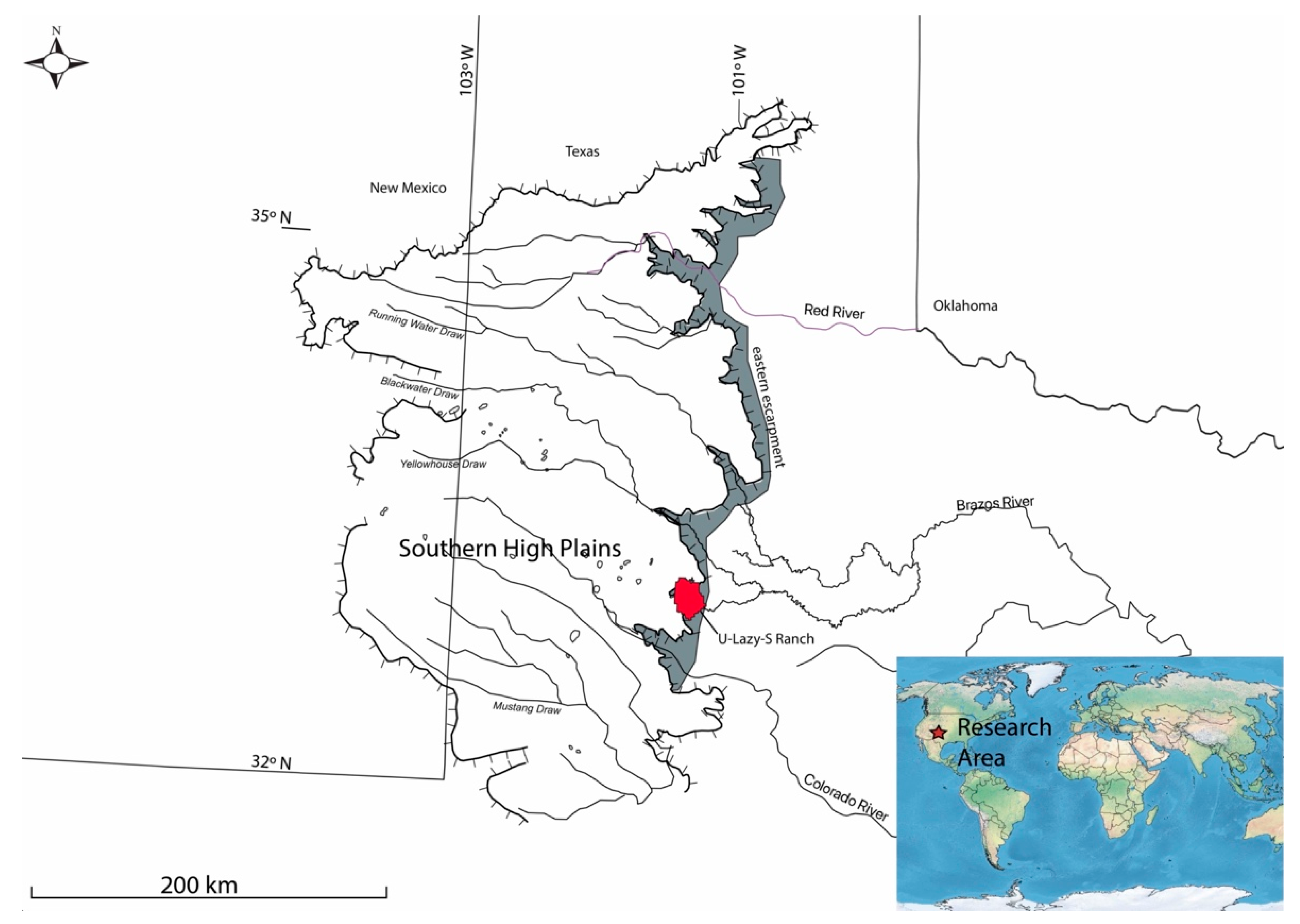
The U-Lazy-S Ranch (335 km
2) is within the Southern portion of the Great Plains physiographic region [
45] and, locally, at the topographic boundary between the Llano Estacado (Southern High Plains) and Rolling Plains (
Figure 1). The Llano Estacado is a flat, expansive landscape. This plateau is defined by escarpments along three sides—while to the south, the Llano Estacado merges with the Edwards Plateau (Stockton Plateau section) without an obvious break. About 25,000 freshwater playas (small lake basins) and 40 brackish salinas dot the upland surface [
46]. Northwest-southeast trending draws (river valleys) are tributaries of the Red, Brazos, and Colorado rivers that flow across the Rolling Plains and into the Gulf of Mexico. Constructional and erosional events of the Ogallala Formation (Miocene-Pliocene) have shaped the configuration of the Llano Estacado. The highly resistant pedogenic calcrete (~2 m thick) at the top of the Ogallala Formation is a primary factor in the size and configuration of the Llano Estacado. This calcrete is known regionally as the caprock [
47]. Below the caprock edge, the escarpments are broken up by steep canyons (escarpment breaks).
The modern climate is continental and semi-arid. Precipitation varies significantly on an annual basis ranging from 130 mm to 1010 mm, but with a mean annual precipitation of 480 mm [
48]. Precipitation occurs mainly as spring and summer thunderstorms producing short episodes of heavy rain [
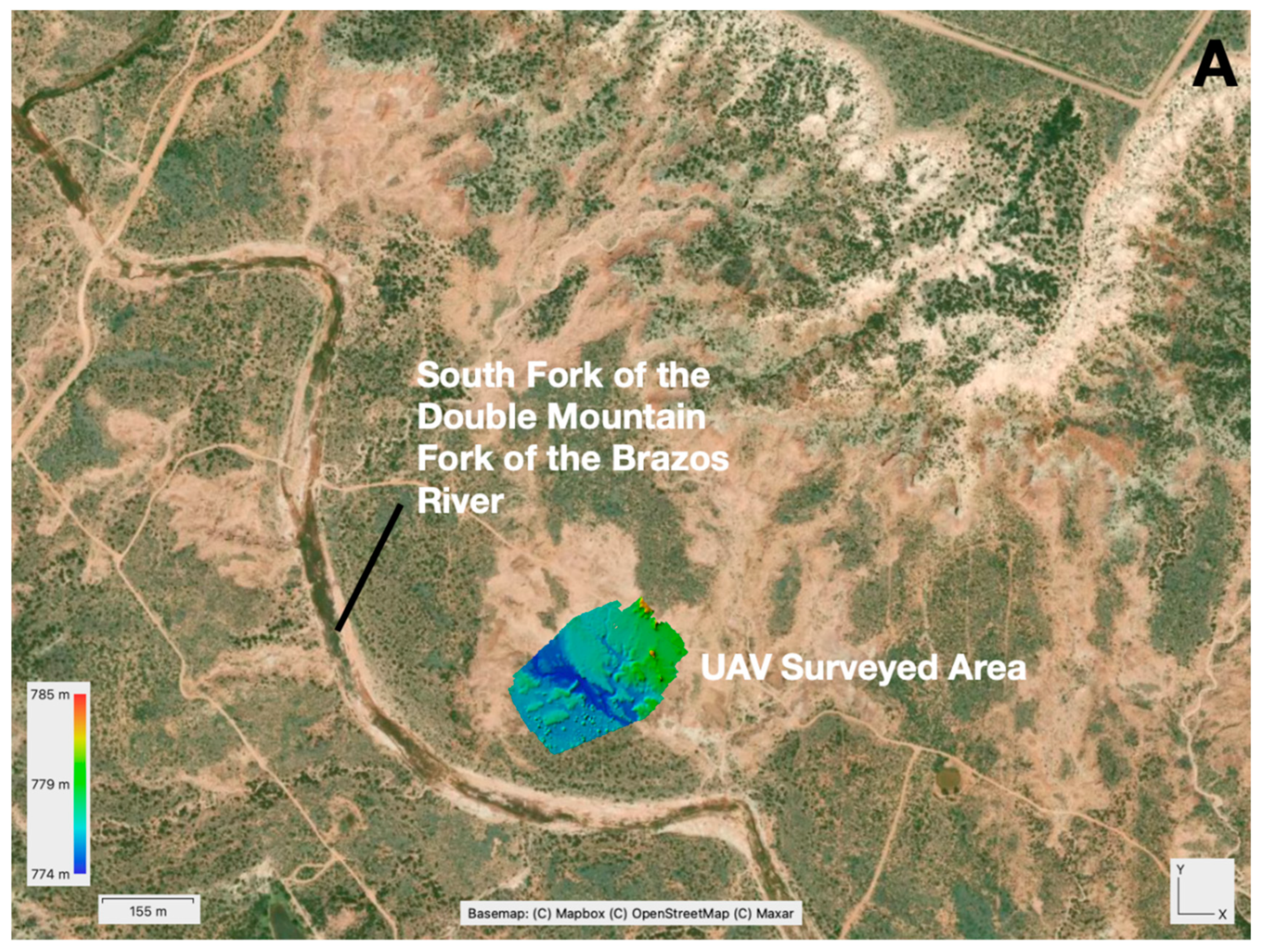
49]. The South Fork of the Double Mountain Fork of the Brazos River (hereafter South Fork) flows northwest to southeast through the U-Lazy-S Ranch (
Figure 2). Water primarily is supplied to the South Fork through spring-fed tributaries emanating out of the escarpment breaks. Run-off from heavy rains, however, increases the flow of the tributaries and river, and can cause flooding and erosion.
3.1. History of the U-Lazy-S Ranch
The Comanche (historic indigenous people) were removed from the region in 1874 through US military action [
50,
51], and the remaining herds of bison were hunted by buffalo hunters to near extinction by 1879 [
52]. Anglo-American cattle ranchers migrated into the region, establishing large ranches to take advantage of the vast grassland plains. In 1879, Jim and Finis Lindsey were the first to begin open-range cattle ranching on what would become the U-Lazy-S Ranch [
53]. Abraham Nave and James McCord purchased 1500 head of cattle and the range rights of the Lindseys in 1881 to establish the Nave-McCord Cattle Company and the Square and Compass Ranch. After two decades, the ranch was sold to J.B. Slaughter in 1901 to become the U-Lazy-S Ranch. Today, the historic U-Lazy-S Ranch is organized into four sections, each operated by different family members [
31].
3.2. Research on the U-Lazy-S Ranch: Rollie Burn’s Historic Cattle Water Tanks
As part of a broader agenda, survey and excavation of sites related to cattle ranching on the historic U-Lazy-S Ranch have been ongoing since 2008. Several types of ranching-related sites have been found: a ranch headquarters; dugouts; campsites, historical scatters; a roundup camp [
18]; windmills; tanks; fence lines, and pens (corrals). Historical records and family memory have provided some information on ranch-related sites [
31]. Knowledge of many peripheral places, however, has been lost and not documented.
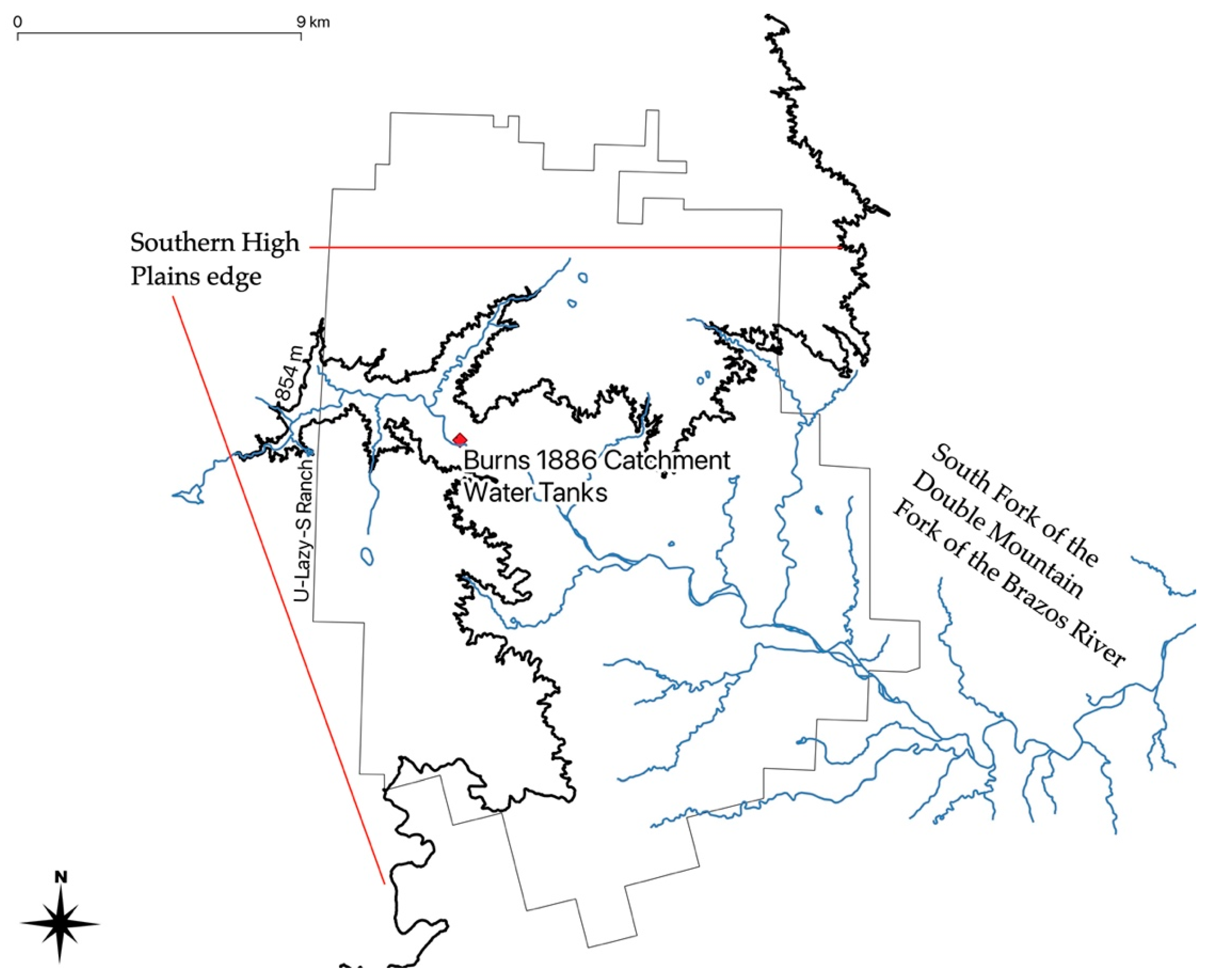
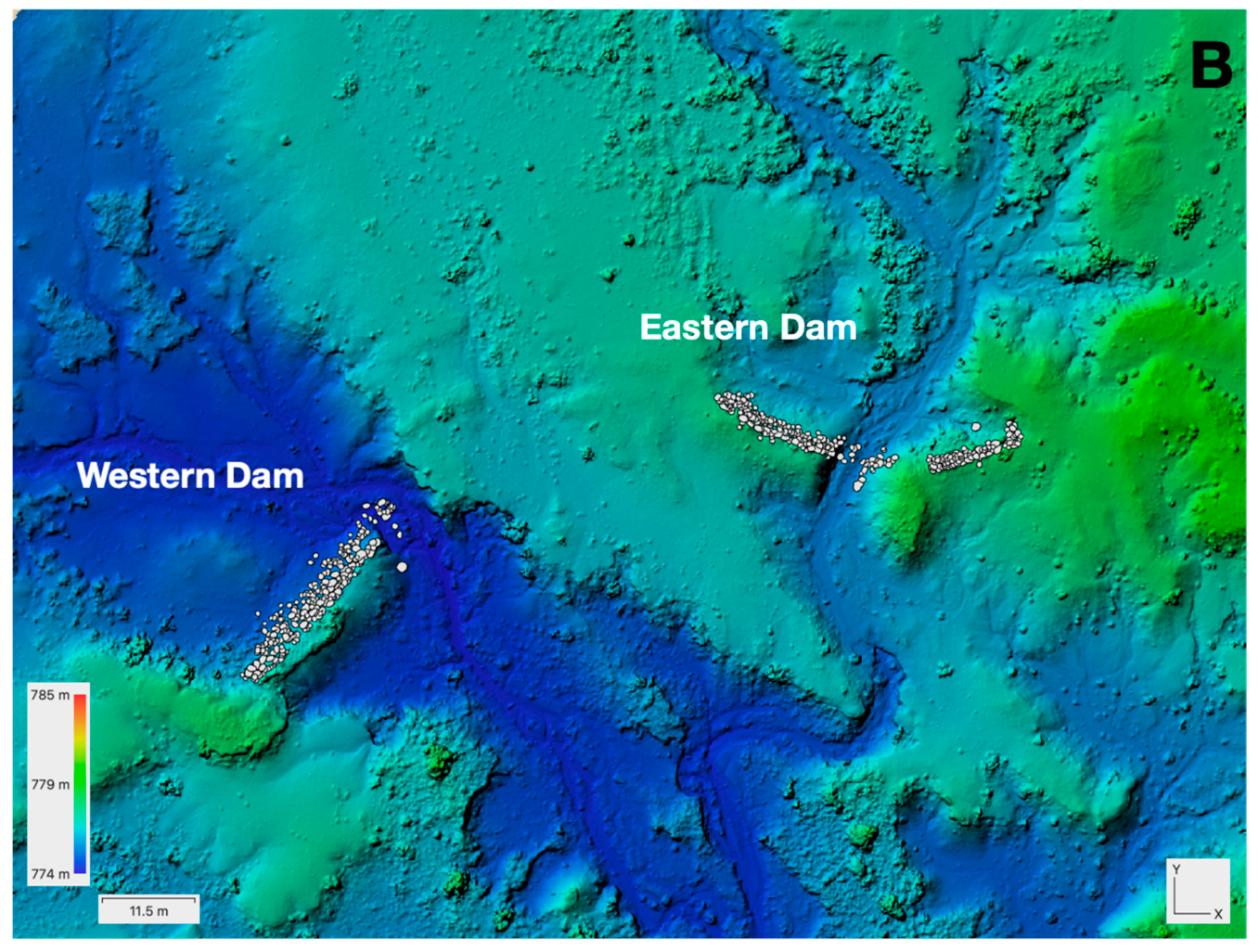
Two historical water tanks (Macy Locality 377; 41GR730) were found on survey in the South Fork’s flood plain and 250 m north of the present-day channel (
Figure 3). Both were catchment tanks. The dams were constructed within two different but adjacent waterways (62 m distance between dams), relying upon the local topography, to catch water runoff. A metal detector survey of the area failed to find an associated campsite or related objects.
Rollie Burns, a former cowboy and ranch manager (1884–1888) of the Square and Compass Ranch noted in his historical account [
13] (pp. 144–145) that he supervised the construction of water tanks in the fall of 1886 after a severe summer drought almost dried up all of the springs. Burns recounted [
43] “The Double Mountain Fork, which traversed the ranch from west to east, always had holes of water in it which had never before gone dry, and there were a number of spring creeks which rose at the Caprock and flowed into the Double Mountain…I had to keep several men busy scraping holes in the sandy bed of the river with teams and scrapers…That fall and winter, I induced the owners to build two large tanks on arroyos in the breaks of the big pasture and a small tank on a little spring draught in the horse pasture” (pp. 144–145).
Although no direct archaeological evidence was found, the two historical cattle water tanks are likely the same ones mentioned by Rollie Burns. First, the Square and Compass Ranch was the first in the region to build ranching infrastructure. Second, shortly after the drought of 1886, the Square and Compass Ranch began drilling wells and using windmills to tap underground sources of water to augment their surface water tanks [
43] (p. 145). The construction of new surface water tanks during that time period was likely less common. Third, the two tanks were constructed within the South Fork that is the same location mentioned by Rollie Burns which he refers to as the Double Mountain Fork.
4. Methodology
A DJI Inspire 1 UAV with a 16 megapixel (4600 × 2584) Zenmuse X5 camera was used to capture a total of 332 images in five flights. The UAV was controlled manually with images overlapping each other between 40–60%. Forty-five close-up images were shot at 10 m, 109 images were captured at 50 m, and 181 images were shot at 70 m above the ground surface. The total area covered by the UAV survey was 47,397.691 m2. Approximately two hours were needed to complete the UAV survey of the site.
The images were imported into Agisoft Metashape 1.7.1 for photogrammetric processing using a 2019 Apple Macbook Pro with a 2.4 ghz 8-core i9 Intel processor and 32 GB of DD4 RAM. In the first step, the alignment step, the following parameters were used: accuracy (highest), generic preselection (yes), reference preselection (source), key point limit (60,000), tie point limit (40,000), guided image matching (no), and adaptive camera model fitting (no). The images were aligned in 17 min and 11 s producing a total of 1,834,117 points. A dense cloud consisting of 108,573,704 points was created in the second step using Metashape’s following parameters: quality (high), filtering mode (aggressive). In the third step, a digital elevation model (DEM) and orthomosaic were created from the dense cloud. The computer required 2 min and 40 s to produce a DEM with a resolution of 2.22 cm per pixel. Interpolation was enabled in Metashape’s settings in processing the DEM. In constructing the orthomosiac, the following parameters were used: blending mode (average), enable hole filling (yes). The computer created the orthomosiac in 40 min and 9 s with a 1.11 cm per pixel resolution.
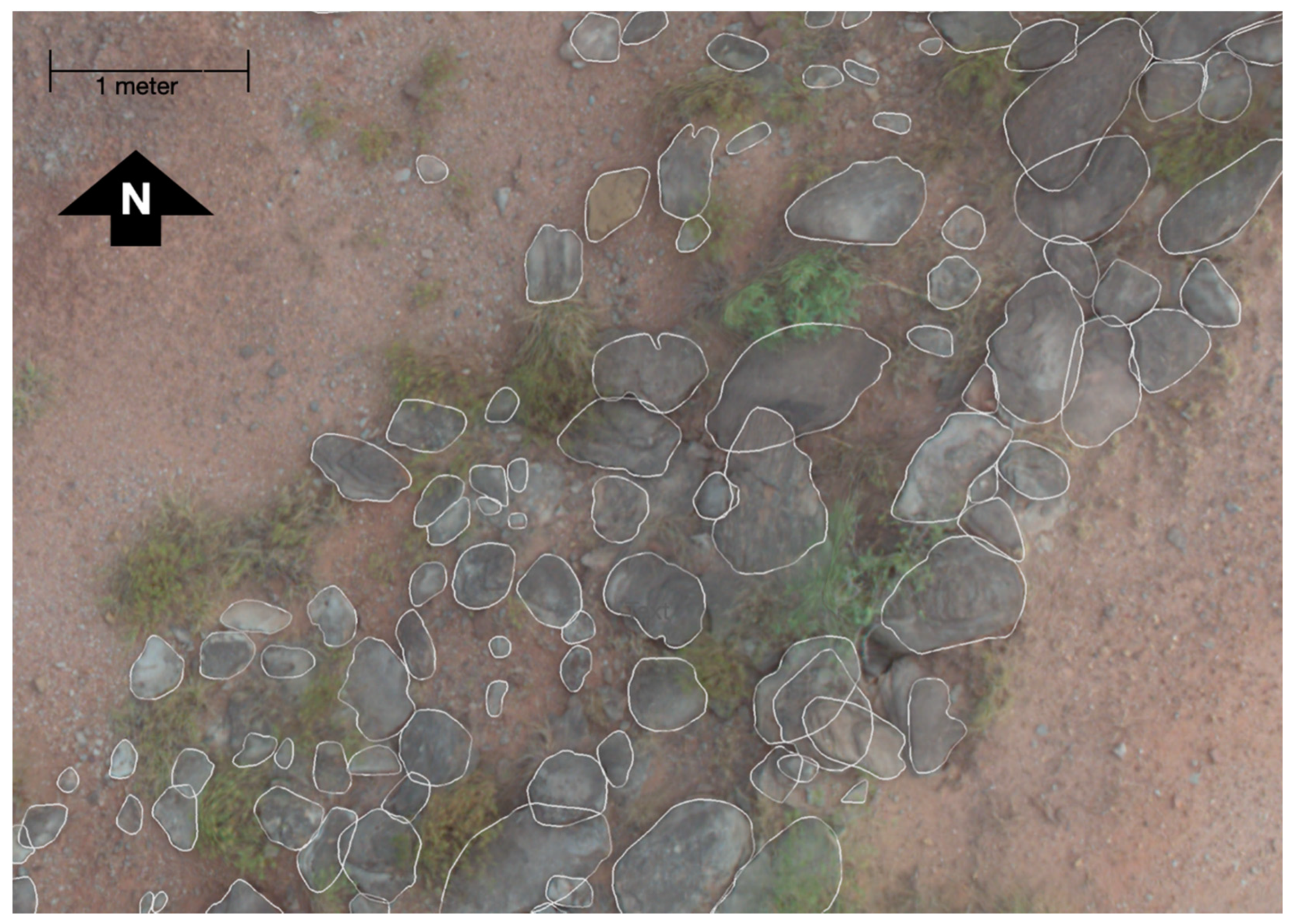
The size of the dams was measured using Metashape’s ruler and shape tools. In addition, these tools were used to estimate the volume of the tanks and amount of sediment needed to construct the dams. Each sandstone rock placed on the dam’s wall to prevent erosion was drawn and documented over two days using Metashape’s polygon tool (
Figure 4).
The DEM, orthomosaic, and sandstone rock shape layers then were exported for further study within the GIS software QGIS version 3.16. QGIS’s field calculator was used to determine the area and perimeter measurements for each sandstone rock. QGIS also was used to examine the size distribution of the sandstone rock across the two dams.
5. Results
The UAV-based photogrammetry model provided high-resolution data to record the size and shape and construction features of both water catchment tanks (
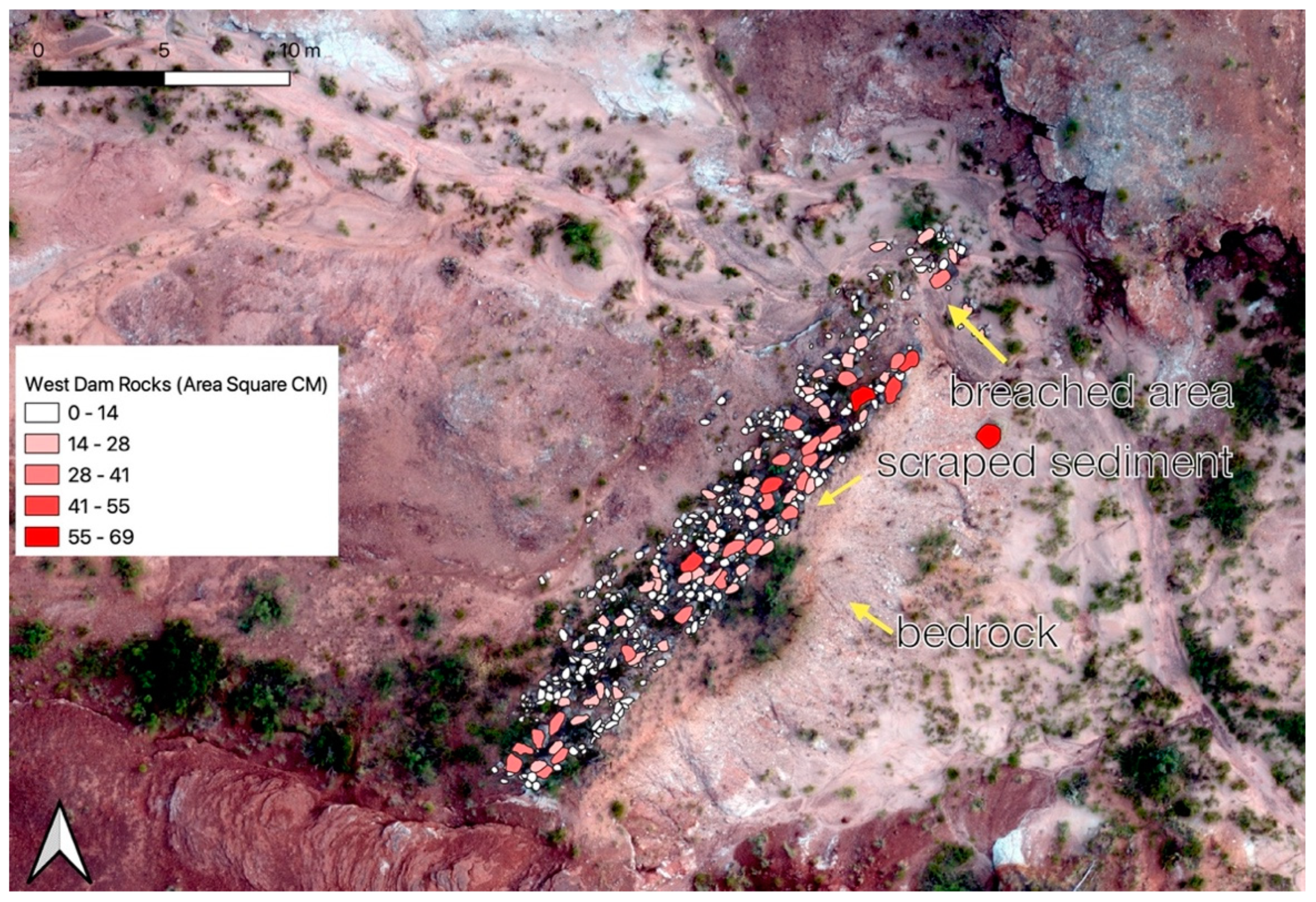
Figure S1). The western dam measured 23.3 m in length (
Figure 5). A breach in the dam eroded a 6.24 m segment on the eastern side. The total span of the dam when it was in operation would have been at least 29.54 m. Local sandstone rock from the Triassic-age Dockum Group [
54], available within 20 m, was placed on the inner wall of the dam. A total of 409 pieces of sandstone remained along the dam’s wall.
The western dam was built along the narrowest portion of the waterway, taking advantage of the local topography created by the exposed Triassic bedrock. Based on the waterway’s current dimensions, this catchment tank would have been ~4122 m2 in size, and held ~8614 m3 of water. The dam that remains was composed mainly of an eroded remnant of the underlying Triassic bedrock. Approximately 226 m3 of additional sediment from the sediment from the bottom of the waterway was scraped and added to the bedrock to form this dam section. In cross-section, the dam had an elevation change of approximately 1.5 m from the base of the dam to the top with a 61.5° slope. The dam’s 6.24 m erosional gap was the only portion of the dam that would not have contained underlying bedrock support. This part of the dam built from ~170.49 m3 of scraped sediment was the weakest section and more prone to erosion.
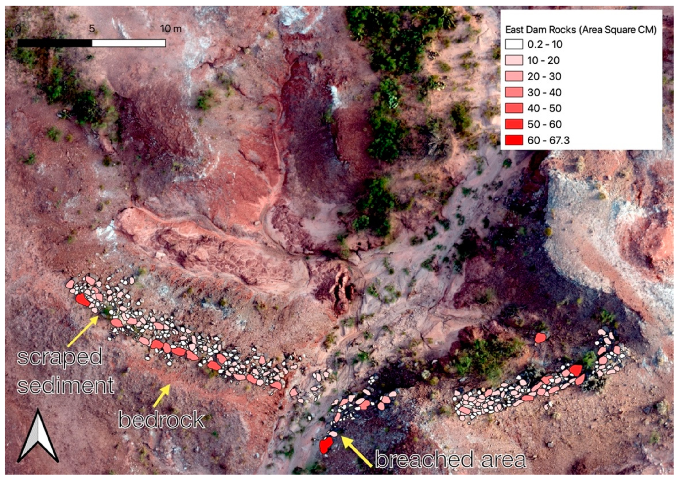
In contrast to the western dam, the eastern dam was breached in the middle removing a 6.05 m long segment (
Figure 6). The remaining western half measured 16.1 m in width, and the eastern half 18.5 m. The total dimension of the dam, including the missing eroded segment, would have been 40.65 m. Sandstone rock was added to this dam’s wall, available within a 20 m area, and 460 pieces remained along the dam’s wall.
Like the western dam, the eastern dam was built along the narrowest part of the waterway. In cross section, the eastern dam had an elevation change of approximately 1.2 m from the base of the dam to the top with a slope of 40°. This catchment tank would have been ~2681 m2 in size and held ~4036 m3 of water—half the size of the western tank. No scraped sediment from the waterway’s bottom was found on either half of the eastern dam. Like the western dam, the eastern dam’s middle missing section would have been constructed from ~231.35 m3 of scraped sediment and was the weakest part of the dam and susceptible to erosion.
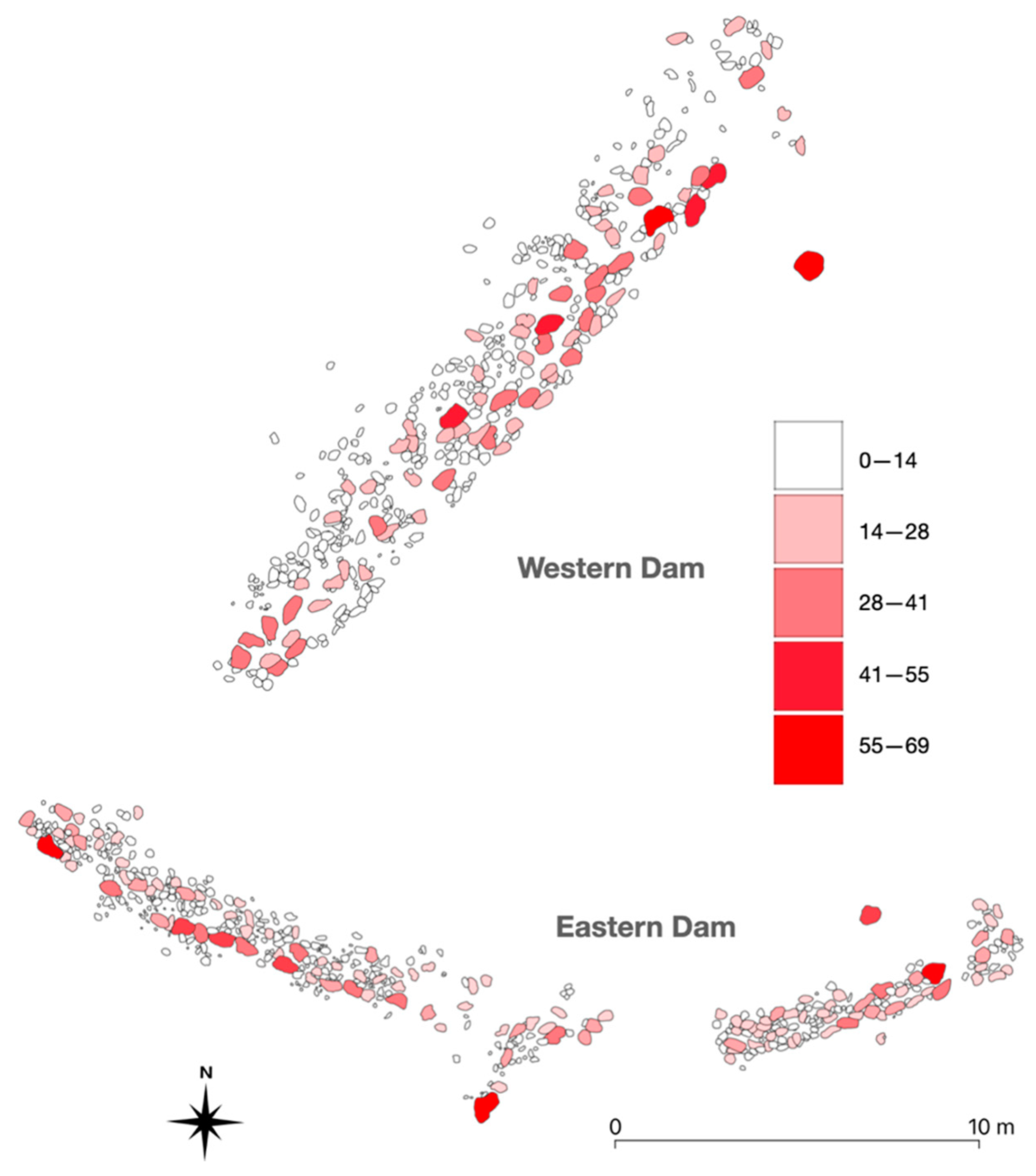
A total of 869 pieces of sandstone rock were documented on the walls of both tanks. The sandstone rock’s average size (area cm
2) and their distribution across the dam walls were examined. The size of sandstone rock used for both of the dam’s walls was very similar (
Table 1). The average size of rock used for the western dam was 9.11 cm
2, only slightly larger than those used for the eastern dam, that were, on average, 8.16 cm
2. The range in the size of the rock used for both dams was between 0.25 to 69 cm
2. A two-pair
t-test found that the size of the sandstone rock used for both dams was not statistically different (
p-value of 0.133).
The distribution of where the larger size sandstone rocks were placed in relationship to the smaller rocks also is similar across both dams (
Figure 7). It appears that the cowboys attempted to spread out the large size rocks to cover both dams evenly. Smaller size rocks then were placed in-between the larger rocks. The similarity in size and how the sandstone rocks were placed across both of the dam walls suggest both were created at the same time.
A few of the sandstone rocks have moved over the last 120 years from erosion. The eastern dam contains a section of rocks that eroded downslope after the breach and erosion of the dam’s middle section. The western dam contains a section of rock that eroded downslope after the erosion of that dam’s eastern side.
6. Discussion
In traditional methods of documentation, a map is compiled in the field using a total station for determining location, a tape measure, and drawing objects by hand on graph paper. In this case, several individuals over multiple days would have been needed to document both historical water tanks. The amount of time and people needed to record surface water tanks fully is likely an important reason why these features frequently are only mentioned and not analyzed in survey reports.
In this research, the results demonstrate that UAV-photogrammetry can document rapidly and provide high-resolution records of historical cattle ranching features. The documentation generated in this study includes over 100 million individual 3D data points, a 3D model, and an orthomosiac and DEM for GIS interpretation. The raw data for this comprehensive data set were collected in the field in ~two hours, and processed by the Metashape software in ~five hours. Mapping of the rocks took an individual two days to complete in the lab. This method reduced both field and personnel time and expense, allowed for high resolution data, and provided a viable option to move beyond the mention of the presence of tanks to their recording and analysis. Researchers could use these data to justify incorporating the recording and analysis of water tanks and other peripheral ranching features into survey plans. These data also are a basis for the comparison of how other historical water tanks were constructed worldwide (
Figure S1). In addition, researchers can 3D model the water tanks in the future to compare with this dataset for documenting landscape change and its impact on the water tank dam’s preservation.
Data were used to examine the method of dam construction. The dimensions of the catchment walls and the tank’s water catchment area estimated size were compared. The size of sandstone rocks and how they were placed across the tank’s walls were analyzed using GIS. The results indicated that the size of sandstone rocks and how the rocks were placed across both dams were similar. Both dams appeared to have been constructed at the same time as indicated by Rollie Burns in his historical account [
43] (pp. 144–145).
The placement of both dams was made to take advantage of the local topography. Not much sediment had to be scraped to form the majority of the walls of both tanks. The breached sections of both dams consisted of only scraped sediment that was more susceptible to erosion—the sections underlined by bedrock remained intact.
These two surface water catchment tanks are the oldest on the ranch and were likely maintained only for a few years. Improvements in drilling technology to tap underground sources of water and the use of windmills allowed ranchers to construct tanks to supply water for cattle as needed throughout the ranch. Ranchers today still create and maintain surface water catchment tanks. The task of creating these tanks, however, is made easier with modern earth-moving equipment.
7. Conclusions
Archaeological research related to cattle ranching (e.g., [
55]) has not been able to keep up with the loss of information over the last century [
44,
56,
57]. UAV-based photogrammetry, used in this research, has documented cattle-related features rapidly in high detail useful in digital heritage preservation and archaeological research. This approach is cost-effective both in the field and during analysis.
The use of aerial photogrammetry is optimal in semi-arid to arid landscapes that contain less vegetation [
4]. Historical cattle ranches typically have developed in these landscapes because the landscapes often are associated with a grassland ecosystem [
14]. UAV-photogrammetry, therefore, is an important method that can be integrated into archaeological surveys to record and analyze cattle ranching features (e.g., [
3]) rapidly for heritage preservation and archaeological research. Other technologies such as laser scanning are more appropriate in regions of the world with more rainfall and vegetation [
58,
59,
60].
Author Contributions
Conceptualization, S.H.; methodology, S.H.; software, S.H.; validation, E.J., formal analysis, S.H., G.F.-C.; investigation, D.C., S.H.; resources, E.J.; data curation, E.J.; writing—original draft preparation, S.H.; writing—review and editing, E.J.; visualization, G.F.-C.; supervision, S.H., D.C.; project administration, E.J.; funding acquisition, E.J., S.H. All authors have read and agreed to the published version of the manuscript.
Funding
This research received no external funding.
Institutional Review Board Statement
Not applicable.
Informed Consent Statement
Not applicable.
Data Availability Statement
All data are housed at the Museum of Texas Tech University and available for viewing on SketchFab.
Acknowledgments
The authors thank the landowner for graciously allowing us access to the ranch. This research was funded by the Museum of Texas Tech University and two Texas Tech University scholastic catalyst grants (2015, 2017). This manuscript represents part of the ongoing Lubbock Lake Landmark regional research into cultural landscape use strategies on the Llano Estacado. The authors thank the anonymous reviewers for their helpful comments.
Conflicts of Interest
The authors declare no conflict of interest.
References
- Nikolakopoulos, K.G.; Soura, K.; Koukouvelas, I.K.; Argyropoulos, N.G. Uav Vs Classical Aerial Photogrammetry for Archaeological Studies. J. Archaeol. Sci. Rep. 2017, 14, 758–773. [Google Scholar] [CrossRef]
- Jorayev, G.; Wehr, K.; Benito-Calvo, A.; Njau, J.; de la Torre, I. Imaging and Photogrammetry Models of Olduvai Gorge (Tanzania) by Unmanned Aerial Vehicles: A High-Resolution Digital Database for Research and Conservation of Early Stone Age Sites. J. Archaeol. Sci. 2016, 75, 40–56. [Google Scholar] [CrossRef]
- Magnani, M.; Douglass, M.; Schroder, W.; Reeves, J.; Braun, D.R. The Digital Revolution to Come: Photogrammetry in Archaeological Practice. Am. Antiq. 2020, 85, 737–760. [Google Scholar] [CrossRef]
- Vavulin, M.V.; Chugunov, K.V.; Zaitceva, O.V.; Vodyasov, E.V.; Pushkarev, A.A. Uav-Based Photogrammetry: Assessing the Application Potential and Effectiveness for Archaeological Monitoring and Surveying in the Research on the ‘Valley of the Kings’ (Tuva, Russia). Digit. Appl. Archaeol. Cult. Herit. 2021, 20, e00172. [Google Scholar] [CrossRef]
- Bakirman, T.; Bayram, B.; Akpinar, B.; Karabulut, M.F.; Bayrak, O.C.; Yigitoglu, A.; Seker, D.Z. Implementation of Ultra-Light Uav Systems for Cultural Heritage Documentation. J. Cult. Herit. 2020, 44, 174–184. [Google Scholar] [CrossRef]
- Seitz, C. Combined Aerial and Ground-Based Structure from Motion for Cultural Heritage Documentation. In Digital Geoarchaeology; Siart, C., Forbriger, M., Bubenzer, O., Eds.; Springer International Publishing: Cham, Switzerland, 2017; pp. 149–163. [Google Scholar]
- Berquist, S.; Spence-Morrow, G.; Gonzalez-Macqueen, F.; Rizzuto, B.; Álvarez, W.Y.; Bautista, S.; Jennings, J. A New Aerial Photogrammetric Survey Method for Recording Inaccessible Rock Art. Digit. Appl. Archaeol. Cult. Herit. 2018, 8, 46–56. [Google Scholar] [CrossRef]
- Orengo, H.A.; Garcia-Molsosa, A. A Brave New World for Archaeological Survey: Automated Machine Learning-Based Potsherd Detection Using High-Resolution Drone Imagery. J. Archaeol. Sci. 2019, 112, 105013. [Google Scholar] [CrossRef]
- Casana, J.; Kantner, J.; Wiewel, A.; Cothren, J. Archaeological Aerial Thermography: A Case Study at the Chaco-Era Blue J Community, New Mexico. J. Archaeol. Sci. 2014, 45, 207–219. [Google Scholar] [CrossRef]
- Casana, J.; Laugier, E.J.; Hill, A.C.; Blakeslee, D. A Council Circle at Etzanoa? Multi-Sensor Drone Survey at an Ancestral Wichita Settlement in Southeastern Kansas. Am. Antiq. 2020, 85, 761–780. [Google Scholar] [CrossRef]
- Megarry, W.; Graham, C.; Gilhooly, B.; O’Neill, B.; Sands, R.; Nyland, A.; Cooney, G. Debitage and Drones: Classifying and Characterising Neolithic Stone Tool Production in the Shetland Islands Using High Resolution Unmanned Aerial Vehicle Imagery. Drones 2018, 2, 12. [Google Scholar] [CrossRef]
- Smith, S.L. Drones over the “Black Desert”: The Advantages of Rotary-Wing Uavs for Complementing Archaeological Fieldwork in the Hard-to-Access Landscapes of Preservation of North-Eastern Jordan. Geosciences 2020, 10, 426. [Google Scholar] [CrossRef]
- Holden, W.C. Alkali Trails, or, Social and Economic Movement of the Texas Frontier 1846–1900; Texas Tech University Press: Lubbock, TX, USA, 1930. [Google Scholar]
- Webb, W.P. The Great Plains; Grosset & Dunlap: New York, NY, USA, 1931. [Google Scholar]
- Bolton, H.E. The Spanish Borderlands: A Chronicle of Old Florida and the Southwest; Yale University Press: New Haven, CT, USA, 1921. [Google Scholar]
- Faulk, O.B. Ranching in Spanish Texas. Hisp. Am. Hist. Rev. 1965, 45, 257–266. [Google Scholar] [CrossRef] [Green Version]
- Savage, W.W., Jr. Cowboy Life; University of Oklahoma Press: Norman, OK, USA, 1975. [Google Scholar]
- Hurst, S.; Ward, D.C.; Johnson, E.; Cunningham, D. Cowboy Life Along the Llano Estacado Eastern Escarpment of Northwest Texas: Insights from Macy Locality 16 (41gr722). Hist. Archaeol. 2018, 52, 332–347. [Google Scholar] [CrossRef]
- Dixon, K.J. Historical Archaeologies of the American West. J. Archaeol. Res. 2014, 22, 177–228. [Google Scholar] [CrossRef] [Green Version]
- Fischer, J.R. Cattle in Hawai’i: Biological and Cultural Exchange. Pac. Hist. Rev. 2007, 76, 347–372. [Google Scholar] [CrossRef]
- Head, L.; Fullagar, R. Hunter-Gatherer Archaeology and Pastoral Contact: Perspectives from the Northwest Northern Territory, Australia. World Archaeol. 1997, 28, 418–428. [Google Scholar] [CrossRef]
- Mills, P.R.; White, C.L.; Barna, B. The Paradox of the “Paniolo”: An Archaeological Perspective of Hawaiian Ranching. Hist. Archaeol. 2013, 47, 110–132. [Google Scholar] [CrossRef]
- McGrath, A. Born in the Cattle: Aboriginies in Cattle Country; Allen & Unwin: Sydney, Australa, 1987. [Google Scholar]
- Slatta, R.W. Comparing Cowboys and Frontiers; University of Oklahoma Press: Norman, OK, USA, 1997. [Google Scholar]
- Silliman, S.W. Lost Laborers in Colonial California: Native Americans and the Archaeology of Rancho Petaluma; University of Arizona Press: Tucson, AZ, USA, 2004. [Google Scholar]
- Kornfeld, M. A Model of High Plains and Intermountain Stockraising Settlement Systems. N. Am. Arch. 1983, 4, 51–62. [Google Scholar] [CrossRef]
- Guyer, J.S. Pioneer Life in West Texas; James S. Guyer: Brownwood, TX, USA, 1938. [Google Scholar]
- Ward, F.E. The Cowboy at Work: All About His Job and How He Does It; Hastings House: New York, NY, USA, 1958. [Google Scholar]
- Holden, W.C. The Espuela Land and Cattle Company: A Study of a Foreign-Owned Ranch in Texas; Texas State Historical Association: Austin, TX, USA, 1970. [Google Scholar]
- Engel, P.M. Towards an Archaeology of Ranching on the Point Reyes Pennisula. Master’s Thesis, Sonoma State University, Rohnert Park, CA, USA, 2012. [Google Scholar]
- Ward, D. A Heritage Perspective on the Historic U-Lazy-S Ranch—A Case Study in Heritage Construction. Master’s Thesis, Texas Tech University, Lubbock, TX, USA, 2016. [Google Scholar]
- Hardesty, D.L. The Archaeology of Mining and Miners; Society for Historical Archaeology: Ann Arbor, MI, USA, 1988. [Google Scholar]
- Hardesty, D.L.; Little, B.J. Assessing Site Significance; Altimira Press: Plymouth, UK, 2009. [Google Scholar]
- Panich, L.M.; Schneider, T.D. Expanding Mission Archaeology: A Landscape Approach to Indigenous Autonomy in Colonial California. J. Anthropol. Res. 2015, 40, 48–58. [Google Scholar] [CrossRef] [Green Version]
- McHugh, W.P. Cattle Pastoralism in Africa—A Model for Interpreting Archaeological Evidence from the Eastern Sahara Desert. Arc. Anthropol. 1974, 11, 236–244. [Google Scholar]
- Neuendorf, K.K.E.; James, P.; Mehl, J.; Jackson, J.A. (Eds.) Glossary of Geology; American Geological Institute: Alexandria, VA, USA, 2011. [Google Scholar]
- Crown, P.L. Water Storage in the Prehistoric Southwest. Kiva 1987, 52, 209–228. [Google Scholar] [CrossRef]
- Rollins, P.A. The Cowboy: His Characteristics, His Equipment, And His Part in the Development of the West; Carles Scribner’s Sons: New York, NY, USA, 1924. [Google Scholar]
- McDaniel, A.B. Excavation: Machinery, Methods and Costs; McGraw-Hill Book Company: New York, NY, USA, 1919. [Google Scholar]
- Jordan, T.G. Windmills in Texas. Agric. Hist. 1963, 37, 80–85. [Google Scholar]
- Sayre, N.F. A History of Working Landscapes: The Altar Valley, Arizona, USA: How Ranchers Have Shaped the West—and Continue to Do So. Rangelands 2007, 29, 41–45. [Google Scholar] [CrossRef] [Green Version]
- Murray, T. Towards and Archaeology of Extensive Pastoralism in the Great Artesian Basin in Australia. In Historical Archaeology and Enviornment; Torres de Souza, M.A., Costa, D.i.M., Eds.; Springer: Cham, Switzerland, 2018; pp. 109–128. [Google Scholar]
- Holden, W.C. Rollie Burns, or, an Account of the Ranching Industry on the South Plains, 2nd ed.; Texas A&M University Press: College Station, TX, USA, 1986; p. 243. [Google Scholar]
- Carrillo, R. Cultural Resources Survey of the Purgatoire River Region; Colorado Preservation, Inc.: Denver, CO, USA, 2011. [Google Scholar]
- Fenneman, N.M. Physiography of Western United States; McGraw-Hill Book Company: New York, NY, USA, 1931. [Google Scholar]
- Sabin, T.J.; Holliday, V.T. Playas and Lunettes on the Southern High Plains: Morphometric and Spatial Relationships. Ann. Assoc. Am. Geogr. 1995, 85, 286–305. [Google Scholar] [CrossRef]
- Johnson, E. Landscapes and Peoples of the Llano Estacado. In Archaeological Landscapes on the High Plains, Scheiber, L.L., Clark, B.J., Eds.; University Press of Colorado: Boulder, CO, USA, 2008; pp. 115–156. [Google Scholar]
- Bomar, G.W. Texas Weather; University of Texas Press: Austin, TX, USA, 1995. [Google Scholar]
- Harragan, D. Blue Northers to Sea Breezes: Texas Weather and Climate; Hendrick Long Publishing Company: Dallas, TX, USA, 1983. [Google Scholar]
- Wallace, E.; Hoebel, E.A. The Comanches: Lords of the South Plains, 1st ed.; University of Oklahoma Press: Norman, OK, USA, 1952. [Google Scholar]
- Cruse, J.B. Battles of the Red River War: Archeological Perspectives on the Indian Campaign of 1874; Texas A&M University Press: College Station, TX, USA, 2008; p. 272. [Google Scholar]
- Liles, J. A Historical Geographical Assessment of Bison Hunting on the Southern Great Plains in the 1870s. Master’s Thesis, Oklahoma State University, Stillwater, OK, USA, 2008. [Google Scholar]
- Didway, C. Wagon Wheels: A History of Garza County, 1st ed.; Pioneer Book Publishing: Seagraves, TX, USA, 1973; p. 340. [Google Scholar]
- Lehman, T.; Chatterjee, S. Depositional Setting and Vertebrate Biostratigraphy of the Triassic Dockum Group of Texas. J. E. Syst. Sci. 2005, 114, 325–351. [Google Scholar] [CrossRef]
- Fontana, B.L.; Greenleaf, J.C.; Ferguson, C.W.; Wright, R.A.; Frederick, D. Johnny Ward’s Ranch: A Study in Historic Archaeology. Kiva 1962, 28, 1–115. [Google Scholar] [CrossRef]
- Vlahos, E. Preserving the Cultural Landscapes of Ranching in the American West. In Getting Real: Design Ethos Now; Cheng, R., Tripeny, P.J., Eds.; Association of Collegiate Schools of Architecture: Washington, DC, USA, 2006; pp. 437–443. [Google Scholar]
- Vlahos, E. Preserving Ranches: Not Only Possible, but Imperative. CRM J. Herit. Steward. 2005, 2, 6–12. [Google Scholar]
- Roman, A.; Ursu, T.-M.; Lăzărescu, V.-A.; Opreanu, C.H.; Fărcaş, S. Visualization Techniques for an Airborne Laser Scanning-Derived Digital Terrain Model in Forested Steep Terrain: Detecting Archaeological Remains in the Subsurface. Geoarchaeology 2017, 32, 549–562. [Google Scholar] [CrossRef]
- Zhou, W.; Chen, F.; Guo, H.; Hu, M.; Li, Q.; Tang, P.; Zheng, W.; Liu, J.a.; Luo, R.; Yan, K.; et al. Uav Laser Scanning Technology: A Potential Cost-Effective Tool for Micro-Topography Detection over Wooded Areas for Archaeological Prospection. Int. J. Digit. Earth 2020, 13, 1279–1301. [Google Scholar] [CrossRef]
- Campana, S. Drones in Archaeology. State-of-the-Art and Future Perspectives. Archaeol. Prospect 2017, 24, 275–296. [Google Scholar] [CrossRef]
| Publisher’s Note: MDPI stays neutral with regard to jurisdictional claims in published maps and institutional affiliations. |
© 2021 by the authors. Licensee MDPI, Basel, Switzerland. This article is an open access article distributed under the terms and conditions of the Creative Commons Attribution (CC BY) license (https://creativecommons.org/licenses/by/4.0/).


