Mapping Cultural Heritage in Coastal Areas with UAS: The Case Study of Lesvos Island

 ,
,  ,
, 
 and
and 
Abstract
1. Introduction
2. State of the Art
3. Materials and Methods
3.1. Case Study Areas
3.1.1. The Ancient Harbor of Mytilene
3.1.2. The Ancient Harbor of Eresos
3.2. Unmanned Aerial Systems (UAS) Data Acquitition and Products
3.3. The Development of the Metadata Cataloging System
3.3.1. Requirements Analysis
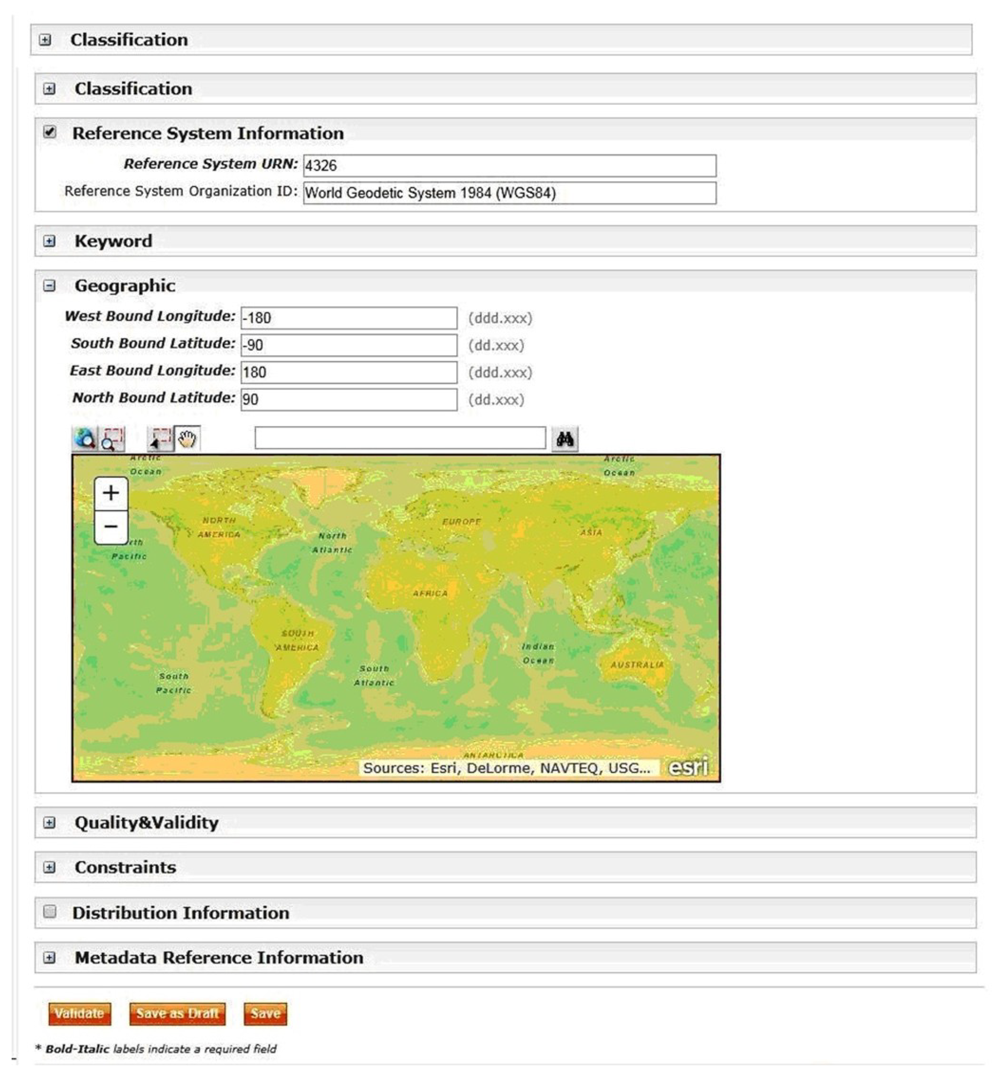
3.3.2. System Implementation
4. Results
4.1. Unmanned Aerial Systems-Structure from Motion (UAS-SfM) Products
4.2. Findings from the Orthophoto Maps
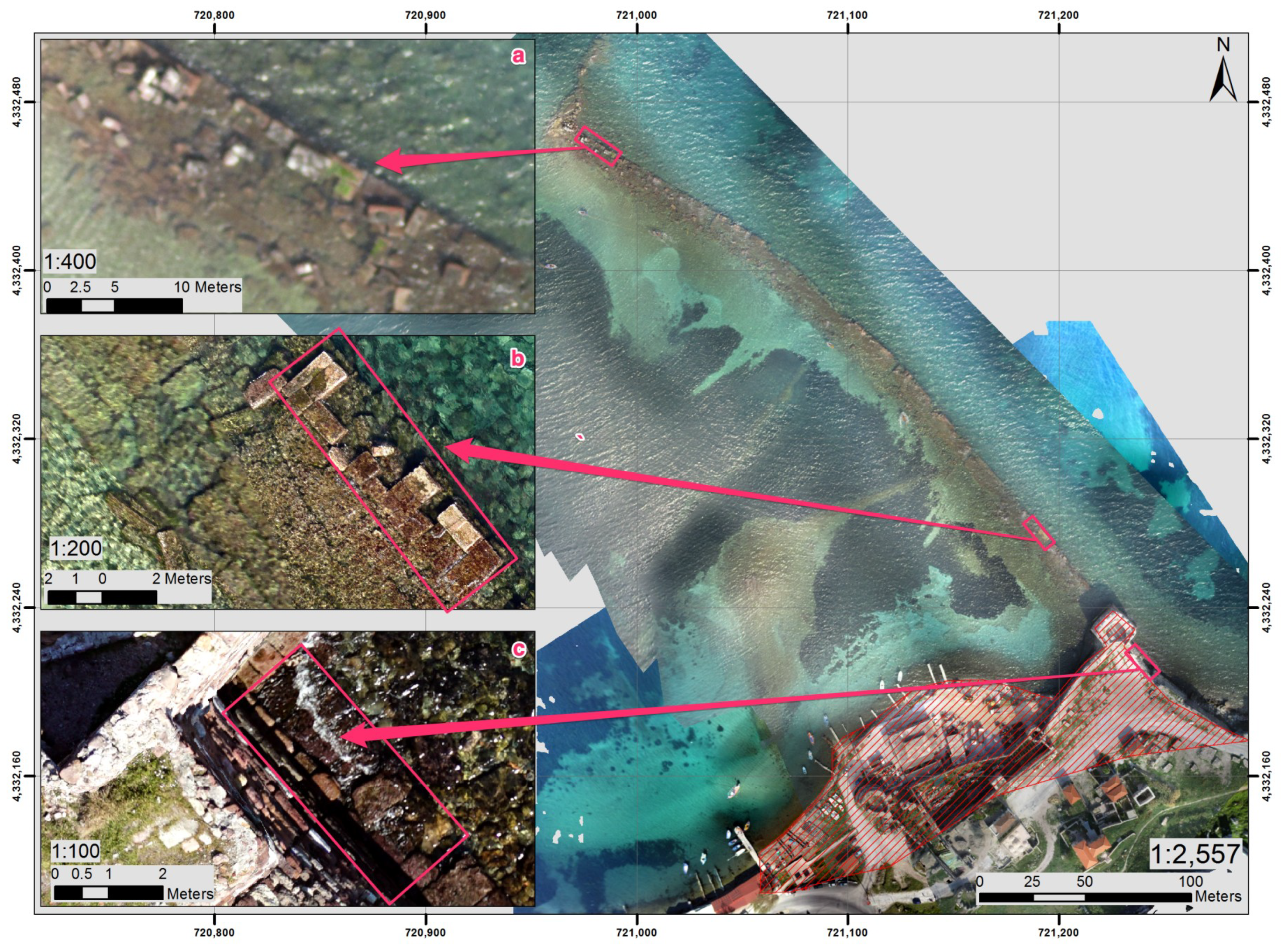
4.2.1. The Ancient Harbor of Mytilene
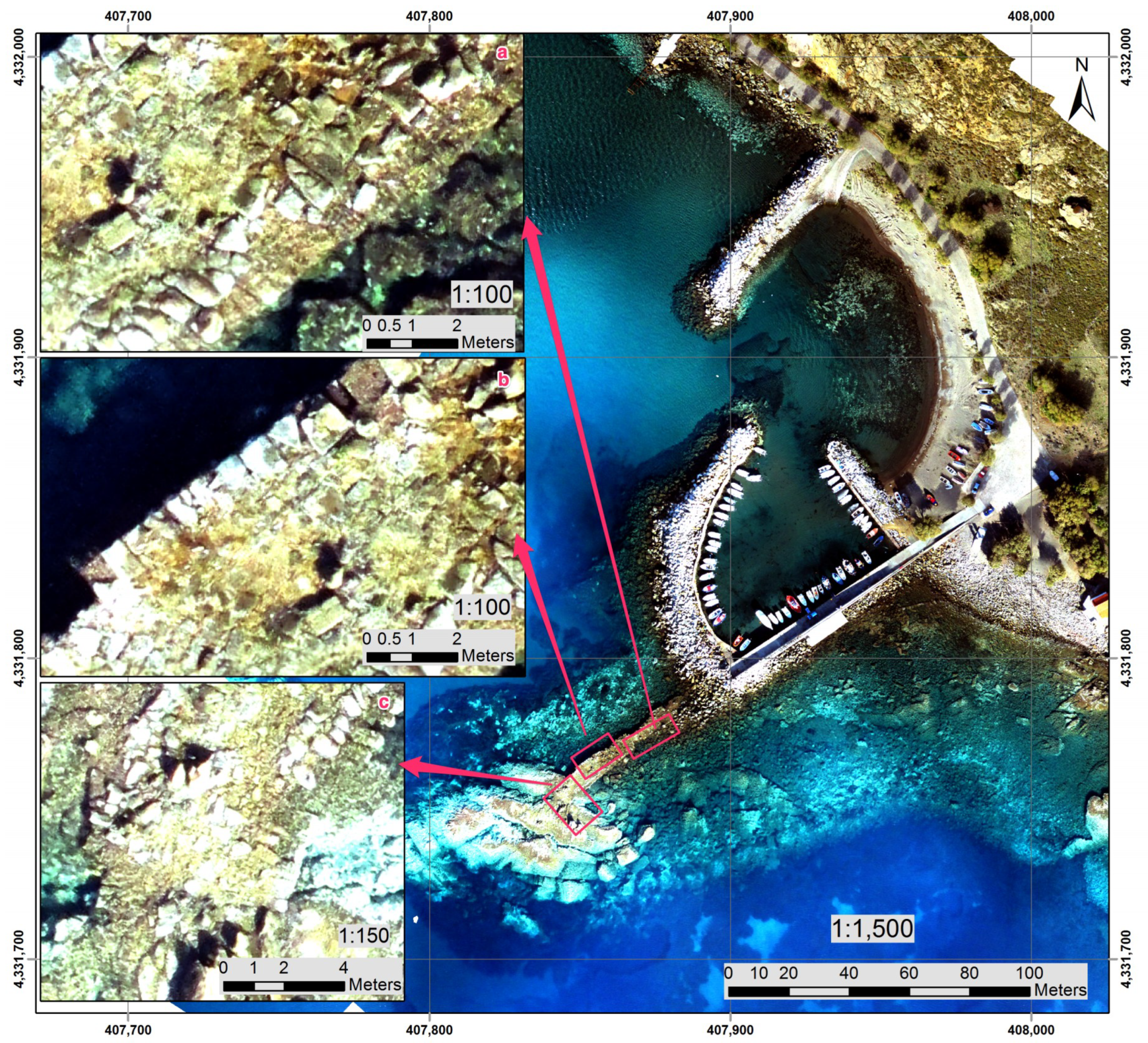
4.2.2. The Ancient Harbor of Eresos
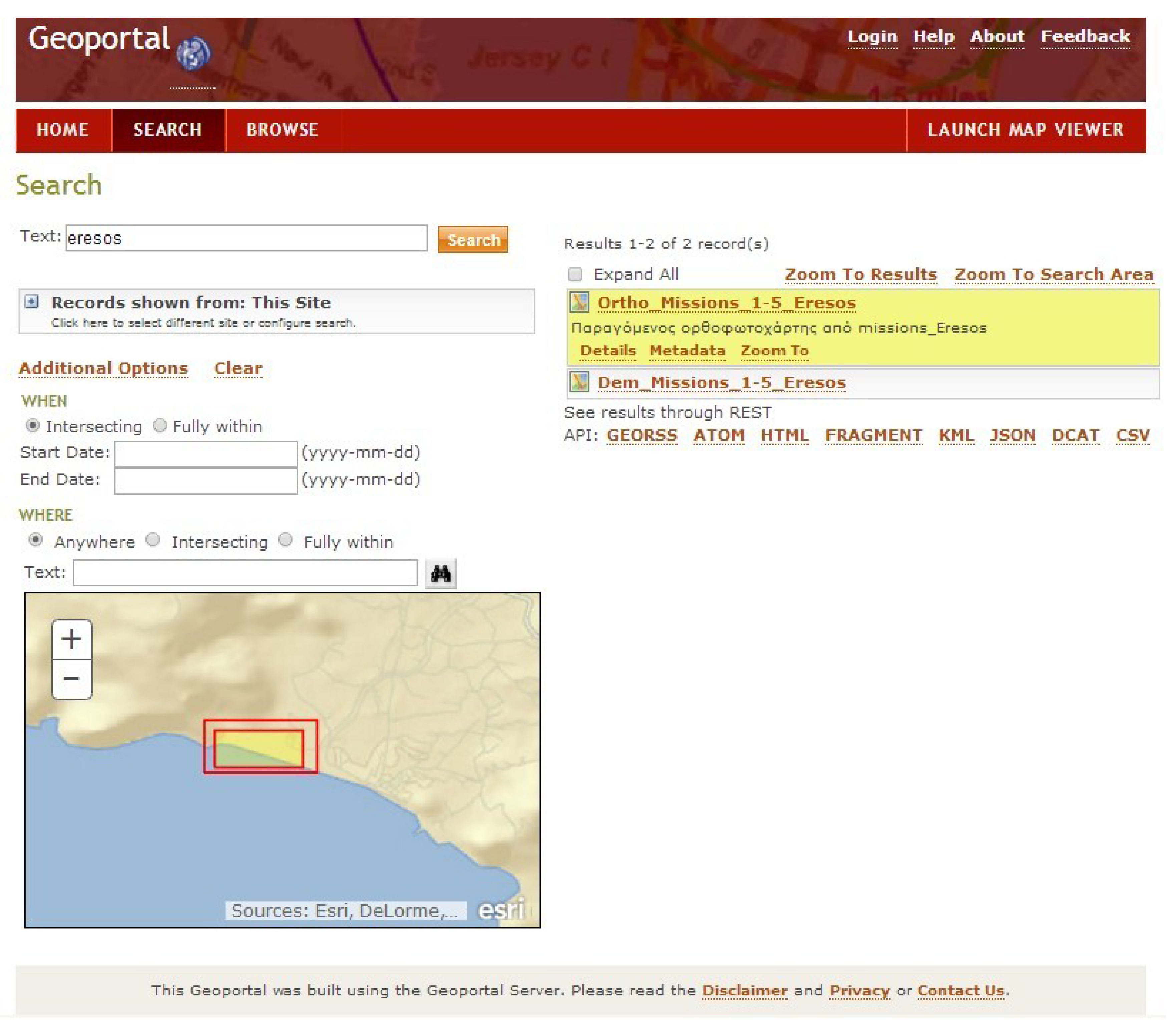
4.3. Cataloging System Functionality
5. Discussion
6. Conclusions
Author Contributions
Funding
Conflicts of Interest
References
- Ziegler, V. Anatomy of an Urban Design Project: Bordeaux New Garonne Riverbank. In New Faces of Harbour Cities; Dündar, Ş.G., Karataş, N., Erdin, H.E., Lorens, P., Dundar, S.G., Karatas, N., Eds.; Cambridge Scholars Publishing: Newcastle, UK, 2014; pp. 103–119. [Google Scholar]
- Franco, L. Ancient Mediterranean harbours: A heritage to preserve. Ocean Coast. Manag. 1996, 30, 115–151. [Google Scholar] [CrossRef]
- Blackman, D.J. Ancient harbours in the Mediterranean. Part 2. Int. J. Naut. Archaeol. 1982, 11, 185–211. [Google Scholar] [CrossRef]
- Blackman, D.J. Ancient harbours in the Mediterranean. Part 1. Int. J. Naut. Archaeol. 1982, 11, 79–104. [Google Scholar]
- Evelpidou, N.; Karkani, A. Archaeology and Sea-Level Change Encyclopedia of Coastal Science. In Encyclopedia of Coastal Science; Finkl, C.W., Makowski, C., Eds.; Springer International Publishing AG: Basel, Switzerland, 2018; pp. 1–7. [Google Scholar]
- Marriner, N.; Morhange, C. Geoscience of ancient Mediterranean harbours. Earth-Sci. Rev. 2007, 80, 137–194. [Google Scholar] [CrossRef]
- Theodoulou, T. Recording the harbour network of ancient Lesbos (2008–2009). In Byzas 19. Proceedings of the Harbors and Harbor Cities in the Eastern Mediterranean from Antiquity to the Byzantine Period: Recent Discoveries and Current Approaches; Schmidts, S., Ladstätter, F., Pirson, T., Eds.; Ege Yayinlari, Publisher: Instanbul, Turkey, 2014; pp. 493–508. [Google Scholar]
- Agapiou, A.; Lysandrou, V.; Alexakis, D.D.; Themistocleous, K.; Cuca, B.; Argyriou, A.; Sarris, A.; Hadjimitsis, D.G. Cultural heritage management and monitoring using remote sensing data and GIS: The case study of Paphos area, Cyprus. Comput. Environ. Urban Syst. 2015, 54, 230–239. [Google Scholar] [CrossRef]
- Papakonstantinou, A.; Doukari, M.; Stamatis, P.; Topouzelis, K. Coastal Management using UAS and High-Resolution Satellite Images for Touristic Areas. Int. J. Appl. Geospat. Res. 2019, 10, 54–72. [Google Scholar] [CrossRef]
- Pajares, G. Overview and Current Status of Remote Sensing Applications Based on Unmanned Aerial Vehicles (UAVs). Photogramm. Eng. Remote Sens. 2015, 81, 281–330. [Google Scholar] [CrossRef]
- Yastikli, N.; Bagci, I.; Beser, C. The Processing of Image Data Collected by Light UAV Systems for GIS Data Capture and Updating. ISPRS Int. Arch. Photogramm. Remote Sens. Spat. Inf. Sci. 2013, XL-7/W2, 267–270. [Google Scholar] [CrossRef]
- Gonçalves, J.A.A.; Henriques, R. UAV photogrammetry for topographic monitoring of coastal areas. ISPRS J. Photogramm. Remote Sens. 2015, 104, 101–111. [Google Scholar] [CrossRef]
- Brunier, G.; Fleury, J.; Anthony, E.J.; Gardel, A.; Dussouillez, P. Close-range airborne Structure-from-Motion Photogrammetry for high-resolution beach morphometric surveys: Examples from an embayed rotating beach. Geomorphology 2016, 261, 76–88. [Google Scholar] [CrossRef]
- Topouzelis, K.; Papakonstantinou, A.; Garaba, S.P. Detection of floating plastics from satellite and unmanned aerial systems (Plastic Litter Project 2018). Int. J. Appl. Earth Obs. Geoinf. 2019, 79, 175–183. [Google Scholar] [CrossRef]
- Zhang, C.; Kovacs, J.M. The application of small unmanned aerial systems for precision agriculture: A review. Precis. Agric. 2012, 13, 693–712. [Google Scholar]
- Solbo, S.; Storvold, R. Mapping Svalbard Glaciers with the Cryowing Uas. ISPRS Int. Arch. Photogramm. Remote Sens. Spat. Inf. Sci. 2013, XL, 4–6. [Google Scholar] [CrossRef]
- Chahl, J. Unmanned Aerial Systems (UAS) Research Opportunities. Aerospace 2015, 2, 189. [Google Scholar] [CrossRef]
- Christie, K.S.; Gilbert, S.L.; Brown, C.L.; Hatfield, M.; Hanson, L. Unmanned aircraft systems in wildlife research: Current and future applications of a transformative technology. Front. Ecol. Environ. 2016, 14, 241–251. [Google Scholar] [CrossRef]
- Cook, K.L. An evaluation of the effectiveness of low-cost UAVs and structure from motion for geomorphic change detection. Geomorphology 2017, 278, 195–208. [Google Scholar] [CrossRef]
- Doukari, M.; Papakonstantinou, A.; Topouzelis, K. The integration of UAS and Structure for Motion pipeline for High- Resolution 3D visualization of beach zone topography. In Proceedings of the ISISA Islands of the World XIV Conference 2016, Mytilene, Greece, 23–27 May 2016; p. 1. [Google Scholar]
- Eltner, A.; Baumgart, P.; Maas, H.G.; Faust, D. Multi-temporal UAV data for automatic measurement of rill and interrill erosion on loess soil. Earth Surf. Process. Landf. 2015, 40, 741–755. [Google Scholar] [CrossRef]
- Mancini, F.; Dubbini, M.; Gattelli, M.; Stecchi, F.; Fabbri, S.; Gabbianelli, G. Using Unmanned Aerial Vehicles (UAV) for High-Resolution Reconstruction of Topography: The Structure from Motion Approach on Coastal Environments. Remote Sens. 2013, 5, 6880–6898. [Google Scholar] [CrossRef]
- Papakonstantinou, A.; Doukari, M.; Topouzelis, K. UAS spatial data acquisition for High-Resolution 3D visualization of coastal topography. In Proceedings of the 11th 3D Geoinfo Conference, Athens, Greece, 20–21 October 2016; pp. 2–3. [Google Scholar]
- Tonkin, T.N.; Midgley, N.G.; Graham, D.J.; Labadz, J.C. The potential of small unmanned aircraft systems and structure-from-motion for topographic surveys: A test of emerging integrated approaches at Cwm Idwal, North Wales. Geomorphology 2014, 226, 35–43. [Google Scholar] [CrossRef]
- Papakonstantinou, A.; Topouzelis, K.; Pavlogeorgatos, G. Coastline Zones Identification and 3D Coastal Mapping Using UAV Spatial Data. ISPRS Int. J. Geo-Inf. 2016, 5, 75. [Google Scholar] [CrossRef]
- Papakonstantinou, A.; Topouzelis, K.; Doukari, M. UAS close range remote sensing for mapping coastal environments. In Proceedings of the Fifth International Conference on Remote Sensing and Geoinformation of the Environment (RSCy2017), Paphos, Cyprus, 20–23 March 2017; Papadavid, G., Hadjimitsis, D.G., Michaelides, S., Ambrosia, V., Themistocleous, K., Schreier, G., Eds.; SPIE: Mytilini, Greece, 2017; Volume 10444, p. 35. [Google Scholar]
- Topouzelis, K.; Papakonstantinou, A.; Pavlogeorgatos, G. Coastline change detection using UAV, Remote Sensing, GIS and 3D reconstruction. In Proceedings of the 5th International Conference on Environmental Management, Engineering, Planning and Economics (CEMEPE) and SECOTOX Conference, Mykonos, Greece, 14–18 June 2015. [Google Scholar]
- Johnson, P.; Ricker, B.; Harrison, S. Volunteered Drone Imagery: Challenges and constraints to the development of an open shared image repository. In Proceedings of the Proceedings of the 50th Hawaii International Conference on System Sciences (2017), Hilton Waikoloa Village, HI, USA, 4–7 January 2017. [Google Scholar]
- Even, A.; Shankaranarayanan, G.; Watts, S. Enhancing decision making with process metadata: Theoretical framework, research tool, and exploratory examination. In Proceedings of the Annual Hawaii International Conference on System Sciences, Kauia, HI, USA, 4–7 January 2006. [Google Scholar]
- Fisher, C.W.; Chengalur-Smith, I.S.; Ballou, D.P. The impact of experience and time on the use of data quality information in decision making. Inf. Syst. Res. 2003, 14, 170–188. [Google Scholar] [CrossRef]
- Moura, A.M.D.C.; Pereira, G.D.C.; Campos, M.L.M. A metadata approach to manage and organize electronic documents and collections on the web. J. Braz. Comput. Soc. 2002, 8, 16–31. [Google Scholar] [CrossRef]
- Nogueras-Iso, J.; Zarazaga-Soria, F.J.; Muro-Medrano, P.R. Geographic Information Metadata for Spatial Data Infrastructures: Resources, Interoperability and Information Retrieval; Springer: Berlin/Heidelberg, Germany, 2005; ISBN 3540244646. [Google Scholar]
- European Parliament and the Council of the European Union Commission Regulation (EC) No 1205/2008 of 3 December 2008 Implementing Directive 2007/2/EC as regards metadata. Off. J. Eur. Union 2008, 326, 12–30.
- European Parliament and the Council of the European Union Directive 2007/2/EC of the European Parliament and of the Council of 14 March 2007 establishing an Infrastructure for Spatial Information in the European Community (INSPIRE). Off. J. Eur. Union 2007, L 108, 1–14.
- Mckeague, P.; Corns, A.; Shaw, R.; Programme, T.D. Developing a Spatial Data Infrastructure for Archaeological and Built Heritage. Int. J. Spat. Data Infrastruct. Res. 2012, 7, 38–65. [Google Scholar]
- Madden, M.; Jordan, T.; Cotten, D.; Hare, N.; Pascua, A.; Bernardes, S. The future of Unmanned Aerial Systems (UAS) for monitoring natural and culture resources. In Proceedings of the 55th Photogrammetric Week, Stuttgart, Germany, 7–11 September 2015. [Google Scholar]
- Sonnemann, T.F.; Hung, J.U.; Hofman, C.L. Mapping indigenous settlement topography in the Caribbean using drones. Remote Sens. 2016, 8, 791. [Google Scholar] [CrossRef]
- Sonnemann, T.F.; Malatesta, E.H.; Hofman, C.L. Applying UAS Photogrammetry to Analyze Spatial Patterns of Indigenous Settlement Sites in the Northern Dominican Republic. In Digital Methods and Remote Sensing in Archaeology; Springer: Cham, Switzerland, 2016. [Google Scholar]
- Sun, Z.; Zhang, Y. Using drones and 3D modeling to survey Tibetan architectural heritage: A case study with the multi-door stupa. Sustainability 2018, 10, 2259. [Google Scholar] [CrossRef]
- Runkel, I. Processing, cataloguing and distribution of UAS images in near real time. ISPRS Int. Arch. Photogramm. Remote Sens. Spat. Inf. Sci. 2013, XL-1/W2, 339–342. [Google Scholar] [CrossRef]
- Brown, A.; Bockius, B.; Wetlesen, D.; Dalrymple, J.; Corporation, N. Near Real-Time Geo-Referenced UAV Imagery Collection and Web-Based Processing on a Server for Targeting and Mapping. In Proceedings of the ION GNSS 2008, Savannah, GA, USA, 16–19 September 2008. [Google Scholar]
- Kourtzellis, Y.; Theotokis, T. Harbors and maritime routes in ancient Lesvos (in Greek). In Lesbian Calendar 2011. Letters, Arts, Culture (Mytilene 2010); Skordas, P., Ed.; Mytilene: Lesvos, Greece, 2011; pp. 129–147. [Google Scholar]
- Torres, J.C.; Arroyo, G.; Romo, C.; Haro, J. De 3D Digitization using Structure from Motion. In Proceedings of the CEIG—Spanish Computer Graphics Conference, Jaén, Spain, 12–14 September 2012; pp. 1–10. [Google Scholar]
- Westoby, M.J.J.; Brasington, J.; Glasser, N.F.F.; Hambrey, M.J.J.; Reynolds, J.M.M. Structure-from-Motion photogrammetry: A low-cost, effective tool for geoscience applications. Geomorphology 2012, 179, 300–314. [Google Scholar] [CrossRef]
- Lowe, D.G. Distinctive Image Features from Scale-Invariant Keypoints. Int. J. Comput. Vis. 2004, 60, 91–110. [Google Scholar] [CrossRef]
- Furukawa, Y.; Ponce, J. Accurate Camera Calibration from Multi-View Stereo and Bundle Adjustment. Int. J. Comput. Vis. 2009, 84, 257–268. [Google Scholar] [CrossRef]
- Meier, L.; Tanskanen, P.; Fraundorfer, F.; Pollefeys, M. PIXHAWK: A system for autonomous flight using onboard computer vision. In Proceedings of the 2011 IEEE International Conference on Robotics and Automation, Shanghai, China, 9–13 May 2011; pp. 2992–2997. [Google Scholar]
- Meier, L.; Tanskanen, P.; Fraundorfer, F.; Pollefeys, M. The PIXHAWK open-source computer vision framework for Mavs. ISPRS Int. Arch. Photogramm. Remote Sens. Spat. Inf. Sci. 2012, XXXVIII-1, 13–18. [Google Scholar] [CrossRef]
- Mission Planner. Available online: http://ardupilot.org/ardupilot/index.html (accessed on 25 April 2019).
- Agisoft LLC Agisoft PhotoScan. Prof. Ed. Version 1.4.1; Agisoft LLC: Petersburg, Russia, 2018. [Google Scholar]
- Mathews, A.J.; Jensen, J.L.R. Visualizing and Quantifying Vineyard Canopy LAI Using an Unmanned Aerial Vehicle (UAV) Collected High Density Structure from Motion Point Cloud. Remote Sens. 2013, 5, 2164–2183. [Google Scholar] [CrossRef]
- Dellaert, F.; Seitz, S.M.; Thorpe, C.E.; Thrun, S. Structure from motion without correspondence. In Proceedings of the IEEE Conference on Computer Vision and Pattern Recognition. CVPR 2000 (Cat. No.00662), Hilton Head Island, SC, USA, 15 June 2000. [Google Scholar]
- Nex, F.; Remondino, F. UAV for 3D mapping applications: A review. Appl. Geomat. 2013, 6, 1–15. [Google Scholar] [CrossRef]
- Kourtzellis, Y. The Southern Harbour and the Commercial Stoa of the Hellenistic period. In Mytilene Unique Approaches; Myroyianni, Z., Ed.; Mytilene: Lesvos, Greece, 2013; pp. 11–15. [Google Scholar]
- Topouzelis, K.; Papakonstantinou, A.; Doukari, M. Coastline change detection using Unmanned Aerial Vehicles and image processing technique. Fresenius. Environ. Bull. 2017, 26, 5564–5571. [Google Scholar]
- Rock, G.; Ries, J.B.; Udelhoven, T. Sensitivity Analysis of Uav-Photogrammetry for Creating Digital Elevation Models (DEM). ISPRS Int. Arch. Photogramm. Remote Sens. Spat. Inf. Sci. 2011, XXXVIII-1/C22, 69–73. [Google Scholar] [CrossRef]
- Salamí, E.; Barrado, C.; Pastor, E. UAV Flight Experiments Applied to the Remote Sensing of Vegetated Areas. Remote Sens. 2014, 6, 11051–11081. [Google Scholar] [CrossRef]
- James, M.R.; Robson, S.; D’Oleire-Oltmanns, S.; Niethammer, U. Optimising UAV topographic surveys processed with structure-from-motion: Ground control quality, quantity and bundle adjustment. Geomorphology 2017, 280, 51–66. [Google Scholar] [CrossRef]
- Watts, A.C.; Ambrosia, V.G.; Hinkley, E.A. Unmanned Aircraft Systems in Remote Sensing and Scientific Research: Classification and Considerations of Use. Remote Sens. 2012, 4, 1671–1692. [Google Scholar] [CrossRef]
- Aicardi, I.; Nex, F.; Gerke, M.; Lingua, A. An Image-Based Approach for the Co-Registration of Multi-Temporal UAV Image Datasets. Remote Sens. 2016, 8, 779. [Google Scholar] [CrossRef]
- Soulakellis, N.; Chatzistamatis, S.; Vasilakos, C.; Tataris, G.; Papakonstantinou, A.; Kavroudakis, D.; Topouzelis, K.; Roussou, O.; Kalloniatis, C.; Papadopoulou, E.E.; et al. Synergistic Exploitation of Geoinformation Methods for Post-Earthquake 3D Mapping of Vrisa Traditional Settlement, Lesvos Island, Greece. Int. Arch. Photogramm. Remote Sens. Spat. Inf. Sci. 2018, XLII-3/W4, 491–498. [Google Scholar]
- Kavroudakis, D. Open Source Approach to Contemporary Research. In Open-Source Technologies for Maximizing the Creation, Deployment, and Use of Digital Resources and Information; IGI Global: Hershey, PA, USA, 2013; pp. 11–25. [Google Scholar]
| 1 | Metadata elements in bold are mandatory. |


| Case Study | No Images | Flight Time (min:s) | Fight Height (m) | Overlap (%) | Side Lap (%) | Area (sqm) | Ground Sample Distance (cm) |
|---|---|---|---|---|---|---|---|
| Mytilene ancient harbor | 408 | 18:33 | 100 | 75 | 75 | 84,127 | 2 |
| Eresos ancient harbor | 172 | 14:18 | 100 | 80 | 75 | 106,214 | 2 |
| Case Study | No Images | Dense Point Cloud (point) | Image Foot Print (m) | Mesh (faces) | DSM Resolution (cm) | Orthophoto Resolution (cm/pixel) |
|---|---|---|---|---|---|---|
| Mytilene ancient Harbor | 408 | 70,049,007 | 123.7 × 82.1 | 13,974,322 | 3.92 | 2.5 |
| Eresos ancient Harbor | 172 | 85,268,778 | 123.7 × 82.1 | 12,053,754 | 3.92 | 2.5 |
| No. | Element Category | Metadata Element1 | Description |
|---|---|---|---|
| 1 | Project | Title | A single title to the overall project undertaken, consisting of several missions. Usually the toponym of the cultural heritage area |
| 2 | UAS Mission | Title | The title of the mission. |
| 3 | Identifier | A code that is characteristic of the particular mission, which can be used during the search process | |
| 4 | Abstract | A summary of the mission. | |
| 5 | Operator’s Name | The name of the UAS operator. | |
| 6 | Operator’s E-mail | The UAS operator’s e-mail address. | |
| 7 | Data Type | The type of the documented data file. It can be selected from a drop-down menu (Photo, Sparse, Dense, Coastline, DSM, Orthophoto or Other). | |
| 8 | File Location | The path/locator of the file. | |
| 9 | Data Date | The reference date of the data file. | |
| 10 | Date Type | The type of the reference date. date. It can be selected from a drop-down menu (Creation, Issue, Revision). | |
| 11 | Mission’s Area | The flight area of the mission. | |
| 12 | Flight’s Altitude | The flight’s altitude. | |
| 13 | Camera’s Model | The model of the camera. |
© 2019 by the authors. Licensee MDPI, Basel, Switzerland. This article is an open access article distributed under the terms and conditions of the Creative Commons Attribution (CC BY) license (http://creativecommons.org/licenses/by/4.0/).
Share and Cite
Papakonstantinou, A.; Kavroudakis, D.; Kourtzellis, Y.; Chtenellis, M.; Kopsachilis, V.; Topouzelis, K.; Vaitis, M. Mapping Cultural Heritage in Coastal Areas with UAS: The Case Study of Lesvos Island. Heritage 2019, 2, 1404-1422. https://doi.org/10.3390/heritage2020089
Papakonstantinou A, Kavroudakis D, Kourtzellis Y, Chtenellis M, Kopsachilis V, Topouzelis K, Vaitis M. Mapping Cultural Heritage in Coastal Areas with UAS: The Case Study of Lesvos Island. Heritage. 2019; 2(2):1404-1422. https://doi.org/10.3390/heritage2020089
Chicago/Turabian StylePapakonstantinou, Apostolos, Dimitris Kavroudakis, Yannis Kourtzellis, Michail Chtenellis, Vasilis Kopsachilis, Konstantinos Topouzelis, and Michail Vaitis. 2019. "Mapping Cultural Heritage in Coastal Areas with UAS: The Case Study of Lesvos Island" Heritage 2, no. 2: 1404-1422. https://doi.org/10.3390/heritage2020089
APA StylePapakonstantinou, A., Kavroudakis, D., Kourtzellis, Y., Chtenellis, M., Kopsachilis, V., Topouzelis, K., & Vaitis, M. (2019). Mapping Cultural Heritage in Coastal Areas with UAS: The Case Study of Lesvos Island. Heritage, 2(2), 1404-1422. https://doi.org/10.3390/heritage2020089