
Article

New Chronological Evidence of Early Human Activities 8000 Years Ago in the Coastal Region of Fujian, Southern China

1
Key Laboratory of Subtropical Resources and Environment of Fujian Province, Fujian Normal University, Fuzhou 350117, China
2
Institute of Geography, Fujian Normal University, Fuzhou 350117, China
3
Fuzhou Municipal Institute of Archaeology, Fuzhou 350001, China
4
Luminescene Research Laboratory, School of Resource and Environmental Sciences, Linyi University, Linyi 276000, China
5
Centre for Environmental Archaeology in Southeast China, Fujian Normal University, Fuzhou 350117, China
6
Institute of Vertebrate Paleontology and Paleoanthropology, Chinese Academy of Sciences, Beijing 100045, China
*
Authors to whom correspondence should be addressed.
Quaternary 2026, 9(3), 36; https://doi.org/10.3390/quat9030036
Submission received: 9 March 2026 / Revised: 17 April 2026 / Accepted: 29 April 2026 / Published: 2 May 2026

Abstract

Coastal regions played a key role in the emergence of Early Neolithic cultures. Fluctuating sea levels shaped prehistoric human migration, settlement patterns, and adaptation strategies. The lower reaches of the Min River in Fujian were a major centre of activity. During the Middle to Late Neolithic, marine communities such as the Keqiutou (6500–5500 cal. a BP) and Tanshishan (5500–4300 cal. a BP) cultures flourished. However, the scarcity of earlier remains has limited understanding of Early Neolithic life before 8000 cal. a BP. We dated stratigraphic layers at the newly excavated Niutoushan site using radiocarbon dating and optically stimulated luminescence (OSL). OSL results indicate the site’s Neolithic culture layer between 9.3 ± 0.7 ka and 8.1 ± 0.5 ka, with radiocarbon dates clustering around 8300–7000 cal. a BP. Based on the younger bounds of the dating results and kernel density estimation, the Neolithic remains at the site are dated to approximately 8000–7000 cal. a BP, identifying Niutoushan as one of the earliest Neolithic sites in the region. Combined with sea-level reconstructions, the findings suggest that the rapid Early Holocene sea-level rise drove human migration along China’s eastern coast before 8000 cal. a BP. The Niutoushan culture was influenced by Neolithic cultures from northern coastal regions and potentially by those located to its south across the exposed Taiwan Strait from the Last Glacial Maximum to the Early Holocene. This points to complex interactions among Early Neolithic cultures in both northern and southern coastal China, warranting further investigation for validation.

1. Introduction

Coastal regions are among the most productive and diverse ecosystems on Earth and have historically served as focal points for the settlement and flourishing of ancient civilisations [1,2,3]. Consequently, these areas are indispensable for deciphering the interplay between coastal environmental evolution and prehistoric human activity [4]. Since the Last Deglaciation, global warming-driven sea-level rise has radically reshaped continental margins, leading to the inundation of vast shelves and the burial of critical evidence of early human migration and subsistence [5,6].
This phenomenon of “submerged homelands” is a global reality, with the now-inundated Doggerland in the North Sea standing as a preeminent example. Known as a “lost world” that once linked the British Isles to the European continent, Doggerland exemplifies the profound impact of post-glacial transgressions [7,8]. Recent palaeoenvironmental reconstructions have confirmed that this area formerly hosted complex fluvial networks and resilient forest ecosystems, which sustained long-term occupation by Mesolithic hunter-gatherers [8,9]. In addition, both the discovery of Homo erectus fossils in the Madura Strait and the research on lithic scatters from Barrow Island in Australia indicate that the now-submerged areas were important habitats for prehistoric humans [10,11]. Beyond mere occupation, prehistoric humans demonstrated remarkable adaptability to these dynamically changing coastal margins. Evidence from the Ahrensburgian cultural remains on Scotland’s Isle of Skye and the Khao Toh Chong site on the Thai Peninsula both show that prehistoric populations could adapt to fluctuating coastal environments by adjusting their subsistence strategies and other means [12,13].
These coastal dynamics have provided critical context and evidence for the development of significant archaeological theories, such as the “Kelp Highway Hypothesis” proposed by Erlandson et al. [14]. This hypothesis emphasises that highly productive coastal regions from Northeast Asia to western North America served as corridors for the initial peopling of the Americas. However, because most early Holocene coastal environments have been submerged, this hypothesis still requires further support from underwater remains. In this regard, comparative taphonomic analyses suggest that while sea-level rise is often destructive, specific geomorphic settings can preserve primary archaeological contexts [15], offering hope for recovering these lost records.
The coastal region of China has also been affected by these sea-level and landscape changes, and many human sites that once existed on the Late Pleistocene to Early Holocene continental shelves may have been submerged or destroyed. Nevertheless, archaeological evidence from present-day coastal areas still helps to reveal the patterns, processes, and spatial distribution of prehistoric human activity and migration in this region [16].
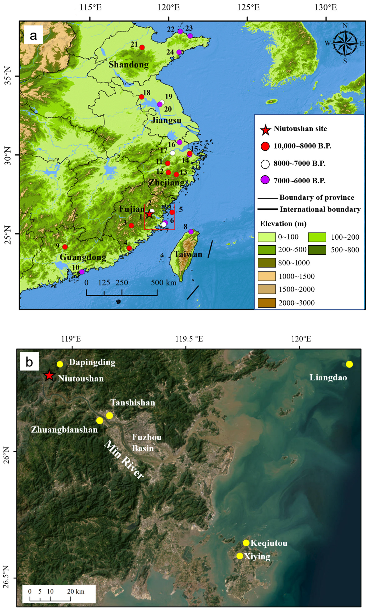
The coastal region of Fujian (Figure 1) holds strategic importance for studying the survival, dispersal, and interaction of prehistoric coastal populations in southeastern China [17,18]. Archaeological research has established a Neolithic cultural sequence in the lower Min River and the Haitan island extending from the Keqiutou culture (6500–5500 cal. a BP) through the lower layer of the Tanshishan culture (5500–5000 cal. a BP) and the Tanshishan culture (6500–5500 cal. a BP) to the Huangguashan culture (5000–4300 cal. a BP) and the Huangtulun culture (4300–3500 cal. a BP) [19]. In the southern coastal areas of Fujian, the main archaeological cultures include the Fuguodun culture (7500–5000 cal. a BP) and the Damaoshan culture (5000–4300 cal. a BP) [19]. In addition, earlier Neolithic human remains have been identified in the coastal region of Fujian, including the Dapingding site (7500 cal. a BP) [20], the Xiying site (7400–6500 cal. a BP) [21], the Liangdao Daowei site (8300–7400 cal. a BP) [22] and the Canglishan site (9100–8700 cal. a BP) [23]. Previous archaeological and chronological studies demonstrate a close link between environmental changes and human activity along the Holocene coastline of Fujian [24,25,26,27]. Moreover, archaeobotanical and paleogenetic evidence indicate that the Fujian coastal zone served as a critical corridor for early human migration and the spread of rice agriculture during the Early to Middle Holocene [28,29,30,31]. Most Early to Middle Neolithic sites in the region have been discovered on offshore islands (Figure 1), including the Liangdao Daowei site, the Xiying site, and the Keqiutou site on Haitan Island [21]. Although the Qihedong site (Phase III, 10,000–7000 BP) [32] is older, it is located further inland. The absence of Early Neolithic archaeological remains limits a comprehensive understanding of prehistoric human migration and cultural interaction along the southeastern coast of China.
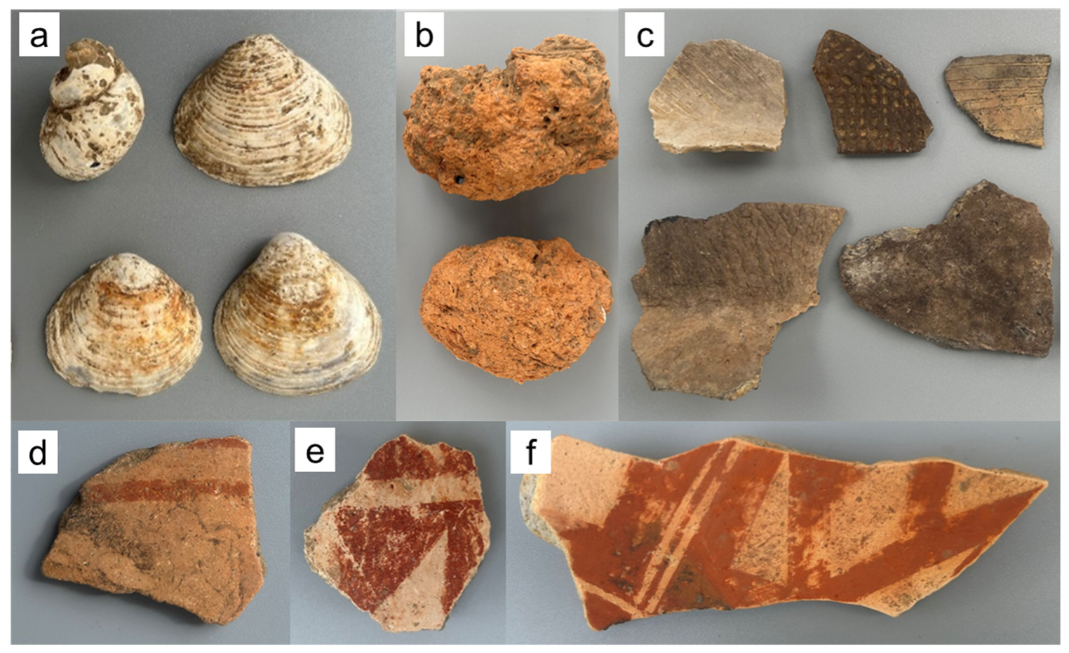
In 2018, the discovery of the Dapingding site dated prehistoric human activities in the lower Min River to 7500 cal. a BP, suggesting that earlier human presence may have extended to the coastal regions beyond the offshore islands. Archaeologists have recently re-examined the Niutoushan site, first discovered in 1979 and located in the lower Min River. This site was initially attributed to the Tanshishan culture (~5000 cal. a BP) [33]. However, among the pottery sherds unearthed from the Neolithic strata of the Niutoushan site, in addition to those with cord marks, stipple marks, and incised decorations (Figure 2c), several pottery sherds with a red slip (Figure 2d–f) were identified recently, indicating that the site could be earlier than previously assumed. To establish a more precise chronology for the Niutoushan site, this study applied both radiocarbon and optically stimulated luminescence (OSL) dating methods to determine the absolute age of its Neolithic remains. Furthermore, we examined the relationship between environmental changes and early human migration in the southeastern coastal region of China.

2. Materials and Methods

2.1. Site Descriptions and Sampling

The Niutoushan (NTS) site (26°16′ N, 118°52′ E; elevation 60 m), located in Xiaoruo Town, Minhou County, lies on the western side of the Fuzhou Basin near the lower reaches of the Min River and covers an area of about 60,000 m2 [34]. In 2023, the Fuzhou Municipal Institute of Archaeology carried out a systematic investigation at the Niutoushan site. The investigation revealed that artefacts such as pottery sherds and stone tools were distributed across the mountain, and the transitional zone from the hilltop to the slope preserved more complete cultural layers.
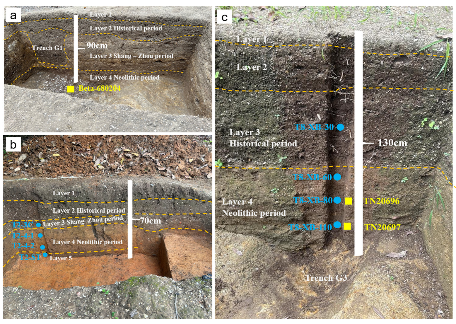
Archaeologists excavated 17 trenches and 15 profiles at the Niutoushan site. However, due to long-term human farming and construction activities, the site has suffered significant anthropogenic disturbance, and well-preserved Neolithic cultural accumulations were found only in some trenches or bottom layers. Therefore, this study selected T2 and T8, which were considered less disturbed, for the systematic collection of OSL samples. In addition, we recovered some charcoal samples (TN20696, TN20697) from the Neolithic layer in T8 and the primary deposits at the bottom of the Neolithic layer in T1 (Beta-680204) (Figure 3). The stratigraphic characteristics of the above three trenches are summarised in Table A1 (Appendix A). Moreover, archaeologists collected samples including charcoal, shells, and animal bones from different trenches and profiles of the site (including T1, T2, T6, T8, T15, and DM4) for radiocarbon dating.

2.2. AMS 14C Dating

Twelve radiocarbon samples—including shells, charcoal, and animal bone—collected from the Neolithic stratum of the Niutoushan site were analysed with Accelerator Mass Spectrometry (AMS) dating at the BETA laboratory (Miami, USA), the accelerator laboratory at Peking University (Beijing, China), and the Guangzhou Institute of Geochemistry, Chinese Academy of Sciences (Guangzhou, China). All conventional ages were calibrated to calendar years using OxCal v4.4 [35] with the IntCal20 calibration curve [36].

2.3. OSL Dating

All the OSL samples were pretreated and measured in the Luminescence Research Laboratory at Linyi University (Linyi, China). Unbleached samples from the central part of the sampling tubes or burnt clay (T8-4HT) were used for equivalent dose (De) determination, while their outer parts were used for dose rate measurements. The samples were treated first with 10% HCl and 30% H2O2 to remove carbonates and organic matter, respectively. The fine-grained fraction (4–11 μm) of T8-4HT was separated by Stokes’ law of settling, and the coarser fractions (90–125 μm, 125–180 μm, 180–250 μm) of the other samples were separated by wet sieving. The fine-grained sample was immersed in H2SiF6 (35%) for 3 days to remove feldspars. For coarse-grained samples, quartz was separated by heavy liquids (sodium polytungstate, 2.62 g/cm3 and 2.75 g/cm3) first and then etched by HF (40%) for 40 min to remove residual feldspars and the alpha-irradiated outer layer of quartz grains. Then all the quartz samples were rinsed with 10% HCl for 40 min to remove fluoride precipitates. Finally, coarse-grained quartz was re-sieved, and magnetic minerals were removed using a magnet. Quartz purity was checked by IR stimulation [37,38]. For the fine-grained sample, large aliquots (9.7 mm) were used, while small aliquots (2 mm) were used for coarse-grained samples. Quartz grains were finally settled onto stainless steel discs using alcohol.
All measurements were conducted on a Risø TL/OSL DA-20 (DTU Nutech, Roskilde, Denmark) system equipped with a 90Y/90Sr beta source. In this study, a modified protocol [38] based on the single-aliquot regenerative-dose protocol (SAR) [39,40] and the standardised growth curve method (SGC) [41] was applied to determine the dose of quartz. A dose recovery test [38] was conducted on 4 aliquots of sample T2-4-1, with a given dose of 21.1 Gy under the preheat temperature of 260 °C (10 s) and cut-heat temperature of 220 °C (10 s). The recovery ratio (measured dose/given dose) of 0.98 ± 0.03 suggests that such a preheating condition is suitable for the quartz samples in this study. In luminescence dating, an Overdispersion (OD) value of ∼20% is widely accepted as the threshold for inferring heterogeneous bleaching. For most samples, the OD values were near or below 20%, indicating a relatively symmetrical De distribution. In these cases, the Central Age Model (CAM) [42] is statistically more robust. When the OD value is well above the 20% threshold, we use the Finite Mixture Model (FMM) [43] to calculate the ages.
Concentrations of U and Th were measured using inductively coupled plasma (ICP) mass spectrometry, and K was measured with ICP optical emission spectrometry. The average water content of all samples was estimated at 20 ± 5% based on the measured values. The environmental dose rate was calculated online using DRAC (v1.2) [44].

3. Results

3.1. Radiocarbon Dating Results

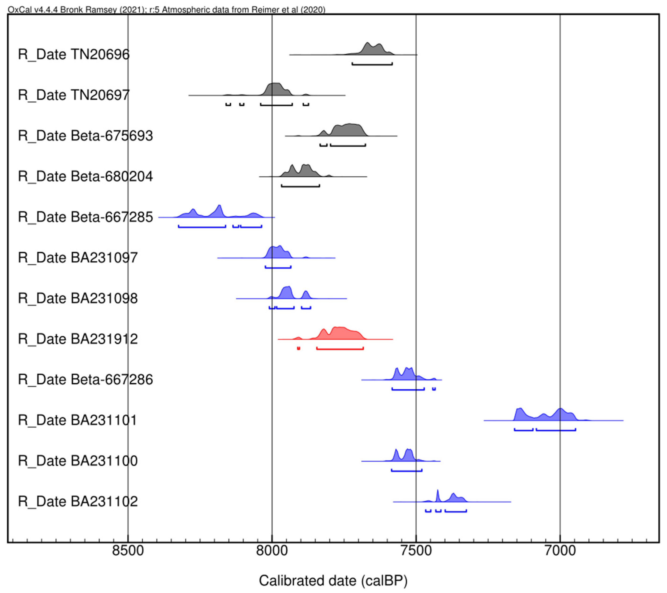
Table 1 and Figure 4 present the 14C dating results from the Neolithic strata of different excavation units at the Niutoushan site. The shell samples exhibit the broadest age range, spanning 8325 to 6946 cal. a BP, whereas the remaining four charcoal samples and one animal bone sample cluster within a narrower interval of 8160 to 7583 cal. a BP.

3.2. OSL Dating Results

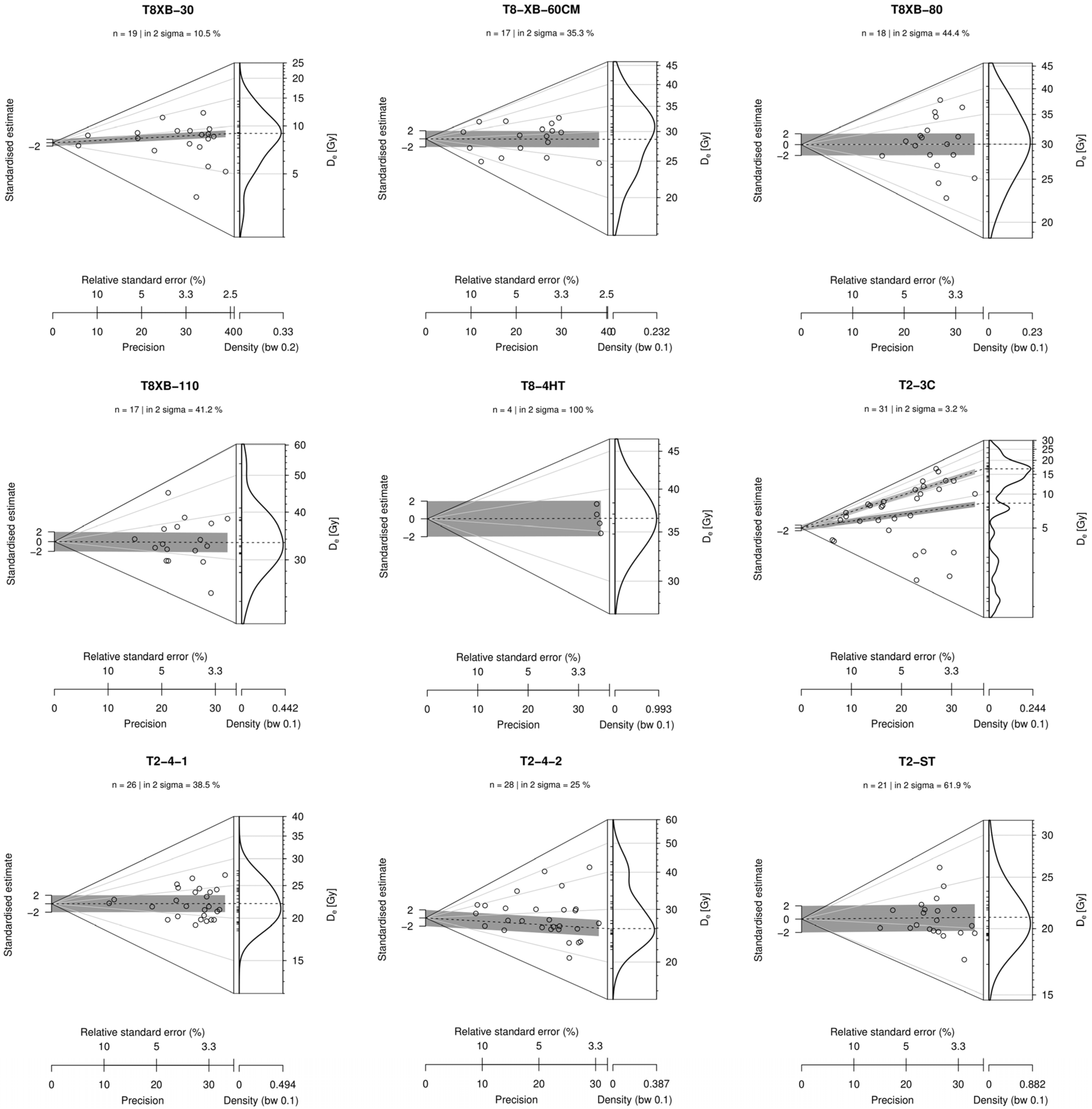
The OSL dating results are shown in Table 2 and Table 3 and Figure A1. The four OSL ages from top to bottom of trench T2 are 7.8 ± 0.6 ka, 10.5 ± 0.5 ka, 11.5 ± 0.5 ka, and 9.0 ± 0.4 ka. A stratigraphic age inversion occurs at the bottom of the trench. Five OSL ages from trench T8 range from 3.8 ± 0.2 ka to 9.3 ± 0.7 ka, aligning with the stratigraphic sequence, where greater sampling depths correspond to older ages. Furthermore, the OSL ages from the Neolithic layer of T8 are generally consistent with the three charcoal radiocarbon dates (8160–7583 cal. a BP) from the same trench.

4. Discussion

4.1. The Chronology of the Niutoushan Site

In radiocarbon dating results, the shell sample Beta-667285 (8325–8037 cal. a BP) yielded an older age than the charcoal and animal bone samples (7967–7684 cal. a BP) from the same excavation unit, whereas the shell sample BA231101 (7158–6946 cal. a BP) produced the youngest age. Meanwhile, shell samples BA231097 (8023–7935 cal. a BP) and BA231098 (8010–7866 cal. a BP) from trench T1 yielded ages comparable to those of charcoal and animal bone from the same trench. Three additional shell samples (Beta-667286, BA231100, BA231102) clustered between 7585 and 7326 cal. a BP.
In the OSL results, the De distribution of T2-3C exhibits high dispersion, indicating multiple dose components (Table 3 and Figure A1). Although the Finite Mixture Model [45,46] was applied to derive a relatively reliable depositional age, the OSL result was 7.8 ± 0.6 ka; however, pottery sherd typology assigned the stratum to the Historic Period rather than the Neolithic. Additionally, T2-4-1 and T2-4-2 yielded ages of 10.5 ± 0.5 ka and 11.5 ± 0.5 ka, respectively, whereas T2-ST (layer 5) at the base, which lacked artefacts, produced an age of 9.0 ± 0.4 ka, indicating stratigraphic inversion. In trench T8, we observed that the OSL ages (T8-XB-80 and T8-XB-110) were older than the radiocarbon dates obtained from the same stratigraphic depth. This discrepancy may be attributed to heterogeneous bleaching of quartz grains and dispersion among multiple aliquot data, resulting in a systematic error between the age derived from the Central Age Model and the actual depositional age. Moreover, the relatively overestimated age of sample T8-XB-110 might be due to the underlying bedrock. Under ideal circumstances, environmental doses were derived from the surrounding soil of the sample. However, sample T8-XB-110 was collected near the bottom of the profile and close to the bedrock. The weathered layer may exhibit a higher environmental dose rate than the soil layer [47], which could result in an underestimation of the measured environmental dose rate and thereby lead to an overestimation of the calculated age relative to the corresponding radiocarbon age. The absence of direct dose-rate measurements for the underlying bedrock introduces some uncertainty. However, considering the sampling distance from the lithological boundary and the typical attenuation of gamma radiation in sediments, the bedrock’s contribution is likely secondary compared to the internal and sedimentary dose rates. Future studies should prioritise in situ gamma spectrometry at such boundaries to further refine the age models.
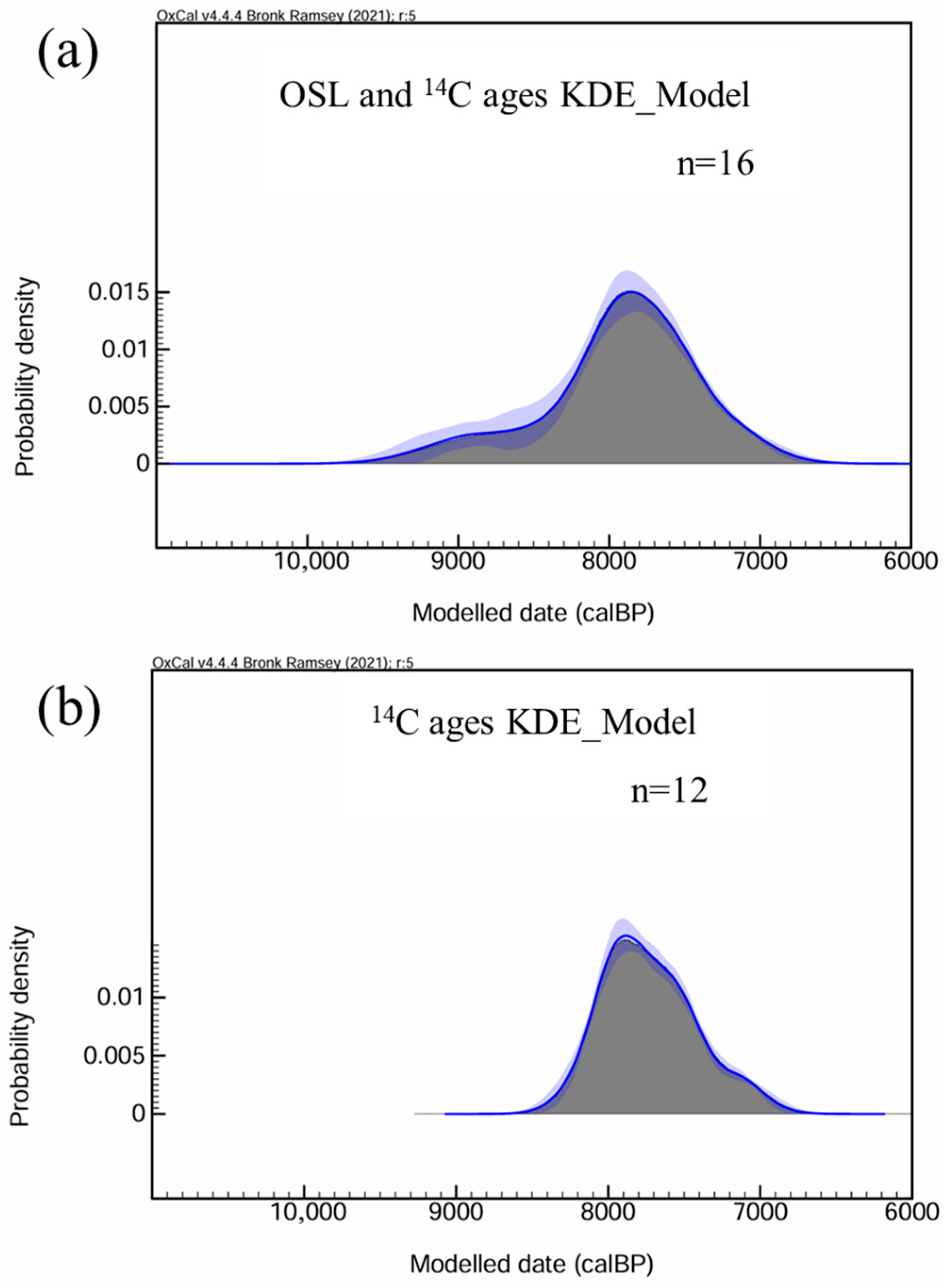
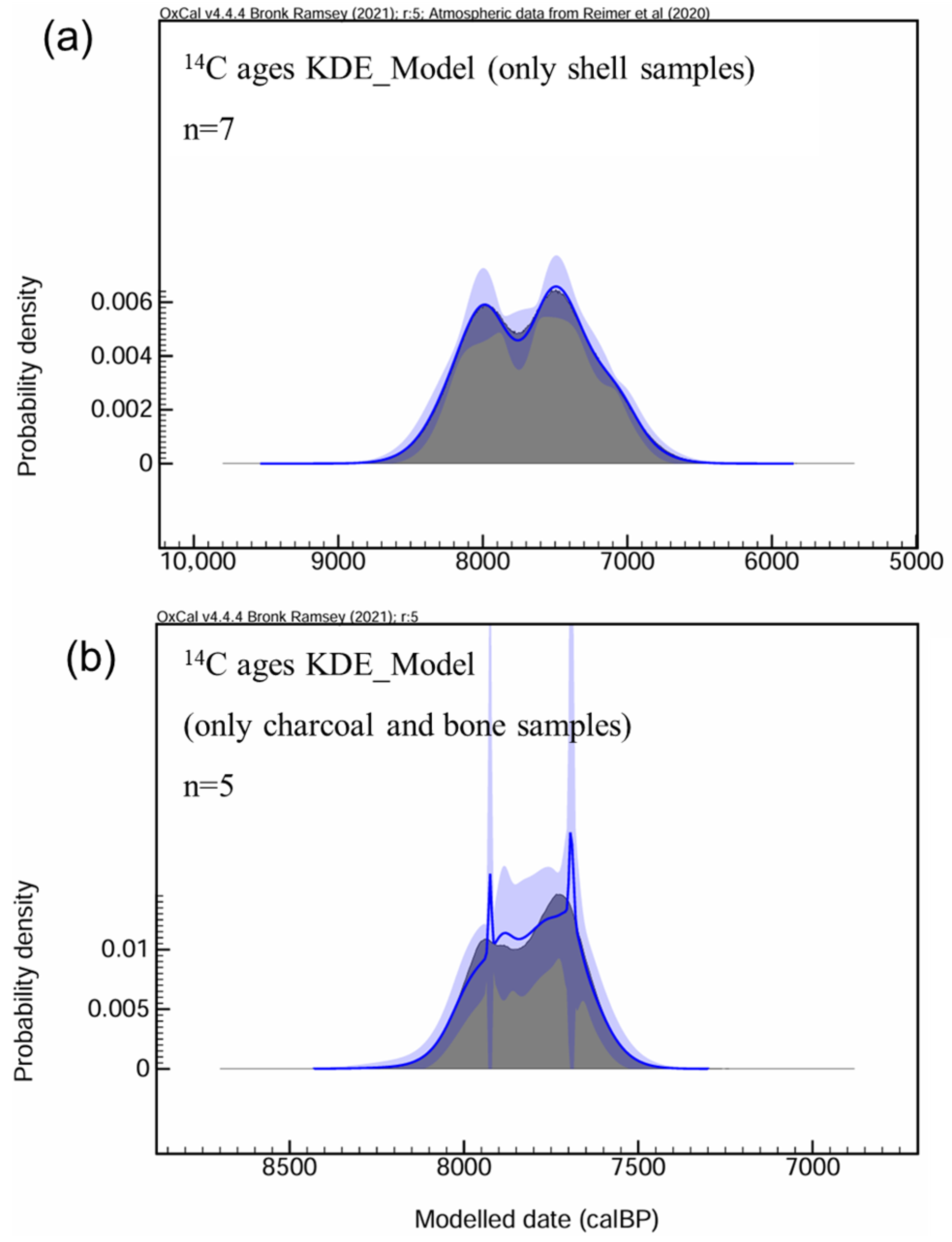
To integrate dating results from multiple materials and methods, we applied kernel density estimation (KDE) in OxCal 4.4 to model both radiocarbon and OSL ages from the Neolithic layer, reducing noise and producing smoother, more realistic probability density distributions [48]. As a byproduct of ancient human collection and consumption of shellfish, shell dating directly reflects the timing of human occupation. However, radiocarbon dating of shells can be influenced by potential reservoir effects in aquatic environments [49,50,51]. By comparing the kernel density distributions of ages from shell samples and other radiocarbon-dated samples (charcoal and bone), it can be observed that their peak ranges are relatively close (Figure 5). Therefore, shell samples were not significantly affected by the reservoir effect. Considering the age inversion observed in T2, the OSL data from this unit were not included in the final KDE model. Additionally, a separate KDE analysis was performed on the 12 radiocarbon dates to assess the influence of the older OSL ages in trench T8 on the overall KDE outcomes.
As shown in Figure 6, the KDE peak derived from the combined dataset of radiocarbon dates of shells, charcoal and animal bone and OSL ages of sediments (quartz particles from soil and burnt clay) is consistent with that generated solely from radiocarbon dates, with both peaking at approximately 8000–7500 cal. a BP. Given the younger age limits of the dating results, we conclude that the main phase of Neolithic human occupation at the Niutoushan site dates to 8000–7000 cal. a BP. This places the Niutoushan site among the earliest Neolithic sites in coastal Fujian.
The term “Neolithic” at Niutoushan represents more than a technical classification; it signifies a transformation in settlement patterns and human-environment interactions [52]. Within this coastal context, it reflects a transition toward increased sedentism and organised resource utilisation, establishing a distinct regional trajectory of Neolithization. The robust chronological framework (8000–7000 cal. a BP), together with a comprehensive conceptual perspective, provides a foundation for reassessing cultural dynamics and human-environment relationships on the Fujian coast during the early Holocene. This approach also facilitates more nuanced comparisons between Niutoushan and other sites, elucidating diverse subsistence strategies and migration patterns among early coastal populations.

4.2. Sea-Level Change and Human Migration in the Coastal Region of Southeast China

Our refined dating results confirm that human occupation at Niutoushan was broadly synchronous with the earliest maritime Neolithic remains found on the Liangdao Islands [22,53]. This synchronicity, however, reveals a significant spatial heterogeneity in subsistence patterns: the former is characterised by the exploitation of terrestrial and freshwater resources, while the latter reflects a specialised utilisation of marine resources. This contrast suggests that as early as 8000 years ago, early Neolithic groups on the South China coast had already developed diversified adaptive strategies to exploit different ecological niches within the coastal-island continuum.
Furthermore, when integrated with recent discoveries from the first phase of the Dapingding site—where rice cultivation was practised around 7500 cal. a BP [20]—a clearer picture of regional cultural complexity emerges. These findings indicate that a diverse range of human groups, utilising both terrestrial and aquatic ecosystems, inhabited the southeastern coast of China. This evidence not only underscores the importance of coastal regions as corridors for human dispersal but also provides a key temporal link for tracing human migration patterns between northern and southern China along the coastline during the early Neolithic transition.
Key questions include the origins of 8000-year-old Neolithic groups, such as those at Niutoushan and Dapingding; the influence of different regional Neolithic cultures on these groups; and how environmental changes from the Last Glacial Maximum (LGM) to the Early Holocene shaped migration and cultural exchange in South China’s coastal region. In the lower reach of Min River, the Dapingding site yielded clear evidence of charred rice remains and rice phytoliths undergoing domestication, along with a small number of red-slip pottery shards from its early phase [20,31]. Scholars infer that the Dapingding site may have been influenced by Early Neolithic cultures from the coastal regions of Zhejiang to the north, especially since rising sea levels around 8000 years ago submerged the Fuzhou Basin, with the coastline extending deep into its western part and forming a coastal corridor from coastal Zhejiang to western Fuzhou Basin [54]. Genetic evidence from the slightly older Liangdao 1 individual suggests connections to ancient northern populations [28]. The Neolithic remains at Niutoushan also include red-slip pottery shards, indicating northern cultural influences during the Early Neolithic period. However, while such pottery shards were relatively rare at Niutoushan, many shards display unique traits distinct from those of contemporary Neolithic cultures in northern coastal regions such as Zhejiang [55]. This suggests that the Neolithic remains at Niutoushan likely derived from more local or alternative sources.
Large-scale ancient DNA evidence from the eastern China coastal region indicates that bidirectional population exchanges along the coastal region began at least 9000 years ago [28]. Consequently, the vast area south of Niutoushan may also have contributed to its cultural development. Qihedong, one of the few cave sites in the mountains of southern China, preserves a relatively complete cultural sequence spanning the transition from the Palaeolithic to the Neolithic age [32]. Although connections between Qihedong and the lower Min River region during the Early to Middle Holocene remain unclear, studies suggest that inland–coastal communication likely occurred through riverine channels [56]. Furthermore, beyond cultural contributions from inland regions, the broad western coast of the Taiwan Strait and the submerged area south of the Niutoushan site may represent additional sources of cultural development.
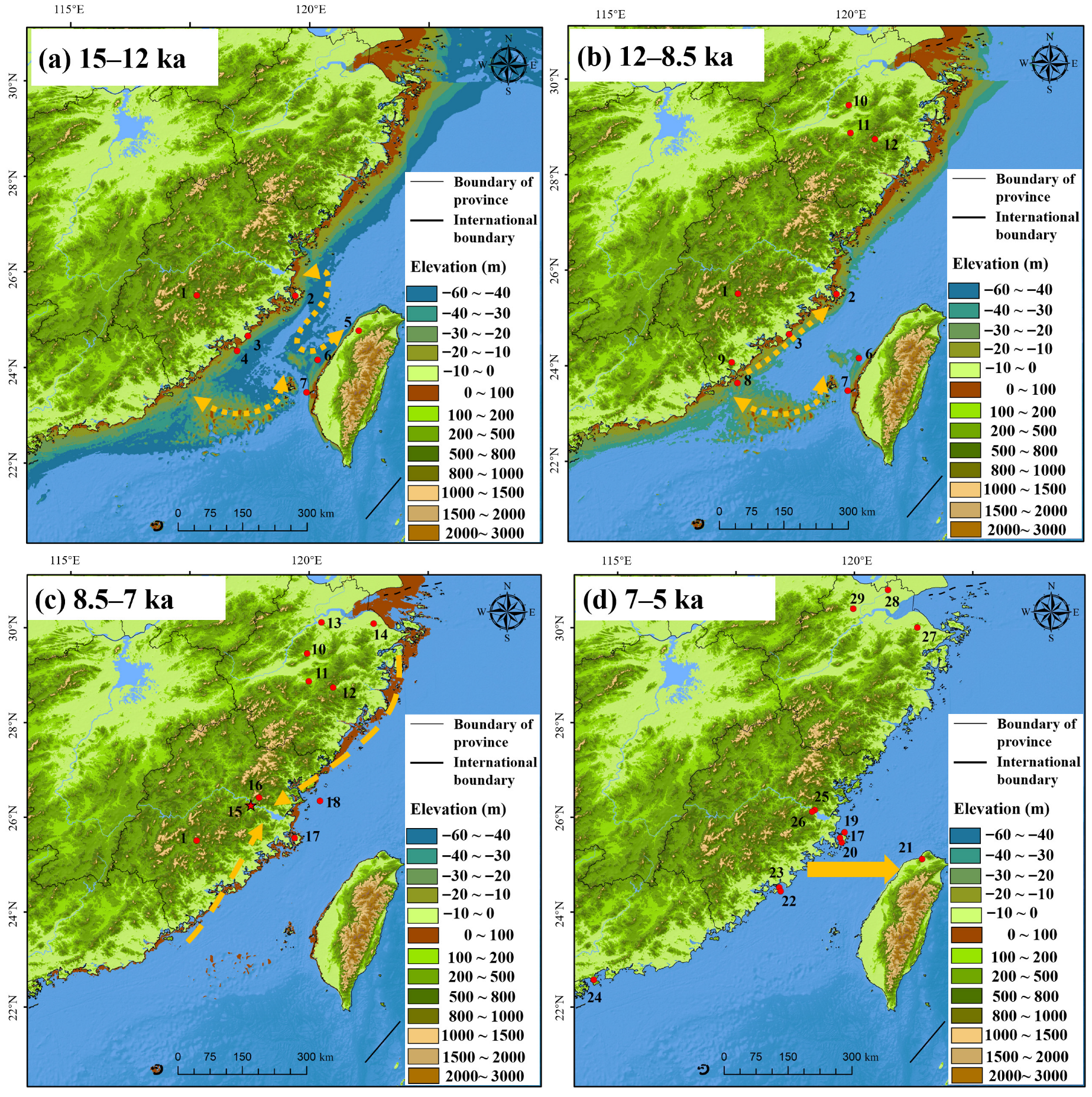
During the LGM, global sea levels were approximately 130 m lower than at present [57], exposing vast sections of the continental shelf along the Chinese coast. At that time, the Taiwan Strait remained unsubmerged. Fossil evidence from the region—including the Penghu 1 mandible, Haixia man, and the Penghu fauna—suggests that ancient humans likely inhabited the continental shelf between Fujian and Taiwan during the Late Pleistocene [58,59,60] (Figure 7a). Around 10,000 years ago, sea levels stood approximately 37 m below present levels [61], leaving much of the southern Taiwan Strait exposed and providing potentially habitable environments for human populations. However, rapid sea-level rise during the Holocene eventually submerged this land bridge, displacing human groups toward adjacent mainland and island coasts (Figure 7b,c). Collectively, the above environmental and archaeological evidence supports the hypothesis that Early Neolithic coastal communities—such as those at Canglishan, Liangdao, and Niutoushan—may have originated from Palaeolithic groups once occupying the western coastal regions of the Taiwan Strait and the exposed continental shelf, which were later submerged during the LGM and deglacial period.
After 7 ka, the rate of sea-level rise slowed, and relative sea levels approached present-day heights [61]. Although sea-level fluctuations continued thereafter [63,64], a more stable geomorphic environment combined with abundant food resources encouraged ancient populations to settle increasingly close to the coast and adopt subsistence strategies centred on marine exploitation. This transition led to a marked increase in coastal sites from eastern to southern China between 7 ka and 5 ka (Figure 7d). By around 5000 cal. a BP, flourishing coastal civilisations had developed long-distance navigation capacities [24], and crops—including rice and millet—were transported across the Taiwan Strait to Taiwan Island [65,66,67], thereby contributing to the emergence and development of agriculture in Taiwan.
The evidence presented here suggests that the Niutoushan culture was influenced by Neolithic cultures from the northern coastal regions and, potentially, by those to the south across the exposed Taiwan Strait during the LGM to the Early Holocene. Genetic and archaeological data from sites such as Qihedong, Liangdao, and Dapingding, combined with environmental evidence on sea-level change, suggest complex interactions among early Neolithic cultures in both northern and southern coastal China. These findings highlight the need for further research to clarify the extent and mechanisms of these interactions, offering deeper insights into migration patterns and cultural exchanges during the early Neolithic period in southeastern China.

5. Conclusions

In this study, we applied radiocarbon and OSL dating to multiple samples from the Niutoushan shell mound site in the lower Min River region. The results suggest that the Neolithic occupation of this site occurred primarily between 8000 and 7000 cal. a BP. This evidence positions Niutoushan as one of the earliest known Neolithic sites in both the lower Min River region and along China’s southeastern coast. These findings indicate that Neolithic populations were already significantly distributed across the eastern Chinese coastline around 8000 years ago. This presents an exciting opportunity for future archaeological research focused on the early Neolithic period along the southeastern coast of China, which could yield important insights into the origins and development of Chinese oceanic cultures. Additionally, it may help illuminate the interactions between mainland and oceanic cultures in China, fostering a deeper understanding of their historical dynamics.

Author Contributions

Conceptualisation, X.Z.; methodology, Z.H. and X.Z.; software, Z.H.; formal analysis, Z.H., X.Z., L.Y. and C.W.; investigation, X.Z., J.J., Y.L., L.R., H.X., G.Z., Y.H. and Y.Z.; resources, H.D., F.L. and X.Z. data curation, Z.H., X.Z., H.D., F.L., L.Y. and C.W.; writing—original draft preparation, Z.H. and L.Y. (OSL chronology); writing—review and editing, X.Z.; visualisation, Z.H.; supervision, X.Z. and Y.G.; project administration, X.Z.; funding acquisition, X.Z. All authors have read and agreed to the published version of the manuscript.

Funding

This research was jointly supported by the Natural Science Foundation of China (42477478), the Fujian Provincial Natural Science Foundation (2023R1041, 2025J010029, and 2024J02012), the Archaeological Talent Promotion Program of China (2025-183) and the Project of Taishan Scholars (tsqn202408266).

Data Availability Statement

The datasets generated during and/or analysed during the current study are available from the corresponding author on reasonable request.

Acknowledgments

We thank the editors and anonymous reviewers for their constructive assessments that helped to improve the manuscript. During the preparation of this work, the authors used ChatGPT 5.2 (developed by OpenAI) to enhance the language. After using this tool, the authors reviewed and edited the content as needed and take full responsibility for the content of the publication.

Conflicts of Interest

The authors declare that they have no known competing financial interests or personal relationships that could have appeared to influence the work reported in this paper.

Appendix A

Table A1. Summary of Archaeological Trench Stratigraphic Information.
TrenchLayer
(Depth Interval)
ArtefactsCultural Period & Context
T1Layer 1
(0–10 cm)
Fragmented shellsModern cultivated layer
Layer 2
(10–25 cm)
Fragmented shells, sand-tempered pottery shards, hard pottery shards, and a few ceramic shardsHistorical period layer
Layer 3
(25–75 cm)
Shells, sand-tempered pottery shards, and hard pottery shardsShang-Zhou period layer
Layer 4
(75–100 cm)
Shells, polished grey sand-tempered shards, sand-tempered pottery shards with red slip, animal bones, and burned clayNeolithic layer
Bedrock
(>100 cm)
No artefacts/
T2Layer 1
(0–10 cm)
Fragmented shellsModern cultivated layer
Layer 2
(10–30 cm)
Fragmented shells, sand-tempered pottery shards, orange-yellow pottery shards, hard pottery shards, burned clay, and animal bonesHistorical period layer
Layer 3
(30–40 cm)
Shells, sand-tempered pottery shards, orange-yellow pottery shards, hard pottery shards, burned clay, and animal bonesShang–Zhou period layer
Layer 4
(40–65 cm)
Sand-tempered pottery shardsNeolithic layer
Layer 5
(65–70 cm)
No artefacts/
T8Layer 1
(0–5 cm)
Fragmented shells, sand-tempered pottery shardsModern cultivated layer
Layer 2
(5–20 cm)
Fragmented shells, sand-tempered pottery shards, and bonesHistorical period layer
Layer 3
(20–55 cm)
Fragmented shells, sand-tempered pottery shards, coloured pottery shards, ceramic shards, burned clay, a few brackish water shells, and animal bonesHistorical period layer
Layer 4
(55–130 cm)
Shell tools, coloured pottery shards, sand-tempered pottery shards, and bonesNeolithic layer
Layer 4 G3
(55–130 cm)
Sand-tempered pottery shards, coloured pottery shards, burned clay, and animal bonesNeolithic layer
Figure A1. The distributions of De values for OSL samples.
Quaternary 09 00036 g0a1
Table A2. Ages of the sites shown in Figure 6.
SiteDate (ka)Reference
Qihedong17–7[32]
Kuahaicun25–10[61]
Shenhu bay15–10[19]
Haixia man~20[58]
Qianyuan cave~15[58]
Penghu fauna25–10[58]
Penghu 1 mandible70–10 or 130–190[60]
Dongshan man~10[58]
Canglishan9.1–8.7[23]
Shangshan10–8.5[68]
Huxi9–8.4[69]
Xiatang9.3–8.3[70]
Kuahuqiao8–7[71]
Jingtoushan8.3–7.8[72]
Dapingding7.5[20]
Liangdao8.3–7.4[22]
Xiying7.4–6.5[21]
Keqiutou6.5–5.5[19]
Citanghou6.8–6.5[30]
Tapenkeng7–5[58]
Fuguodun7.5–5[73]
Jinguishan7.8–5.6[73]
Xiantouling7–5[73]
Tanshishan5–4.3[19]
Zhuangbianshan5–4.3[19]
Hemudu7–5.3[71]
Majiabang7–6[71]
Liangzhu5.3–4.3[71]

References

  1. Bailey, G. World prehistory from the margins: The role of coastlines in human evolution. J. Interdiscip. Stud. Hist. Archaeol. 2004, 1, 39–50. [Google Scholar]
  2. Erlandson, J.M.; Fitzpatrick, S.M. Oceans, Islands, and Coasts: Current Perspectives on the Role of the Sea in Human Prehistory. J. Isl. Coast. Archaeol. 2006, 1, 5–32. [Google Scholar] [CrossRef]
  3. Williams, A.N.; Ulm, S.; Sapienza, T.; Lewis, S.; Turney, C.S.M. Sea-level change and demography during the last glacial termination and early Holocene across the Australian continent. Quat. Sci. Rev. 2018, 182, 144–154. [Google Scholar] [CrossRef]
  4. Zheng, Z.; Ma, T.; Tang, Y.; Barry, V.R.; Zong, Y.; Huang, K.; Wan, Q.; Chen, C.; Zhang, X.; Chen, B.; et al. Holocene environmental changes and prehistoric agricultural development along the coastal areas of south China to southeast Asia. Chin. Sci. Bull. 2024, 69, 2553–2567. [Google Scholar] [CrossRef]
  5. Guedes, J.D.; Austermann, J.; Mitrovica, J.X. Lost Foraging Opportunities for East Asian Hunter-Gatherers Due to Rising Sea Level Since the Last Glacial Maximum. Geoarchaeology 2016, 31, 255–266. [Google Scholar] [CrossRef]
  6. Zheng, H.; Zhou, Y.; Yang, Q.; Hu, Z.; Ling, G.; Zhang, J.; Gu, C.; Wang, Y.; Cao, Y.; Huang, X.; et al. Spatial and temporal distribution of Neolithic sites in coastal China: Sea level changes, geomorphic evolution and human adaption. Sci. China Earth Sci. 2017, 61, 123–133. [Google Scholar] [CrossRef]
  7. Coles, B.J. Doggerland: A speculative survey. Proc. Prehist. Soc. 1998, 64, 45–81. [Google Scholar] [CrossRef]
  8. Gaffney, V.; Fitch, S.; Smith, D. Europe’s Lost World; Council for British Archaeology: York, UK, 2009. [Google Scholar] [CrossRef]
  9. Allaby, R.G.; Ware, R.; Cribdon, R.; Hansford, T.A.; Kinnaird, T.; Hamilton, D.; Kistler, L.; Murgatroyd, P.; Bates, R.; Fitch, S.; et al. Early Colonization before Inundation Consistent with Northern Glacial Refugia in Southern Doggerland Revealed by Sedimentary Ancient DNA. Proc. Natl. Acad. Sci. USA 2026, 123, e2508402123. [Google Scholar] [CrossRef] [PubMed]
  10. Berghuis, H.W.K.; Kaifu, Y.; Wibowo, U.P.; van Kolfschoten, T.; Sutisna, I.; Noerwidi, S.; Adhityatama, S.; van den Bergh, G.; Pop, E.; Suriyanto, R.A.; et al. The Late Middle Pleistocene Homo Erectus of the Madura Strait, First Hominin Fossils from Submerged Sundaland. Quat. Environ. Hum. 2025, 3, 100068. [Google Scholar] [CrossRef]
  11. Zeanah, D.W.; Veth, P.M.; Basgall, M.E.; Glover, D.; Bradshaw, R.; Ditchfield, K.; Hook, F.; Seah, I. Barrow Island Lithic Scatters: A Unique Record of Occupation Patterns on the North West Shelf before Insularisation. Quat. Sci. Rev. 2024, 329, 108547. [Google Scholar] [CrossRef]
  12. Hardy, K.; Barlow, N.L.M.; Taylor, E.; Bradley, S.L.; McCarthy, J.; Rush, G. At the Far End of Everything: A Likely Ahrensburgian Presence in the Far North of the Isle of Skye, Scotland. J. Quat. Sci. 2025, 40, 847–861. [Google Scholar] [CrossRef]
  13. Marwick, B.; Van Vlack, H.G.; Conrad, C.; Shoocongdej, R.; Thongcharoenchaikit, C.; Kwak, S. Adaptations to Sea Level Change and Transitions to Agriculture at Khao Toh Chong Rockshelter, Peninsular Thailand. J. Archaeol. Sci. 2017, 77, 94–108. [Google Scholar] [CrossRef]
  14. Erlandson, J.M.; Graham, M.H.; Bourque, B.J.; Corbett, D.; Estes, J.A.; Steneck, R.S. The kelp highway hypothesis: Marine ecology, the coastal migration theory, and the peopling of the Americas. J. Isl. Coast. Archaeol. 2007, 2, 161–174. [Google Scholar] [CrossRef]
  15. Hale, J.C.; Benjamin, J.; Woo, K.; Astrup, P.M.; McCarthy, J.; Hale, N.; Stankiewicz, F.; Wiseman, C.; Skriver, C.; Garrison, E.; et al. Submerged Landscapes, Marine Transgression and Underwater Shell Middens: Comparative Analysis of Site Formation and Taphonomy in Europe and North America. Quat. Sci. Rev. 2021, 258, 106867. [Google Scholar] [CrossRef]
  16. He, K.; Lyu, H. Sea level changes and human activities along the eastern coastal zone of China over the past 20,000 years—With a short comment by ZHAO Xitao. Prehist. Archaeol. 2025, 2, 43–59. (In Chinese) [Google Scholar] [CrossRef]
  17. Chang, K.C.; Goodenough, W.H. Archaeology of southeastern coastal China and its bearing on the Austronesian homeland. Trans. Am. Philos. Soc. 1996, 86, 36–56. [Google Scholar] [CrossRef] [PubMed]
  18. Jiao, T. Archaeology of Southeast China and the Search for an Austronesian Homeland. Soc. Sci. China 2021, 42, 161–170. [Google Scholar] [CrossRef]
  19. Jiao, T.; Fan, X. Fujian and Austronesian; Science Press: Beijing, China, 2020. (In Chinese) [Google Scholar]
  20. Wu, W. New thinking on the transmission route of rice agriculture in Southeast Coast of China during Neolithic age. Agric. Archaeol. 2018, 4, 62–65. (In Chinese) [Google Scholar]
  21. Zhou, Z.; Zhang, W.; Wei, C.; Chen, S.; Fan, X.; Han, W.; Wang, X. Keqiutou Neolithic Site Group in Pingtan Comprehensive Experimental Zone, Fujian Province. Archaeology 2024, 7, 3–23. (In Chinese) [Google Scholar]
  22. Chen, C.Y.; Chiu, H.L. Excavation of Liangdao-Daowei Sites Group, Liangdao, Matsu Archipalego and the Treatments of “Liangdao Man” of the Liangdao-Daowei-I Site; Culture Bureau Liangjian County: Fuzhou, China, 2013. [Google Scholar]
  23. Lyu, J.; Wei, C.; Pan, G.; Huang, Y.; Zhang, W.; Fu, L.; Wang, X.; Huang, H.; Lou, J.; Gan, C.; et al. 2024 Annual Summary of Fujian Archaeological Achievements. Fujian Wenbo 2025, 1, 8–16. (In Chinese) [Google Scholar]
  24. Rolett, B.V.; Zheng, Z.; Yue, Y. Holocene sea-level change and the emergence of Neolithic seafaring in the Fuzhou Basin (Fujian, China). Quat. Sci. Rev. 2011, 30, 788–797. [Google Scholar] [CrossRef]
  25. Ma, T.; Zheng, Z.; Rolett, B.V.; Lin, G.; Zhang, G.; Yue, Y. New evidence for Neolithic rice cultivation and Holocene environmental change in the Fuzhou Basin, southeast China. Veg. Hist. Archaeobotany 2016, 25, 375–386. [Google Scholar] [CrossRef]
  26. Jin, J.; Li, F.; Zuo, X.; Huang, Y.; Ling, Z.; Li, Z. OSL dating of Zhuangbianshan site in the humid subtropical coastal region of China. Boreas 2021, 51, 149–158. [Google Scholar] [CrossRef]
  27. Qiu, J.; Jin, J.; Wang, X.; Wei, C.; Zuo, X.; Wei, J. OSL chronological evidence reveals one of the earliest island-type Neolithic sites in the coastal area of South China. Holocene 2022, 33, 27–37. [Google Scholar] [CrossRef]
  28. Yang, M.A.; Fan, X.; Sun, B.; Chen, C.; Lang, J.; Ko, Y.C.; Tsang, C.H.; Chiu, H.; Wang, T.; Bao, Q.; et al. Ancient DNA indicates human population shifts and admixture in northern and southern China. Science 2020, 369, 282–288. [Google Scholar] [CrossRef] [PubMed]
  29. Ko, A.M.; Tu, H.P.; Ko, Y.C. Genetic insights into the origin, admixture, and migration of the early Austronesian peoples. J. Hum. Genet. 2025, 71, 63–72. [Google Scholar] [CrossRef] [PubMed]
  30. Zhou, G.; Zuo, X.; Zhou, Z.; Jin, J.; Fan, X.; Wei, J.; Pei, Y.; Xie, H.; Huang, Y.; Ren, L.; et al. Early Island rice farmers on the South China Coast during the 7th millennium BP. J. Archaeol. Sci. 2025, 175, 106158. [Google Scholar] [CrossRef]
  31. Zuo, X.; Dai, J.; Wu, W.; Jin, J.; Ge, W.; Wang, Y.; Ren, L.; Lin, Y.; Pei, Y.; Xie, H. Microfossil evidence of rice cultivation on the Southeast China Coast 7500 years ago. Sci. China Earth Sci. 2022, 65, 2115–2126. [Google Scholar] [CrossRef]
  32. Fan, X.; Huang, Y.; Wei, C.; Lu, J.; Wang, Y. Brief report of the Qihedong site, Zhangping City, Fujian Province. Archaeology 2013, 5, 7–19. (In Chinese) [Google Scholar]
  33. Zhang, Q. A ancient cultural site was discovered in Xiaoruo Village, Minhou County. Fujian Wenbo 1980, 1, 36. (In Chinese) [Google Scholar]
  34. Zhang, Y.; Zhao, R.; Zhao, X.; Li, F.; Cai, X.; Liang, R.; Lin, F. Survey Brief on the Site Group in Xiaoruo Village, Minhou County, Fuzhou City. Fujian Wenbo 2015, 2, 50–55. (In Chinese) [Google Scholar]
  35. Bronk Ramsey, C. Bayesian Analysis of Radiocarbon Dates. Radiocarbon 2009, 51, 337–360. [Google Scholar] [CrossRef]
  36. Reimer, P.J.; Austin, W.E.N.; Bard, E.; Bayliss, A.; Blackwell, P.G.; Bronk Ramsey, C.; Butzin, M.; Cheng, H.; Edwards, R.L.; Friedrich, M.; et al. The IntCal20 Northern Hemisphere Radiocarbon Age Calibration Curve (0–55 cal kBP). Radiocarbon 2020, 62, 725–757. [Google Scholar] [CrossRef]
  37. Duller, G.A.T. Distinguishing quartz and feldspar in single grain luminescence measurements. Radiat. Meas. 2003, 37, 161–165. [Google Scholar] [CrossRef]
  38. An, P.; Yu, L.; Wang, Y.; Miao, X.; Wang, C.; Lai, Z.; Shen, H. Holocene incisions and flood activities of the Keriya River, NW margin of the Tibetan plateau. J. Asian Earth Sci. 2020, 191, 104224. [Google Scholar] [CrossRef]
  39. Murray, A.S.; Wintle, A.G. Luminescence dating of quartz using an improved single-aliquot regenerative-dose protocol. Radiat. Meas. 2000, 32, 57–73. [Google Scholar] [CrossRef]
  40. Murray, A.S.; Wintle, A.G. The single aliquot regenerative dose protocol: Potential for improvements in reliability. Radiat. Meas. 2003, 37, 377–381. [Google Scholar] [CrossRef]
  41. Roberts, H.M.; Duller, G.A.T. Standardised growth curves for optical dating of sediment using multiple-grain aliquots. Radiat. Meas. 2004, 38, 241–252. [Google Scholar] [CrossRef]
  42. Galbraith, R.F.; Roberts, R.G.; Laslett, G.M.; Yoshida, H.; Olley, J.M. Optical dating of single and multiple grains of quartz from Jinmium Rock Shelter, northern Australia: Part I, experimental design and statistical models. Archaeometry 1999, 41, 339–364. [Google Scholar] [CrossRef]
  43. Burow, C. calc_FiniteMixture(): Apply the finite mixture model (FMM) after Galbraith (2005) to a given De distribution; Function version 0.4.2. In Luminescence: Comprehensive Luminescence Dating Data Analysis; Kreutzer, S., Burow, C., Dietze, M., Fuchs, M.C., Schmidt, C., Fischer, M., Friedrich, J., Mercier, N., Philippe, A., Riedesel, S., et al., Eds.; R Package Version 0.9.23; CRAN: Vienna, Austria, 2023; Available online: https://CRAN.R-project.org/package=Luminescence (accessed on 21 February 2025).
  44. Durcan, J.A.; King, G.E.; Duller, G.A.T. DRAC: Dose Rate and Age Calculator for trapped charge dating. Quat. Geochronol. 2015, 28, 54–61. [Google Scholar] [CrossRef]
  45. Peng, J.; Li, B.; Jacobs, Z.; Gliganic, L.A. Optical dating of sediments affected by post-depositional mixing: Modelling, synthesizing and implications. Catena 2023, 232, 107383. [Google Scholar] [CrossRef]
  46. Roberts, R.G.; Galbraith, R.F.; Yoshida, H.G.; Laslett, M.; Olley, J.M. Distinguishing dose populations in sediment mixtures: A test of single-grain optical dating procedures using mixtures of laboratory-dosed quartz. Radiat. Meas. 2000, 32, 459–465. [Google Scholar] [CrossRef]
  47. Wang, C.; Huang, C.; Fan, A.; Li, S. The De underestimation caused by the unstable medium component in the initial OSL signal from lava-baked quartz and correction strategies. Quat. Geochronol. 2024, 82, 101532. [Google Scholar] [CrossRef]
  48. Ramsey, C.B. Methods for Summarizing Radiocarbon Datasets. Radiocarbon 2017, 59, 1809–1833. [Google Scholar] [CrossRef]
  49. Reimer, P.J. Marine or estuarine radiocarbon reservoir corrections for mollusks? A case study from a medieval site in the south of England. J. Archaeol. Sci. 2014, 49, 142–146. [Google Scholar] [CrossRef]
  50. Rech, J.A.; Tenison, C.N.; Baldasare, A.; Currie, B.S. Radiocarbon Dating and Freshwater Reservoir Effects of Aquatic Mollusks within Fluvial Channel Deposits in the Midwestern United States. Radiocarbon 2023, 65, 1098–1117. [Google Scholar] [CrossRef]
  51. Zhang, Y.; Qin, F.; Pu, X.; Wei, W.; Piper, P.J. Chronological analysis of prehistoric freshwater shell mounds in the Yongjiang River Basin, Guangxi, China. Archaeol. Res. Asia 2024, 37, 100502. [Google Scholar] [CrossRef]
  52. Nowak, M. Do We Finally Know What the Neolithic Is? Open Archaeol. 2022, 8, 332–342. [Google Scholar] [CrossRef]
  53. Ko, A.M.S.; Chen, C.Y.; Fu, Q.; Delfin, F.; Li, M.; Chiu, H.L.; Stoneking, M.; Ko, Y.C. Early Austronesians: Into and out of Taiwan. Am. J. Hum. Genet. 2014, 94, 426–436. [Google Scholar] [CrossRef] [PubMed]
  54. Lin, Y.; Zuo, X.; Fu, L.; Huang, Y.; Yang, J.; Liu, W.; Zhang, S.; Dai, J.; Xie, H.; Ren, L.; et al. Phytolith evidence of agricultural emergence and its dispersal routes in the southeastern mountain area of China. J. Archaeol. Sci. Rep. 2025, 61, 104975. [Google Scholar] [CrossRef]
  55. Jiang, L. Three types and two stages of the Neolithic age in early China—Discussion on the status of Shangshan culture in the origin of rice farming. Cult. Relics South China 2016, 3, 71–78. (In Chinese) [Google Scholar]
  56. Yang, X.; Chen, Q.; Ma, Y.; Li, Z.; Hung, H.C.; Zhang, Q.; Jin, Z.; Liu, S.; Zhou, Z.; Fu, X. New radiocarbon and archaeobotanical evidence reveal the timing and route of southward dispersal of rice farming in south China. Sci. Bull. 2018, 63, 1495–1501. [Google Scholar] [CrossRef]
  57. Lambeck, K.; Rouby, H.; Purcell, A.; Sun, Y.; Sambridge, M. Sea level and global ice volumes from the Last Glacial Maximum to the Holocene. Proc. Natl. Acad. Sci. USA 2014, 111, 15296–15303. [Google Scholar] [CrossRef]
  58. Zhang, S.; Zhang, K. A new insight into the origins of the Austronesian by the paleoenvironmental changes in the Taiwan Strait. Acta Anthropol. Sin. 2024, 43, 797. (In Chinese) [Google Scholar] [CrossRef]
  59. Chang, C.H.; Kaifu, Y.; Takai, M.; Kono, R.T.; Grun, R.; Matsu’ura, S.; Kinsley, L.; Lin, L.K. The first archaic Homo from Taiwan. Nat. Commun. 2015, 6, 6037. [Google Scholar] [CrossRef] [PubMed]
  60. Tsutaya, T.; Sawafuji, R.; Taurozzi, A.J.; Fagernäs, Z.; Patramanis, I.; Troché, M.; Mackie, G.; Gakuhari, T.; Oota, H.; Tsai, C.H.; et al. A male Denisovan mandible from Pleistocene Taiwan. Science 2025, 388, 176–180. [Google Scholar] [CrossRef] [PubMed]
  61. Yu, F.; Li, N.; Tian, G.; Huang, Z.; Xiong, H.; Li, T.; Liu, S.; Liu, Y. A re-evaluation of Holocene relative sea-level change along the Fujian coast, southeastern China. Palaeogeogr. Palaeoclimatol. Palaeoecol. 2023, 622, 111577. [Google Scholar] [CrossRef]
  62. Jin, J.; Wei, J.; Ling, Z.; Hou, C.; Xu, D.; Li, Z. Optically dating of a Paleolithic site in coastal regions of South China and its correlation with the late Pleistocene environment evolution. J. Archaeol. Sci. Rep. 2025, 61, 104887. [Google Scholar] [CrossRef]
  63. Ma, M.; Liu, X.; Zhou, G.; Liu, G.; Che, B. A review of Late Quaternary transgression studies and some basic questions in Fujian coastal area. J. Subtrop. Resour. Environ. 2016, 11, 9–19. (In Chinese) [Google Scholar]
  64. Wang, L.; Wang, Z.; Li, C. Holocene relative sea-level change of Fujian coast, southeastern China: Geological records and comparison with glacio-hydro isostatic adjustment modelling. Haiyang Xuebao 2022, 44, 109–123. (In Chinese) [Google Scholar]
  65. Tsang, C.H.; Li, K.T.; Hsu, T.F.; Tsai, Y.C.; Fang, P.H.; Hsing, Y.I.C. Broomcorn and foxtail millet were cultivated in Taiwan about 5000 years ago. Bot. Stud. 2017, 58, 3. [Google Scholar] [CrossRef]
  66. Dai, J.; Cai, X.; Jin, J.; Ge, W.; Huang, Y.; Wu, W.; Xia, T.; Li, F.; Zuo, X. Earliest arrival of millet in the South China coast dating back to 5500 years ago. J. Archaeol. Sci. 2021, 129, 105356. [Google Scholar] [CrossRef]
  67. Deng, Z.; Kuo, S.C.; Carson, M.T.; Hung, H.C. Early Austronesians Cultivated Rice and Millet Together: Tracing Taiwan’s First Neolithic Crops. Front. Plant Sci. 2022, 13, 962073. [Google Scholar] [CrossRef]
  68. Jiang, L. A Brief Excavation Report of the Shangshan Site in Pujiang County, Zhejiang Province. Archaeology 2007, 9, 7–18. (In Chinese) [Google Scholar]
  69. Jiang, L. The early Neolithic age of the Qiantangjiang Basin and its cultural lineage. Southeast Cult. 2013, 6, 44–53. (In Chinese) [Google Scholar]
  70. Zhong, Z.; Yao, J.; Wang, Q.; Guo, H.; Liu, J. Shangshan cultural remains at the Xiatang site in Xianju County, Zhejiang Province. Archaeology 2025, 7, 17–35. (In Chinese) [Google Scholar]
  71. Jiang, L. Outline of the Prehistoric Civilization History of the Qiantang River. Cult. Relics South. China 2012, 2, 86–97. (In Chinese) [Google Scholar]
  72. Sun, G.; Mei, S.; Lu, X.; Wang, Y.; Wang, Y.; Huang, W. Brief report on the excavation of the Neolithic Site at Jingtoushan in Yuyao City, Zhejiang. Archaeology 2021, 7, 3–26. (In Chinese) [Google Scholar]
  73. Zhang, C.; Hung, X. Early marine cultures on the China Coast. Cult. Relics South. China 2016, 3, 1–13. (In Chinese) [Google Scholar]
Figure 1. (a) main Early to Middle Neolithic archaeological sites along the Eastern China Coast. 1. Niutoushan; 2. Dapingding; 3. Qihedong 4. Canglishan; 5. Liangdao; 6. Keqiutou; 7. Xiying; 8. Tapenkeng; 9. Niulandong; 10. Xiantouling; 11. Shangshan; 12. Huxi; 13. Xiatang; 14. Hemudu; 15. Jingtoushan; 16. Majiabang 17. Kuahuqiao; 18. Shunshanji; 19. Caoyangang; 20. Longqiuzhuang; 21. Houli; 22. Beizhuang; 23. Baishicun; 24. Beiqian. (b) Location of the Niutoushan site and other main sites in the lower Min River.
Quaternary 09 00036 g001
Figure 2. Neolithic remains excavated from the Niutoushan site. (a) Freshwater shells; (b) burnt clay; (c) pottery shards with incised marks, impressed dots, and cord marks; (df) pottery shards with red slip.
Quaternary 09 00036 g002
Figure 3. The sampling profiles. (a) North section of trench T1; (b) south section of trench T2; (c) west section of trench T8. Several OSL (Blue circle) and 14C (Yellow rectangle) sampling locations are shown in the picture.
Quaternary 09 00036 g003
Figure 4. The calibrated ages of different dating materials, including charcoal (represented in black), shell (in blue), and animal bone (in red) [35,36].
Quaternary 09 00036 g004
Figure 5. The KDE models for shell samples and other radiocarbon dating samples. (a) KDE distribution of shell samples; (b) KDE distribution of charcoal and bone samples. The dark grey distribution is the KDE-estimated distribution from the sample. The blue line and lighter blue band overlying this show the mean ±1σ for snapshots of the KDE distribution [35,36].
Quaternary 09 00036 g005
Figure 6. The KDE models for Niutoushan Neolithic remains. (a) KDE distribution of radiocarbon ages; (b) KDE distribution of radiocarbon and OSL ages. The dark grey area represents the kernel density estimate (KDE) distribution [35,36]. The blue line and lighter blue band indicate the mean and ±1σ for the KDE distribution.
Quaternary 09 00036 g006
Figure 7. Distribution of coastal sites in southeastern China during different periods (Table A2): (a) 15–12ka; (b) 12–8.5ka; (c) 8.5–7ka; (d) 7–5ka. The map shows palaeogeographic features and potential human migration routes, based on relative sea-level reconstructions from Yu [61] and Jin [62]. 1. Qihedong; 2. Kuahaicun; 3. Shenhu Bay; 4. Haixia man; 5. Qianyuan cave; 6. Penghu fauna; 7. Penghu 1 mandible; 8. Dongshan man; 9. Canglishan; 10. Shangshan; 11. Huxi; 12. Xiatang; 13. Kuahuqiao; 14. Jingtoushan; 15. Niutoushan; 16. Dapingding; 17. Liangdao; 18. Xiying; 19. Keqiutou; 20. Citanghou; 21. Tapenkeng; 22. Fuguodun; 23. Jinguishan; 24. Xiantouling; 25. Tanshishan; 26. Zhuangbianshan; 27. Hemudu; 28. Majiabang; 29. Liangzhu.
Quaternary 09 00036 g007
Table 1. Results of AMS 14C.
Lab CodeSample NumberStratum SequenceDepth
/cm
Matter14C Dates
/a BP
2σ Calibration/cal. a BP
TN20696T8 80–90 cmT8 layer485 ± 5Charcoal6825 ± 357722–7583
TN20697T8 110–120 cmT8 layer4115 ± 5Charcoal7180 ± 408160–7824
Beta-6756932023NTST8-3T8 layer480 ± 5Charcoal6920 ± 307833–7676
Beta-680204T1T1 layer490 ± 5Charcoal7070 ± 307967–7800
Beta-6672852023NTST1-4T1 layer490 ± 5Shell7380 ± 308325–8037
BA2310972023NTST1-1T1 layer490 ± 5Shell7165 ± 308023–7935
BA2310982023NTST1-2T1 layer490 ± 5Shell7115 ± 258010–7866
BA2319122023NTST1-4T1 layer490 ± 5Animal Bone6945 ± 307911–7684
Beta-6672862023NTSH1-2H1 (T15)40 ± 5Shell6660 ± 307583–7434
BA2311012023NTSH1-1H1 (T15)40 ± 5Shell6140 ± 257158–6946
BA2311002023NTST6D1-1T6D1 (T6)70 ± 5Shell6670 ± 257585–7480
BA2311022023NTST2D1-1T2D1 (T2)45 ± 5Shell6495 ± 257466–7326
H1 refers to the pit discovered in the Neolithic layer of trench T15; T2D1 and T6D1 refer to the postholes identified in the Neolithic layer of trench T2 and T6, respectively.
Table 2. Summary of the dosimetry of Niutoushan site.
SampleMatterDepth/cmStratum SequenceGrain Size/μmU/ppmTh/ppmK/%Aliquots/SAR + SGCDose Rate/Gy·ka−1
T2-3CSoil37T2 layer3125–1803.44 ± 0.1616.1 ± 0.50.52 ± 0.0115 + 162.16 ± 0.08
T2-4-1Soil49T2 layer4125–1802.97 ± 0.1418.7 ± 0.80.35 ± 0.0114 + 122.11 ± 0.08
T2-4-2Soil62T2 layer4125–1802.89 ± 0.1220.3 ± 0.80.39 ± 0.0114 + 142.24 ± 0.08
T2-STSoil69T2 layer5125–1803.52 ± 0.1119.1 ± 0.80.44 ± 0.0110 + 112.33 ± 0.09
T8-XB-30Soil30T8 layer3180–2502.40 ± 0.119.3 ± 0.41.49 ± 0.017 + 122.40 ± 0.09
T8-XB-60Soil60T8 layer490–1253.09 ± 0.1412.9 ± 0.52.45 ± 0.0311 + 113.48 ± 0.13
T8-XB-80Soil80T8 layer4125–1803.18 ± 0.0713.2 ± 0.52.39 ± 0.0118 + 143.45 ± 0.12
T8-XB-110Soil110T8 layer490–1253.23 ± 0.1515.7 ± 0.52.37 ± 0.0211 + 73.57 ± 0.13
T8-4HTBurnt clay/T8 layer4 G34–113.50 ± 0.1712.6 ± 0.52.67 ± 0.011 + 34.31 ± 0.14
Table 3. Summary of OSL ages of Niutoushan site.
SampleMatterDepth/cmStratum SequenceDe/GyAge ModelOD/%Age/ka
T2-3CSoil37T2 layer316.8 ± 1.2FMM98 ± 127.8 ± 0.6
T2-4-1Soil49T2 layer422.1 ± 0.5CAM12 ± 210.5 ± 0.5
T2-4-2Soil62T2 layer425.9 ± 0.7CAM22 ± 311.5 ± 0.5
T2-STSoil69T2 layer521.0 ± 0.5CAM10 ± 19.0 ± 0.4
T8-XB-30Soil30T8 layer39.0 ± 0.3FMM37 ± 63.8 ± 0.2
T8-XB-60Soil60T8 layer428.3 ± 1.2CAM19 ± 38.1 ± 0.5
T8-XB-80Soil80T8 layer431.0 ± 1.1CAM19 ± 29.0 ± 0.5
T8-XB-110Soil110T8 layer433.3 ± 2.0CAM18 ± 39.3 ± 0.7
T8-4HTburnt clay/T8 layer4 G336.5 ± 1.5CAM2 ± 28.5 ± 0.5
Disclaimer/Publisher’s Note: The statements, opinions and data contained in all publications are solely those of the individual author(s) and contributor(s) and not of MDPI and/or the editor(s). MDPI and/or the editor(s) disclaim responsibility for any injury to people or property resulting from any ideas, methods, instructions or products referred to in the content.