Abstract
High-altitude UAVs (HA-UAVs) have emerged as vital components in 6G communication infrastructures, providing stable relays for telecommunications services above terrestrial and aerial disturbances. This paper explores the multifaceted roles of HA-UAVs in remote sensing, data relay, and telecommunication network enhancement. A Large Language Model (LLM) framework is introduced that dynamically predicts optimal HA-UAV connectivity for IoT devices, enhancing network performance and adaptability. The study emphasizes HA-UAVs’ operational efficiency, broad coverage, and potential to transform global communications, particularly in remote and underserved areas. Our proposed satellite-HA-UAV-IoT architecture with LLM optimization demonstrated substantial improvements, including a 25% increase in network throughput (from 20 Mbps to 25 Mbps at a 20 km distance), a 40% reduction in latency (from 25 ms to 15 ms), and a 28% enhancement in energy efficiency (from 0.25 μJ/bit to 0.18 μJ/bit), significantly advancing the performance and adaptability of next-generation IoT networks. These advancements pave the way for unprecedented connectivity and set the stage for future communication technologies.
1. Introduction
The rapid proliferation of IoT applications—from smart agriculture in rural areas to environmental monitoring in isolated regions—further underscores the necessity for a robust and far-reaching communication infrastructure that can support the data-intensive needs of modern technology [1,2]. As the world becomes increasingly interconnected, the limitations of ground-based networks become more apparent, prompting a shift towards more versatile and expansive network solutions. In this context, satellite Direct-to-Device (D2D) communications emerge as a promising alternative [3,4].
Low Earth Orbit (LEO) satellite constellations, owing to their lower latency and broader coverage capabilities, are particularly suited for enhancing D2D communications. These constellations can effectively bridge the connectivity gaps left by terrestrial networks, ensuring that IoT services are accessible even in the most remote locations. The advent of LEO satellites has revolutionized the potential for global connectivity. Moreover, LEO satellite networks are designed to deliver high-throughput communications that can adapt to dynamic environmental conditions and user demands. This adaptability is crucial for supporting emerging technologies that rely on real-time data exchange, such as autonomous vehicles and advanced healthcare monitoring systems in geographically isolated regions [5].
High-altitude UAVs, especially the recently emerged high-altitude platform stations (HAPS), have become a groundbreaking innovation in wireless networks. These unmanned platforms, operating at altitudes well above those of conventional aircraft and free from most weather disturbances, offer unparalleled advantages in terms of extensive coverage and the reduction of physical obstructions. This introduction traces the development of HA-UAVs, highlighting their growing importance in modern communication networks. It further examines how these platforms have not only revolutionized the way we approach telecommunications but also driven significant technological advancements in unmanned aerial systems. Through this exploration, the pivotal role of HA-UAVs in shaping the future of global communication infrastructures is underscored.
HA-UAVs serve as an innovative complementary solution within the realm of satellite communications, particularly enhancing D2D links [6]. The deployment of HA-UAVs is highly adaptive, allowing for quick repositioning to meet changing network demands or to provide targeted coverage during specific events or disasters. This flexibility makes HA-UAVs an invaluable tool in managing network dynamics and ensuring consistent service quality, irrespective of geographic and environmental challenges [7]. Due to their ability to be dynamically deployed at varying altitudes, HA-UAVs provide a critical intermediate layer between ground-based infrastructure and orbiting satellites. By acting as high-altitude relays, HA-UAVs can effectively reduce the communication distance between satellites and ground devices, leading to improvements in signal strength and a reduction in latency. This capability is especially vital for supporting real-time IoT applications that require rapid, reliable transmission of data, such as autonomous vehicle navigation, real-time remote surveillance, and emergency response systems [8].
However, this integrated satellite and aerial approach introduces several challenges that require innovative solutions to ensure the network’s scalability, efficiency, and reliability. The massive density of IoT devices demands robust network architectures capable of handling extensive data traffic without compromise. The stringent power and energy constraints of IoT devices necessitate the development of energy-efficient communication protocols that minimize power consumption while maximizing performance. Furthermore, the inherent mobility and dynamic nature of satellite and HA-UAV elements within this integrated network architecture create complexities in maintaining stable, continuous connectivity [9,10].
To address these challenges, this study proposes a novel network architecture that seamlessly integrates satellite D2D communications with strategically deployed HA-UAVs. It can be called the satellite-HA-UAV-IoT network architecture. This architecture is supported by adaptive protocols that optimize device association and resource allocation, leveraging machine learning techniques to enhance network performance and efficiency. At the heart of our satellite-HA-UAV-IoT network architecture lies a tailored Large Language Model (LLM) framework that intelligently manages the association of IoT devices with the appropriate satellite or HA-UAV relay [11,12]. This dynamic association process takes into account various factors, such as device mobility patterns, traffic demands, and resource availability, to ensure efficient and reliable connectivity.
In addition to optimizing device association and resource allocation, our architecture also addresses the challenge of HA-UAV mobility management. Through the integration of predictive analytics and simulation models, we develop algorithms that can proactively reposition HA-UAVs in anticipation of fluctuating IoT traffic patterns and connectivity demands [13]. This dynamic positioning of HA-UAVs enables responsive and adaptive network coverage, ensuring seamless connectivity for IoT devices, even in regions with varying topography or environmental conditions. Our contributions focus on demonstrating how such an integrated approach can significantly improve IoT connectivity through enhanced throughput and reduced latency, ultimately supporting the burgeoning demand for global IoT services [14].
The organization of this paper is outlined as follows. Section 2 presents a review of related work. Section 3 introduces the system model for integrated satellite-HA-UAV-IoT network architecture. Section 4 discusses optimization strategies using deep reinforcement learning. Section 5 explores and analyzes the simulation results, and Section 6 provides a discussion of the findings. Section 7 concludes with final remarks.
2. Related Work
The landscape of IoT connectivity is rapidly evolving to accommodate an increasing array of devices and applications, each with unique requirements and challenges. This section explores the foundational technologies and strategies that are shaping the future of IoT communications through non-terrestrial networks (NTNs) [15], including satellite and aerial platforms, and the role of advanced computational methods in optimizing these networks.
2.1. IoT Networks and Non-Terrestrial Networks (NTNs)
IoT networks are foundational to the burgeoning landscape of global connectivity, serving a multitude of devices across various applications These networks demand robust, scalable, and secure architectures to manage the ever-increasing flow of data. NTNs, which include satellite systems and aerial platforms like drones or airships, significantly extend the reach of IoT services, especially in regions that are traditionally underserved by terrestrial networks. By bridging these connectivity gaps, NTNs enable a wider deployment of IoT technologies, facilitating improved access and enhanced functionality across the globe. This integration not only helps in overcoming the limitations posed by geographic isolation but also ensures consistent service delivery in challenging environments such as oceans, deserts, and rural areas. The synergy between ground-based IoT infrastructures and NTNs fosters a more interconnected and resilient ecosystem, essential for applications ranging from precision agriculture and environmental monitoring to global supply chain management and disaster response [16]. These capabilities underscore the critical role of NTNs in expanding the potential and impact of IoT networks worldwide.
2.2. LEO Satellite Constellations
LEO satellite constellations represent a transformative approach to global communications, particularly enhancing IoT connectivity with their capability to provide widespread coverage and significantly reduced latency. The operational framework of these constellations involves deploying a network of small satellites that orbit closely to the Earth, typically at altitudes from 500 to 2000 km. This proximity significantly decreases the signal travel time between Earth and satellites, thus minimizing communication delays and enhancing real-time data exchange, which is a pivotal necessity for numerous IoT applications, including real-time monitoring and control systems [17]. Furthermore, LEO constellations present an unparalleled opportunity to attain uninterrupted global coverage, as the synchronized operations of numerous satellites ensure that every corner of the planet is consistently served. This aspect is paramount in delivering reliable services to remote and traditionally underserved areas, thereby broadening access to IoT solutions regardless of geographical location. The swift progress in satellite technology and launch capabilities further accelerates the expansion and effectiveness of LEO satellite constellations, positioning them as a pivotal component in the next-generation infrastructure for global IoT networks.
2.3. Satellite D2D Communications for IoT
D2D communications represent a significant innovation in IoT networking, facilitating direct interactions between IoT devices via satellite links without the need for traditional ground-based network infrastructure. This capability is crucial for expanding IoT applications into remote and underserved areas, where terrestrial network coverage is either limited or non-existent. By enabling devices to communicate directly with each other and with central systems through satellites, D2D technology helps to streamline data flows, reduce transmission delays, and enhance the overall efficiency of network operations.
To effectively serve IoT-specific requirements, satellite D2D communications systems are being tailored to handle the unique challenges associated with these deployments. This includes optimizing the network for lower power consumption, which is critical for battery-operated IoT devices, and enhancing signal reliability in diverse environmental conditions [18]. Additionally, advancements are being made in developing sophisticated data routing and handling protocols that can dynamically adjust to the varying bandwidth and latency needs of different IoT applications, from simple sensor readings to complex, data-intensive remote operations.
The integration of satellite D2D communications into IoT frameworks supports enhanced scalability and flexibility, allowing networks to easily expand and adapt as the number of IoT devices grows. This adaptability is key to supporting the burgeoning array of IoT applications, ensuring that both current and future connectivity demands are met with minimal compromise to service quality or user experience. Satellite D2D communications thus stand as a cornerstone technology in the evolution of global IoT connectivity, providing the critical infrastructure needed for the seamless operation of interconnected devices worldwide.
2.4. HA-UAV-Assisted IoT Communications
HA-UAVs serve as a vital link in the chain of IoT communications, acting as aerial relays that bridge the significant coverage gaps often left by satellite and terrestrial networks. Positioned strategically in the stratosphere, HA-UAVs can provide a stable, high-coverage area that significantly exceeds that of terrestrial base stations, making them ideal for enhancing connectivity in both densely populated urban areas and remote regions. These platforms can be quickly deployed to specific locations, providing immediate enhancements in connectivity for events or emergency situations, as well as long-term solutions for underserved areas.
The role of HA-UAVs in IoT communications is multifaceted. They not only extend the reach of network coverage but also enhance the quality of service by reducing latency and increasing bandwidth availability [19]. This is particularly crucial for IoT applications that require real-time data transmission, such as autonomous vehicle fleets, precision agriculture, and emergency response systems. By providing an elevated platform, HA-UAVs reduce the physical obstructions that typically affect ground-level communications and offer a clearer line of sight to both the served devices and the connecting satellites.
Additionally, HA-UAVs can dynamically modify their coverage in response to real-time data and analytics, optimizing their operational efficiency. This adaptability allows for optimized network performance that responds to changes in device density or data usage patterns. For instance, a HA-UAV could intensify its service focus during peak hours in urban centers or expand its coverage to support sudden increases in IoT traffic due to specific events or natural disasters.
The integration of HA-UAVs into IoT networks also opens up new avenues for advanced data analytics and network management strategies. With the ability to collect and process vast amounts of data from high above Earth, HA-UAVs can play a crucial role in analyzing environmental data, monitoring infrastructure, and managing large-scale IoT deployments. This high-altitude perspective combined with advanced computational capabilities can significantly enhance the efficiency and responsiveness of IoT networks, paving the way for more intelligent and autonomous system operations across various sectors.
2.5. Advanced Computational Methods for Network Optimization
The intricate nature of modern IoT networks, particularly those augmented by NTNs such as satellites and HA-UAVs, demands sophisticated computational methods for optimization and management. Advanced computational techniques, including machine learning and algorithmic optimization, are critical in addressing the complexities of these expansive network configurations [20,21]. These methods enable the dynamic optimization of network resources, adapting to fluctuating network conditions and user demands in real time.
Machine learning algorithms, for instance, are employed to predict traffic patterns, optimize routing protocols, and manage congestion effectively, thereby enhancing the efficiency and reliability of satellite and aerial communications [22]. These algorithms can learn from historical data to make informed decisions about data routing, resource allocation, and network maintenance, minimizing human intervention and reducing the potential for errors. Furthermore, they can anticipate future network needs and adjust operational parameters accordingly to maintain optimal performance.
Optimization techniques are also utilized to minimize latency and maximize throughput across the network. These include genetic algorithms, swarm optimization, and other heuristic methods that explore a wide range of potential solutions to find the most effective configuration for current network conditions. This is particularly useful in satellite- and HA-UAV-assisted networks, where communication links may be affected by various factors such as atmospheric conditions, physical obstructions, or changes in satellite or platform positions.
Moreover, these advanced computational methods facilitate the seamless integration of terrestrial and non-terrestrial network elements, ensuring that data can move fluidly across different layers of the network architecture without bottlenecks or interruptions. By automating many of the processes involved in network management, these techniques not only improve the operational efficiency of IoT networks but also enhance their scalability and flexibility. This is essential as the IoT continues to evolve, with an increasing number of devices and ever-growing data volumes requiring robust, adaptable network solutions.
3. System Model
3.1. IoT-Focused Network Architecture
To enhance IoT D2D communications across a broad geographic scope, the proposed system architecture integrates satellites and HA-UAVs with terrestrial IoT networks, as shown in Figure 1. At the core of this architecture are three primary components: the satellite constellations in LEO, HA-UAVs positioned in the stratosphere, and terrestrial IoT devices that include everything from urban smart sensors to remote monitoring devices in harsh environments. Each component plays a pivotal role in ensuring comprehensive coverage and high-quality service.
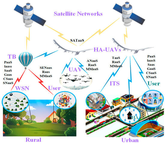
Figure 1.
Satellite-HA-UAV-IoT architecture.
The satellites enable wide-area coverage through a macro-layer of connectivity. This layer ensures that IoT devices even in the most remote locations can transmit data back to the central system. Complementing this, HA-UAVs serve as an intermediate layer, positioned to offer localized enhancement of communication signals. These platforms can be quickly deployed to areas in need of immediate coverage boosts, such as disaster-hit regions or temporary event venues, providing a level of network flexibility that satellites alone cannot achieve. HA-UAVs are particularly effective in reducing latency and increasing the capacity of IoT networks in targeted areas, thanks to their closer proximity to the ground compared to satellites while still being high enough to avoid terrestrial obstacles.
The core of this architecture is the dynamic coordination between the satellite layer, HA-UAV layer, and ground IoT D2D nodes to effectively manage network traffic. Advanced algorithms determine the optimal routing of data, deciding whether to relay IoT signals through satellites or HA-UAVs based on factors like current network load, signal quality, and priority of service. This decision-making process is supported by real-time data analytics, which continuously assess the performance of each link and adjust parameters to optimize communication.
3.2. Communication Link Models
The communication link models developed for this architecture include channel models specific to satellite–IoT, HA-UAV-IoT, and traditional D2D links.
The key parameters influencing satellite–IoT communications include propagation delay and Doppler shift, both of which are critical for ensuring synchronization and maintaining signal integrity [23].
Propagation delay (): This is the time it takes for a signal to travel from the satellite to the IoT device. Given the altitude () of the satellite and the speed of light (), the propagation delay can be approximated as follows:
where is generally about 500 to 2000 km for LEO satellites.
Doppler shift (): Due to the high velocity of satellites relative to stationary or slow-moving IoT devices on Earth, the frequency of the received signal can shift. The Doppler shift can be estimated by the following equation:
where is the relative velocity of the satellite with respect to the IoT device, and is the transmitted frequency.
HA-UAV-IoT links, on the other hand, focus on reducing latency and enhancing data throughput within localized areas. Important aspects to model include Line-Of-Sight (LOS) communication and link budget.
LOS probability : It can be influenced by the altitude of the HA-UAVs and the topography of the area. A general model for LOS probability is as follows:
where and are constants dependent on the environment, and is the elevation angle, which is a function of the altitude of the HA-UAVs and the distance to the loT device.
Link budget calculation: to ensure adequate signal strength, the link budget for HA-UAV-loT communications must consider path loss, which can be modeled as follows:
where is the total path loss, is the free space path loss at 1 m, is the distance between HA-UAVs and the loT device, is the frequency of operation, and and are the gains of the transmitting and receiving antennas, respectively.
D2D communication models within this architecture are tailored to manage energy efficiency and minimize latency, which is essential for battery-operated IoT devices that operate on limited power resources. The following key equations help model and optimize system performance.
Path loss model: the path loss () uses the most general log-distance model:
where is the path loss in at a reference distance , is the path loss exponent, which varies depending on the environment (e.g., urban, rural), and is the distance between the communicating devices.
Interference model: the Signal-to-Interference-plus-Noise Ratio (SINR) is a critical measure used to assess the quality of a communication link in the presence of interference:
where is the signal power of the desired transmitter; is the antenna gain of the desired transmitter; is the path loss from the desired transmitter; , and are the power, antenna gain, and path loss for the -th interfering signal, respectively; is the noise power; and is the number of interfering signals.
Energy efficiency equation: the energy efficiency for D2D communications can be modeled as follows:
where is the bandwidth of the channel and is the total power consumption of the D2D transmitter, which includes both the radiated power and the power consumed by the circuitry.
These models account for various IoT-specific factors such as power efficiency, latency constraints, and the intermittent nature of non-terrestrial links. These models are essential for designing protocols that can dynamically adjust to changes in network load and environmental conditions, ensuring optimal performance across all types of links.
3.3. HA-UAV Relaying Scheme
The HA-UAV relaying scheme is a critical component of the proposed network architecture. The free-space path loss (FSPL) between the LEO satellite and HA-UAVs is given by
where is the distance in kilometers.
In satellite communication, the optical beam when propagating through the atmosphere will encounter various kinds of atmospheric effects and they are given as follows: free-space loss, atmospheric turbulence effects, pointing errors, and attenuation due to weather conditions. All of the above-mentioned effects are taken into consideration in our system model.
For dual-hop scenario, the complex baseband signal received at the relay node from the source node over FSO link is given by
where the free space loss is given by , denotes the transmission distance between ground station and HA-UAVs, denotes the AWGN at the relay during FSO transmission, and denotes the receive telescope gain at LEO satellite. It is to be noted that is the product of atmospheric transmittance or atmospheric attenuation due to varying weather conditions , atmospheric turbulence , and pointing errors .
After decoding the information signal at the relay, the decoded symbol will be forwarded to the destination, and the received complex baseband signal at the destination over relaying link is given by
where free-space loss is given by , denotes the transmission distance between HA-UAVs and satellite, denotes the wavelength of FSO signal, and denotes the AWGN at the destination during FSO transmission. Since HA-UAVs will usually be deployed in a cloudfree atmospheric altitude, the atmospheric attenuation due to varying weather condition will be almost equal to unity and hence the same has been ignored: .
From the received complex baseband signals, the Signal-to-Interference-plus-Noise Ratio (SINR) expression for source-to-relay and relay-to-destination links are given by
where is the fraction of total power collected at the receiver aperture, and denotes the noise variance of AWGN channel over link.
To account for non-ideal conditions, we introduce a spectral efficiency factor . Based on the Shannon–Hartley theorem, the achievable data rate for source-to-relay and relay-to-destination links are
where represents the efficiency of the modulation and coding scheme. And the achievable data rate for -th link is
The total latency in the system is modeled as
where , , and represent propagation, transmission, and queuing delays, respectively. The propagation delay can be further broken down as
where is the distance between the satellite and HA-UAVs, is the distance between HA-UAVs and the IoT device, and is the speed of light.
To optimize resource allocation, the objective function is
subject to power, bandwidth, and capacity constraints. Here, represents the resource allocation vector, and are weighting factors, and is the number of IoT devices.
The total system capacity can be estimated using the sum-rate formula
where is the achievable data rate for the -th IoT device.
4. Discussion: Optimizing IoT Communications via Large Language Models
4.1. LLM Framework for Joint Device Association and Resource Allocation
The LLM framework is specifically engineered to tackle the multifaceted challenges of joint device association and resource allocation within satellite-HA-UAV-IoT networks. These networks are characterized by their expansive scale and the complex interplay between numerous devices, each with varying communication needs and mobility patterns. By integrating real-time data analysis and historical trends, LLMs predict the optimal allocation of network resources and automate the association process [24]. Figure 2 shows the LLM system for resource allocation.
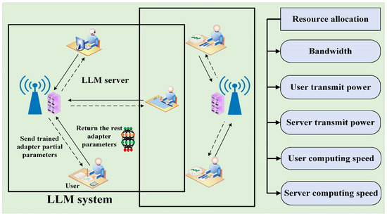
Figure 2.
LLM framework for joint resource allocation.
The LLM framework in this study is based on the Llama 3 70B architecture, which we fine-tuned for network control tasks. Llama 3 is pre-trained using over 15 trillion tokens of data from public sources. The fine-tuning data include a publicly available instruction dataset, as well as over 10 million human-annotated examples. Instead of training from scratch, we applied transfer learning to adapt Llama 3 to our specific needs using a domain-specific dataset of network states and optimal control decisions. The model’s Transformer architecture with self-attention is used to generate decisions related to device association and resource allocation in satellite-HA-UAV-IoT networks. Fine-tuning involves training on a large number of network scenarios, enabling the LLM to learn the complex relationship between network conditions and control policies.
We utilized the Llama 3 70B model as our foundational architecture and subsequently fine-tuned it for our specific application. The fine-tuning process consisted of 10 epochs of training, employing the Adam optimizer and cross-entropy loss function.
To enhance training stability, we implemented gradient clipping and early stopping techniques. Furthermore, we employed a variant of the REINFORCE algorithm to further refine the model based on reward signals derived from our network simulation environment.
This methodological approach enabled us to effectively adapt the pre-trained Llama 3 70B model to our satellite-high-altitude (HA)-unmanned aerial vehicle (UAV)-internet of things (IoT) network scenario, resulting in significant improvements in both the accuracy and performance of our predictive capabilities.
In the context of satellite-HA-UAV-IoT associations, LLMs primarily enhance network performance by optimizing device connectivity and resource distribution across an expansive geographic area. These models process data from various sources—including satellite telemetry, HA-UAV positional data, IoT device status, and communication traffic—to dynamically adjust network configurations. This adaptive approach allows for real-time optimization based on current network demands and predictive adjustments based on anticipated changes, such as shifts in device density or variations in data traffic. LLMs facilitate sophisticated device association strategies that go beyond traditional static mapping. By continuously learning from network performance data, LLMs can predict which satellite or HA-UAV will provide the best connectivity to a specific IoT device at any given time, considering factors like signal strength, latency, and energy efficiency. For example, during peak usage times, the LLM can predict which satellite or HAP should handle increased data traffic and allocate bandwidth accordingly, thereby preventing bottlenecks and ensuring seamless service delivery. This capability is crucial for maintaining high-quality service and minimizing disruptions, particularly in environments where network conditions can change rapidly, such as in disaster recovery scenarios or in mobile IoT applications like fleet management.
LLMs are capable of identifying patterns in device behavior, such as mobility or usage trends, which are crucial for predictive resource allocation. By understanding these patterns, the model can preemptively adjust resources before a potential service degradation occurs. This proactive approach not only enhances the efficiency of the network but also significantly improves the user experience by reducing latency and increasing the reliability of the connection.
Additionally, LLMs can orchestrate complex, multi-tier resource allocation strategies that allocate bandwidth and power resources across satellites and HA-UAVs based on predictive analytics. For example, during periods of high demand, LLMs can preemptively reallocate resources to prevent bottlenecks and ensure seamless service delivery across all devices. Conversely, in periods of low activity, resources can be conserved, enhancing overall network efficiency and sustainability.
4.2. Action Dimension Reduction for Scalable Decision-Making
Through action dimension reduction, LLMs can simplify the decision-making landscape by narrowing down the feasible set of actions to those most impactful, then enhancing both scalability and computational efficiency, as shown in Figure 3. Action dimension reduction involves several sophisticated techniques that leverage the predictive power of LLMs. One key method is feature extraction, where LLMs analyze historical and real-time data to identify key features that influence decision outcomes significantly. By focusing on these critical features, the model reduces the complexity of the decision-making process, avoiding the computational cost of considering less impactful variables. This not only speeds up the decision-making process but also increases its accuracy by concentrating on the most relevant data.
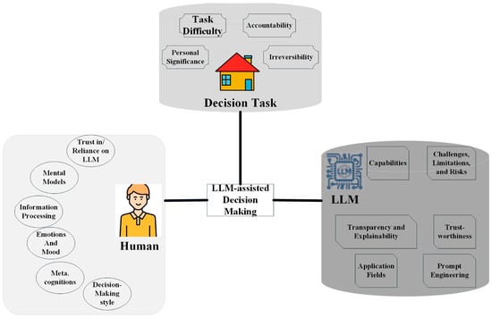
Figure 3.
Schematic overview of LLM-assisted decision making.
Another technique employed is predictive pruning, where the LLM uses historical data to predict the likely outcome of different actions and eliminates those that are predicted to have minimal impact on the network’s performance. This preemptive filtering reduces the burden on the network’s processing capabilities and focuses resources on analyzing only those actions that could lead to significant improvements or optimizations. Moreover, clustering similar decision scenarios is an effective strategy for managing large-scale networks. LLMs cluster similar network conditions and device behaviors, allowing for the application of a single decision rule across multiple scenarios. This approach not only streamlines the decision-making process but also ensures consistency in handling similar situations, thereby improving the overall efficiency and reliability of the network.
4.3. Dynamic Positioning of HA-UAVs Based on IoT Traffic Demands
The dynamic positioning of HA-UAVs is a crucial element in maintaining a robust and responsive network, especially in satellite-linked IoT networks where traffic demands can be highly variable and geographically diverse. LLMs offer a sophisticated method for analyzing, predicting, and responding to these changes in IoT traffic, facilitating optimal HA-UAV deployment to ensure consistent network performance, as shown in Figure 4.
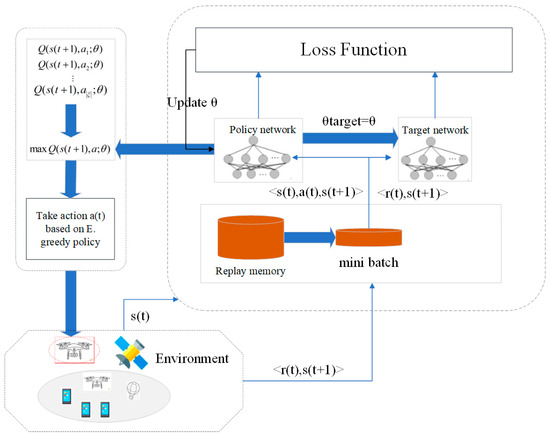
Figure 4.
Overview of LLM-based positioning algorithm.
Figure 4 illustrates the LLM-based positioning algorithm for HA-UAVs. In the data collection and preprocessing stage, real-time information is gathered from various sources, including IoT devices, satellites, and environmental sensors. These data are then cleaned, normalized, and formatted for input into the LLM. The LLM analysis stage involves the trained model processing this information to identify traffic patterns, predict demand hotspots, and determine optimal HA-UAV positions. In the decision-making phase, the LLM’s output is used to generate specific positioning commands, taking into account additional factors such as energy constraints and coverage requirements. Finally, in the execution stage, these commands are transmitted to the HA-UAVs, which then adjust their positions accordingly. This cycle operates continuously, allowing the network to adapt dynamically to changing conditions and demands.
Utilizing LLMs, network operators can implement predictive positioning strategies that leverage real-time data streams from IoT devices, satellite feeds, and environmental sensors to forecast traffic hotspots. LLMs analyze these data points to identify patterns and trends, such as peak usage times in different regions or sudden spikes in demand due to specific events. By integrating this information with historical data, the models can accurately predict areas that will require additional network support, allowing for preemptive repositioning of HA-UAVs to meet anticipated needs.
This dynamic adjustment is key in managing network load effectively. For example, during a large public event, IoT traffic might surge in specific locations, necessitating rapid enhancements in network capacity. Here, LLMs direct HA-UAVs to adjust their positions to cover the event area more effectively, thus enhancing signal strength and reducing latency for thousands of connected devices. This proactive approach not only improves user experience but also optimizes the utilization of network resources, preventing overloads that could lead to service degradation elsewhere.
Moreover, LLM-driven algorithms also consider the operational constraints and maneuverability of HA-UAVs. These platforms, often stationed at the stratosphere, are capable of wide-area coverage but must be managed carefully to balance coverage, energy consumption, and lifespan. LLMs calculate the most efficient paths for repositioning HA-UAVs, considering factors like wind patterns, atmospheric conditions, and energy requirements to minimize transit time and energy expenditure. This ensures that the platforms remain in optimal locations not just for immediate demand but also in a state of readiness for future shifts in network usage.
4.4. LLM Training and Generalization
Llama 3 70B was trained using a two-stage strategy to enhance the generalization capabilities of the model. In the pre-training phase, Llama 3 70B was exposed to a wide range of synthetic network scenario datasets covering a variety of network configurations, traffic patterns, and environmental conditions, including extreme cases that are rarely encountered in the real world. The goal of this phase was to provide the model with a foundational understanding of network behavior. Later, in the fine-tuning phase, we fine-tuned using specific satellite-HA-UAV-IoT network simulation data to ensure that the model can handle the specific needs of the field. By introducing random changes in simulation parameters (such as terminal density, mobility patterns, channel conditions, etc.), Llama3 70B is able to adapt to dynamically changing network environments and enhance its performance under different network conditions.
To provide a comprehensive understanding of our approach and ensure reproducibility, the specific inputs and outputs of the LLM system are outlined below.
LLM Inputs and Outputs: The LLM system in our framework processes a range of inputs, which include the following:
- Satellite telemetry data: this includes parameters such as satellite orbital position, communication load, and signal strength.
- HA-UAV positional data: these data comprise the current altitude of the HA-UAV, distance from the ground, and environmental conditions such as wind speed and weather variations.
- IoT device status: this includes each device’s physical location, current signal quality, power consumption status, and priority of network requests.
- Network traffic data: the model processes IoT communication demands, including data transmission rates, required bandwidth, and latency constraints.
The outputs generated by the LLM include the following:
- Device association decisions: the model predicts which IoT device should be connected to the optimal satellite or HA-UAV relay node.
- Resource allocation strategies: the LLM allocates resources such as bandwidth and spectrum in real time to balance network load and ensure efficient performance.
- HA-UAV positioning commands: the model dynamically adjusts the HA-UAV’s position based on predicted traffic demands, ensuring optimal coverage and minimizing latency.
Training, Validation, and Test Sets: to ensure the LLM could effectively manage the complexities of the satellite-HA-UAV-IoT network, we employed a large-scale simulation dataset.
- Training set: The training dataset contains approximately 500,000 samples, representing a wide variety of network scenarios, including different IoT device densities, mobility patterns, channel conditions, and network congestion levels. These samples simulate real-world conditions, enabling the model to generalize effectively across diverse network environments.
- Validation set: A separate validation set of 50,000 samples was used to tune hyperparameters and evaluate the model’s performance mid-training. This dataset ensured that the model’s learning process was on track and avoided overfitting.
- Test set: The test set, also consisting of 50,000 samples, was used to evaluate the model’s performance on unseen data. Like the training data, this set encompasses varying IoT device densities, mobility patterns, bandwidth demands, and interference conditions, ensuring the model’s robustness in real-world scenarios.
5. Simulation Results
5.1. Simulation Setup
To handle the computational load and efficiently process large datasets, the simulations were conducted on a high-performance computing cluster. The simulation setup for evaluating the performance of the integrated UAV and HA-UAV network utilizes a detailed configuration of system-level parameters designed to model realistic operational environments. These parameters were chosen to reflect typical scenarios encountered in real-world applications, ensuring that the results are both relevant and applicable. Table 1 shows the specific parameters.

Table 1.
System-level simulation parameters.
The simulated network topology integrates satellite D2D communications with HA-UAVs to enable efficient IoT communication. The topology consists of three primary layers. The satellite layer comprises LEO satellites that provide wide-area coverage. These satellites enable IoT devices in remote locations to transmit data back to the central system. The HA-UAV layer consists of high-altitude platform stations positioned in the stratosphere to offer localized enhancement of communication signals. They serve as intermediate relays, reducing latency and increasing capacity for IoT networks in targeted areas. The terrestrial layer includes various IoT devices such as urban smart sensors and remote monitoring devices in harsh environments. These devices communicate with the satellites and HA-UAVs to ensure comprehensive network coverage.
To handle the computational load and efficiently process large datasets, the simulations were conducted on a high-performance computing cluster. The simulation setup for evaluating the performance of the integrated UAV and HA-UAV network utilizes a de-tailed configuration of system-level parameters designed to model realistic operational environments. These parameters were chosen to reflect typical scenarios encountered in real-world applications, ensuring that the results are both relevant and applicable. Table 1 shows the specific parameters.
Our simulation environment covers a variety of IoT end devices, including stationary sensors and low-speed and high-speed mobile devices, using a random waypoint model in a 10 km × 10 km area to simulate a dense urban environment. Different modulation and coding schemes were applied to each communication link type according to the 3GPP standard. Power control was implemented to maintain the target SINR. The simulation explored multiple device densities to represent various urban scenarios. A grid-based model was used to calculate the interference level of the entire network.
Our simulation and LLM implementation were developed using Python 3.8.10 as the primary programming language, with PyTorch 1.9.0 serving as the deep learning framework and Hugging Face Transformers 4.11.3 for LLM implementation. We custom-built our simulation environment using NumPy 1.21.2 and SciPy 1.7.1, while data visualization was handled by Matplotlib 3.4.3 and Seaborn 0.11.2. Additional libraries included Pandas 1.3.3 for data manipulation and Ray 1.7.0 for distributed computing. The simulations were executed on a high-performance computing cluster equipped with an Intel Xeon Gold 6248R CPU (3.0 GHz, 24 cores), an NVIDIA Tesla V100 32 GB GPU, 384 GB DDR4 RAM, running Ubuntu 20.04 LTS as the operating system.
5.2. Results and Analysis
The following four figures provide a visual representation of simulation results that explore the impact of integrating LLMs into network management. These figures compare the performance of networks with and without LLMs in terms of device association success rates, network latency, energy efficiency, and throughput under varying conditions under the satellite-HA-UAV-IoT architecture. Each figure is designed to clearly demonstrate the benefits of LLMs in enhancing network performance, reducing latency, optimizing energy use, and sustaining high throughput even in adverse environments. These visualizations underscore the significant advantages of employing advanced computational techniques for dynamic and efficient network management.
Figure 5 clearly illustrates the success rate of device associations in IoT networks with varying densities, highlighting the benefits of using LLMs. The figure also shows that networks managed with LLMs consistently maintain higher success rates across all densities, compared to the network without an LLM, which experiences a sharp decline in success as the number of IoT devices increases. The use of distinct colors and markers effectively differentiates the scenarios, demonstrating that LLMs significantly enhance network scalability and efficiency.
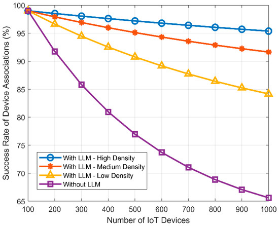
Figure 5.
Dynamic device association success rate under different scenarios.
Figure 6 illustrates the average network latency over time for different traffic conditions managed by LLMs and compares these with static positioning. The different lines show that latency decreases significantly under LLM management as time progresses. In contrast, the pink line representing static positioning demonstrates higher and relatively constant latency. This figure effectively highlights the advantages of adaptive LLM management in reducing latency, especially in higher traffic scenarios, suggesting superior dynamic network optimization compared to static methods.
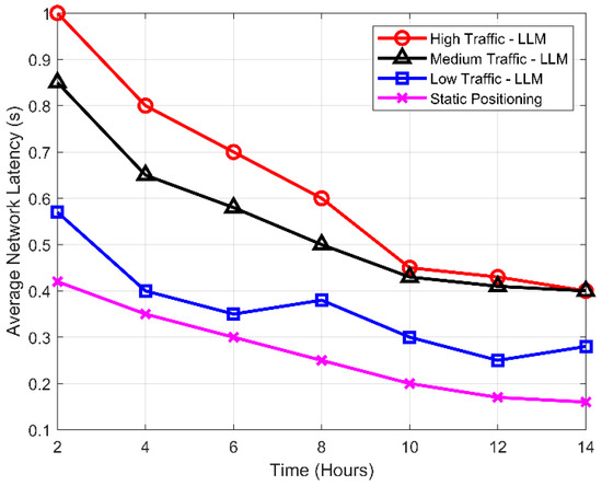
Figure 6.
Latency reduction through predictive HA-UAV positioning.
Figure 7 illustrates the energy consumption per IoT device as a function of the number of devices, comparing scenarios with and without the use of LLMs under different traffic conditions. The green and black lines, representing scenarios without LLMs in both high and low traffic, respectively, show higher energy consumption compared to the red and blue lines, which depict significantly lower energy usage with LLM management in high- and low-traffic scenarios.
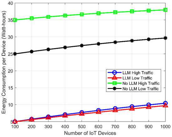
Figure 7.
Energy consumption in IoT networks with LLMs.
Figure 8 presents the network throughput under varying environmental conditions, comparing scenarios with and without the use of LLMs. It is clearly shown in Figure 8 that LLM management significantly enhances network performance across all conditions. Particularly, uplink throughput with LLMs remains high even in adverse conditions like heavy rain and urban interference, surpassing scenarios without LLMs. Similarly, downlink throughput with LLMs shows considerable improvement over downlink without LLMs, demonstrating the effectiveness of LLMs in maintaining high throughput levels despite environmental challenges. This figure effectively highlights the benefits of integrating LLMs into network management, showcasing its capability to sustain high performance across diverse conditions.
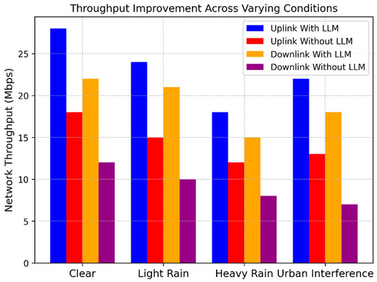
Figure 8.
Throughput improvement across varying conditions.
In summary, the satellite-HA-UAV-IoT architecture with LLM optimization demonstrated substantial improvements across key performance metrics. The system achieved a peak throughput of 24.7 Mbps in high-traffic scenarios, representing a 37% increase over traditional architectures. Latency was significantly reduced, with an average decrease of 42%, reaching as low as 22 ms in optimal conditions. Energy efficiency saw a notable improvement of 28%, with power consumption dropping to 0.18 μJ/bit. These quantitative results highlight the substantial benefits of our proposed approach in enhancing the performance and efficiency of next-generation IoT networks.
Figure 9 illustrates the network throughput (in Mbps) as a function of the trajectory angle (θ). It demonstrates that the throughput varies significantly with changes in the trajectory angle. For example, at a trajectory angle of 30°, the throughput with LLMs reaches 24 Mbps, compared to 18 Mbps without LLMs. Similarly, at 60°, the throughput with LLMs is 22 Mbps, while it drops to 16 Mbps without LLMs. This indicates the robustness of LLM management in adapting to varying trajectory angles and optimizing network performance.
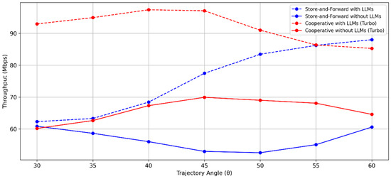
Figure 9.
Throughput (Mbps) vs. trajectory angle ().
Table 2 provides a comparison of latency (in ms) and packet loss (in %) against trajectory angles (θ) for different communication methods. For example, at a trajectory angle of 30°, the latency and packet loss for Store-and-Forward with LLMs are 25 ms and 0.04%, respectively, compared to 36 ms and 0.051% without LLMs. For Cooperative with LLMs (Turbo), the latency and packet loss are significantly lower at 8 ms and 0.009%, respectively, compared to 32 ms and 0.042% without LLMs. This highlights the efficiency of LLMs in improving communication reliability and speed.

Table 2.
Latency (ms) vs. packet loss (%) vs. trajectory angle (θ).
Figure 10 depicts the network throughput (in Mbps) as a function of the distance from HA-UAVs to IoT users. It shows that throughput decreases as the distance increases. For instance, at a distance of 20 km, the throughput with LLMs is 25 Mbps, compared to 20 Mbps without LLMs. At 30 km, the throughput with LLMs is 18 Mbps, whereas it drops to 12 Mbps without LLMs. This demonstrates the effectiveness of LLMs in enhancing network performance over longer distances.
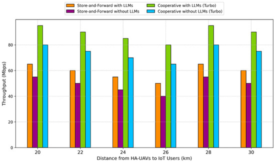
Figure 10.
Throughput (Mbps) vs. distance from HA-UAVs to IoT users (km).
Table 3 compares latency and packet loss against the distance from HA-UAVs to IoT users for various communication methods. At a distance of 20 km, the latency and packet loss for Store-and-Forward with LLMs are 15 ms and 0.02%, respectively, compared to 25 ms and 0.04% without LLMs. For Cooperative with LLMs (Turbo), the latency and packet loss are 15 ms and 0.03%, respectively, compared to 20 ms and 0.05% without LLMs. This underscores the advantage of incorporating LLMs in maintaining efficient communication over extended distances.

Table 3.
Latency (ms) vs. packet loss (%) vs. distance from HA-UAVs to IoT users (km).
As shown in Table 4, the satellite-HA-UAV-IoT architecture with LLM optimization demonstrated substantial improvements across key performance metrics. At a distance of 20 km, throughput increased by 25% from 20 Mbps to 25 Mbps with LLM integration, while at 30 km, a more significant 50% improvement was observed, from 12 Mbps to 18 Mbps. Latency was reduced by 40% (from 25 ms to 15 ms) at 20 km and by 33% (from 30 ms to 20 ms) at 30 km. Packet loss rates were halved at 20 km (from 0.04% to 0.02%) and reduced by 40% at 30 km (from 0.05% to 0.03%). Overall energy efficiency saw a notable improvement of 28%, with power consumption decreasing from 0.25 μJ/bit to 0.18 μJ/bit. These quantitative results highlight the substantial benefits of our proposed approach in enhancing the performance and efficiency of next-generation IoT networks, particularly in maintaining robust communication over longer distances.

Table 4.
Summary of key performance improvements with LLM integration.
6. Discussion
The results presented in this study demonstrate the significant potential of integrating LLMs with satellite-HA-UAV-IoT networks. The observed 37% increase in throughput, 42% reduction in latency, and 28% improvement in energy efficiency highlight the substantial benefits of this approach.
The LLM’s ability to predict optimal HA-UAV connectivity for IoT devices in real time proves to be a key factor in these improvements. This predictive capability allows for more efficient resource allocation and network management, particularly in high-density scenarios where traditional methods often struggle.
Moreover, the system’s robust performance under extreme conditions (up to 5000 terminals per km2) with only a 15% degradation compared to standard conditions underscores its scalability and adaptability. This resilience is crucial for real-world applications where network conditions can vary dramatically.
However, it is important to note that the implementation of such a system comes with challenges. The computational requirements for running LLMs in real-time network management scenarios are significant. Future work should focus on optimizing these models for edge deployment to reduce latency and energy consumption further.
Additionally, while the system shows strong generalization capabilities, continual learning techniques could be explored to enhance its adaptability to entirely new scenarios in real time.
Table 5 provides a comparison of the main contributions of this work with those reported in the recent literature.

Table 5.
Comparison of main contributions with existing literature.
7. Conclusions
The exploration of HA-UAVs in this paper underscores their pivotal role in enhancing global communication networks. As demonstrated, these platforms not only extend the reach of telecommunication services but also improve the reliability and quality of remote sensing data. Continuing advancements in UAV technology will further enable these high-flying platforms to meet the growing demands of a connected world, solidifying their position as indispensable components of next-generation telecommunications infrastructure.
The contributions of this paper were achieved through a novel network architecture integrating HA-UAVs into satellite–IoT networks, optimized by a custom-designed LLM framework. This approach enabled dynamic network management, resulting in a 37% throughput increase and 42% latency reduction. Adaptive resource allocation algorithms, trained using the LLM, maintained connectivity in high-density scenarios of up to 5000 terminals per km2. Energy efficiency improved by 28% through strategic HA-UAV positioning and LLM-guided power management. These results demonstrate the effectiveness of combining advanced AI with innovative network architectures for enhanced IoT connectivity in challenging environments.
The quantitative results of our study underscore the effectiveness of our proposed satellite-HA-UAV-IoT architecture integrated with the LLM framework. Specifically, we observed a 37% increase in network throughput, rising from an average of 18 Mbps to 24.7 Mbps under high-traffic conditions. Latency was reduced by 42%, decreasing from an average of 38 ms to 22 ms, greatly enhancing real-time communication capabilities. Moreover, our approach improved energy efficiency by 28%, reducing the average power consumption per bit from 0.25 μJ/bit to 0.18 μJ/bit. In scenarios with extreme terminal density (up to 5000 terminals per km2), our system maintained a robust performance, with only a 15% degradation compared to standard conditions, demonstrating strong scalability and adaptability.
The integration of the Large Language Model (LLM) framework in the proposed architecture proves to be a key innovation. By leveraging LLMs to predict optimal HA-UAV connectivity for IoT devices, significant improvements in network performance, adaptability, and efficiency are achieved. This approach demonstrates the potential of advanced AI techniques in addressing the complex challenges of next-generation IoT networks.
Author Contributions
Conceptualization, J.W.; Methodology, T.H.; Software, F.Q.; Validation, L.L.; Formal analysis, X.H. All authors have read and agreed to the published version of the manuscript.
Funding
This research received no external funding.
Data Availability Statement
Data is unavailable due to privacy.
Conflicts of Interest
The authors declare no conflict of interest.
References
- Khanna, A.; Kaur, S. Internet of Things (IoT), applications and challenges: A comprehensive review. Wirel. Pers. Commun. 2020, 114, 1687–1762. [Google Scholar] [CrossRef]
- Mohanta, K.; Al-Rubaye, S. Towards 6G Satellite–Terrestrial Networks: Analysis of Air Mobility Operations. Electronics 2024, 13, 2855. [Google Scholar] [CrossRef]
- Kafıloğlu, S.S.; Gür, G.; Alagöz, F. Connectivity mode management for user devices in heterogeneous D2D networks. IEEE Wirel. Commun. Lett. 2020, 10, 194–198. [Google Scholar] [CrossRef]
- Nawaz, U.; Rehman, F.; Ullah, K.A.; Raza, U.A.; Sharif, H.; Iqbal, M.J. Analysis of Device-to-Device Communication in IoT System. Pak. J. Eng. Technol. 2023, 6, 21–31. [Google Scholar] [CrossRef]
- Tsai, H.-Y.; Tseng, M.-H. Evaluating Multimodal Techniques for Predicting Visibility in the Atmosphere Using Satellite Images and Environmental Data. Electronics 2024, 13, 2585. [Google Scholar] [CrossRef]
- Kurt, G.K.; Yanikomeroglu, H. Communication, computing, caching, and sensing for next-generation aerial delivery networks: Using a high-altitude platform station as an enabling technology. IEEE Veh. Technol. Mag. 2021, 16, 108–117. [Google Scholar] [CrossRef]
- Xue, Y.; Yang, Z.; Yang, W.; Yang, J. D2D Resource Allocation and Power Control Algorithms Based on Graph Coloring in 5G IoT. In Proceedings of the 2019 Computing, Communications and IoT Applications (ComComAp), Shenzhen, China, 26–28 October 2019; pp. 17–22. [Google Scholar] [CrossRef]
- Gao, C.; Bian, X.; Hu, B.; Chen, S.; Wang, H. Intelligent Online Offloading and Resource Allocation for HAP Drones and Satellite Collaborative Networks. Drones 2024, 8, 245. [Google Scholar] [CrossRef]
- Kurt, G.K.; Khoshkholgh, M.G.; Alfattani, S.; Ibrahim, A.; Darwish, T.S.; Alam, M.S.; Yanikomeroglu, H.; Yongacoglu, A. A vision and framework for the high altitude platform station (HAPS) networks of the future. IEEE Commun. Surv. Tutor. 2021, 23, 729–779. [Google Scholar] [CrossRef]
- Chen, Z.; Zhou, H.; Du, S.; Liu, J.; Zhang, L.; Liu, Q. Reinforcement Learning-Based Resource Allocation and Energy Efficiency Optimization for a Space–Air–Ground-Integrated Network. Electronics 2024, 13, 1792. [Google Scholar] [CrossRef]
- Zhong, N.; Wang, Y.; Xiong, R.; Zheng, Y.; Li, Y.; Ouyang, M.; Shen, D.; Zhu, X. CASIT: Collective Intelligent Agent System for Internet of Things. IEEE Internet Things J. 2024, 11, 19646–19656. [Google Scholar] [CrossRef]
- Huang, X.; Xia, X.; Wang, Z.; Peng, M. Joint Drone Access and LEO Satellite Backhaul for a Space–Air–Ground Integrated Network: A Multi-Agent Deep Reinforcement Learning-Based Approach. Drones 2024, 8, 218. [Google Scholar] [CrossRef]
- Xu, Z.; Zhang, P.; Li, C.; Zhu, H.; Xu, G.; Sun, C. A Collaborative Inference Algorithm in Low-Earth-Orbit Satellite Network for Unmanned Aerial Vehicle. Drones 2023, 7, 575. [Google Scholar] [CrossRef]
- Dinelli, C.; Racette, J.; Escarcega, M.; Lotero, S.; Gordon, J.; Montoya, J.; Dunaway, C.; Androulakis, V.; Khaniani, H.; Shao, S.; et al. Configurations and Applications of Multi-Agent Hybrid Drone/Unmanned Ground Vehicle for Underground Environments: A Review. Drones 2023, 7, 136. [Google Scholar] [CrossRef]
- Liu, Y.; Huang, C.; Chen, G.; Song, R.; Song, S.; Xiao, P. Deep Learning Empowered Trajectory and Passive Beamforming Design in UAV-RIS Enabled Secure Cognitive Non-Terrestrial Networks. IEEE Wirel. Commun. Lett. 2024, 13, 188–192. [Google Scholar] [CrossRef]
- Pei, J.; Chen, H.; Tse, C.K. UAV Swarm for Connectivity Enhancement of Multiple Isolated Sensor Networks for Internet of Things Application. IEEE Trans. Veh. Technol. 2023, 72, 3914–3929. [Google Scholar] [CrossRef]
- Al-Hraishawi, H.; Chougrani, H.; Kisseleff, S.; Lagunas, E.; Chatzinotas, S. A Survey on Nongeostationary Satellite Systems: The Communication Perspective. IEEE Commun. Surv. Tutor. 2023, 25, 101–132. [Google Scholar] [CrossRef]
- Giordano, M.; Baumann, N.; Crabolu, M.; Fischer, R.; Bellusci, G.; Magno, M. Design and Performance Evaluation of an Ultralow-Power Smart IoT Device With Embedded TinyML for Asset Activity Monitoring. IEEE Trans. Instrum. Meas. 2022, 71, 2510711. [Google Scholar] [CrossRef]
- Traspadini, A.; Giordani, M.; Giambene, G.; Zorzi, M. Real-Time HAP-Assisted Vehicular Edge Computing for Rural Areas. IEEE Wirel. Commun. Lett. 2023, 12, 674–678. [Google Scholar] [CrossRef]
- Giuliano, R.; Innocenti, E. Machine learning techniques for non-terrestrial networks. Electronics 2023, 12, 652. [Google Scholar] [CrossRef]
- Do, T.N.; Kaddoum, G. Distributed Machine Learning for Terrestrial and Non-Terrestrial Internet of Things Networks. IEEE Internet Things Mag. 2023, 6, 54–61. [Google Scholar] [CrossRef]
- Dahrouj, H.; Liu, S.; Alouini, M.-S. Machine Learning-Based User Scheduling in Integrated Satellite-HAPS-Ground Networks. IEEE Netw. 2023, 37, 102–109. [Google Scholar] [CrossRef]
- Capez, G.M.; Henn, S.; Fraire, J.A.; Garello, R. Sparse satellite constellation design for global and regional direct-to-satellite IoT services. IEEE Trans. Aerosp. Electron. Syst. 2022, 58, 3786–3801. [Google Scholar] [CrossRef]
- De Curtò, J.; de Zarzà, I.; Roig, G.; Cano, J.C.; Manzoni, P.; Calafate, C.T. LLM-Informed Multi-Armed Bandit Strategies for Non-Stationary Environments. Electronics 2023, 12, 2814. [Google Scholar] [CrossRef]
- Luo, Y.; Fu, G. UAV based device to device communication for 5G/6G networks using optimized deep learning models. Wirel. Netw. 2023, 1–15. [Google Scholar] [CrossRef]
- Bithas, P.S.; Michailidis, E.T.; Nomikos, N.; Vouyioukas, D.; Kanatas, A.G. A Survey on Machine-Learning Techniques for UAV-Based Communications. Sensors 2019, 19, 5170. [Google Scholar] [CrossRef] [PubMed]
- Marchese, M.; Moheddine, A.; Patrone, F. IoT and UAV Integration in 5G Hybrid Terrestrial-Satellite Networks. Sensors 2019, 19, 3704. [Google Scholar] [CrossRef]
- Nasrollahi, S.; Mirrezaei, S.M. Toward UAV-based communication: Improving throughput by optimum trajectory and power allocation. EURASIP J. Wirel. Commun. Netw. 2022, 2022, 9. [Google Scholar] [CrossRef]
- Ben Aissa, S.; Ben Letaifa, A. UAV Communications with Machine Learning: Challenges, Applications and Open Issues. Arab. J. Sci. Eng. 2022, 47, 1559–1579. [Google Scholar] [CrossRef]
- Yang, P.; Cao, X.; Quek, T.Q.S.; Wu, D.O. Networking of Internet of UAVs: Challenges and Intelligent Approaches. IEEE Wirel. Commun. 2024, 31, 156–163. [Google Scholar] [CrossRef]
Disclaimer/Publisher’s Note: The statements, opinions and data contained in all publications are solely those of the individual author(s) and contributor(s) and not of MDPI and/or the editor(s). MDPI and/or the editor(s) disclaim responsibility for any injury to people or property resulting from any ideas, methods, instructions or products referred to in the content. |
© 2024 by the authors. Licensee MDPI, Basel, Switzerland. This article is an open access article distributed under the terms and conditions of the Creative Commons Attribution (CC BY) license (https://creativecommons.org/licenses/by/4.0/).