Review

Review: Using Unmanned Aerial Vehicles (UAVs) as Mobile Sensing Platforms (MSPs) for Disaster Response, Civil Security and Public Safety

by
Hanno Hildmann
1,* and
Ernö Kovacs
2
1
Netherlands Organization for Applied Scientific Research (TNO), Oude Waalsdorperweg 63, 2597 AK The Hague, The Netherlands
2
NEC Research Labs Europe (NLE), Kurfürsten-Anlage 36, 69115 Heidelberg, Germany
*
Author to whom correspondence should be addressed.
Drones 2019, 3(3), 59; https://doi.org/10.3390/drones3030059
Submission received: 30 April 2019 / Revised: 17 July 2019 / Accepted: 20 July 2019 / Published: 25 July 2019

Abstract

:
The use of UAVs in areas ranging from agriculture over urban services to entertainment or simply as a hobby has rapidly grown over the last years. Regarding serious/commercial applications, UAVs have been considered in the literature, especially as mobile sensing/actuation platforms (i.e., as a delivery platform for an increasingly wide range of sensors and actuators). With regard to timely, cost-effective and very rich data acquisition, both, NEC Research as well as TNO are pursuing investigations into the use of UAVs and swarms of UAVs for scenarios where high-resolution requirements, prohibiting environments or tight time constraints render traditional approaches ineffective. In this review article, we provide a brief overview of safety and security-focused application areas that we identified as main targets for industrial and commercial projects, especially in the context of intelligent autonomous systems and autonomous/semi-autonomously operating swarms. We discuss a number of challenges related to the deployment of UAVs in general and to their deployment within the identified application areas in particular. As such, this article is meant to serve as a review and overview of the literature and the state-of-the-art, but also to offer an outlook over our possible (near-term) future work and the challenges that we will face there.

1. Introduction

In the past decade, autonomously operating Unmanned Aerial Vehicles (UAVs), often referred to as airborne drones or simply as drones, have become a mass-market technology. In the academic literature, they are referred to under a number of acronyms such as UAVs [1], UASs (Unmanned Aerial Systems) [2], RPAs (Remotely Piloted Aircrafts) [3] or ROAs (Remotely Operated Aircrafts) [4]. Their operational use dates back to at least as far as the Vietnam War [5]. Due to the recent decrease in cost and improved performance of virtually all of their relevant sub-systems, they have become a commercially available technology, affordable to the wider public. Their use in swarms and in collaboration with other autonomously operating cyber–physical systems is already being investigated by a plethora of research projects [6,7,8,9] and studies [10,11]. Such collectives of cooperating devices often solve problems far more efficiently than a single device, especially in environments subject to continuous change. In [12] the authors identify 3 categories of applications which are currently attracting a lot of attention from the community: (1) formation control and self-assembly methods ([11,13,14,15,16,17,18,19]), (2) localization and search methods ([20,21,22,23,24]) and (3) techniques for solving optimization problems ([25,26,27]). Furthermore, ref [12] highlights the ability to sense as an integral basic functionality.
Indeed, in the literature, there is increasing reference made to the potential [28] of using UAVs as autonomous or semi-autonomous operating data acquisition platforms, often referred to as Mobile Sensing Platforms (MSPs). They can be equipped with state-of-the-art measurement instruments offering extremely high resolution and are ideally suited to access otherwise prohibitingly inaccessible locations or to operate in hostile environments that would be lethal to the human operator.
A recent survey [10] identified the same application areas for UAVs that we focus on in this article (with the only omission by us being Precision Agriculture); this is summarized in the table in Table 1.
While Table 1 is certainly not a comprehensive overview over all application areas, the referenced literature is extensive in scope, and the application areas identified have attracted a significant of attention and we believe them to be prominent areas deserving separate consideration. In this article we focus on two application domains, namely the area of smart cities & public safety (Section 2) as well as the use of UAVs for civil security & in disaster response (Section 3). Within these areas, we especially consider collaborative actions of groups of UAVs forming a multi-agent swarm [6,9].
For each of these areas, we distinguish applications as belonging to three categories (which may overlap): we consider sensing and acting capabilities and tasks separately and treat the combination of more than one of these as a service. For each of the two areas, we report on area-specific applications found in the literature, separated by category (in Section 2.3 and Section 3.3, respectively). We further identify the advantages of using UAVs in these areas (in Section 2.4 and Section 3.4, respectively).
In addition, in Section 4, we address the challenges we believe to be most prominent. We have restricted our investigations to three domains: UAV communication and communication infrastructure (Section 4.1) because these challenges need to be addressed to operate UAVs and espcially UAV-swarms, hardware and software issues and choices (Section 4.2) which amongst other aspects are a financial and a performance issue, and finally, the general matter of operating UAVs in the wild (Section 4.3) because with the increasing popularity of UAVs comes a plethora of legal and ethical questions.
The authors’ work in the last 7 years has been in the identified areas and has focused on the design of novel approaches and algorithms to optimize the collective performance of swarms of UAVs (cf. [35,36,37,38,39]), addressing some of the communication and collaboration aspects, identified as challenges. Our work has been practically applied and tested using a test-bed developed for the operating of hybrid swarms of up to 25 devices [36] such as the one shown in Figure 1.

2. Application Area: Smart Cities and Public Safety

2.1. Introduction to Smart Cities and Public Safety

UAVs can serve as flexible mobile platforms for a plethora of smart city applications [40] and, as [41] postulates “could make a remarkable improvement in public safety”. In today’s world, where half of the global population is already living in urban areas [42], the improvement of services and quality of life in these areas becomes increasingly important. The UN predicts that by 2050, more than 70% of the global population will be living in cities. There will be dozens of so-called megacities [42], i.e., metropolitan areas spanning multiple cities and exceeding a population of 10 million each. In these areas wireless communication technologies will take an increasingly central role and replace wired or physically connected technologies [43]. Owing to the decreasing size and cost for such wireless devices (and specifically for passive and active sensors [44]), the number of connected devices in the so-called Internet-of-Things (IoT) will reach approximately 50 billion wireless devices by the year 2020 [45].
Due to this, the concept of a smart city is becoming a popular topic for practitioners operating services in large urban areas. As [46] describes it, “[a] Smart City incorporates information and communication technologies to reduce costs, optimize resource consumption, improve interactivity and improve quality of life for its citizens”. The benefits (and, arguably, the driving factors) of incorporating information and communication technologies in smart city infrastructure is the expected reduction in cost, optimization of resource consumption and potential to improve the quality of life of the city’s residents in general [46]. According to [40] we will see see advances in the areas of cloud computing, wireless sensors, networked unmanned systems as well as big/open data over the next few years. These advances will make it possible to use UAVs as flexible and mobile platforms (potentially operating in swarms [6,9]) and to integrate them into the smart city infrastructure.

2.2. Mission Types for UAVs in Smart Cities for Public Safety

The market for UAVs is expanding rapidly as new applications are emerging [47], with new models and suppliers entering the market frequently. Due to recent and ongoing advances (cf. Section 4.2 on UAV-related software and hardware), UAVs have been able to serve as aerial video surveillance systems [48], providing unprecedented aerial perspective for ground monitoring, and moreover, doing so in real time [49]. Urban environments and their landscape with high rise buildings and urban canyons, pose a number of challenges which are acknowledged by the literature, (e.g., [50]).
There are many opportunities to employ UAVs in the context of smart cities and public safety: for example, ref [51] lists the following applications as relevant domains:
  • Public Safety and Civil Security
  • Emergency/Disaster Monitoring and Control
  • Traffic and Crowd Management
  • Security for Public Events
  • Environmental Management
  • (Big) Data Generation
  • Surveying
  • Coordination between heterogeneous systems

2.2.1. Mobile Aerial Communication Infrastructure

While flying video surveillance systems [48] are maybe the most popular vision of the future in pop-culture, so-called flying cellular networks [52] are receiving by far the most attention in the research community (in the context of publications we refer to [52,53,54,55,56,57,58,59,60,61,62], all of which report on UAV-based aerial communication infrastructure to deliver broadband wireless connectivity or for UAV-based mobile wireless access networks). In contrast to the normal wireless access networks such as cell networks for mobile phones which ultimately rely on a wired infrastructure-based network [55], a UAV-based wireless access networks could be relatively independent from fixed entry points to the back haul network because even if they can not provide a complete airborne connection, they can dynamically change their topology and the back haul entry points they connect to.

2.2.2. Smart City Sensing

One fundamental aspect of a smart city is its sensing capability, provided through a large number of sensors deployed [57]. But the deployment of these sensors is only part of the required infrastructure, as the generated data has to be collected and aggregated to support informed decision making. UAVs can play an essential role in providing a mobile wireless sensor network [54,57,62], network relay connectivity and situational awareness [63]. They are expected to communicate with many different smart objects, such as sensors and embedded devices [64]. Their mobility [61], the ability to provide real-time data [65] and the potential to carry hardware for on-board decision making [66] make UAVs the ideal candidate. Indeed, as projected by in [63], UAVs are expected to play a critical role in smart cities and city-wide IoT (Internet-of-Things) infrastructure.

2.2.3. Intelligence Gathering

The use of Unmanned Aerial Vehicles (UAVs) in civil defence applications has increased due to their portability and low operational costs [67]. To spread the cost for procuring and operating such devices, further multiple agencies can cooperate and form a consortium [68] that shares resources and, more importantly, the data collected by these devices (such as imagery or live video feeds). As proposed in [69], UAVs can be used to locate civil security units such as fire fighters or policemen if they are equipped with transponders. This would further enhance the situational awareness and could be used between agencies to coordinate operations or to improve the security of the units in the field.
The majority of the fastest growing urban areas are in Asia, Africa or the Middle East and many of them are in costal regions. Port security is a major factor in those cities as ports involve many continuously changing moving objects as well as large commercial and industrial sites and infrastructure. The ability to deploy sensing capabilities at will to identify objects and activities of interest is desirable. As discussed in [70] multiple UAVs could work together near/over water or the open sea. To further extend the operational reach water-based autonomous vehicles (Unmanned Surface Vehicles, USVs) can be included (cf. [70,71]) to cooperate with the aerial units [70].

2.2.4. Monitoring

The use of UAVs in the context of disaster response is discussed in Section 3 where we focus on the applications deployed in the aftermath of a disaster. To avoid repeating ourselves we consider any application primarily designed for disaster mitigation (i.e., done to avoid a disaster altogether or to at least reduce the resulting impact) as falling under the category of public safety (and thus include these applications in the current section).
Industrial facilities and plants pose substantial risks due to hazardous materials used on these sites. Especially toxic gases are very problematic as they are often invisible to the naked eye, making the tracking of spillage more difficult than e.g., oil spills. Gas monitoring [72] in man-made disasters can be extremely important if there is even a potential for gas leakage. Unfortunately, the worst industrial disaster (Bhopal, India, 1984) involved gas and killed thousands of people and left more than half a million injured. As described in [57], smart cities in the future will have to operate large numbers of sensors distributed over the city to collect the data needed to generate reliable environmental surveillance of an area. UAVs connected to the infrastructure will play a critical role in this and their part in network relay connectivity and situational awareness will be essential [63]. An example of overlapping application domains is proposed in [73]: UAV-based gas monitoring to actively support evacuation measures (civil safety) in gas of a gas leak such as the one in Bhopal (disaster response) by continuously providing real-time measurements for the areas currently used as evacuation corridors.

2.3. Application Types for UAVs in Smart Cities for Public Safety

2.3.1. Sensing & Monitoring Applications

A variety of UAV-based smart city applications have been reported in the literature. Broadly speaking, the main contribution from UAVs to smart city applications will be their ability to serve as mobile sensing platforms MSPs. As such, they can operate in three spacial dimensions (i.e., get close to objects even if these are at a distance from the ground, assume elevated positions above locations or objects of interest and chose their position on the basis of it being sustainable and not affecting other participants of smart city operations), are not restricted by congested networks on the ground and can autonomously adapt their exact location and the settings of their sensors to deliver the best possible service. Platform mounted sensors can contribute to public safety in the areas of imagery [65,74,75], monitoring [34,40,53,69,74,76,77,78,79,80,81,82,83,84,85,86,87,88] and surveillance [34,40,46,48,53,78,82,87,89,90,91].

2.3.2. Actuation Applications

With regard to the acting capabilities and the potential for using UAVs in a smart city, there are a lot of applications that are mentioned in recent literature. While the obvious advantage of less power demanding operations during passive activities such as sensing will probably be favored until more efficient flight is achieved and lighter and better batteries are available, the applications that make use of active interactions of the drones with the environment are already numerous. The main example for acting drones is the use of UAVs as a mobile aerial communication infrastructure [54,92], specifically in the domains of delivering wireless broadband [52,53,55,56,58,59,60,61,92,93] and, more low-tech, VHF/UHF radio coverage. The latter is especially relevant during emergencies [92].
In addition, UAVs can be used for inspection and repair tasks [81] that require autonomous manipulation [94] or simply for logistic operations [81] to e.g., deliver packages [33,34,80]. However, the vast majority of active contributions to civil defence and public safety operations is found in the use of on-board processing capabilities that allow a device to process (or at least pre-process) data collected from the sensing applications. This can range from aggregating data for e.g., damage assessment [68] or to provide public safety on beaches [71,95] or ports [71] to interpreting this data to e.g., support civil defence teams on the ground [96,97], locate victims [83] or assess damage [68]. Most of these actuation tasks are described as high-level services.

2.3.3. Services

As already mentioned, UAVs serving as mobile sensing platforms can perform a wide variety of sensing tasks, essentially limited only by the sensors that can be mounted to the platform. As such, the use of UAVs for a broad range of surveillance tasks has been suggested in the literature [40,48,82,87,89,90,91], covering the areas of urban surveillance [46], aerial surveillance [53], border surveillance [34] and tracking and surveillance tasks in general [78]. Furthermore, there is significant literature on the use of UAVs for monitoring purposes [34,40,74,80,81,82,86,98] which can be as diverse as the monitoring of infrastructure [88], specifically pipelines [76] but also of personal [69] and, in case of disasters, victims [83]. Traffic can be monitored [53,68,78] (e.g., counting cars [85] for traffic management [40] and traffic control systems [84]), as can be the environment [40,77,79,87] (e.g., the mapping of vegetation [68]), entire ecosystems [68] and the weather [40] (specifically in the context of atmospheric forecast [79]).
UAVs have been used to support patrolling [70,88] (e.g., border patrol [34,53], coast patrol [95] and even indoor patrol [99]), to inform situational awareness [33,65,81,88,96,97], for costal management [68], in the context of terrain survey and mapping [90] and, generally, for data collection [89].
In the context of civil defence and public safety, when operations are ongoing, mobile sensing platforms and multi-agent swarms have been used to support civil defence teams on the ground [96,97], to provide emergency assistance [34] and to assist in search and rescue operation [66]. UAVs are used in fire fighting [80] (e.g., heat source detection [96,97]), to locate victims [83] but also for the protection of personal [69]. Notable examples of the latter are the detection of radiation [100], the monitoring of forest- or wildfire [53,78] and to assist with evacuation [73,100].
The potential of drones’ actuation capabilities has especially been mentioned in the context of handling or recovering hazardous material [78]. In addition, and a logical extension to the monitoring capabilities, damage assessment [68] and inspection and repair operations [90] such as power lines inspection [91], power grid inspection [81,86] and infrastructure inspection [41,86,88,99,101] have been performed by UAVs by employing their autonomous manipulation capabilities [94]. Finally, as mentioned above, logistic operations [81] are widely discussed, with package delivery [33,34,80] already being trailed by major logistic and retail operators such as Amazon, DHL etc.

2.4. Advantages of Using UAVs, Individually or in Swarms

2.4.1. UAVs in General

UAVs are mobile [61,70,88] and airborne [91] and hence, offer a number of advantages for the application scenarios mentioned above. Regarding sensing-focused applications such as monitoring, surveillance or real-time data-driven situational awareness, their mobility [91], ability to operate in 3D environments [61], relatively light weight [91] and their potential to cover large areas and distances [34,53,94] makes them ideal candidates for mobile/aerial urban sensing platforms [46,53]. In the context of providing services UAVs increasingly provide on-board decision making capabilities [66] through sometimes significant embedded processing power [91], making it possible to use them for complex operations such as e.g., the inspection of urban structure (such as bridges) [94] or to create 3D models of urban locations [65] and in environments where the connectivity is limited. In the context of hazardous operations, UAVs have the advantage of being expendable (i.e., not humans) [88] and have been used to assist human personnel on the ground [65,96,97].

2.4.2. Usage of UAV Swarms in Smart Cities and for Public Safety Applications

Since resources, and the maintenance thereof, come at a cost, and since there are many stake holders in a smart city, it seems that pooling resources will be a normal development as applications using UAVs become more pervasive. For example, an example of a consortium being created to share UAV resources and, more importantly, the imagery generated by the UAV, is reported in [68].
By their very nature, UAV-based sensor networks lend themselves for approaches using multiple devices and the literature reports on a number of swarm-based approaches and implementations, specifically the use of UAV swarms realizing/augmenting GSM cell networks [52,53,55,56,58,59,60,61,92,93] or wireless sensor network [54,57,92]. These consider both, homogeneous UAV swarms [34,46,55,56,77,87,100,102] as well as swarms consisting of more than one type of device, e.g., UAVs working with Unmanned Ground Vehicles (UGVs) [8,60,88] or with Unmanned Surface Vehicles (USVs) [70,71]. As discussed in (e.g., [70]) multiple UAVs can work together to identify objects of interest (shipwreck survivors, intruders) in water (here: the open sea) using multiple device types (aquatic as well as aerial devices, the former serving as a landing platform/staging location for the latter). They leverage this resource to reduce the operational drain on the battery of the UAV. An approach to determine optimal hovering locations for multiple drones is proposed in [61], while [103] discusses an experimental design for a mobile landing platform for aerial surveying.

3. Application Area: Civil Security and Disaster Response

UAVs have been used for disaster—monitoring (floods, fires, landslides) [79], —response [104] (fire fighting [80], oil spills or floods [77]), —relief [61,104] as well as —recovery [78]. They have been used in search and rescue missions [66], for data collection [89], triage [105] and rapid assessment [106]. Scenarios include (water) border protection [70], water rescue [71] and general monitoring of difficult aquatic terrain such as coasts [68] or beaches [95]. Furthermore, UAVs have been used as active participants in logistics operations [33,80,81] and supply missions [33] where they have been used to deliver supplies [34], recover hazardous materials [78] or (autonomously) manipulate objects [94]. UAVs have been used to provide services in the context of disaster management [41] and assistance, transportation [93] and construction management and, what seems to be the most common application, to deliver communication capabilities [61]. For example, UAVs can be used as mobile nodes in communication networks (to replace or augment destroyed infrastructure or to overcome geographical obstacles limiting line of sight communication like VHF/UHF radios) [92]. In another example a temporary aerial cell network to provide communication access to wide areas in the immediate aftermath of a infrastructure destroying event such as a tsunami or an earthquake (both of which can conceivably happen during ideal weather conditions for UAVs) is discussed [56].
In 2005, Hurricane Katrina, tied with the 2017 Hurricane Harvey as the most destructive and by far the costliest disaster in U.S. history, caused damages in excess of $100 billion and resulted in the largest mass migration since the U.S. Civil War [107]. Generally speaking, disasters such as earthquakes, landslides, volcano eruptions, tsunamis and floods) can result in large loss of lives and properties [108]. Such disasters occur more frequently then most people realize: e.g., according to the United Nations Office for Disaster Risk Reduction and [77], in the three decades between the years 1980 and 2011 there were close to 3500 flood disasters globally.
The pure economic impact of large scale disasters—natural as well as man-made disasters or attacks—forces governments and international institutions to acknowledge the threat and to prepare for it. This includes putting in place measures and equipment to respond to—and mitigate the impact of—such incidents. Since we already discussed applications for UAVs related to mitigating the impact of an event (i.e., to implement measures taken in advance of it) in the context Public Safety measures in Section 2 we will focus in this section on the use of drones in response to—and for the implementation of civil security measures in the wake of— catastrophic disasters or attacks.

3.1. Most Common Mission Types for UAVs in Civil Security and Disaster Response

One of the most common applications scenarios in the literature is the use of UAVs to provide cellular network coverage, i.e., flying GSM base stations [58] (e.g., [52,53,55,56,58,59,60,61,92,93]), and as Section 3.1.1 discusses, this is also the case in the context of disaster response. The second most common application type is using UAVs to provide or augment remaining sensing capabilities [84] (e.g., [34,40,53,68,69,74,76,77,78,79,80,81,82,83,84,85,86,87,88]). Section 3.1.2 explores the idea of UAV-based mobile sensor networks while Section 3.1.3 focuses on using UAVs for the purpose of intelligence gathering.
To avoid a dramatic increase in loss of life and economic damage, disaster response has to be implemented within no more than 72 h of the event [81,105,109]. Therefore, speed and mobility are important aspects of applications. Since as well as man-made disasters often come with a significant (if not total) loss of infrastructure, disaster assessment and response/recovery operations are normally facing the time consuming challenge of having to establish communication infrastructure and to build/import information gathering capabilities before other coordinated activities can be undertaken. In this context, UAVs can be of tremendous value (see Figure 3), either as mobile communication infrastructure or as mobile sensing devices for data collection.

3.1.1. Mobile Wireless Access Networks

Since UAVs are currently still rather costly when compared to traditional static sensors, and considering that in many cases the basic requirements for an infrastructure are currently being met by existing infrastructure, it is not surprising that a good part of the literature places its work in the context of emergencies or the immediate aftermath of a infrastructure destroying event such as a tsunami or an earthquake (both of which can conceivably happen during ideal weather conditions for UAV flight operations) [56]. As suggested in (e.g., [59]) UAVs can be used to build and operate a UAV-based communication server, providing wireless access to victims in an emergency area after a disaster or when the communication infrastructure has suffered an attack. While the majority of the literature considers emergency (cell-)communication networks operating through autonomous and decentralized swarms consisting entirely of UAVs [55], other work such as (e.g., [60]) proposes the use of heterogeneous swarms (here UAVs and UGVs) for messaging systems designed to enable communication between stationary locations (such as e.g., shelters). The advantage of such a dynamic and deployable infrastructure is that it can be adapted to serve only those locations currently in operation, maximizing the usage and performance of the system. For further reading we suggest [34] for a good survey of UAV-based communication for civil use scenarios and [33] for an overview over important issues and challenges in UAV communication networks.

3.1.2. Mobile Wireless Sensing Networks

While UAVs have been used in all of the three mission categories listed in Section 3.2.1 below, their inherent mobility makes them especially suitable for information gathering applications in post-incident scenarios where static existing infrastructure has been destroyed or is overwhelmed (see Figure 3 for a comparison of UAV sensing networks versus regular (static) Wireless Sensor Networks).

3.1.3. Monitoring, Intelligence Gathering & Situational Awareness in Inaccessible Environments

As a disaster unfolds, immediate evacuation and mitigation efforts can be aided by UAVs, (e.g., [73]) proposes UAV-based gas monitoring to support evacuation measures while [100] discusses a UAV swarm-based radiation detection system. Such a swarm could monitor the development of poisonous/radioactive clouds in real-time. Especially in the context of leaked radioactive materials (such as e.g., the 2011 Fukushima reactor incident) accurate real-time tracking of the contamination (e.g., an invisible cloud) may be crucial when managing a large scale evacuation effort.
Furthermore, UAVs can be used to gather information and update intelligence for locations that cannot be accessed by ground vehicles and in environments that are extremely hostile such glaciers and volcanoes [89] (e.g., [106,110,111,112] for the use of UAVs over volcanoes). For example, the use of UAV-based imaging technology in the wake of the 2010 Merapi volcanic Eruption and the 2014 Kelud volcanic Eruption (both in Indonesia) is reported in [106]. In both cases, the UAV-based mapping system was efficiently applied to assess the post-disaster situation of the volcano.

3.2. Mission Categories and Application Classes for Civil Security and Disaster Response

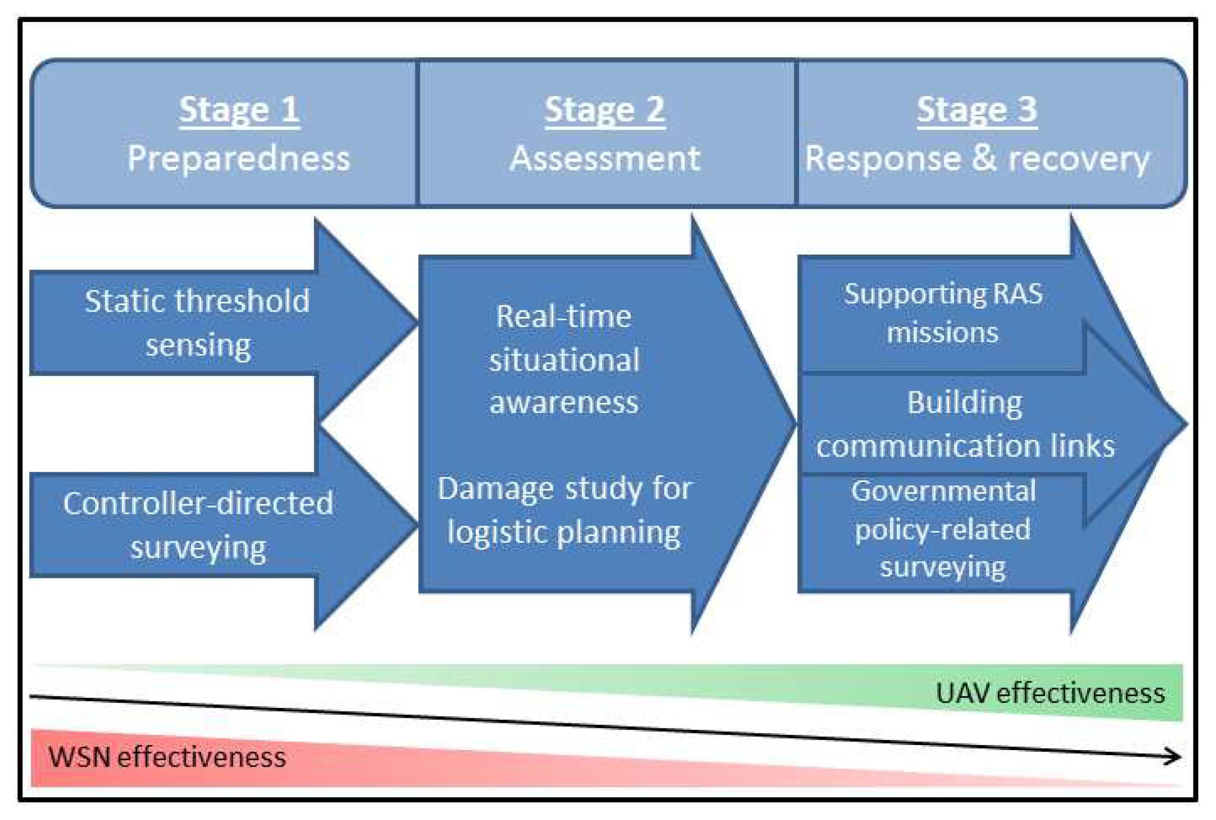
3.2.1. Mission Categories

In the literature (e.g., [105]) 3 categories (stages) of disaster operations are distinguished:
  • Pre-disaster preparedness: pre-empting actions that would cause—or worsen the impact of—a disaster and implement measures to mitigate (or entirely avoid) the impact of an event.
  • Disaster assessment: evaluate the areas impacted by a disaster, assess the extent to which they are affected and aggregate this information into reports.
  • Disaster response and recovery: on the basis of the above, react and respond efficiently.

3.2.2. Application Classes

Above we discuss the advantages of using UAVs as mobile sensor networks in the context of disaster related scenarios (cf. Section 3.1.2). In accordance with the literature (see Figure 3) we argue that the by far biggest advantage of using UAVs (in the context of providing communication or sensing infrastructure) is generated during—or in the aftermath of—a disaster.
The American Red Cross distinguishes four main application classes for the use of UAVs as mobile sensing platforms in disaster assessment and disaster response and recovery missions [104]:
  • Search and Rescue (SR),
  • Reconnaissance and Mapping (RM),
  • Structural Inspection (SI) and
  • Debris Estimation (DE).
Table 2 gives an overview of recent disaster response and recovery operations where UAVs were used and details the type (fixed wing (W) versus rotary (R) UAV, see Section 4.2.1 for a discussion of the relevance of this distinction) and the application area (SR, RM, SI or DE) the UAV was used in.

3.3. Application Types for UAVs during or in the Wake of Disasters

As mentioned in Section 3.2.1, in the field of disaster response and mitigation mission are classified as belonging to one of 3 categories, or stages [105], with a clear temporal ordering: while the first stage is before the event, the latter two stages are happening during and (mainly) after the event has occurred. Since one mayor advantage of UAVs is their mobility and the ability to adapt to changing environments and missions, their use is especially advocated for the periods during and after an event as the preparedness can be addressed by other, more permanent infrastructure and hardware.
Applications for UAVs in the time before a disaster are similar to those discussed for Smart City & Public Safety (cf. Section 2), above. Therefore we focus on applications using UAVs during—or in the immediate aftermath of—a or man-made disaster (or an attack). As before in Section 3.2.2 we distinguish applications by whether they are mainly concerning sensing (such as SR, RM or SI, mentioned above), acting or the delivery of a service (such as RM or DE, above).

3.3.1. Sensing & Monitoring Applications

The vast majority of applications found in the literature are related to sensing, monitoring, data collection and surveillance [48,89]. In this context, 3 sub-categories seem to emerge from the literature:
  • search and rescue (SAR) [104]/wilderness SAR [78] missions, mainly to locate [65,83,88,99] of victims (e.g., after avalanches [85] or flooding [71]) but also to monitor them [83].
  • situational awareness [33,65,81,88,96,97,105], including indoor situational awareness [99], inspection tasks [90], heat source location [96,97,105] and damage assessment [68,81].
  • surveillance [40,48,82,87,90,91,113] and monitoring [74,80,81,82,86,88,113] missions. UAVs are ideal suited for aerial surveillance [53,93] and tracking [78]. They are widely used for structural—monitoring [105] (and —inspection [104]), traffic—monitoring [53,68,78] (and —management [40]), environment monitoring [34,40,53,79,87] (e.g., for terrain [90] and vegetation [68,114] surveying, assessing ice/snow thickness [115] and ecosystem monitoring [68]), hazard monitoring (for e.g., gas [73], radiation [100] but also for wildfires [78] or forrest fires [53]) and weather monitoring [40], specifically atmospheric forecast [79] and wind [116].

3.3.2. Actuation Applications

With regard to actuation applications, participating in logistic operations [33,80,81] such as supply—delivery [34] and —missions [33] are the ones most common applications. UAVs have also been to recover hazardous materials [78] and for the autonomous manipulation of objects [94].

3.3.3. Services

As mentioned, the by far the most common UAV/UAV swarm -based service is to provide communication support [55,58], with the use-case examples ranging from contributing to aerial communication infrastructure [52,53,54,56,59,60,61], over the delivery of broadband wireless connectivity [52,53,55,56,58,59,60,61] and VHF/UHF radio coverage (especially in emergencies scenarios when relatively low-tech approaches are often favored) [92] to forming mobile wireless sensor networks (WSNs) [54,57,92]. In addition, UAVs are often used as mobile sensing platforms for reconnaissance [104] or to assist with infrastructure inspection [85,86,88,101], specifically power lines inspection [91] (cf. Section 3.1.2). They can also be used for patrolling [70,88] and to map an area/for terrain surveying [90,104,105]. UAVs have also been used to protect human resources by employing them to monitor and protect personal [69], to assist with evacuation efforts [73,100] and for humanitarian localization [79]. Notably, a UAV-embedded microphone array was used to facilitate the identification of humans by sound (in case of lack of visual data or when the humans are not in the line of sight) [109]. Furthermore, UAVs have been used for debris estimation [104] and, as mentioned before, generally for missions that required operating in extreme environments [41,89,106,110,111,112].

3.4. Advantages of Using UAVs, Individually or in Swarms

3.4.1. UAVs in General

The following reasons for using drones in disaster scenarios are [104]:
  • UAVs can reduce disaster worker-, claims adjuster-, and risk engineer-exposure to danger.
  • Drones enhance the effectiveness of responders.
  • Drones provide unique viewing angles not possible from manned aircraft.
  • Drone technology is highly deployable.
  • Drone technology is cost-efficient.
Furthermore, UAVs support on-board decision making [66] due to their embedded processing power [91]. Their mobility [61,91], ability to provide real-time data [65] and their lightweight character [91] make them ideal for the monitoring of structures [94]. For example, a UAV-based method for disaster evaluation on the basis of remote image classification in e.g., earthquake and flood scenarios was proposed in [117], a consortium that shared UAV resources and, more importantly, the imagery generated by the UAV is discussed in [68]. Due to their ability to cover different height levels [91] and their imaging capabilities [74,75] they can be used to generate and provide 3D models of areas for SAR missions [65]. UAVs are furthermore expendable (i.e., not humans) [88] and can be equipped with ground penetrating radar [85] or sensors to identify humans by sound [109].

3.4.2. Usage of UAV Swarms in Civil Security and Disaster Response Applications

The use of multiple devices in swarms is increasingly considered, both for homogeneous swarms (consisting only of UAVs) [34,46,55,56,77,87,100,102] as well as for heterogeneous swarms [60,88] (combining UAVs and unmanned ground vehicles (UGVs) or [70,71] (combining UAVs and unmanned surface vehicles (USVs). Specifically, the use of multiple UAVs working together to identify objects of interest (shipwreck survivors, intruders) in water (here: the open sea) using multiple device types (aquatic as well as aerial devices, the former serving as a landing platform/staging location for the latter) is discussed in [70]. Their UAV is capable of landing on water to reduce the operational drain on the battery. Regarding UAV swarms, an approach for optimum hovering locations for multiple drones is offered in [61]. Finally, We refer the reader to [34] for a good survey of UAV-based communication for civil use scenarios, which often requires the cooperation of multiple devices.

4. Application Challenges

UAVs also poses challenges, ranging from ensuring communication with—and between—the devices to enable applications to be implemented in the first place, (Section 4.1) hardware and software choices that can strongly affect performance and applicability (Section 4.2) up to a number of issues faced when operating drones in society and the physical environment (Section 4.3).

4.1. Communication and Communication Infrastructure

We distinguish two main categories of communication challenges: (1) issues relating to the establishing and operating of the underlying communication network [118], including ensuring certain topological properties (e.g., maintaining a fully connected network [119], establishing redundancy [61] and avoiding bottlenecks) and (2) matters related to either the data communicated over such networks [118] or the services provided with them [34] (e.g., broadband wireless connectivity [93], wireless sensor network [57] or providing VHF/UHF radio coverage during emergencies [92]). Communication is an important challenge for UAV swarms; we refer to the surveys [30,34] on UAV-based communication (civil use cases) and [33] on UAV communication networks.

4.1.1. Operating a Communication Infrastructure

Communication is identified as one of the integral basic functionalities of a swarm [12]. Because of their high mobility and capability for rapid deployment [34], UAVs are often proposed as enabler for aerial mobile communication structures. i.e., as supplement to—or even replacement of—existing communication infrastructure in case it has been compromised or entirely wiped out [61].
Communication networks have certain topological requirements (such as e.g., they must be fully connected to the back haul network) and recently a number of creative solutions have been proposed, ranking from Google’s solar power drones that are intended to remain airborne for extended periods of time to e.g., the use of High Altitude Balloons (HAB) to relay data traffic and to boost signals [118].
The deployment and positioning of UAVs to form a cell network [55] and to dynamically adapt its topology to account for link loss and to avoid outages and connectivity problems [119] have been addressed in the literature. Secure communication protocols for inter-UAV as well as UAV-sensor communication is discussed in [64]. Aspects related to operating in the physical environment such as optimizing hovering locations [61] and handling data processing requirements (i.e., operating under computational constraints) through e.g., UAV-Cloud systems [77] have been addressed in the literature. A good survey of important issues in UAV communication networks is offered by [33].

4.1.2. Operating in the Absence of a Communication Infrastructure

A third aspect, previously unmentioned, is the fact that UAVs may have to operate in the absence of—or under the assumption of unreliable or compromised—communication infrastructure. This can be due to the location (indoor [99] or in so-called urban canyons between high rise buildings [50]) disasters (such as e.g., Hurricane Katrina, which lead to the disconnection of 3 million land-line phones and more than 2000 cell sites [55]) or when the infrastructure has been compromised (e.g., [120]). A significant amount of research [7,12,13,14,15,16,17,18,19,121] is now directed at self-organizing formation control and self-assembly methods especially in the absence of global communication.

4.2. Hardware and Software

4.2.1. Device Classes

Above in e.g., Table 2 we followed the US Red Cross [104] and simply distinguished UAVs as being either fixed wing or rotary UAVs. Here we elaborate on this in more detail and consider another distinction within the class of rotary UAVs (cf. Table 3 for a brief overview over these 3).
There are already a large number of diverse devices and different device types commercially available and the difference in price can be substantial between them. Other than the price, application specific requirements determine the suitability of a device/device-type for specific applications. The differences between fixed wing and multicopter UAVs with respect to e.g., their usability and performance for surveillance operations [48,94] indicate that device specifications will determine suitability for specific missions. The—sometime significant—differences in cost makes determining the optimal device and device-type for applications a challenge.

4.2.2. Device Payload and Flight Time

Table 4 illustrates the variations in e.g., payload capacity that the three types of devices can deliver. Next to flight time, maximum payload might be the most crucial aspect when choosing a device type, as e.g., radiation detection and measurement applications might require rather heavy sensing equipment [100], while for e.g., the detection of life signs (such as respiratory motion) in victims of disasters [83] the application relies on device mounted special equipment.
Applications range from localization of avalanche victims using the signals from specialized wireless enabled devices to using UAV-based ground penetrating radar can be used to scan large areas [85] to UAVs that carry the hardware required to enable embedded video processing and data acquisition [75]. Since flight time may depend on the carried fuel or batteries there is a possible trade-off between available payload and maximum air-time.
The examples compiled into Table 4 refer specifically to gas sensing operations. These examples include a solar powered UAV [126] (most drones will require recharging or refueling between missions) a UAV-based CO2 concentrations sensing system [122] with a payload of 3.5 kg, UAV helicopter with a 3 kg payload used to measure gases in extreme conditions (i.e., over volcanoes) [110]. However, these are examples for relatively low requirements: ref [125,127] use a fixed wing UAV with a 3.5 m wingspan and maximum payload of 56 kg while [124] employed a UAV with an even larger wingspan and payloads of up to 40 kg. In the literature, many of the approaches referenced above perform the respective task using only a single UAV and report on the challenge of off-setting the impact caused by the dynamicity (here: wind) of the environment. This further motivates the use of swarms to cover entire areas at the same time, enabling the operator to treat the environment as static.

4.2.3. Sensing Equipment

Above we already mentioned radiation detection [100], ground penetrating radar [85] ultraviolet and infrared spectrometer [110] to measure volcanic gases. Another approaches in the literature report using Global Navigation Satellite System Reflectometry (GNSS-R) [79,128,129], sonar sensors or laser range finders [130], optical and hyper-spectral cameras or Synthetic-Aperture Radar [79]. Often, a variety of different sensors is required to cover all wave lengths of interest. In [131] the author identifies light sensors with sensitivity to various wavelengths in the field of precision agriculture:
  • Visible spectrum imaging,
  • Infrared spectrum imaging [132], and
  • Fluorescence excitation
The more specialized a sensing array is, the more precise applications can be driven by the data generated by it. However, specialized equipment normally comes at a high cost and with limited versatility. Since devices such as sensing arrays and fixed wing UAVs with large payload capacity are expensive and require significant maintenance [79], sharing resource between practitioners, agencies or companies may offer a alternative to otherwise prohibitively large investments by reducing overall cost and increase cost-performance ratio.

4.2.4. Software

Given on-board processing power, UAVs are increasingly able to contribute to problem solving and data processing tasks. This development also continuously makes UAVs potentially more autonomous as algorithms required for e.g., flight path calculations can be born by the devices themselves. In addition, this reduces the requirements placed in the communication infrastructure since less data has to be communicated to a centralized command.
When it comes to the available software, the challenge is either to identify suitable off-the-shelf software or to invest in designing and implementing proprietary solutions, which may require resources and time. However, the literature is teeming with novel approaches, algorithms and software implementations addressing a vast variety of problems. To name just a few: a geometric correction algorithm to reduce image distortion for UAV-based imagery (in disaster scenarios) [74], an algorithm to dynamically adapt the communication network topology to account for link loss and to avoid outages and connectivity problems [119], an image processing algorithm to process imagery provided from sensors mounted on aerial devices [131], an approach for optimum hovering locations for multiple drones [61], an off-line path planning algorithm for heterogeneous UAV swarm-based surveillance scenarios to ensure persistent surveillance [87], and a self-adapting multi-object evolution algorithm facilitating path planning for UAVs [102].

4.3. UAV Operation

Operating UAVs poses a number of challenges as well, such as testing and simulating swarms of UAVs and training operators, which normally require expensive simulators [41] because the conditions under which UAVs operate are different from those of conventional piloted aircraft [93]. However, the environment in which UAVs operate itself poses reason for concern, independent of the environment; operating a large number of devices in the same airspace requires a commonly agreed upon traffic management approach. In addition to these practical operational issues, there are of course other concerns regarding the operation of these devices as well as regarding the use of these devices as sensing devices (i.e., Security and Privacy concerns) [133].

4.3.1. Environmental

Environmental challenges involve weather conditions (rain, wind gusts, humidity, temperature), terrain characteristics (presence of high canopy in the vicinity of the area of interest) etc. [94]. Experiments have shown [134] that the power consumption may depend significantly more on environmental conditions such as side winds than on either the payload or the altitude. High (and changing) winds are likely to be an issue when operating in coastal zones [41]. Operating multiple UAVs in unknown scenarios requires fast and adaptive path planning to avoid collisions and to ensure optimal travel times for the devices. In [102] a self-adapting multi-object evolution algorithm to facilitate UAV path planning is proposed and simultaneous localization and mapping based real-time tracking can be used when GPS signals can not be used reliably or are unavailable [120].
Generally speaking, the choice for device and hardware will be influenced by the environment the device is intended to operate in. The more specialized an application is, the more specialized the operational requirements regarding the environment may get, and it is important to clearly define the specifications of environmental conditions beforehand.

4.3.2. UAV Traffic Management

Currently available off-the-shelf multi-rotor UAVs can remain airborne for approximately 15–20 min before needing to recharge [105], motivating the use of optimization techniques to optimize flight paths. In the context of managing the airspace when large and very large numbers of UAVs are operating in the same theatre, ref [80] investigates platooning for UAV swarms and proposes an approach that can handle massive fleets and handles device malfunctioning or intrusion well. In [135] multiple device types addressing the Travelling Salesman Problem (TSP) in the context of measuring/surveilling an area is considered. In [87] an off-line path planning algorithm for UAV swarms tasked to provide continuous and uninterrupted surveillance coverage over an area is proposed. Another problem class found in the literature is the so-called Watchman Routing Problem (WRP) which is similar to the TSP but considers line of sight visibility [67]. In [136] the Optimal WRP is discussed while [137] considers the WRP under limited visibility. Heuristics to solve such problems (well known to be of high complexity) are needed to increase the efficiency of dispatch and scheduling for UAV swarms.
Finally, if UAVs are to be allowed to operate within urban areas, a city-wide traffic management system has to be created to handle the increasing traffic occupying the same airspace. A cloud-based system for city-wide unmanned air traffic management offering sensor systems to keep the city safe and control systems for collision avoidance is proposed in [101], with the authors arguing that “[…] unmanned aircraft need unmanned air traffic control. Traffic lights for cars are unmanned and low-cost.”.

4.3.3. So-Called Legal Issues

Drones, albeit their almost pervasive presence (it is increasingly difficult to find someone who has not seen a drone operating in the wild), are still somewhat of a revolutionary technology in that their use and availability is spreading considerably faster than awareness about potential concerns or legislative frameworks to address these concerns [78]. For the near future different countries will probably continue to impose different regulations regarding the use of UAVs [105,133], and those regulations may be subject to frequent change and amendment. The use of UAVs in public airspace touches on a number of technical and societal concerns and challenges [62]. Currently, there are not many certainties with regard to the legal regulations for drones since—as it is frequently the case with new technologies—their rapid adoption outpaces legal, policy, and social ability to cope with issues regarding privacy and interference with well-established commercial air space [63]. As mentioned in the next section, cybersecurity, privacy, and public safety concerns need to be addressed [62]. It should be noted though that for applications in the context of emergency or disaster scenarios different regulations may apply to the usage of UAVs [105] and that currently special authorizations are usually granted to flying devices to help first responders. A survey of the main security, privacy, and safety aspects associated with the use of civilian drones in the national airspace is provided by [47].

4.3.4. Privacy and Data Security

With the market for civilian UAVS expanding and the number of devices in operation rapidly increasing poses threats to people, property and privacy rights [47]. In [78] the authors analyse the risk drones can pose for privacy and data protection and [62] surveys aspects of cybersecurity, privacy, and public safety in the context of drones in future smart cities. In [84] the use of UAVs to augment the sensing capability of a smart city is proposed but the authors suggest a data broker to manage the privacy and security issues related to sharing data across subscribers. In addition, as discussed above, the communication of the data has to be protected through secure communication protocols (e.g., the work of [64] to secure communication between drones and smart objects). A survey over the main security, privacy, and safety aspects associated with the use of civilian drones in the national airspace is offered by [47], but as mentioned above, the legal situation is currently changing quickly and for the foreseeable future the literature reviews are expected to be trailing the actual state of affairs.

5. Conclusions

Due to an increase in the availability and diversity of affordable hardware, and the performance of virtually all relevant sub-systems, and due to the massive decrease in cost and difficulty to operate, UAVs are rapidly becoming a common part of a variety of applications. In this article we have briefly discussed our view on three application areas which already have (and will increasingly continue to do so) benefitted from the use of UAVs. We make the distinction between sensing hardware and actuators, both of which can be mounted onto UAVs to become purpose-made/specialized devices. We argue that such mobile sensing/actuation platforms have already matured to the point where they are widely considered as a viable addition to existing application and approaches.
Combining all of the above, what stands between UAVs and the wide-spread use of them is not the lack of application or availability of devices but a number of challenges, identified in Section 4. As we continue to—one by one—overcome these (or continuously improve on our solutions to them), UAVs will probably become a more common sight in every-day life applications as well as constitute an increasingly important role in highly specialized infrastructures. In most cases, the challenges identified have to be addressed not only for individual devices but also for swarms of devices. We believe that with increasing use and availability of UAVs, the emergence of UAV-swarms is inevitable. We furthermore believe that the usefulness of such swarms will dramatically increase with growing autonomy of both the individual swarm member, as well as the entire collective. Our work in the last 5 years has focused on the design of novel (and often nature-inspired [138,139,140,141]) approaches and algorithms to optimize the collective performance of swarms of UAVs (cf. [35,36,37,38,39]). Future work will aim to validate these theoretical results using swarms of at least 3 of the drones shown in Figure 4.
As such, this article is meant to serve as a brief overview over the state of the art, but also to offer an outlook over the things that are yet to come and the challenges that we will face along the way. The interested reader is further referred to the following selected publications which also provide an overview over their respective topics: [7] (from 2017), titled “Bio-inspired self-organising multi-robot pattern formation: A review” (193 references), [8] (from 2018), titled “Decentralized planning and control for UAV–UGV cooperative teams” (53 references) and [48] (from 2018), titled “Cooperative Robots to Observe Moving Targets: Review” (110 references). This list is, of course, not comprehensive.
With regard to an extensive overview over civil applications for UAVs in general we refer the reader to [10] (from 2019), titled “Unmanned Aerial Vehicles (UAVs): A Survey on Civil Applications and Key Research Challenges” (366 references). Finally, we recommend to keep an eye on the web page of this journal (MDPI Drones) where new publications are continuously made available for download.

Funding

This research received no external funding.

Conflicts of Interest

The authors declare no conflict of interest.

Abbreviations

The following abbreviations are used in this manuscript:
CAGRCompound Annual Growth Rate
DEDebris Estimation
GNSS-RGlobal Navigation Satellite System Reflectometry
HABHigh Altitude Balloons
IASIntelligent Autonomous Systems
IoTInternet of Things
MSPMobile Sensing Platform
NECNEC Corporation, formerly Nippon Electric Company, Limited
NLENEC research Labs, Europe
RMReconnaissance and Mapping
ROARemotely Operated Aircrafts
RPARemotely Piloted Aircrafts
SIStructural Inspection
SRSearch and Rescue
SARSearch and Rescue
TNODutch Organisation for Applied Scientific Research
TSPTravelling Salesman Problem
UASUnmanned Aerial Systems
UAVUnmanned Aerial Vehicles
USVUnmanned Surface Vehicles
UGVUnmanned Ground Vehicle
UHFUltra High Frequency
VHFVery High Frequency
WSNWireless Sensor Networks

References

  1. Schneider, D. Open season on drones? IEEE Spectr. 2014, 51, 32–33. [Google Scholar] [CrossRef]
  2. Coopmans, C. Architecture requirements for Ethical, accurate, and resilient Unmanned Aerial Personal Remote Sensing. In Proceedings of the 2014 International Conference on Unmanned Aircraft Systems (ICUAS), Orlando, FL, USA, 27–30 May 2014; pp. 1–8. [Google Scholar] [CrossRef]
  3. Marcus, M. Spectrum policy challenges of UAV/drones [Spectrum Policy and Regulatory Issues]. IEEE Wirel. Commun. 2014, 21, 8–9. [Google Scholar] [CrossRef]
  4. Ogan, R. Integration of manned and unmanned aircraft systems into U.S. airspace. In Proceedings of the IEEE SOUTHEASTCON 2014, Lexington, KY, USA, 13–16 March 2014; pp. 1–4. [Google Scholar] [CrossRef]
  5. Broad, W.J. The U.S. Flight from Pilotless Planes. Science 1981, 213, 188–190. [Google Scholar] [CrossRef] [PubMed]
  6. Conesa-Muñoz, J.; Valente, J.; Del Cerro, J.; Barrientos, A.; Ribeiro, A. A Multi-Robot Sense-Act Approach to Lead to a Proper Acting in Environmental Incidents. Sensors 2016, 16, 1269. [Google Scholar] [CrossRef] [PubMed]
  7. Oh, H.; Shirazi, A.R.; Sun, C.; Jin, Y. Bio-inspired self-organising multi-robot pattern formation: A review. Robot. Auton. Syst. 2017, 91, 83–100. [Google Scholar] [CrossRef]
  8. Arbanas, B.; Ivanovic, A.; Car, M.; Orsag, M.; Petrovic, T.; Bogdan, S. Decentralized planning and control for UAV–UGV cooperative teams. Auton. Robots 2018, 42, 1601–1618. [Google Scholar] [CrossRef]
  9. Schlotfeldt, B.; Thakur, D.; Atanasov, N.; Kumar, V.; Pappas, G.J. Anytime Planning for Decentralized Multirobot Active Information Gathering. IEEE Robot. Autom. Lett. 2018, 3, 1025–1032. [Google Scholar] [CrossRef]
  10. Shakhatreh, H.; Sawalmeh, A.H.; Al-Fuqaha, A.I.; Dou, Z.; Almaita, E.K.; Khalil, I.M.; Othman, N.S.; Khreishah, A.; Guizani, M. Unmanned Aerial Vehicles (UAVs): A Survey on Civil Applications and Key Research Challenges. IEEE Access 2019, 7, 48572–48634. [Google Scholar] [CrossRef]
  11. Patil, M.; Abukhalil, T.; Sobh, T. Hardware Architecture Review of Swarm Robotics System: Self-Reconfigurability, Self-Reassembly, and Self-Replication. ISRN Robot. 2013, 2013, 11. [Google Scholar] [CrossRef]
  12. Spezzano, G. Editorial: Special Issue “Swarm Robotics”. Appl. Sci. 2019, 9, 1474. [Google Scholar] [CrossRef]
  13. Yang, J.; Wang, X.; Bauer, P. V-Shaped Formation Control for Robotic Swarms Constrained by Field of View. Appl. Sci. 2018, 8, 2120. [Google Scholar] [CrossRef]
  14. Liu, Y.; Gao, J.; Shi, X.; Jiang, C. Decentralization of Virtual Linkage in Formation Control of Multi-Agents via Consensus Strategies. Appl. Sci. 2018, 8, 2020. [Google Scholar] [CrossRef]
  15. Liu, Y.; Gao, J.; Liu, C.; Zhao, F.; Zhao, J. Reconfigurable Formation Control of Multi-Agents Using Virtual Linkage Approach. Appl. Sci. 2018, 8, 1109. [Google Scholar] [CrossRef]
  16. Tan, W.; Wei, H.; Yang, B. SambotII: A New Self-Assembly Modular Robot Platform Based on Sambot. Appl. Sci. 2018, 8, 1719. [Google Scholar] [CrossRef]
  17. Qian, D.; Xi, Y. Leader–Follower Formation Maneuvers for Multi-Robot Systems via Derivative and Integral Terminal Sliding Mode. Appl. Sci. 2018, 8, 1045. [Google Scholar] [CrossRef]
  18. Nishikawa, N.; Suzuki, R.; Arita, T. Exploration of Swarm Dynamics Emerging from Asymmetry. Appl. Sci. 2018, 8, 729. [Google Scholar] [CrossRef]
  19. Garcia-Aunon, P.; Barrientos Cruz, A. Comparison of Heuristic Algorithms in Discrete Search and Surveillance Tasks Using Aerial Swarms. Appl. Sci. 2018, 8, 711. [Google Scholar] [CrossRef]
  20. Wang, W.; Bai, P.; Li, H.; Liang, X. Optimal Configuration and Path Planning for UAV Swarms Using a Novel Localization Approach. Appl. Sci. 2018, 8, 1001. [Google Scholar] [CrossRef]
  21. Pan, L.; Lu, Q.; Yin, K.; Zhang, B. Signal Source Localization of Multiple Robots Using an Event-Triggered Communication Scheme. Appl. Sci. 2018, 8, 977. [Google Scholar] [CrossRef]
  22. Lee, K.B.; Kim, Y.J.; Hong, Y.D. Real-Time Swarm Search Method for Real-World Quadcopter Drones. Appl. Sci. 2018, 8, 1169. [Google Scholar] [CrossRef]
  23. Ge, H.; Chen, G.; Xu, G. Multi-AUV Cooperative Target Hunting Based on Improved Potential Field in a Surface-Water Environment. Appl. Sci. 2018, 8, 973. [Google Scholar] [CrossRef]
  24. Jin, X.; Kim, J. 3D Model Identification Using Weighted Implicit Shape Representation and Panoramic View. Appl. Sci. 2017, 7, 764. [Google Scholar] [CrossRef]
  25. Cheng, L.; Wu, X.H.; Wang, Y. Artificial Flora (AF) Optimization Algorithm. Appl. Sci. 2018, 8, 329. [Google Scholar] [CrossRef]
  26. Połap, D.; Kȩsik, K.; Woźniak, M.; Damaševičius, R. Parallel Technique for the Metaheuristic Algorithms Using Devoted Local Search and Manipulating the Solutions Space. Appl. Sci. 2018, 8, 293. [Google Scholar] [CrossRef]
  27. Wang, H.; Li, Y.; Chang, T.; Chang, S.; Fan, Y. Event-Driven Sensor Deployment in an Underwater Environment Using a Distributed Hybrid Fish Swarm Optimization Algorithm. Appl. Sci. 2018, 8, 1638. [Google Scholar] [CrossRef]
  28. Gainer, J.J., Jr.; Dawkins, J.J.; DeVries, L.D.; Kutzer, M.D.M. Persistent Multi-Agent Search and Tracking with Flight Endurance Constraints. Robotics 2018, 8, 2. [Google Scholar] [CrossRef]
  29. Khuwaja, A.A.; Chen, Y.; Zhao, N.; Alouini, M.; Dobbins, P. A Survey of Channel Modeling for UAV Communications. IEEE Commun. Surv. Tutor. 2018, 20, 2804–2821. [Google Scholar] [CrossRef] [Green Version]
  30. Khawaja, W.; Guvenc, I.; Matolak, D.W.; Fiebig, U.; Schneckenberger, N. A Survey of Air-to-Ground Propagation Channel Modeling for Unmanned Aerial Vehicles. IEEE Commun. Surv. Tutor. 2019. [Google Scholar] [CrossRef]
  31. Mozaffari, M.; Saad, W.; Bennis, M.; Nam, Y.; Debbah, M. A Tutorial on UAVs for Wireless Networks: Applications, Challenges, and Open Problems. IEEE Commun. Surv. Tutor. 2019. [Google Scholar] [CrossRef]
  32. Motlagh, N.H.; Taleb, T.; Arouk, O. Low-Altitude Unmanned Aerial Vehicles-Based Internet of Things Services: Comprehensive Survey and Future Perspectives. IEEE Internet Things J. 2016, 3, 899–922. [Google Scholar] [CrossRef]
  33. Gupta, L.; Jain, R.; Vaszkun, G. Survey of Important Issues in UAV Communication Networks. IEEE Commun. Surv. Tutor. 2016, 18, 1123–1152. [Google Scholar] [CrossRef]
  34. Hayat, S.; Yanmaz, E.; Muzaffar, R. Survey on Unmanned Aerial Vehicle Networks for Civil Applications: A Communications Viewpoint. IEEE Commun. Surv. Tutor. 2016, 18, 2624–2661. [Google Scholar] [CrossRef]
  35. Hildmann, H.; Kovacs, E. “Should I stay or should I go?”—Enabling autonomous mobile devices to optimize data collection performance. In RoboCity 2016—Robots for Citizens; Open Conference on Future Trends in Robotics; AFERTA SG S.L.: Madrid, Spain, 2016; Chapter 31. [Google Scholar]
  36. Almeida, M.; Hildmann, H. A development platform for the evaluation and validation of algorithms for self-organization in hybrid swarms. In RoboCity 2016—Robots for Citizens; Open Conference on Future Trends in Robotics; AFERTA SG S.L.: Madrid, Spain, 2016; Chapter 33. [Google Scholar]
  37. Hildmann, H.; Martin, M. Adaptive scheduling in dynamic environments. In Proceedings of the 2014 Federated Conference on Computer Science and Information Systems (FedCSIS), Warsaw, Poland, 7–10 September 2014; pp. 1331–1336. [Google Scholar]
  38. Hildmann, H.; Martin, M. Resource Allocation and Scheduling based on Emergent behaviours in Multi-Agent Scenarios. In Proceedings of the International Conference on Operations Research and Enterprise Systems, Lisbon, Portugal, 10–12 January 2015; pp. 140–147. [Google Scholar]
  39. Almeida, M.; Hildmann, H. Distributed UAV-swarm-based real-time geomatic data collection under dynamically changing resolution requirements. In Proceedings of the UAV-g 2017—International Conference on Unmanned Aerial Vehicles in Geomatics, in ISPRS Archives of the Photogrammetry, Remote Sensing and Spatial Information Sciences, Bonn, Germany, 4–7 September 2017. [Google Scholar]
  40. Giyenko, A.; Cho, Y.I. Intelligent Unmanned Aerial Vehicle Platform for Smart Cities. In Proceedings of the 2016 Joint 8th International Conference on Soft Computing and Intelligent Systems (SCIS) and 17th International Symposium on Advanced Intelligent Systems (ISIS), Sapporo, Japan, 25–28 August 2016; pp. 729–733. [Google Scholar] [CrossRef]
  41. Rodríguez-Fernández, V.; Menéndez, H.D.; Camacho, D. Design and development of a lightweight multi-UAV simulator. In Proceedings of the 2015 IEEE 2nd International Conference on Cybernetics (CYBCONF), Gdynia, Poland, 24–26 June 2015; pp. 255–260. [Google Scholar] [CrossRef]
  42. Naphade, M.; Banavar, G.; Harrison, C.; Paraszczak, J.; Morris, R. Smarter Cities and Their Innovation Challenges. Computer 2011, 44, 32–39. [Google Scholar] [CrossRef]
  43. Yinbiao, S.; Lee, K.; Lanctot, P.; Jianbin, F.; Hao, H.; Chow, B.; Desbenoit, J.P.; Stephan, G.; Hui, L.; Guodong, X.; et al. Internet of Things: Wireless Sensor Networks; White Paper; International Electrotechnical Commission: Geneva, Switzerland, 2014. [Google Scholar]
  44. Erol-Kantarci, M.; Mouftah, H. Wireless Sensor Networks for Cost-Efficient Residential Energy Management in the Smart Grid. IEEE Trans. Smart Grid 2011, 2, 314–325. [Google Scholar] [CrossRef]
  45. Yu, R.; Watteyne, T. Reliable, Low Power Wireless Sensor Networks for the Internet of Things: Making Wireless Sensors as Accessible as Web Servers; White Paper; Linear Technology: Milpitas, CA, USA, 2013. [Google Scholar]
  46. Giyenko, A.; Cho, Y.I. Intelligent UAV in smart cities using IoT. In Proceedings of the 2016 16th International Conference on Control, Automation and Systems (ICCAS), Gyeongju, Korea, 16–19 October 2016; pp. 207–210. [Google Scholar] [CrossRef]
  47. Altawy, R.; Youssef, A.M. Security, Privacy, and Safety Aspects of Civilian Drones: A Survey. ACM Trans. Cyber-Phys. Syst. 2016, 1, 7. [Google Scholar] [CrossRef]
  48. Khan, A.; Rinner, B.; Cavallaro, A. Cooperative Robots to Observe Moving Targets: Review. IEEE Trans. Cybern. 2018, 48, 187–198. [Google Scholar] [CrossRef] [PubMed]
  49. Meng, X.; Wang, W.; Leong, B. SkyStitch: A Cooperative Multi-UAV-based Real-time Video Surveillance System with Stitching. In Proceedings of the 23rd ACM International Conference on Multimedia, Brisbane, Australia, 26–30 October 2015; pp. 261–270. [Google Scholar] [CrossRef]
  50. Semsch, E.; Jakob, M.; Pavlicek, D.; Pechoucek, M. Autonomous UAV Surveillance in Complex Urban Environments. In Proceedings of the 2009 IEEE/WIC/ACM International Joint Conference on Web Intelligence and Intelligent Agent Technology, Milan, Italy, 15–18 September 2009; pp. 82–85. [Google Scholar] [CrossRef]
  51. Mohammed, F.; Idries, A.; Mohamed, N.; Al-Jaroodi, J.; Jawhar, I. UAVs for smart cities: Opportunities and challenges. In Proceedings of the 2014 International Conference on Unmanned Aircraft Systems (ICUAS), Orlando, FL, USA, 27–30 May 2014; pp. 267–273. [Google Scholar] [CrossRef]
  52. Hayajneh, A.M.; Zaidi, S.A.R.; McLernon, D.C.; Ghogho, M. Drone Empowered Small Cellular Disaster Recovery Networks for Resilient Smart Cities. In Proceedings of the 2016 IEEE International Conference on Sensing, Communication and Networking (SECON Workshops), London, UK, 27 June 2016; pp. 1–6. [Google Scholar] [CrossRef]
  53. Madany, Y.M.; Elkamchouchi, H.M.; Ahmed, M.M. Modelling and Simulation of Robust Navigation for Unmanned Air Systems (UASs) Based on Integration of Multiple Sensors Fusion Architecture. In Proceedings of the 2013 European Modelling Symposium, Manchester, UK, 20–22 November 2013; pp. 719–724. [Google Scholar] [CrossRef]
  54. Faiçal, B.S.; Pessin, G.; Filho, G.P.R.; Carvalho, A.C.; Furquim, G.; Ueyama, J. Fine-Tuning of UAV Control Rules for Spraying Pesticides on Crop Fields. In Proceedings of the 2014 IEEE 26th International Conference on Tools with Artificial Intelligence, Limassol, Cyprus, 10–12 November 2014; pp. 527–533. [Google Scholar] [CrossRef]
  55. Bupe, P.; Haddad, R.; Rios-Gutierrez, F. Relief and emergency communication network based on an autonomous decentralized UAV clustering network. In Proceedings of the SoutheastCon 2015, Fort Lauderdale, FL, USA, 9–12 April 2015; pp. 1–8. [Google Scholar] [CrossRef]
  56. Giagkos, A.; Wilson, M.S.; Tuci, E.; Charlesworth, P.B. Comparing approaches for coordination of autonomous communications UAVs. In Proceedings of the 2016 International Conference on Unmanned Aircraft Systems (ICUAS), Arlington, VA, USA, 7–10 June 2016; pp. 1131–1139. [Google Scholar] [CrossRef]
  57. Giannini, C.; Shaaban, A.A.; Buratti, C.; Verdone, R. Delay Tolerant Networking for smart city through drones. In Proceedings of the 2016 International Symposium on Wireless Communication Systems (ISWCS), Poznan, Poland, 20–23 September 2016; pp. 603–607. [Google Scholar] [CrossRef]
  58. Guevara, K.; Rodriguez, M.; Gallo, N.; Velasco, G.; Vasudeva, K.; Guvenc, I. UAV-based GSM network for public safety communications. In Proceedings of the SoutheastCon 2015, Fort Lauderdale, FL, USA, 9–12 April 2015; pp. 1–2. [Google Scholar] [CrossRef]
  59. Kobayashi, T.; Matsuoka, H.; Betsumiya, S. Flying Communication Server in case of a Largescale Disaster. In Proceedings of the 2016 IEEE 40th Annual Computer Software and Applications Conference (COMPSAC), Atlanta, GA, USA, 10–14 June 2016; Volume 2, pp. 571–576. [Google Scholar] [CrossRef]
  60. Mase, K.; Okada, H. Message communication system using unmanned aerial vehicles under large-scale disaster environments. In Proceedings of the 2015 IEEE 26th Annual International Symposium on Personal, Indoor, and Mobile Radio Communications (PIMRC), Hong Kong, China, 30 August–2 September 2015; pp. 2171–2176. [Google Scholar] [CrossRef]
  61. Rupasinghe, N.; Ibrahim, A.S.; Guvenc, I. Optimum Hovering Locations with Angular Domain User Separation for Cooperative UAV Networks. In Proceedings of the 2016 IEEE Global Communications Conference (GLOBECOM), Washington, DC, USA, 4–8 December 2016; pp. 1–6. [Google Scholar] [CrossRef]
  62. Vattapparamban, E.; Güvenç, İ.; Yurekli, A.İ.; Akkaya, K.; Uluağaç, S. Drones for smart cities: Issues in cybersecurity, privacy, and public safety. In Proceedings of the 2016 International Wireless Communications and Mobile Computing Conference (IWCMC), Paphos, Cyprus, 5–9 September 2016; pp. 216–221. [Google Scholar] [CrossRef]
  63. Sterbenz, J.P. Drones in the Smart City and IoT: Protocols, Resilience, Benefits, and Risks. In Proceedings of the 2nd Workshop on Micro Aerial Vehicle Networks, Systems, and Applications for Civilian Use, Singapore, 26 June 2016; p. 3. [Google Scholar] [CrossRef]
  64. Won, J.; Seo, S.H.; Bertino, E. A Secure Communication Protocol for Drones and Smart Objects. In Proceedings of the 10th ACM Symposium on Information, Computer and Communications Security, Singapore, 14–17 April 2015; pp. 249–260. [Google Scholar] [CrossRef]
  65. Verykokou, S.; Doulamis, A.; Athanasiou, G.; Ioannidis, C.; Amditis, A. UAV-based 3D modelling of disaster scenes for Urban Search and Rescue. In Proceedings of the 2016 IEEE International Conference on Imaging Systems and Techniques (IST), Chania, Greece, 4–6 October 2016; pp. 106–111. [Google Scholar] [CrossRef]
  66. Choi, H.; Geeves, M.; Alsalam, B.; Gonzalez, F. Open source computer-vision based guidance system for UAVs on-board decision making. In Proceedings of the 2016 IEEE Aerospace Conference, Big Sky, MT, USA, 5–12 March 2016; pp. 1–5. [Google Scholar] [CrossRef]
  67. Govindaraju, V.; Leng, G.; Qian, Z. Visibility-based UAV path planning for surveillance in cluttered environments. In Proceedings of the 2014 IEEE International Symposium on Safety, Security, and Rescue Robotics (2014), Hokkaido, Japan, 27–30 October 2014; pp. 1–6. [Google Scholar] [CrossRef]
  68. Ezequiel, C.A.F.; Cua, M.; Libatique, N.C.; Tangonan, G.L.; Alampay, R.; Labuguen, R.T.; Favila, C.M.; Honrado, J.L.E.; Caños, V.; Devaney, C.; et al. UAV aerial imaging applications for post-disaster assessment, environmental management and infrastructure development. In Proceedings of the 2014 International Conference on Unmanned Aircraft Systems (ICUAS), Orlando, FL, USA, 27–30 May 2014; pp. 274–283. [Google Scholar] [CrossRef]
  69. Inata, H.; Say, S.; Ando, T.; Liu, J.; Shimamoto, S. Unmanned aerial vehicle based missing people detection system employing phased array antenna. In Proceedings of the 2016 IEEE Wireless Communications and Networking Conference, Doha, Qatar, 3–6 April 2016; pp. 1–6. [Google Scholar] [CrossRef]
  70. Mendonça, R.; Marques, M.M.; Marques, F.; Lourenço, A.; Pinto, E.; Santana, P.; Coito, F.; Lobo, V.; Barata, J. A cooperative multi-robot team for the surveillance of shipwreck survivors at sea. In Proceedings of the OCEANS 2016 MTS/IEEE Monterey, Monterey, CA, USA, 19–23 September 2016; pp. 1–6. [Google Scholar] [CrossRef]
  71. Zhang, J.; Xiong, J.; Zhang, G.; Gu, F.; He, Y. Flooding disaster oriented USV UAV system development demonstration. In Proceedings of the OCEANS 2016, Shanghai, China, 10–13 April 2016; pp. 1–4. [Google Scholar] [CrossRef]
  72. Valente, J.; Almeida, R.A.L. A Comprehensive Study of the Potential Application of Flying Ethylene-Sensitive Sensors for Ripeness Detection in Apple Orchards. Sensors 2019, 19, 372. [Google Scholar] [CrossRef] [PubMed]
  73. Xiong, M.; Zeng, D.; Yao, H.; Li, Y. A Crowd Simulation Based UAV Control Architecture for Industrial Disaster Evacuation. In Proceedings of the 2016 IEEE 83rd Vehicular Technology Conference (VTC Spring), Nanjing, China, 15–18 May 2016; pp. 1–5. [Google Scholar] [CrossRef]
  74. Li, Y.; He, L.; Ye, X.; Guo, D. Geometric correction algorithm of UAV remote sensing image for the emergency disaster. In Proceedings of the IEEE International Geoscience and Remote Sensing Symposium (IGARSS), Beijing, China, 10–15 July 2016; pp. 6691–6694. [Google Scholar] [CrossRef]
  75. Mhatre, V.; Chavan, S.; Samuel, A.; Patil, A.; Chittimilla, A.; Kumar, N. Embedded video processing and data acquisition for unmanned aerial vehicle. In Proceedings of the 2015 International Conference on Computers, Communications, and Systems (ICCCS), Kanyakumari, India, 2–3 November 2015; pp. 141–145. [Google Scholar] [CrossRef]
  76. Skinnemoen, H. UAV amp; satellite communications live mission-critical visual data. In Proceedings of the 2014 IEEE International Conference on Aerospace Electronics and Remote Sensing Technology, Yogyakarta, Indonesia, 13–14 November 2014; pp. 12–19. [Google Scholar] [CrossRef]
  77. Luo, C.; Nightingale, J.; Asemota, E.; Grecos, C. A UAV-Cloud System for Disaster Sensing Applications. In Proceedings of the 2015 IEEE 81st Vehicular Technology Conference (VTC Spring), Glasgow, UK, 11–14 May 2015; pp. 1–5. [Google Scholar] [CrossRef]
  78. Pauner, C.; Kamara, I.; Viguri, J. Drones. Current challenges and standardisation solutions in the field of privacy and data protection. In Proceedings of the 2015 ITU Kaleidoscope: Trust in the Information Society (K-2015), Barcelona, Spain, 9–11 December 2015; pp. 1–7. [Google Scholar] [CrossRef]
  79. Gamba, M.T.; Ugazio, S.; Marucco, G.; Pini, M.; Presti, L.L. Light weight GNSS-based passive radar for remote sensing UAV applications. In Proceedings of the 2015 IEEE 1st International Forum on Research and Technologies for Society and Industry Leveraging a better tomorrow (RTSI), Turin, Italy, 16–18 September 2015; pp. 341–348. [Google Scholar] [CrossRef]
  80. Chen, M.; Hu, Q.; Mackin, C.; Fisac, J.F.; Tomlin, C.J. Safe platooning of unmanned aerial vehicles via reachability. In Proceedings of the 2015 54th IEEE Conference on Decision and Control (CDC), Osaka, Japan, 15–18 December 2015; pp. 4695–4701. [Google Scholar] [CrossRef]
  81. Erdelj, M.; Natalizio, E. UAV-assisted disaster management: Applications and open issues. In Proceedings of the 2016 International Conference on Computing, Networking and Communications (ICNC), Kauai, HI, USA, 15–18 Febuary 2016; pp. 1–5. [Google Scholar] [CrossRef]
  82. Saponara, S.; Neri, B. Radar sensor signal acquisition and 3D FFT processing for smart mobility surveillance systems. In Proceedings of the 2016 IEEE Sensors Applications Symposium (SAS), Catania, Italy, 20–22 April 2016; pp. 1–6. [Google Scholar] [CrossRef]
  83. Nakata, R.; Clemens, S.; Lee, A.; Lubecke, V. RF techniques for motion compensation of an Unmanned Aerial Vehicle for remote radar life sensing. In Proceedings of the 2016 IEEE MTT-S International Microwave Symposium, San Francisco, CA, USA, 22–27 May 2016; pp. 1–4. [Google Scholar] [CrossRef]
  84. Shariat, A.; Tizghadam, A.; Leon-Garcia, A. An ICN-based publish-subscribe platform to deliver UAV service in smart cities. In Proceedings of the 2016 IEEE Conference on Computer Communications Workshops (INFOCOM WKSHPS), San Francisco, CA, USA, 10–14 April 2016; pp. 698–703. [Google Scholar] [CrossRef]
  85. Bejiga, M.B.; Zeggada, A.; Melgani, F. Convolutional neural networks for near real-time object detection from UAV imagery in avalanche search and rescue operations. In Proceedings of the 2016 IEEE International Geoscience and Remote Sensing Symposium (IGARSS), Beijing, China, 10–15 July 2016; pp. 693–696. [Google Scholar] [CrossRef]
  86. Zhang, Y.; Ren, Z.; Liu, L.; Wei, C.; Yin, C. Design for a fast high precision UAV power emergency relief system. In Proceedings of the 4th Int. Conf. on Applied Robotics for the Power Industry (CARPI), Jinan, China, 11–13 October 2016; pp. 1–4. [Google Scholar] [CrossRef]
  87. Scherer, J.; Rinner, B. Persistent multi-UAV surveillance with energy and communication constraints. In Proceedings of the 2016 IEEE International Conference on Automation Science and Engineering (CASE), Fort Worth, TX, USA, 21–25 August 2016; pp. 1225–1230. [Google Scholar] [CrossRef]
  88. Reardon, C.; Fink, J. Air-ground robot team surveillance of complex 3D environments. In Proceedings of the 2016 IEEE International Symposium on Safety, Security, and Rescue Robotics (SSRR), Lausanne, Switzerland, 23–27 October 2016; pp. 320–327. [Google Scholar] [CrossRef]
  89. Reyad, M.; Arafa, M.; Sallam, E.A. An optimal PID controller for a qaudrotor system based on DE algorithm. In Proceedings of the 2016 11th International Conference on Computer Engineering Systems (ICCES), Cairo, Egypt, 20–21 December 2016; pp. 444–451. [Google Scholar] [CrossRef]
  90. Vasquez-Gomez, J.I.; Gomez-Castañeda, C.; Cote, E.M.D.; Herrera-Lozada, J.C. Multirotor UAV Coverage Planning under Wind Conditions. In Proceedings of the 2016 International Conference on Mechatronics, Electronics and Automotive Engineering (ICMEAE), Cuernavaca, Mexico, 22–25 November 2016; pp. 32–37. [Google Scholar] [CrossRef]
  91. Montanari, R.; Tozadore, D.C.; Fraccaroli, E.S.; Romero, R.A.F. Ground Vehicle Detection and Classification by an Unmanned Aerial Vehicle. In Proceedings of the 2015 12th Latin American Robotics Symposium and 2015 3rd Brazilian Symposium on Robotics (LARS-SBR), Uberlandia, Brazil, 29–31 October 2015; pp. 253–258. [Google Scholar] [CrossRef]
  92. De Albuquerque, J.C.; de Lucena, S.C.; Campos, C.A.V. Evaluating data communications in disaster scenarios using opportunistic networks with Unmanned Aerial Vehicles. In Proceedings of the 2016 IEEE 19th International Conference on Intelligent Transportation Systems (ITSC), Rio de Janeiro, Brazil, 1–4 November 2016; pp. 1452–1457. [Google Scholar] [CrossRef]
  93. Khawaja, W.; Guvenc, I.; Matolak, D. UWB Channel Sounding and Modeling for UAV Air-to-Ground Propagation Channels. In Proceedings of the 2016 IEEE Global Communications Conference (GLOBECOM), Washington, DC, USA, 4–8 December 2016; pp. 1–7. [Google Scholar] [CrossRef]
  94. Mora, A.; Vemprala, S.; Carrio, A.; Saripalli, S. Flight performance assessment of land surveying trajectories for multiple UAV platforms. In Proceedings of the 2015 Workshop on Research, Education and Development of Unmanned Aerial Systems (RED-UAS), Cancun, Mexico, 23–25 November 2015; pp. 1–7. [Google Scholar] [CrossRef]
  95. Nugroho, G.; Satrio, M.; Rafsanjani, A.A.; Sadewo, R.R.T. Avionic system design Unmanned Aerial Vehicle for disaster area monitoring. In Proceedings of the 2015 International Conference on Advanced Mechatronics, Intelligent Manufacture, and Industrial Automation (ICAMIMIA), Surabaya, Indonesia, 15–17 October 2015; pp. 198–201. [Google Scholar] [CrossRef]
  96. Cook, Z.; Zhao, L.; Lee, J.; Yim, W. Unmanned aerial vehicle for hot-spot avoidance with stereo FLIR cameras. In Proceedings of the 12th Int. Conf. on Ubiquitous Robots and Ambient Intelligence, Goyang, Korea, 28–30 October 2015; pp. 318–319. [Google Scholar] [CrossRef]
  97. Cook, Z.; Zhao, L.; Lee, J.; Yim, W. Unmanned aerial system for first responders. In Proceedings of the 12th Int. Conf. on Ubiquitous Robots and Ambient Intelligence, Goyang, Korea, 28–30 October 2015; pp. 306–310. [Google Scholar] [CrossRef]
  98. Valente, J.; Sanz, D.; Barrientos, A.; del Cerro, J.; Ribeiro, A.; Rossi, C. An Air-Ground Wireless Sensor Network for Crop Monitoring. Sensors 2011, 11, 6088–6108. [Google Scholar] [CrossRef] [Green Version]
  99. Lee, K.S.; Ovinis, M.; Nagarajan, T.; Seulin, R.; Morel, O. Autonomous patrol and surveillance system using unmanned aerial vehicles. In Proceedings of the 2015 IEEE 15th International Conference on Environment and Electrical Engineering (EEEIC), Rome, Italy, 10–13 June 2015; pp. 1291–1297. [Google Scholar] [CrossRef]
  100. Cai, C.; Carter, B.; Srivastava, M.; Tsung, J.; Vahedi-Faridi, J.; Wiley, C. Designing a radiation sensing UAV system. In Proceedings of the 2016 IEEE Systems and Information Engineering Design Symposium (SIEDS), Charlottesville, VA, USA, 29 April 2016; pp. 165–169. [Google Scholar] [CrossRef]
  101. Foina, A.G.; Sengupta, R.; Lerchi, P.; Liu, Z.; Krainer, C. Drones in smart cities: Overcoming barriers through air traffic control research. In Proceedings of the 2015 Workshop on Research, Education and Development of Unmanned Aerial Systems (RED-UAS), Cancun, Mexico, 23–25 November 2015; pp. 351–359. [Google Scholar] [CrossRef]
  102. Liu, Y.; Lv, R.; Guan, X.; Zeng, J. Path planning for unmanned aerial vehicle under geo-fencing and minimum safe separation constraints. In Proceedings of the World Congress on Int. Control and Automation, Guilin, China, 12–15 June 2016; pp. 28–31. [Google Scholar] [CrossRef]
  103. Borreguero, D.; Velasco, O.; Valente, J. Experimental Design of a Mobile Landing Platform to Assist Aerial Surveys in Fluvial Environments. Appl. Sci. 2018, 9, 38. [Google Scholar] [CrossRef]
  104. Cross, A.R. Drones for Disaster Response and Relief Operations. Report; Measure (32 Advisors Company). 2015. Available online: www.issuelab.org/resources/21683/21683.pdf (accessed on 24 July 2019).
  105. Erdelj, M.; Natalizio, E.; Chowdhury, K.R.; Akyildiz, I.F. Help from the Sky: Leveraging UAVs for Disaster Management. IEEE Pervasive Comput. 2017, 16, 24–32. [Google Scholar] [CrossRef]
  106. Rokhmana, C.A.; Andaru, R. Utilizing UAV-based mapping in post disaster volcano eruption. In Proceedings of the 2016 6th International Annual Engineering Seminar (InAES), Yogyakarta, Indonesia, 1–3 August 2016; pp. 202–205. [Google Scholar] [CrossRef]
  107. McNutt, M. Preparing for the next Katrina. Science 2015, 349, 905. [Google Scholar] [CrossRef]
  108. Plag, H.P. Foreword: Extreme geohazards—A growing threat for a globally interconnected civilization. Nat. Hazards 2014, 72, 1275–1277. [Google Scholar] [CrossRef]
  109. Morito, T.; Sugiyama, O.; Kojima, R.; Nakadai, K. Partially Shared Deep Neural Network in sound source separation and identification using a UAV-embedded microphone array. In Proceedings of the 2016 IEEE/RSJ International Conference on Intelligent Robots and Systems (IROS), Daejeon, Korea, 9–14 October 2016; pp. 1299–1304. [Google Scholar] [CrossRef]
  110. McGonigle, A.J.S.; Aiuppa, A.; Giudice, G.; Tamburello, G.; Hodson, A.J.; Gurrieri, S. Unmanned aerial vehicle measurements of volcanic carbon dioxide fluxes. Geophys. Res. Lett. 2008, 35, L06303. [Google Scholar] [CrossRef]
  111. Astuti, G.; Giudice, G.; Longo, D.; Melita, C.D.; Muscato, G.; Orlando, A. An Overview of the “Volcan Project”: An UAS for Exploration of Volcanic Environments. J. Int. Robot. Syst. 2009, 54, 471–494. [Google Scholar] [CrossRef]
  112. Astuti, G.; Longo, D.; Melita, C.D.; Muscato, G.; Orlando, A. HIL Tuning of UAV for Exploration of Risky Environments. Int. J. Adv. Robot. Syst. 2008, 5, 36. [Google Scholar] [CrossRef]
  113. Aljehani, M.; Inoue, M. Multi-UAV tracking and scanning systems in M2M communication for disaster response. In Proceedings of the 2016 IEEE 5th Global Conference on Consumer Electronics, Kyoto, Japan, 11–14 October 2016; pp. 1–2. [Google Scholar] [CrossRef]
  114. Small, E.E.; Larson, K.M.; Braun, J.J. Sensing vegetation growth with reflected GPS signals. Geophys. Res. Lett. 2010, 37, L12401. [Google Scholar] [CrossRef]
  115. Rodriguez-Alvarez, N.; Aguasca, A.; Valencia, E.; Bosch-Lluis, X.; Camps, A.; Ramos-Perez, I.; Park, H.; Vall-llossera, M. Snow Thickness Monitoring Using GNSS Measurements. IEEE Geosci. Remote Sens. Lett. 2012, 9, 1109–1113. [Google Scholar] [CrossRef]
  116. Garrison, J.L.; Katzberg, S.J.; Hill, M.I. Effect of sea roughness on bistatically scattered range coded signals from the Global Positioning System. Geophys. Res. Lett. 1998, 25, 2257–2260. [Google Scholar] [CrossRef] [Green Version]
  117. Ichim, L.; Popescu, D. Remote image classification based on patch dissimilarity. In Proceedings of the 2016 24th Mediterranean Conference on Control and Automation (MED), Athens, Greece, 21–24 June 2016; pp. 1186–1191. [Google Scholar] [CrossRef]
  118. Mukherjee, A.; Chakraborty, S.; Azar, A.T.; Bhattacharyay, S.K.; Chatterjee, B.; Dey, N. Unmanned aerial system for post disaster identification. In Proceedings of the International Conference on Circuits, Communication, Control and Computing, Bangalore, India, 21–22 November 2014; pp. 247–252. [Google Scholar] [CrossRef]
  119. Wang, J.; Shake, T.; Deutsch, P.; Coyle, A.; Cheng, B.N. Topology management algorithms for large-scale aerial high capacity directional networks. In Proceedings of the MILCOM 2016—2016 IEEE Military Communications Conference, Baltimore, MD, USA, 1–3 November 2016; pp. 343–348. [Google Scholar] [CrossRef]
  120. Thamrin, N.M.; Arshad, N.H.M.; Adnan, R.; Sam, R.; Razak, N.A.; Misnan, M.F.; Mahmud, S.F. Simultaneous localization and mapping based real-time inter-row tree tracking technique for unmanned aerial vehicle. In Proceedings of the IEEE Int. Conf. on Control System, Computing and Engineering, Penang, Malaysia, 23–25 November 2012; pp. 322–327. [Google Scholar] [CrossRef]
  121. Li, Z.; Yuan, W.; Chen, Y.; Ke, F.; Chu, X.; Chen, C.L.P. Neural-Dynamic Optimization-Based Model Predictive Control for Tracking and Formation of Nonholonomic Multirobot Systems. IEEE Trans. Neural Netw. Learn. Syst. 2018, 29, 6113–6122. [Google Scholar] [CrossRef]
  122. Watai, T.; Machida, T.; Ishizaki, N.; Inoue, G. A Lightweight Observation System for Atmospheric Carbon Dioxide Concentration Using a Small Unmanned Aerial Vehicle. J. Atmos. Ocean. Technol. 2006, 23, 700–710. [Google Scholar] [CrossRef]
  123. Khan, A.; Schaefer, D.; Tao, L.; Miller, D.J.; Sun, K.; Zondlo, M.A.; Harrison, W.A.; Roscoe, B.; Lary, D.J. Low Power Greenhouse Gas Sensors for Unmanned Aerial Vehicles. Remote Sens. 2012, 4, 1355–1368. [Google Scholar] [CrossRef] [Green Version]
  124. Berman, E.S.; Fladeland, M.; Liem, J.; Kolyer, R.; Gupta, M. Greenhouse gas analyzer for measurements of carbon dioxide, methane, and water vapor aboard an unmanned aerial vehicle. Sens. Actuators B Chem. 2012, 169, 128–135. [Google Scholar] [CrossRef]
  125. Saggiani, G.; Persiani, F.; Ceruti, A.; Tortora, P.; Troiani, E.; Giuletti, F.; Amici, S.; Buongiorno, M.; Distefano, G.; Bentini, G.; et al. A UAV System for Observing Volcanoes and Natural Hazards. In AGU Fall Meeting Abstracts; American Geophysical Union: Washington, DC, USA, 2007. [Google Scholar]
  126. Rojas, A.J.; Gonzalez, L.F.; Motta, N.; Villa, T.F. Design and flight testing of an integrated solar powered UAV and WSN for remote gas sensing. In Proceedings of the 2015 IEEE Aerospace Conference, Big Sky, MT, USA, 7–14 March 2015; pp. 1–10. [Google Scholar] [CrossRef]
  127. Pyle, D.; Mather, T.; Biggs, J. Remote Sensing of Volcanoes and Volcanic Processes: Integrating Observation and Modelling; Geological Society of London, Special Publucations, Geological Society: London, UK, 2014. [Google Scholar]
  128. Gleason, S.; Gebre-Egziabher, D. GNSS Applications and Methods; GNSS technology and applications series; Artech House: Norwood, MA, USA, 2009. [Google Scholar]
  129. Shuanggen, J.; Cardellach, E.; Xie, F. GNSS Remote Sensing: Theory, Methods and Applications; Remote Sensing and Digital Image Processing; Springer Netherlands: Dordrecht, The Netherlands, 2013. [Google Scholar]
  130. Misnan, M.F.; Arshad, N.H.M.; Shauri, R.L.A.; Razak, N.A.; Thamrin, N.M.; Mahmud, S.F. Real-time vision based sensor implementation on unmanned aerial vehicle for features detection technique of low altitude mapping. In Proceedings of the 2013 IEEE Conference on Systems, Process Control (ICSPC), Kuala Lumpur, Malaysia, 13–15 December 2013; pp. 289–294. [Google Scholar] [CrossRef]
  131. Zermas, D.; Teng, D.; Stanitsas, P.; Bazakos, M.; Kaiser, D.; Morellas, V.; Mulla, D.; Papanikolopoulos, N. Automation solutions for the evaluation of plant health in corn fields. In Proceedings of the 2015 IEEE/RSJ International Conference on Intelligent Robots and Systems (IROS), Hamburg, Germany, 28 September–2 October 2015; pp. 6521–6527. [Google Scholar] [CrossRef]
  132. Valente, J.; Roldán, J.; Garzón, M.; Barrientos, A. Towards Airborne Thermography via Low-Cost Thermopile Infrared Sensors. Drones 2019, 3, 30. [Google Scholar] [CrossRef]
  133. Boubeta-Puig, J.; Moguel, E.; Sánchez-Figueroa, F.; Hernández, J.; Preciado, J.C. An Autonomous UAV Architecture for Remote Sensing and Intelligent Decision-making. IEEE Internet Comput. 2018, 22, 6–15. [Google Scholar] [CrossRef] [Green Version]
  134. Ruangwiset, A. The application of unmanned aerial vehicle to precision agriculture: Verification experiments of the power consumption. In Proceedings of the 2014 International Conference on Information Science, Electronics and Electrical Engineering, Sapporo, Japan, 26–28 April 2014; pp. 968–971. [Google Scholar] [CrossRef]
  135. Tokekar, P.; Hook, J.V.; Mulla, D.; Isler, V. Sensor planning for a symbiotic UAV and UGV system for precision agriculture. In Proceedings of the 2013 IEEE/RSJ International Conference on Intelligent Robots and Systems, Tokyo, Japan, 3–7 November 2013; pp. 5321–5326. [Google Scholar] [CrossRef]
  136. Pang Chin, W.; Ntafos, S. Optimum watchman routes. Inf. Process. Lett. 1988, 28, 39–44. [Google Scholar] [CrossRef]
  137. Ntafos, S. Watchman routes under limited visibility. Comput. Geom. 1992, 1, 149–170. [Google Scholar] [CrossRef] [Green Version]
  138. Hildmann, H.; Nicolas, S.; Saffre, F. Energy optimisation of the wireless access network through aggregation of mobile terminals. In Proceedings of the Fed. Conf. on Comp. Sci. and Information Systems, Wroclaw, Poland, 9–12 September 2012; pp. 1229–1234. [Google Scholar]
  139. Hildmann, H.; Nicolas, S. A self-organizing client/server allocation algorithm for applications with non-linear cost functions. In Proceedings of the IEEE PES Innovative Smart Grid Technologies L.A. (2015 ISGT-LA), Montevideo, Uruguay, 5–7 October 2015. [Google Scholar]
  140. Hildmann, H.; Nicolas, S.; Saffre, F. A bio-inspired resource-saving approach to dynamic client-server association. IEEE Intell. Syst. 2012, 27, 17–25. [Google Scholar] [CrossRef]
  141. Saffre, F.; Hildmann, H.; Deneubourg, J.L. Can individual heterogeneity influence self-organised patterns in the termite nest construction model? Swarm Intell. 2017, 12, 101–110. [Google Scholar] [CrossRef]
Figure 1. (left, top) The pixhawk flight module/autopilot, (left, bottom) the Raspberry Pi 2 and (right) one of the NEC MSP prototypes used for in our application and algorithm trials. For comparison, Figure 2 and Figure 4 show the TNO IAS prototype/all weather operational drones, respectively.
Drones 03 00059 g001
Figure 2. UAVs used in TNO: (right) the TNO MSP prototypes used for in preliminary testing, feasibility studies and algorithm trials. Like the NEC drone shown in Figure 1, this TNO devices used a pixhawk and a Raspberry Pi. For comparison of size, the left panel shows this drone (left, top) and (left, bottom) the NEO drone used for full field testing under adverse conditions, cf. pictures on page 17.
Drones 03 00059 g002
Figure 3. The usefulness of Unmanned Aerial Vehicle (UAV)-based wireless sensor networks (WSN) before and after an infrastructure affecting disaster. Inspired by [105].
Drones 03 00059 g003
Figure 4. UAVs used by TNO: shown no the (right) is one of the UAV experts of the Intelligent Autonomous Systems group at TNO, assembling one of our 3 NEO drones; (left top) is the fully assembled drone and (left bottom) the three drones being transported to a test site. These drones are capable of sustained flight (≥20 min) under adverse weather conditions while transporting a payload of up to 10 kg. For upcoming projects we will operate swarms of up to sic of these devices.
Drones 03 00059 g004
Table 1. A surveys [10] listing application areas (addressed by our and other groups at TNO/NEC) as functionalities within the two application domains considered. WAN = Wireless Access Networks, RS = Remote Sensing, RTM = Real-Time Monitoring, SAR = Search and RescueGL = Goods Delivery/LogisticsINT = Surveillance and SI = Structural Inspection. For details in areas other than public safety and civil security, we refer to [10].
ReferenceWANRSRTMSARGLINTSI
[29]x xx x
[30]xx
[31]x x xx
[32]x
[33]x
[34]x
[10]xxxxxxx
Table 2. Recent use of UAVs as sensing devices in the context of disaster assessment and recovery (cf. Section 3.2.1). SR = Search and Rescue, RM = Reconnaissance and Mapping, SI = Structural Inspection, DE = Debris Estimation (cf. Section 3.2.2). This table is a summary: in many cases a variety of UAVs were deployed, their applications are aggregated per disaster and into 2 UAV classes: W = Fixed Wing UAVs and R = Rotary UAVs. For more details we refer to the US Red Cross Report [104], pages 13–14.
YearDisasterWRSRRMSIDE
2005Hurricane Katrina Response (USA)x xx
xxx
2005Hurricane Katrina Recovery (USA) x x
2005Hurricane Wilma (USA) x xx
2007Berkman Plaza II Collapse (USA) x x
2009L’aquilla Earthquake (I) x xx
2009Typhoon Morakot (TW) x x
2010Haiti Earthquake (HT)x x
2011Christchurch Earthquake (NZ) x x
2011Tohotu Earthquake (JP)? x
2011Fukushima Nuclear Emergency (JP)x x
x xx
2011Evangelos Florakis Explosion (CY) x xx
2011Thailand Floods (TH)x x
2012Finale Emilia Earthquake (I) x x
2013Typhoon Haiyan (PH)x x
2013Lushan Earthquake (CH)xxxx
2013Boulder Colorado Floods (USA)x x
2014SR530 Mudslides Response (USA) x x
x x
2014SR530 Mudslides Recovery (USA) x x
x x
2014Balkans Flooding (CS, BIH) x x
2014Collbran Landslide (USA)x xx
xxx
2014Yunnan Earthquake (CH) x x
2015Bennet Landfill SC (USA)x x
Table 3. The 3 basic UAV types, as distinguished in [105]. This is a non-comprehensive list, e.g., ref [92] lists rockets and balloons as additional device types but these are not considered in this article.
Drone TypeProsConsApplicationsPrice (US$)
Fixed-wingLarge areaPrice,Area survey$20k–$150k
coverageLaunching andStructural
landinginspection
Rotary-wingLarge payload,PriceInspection,$20k–$150k
(helicopter)Hovering Supply drops
Rotary-wingPriceSmall payload,Inspection,$3k–$50k
(multicopter)AvailabilityShort flightFilmography,
Hovering Photography
Table 4. Examples of varying payload capacities of different device types (comparing literature reports of implemented gas sensing operations).
RefTypePayloadApplication
[122]UAV3.5 kgmonitoring atmospheric CO2 concentration
[110]helicopter3 kgmeasurements of volcanic gases (SO2 and CO2)
[123]helicopter5 kgmapping of local greenhouse gas concentrations
[111]fixed wing measurements of volcanic gases (SO2 and CO2)
[124]fixed wing40 kganalysing atmospheric gases
[125]fixed wing56 kgdetecting atmospheric trace gases

