Article

Fault-Aware Kalman-Based Method for UAV Altitude Estimation Under Radar Altimeter Anomalies

Unmanned Aerial Center, Viettel High Technology Industries Corporation, Viettel Group, Hanoi 100000, Vietnam
*
Author to whom correspondence should be addressed.
Drones 2026, 10(5), 369; https://doi.org/10.3390/drones10050369
Submission received: 27 March 2026 / Revised: 7 May 2026 / Accepted: 8 May 2026 / Published: 11 May 2026

Highlights

This paper presents a fault-aware altitude estimation framework for UAVs that addresses real-world sensor non-idealities in radar and barometric measurements.
What are the main findings?
  • A hybrid Kalman–rule-based framework for altitude estimation that explicitly handles real-world radar altimeter anomalies.
  • A comprehensive classification and handling strategy for multiple radar failure modes, including out-of-range, frozen, biased, and inconsistent measurements.
What are the implications of the main findings?
  • Improved reliability of altitude estimation during critical low-altitude operations such as takeoff and landing.
  • Enhanced robustness of UAV autonomy in real-world environments with non-ideal sensor behavior.

Abstract

Reliable altitude and vertical speed estimation are fundamental for unmanned aerial vehicle (UAV) autonomous flight, especially during low-altitude operations such as takeoff and landing. Barometric altimeters are widely used due to their low cost, high availability, and good long-term stability, providing smooth altitude trends over a wide operating range. However, barometric measurements are indirectly inferred from static pressure and are therefore sensitive to local airflow disturbances. In particular, rotor downwash and ground effect-induced pressure perturbations near the surface can introduce significant biases and short-term fluctuations in barometric altitude, which propagate into erroneous vertical speed estimates during critical flight phases. Time-of-flight (TOF) altimeters, such as radar or laser sensors, provide direct above-ground-level (AGL) measurements and are largely insensitive to ground effect-related pressure disturbances. Within their limited operational range, TOF altimeters typically offer higher accuracy and lower short-term noise compared with barometric altitude. Nevertheless, TOF sensors are characterized by a restricted valid measurement range and frequently exhibit non-ideal behaviors in real-world UAV operations, including out-of-range outputs, frozen measurements, and in-range biased readings. These anomalies violate the nominal sensor assumptions used in conventional Kalman filter-based fusion and can significantly degrade estimation performance if not properly handled. This paper proposes a hybrid Kalman–rule-based altitude estimation framework that fuses barometric and TOF altitude measurements to exploit their complementary characteristics while mitigating their respective limitations. A vertical dynamic state-space model is formulated to jointly estimate altitude, vertical velocity, accelerometer bias, and ground height offset. A rule-based anomaly detection and classification module is developed to identify multiple TOF altimeter failure modes observed in operational UAV flights. The detected anomaly states are incorporated into the Kalman filter to adaptively weight, accept, or reject TOF measurements, thereby improving robustness against sensor non-idealities. The proposed approach is validated using 39 real UAV flight logs covering diverse flight regimes, including low-altitude maneuvers, cruise, and autonomous landing. Experimental results show that the proposed framework provides more stable and robust altitude and vertical speed estimation under practical sensor anomaly conditions compared with conventional barometer-only and standard Kalman fusion configurations. These results demonstrate the practical effectiveness of the proposed method for fault-aware altitude estimation in UAV autonomous flight.

1. Introduction

Reliable altitude and vertical speed estimation is a fundamental requirement for UAV autonomous flight, particularly during safety-critical low-altitude phases such as takeoff, landing, terrain following, and precision hovering. Accurate vertical state information is essential not only for flight control and guidance, but also for terrain-relative navigation, obstacle avoidance, and autonomous landing systems [1]. In practice, UAV altitude estimation is typically achieved through the fusion of multiple onboard sensors, most commonly barometric altimeters, inertial measurement units (IMUs) [2], and TOF ranging sensors such as radar [3] or laser altimeters [4].
Barometric altimeters are widely adopted in UAV avionics due to their low cost, low power consumption, and wide operational altitude range. By measuring ambient static pressure and converting it to altitude through standard atmospheric models, barometric sensors provide smooth and continuous altitude trends and are well suited for medium- and high-altitude flight [5]. However, barometric altitude is an indirect measurement that is sensitive to local airflow and pressure field disturbances. During low-altitude flight, especially in the presence of rotor downwash and ground effect, the local static pressure around the airframe can be significantly perturbed [6]. These ground effect-induced pressure distortions introduce biases and short-term fluctuations in barometric altitude, which directly propagate into erroneous vertical speed estimates when altitude differentiation or filter-based state estimation is applied. Such errors can lead to false climb or descent indications and may adversely affect flight control performance during critical phases.
To complement barometric altitude, many UAV systems integrate TOF altimeters, such as radar or laser ranging sensors, to directly measure AGL distance. Unlike barometric sensors, TOF altimeters are largely insensitive to local pressure disturbances and ground effect-related airflow recirculation. Within their valid operating range, TOF measurements typically exhibit higher short-term accuracy and lower noise compared with barometric altitude, making them particularly valuable for low-altitude flight and autonomous landing. However, TOF altimeters are inherently characterized by a limited operational range, and their performance can degrade significantly outside this range or under marginal signal conditions [7,8].
Moreover, extensive analysis of real-world UAV flight logs reveals that TOF altimeters frequently exhibit non-ideal behaviors that are not captured by nominal sensor models. These behaviors include out-of-range returns, frozen measurements over extended periods, and in-range biased outputs that may appear smooth and physically plausible. Such anomalies violate the assumptions of standard Kalman filter-based fusion frameworks, which typically rely on Gaussian noise models and stationary sensor characteristics [9,10]. As a result, conventional fusion approaches may either over-trust corrupted TOF measurements or fail to detect slowly varying biased outputs, leading to degraded altitude and vertical speed estimation.
Existing fusion strategies often rely on simple heuristics, such as hard switching based on altitude thresholds, innovation magnitude checks, or fixed measurement gating [9,11]. While these methods can handle gross outliers, they are generally ineffective in detecting subtle, slowly varying, and in-range biased TOF anomalies. At the same time, barometric altitude alone is insufficient for robust low-altitude operation due to ground effect-induced disturbances. This creates a fundamental gap between the complementary advantages of barometric and TOF sensors and the limitations of existing fusion frameworks in handling real-world sensor non-idealities.
Motivated by these challenges, this paper proposes a hybrid Kalman–rule-based altitude estimation framework that explicitly exploits the complementary characteristics of barometric and TOF altimeters while addressing their respective limitations. A unified vertical dynamic model is formulated to jointly estimate altitude, vertical velocity, accelerometer bias, and ground height offset. In parallel, a rule-based anomaly detection and classification module is developed to identify multiple TOF altimeter failure modes observed in operational UAV flights. The anomaly states are then integrated into the Kalman filter fusion logic to adaptively weight, accept, or reject TOF measurements, thereby improving robustness and fault tolerance.
The main contributions of this paper are threefold: (i) a comprehensive characterization of real-world TOF altimeter anomalies observed in operational UAV flight data; (ii) a hybrid Kalman–rule-based fusion framework that explicitly incorporates anomaly states into the estimation process; and (iii) extensive validation using real flight logs demonstrating improved robustness and more stable altitude and vertical speed estimation behavior during low-altitude operations and landing scenarios. The proposed approach offers a practical and scalable solution for fault-tolerant altitude estimation in UAV autonomous flight systems.

2. Related Work

Altitude estimation for UAVs has been extensively studied, with a wide range of approaches based on barometric sensors, inertial measurements, Global Navigation Satellite System (GNSS [12]), and ranging sensors. Barometric altimeters are commonly fused with IMU data using Kalman filtering to estimate altitude and vertical velocity, owing to their low noise and long-term stability [5,9]. Numerous studies have demonstrated effective baro–IMU fusion for vertical state estimation under nominal flight conditions [13]. However, it is well recognized that barometric altitude is susceptible to local pressure disturbances, particularly in rotorcraft and multirotor UAVs operating near the ground, where rotor downwash and ground effect distort the static pressure field [6]. Several works have reported degraded barometric altitude accuracy during hover and low-altitude maneuvers, motivating the use of additional sensing modalities.
TOF altimeters, including radar and laser sensors, have been widely adopted to provide direct AGL measurements for low-altitude flight, terrain following, and autonomous landing. Prior research has demonstrated the benefits of fusing TOF altitude with barometric and inertial measurements to improve low-altitude estimation accuracy [14]. Typical fusion strategies employ an extended Kalman filter (EKF) or complementary filter, in which TOF measurements are incorporated as additional observation channels [9]. These methods generally assume that TOF measurements are reliable within a predefined altitude range and apply simple validity checks or altitude-based switching logic.
Several studies have proposed innovation-based gating or thresholding schemes to reject TOF outliers, using criteria such as measurement residual magnitude, rate-of-change limits, or signal quality indicators [9]. While effective for detecting impulsive spikes or gross failures, these approaches are limited in their ability to detect slowly varying, in-range biased measurements or frozen outputs that remain within nominal bounds. As a result, such anomalies may persist undetected and gradually corrupt the state estimate.
More advanced fault detection and isolation (FDI) techniques have been investigated in the context of multisensor fusion, including statistical hypothesis testing, adaptive covariance tuning, and model-based residual analysis. Some works have explored multiple-model adaptive estimation (MMAE) or interacting multiple model (IMM) frameworks to handle sensor mode switching and fault scenarios [11,15]. However, these approaches often require accurate probabilistic models of fault modes, increased computational complexity, and careful tuning, which can limit their practicality for embedded UAV systems.
Rule-based and logic-driven fault handling strategies have also been applied in UAV avionics for sensor validation and health monitoring. These methods leverage domain knowledge and empirical observations to define interpretable detection rules for specific failure patterns. While rule-based approaches are commonly used in industrial avionics systems, their integration with Kalman filter-based estimation is often ad hoc, and few studies have systematically combined rule-based anomaly classification with adaptive fusion logic for altitude estimation.
Differing from conventional fusion approaches, this paper focuses on the systematic characterization of real-world TOF altimeter anomalies observed in operational UAV flights and proposes a hybrid Kalman–rule-based framework that explicitly incorporates anomaly states into the fusion process. By combining physics-based state-space modeling with rule-based anomaly classification, the proposed approach is designed to improve robustness in handling of both barometric disturbances and TOF sensor non-idealities, without relying on overly complex probabilistic fault models. This hybrid design provides a practical connection between practical avionics fault handling and modern estimation theory, enabling reliable altitude and vertical speed estimation in challenging real-world UAV operating conditions.
To provide context for the proposed framework, several representative approaches are considered as reference configurations in both the design and evaluation of the method [16,17]. All methods are implemented using the same state vector formulation, including altitude, vertical velocity, accelerometer bias, and ground height offset. The differences between methods lie only in the measurement handling strategies. These approaches span from conventional Kalman-based fusion to statistical and heuristic fault-handling strategies:
  • Barometer + IMU Kalman Filter (Baro-KF): This approach employs a standard Kalman filter that fuses barometric altitude and IMU vertical acceleration. While effective under nominal conditions, it relies solely on barometric measurements for altitude estimation and is therefore highly sensitive to near-ground disturbances such as rotor downwash and ground effect, leading to biased altitude estimates.
  • Barometer + TOF Kalman Filter (Standard Fusion KF): This approach integrates TOF measurements into the Kalman filter with fixed measurement noise covariance. It improves low-altitude accuracy when TOF data are reliable; however, it assumes consistent sensor behavior and lacks mechanisms to handle non-ideal TOF measurements, making it vulnerable to biased, frozen, or inconsistent readings.
  • Threshold-Based TOF Gating (Threshold-Gated KF): This method introduces heuristic rules to accept or reject TOF measurements based on predefined thresholds (e.g., range limits or rate-of-change). Although effective for removing gross outliers, it treats measurement validity in a binary manner and may incorrectly reject valid measurements during rapid terrain changes or accept faulty measurements that remain within threshold bounds.
  • Innovation-Based Adaptive KF (Adaptive KF): This approach adjusts the measurement noise covariance based on innovation statistics, providing a statistical mechanism to reduce the influence of inconsistent measurements. While more flexible than fixed-covariance filtering, it relies primarily on residual magnitude and does not explicitly distinguish between different anomaly types. As a result, it may misinterpret persistent bias or environmental changes as faults, leading to suboptimal adaptation.
These approaches illustrate the inherent trade-offs between simplicity, statistical robustness, and interpretability. Conventional Kalman-based methods are efficient but lack fault awareness, while statistical approaches improve robustness but remain limited in handling structured anomaly patterns. The proposed framework is intended to mitigate some of these limitations by explicitly incorporating rule-based anomaly classification into the estimation process, enabling selective rejection or downweighting of measurements according to their underlying failure modes.

3. Problem Formulation

3.1. Sensor Characteristics and Challenges

UAV altitude estimation typically relies on the fusion of multiple onboard sensors, most commonly barometric altimeters, radar or laser altimeters, and IMUs. Each sensor modality exhibits distinct characteristics and limitations, particularly in low-altitude flights.
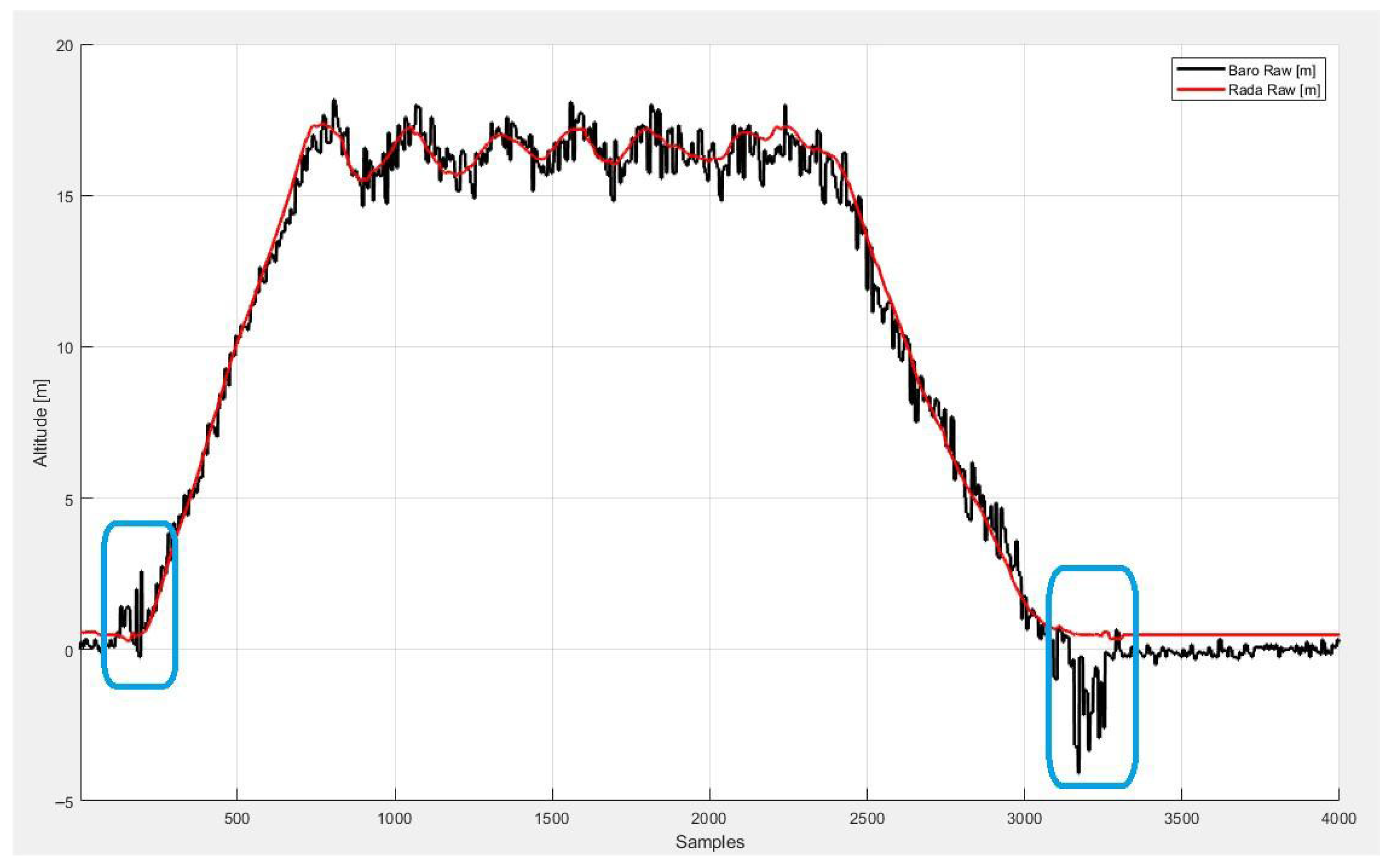
Barometric altimeters provide relative altitude measurements based on atmospheric pressure. Although barometric measurements offer stable long-term trends and are effective for capturing altitude changes, they are highly sensitive to airflow disturbances near the ground. During takeoff and landing, propeller downwash and ground proximity effects introduce pressure fluctuations that lead to biased and oscillatory barometric altitude estimates [6,18]. These ground effect-induced disturbances can significantly degrade the reliability of barometric altitude near the surface, as shown in Figure 1.
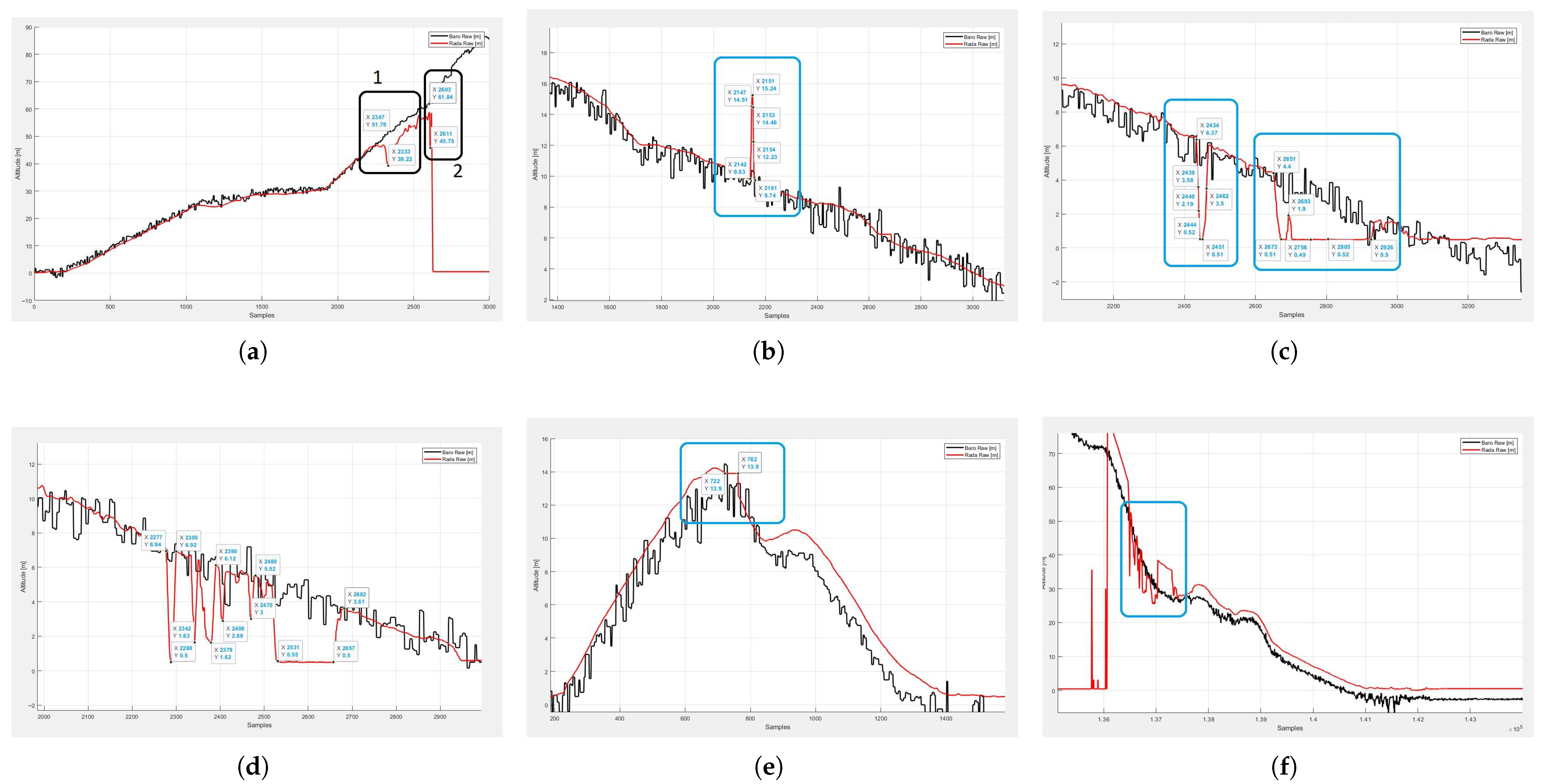
Radar altimeters directly measure the distance between the UAV and the ground, providing accurate AGL measurements within a limited operational range, typically below 50 m. In nominal conditions, radar altimeters offer high accuracy and low noise, making them well suited for autonomous landing. However, in practical UAV operations, radar altimeters frequently exhibit non-ideal behaviors that are not captured by standard sensor models, as shown in Figure 2. These behaviors include the following:
  • Out-of-range returns when the true altitude exceeds the operational range.
  • Frozen or repeated measurements over multiple sampling periods.
  • In-range biased measurements that remain within valid limits but deviate significantly from the true altitude.
  • Temporally smooth drifting measurements that gradually diverge from the true value.
  • Intermittent signal loss or inconsistent returns caused by terrain, surface properties, or sensor interference.
These anomalies often persist over multiple consecutive samples and may not be detectable using simple thresholding on measurement magnitude or rate of change. As a result, conventional Kalman filter-based fusion approaches that assume Gaussian measurement noise and nominal sensor behavior may incorporate faulty radar measurements, leading to degraded altitude estimation and unsafe landing behavior.

3.2. Vertical Motion Model

To address the above challenges, a vertical dynamic model is formulated to explicitly capture UAV vertical motion and sensor-related uncertainties [19]. The state vector is defined as
x = h k v z , k b a , k Δ h g , k
where h k denotes the UAV altitude relative to a reference takeoff point, v z , k is the vertical velocity in the inertial frame, b a , k represents the accelerometer bias along the vertical axis, and  Δ h g , k denotes the ground height offset relative to the barometric reference.
The ground height offset term Δ h g is introduced to account for two primary sources of error in barometric altitude estimation. First, it compensates for the difference in terrain elevation between the takeoff and landing locations. The barometric sensor provides altitude relative to the takeoff reference and therefore cannot capture changes in absolute ground elevation during flight. Although external terrain maps (e.g., SRTM [20]) could be used, their spatial resolution (typically 90 m × 90 m) and vertical accuracy (approximately 5–9 m) are insufficient for low-altitude UAV operations. Second, Δ h g captures the slow drift of the barometric sensor over time. In practical flight conditions, barometric drift can accumulate gradually, with observed deviations on the order of several meters over extended flight durations (e.g., approximately 5 m per hour).
The state Δ h g is modeled as a slowly varying quantity. Its observability is conditional and depends on the availability of reliable TOF measurements, which provide direct altitude information relative to the ground. During low-altitude operations where the TOF sensor operates within its valid range, Δ h g can be effectively estimated and updated.
In contrast, when TOF measurements are unavailable or unreliable (e.g., during high-altitude flight or out-of-range conditions), the ground height offset becomes weakly observable and relies primarily on prior estimates. As a result, the convergence of Δ h g depends on the duration and quality of valid TOF observations, typically occurring during descent and landing phases.
Furthermore, the model assumes that terrain variation is relatively slow compared to the estimator update rate. In scenarios involving rapid terrain changes, this assumption may lead to delayed or biased estimation of Δ h g , which represents a limitation of the proposed approach.
The discrete-time vertical dynamics are modeled as
x k + 1 = F x k + B a z , k + w k
where a z , k is the vertical acceleration in the inertial frame obtained from the IMU and attitude information, F is the state transition matrix, B is the input matrix, and  w k represents process noise accounting for modeling uncertainties and unmodeled disturbances. This formulation enables joint estimation of altitude, vertical velocity, accelerometer bias, and ground height offset, allowing the filter to adapt to slowly varying terrain elevation and sensor biases during landing and low-altitude flight.
F = 1 Δ t 0.5 Δ t 2 0 0 1 Δ t 0 0 0 1 0 0 0 0 1
B = 0.5 Δ t 2 Δ t 0 0
a z = g 1 + a x b sin θ + cos θ ( a y b sin ϕ + a z b cos ϕ )
where Δ t denotes the discrete-time sampling interval, ϕ and θ are roll and pitch angles of the UAV, a x b , a y b , and  a z b are accelerations in the body frame and g represents the gravitational acceleration, approximately 9.81 m / s 2 .
The vertical acceleration used in the estimator is derived from the body-frame accelerometer measurements by transforming them into the navigation frame and compensating for gravity. Let a b = [ a x b , a y b , a z b ] T denote the measured acceleration in the body frame, and let R ( ϕ , θ , ψ ) be the rotation matrix from the body frame to the navigation frame. The vertical acceleration component along the down direction is given by
a D = g + 0 0 1 R ( ϕ , θ , ψ ) a b
R ( ϕ , θ , ψ ) = c θ c ψ s ϕ s θ c ψ c ϕ s ψ c ϕ s θ c ψ + s ϕ s ψ c θ s ψ s ϕ s θ s ψ + c ϕ c ψ c ϕ s θ s ψ s ϕ c ψ s θ s ϕ c θ c ϕ c θ
where g denotes the gravitational acceleration,   s = sin ( ) , and c = cos ( ) . In this work, the vertical axis is defined with the positive direction upward. Therefore, the vertical acceleration used in the Kalman filter is a z = a D
In addition, the process noise and measurement noise are modeled using covariance matrices Q and R, respectively. The process noise covariance Q reflects the uncertainty in the system dynamics, primarily associated with accelerometer noise and bias variations. Smaller values of Q indicate higher confidence in the motion model and inertial measurements. In this work, Q is selected based on the noise characteristics specified in the IMU datasheet. The measurement noise covariance R represents the uncertainty of the barometric and TOF altitude measurements. Smaller values of R indicate higher confidence in the sensor observations. The nominal values of R are determined based on the measurement accuracy of the sensors, approximated as the squared noise levels of the barometric sensor and radar altimeter.

3.3. Measurement Models

Two primary measurement sources are considered: barometric altitude and radar AGL altitude. The barometric altitude measurement is modeled as
z k b a r o = h k + v k b a r o
where v k b a r o denotes barometric measurement noise and disturbances, including ground effect-induced fluctuations near the surface. The radar altimeter measurement provides AGL distance and is modeled as
z k r a d a r = h k Δ h g , k + v k r a d a r
where v k r a d a r represents radar measurement noise. Under nominal conditions, v k r a d a r is assumed to be zero-mean Gaussian. However, in practical operations, radar measurements may be affected by structured anomalies that violate this assumption, motivating the development of additional anomaly detection and handling logic described in the subsequent sections.

3.4. Problem Statement

Given the nonlinear and non-ideal behaviors of barometric and radar altimeters in real UAV operations, the objective of this work is to design a fault-tolerant altitude estimation framework that achieves the following:
  • Provides accurate and smooth estimates of altitude and vertical velocity during all flight phases.
  • Maintains reliable AGL estimation during low-altitude flight and autonomous landing.
  • Detects and handles multiple types of radar altimeter anomalies that cannot be adequately modeled as Gaussian noise.
  • Mitigates barometric ground effect disturbances near the surface.
To achieve these objectives, a hybrid framework is developed that combines a Kalman filter-based state-space estimator with a rule-based radar anomaly detection and classification module, enabling robust and adaptive sensor fusion under real-world operating conditions.

4. Hybrid Kalman–Rule-Based Altitude Estimation Framework

This section presents the proposed hybrid Kalman–rule-based framework for robust altitude and vertical speed estimation under non-ideal barometric and TOF altimeter behaviors. The framework combines a physics-based Kalman filter with a rule-based anomaly detection and classification module to explicitly handle multiple TOF altimeter failure modes observed in operational UAV flights. The overview of the algorithm is shown in Figure 3.

4.1. Overall Architecture

The proposed framework consists of three tightly coupled components: (i) a vertical-state Kalman filter for multi-sensor fusion, (ii) a rule-based TOF altimeter anomaly detection and classification module, and (iii) an adaptive fusion logic that modifies the Kalman measurement update based on the detected anomaly state.
The Kalman filter performs continuous estimation of the vertical state vector, which includes altitude, vertical velocity, accelerometer bias, and ground height offset. Barometric altitude and inertial measurements are always incorporated into the prediction and update steps. TOF altitude measurements are conditionally incorporated depending on their detected validity and anomaly type. The rule-based module continuously monitors raw TOF measurements, their temporal behavior, and their consistency with the predicted vertical state. Based on a set of empirically derived rules, the module classifies the TOF measurement into nominal or anomalous categories. The resulting anomaly state is then used to adaptively weight, downweight, or reject TOF measurements in the Kalman update. The proposed method is implemented according to the procedure described in Algorithm 1.
This hybrid structure enables the estimator to exploit high-fidelity TOF information when available while maintaining robustness against a wide range of non-ideal sensor behaviors that are not adequately handled by conventional Gaussian noise-based fusion.
Algorithm 1 Kalman–Rule-Based Altitude Estimation
  • Initialize: state x 0 = [ h , v , b , h g ] , covariance P 0
  • for each time step k do
  •       Input:  z k baro , z k tof , IMU data ( a x b , a y b , a z b ) , attitude data ( ϕ k , θ k )
  •       Compute altimeter flags:  f l a g b a r o , f l a g r a d a r
  •       Compute vertical acceleration:
    a z , k = f ( a x b , a y b , a z b , ϕ k , θ k )
  •       Prediction step:
    x k | k 1 = F x k 1 + B ( a z , k b a , k 1 )
    P k | k 1 = F P k 1 F + Q
  •       Adaptive TOF covariance selection R T O F
  •       Update step:  ( x k , P k ) KalmanUpdate ( )
  •       Output: altitude h k , vertical velocity v z , k , ground height offset h g , k
  • end for

4.2. Rule-Based Anomaly Detection and Classification

The proposed rule-based module is designed to detect and classify multiple altimeter anomaly modes observed in real UAV flight logs. Unlike generic outlier rejection schemes, which primarily rely on innovation magnitude thresholds, the proposed approach explicitly targets slow-varying, in-range biased, and persistent failure patterns [15,21] that are difficult to detect using conventional residual-based methods.
The anomaly detection operates over a sliding temporal window of TOF measurements and leverages multiple features, including: (i) absolute TOF altitude, (ii) prediction residual with respect to the Kalman filter estimate, (iii) temporal variation, and (iv) persistence of measurements.
For clarity and reproducibility, the feature definitions are formalized as follows. Let z T O F ( k ) denote the TOF measurement at time step k, and z p r e d ( k ) denote the predicted altitude. A sliding window of length N is defined as
W k = { z T O F ( k ) , z T O F ( k 1 ) , , z T O F ( k N + 1 ) } .
The following features are used:
r ( k ) = z T O F ( k ) z p r e d ( k )
Δ z ( k ) = z T O F ( k ) z T O F ( k 1 )
σ 2 ( k ) = Var ( W k )
Based on these features, the anomaly categories are defined through the following rule-based conditions:
  • Out-of-Range (OOR): z T O F ( k ) < z min or z T O F ( k ) > z max .
  • Frozen (FRZ): | z T O F ( k ) z T O F ( k i ) | < ϵ , i = 1 , , N .
  • In-Range High Bias (IR-HB): r ( k ) > T bias for N b consecutive samples.
  • In-Range Low Bias (IR-LB): r ( k ) < T bias for N b consecutive samples.
  • Oscillatory (OSC): σ 2 ( k ) > T var and z T O F ( k ) is near the upper sensing range.
  • Nominal (NOM): If none of the above conditions are satisfied.
The classification is implemented as a structured rule-based decision process, where conditions are evaluated sequentially with priority given to critical failure modes (e.g., out-of-range and frozen measurements). This prioritization ensures that severe faults are detected before secondary anomaly patterns.
The parameter values are selected empirically based on observed flight data and may vary depending on sensor characteristics and operating conditions. These representative values are chosen to balance robustness against false detections and sensitivity to real anomalies, as shown in Table 1.
The sliding time window used for anomaly detection is set to approximately 1 s. This choice represents a trade-off between detection reliability and responsiveness to valid measurements. A shorter window may not provide sufficient temporal information for reliable anomaly detection, while a longer window may delay the acceptance of recovered measurements, as past anomalous samples remain within the window. The selected window length ensures a balance between robustness and timely adaptation to measurement changes.
To facilitate integration with the estimation framework, measurement validity is represented using discrete state indicators, denoted as f l a g b a r o and f l a g r a d a r . These flags are derived from the rule-based detection process and encode the measurement reliability for adaptive fusion.
For the barometric sensor, two states are defined:
  • Good: Measurement is reliable.
  • Ground Effect: Measurement is affected by near-ground disturbances.
Near-ground operations often cause unstable barometric measurements due to rotor-induced airflow, resulting in rapidly fluctuating altitude readings. In this condition, both the estimated altitude and vertical velocity can become inaccurate if the barometric sensor is trusted. In addition, the barometric sensor suffers from drift over time and does not provide sufficient accuracy for precise landing when terrain elevation changes. To address these issues, the proposed method reduces reliance on barometric measurements under such conditions and incorporates radar-based TOF measurements to provide more reliable altitude information.
For the radar (TOF) altimeter, a more detailed set of states is used to capture diverse non-ideal behaviors:
  • Good: Measurement is valid and consistent.
  • No Signal: Measurement returns zero or indicates signal loss.
  • Out of Range: Measurement lies outside the valid operating range of the sensor.
  • Large Variation: Significant inter-sample changes inconsistent with physical motion.
  • Persistent Value: Measurement remains constant over multiple consecutive samples, indicating potential signal freezing or loss of update.
  • Minor Anomaly: Small but persistent deviations from expected behavior.
  • Terrain Mismatch: Significant discrepancy between radar-derived altitude and terrain-referenced altitude.
  • Barometric Mismatch: Significant discrepancy between radar and barometric altitude estimates.
These state indicators are subsequently used to adapt the Kalman filter measurement update, enabling context-aware fusion of TOF measurements.

4.3. Adaptive Measurement Handling in the Kalman Filter

The detected TOF anomaly state is incorporated into the Kalman filter measurement update through an adaptive measurement handling strategy. Rather than treating all TOF measurements equally, the proposed framework modifies the Kalman update logic according to the classified anomaly type.
For nominal TOF measurements, the standard Kalman measurement update is applied using the nominal TOF measurement noise covariance. For out-of-range and frozen measurements, the TOF measurement is fully rejected, and no TOF update is applied. For in-range biased measurements (IR-HB and IR-LB), the TOF measurement is not immediately rejected; instead, its influence is reduced by inflating the corresponding measurement noise covariance. This covariance inflation effectively downweights the biased measurement while still allowing gradual correction if the bias resolves.
For oscillatory or marginal acquisition conditions, a transitional handling mode is applied, in which the TOF measurement is incorporated with a moderately increased noise covariance to prevent excessive estimator oscillations during target acquisition. This strategy allows the estimator to smoothly transition from barometric-dominated to TOF-dominated altitude estimation as the UAV descends into the valid TOF range. Formally, the adaptive update can be expressed as
R T O F = R n o m , if NOM , if OOR or FRZ α b i a s R n o m , if IR - HB or IR - LB α O S C R n o m , if OSC
where R n o m denotes the nominal TOF measurement noise covariance, and α b i a s > 1 and α O S C > 1 are empirically tuned inflation factors determined from flight data. In this work, typical values are α b i a s [ 3 , 5 ] and α O S C [ 5 , 8 ] . The selection of these factors reflects the relative severity of each anomaly type: more severe anomalies correspond to larger covariance inflation, thereby reducing the trust in the associated measurements in the Kalman update. As these parameters depend on specific sensor characteristics, platform configurations, and operating conditions, fixed numerical values are not universally applicable; instead, representative values are selected to ensure a balance between robustness to anomalies and sensitivity to valid measurements.
A qualitative sensitivity analysis is conducted to evaluate the impact of key detection thresholds and covariance scaling parameters on system performance. Increasing threshold values generally reduces false anomaly detection but may delay or miss subtle fault conditions, while lower thresholds improve sensitivity at the expense of higher false alarm rates. Similarly, larger covariance inflation factors reduce the influence of anomalous measurements but may slow convergence when measurements recover. Experimental observations indicate that the proposed framework maintains stable performance within a reasonable range of parameter variations, demonstrating robustness to moderate tuning differences.
In addition to TOF adaptation, the proposed framework also accounts for barometric sensor degradation under ground effect conditions. When the barometer is classified as being affected by ground effect, its measurement noise covariance is adaptively increased to reflect reduced reliability due to local pressure disturbances. This adaptive inflation reduces the influence of biased barometric measurements during low-altitude phases such as takeoff and landing. Conversely, when the barometer operates under nominal conditions, the standard measurement noise covariance is retained. This complementary adaptation ensures that the estimator appropriately balances the contributions of barometric and TOF measurements across different flight regimes.

4.4. Consistency Checking with Predicted Vertical State

To improve robustness against slowly varying biased measurements, the rule-based module incorporates consistency checks between TOF measurements and the Kalman filter predicted altitude. Specifically, the innovation between the TOF measurement and the predicted altitude is monitored over a temporal window. Persistent innovations with consistent sign and magnitude are interpreted as indicative of in-range bias rather than random noise.
This temporal consistency-based logic allows the framework to distinguish between impulsive noise and systematic bias, which is critical for detecting failure modes that evolve slowly and remain within nominal bounds. By explicitly modeling this behavior in the rule-based logic, the proposed framework addresses a key limitation of conventional innovation-threshold-based gating.

4.5. Handling of Barometric Disturbances and Sensor Complementarity

While the rule-based logic primarily targets TOF anomalies, the proposed framework also implicitly mitigates barometric disturbances through sensor complementarity. During low-altitude flight, when barometric altitude is affected by ground effect-induced pressure disturbances, nominal TOF measurements are given higher relative weight, thereby stabilizing altitude and vertical speed estimates. Conversely, during high-altitude flight or under TOF anomaly conditions, the estimator naturally reverts to barometric and inertial information as the primary altitude sources.
This adaptive exploitation of sensor complementarity enables robust performance across a wide range of operating conditions without requiring hard switching logic. The proposed hybrid framework therefore provides a unified and fault-tolerant solution for altitude estimation in practical UAV systems.

5. Experimental Setup

5.1. Flight Dataset

The proposed framework was evaluated using a dataset of 39 real UAV flight logs collected from multiple operational platforms. The UAVs are medium-size quadrotor systems capable of vertical takeoff and landing (VTOL), equipped with a high-resolution barometric pressure sensor (MS5611, TE Connectivity, Schaffhausen, Switzerland [22]), a downward-facing radar-based TOF altimeter, and an IMU providing three-axis accelerometer and gyroscope measurements (ADIS series, Analog Devices Inc., Wilmington, MA, USA [23]).
The radar-based TOF altimeter provides direct altitude measurements relative to the ground with an effective operating range of approximately 0–50 m, which is typical for low-altitude UAV operations such as takeoff, landing, and terrain following. All sensor data were time-synchronized and recorded at their native sampling rates during real flight missions.
The dataset includes logs from different UAV platforms and operational scenarios, covering both manually piloted flights and fully autonomous missions. The flight profiles span a wide range of scenarios, including low-altitude hovering, aggressive vertical maneuvers, high-altitude cruise, and autonomous landing sequences.
The experiments were conducted in outdoor environments under diverse conditions, including both flat terrain and hilly areas. The flights were performed in open environments rather than dense urban settings, avoiding strong multipath effects and human interference. A variety of environmental conditions were encountered during data collection; however, flights were not conducted under severe weather conditions such as heavy rain or storms.
Across all flight logs, barometric measurements exhibit disturbances caused by ground effect during near-ground operations, particularly in takeoff and landing phases. Similarly, the radar-based TOF altimeter shows various non-ideal behaviors, including out-of-range returns, frozen measurements, in-range biased readings, and oscillatory behavior near the upper sensing range. These phenomena are consistently observed across the dataset and reflect realistic operational conditions.
For high-altitude flight logs, it is observed that during cruise phases above approximately 60 m, the altimeters behave nominally without significant anomalies. Therefore, for these cases, the evaluation focuses on the takeoff and landing phases, where sensor disturbances and anomaly conditions are most pronounced.
Minimal preprocessing was applied to the dataset to remove only gross data corruption (e.g., missing timestamps). No manual labeling or anomaly filtering was performed prior to evaluation, ensuring that the dataset represents real-world sensor behavior under practical UAV operating conditions.

5.2. Reference Altitude and Evaluation Metrics

In real-world UAV operations, reliable ground-truth altitude is generally unavailable, particularly for low-altitude flight and landing scenarios. Therefore, instead of relying on absolute quantitative error metrics, the performance of the proposed framework is evaluated using qualitative criteria based on consistency with sensor behavior and flight dynamics.
The evaluation focuses on the ability of the estimator to (i) follow reliable TOF measurements when the radar altimeter operates nominally, and (ii) appropriately reject or downweight TOF measurements when anomalies occur. In particular, the estimated AGL altitude is examined in terms of its agreement with radar measurements under nominal conditions, and its robustness when the radar exhibits known failure modes such as bias, freezing, or out-of-range behavior.
During descent and landing phases, additional qualitative assessment is conducted by analyzing the stability and smoothness of the estimated altitude profile, as well as its consistency with expected flight behavior. Particular attention is given to scenarios involving terrain variation and ground effect disturbances, where conventional fusion approaches often exhibit unstable or inconsistent behavior.
This evaluation methodology reflects practical deployment conditions, where reliable ground truth is not available, and estimator performance must be assessed based on physical consistency, robustness to sensor anomalies, and overall operational reliability rather than absolute numerical error metrics.
To complement the qualitative assessment, several objective proxy indicators are considered. These include the temporal consistency of the estimated altitude with respect to reliable TOF measurements, the suppression of anomaly-induced deviations, and the stability of the estimated vertical profile during transitions between sensor modalities. In addition, the consistency of innovation behavior is monitored to assess whether anomalous measurements are effectively downweighted or rejected. These indicators provide indirect yet meaningful evaluation of estimation performance in the absence of absolute ground truth.

5.3. Implementation Details

The proposed hybrid Kalman–rule-based estimator was implemented in a real-time compatible framework consistent with embedded UAV avionics constraints.
The dataset was divided into two disjoint subsets for parameter tuning and evaluation. A subset of 10 flight logs was used for tuning the Kalman filter parameters and anomaly detection thresholds. These tuning logs were selected to be representative of typical operating conditions and include complete flight profiles with takeoff, cruise, and landing phases.
The remaining 29 flight logs were used exclusively for evaluation. No overlap exists between the tuning and evaluation sets, and no parameter retuning was performed during evaluation. This ensures that the reported results reflect the generalization capability of the proposed method rather than dataset-specific optimization.
The rule-based anomaly detection thresholds were derived empirically from the tuning subset based on observed TOF sensor behavior and then validated across the full evaluation dataset.
The proposed framework introduces minimal computational overhead compared to a standard Kalman filter. The additional rule-based detection and covariance adaptation involve simple operations, making the method suitable for real-time embedded UAV systems.
The overall complexity remains linear per time step, as the additional rule-based anomaly detection involves only simple logical operations and window-based statistics. The method is compatible with real-time onboard implementation and can operate within typical UAV control loop rates (e.g., 100 Hz), making it suitable for embedded systems with limited computational resources.

6. Results and Discussion

6.1. Overall Altitude Estimation Accuracy

Across the full dataset, the proposed hybrid framework generally produces more stable and physically consistent altitude estimates compared with the baseline methods. Relative to the Baro-KF baseline, the proposed method exhibits more stable behavior during low-altitude flight, where barometric disturbances due to ground effect are most pronounced. The incorporation of TOF measurements helps reduce fluctuations induced by near-ground barometric disturbances.
Compared with the Standard Fusion KF and Threshold-Gated KF, the proposed method shows improved robustness in the presence of TOF anomalies. While standard fusion approaches may follow corrupted TOF measurements under in-range bias or frozen conditions, the proposed framework selectively downweights or rejects such measurements, resulting in more consistent altitude estimation behavior.
All figures in this section illustrate the performance of the proposed algorithm using real UAV flight data. For consistency, the following color conventions are used throughout the plots:
  • Green: Raw barometric altitude (m).
  • Cyan: Raw radar (TOF) altitude (m).
  • Black: Estimated altitude relative to the takeoff point (m).
  • Red: Estimated above-ground-level (AGL) altitude (m).
  • Blue: Estimated vertical velocity (positive upward) (m/s).
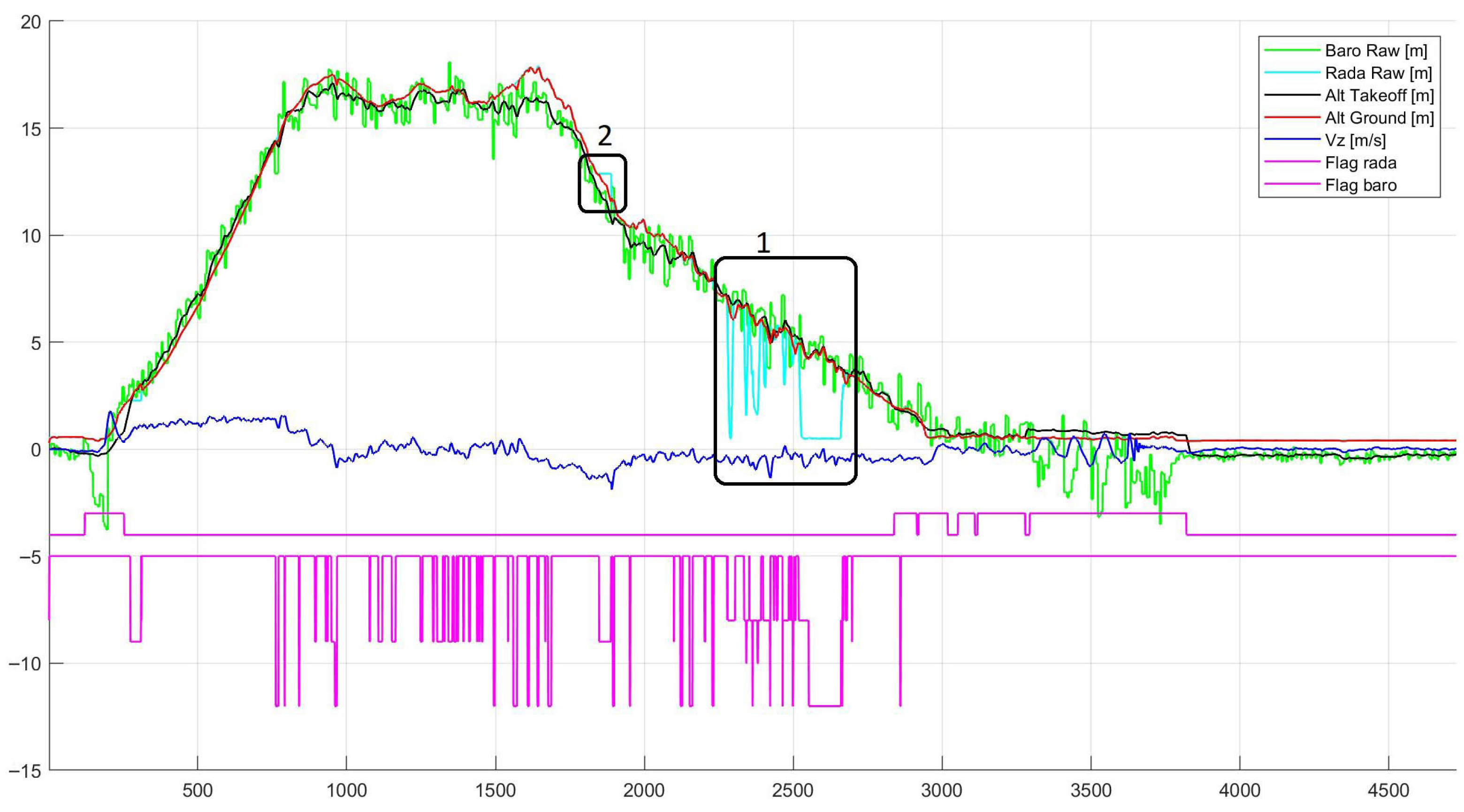
  • Magenta: Sensor state indicators, where the upper trace corresponds to 4 + f l a g b a r o and the lower trace corresponds to 5 f l a g r a d a r . A value of zero indicates nominal operation (Good), while nonzero values represent different anomaly states as defined in the following section. When both sensors operate nominally, the two traces remain at constant levels of 4 and 5 , respectively.
Based on empirical observations, high-altitude cruise phases (typically above 60 m) exhibit stable and nominal sensor behavior, with no significant anomalies observed in the evaluated flight logs. Therefore, for clarity and relevance, the figures focus on the takeoff and landing phases, where sensor non-idealities such as ground effect and radar anomalies are most pronounced.
The results demonstrate that the estimated altitude relative to the takeoff point and the above-ground-level (AGL) altitude generally follow the barometric and radar measurements when both sensors operate under nominal conditions. The estimated vertical velocity is consistent with the trend of the takeoff-referenced altitude, accurately reflecting climb and descent phases without introducing spurious oscillations.
The proposed framework is designed with a sensor-agnostic and modular structure, allowing adaptation to different UAV platforms and altimeter types. By adjusting parameter ranges based on sensor characteristics, the method can be extended to various radar or laser altimeters without requiring structural modifications to the estimation framework. This supports its applicability across a wide range of UAV systems and operational scenarios.
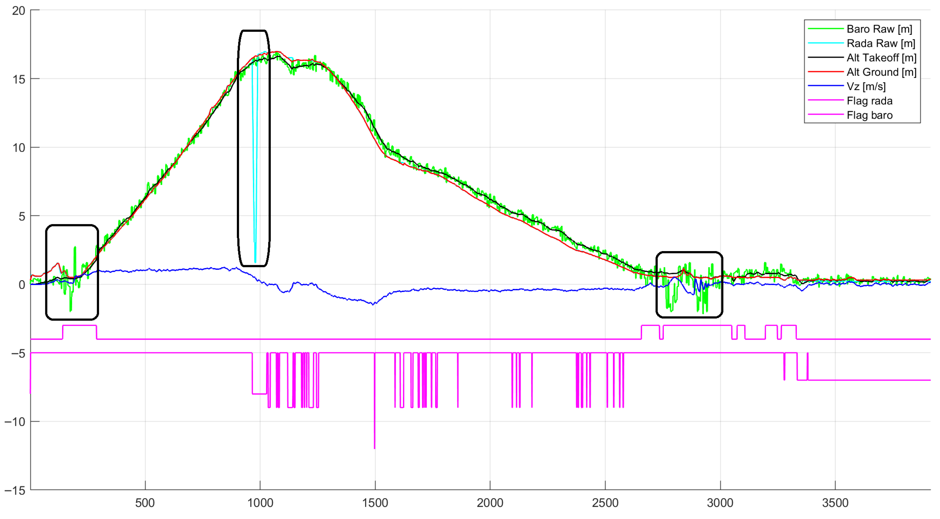
Regarding ground effect conditions, the proposed framework successfully detects barometric disturbances across all tested scenarios. As illustrated in the figure, the estimated takeoff-referenced altitude remains smooth and is not affected by the oscillatory behavior of raw barometric measurements near the ground. Consequently, the estimated vertical velocity does not exhibit significant chattering, ensuring stable behavior during critical phases such as autonomous landing, as shown in Figure 4.
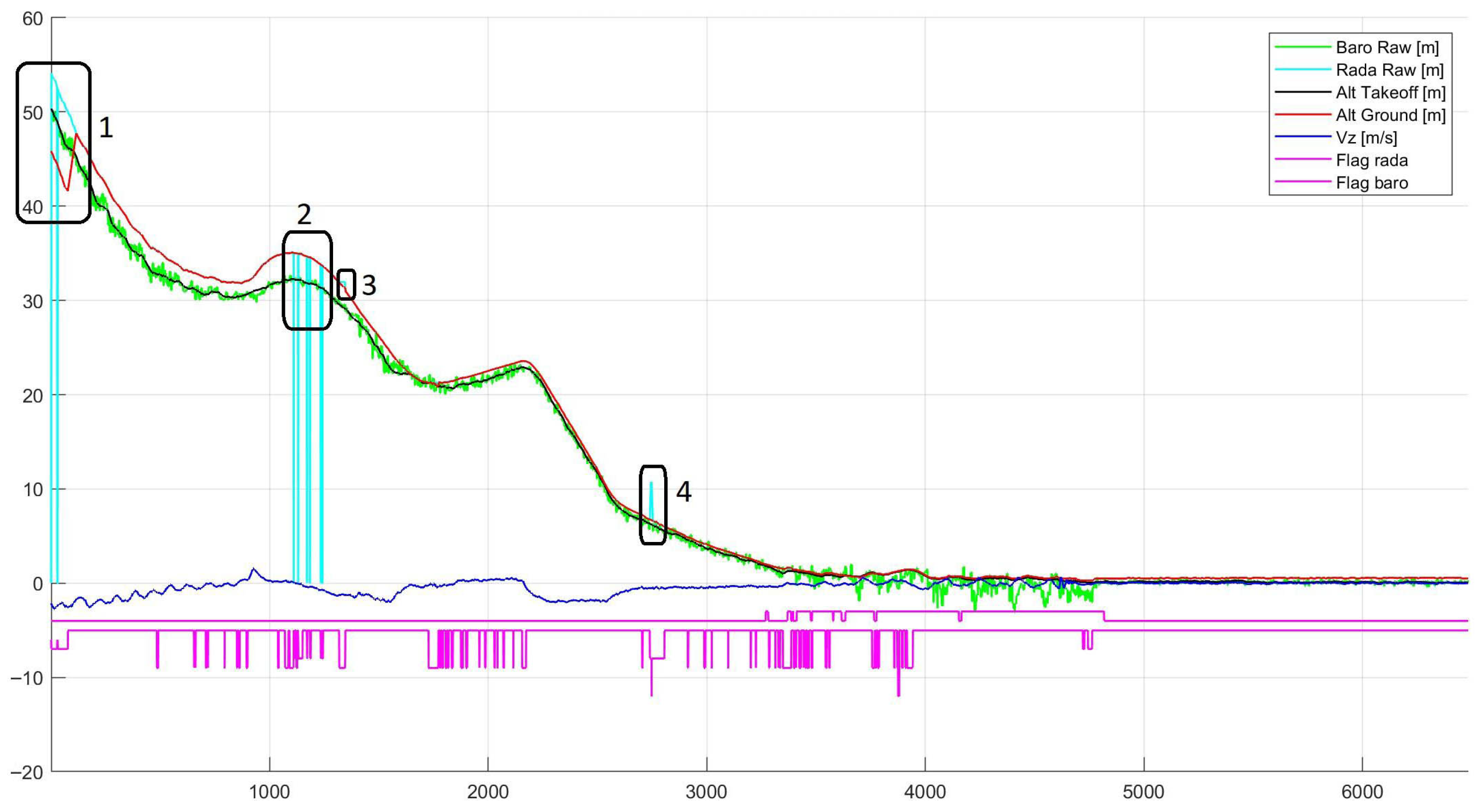
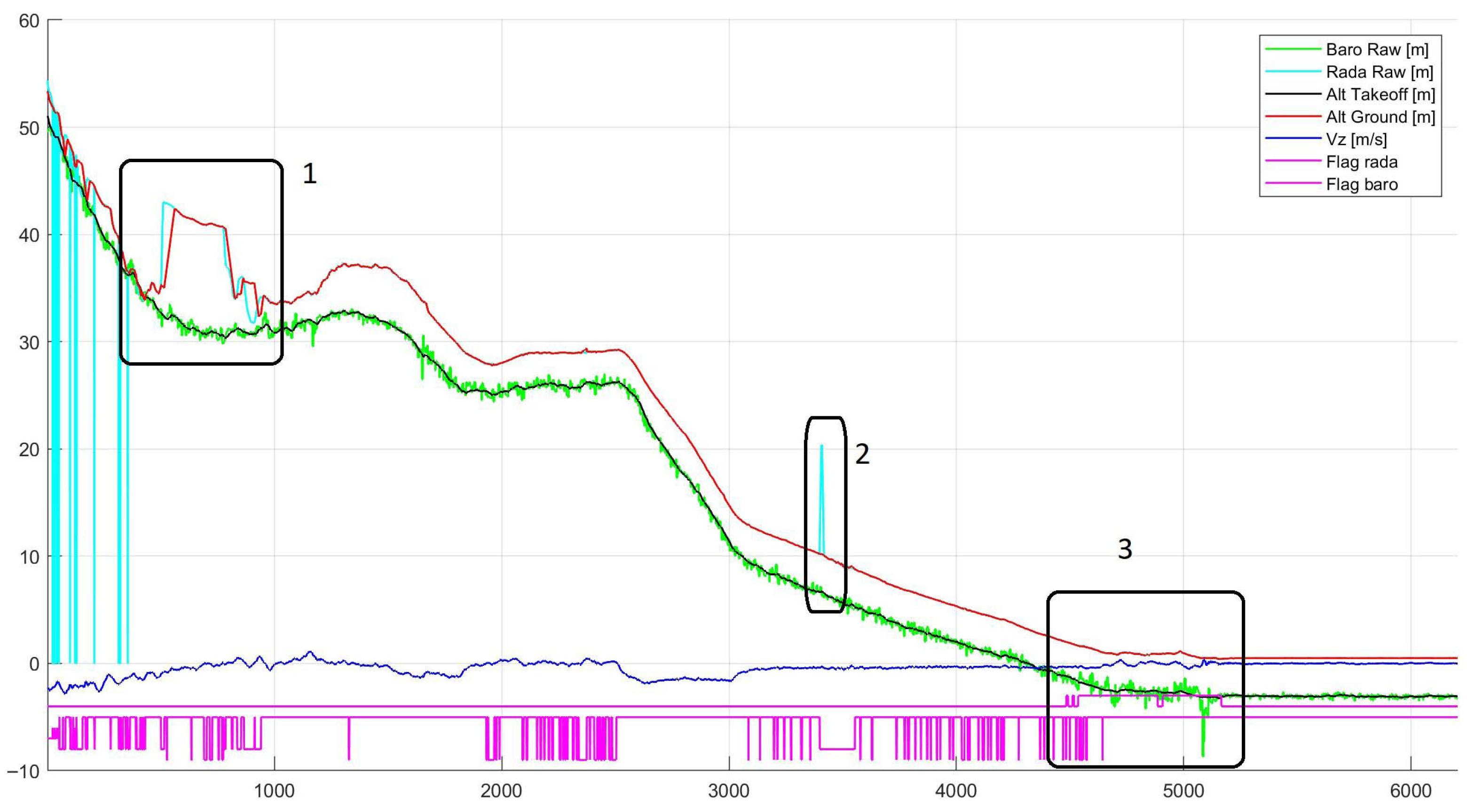
The results demonstrate that anomalous radar measurements are consistently detected and appropriately handled by the proposed framework. As illustrated in the Figure 5, erroneous radar outputs are successfully identified and prevented from degrading the estimation.
During these periods, the estimator either downweights or rejects the affected radar measurements, allowing the altitude estimate to remain stable and physically consistent. As a result, the estimated altitude does not follow the corrupted radar data and instead maintains a smooth and reliable profile.
For high-altitude flight logs, the proposed framework demonstrates stable AGL estimation during the descent phase. As shown in Figure 6 and Figure 7, the estimated ground-referenced altitude converges to a consistent value early in the descent, even before reaching low-altitude conditions. These results highlight the capability of the proposed method to maintain stable altitude estimation across different flight regimes, including high-altitude descent scenarios where TOF measurements gradually become available.
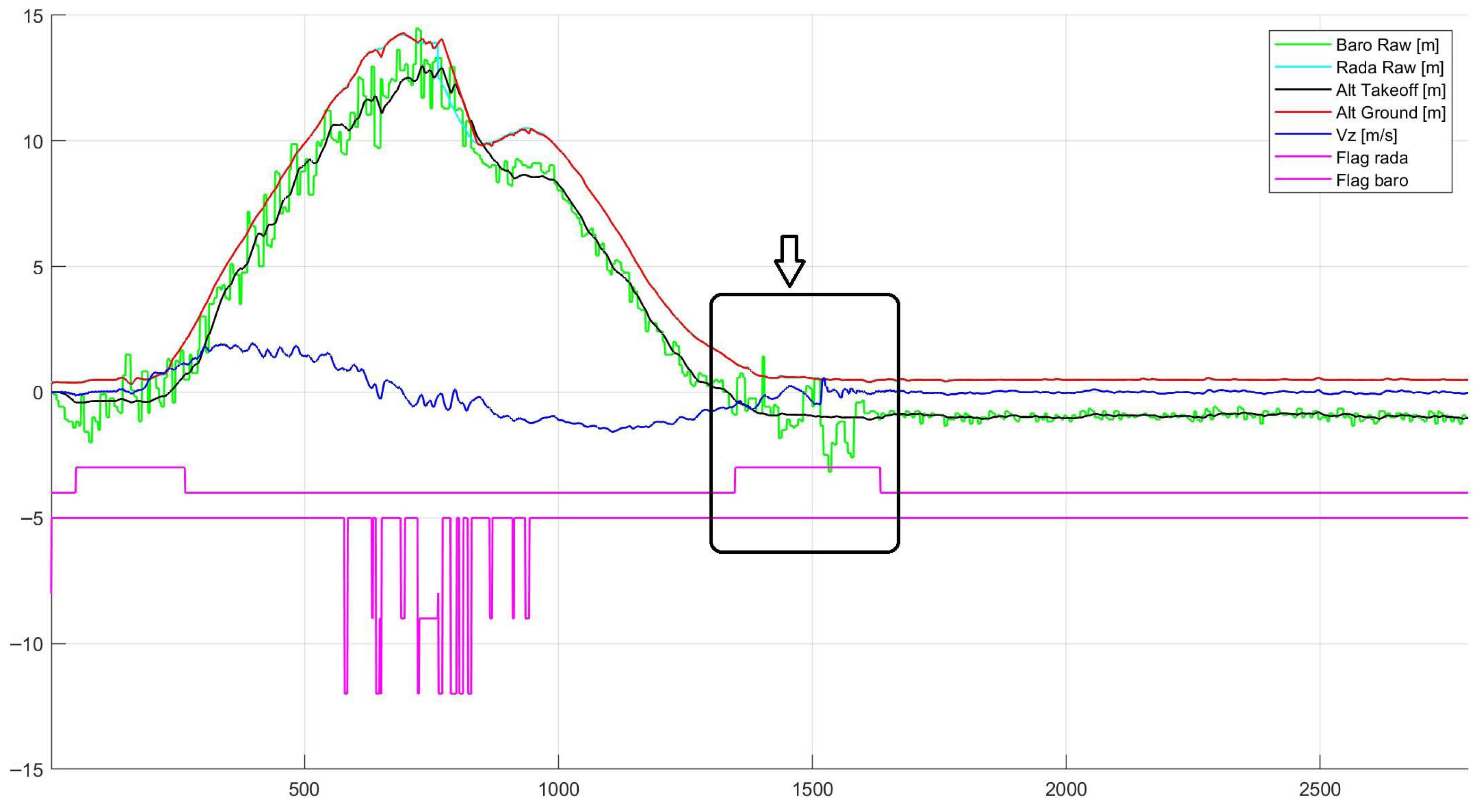
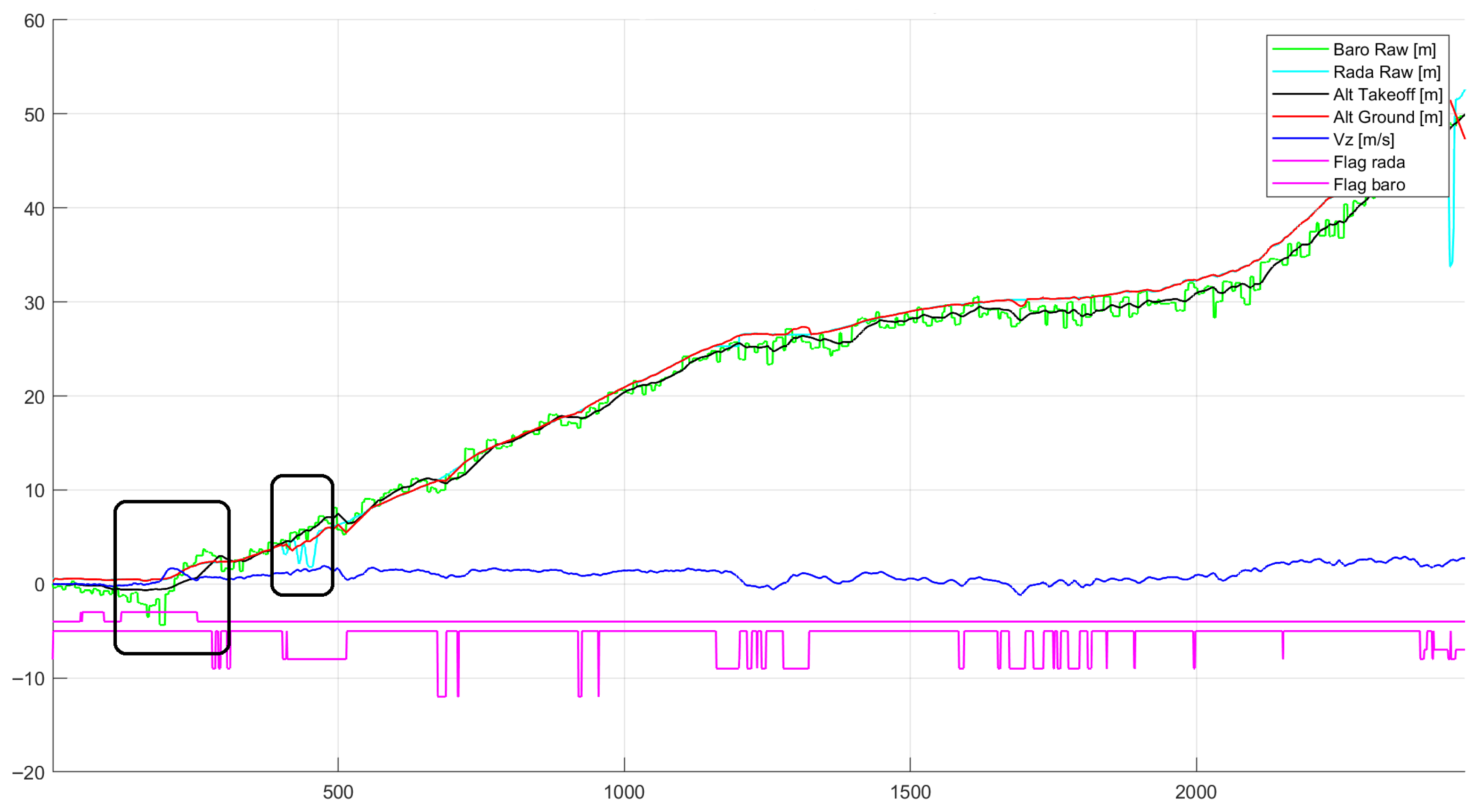
Figure 8 illustrates representative low-altitude flight logs where the proposed framework mitigates ground-effect-induced disturbances and detects radar measurement anomalies during takeoff and landing. Figure 9 presents a takeoff scenario in which the proposed framework successfully detects simultaneous anomalies in both barometric and radar measurements.
These results indicate that the proposed method effectively preserves reliable sensor information under nominal conditions while mitigating the impact of ground effect-induced disturbances, contributing to improved the robustness and stability of altitude estimation.

6.2. Vertical Speed Estimation Performance

Vertical speed estimation showed improved performance. Barometric disturbances near the ground introduced spurious short-term altitude fluctuations that propagated into large vertical speed errors in the Baro-KF baseline. The proposed framework helped reduce these effects by leveraging stable TOF measurements when available and suppressing corrupted TOF data when anomalies were detected.
This improvement is especially important for autonomous landing, where vertical speed accuracy directly affects flare timing and touchdown quality.

6.3. Robustness Under TOF Anomalies

Qualitative and quantitative analysis during TOF anomaly events demonstrated the clear advantages of the proposed hybrid approach. In-range biased TOF measurements that persisted for extended periods caused noticeable estimator drift in the Standard Fusion KF and Threshold-Gated KF baselines. In contrast, the proposed rule-based classification identified these conditions and applied covariance inflation or rejection, preventing long-term estimator corruption.
Frozen TOF outputs and marginal oscillatory behavior near the TOF range boundary were also handled effectively. The transitional handling strategy enabled smooth switching between barometric-dominated and TOF-dominated estimation, reducing estimator oscillations and improving stability during descent.

6.4. Autonomous Landing Performance

During autonomous landing sequences, the proposed method produced more stable and consistent altitude estimates in the final approach and flare phases. Reduced altitude noise and improved vertical speed accuracy translated into smoother descent profiles and more repeatable touchdown behavior. These results highlight the operational relevance of the proposed framework for safety-critical UAV applications.
Overall, the results demonstrate that explicitly modeling and handling real-world TOF altimeter anomalies is critical for achieving robust altitude estimation. The hybrid Kalman–rule-based design provides a practical balance between model-based estimation and empirical fault handling.

7. Conclusions

This paper presented a hybrid Kalman–rule-based altitude estimation framework for UAVs that fuses barometric and TOF altimeter measurements while explicitly addressing real-world sensor non-idealities. The complementary characteristics of barometric and TOF sensors were analyzed, and extensive flight data revealed multiple recurring TOF anomaly modes that are not adequately handled by conventional fusion approaches.
The main contribution of this work lies in the integration of rule-based anomaly classification with a physics-based Kalman filter. Unlike standard fusion methods that rely solely on statistical consistency, the proposed framework explicitly distinguishes between different anomaly types and adapts the measurement update accordingly. This enables selective rejection or downweighting of corrupted measurements while still exploiting reliable TOF data when available. As a result, the method achieves improved robustness under practical operating conditions, particularly in the presence of structured and persistent sensor faults.
The framework is lightweight and suitable for real-time implementation, as it introduces only minimal computational overhead beyond a standard Kalman filter. Furthermore, it can be adapted to different UAV platforms by tuning parameters according to sensor characteristics, such as noise levels and sampling rates, making it applicable across a wide range of hardware configurations.
Validation on 39 real UAV flight logs demonstrated consistent improvements in estimation stability and robustness compared with barometer-only and conventional fusion methods. The proposed approach is particularly effective during low-altitude operations and landing phases, where ground effect-induced barometric disturbances and TOF anomalies are most critical.
It should be noted that the absence of reliable ground-truth altitude limits the use of quantitative error metrics. Therefore, the evaluation focuses on consistency with sensor behavior and flight dynamics under realistic operational conditions. Despite this limitation, the results demonstrate clear practical benefits of the proposed approach.
Future work will focus on incorporating ground-truth-enabled datasets (e.g., RTK-GNSS) for quantitative validation, extending the framework to additional sensing modalities such as vision or lidar, and exploring learning-assisted anomaly detection methods to further improve adaptability across different environments and sensor types.

Author Contributions

Conceptualization, T.D.N. and V.D.V.; methodology, T.D.N. and V.D.V.; software, X.S.M.; validation, X.S.M.; formal analysis, V.D.V.; investigation, M.V.T.; resources, M.V.T. and X.S.M.; data curation, V.D.V.; writing—original draft preparation, K.T.L.; writing—review and editing, V.D.V. and T.D.N.; visualization, V.D.V. and K.T.L.; supervision, T.D.N.; project administration, T.D.N. All authors have read and agreed to the published version of the manuscript.

Funding

This research received no external funding.

Data Availability Statement

The data presented in this study are not publicly available due to proprietary restrictions. The data belong to Viettel High Technology Industries Corporation (Viettel High Tech), Viettel Group.

Acknowledgments

The authors would like to thank the engineering and flight test teams at Viettel High Technology Industries Corporation, Viettel Group for their support in data collection and system validation.

Conflicts of Interest

All authors were employed by the company Viettel High Technology Industries Corporation. The authors declare that the research was conducted in the absence of any commercial or financial relationships that could be construed as a potential conflict of interest.

Abbreviations

The following abbreviations are used in this manuscript:
UAVUnmanned Aerial Vehicle
TOFTime Of Flight
AGLAbove Ground Level
IMUInertial Measurement Unit
KFKalman Filter
EKFExtended Kalman Filter

References

  1. Gautam, A.; Sujit, P.B.; Saripalli, S. A survey of autonomous landing techniques for UAVs. In Proceedings of the 2014 International Conference on Unmanned Aircraft Systems (ICUAS), Orlando, FL, USA, 27–30 May 2014; pp. 1210–1218. [Google Scholar] [CrossRef]
  2. Advanced Navigation. Inertial Measurement Unit (IMU)—An Introduction; Advanced Navigation: Sydney, Australia, 2023. [Google Scholar]
  3. Frick, S. Radar Altimeters: Overview of Operation, Design, and Performance; Technical Report; Aerospace Vehicle Systems Institute (AVSI): College Station, TX, USA, 2021. [Google Scholar]
  4. Choi, K.S.; Hyun, J.W.; Jang, J.W.; Ahn, D.M.; Hong, G.Y. Ground Altitude Measurement Algorithm using Laser Altimeter and Ultrasonic Rangefinder for UAV. J. Korea Navig. Inst. 2013, 17. [Google Scholar] [CrossRef]
  5. Groves, P. Principles of GNSS, Inertial, and Multisensor Integrated Navigation Systems, 2nd ed.; Artech House: Norwood, MA, USA, 2013. [Google Scholar]
  6. Kendoul, F. Survey of Advances in Guidance, Navigation, and Control of Unmanned Rotorcraft Systems. J. Field Robot. 2012, 29, 315–378. [Google Scholar] [CrossRef]
  7. Oleynikova, H.; Honegger, D.; Pollefeys, M. Reactive avoidance using embedded stereo vision for MAV flight. In Proceedings of the 2015 IEEE International Conference on Robotics and Automation (ICRA), Seattle, WA, USA, 26–30 May 2015; pp. 50–56. [Google Scholar] [CrossRef]
  8. Wei, B.; Nener, B. Distributed Space Debris Tracking with Consensus Labeled Random Finite Set Filtering. Sensors 2018, 18, 3005. [Google Scholar] [CrossRef] [PubMed]
  9. Bar-Shalom, Y.; Li, X.R.; Kirubarajan, T. Estimation with Applications to Tracking and Navigation: Theory, Algorithms and Software; Wiley: Hoboken, NJ, USA, 2001. [Google Scholar] [CrossRef]
  10. Titterton, D.; Weston, J. Strapdown Inertial Navigation Technology; The Institution of Engineering and Technology: Hertfordshire, UK, 2004. [Google Scholar]
  11. Blom, H.; Bar-Shalom, Y. The interacting multiple model algorithm for systems with Markovian switching coefficients. IEEE Trans. Autom. Control 1988, 33, 780–783. [Google Scholar] [CrossRef]
  12. Kaplan, E.D.; Hegarty, C.J. Understanding GPS: Principles and Applications, 2nd ed.; Comprehensive Resource on GNSS Systems, Including GPS, GLONASS, and Galileo; Artech House: Boston, MA, USA, 2006. [Google Scholar]
  13. Albéri, M.; Baldoncini, M.; Bottardi, C.; Chiarelli, E.; Fiorentini, G.; Raptis, K.G.C.; Realini, E.; Reguzzoni, M.; Rossi, L.; Sampietro, D.; et al. Accuracy of Flight Altitude Measured with Low-Cost GNSS, Radar and Barometer Sensors: Implications for Airborne Radiometric Surveys. Sensors 2018, 17, 1889. [Google Scholar] [CrossRef] [PubMed]
  14. Faessler, M.; Fontana, F.; Forster, C.; Scaramuzza, D. Automatic re-initialization and failure recovery for aggressive flight with a monocular vision-based quadrotor. In Proceedings of the 2015 IEEE International Conference on Robotics and Automation (ICRA), Seattle, WA, USA, 26–30 May 2015; pp. 1722–1729. [Google Scholar] [CrossRef]
  15. Rong Li, X.; Jilkov, V. Survey of maneuvering target tracking. Part V. Multiple-model methods. IEEE Trans. Aerosp. Electron. Syst. 2005, 41, 1255–1321. [Google Scholar] [CrossRef]
  16. Ye, X.; Song, F.; Zhang, Z.; Zeng, Q. A Review of Small UAV Navigation System Based on Multisource Sensor Fusion. IEEE Sens. J. 2023, 23, 18926–18948. [Google Scholar] [CrossRef]
  17. Gu, Y.; Gross, J.N.; Rhudy, M.B.; Lassak, K. A Fault-Tolerant Multiple Sensor Fusion Approach Applied to UAV Attitude Estimation. Int. J. Aerosp. Eng. 2016, 2016, 6217428. [Google Scholar] [CrossRef]
  18. Le, K.T.; Nguyen, T.T.; Nguyen, T.D. Improving UAV Altitude Estimation Using Barometric Sensor: A Method via Data Analysis. In Proceedings of the 2025 International Conference on Electrical Engineering and Informatics (ICEEI), Kuching, Malaysia, 13–15 November 2025. [Google Scholar]
  19. Gracey, W. Measurement of Aircraft Speed and Altitude; John Wiley & Sons: New York, NY, USA, 1981. [Google Scholar]
  20. NASA/USGS. Shuttle Radar Topography Mission (SRTM) Digital Elevation Data; ESDS: Nashik, India, 2000.
  21. Hesch, J.; Kottas, D.; Bowman, S.; Roumeliotis, S. Consistency Analysis and Improvement of Vision-aided Inertial Navigation. Robot. IEEE Trans. 2014, 30, 158–176. [Google Scholar] [CrossRef]
  22. TE Connectivity. MS5611-01BA03 Datasheet; TE Connectivity: Berwyn, PA, USA, 2023. [Google Scholar]
  23. Analog Devices. ADIS Series MEMS Inertial Measurement Units Datasheet; Analog Devices: Wilmington, MA, USA, 2020. [Google Scholar]
Figure 1. Barometric altimeter ground effect. It can be observed that near the ground level during takeoff and landing, the signal exhibits larger oscillations and a noticeable bias, with the estimated values deviating either above or below the true altitude.
Drones 10 00369 g001
Figure 2. Observed non-ideal behaviors of the radar altimeter: (a) At time instants 1 and 2, the true altitude is outside the valid measurement range, yet the radar outputs erroneous values within the nominal range; (b) the radar overestimates the true altitude; (c) the radar underestimates the true altitude and may remain quasi-stable (non-constant) for nearly 300 consecutive samples; (d) in-range erroneous measurements may occur repeatedly over consecutive periods; (e) the radar output becomes frozen, remaining constant for approximately 40 consecutive samples; (f) low-frequency oscillations are observed when descending below 50 m.
Drones 10 00369 g002
Figure 3. Overview of the Method.
Drones 10 00369 g003
Figure 4. Mitigation of ground effect-induced disturbances. The altitude relative to the takeoff point remains stable and is not influenced by barometric fluctuations.
Drones 10 00369 g004
Figure 5. Detection and mitigation of radar measurement anomalies: (1) in-range biased measurements relative to the true altitude; (2) persistent frozen measurements over consecutive samples.
Drones 10 00369 g005
Figure 6. Performance of the proposed method during landing using high-altitude flight logs: (1) accurate tracking of the true altitude under nominal radar conditions; (2) robust handling of erroneous radar measurements; (3) suppression of frozen radar outputs; (4) mitigation of radar overestimation.
Drones 10 00369 g006
Figure 7. Altitude estimation performance during the landing phase using high-altitude flight logs: (1) correct identification of nominal radar measurements over a terrain depression (6–7 m); (2) detection and mitigation of radar overestimation (10 m bias); (3) effective suppression of ground effect-induced disturbances.
Drones 10 00369 g007
Figure 8. Low-altitude flight logs showing that the proposed method effectively mitigates ground effect-induced disturbances during takeoff and landing, and also correctly detecting radar measurement anomalies.
Drones 10 00369 g008
Figure 9. Takeoff scenario illustrating that the proposed method successfully detects simultaneous anomalies in both barometric and radar measurements.
Drones 10 00369 g009
Table 1. Parameters used in anomaly detection.
SymbolDescriptionTypical Values
z min Sensor operating range0.3∼0.5 m
z max Sensor operating range50∼100 m
ϵ Threshold for frozen detection0.005∼0.02 m
NWindow length20∼100 samples (data in 1 s)
T bias Bias threshold0.3∼0.7 m
N b Bias persistence length20∼40 samples
T var Oscillation threshold0.2∼0.5 m
Disclaimer/Publisher’s Note: The statements, opinions and data contained in all publications are solely those of the individual author(s) and contributor(s) and not of MDPI and/or the editor(s). MDPI and/or the editor(s) disclaim responsibility for any injury to people or property resulting from any ideas, methods, instructions or products referred to in the content.