Review

Unmanned Aerial Vehicle Technologies, Applications, and Regulatory Frameworks: A Scoping Review

by
Muhammad Mbarak
,
Mohd Hasanul Alam
and
Mohammed Awad
*
Department of Computer Science and Engineering, American University of Ras Al Khaimah, Ras Al Khaimah 72603, United Arab Emirates
*
Author to whom correspondence should be addressed.
Drones 2026, 10(5), 365; https://doi.org/10.3390/drones10050365
Submission received: 12 March 2026 / Revised: 3 May 2026 / Accepted: 6 May 2026 / Published: 11 May 2026

Highlights

What are the main findings?
  • Following PRISMA-ScR methodology, this scoping review synthesises 109 sources across three domains, namely UAV platform technologies, civil applications in eight sectors, and global regulatory and ethical frameworks, providing a structured, cross-disciplinary knowledge map for researchers and practitioners initiating drone-based projects.
  • Research attention is heavily concentrated on autonomy and AI-driven control systems, with geographic dominance in US–European–Chinese contexts; critical knowledge gaps persist in economic feasibility analysis, interoperability standardization, developing-world deployment contexts, and environmental lifecycle assessment.
What are the implications of the main findings?
  • As UAV technology has matured sufficiently for widespread civilian adoption, deployment success increasingly depends on non-technical factors like early regulatory engagement, realistic economic planning, and ethical compliance rather than on capability constraints alone.
  • Fundamental contradictions between optimistic application scalability claims and persistent constraints in energy storage, swarm communication reliability, and privacy efficiency trade-offs highlight the urgent need for integrated, cross-disciplinary research to bridge the gap between laboratory demonstrations and real-world operations.

Abstract

The rapid proliferation of unmanned aerial vehicles (UAVs) in civilian sectors has generated diverse research spanning platform engineering, application deployment, and regulatory governance. This scoping review systematically maps the current knowledge landscape of civilian UAVs, their applications, and their regulatory frameworks, and aims to serve as initial practical guidance for researchers and practitioners initiating drone-based projects. Following PRISMA-ScR guidelines, a structured three-stream literature search was conducted using Google Scholar, yielding 109 sources published between 2015 and 2025. This review synthesises findings across three domains: (1) technical specifications, including UAV platform configurations, their common applications, their advantages and limitations, electromechanical systems, flight control architectures, and communication technologies, while also providing key guidance on how to choose the appropriate components for a given application; (2) civil applications across eight sectors—delivery logistics, infrastructure inspection, precision agriculture, environmental monitoring, emergency response, waste management, and commercial uses—to provide inspiration as well as to capture important details on drone projects; and (3) regulatory frameworks and ethical considerations governing UAV operations. Analysis reveals concentrated research attention on autonomy and AI-driven control systems and emerging focus on communication infrastructure. Geographic representation is dominated by US, European, and Chinese contexts, with limited coverage of developing regions. Key knowledge gaps include economic feasibility analyses, standardisation frameworks, developing-world deployment contexts, and environmental lifecycle assessments. Contradictions emerge between optimistic application scalability claims and fundamental constraints in energy storage, swarm communication reliability, and privacy–efficiency trade-offs. This review provides researchers and practitioners with a comprehensive map of current UAV knowledge, identifies critical research gaps, and establishes a foundation for future research in civilian drone technologies. This study aims to systematically consolidate and synthesise fragmented research on civilian UAV technologies, applications, and regulatory frameworks into a unified reference for research and practice.

1. Introduction

The advancement of unmanned aerial vehicles (UAVs), also known as drones, is one of the most remarkable technological developments of the 21st century. What originated as a military tool during World War I [1] has been transformed and adopted for numerous civilian activities since 2015. This shift was driven by its potential to assist in various applications, such as crime prevention, disaster response, and infrastructure inspection [2]. In current times, drones offer remarkable versatility, with platforms ranging from compact consumer quadcopters, suitable for exploratory surveys and photogrammetry, to heavy-lift octocopters, capable of carrying sophisticated sensor suites [3]. Recent technological developments in GPS systems, sensors, and batteries have further advanced UAV technology [4]. Additionally, the integration of artificial intelligence and reinforcement learning algorithms have made autonomous operations in complex environments possible [5]. As a result of this rapid expansion, a fragmented research landscape spanning multiple disciplines has emerged, creating a need for comprehensive knowledge synthesis. Prior reviews have examined specific sub-domains such as drone applications in disaster management [6] and precision agriculture [7], yet a unified synthesis spanning technical platforms, civil applications, and regulatory frameworks in a single reference remains to be seen.

Review Scope and Objectives

The existing UAV literature tends toward domain-specific investigations, with comprehensive cross-domain syntheses remaining limited. This scoping review addresses this gap by systematically mapping knowledge across the technical, applied, and governance dimensions of civilian UAV systems. Following PRISMA-ScR methodology [8], this review pursues three objectives:
1.
Map the technical landscape of UAV platforms, components, control systems, and communication architectures documented in the recent literature.
2.
Synthesise deployment evidence across civilian application domains, including operational parameters, sensor configurations, and performance outcomes.
3.
Identify knowledge gaps and contradictions in current UAV research to inform future investigation priorities.
This review is structured as follows:
  • Section 2 outlines the review methodology, including literature search strategies, screening processes, and data extraction frameworks.
  • Section 3 examines platform configurations, electromechanics, flight controller, and communication systems, which are essential aspects of informed UAV selection.
  • Section 4 comprehensively covers civil applications across delivery and logistics, infrastructure inspection, precision agriculture, environmental monitoring, emergency response and healthcare, waste management, and creative and commercial domains, together with the technical details of how drones are employed in each application.
  • Section 5 addresses ethical considerations and regulatory frameworks governing drone operations, including compliance requirements, privacy protection, environmental considerations, and safety protocols.
  • Section 6 discusses persistent challenges, research opportunities for continued development, and future directions for UAVs.

2. Methodology

This section describes the process used to identify, screen, and select the literature included in this review. The process ensures transparency and reproducibility, following a structured approach to searching, screening, and synthesising sources across the three thematic streams covered in this paper.

2.1. Research Questions

This review addresses three primary research questions:
  • RQ1: What technical specifications, configurations, and component systems for civilian UAVs have been documented in the recent literature?
  • RQ2: What civilian UAV applications have been deployed or investigated, and what are their operational characteristics and performance outcomes?
  • RQ3: What regulatory frameworks and ethical considerations govern civilian UAV operations globally?

2.2. Review Protocol

Given the multi-sub-domain scope of this paper—covering UAV platforms, electromechanics, autonomy, civil applications, regulatory frameworks, and ethics—this review is structured around three parallel search streams, each tailored to the specific requirements of its sub-domain:
  • Stream A (Drones and their Properties): The search began with broad queries targeting high-citation review papers to establish consolidated technical knowledge. Where review papers did not cover specific technical details (e.g., sensor-specific performance, altimeter correction, IMU drift), targeted follow-up searches were conducted. Google Scholar’s AI-assisted semantic search was used to surface contextually relevant papers beyond exact keyword matches, supplementing direct keyword queries.
  • Stream B (Civil Applications): Each domain was queried independently, with emphasis placed on selecting papers that offered distinct technical contributions across domains, maximising the breadth of applications covered. Google Scholar’s AI-assisted search supplemented this approach by identifying pioneering studies with novel methodologies not yet widely documented in the literature.
  • Stream C (Ethics and Regulatory Frameworks): This stream combined the peer-reviewed literature with primary documents obtained directly from official aviation regulatory authorities (FAA and EASA). Review papers were prioritised and supplemented with regulatory body publications along with targeted searches on specific ethical dimensions including privacy, noise, wildlife disturbance, and safety.
Each stream proceeded iteratively until saturation was achieved. Targeted follow-up queries addressed specific thematic gaps not covered by the initial results.

2.3. Databases and Sources

The primary search platform was Google Scholar, selected for its extensive reach across peer-reviewed journals and its reliability as an open-access academic database.
Two additional source categories were consulted:
  • Official regulatory authority websites: The Federal Aviation Administration (FAA) and the European Union Aviation Safety Agency (EASA) were accessed directly for primary regulatory documents as these publications are not consistently indexed in academic databases.
  • Grey literature: Industry technical guides, manufacturer documentation, and practitioner publications were consulted for technical specifications typically absent from peer-reviewed journals, including battery energy density benchmarks, payload capacity ranges, and propeller efficiency data. All grey literature sources are included in the reference list.
Open-access publications were prioritised throughout, consistent with the practical guidance purpose of this review. The majority of peer-reviewed sources were published in fully open-access journals, including IEEE Access, Scientific Reports, Frontiers, and MDPI’s Drones, Sensors, Remote Sensing, Sustainability, and Aerospace, ensuring the evidence base is freely accessible to the intended readership.
Grey literature sources were screened against the following criteria: (1) priority was given to documentation from established manufacturers or industry organisations with verifiable technical expertise; (2) technical parameters from the grey literature were cross-validated against values reported in peer-reviewed sources where possible; (3) the grey literature was included only for data structurally absent from peer-reviewed journals, such as battery energy density benchmarks, payload capacity ranges, and propeller efficiency specifications; and (4) all grey literature sources are explicitly identified in the reference list. Table 1 summarises the 12 grey literature sources included and their specific contributions to this review.

2.4. Search Strategy

The searches were conducted in October 2025. The following search strings are representative of the queries used across the three streams. Initially, broad queries identified landmark review papers; specific queries followed to address the remaining gaps.

2.4.1. Stream A—UAV Technology and Properties

1.
(“UAV” OR “drone” OR “unmanned aerial vehicle”) AND (“review” OR “survey”) AND (“platform” OR “multirotor” OR “configuration”);
2.
(“UAV” OR “drone”) AND (“flight controller” OR “sensor fusion” OR “IMU” OR “GNSS” OR “RTK”);
3.
(“UAV” OR “drone”) AND (“battery” OR “LiPo” OR “flight endurance” OR “energy density”);
4.
(“UAV” OR “drone”) AND (“communication” OR “5G” OR “4G LTE” OR “radio frequency”) AND (“command and control” OR “telemetry”);
5.
(“UAV swarm” OR “multi-UAV”) AND (“coordination” OR “formation control” OR “consensus algorithm”).

2.4.2. Stream B—Civil Applications (Search per Application Domain)

1.
(“UAV” OR “drone”) AND (“last-mile delivery” OR “urban logistics” OR “autonomous delivery”);
2.
(“UAV” OR “drone”) AND (“infrastructure inspection” OR “building inspection” OR “BIM”);
3.
(“UAV” OR “drone”) AND (“precision agriculture” OR “crop monitoring” OR “water stress” OR “yield estimation”);
4.
(“UAV” OR “drone”) AND (“environmental monitoring” OR “ecological restoration” OR “wildlife monitoring” OR “fisheries”);
5.
(“UAV” OR “drone”) AND (“emergency response” OR “disaster response” OR “pandemic surveillance”);
6.
(“UAV” OR “drone”) AND (“landfill monitoring” OR “wastewater sampling” OR “air quality mapping”);
7.
(“UAV” OR “drone”) AND (“journalism” OR “cinematography” OR “light show” OR “virtual tourism”);
8.
(“UAV” OR “drone”) AND (“topographic mapping” OR “photogrammetry” OR “inventory auditing”).

2.4.3. Stream C—Ethics and Regulations

1.
(“UAV” OR “drone”) AND (“regulatory framework” OR “airspace regulation” OR “operator certification”);
2.
(“UAV” OR “drone”) AND (“privacy” OR “data minimisation” OR “informed consent” OR “anonymisation”);
3.
(“UAV” OR “drone”) AND (“wildlife disturbance” OR “noise impact” OR “community acceptance”);
4.
(“drone insurance” OR “UAV liability”) AND (“regulation” OR “civil liability”).
The publication window was set to 2015–2025, reflecting the period following the commercialisation of civilian drones. Papers published from 2020 onwards were given preference to reflect the current state of the art. Papers from 2015 to 2019 were retained only where they represented foundational contributions not superseded by more recent work, or where no more recent equivalent existed.

2.5. Inclusion Criteria

Table 2 shows the criteria applied during the screening and eligibility stages.

2.6. Exclusion Criteria

Papers were excluded if any of the following applied:
  • Focused on military UAV applications with no transferable civil relevance;
  • Were conceptual or opinion-based, lacked technical data, were based on experimental results, or lacked implementation details;
  • Lacked sufficient technical description to be useful to a reader initiating a UAV project;
  • Duplicated content already covered by a higher-quality or more frequently cited paper in the same sub-domain;
  • Were published before 2015;
  • Were not written in English.

2.7. Screening Process

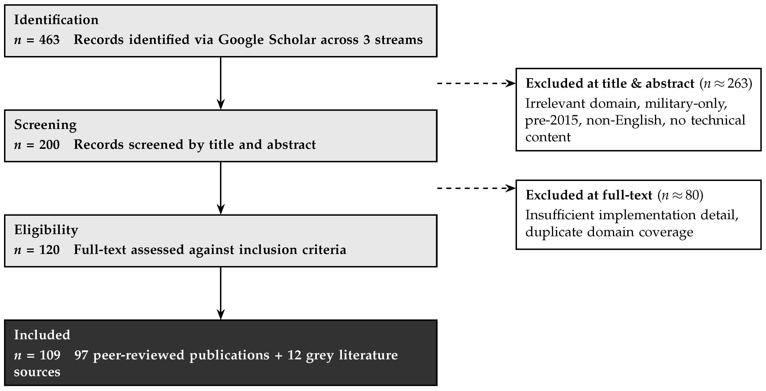
Selection followed a four-stage process: Identification, Screening, Eligibility Assessment, and Inclusion. Figure 1 illustrates the progression of records through each stage across all three streams.

2.8. Data Extraction Framework

A structured data extraction framework was applied consistently across all included papers. The variables extracted were defined per stream to reflect the different types of evidence synthesised in each section. This framework provides the methodological basis for the comparison tables presented throughout this paper (Table 3, Table 4 and Table 5).
Stream A—UAV Technology Papers:
Table 3. Data extraction variables for Stream A (UAV Technology Papers).
VariableDescription
Platform typeMultirotor configuration, fixed-wing, or hybrid VTOL
Payload capacityMaximum reported payload (kg)
Flight enduranceReported flight time under operational or near-operational conditions
SensorsType, weight, and spectral or spatial specifications
Control systemModel-based, model-free, or hybrid; specific algorithms employed
Autonomy levelManual, stabilised, waypoint navigation, or fully autonomous
Communication systemRF band, cellular (4G/5G), or satellite; operational range and latency
Key limitationsConstraints identified or reported by the authors
Stream B—Civil Application Papers:
Table 4. Data extraction variables for Stream B (Civil Application Papers).
VariableDescription
Application domainE.g., delivery, agriculture, inspection, emergency response, environmental monitoring
Flight parametersAltitude, speed, and coverage area specifications
PlatformUAV model or configuration deployed
Sensors/payloadSensing or operational equipment used in the study
Autonomy levelDegree of automation of the reported system
Key performance metricsAccuracy, coverage area, speed, cost, or domain-specific KPIs
Technical contributionWhat distinguishes the study from others in the same domain
Key limitationsReported constraints and open challenges
Stream C—Ethics and Regulatory Papers:
Table 5. Data extraction variables for Stream C (Ethics and Regulatory Papers).
VariableDescription
Jurisdiction/scopeGeographic or regulatory scope of the framework
Regulatory bodyE.g., FAA, EASA, or national authority
Ethical dimensionPrivacy, safety, environmental impact, or community relations
Compliance requirementsRegistration, certification, insurance, or remote identification
Practical guidanceActionable recommendations for UAV project planning

2.9. Methodological Reporting Standards in UAV Research

A recognised challenge in UAV research synthesis is the inconsistent reporting of methodological details across published studies, which limits replicability assessment and cross-study comparison. Barnas et al. [21] addressed this problem by developing a standardised protocol for reporting UAV methods in wildlife research, published in the Journal of Unmanned Vehicle Systems. While developed in a wildlife monitoring context, the protocol’s six reporting domains have direct relevance to UAV research across all application fields covered in this review.
The protocol structures required methodological disclosures to be split into six sections: (1) Project Overview, covering study objectives and UAV justification; (2) Drone System and Operation Details, including platform model, firmware version, mass, dimensions, and motor configuration; (3) Payload, Sensor, and Data Collection parameters, such as sensor model, spectral bands, resolution, frame rate, and triggering mode; (4) Field Operation Details, covering flight altitude, speed, overlap percentage, wind conditions, and temperature; (5) Data Post-Processing, specifying software used, point cloud density, georeferencing method, and accuracy metrics; and (6) Permits, Regulations, Training, and Logistics, documenting operator certification level, airspace authorisation, and insurance coverage.
The authors demonstrated through a systematic audit of the published drone studies that a substantial proportion omitted details across one or more of these categories—particularly sensor configuration parameters and post-processing specifications—preventing independent replication. This finding has direct implications for scoping reviews such as the present work: gaps in methodological reporting constrain the depth of technical synthesis achievable from the published literature, and future UAV research would benefit substantially from adopting standardised disclosure frameworks. This review applied the data extraction variables described in Section 2.8 to systematically capture the methodological details available in the included studies, acknowledging that incomplete reporting in some sources limited the specificity of comparisons made in subsequent sections.

3. Overview of Included Studies

This section provides a descriptive synthesis of the 109 sources included in this scoping review, analysing publication trends, geographic distribution, study design characteristics, and thematic coverage to contextualise the findings presented in subsequent sections.

3.1. Publication Trends

The temporal distribution of the included studies reveals significant growth in civilian UAV research following 2019. Of the 109 sources, 20 (18%) were published between 2015 and 2019, establishing foundational knowledge in platform engineering and early civil applications. The majority—88 sources (81%)—were published between 2020–2025, reflecting accelerated research activity driven by technological maturation and expanded deployment contexts.
Notable temporal patterns include:
  • 2020 surge: Pandemic-driven expansion in contactless delivery, remote monitoring, and emergency response applications.
  • 2021–2023: Concentration of research on artificial intelligence integration, swarm coordination, and 5G/cellular communication systems.
  • 2024–2025: Emergence of autonomy maturation studies, sustainability assessments, advanced regulatory frameworks, and 6G communication research.
This growth trajectory mirrors broader UAV commercialisation patterns, with research shifting from proof-of-concept demonstrations (2015–2019) to operational deployment optimisation and system integration (2020–2025).

3.2. Geographical Distribution

While there is global representation among the studies, three regions dominate the included literature, each with its own focus. Research outputs are dominated by these three regions:
  • North America (primarily United States): Around 35 % of studies, focusing on regulatory frameworks (FAA), delivery systems, and advanced autonomy.
  • Europe: Around 30% of studies, emphasising EASA regulatory harmonisation, privacy frameworks, and environmental applications.
  • East Asia (primarily China): Around 20% of studies, concentrating on swarm technologies, communication systems, and manufacturing innovation.
There is limited representation found from the following:
  • Africa: Sparse coverage beyond targeted case studies (e.g., malaria control drones in Zanzibar, wildlife monitoring).
  • Latin America: Minimal presence.
  • South Asia: Under-represented despite large potential markets.
  • Middle East: Some presence but not dominant. Regulatory and ethical discussions are particularly Western-centric, with limited investigation of developing-world deployment contexts, infrastructure constraints, or region-specific governance challenges.

3.3. Study Design Distribution

The 97 peer-reviewed sources comprise the following diverse methodological approaches:
Reviews and Surveys (30–35%): Comprehensive surveys addressing UAV technologies, AI integration, swarm systems, communication infrastructure, privacy concerns, and energy systems. These sources provided consolidated technical knowledge and identified research trajectories.
Case Studies and Field Deployments (20–25%): Operational implementations, including wildlife monitoring systems, mining applications, delivery pilots, wastewater monitoring, precision agriculture deployments, and COVID-19 response use cases. These sources documented real-world performance, operational constraints, and practical lessons.
Theoretical and Simulation Studies (25–30%): Algorithm development and modelling research addressing swarm consensus control, path planning optimisation, communication channel modelling, and regulatory compliance frameworks. These sources advanced theoretical foundations for autonomous operations.
Experimental and Controlled Testing (15–20%): Laboratory and field experiments evaluating propeller aerodynamics, wind impact on flight stability, battery performance under environmental stress, and sensor fusion validation. These sources provided empirical performance characterisation.
This methodological diversity reflects UAV research maturity, with established experimental foundations supporting increasingly sophisticated deployment investigations and theoretical advances.

3.4. Thematic Coverage

Thematic analysis reveals uneven research attention across UAV domains:

3.4.1. Dominant Research Areas

Autonomy, AI, and Control Systems (∼35% of corpus): The largest research cluster encompasses swarm coordination, path planning algorithms, reinforcement learning for decision-making, sensor fusion techniques, collision avoidance systems, and flight control architectures. This concentration reflects both technical complexity and critical importance for operational safety and capability advancement.
Communication and Network Integration (∼20%): Substantial attention to 5G/6G cellular connectivity, internet-of-drones architectures, multi-UAV communication protocols, and command-and-control relay systems, driven by beyond-visual-line-of-sight (BVLOS) operation requirements.
Environmental and Agricultural Applications (∼20%): Remote sensing methodologies, crop health monitoring, wildlife surveys, and waste management systems represent established application domains with mature deployment evidence.

3.4.2. Moderately Covered Areas

Infrastructure Inspection (∼10%): Building assessment, industrial facility monitoring, and automated inspection frameworks.
Delivery and Logistics (∼8%): Urban last-mile delivery, medical supply transport, and autonomous airdrop systems.

3.4.3. Under-Represented Areas

Insurance, Liability, and Economic Modelling (<5%): Limited rigorous cost–benefit analyses, lifecycle cost studies, or insurance framework development beyond delivery case examples.
Privacy and Ethical Frameworks (<5%): Minimal deep investigation despite significant societal concerns, with most sources providing high-level policy recommendations rather than empirical studies of privacy-preserving technologies or community impact assessments.
Human Perception and Social Acceptance (<3%): Sparse research on noise impact, community trust, or public acceptance determinants, despite these factors critically influencing deployment feasibility.
This distribution suggests research priorities favour technical capability advancement over economic viability, social acceptance, or ethical framework development—a pattern with implications for real-world deployment success and discussed in Section 7.

4. Drones and Their Properties

The terms used to describe these aircraft differ according to their implementation and context. Unmanned aerial vehicle (UAV) is the official technical term. UAVs are also widely referred to as “drones” in everyday speech [22]. Drones controlled by a remote pilot are known as Remotely Piloted Aircraft Systems (RPASs); Unmanned Combat Aerial Vehicles (UCAVs) are military combat drones; and Micro Aerial Vehicles (MAVs) are miniaturised platforms [23,24].
Structurally, UAVs are made up of four essential parts: the frame structure (platform), which influences flight characteristics, manoeuvrability, and mobility; the electromechanics, including hardware and sensors; the flight controller, which controls speed, stability, and other aspects of the drone; and the communication system, which handles communication across multiple bands [25,26,27,28].
Selecting appropriate components for a project fundamentally determines its operational capabilities and mission success [29]. This section examines each essential component and provides guidance for selecting configurations appropriate to specific objectives and operational constraints [28].

4.1. Platform Selection

Selecting an appropriate drone platform for a specific application requires careful consideration of several interdependent factors [22,24,28,30], including payload requirements (what sensors or equipment must be carried), mission duration and range (how long and how far the drone must operate) [3], operational environment (the terrain and weather conditions of the operational location) [22], and budget constraints [24,28]. Understanding these factors enables us to identify the platform that best meets our needs without over-investing in unnecessary capabilities [22]. This section provides guidance for making these decisions by examining the available platforms, their strengths, weaknesses, and the applications for which they are most commonly used.

4.1.1. Platform Configurations

Drone platforms are primarily categorised by their number of rotors, their rotor configurations, and whether they have fixed wings [22,25,31]. Because each category has distinct advantages and limitations, understanding these differences is essential for selecting the right platform.
Multi-Rotor UAVs
Multi-rotor platforms have multiple motors and achieve controlled flight through differential motor speeds [22,30], eliminating complex mechanics and enabling intuitive control [3]. Their vertical take-off and landing (VTOL) capability makes them ideal for deployment in confined areas [25], and their ability to hover enables stationary data collection, which is essential for many applications [32].
Quadcopters (four rotors) are optimal for most applications requiring lightweight sensing capabilities [22,31]. Their symmetric four-motor arrangement provides stability for photography, basic inspection, and preliminary site surveys [22]. With payload capacities between 1.5 and 2 kg [3,33] and typical flight times of 20–30 min [9], these platforms can support integrated RGB cameras (12–48 megapixel, 4 K–8 K video capability), small multispectral sensors, or lightweight sampling equipment. Their mechanical simplicity translates to lower acquisition costs [9], reduced maintenance requirements, and easier operator training [22]. Beyond standard quadcopter designs, recent work has investigated morphing structures that reshape the airframe mid-flight to enhance manoeuvrability and adaptability, though such configurations remain experimental [34]. However, quadcopters lack motor redundancy; a single motor failure typically results in loss of controlled flight [22,31], limiting their suitability for operations over sensitive areas or when carrying valuable equipment [22,23].
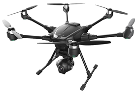
Hexacopters (six rotors) provide operational redundancy and extra payload capacity, which are essential when the objectives need more sophisticated sensing or when equipment value justifies additional investment [23,31]. Their six-motor configuration delivers more lifting power compared to quadcopters [3,33], accommodating payloads of about 4–6 kg [9]. A hexacopter can carry heavier sensors such as professional cameras, LiDAR sensors, larger multispectral systems, or agricultural sprayers. Hexacopters can maintain controlled flight with one motor failure [23,31] and can execute safe landings even with two motors inoperative [23], an essential capability when carrying expensive sensors or operating over areas where crashes could damage sensitive sites and equipment. This redundancy makes hexacopters the best choice for inspecting infrastructure (wind turbines, bridges, power lines), precision agriculture, and archaeological surveying, where equipment protection is paramount [23]. The trade-off involves higher costs [9], increased mechanical complexity, and higher power consumption, which reduces flight time [35] by 20–30% compared to quadcopters carrying similar payloads [9].
Octocopters (eight rotors) are necessary when applications demand maximum payload capacity [3,33] and the highest level of operational reliability [23,31]. The eight-motor configuration accommodates payloads of approximately 6–10 kg [9] and provides the smoothest flight characteristics and maximum redundancy [23,31]. These platforms can maintain flight with up to four inoperative motors [23]. Applications justifying octocopters typically involve carrying multiple synchronised sensors, heavy professional systems, or specialised equipment where mission failure would result in significant setbacks or financial losses [23]. Many octocopters have coaxial configurations (X8 or Y8 designs) where motors are vertically stacked on each arm, increasing thrust density while keeping the airframe size manageable. However, octocopters impose substantial operational overhead: empty weights often exceed 5 kg [23], significant power consumption reduces flight time [33,35] even with larger batteries, and their bulk size complicates field transportation and deployment. These platforms are best suited to well-funded projects requiring capabilities incompatible with lighter alternatives, such as large-scale 3D mapping with high-density LiDAR, critical infrastructure inspection with multiple sensor modalities, or environmental monitoring requiring simultaneous thermal, multispectral, and high-resolution visual sensing [36].
Alternative Platform Configurations
Fixed-wing UAVs feature a conventional aircraft wing system that generates lift through forward motion over stationary wings rather than rotor thrust [22,25,37]. This approach provides superior energy efficiency [30,35], enabling flight times of 60–120 min [10] and operational ranges exceeding 50 km [36], three to five times greater than comparable multi-rotor platforms [30]. Fixed-wing drones excel in applications requiring large-area coverage such as mapping agricultural fields (hundreds of hectares per flight) [30], pipeline or transmission line inspection (linear infrastructure spanning tens of kilometres) [36], coastal surveying, and wildlife habitat assessment. The efficiency advantage of fixed-wing drones stems from their ability to cruise, making them ideal when requiring coverage over large areas rather than stationary data [22].
However, fixed-wing UAVs require runways or launch catapults for take-off and a suitable area for landing [25], limiting usability in small, confined spaces or urban environments where obstacles and movements are present [22]. They must also maintain a minimum airspeed to remain aloft [30], which prevents hovering for detailed inspections or precise positioning over specific features.
Hybrid VTOL (Vertical Take-Off and Landing) platforms represent an engineering advancement merging the deployment convenience of multi-rotor VTOL with the efficiency of fixed-wing cruise flight [25,37]. They use dedicated vertical-lift rotors for take-off and landing, then transition to efficient fixed-wing cruise flight for range and endurance [23]. This dual-mode capability enables deployment in confined areas while achieving the range and efficiency necessary for long-distance missions [23]. Hybrid VTOLs are well suited for applications such as extended coastal monitoring [38], large-area geological surveys, and wildlife tracking, where both launch flexibility and endurance are required.
Current hybrid VTOL designs range from quad planes to sophisticated tilt-wing systems where the entire wing assembly rotates for mode transition [25]. However, the additional weight of having multi-rotors for vertical-lift and cruise propulsion systems adds more weight and complexity, which cancels out some of the gains in efficiency [39]. These platforms also cost 2–3 times more compared to similar fixed-wing or multi-rotor alternatives [11] and require more sophisticated operator training [40]. A hybrid VTOL is most logical for applications where both capabilities are essential and the operational advantages justify the additional complexity and investment [37].
Selecting the right platform begins with clearly defining requirements across the following four key criteria:
1.
Payload Requirements: Identify all sensors, equipment, and samples that must be carried simultaneously. Combine their weights and add a 20–30% margin for mounting hardware and cables. Consider physical dimensions as well—some sensors may require specific orientations or additional space, which may necessitate a larger UAV.
Drone Payload Capacity ( W s + W e + W sample ) × 1.3
where W s , W e , W sample are the weights of the sensors, equipment, and sample, respectively.
2.
Mission Profile: Determine application requirements:
  • Stationary observation (inspecting structures) → multi-rotor;
  • Area coverage (mapping fields) → fixed-wing or hybrid VTOL;
  • Linear infrastructure (pipelines, roads, coastlines) → fixed-wing;
  • Confined deployment (forest clearings, urban sites, ships) → multi-rotor or hybrid VTOL.
3.
Operational Range and Endurance: Calculate required flight time, including transit to/from the deployment area, data collection time, and a 20–30% reserve for return-to-home contingency. If required endurance exceeds 30 min with payload, consider fixed-wing platforms or plan battery swaps.
Total Required Endurance ( T t + T d ) × 1.25
where T t = Transit time (round trip) = 2 × ( Distance to site ÷ Cruise speed ) ; T d = Data collection time; and the factor 1.25 represents a 25% reserve (midpoint of 20–30%).
4.
Risk Tolerance and Budget: Assess the consequences of equipment loss:
  • Integrated consumer cameras → Quadcopter acceptable
  • $5000–$15,000 sensor value → Hexacopter redundancy justified
  • >$20,000 sensor value → Octocopter redundancy essential
Table 6 shows the multi-rotor configurations and their images.
A side-by-side assessment of various airframe designs is provided in Table 7.

4.2. Electromechanics

4.2.1. Flight Endurance and Battery

Battery energy density remains the primary constraint limiting drone operations [28,30]. Current lithium-polymer (LiPo) batteries store approximately 150–250 Wh/kg [12], far below aviation gasoline at ∼12,000 Wh/kg [30]. This restricts flight times for consumer quadcopters despite optimised aerodynamics and power management. Understanding the factors affecting flight time and endurance supports realistic mission planning [28]:
Platform efficiency: Flight time and endurance depend substantially on the drone platform [32,41], including propeller diameter (larger propellers are generally more efficient), aerodynamic optimisation, and the ability to cruise. Forward flight at optimal cruise speed consumes less power than hovering [30].
Mission profile: Hovering for stationary observation, aggressive manoeuvring, and high-speed flight can reduce flight time substantially [22,32,35]. Flight time should therefore be evaluated in the context of the specific mission profile rather than as a fixed universal value.
Environmental factors significantly affect performance [28,42,43]: Cold temperatures (<10 °C) reduce battery capacity [42]; strong wind increases power consumption [43]; and high-altitude operations reduce air density, requiring a higher propeller RPM for equivalent thrust.
Most professional drones reserve 10–20% battery capacity as emergency return-to-home power—an essential safety margin that reduces usable flight time. Accordingly, missions should be planned using no more than 70% of battery capacity to account for real-world conditions and safety reserves [12,35]. Manufacturer-advertised maximum flight times are typically achieved under optimal laboratory conditions; operational flight times are generally shorter [35].
The battery capacity required for a mission can be estimated as
E battery P hover · t hover + P cruise · t cruise + P maneuver · t maneuver × F env 0.7
F env = F temp × F wind × F altitude
where E battery = total battery capacity needed (Wh); P hover = power consumption while hovering (W); t hover = time spent hovering (h); P cruise = power consumption during cruise flight (W); t cruise = time spent in cruise flight (h); P maneuver = power consumption during manoeuvring (W); t maneuver = time spent manoeuvring (h); F env = environmental factor (multiplier for temperature, wind, and altitude effects); 0.7 = safety factor (use only 70% of battery capacity); F temp = temperature factor; F wind = wind factor; and F altitude = altitude factor.
Practical strategies for extended operations:
  • Battery swapping infrastructure: Rather than waiting 60–90 min for recharging, maintain multiple batteries (3–5 for full-day operations) and rotate through charging cycles. In-flight battery swapping systems can also extend mission continuity without requiring landing.
  • Solar charging stations: For multi-day remote deployments, portable solar panels enable field battery recharging, eliminating the need to return to base.
  • Mission segmentation: Design optimal data collection patterns to minimise transit time and maximise observation time.

4.2.2. Sensors

Sensor selection fundamentally determines data quality, research capabilities, and platform requirements. This section examines common sensor types and their capabilities, applications, and limitations. Table 8 summarizes how different sensors compare in weight, primary uses, and key drawbacks.

4.3. Flight Control and Autonomy

Modern flight controllers integrate multiple sensors and incorporate autonomous capabilities for reliable operations across diverse environments [28,30]. Understanding these systems supports selection of appropriate platforms and autonomy levels for a given application.

4.3.1. Sensor Fusion

Flight controllers achieve stable flight by fusing data from complementary sensors, each compensating for the limitations of others [23]:
Inertial Measurement Units (IMUs) measure orientation and motion at high rates (100–1000 Hz) [23], typically with dual or triple redundancy for reliability [30]. IMUs are precise over short durations, but errors accumulate over time without external corrections [44].
GNSS Receivers (GPS) provide absolute positioning accurate to 5 m, which is sufficient for general operations [25,30]. Real-Time Kinematic (RTK) systems achieve centimetre-level precision through differential corrections from ground base stations [45], which is essential for applications requiring high precision such as precision agriculture and detailed surveying. RTK adds additional cost and operational complexity [45].
Barometric Altimeters measure altitude using atmospheric pressure with approximately 0.5 m accuracy [30,35]. Their limitation is susceptibility to weather-induced pressure variations [46].
Obstacle Avoidance Systems use cameras or range sensors with 360° coverage for autonomous collision avoidance in cluttered environments [22]. This capability is critical for missions in forest, industrial facility, or urban environments, but is unnecessary for open-area operations [22].

4.3.2. Control System Approaches

Model-Based Control uses mathematical models of aircraft dynamics to calculate desired responses from sensor inputs [3,28]. The flight controller then issues a series of commands enabling the UAV to achieve the desired position. Examples include six-state altitude models for smooth climb and descent [3], complementary sensor fusion incorporating IMU and GNSS for accurate positioning, adaptive sliding mode control for adjusting to unexpected wind and payload variations [23], and model predictive control for optimised path planning. Model-based approaches provide predictable and reliable performance suitable for applications requiring precise control such as photogrammetry [3]. Performance degrades when unexpected factors occur (aerodynamic interactions near structures, asymmetric payloads) [23,28].
Model-Free Control learns appropriate responses without explicit models using either fuzzy logic (simple “if–then” rules mimicking human control) [23], which is optimal for very few applications, artificial neural networks (learning patterns from training data), or deep reinforcement learning (DDPG, TD3 algorithms) [37]. These methods offer adaptability to changing conditions and the potential for solving complex tasks, but require greater computational resources and lack certification pathways for most applications [3]. As such, these techniques remain primarily research tools rather than production-ready solutions.

4.3.3. Autonomy Levels and Selection

Manual/Stabilised Control: The drone is controlled directly by a pilot. This is suitable for operations requiring rapid response or when regulations mandate manual flight, such as in search-and-rescue missions [25,30], disaster response, and operations in obstacle-ridden areas [22].
GPS Position Hold: Automatically maintains 3D position. This is the most common mode for stable data collection including photography, video capture, and stationary sensor observations [22].
Waypoint Navigation: Executes pre-programmed flight paths with automated actions [22]. Mission planning software (DJI Ground Station Pro: 2.0.11, UgCS: 3.3, Mission Planner: 1.3.74) is used for this purpose. This capability is essential for repeatable operations with identical flight paths across temporal studies including perimeter security patrols, power line and pipeline inspection, and automated delivery routes.
Intelligent Tracking: Uses computer vision algorithms to automatically follow a subject. This approach is valuable in monitoring wildlife and tracking dynamic targets. In this method, performance may degrade in cluttered and complex environments [22].

4.4. Communication Systems

4.4.1. Command and Control Links

Reliable communication between the ground station and the drone is fundamental for safe and effective operations [30]. Most modern UAVs use radio frequency technologies on 2.4 GHz and/or 5.8 GHz ISM bands for communication [22,25,27]. Radio frequency communication provides a range of 5–15 km while maintaining video links and telemetry [47]. The 2.4 GHz band is the most common, offering better range and obstacle penetration but facing interference from WiFi and Bluetooth devices [26,27]. The 5.8 GHz band provides less interference at the cost of reduced range, especially in dense environments [27]. Systems such as DJI’s OcuSync and Autel’s SkyLink use a frequency-hopping spread spectrum and dual-band operation, achieving more secure transmission with 7–15 km ranges and full HD video transmission [48].
Cellular connectivity is also an emerging option for communication that uses standard mobile networks [47,49,50]. This method offers extended range beyond radio capabilities [50]. However, cellular latency (50–200 ms) exceeds direct radio links (5–30 ms), making it more suitable for supervisory control of autonomous missions [47]. The introduction of 5G networks introduced a latency of 10 ms, which is similar or even superior to radio, enabling remote piloting and collaborative multi-drone missions [49,50]. Satellite communications remain experimental due to cost, weight, and latency constraints, though emerging low-Earth-orbit constellations may eventually enable operations in remote regions [51].

4.4.2. Multi-UAV Coordination

Multi-UAV systems enable capabilities unavailable on a single platform [23,24,25]. They allow simultaneous multi-angle observation, coordinated area coverage, and distributed task execution [23,25]. Effective coordination requires each drone to maintain self-awareness (position, orientation, battery status, system health) as well as group awareness (positions and intentions of other team members) [23,25], and this is possible through continuous communication and information exchange, preventing collisions and enabling dynamic task reallocation [25].
Furthermore, Multi-UAV systems use either centralised control, where a ground station coordinates all activities as well as computes task allocation [24], or distributed approaches, where UAVs coordinate peer-to-peer with minimal ground intervention using consensus algorithms [23,25,37]. Distributed architectures prove to be more resilient to communication failures and scale better with larger swarms [23]. However, distributed systems require each drone to have more powerful onboard computers for sophisticated real-time processing [23].
Common coordination frameworks include the Robot Operating System (ROS) with multi-agent extensions [52], the PX4 autopilot stack with swarm support, and specialised platforms such as ArduPilot’s multi-vehicle capabilities [52]. Coordination algorithms address task assignment, trajectory planning, and collision avoidance simultaneously [23,37].

5. Civil Applications

The integration of UAVs into civilian sectors has transformed traditional practices across several domains including delivery and logistics, infrastructure monitoring and management, environmental monitoring, emergency response, and creative applications. Drones have demonstrated significant improvements in efficiency, safety, and cost when compared to conventional methods. This section reviews UAV applications across major civilian sectors, focusing on the technical specifications and the operational frameworks used in practice. Across these domains, a consistent pattern emerges: multirotor platforms dominate applications requiring precise positioning and stationary observation, while fixed-wing systems are preferred where large-area coverage and endurance take priority. Sensor selection and autonomy requirements also differ substantially by domain, as detailed in the subsections below.

5.1. Delivery and Logistics Systems

Urban logistics face mounting challenges spanning e-commerce expansion, traffic congestion, and environmental sustainability requirements. UAV-based delivery systems address these constraints by operating in three-dimensional airspace, bypassing ground traffic while reducing carbon emissions through electric propulsion. Research efforts have focused on optimisation of operational parameters, infrastructure requirements, and the economic viability for last-mile delivery networks.

5.1.1. Last-Mile Urban Delivery

Borghetti et al. [53] investigated the efficacy of UAV last-mile delivery in congested, urban areas in Milan using two practical methods: depot-based systems and mobile van depots with charging capabilities. For consecutive delivery strategies, the authors found that mobile van depots returned the maximum number of operations. The proposed system included octocopter platforms with 15 km flight radius, 45 min cycle times including battery changes, 5 kg maximum payload capacity, and 18 daily deliveries per drone. Key challenges were in routing optimisation, assignment algorithms, charging infrastructure allocations, and collision avoidance (with people and objects).
A Survey Plan (SP) approach was implemented to estimate demand through user decision-making simulation to evaluate adoption of drone delivery. The survey compared delivery vehicles including vans, bicycles, scooters, and drones based on factors such as cost, time, and asset value. Muscle-powered bicycles and electrically powered drones were identified as the only sustainable options, with drones offering greater speed than bicycles.
For the Milan-scale deployment, the authors suggested that four carefully placed depots, accommodating 240 drones, be strategically spread out throughout the city, and that drones would be flying fifteen kilometres in 45 min cycles to complete eighteen missions between 8:00 am and 9:15 pm. Due to weather conditions, operations would be restricted to approximately 20 days per year, affecting 350,000 packages. Despite these limitations, the investment is projected to become profitable within three years, with an estimated revenue of €3.75 per drone delivery.

5.1.2. Autonomous Decision-Making and Airdrop Operations

Li et al. [5] advanced autonomous delivery capabilities through the development of a manoeuvre decision-making model for autonomous airdrop tasks using Deep Deterministic Policy Gradient with Prioritised Experience Replay (PER-DDPG). The model optimised flight state (current state), flight actions (commands to execute), and flight assessment functions (score on how good/bad the action was) to maximise performance reward through past experience replay and soft parameter updating. Their simulation results demonstrated that PER-DDPG outperformed standard UER-DDPG in resolving turn-around and navigational challenges while improving UAV autonomy during airdrop operations, demonstrating an advancement in complex decision-making scenarios for delivery applications.

5.1.3. Medical Supply and Emergency Delivery

Medical supply delivery has emerged as a critical UAV application, with numerous studies documenting its successful implementations across diverse geographic settings. Pavithran et al. [54] developed a fixed-wing UAV prototype specifically optimised for medical supply delivery in rural areas. The system is projected to address traffic congestion, inadequate road infrastructure, and time-critical constraints affecting patient outcomes. Their system was built upon a NACA 63-412 airfoil platform with a 1.5 m wingspan and aspect ratio of 7, achieving a 5 km operational range with 30 min flight endurance at 350 feet altitude. The UAV measures 1.0 × 0.12 × 0.10 m, housing a 700 g payload bay, and is propelled by an 850 KV brushless DC motor with an 11 × 4.5 -inch propeller powered by a 6500 mAh four-cell lithium polymer battery. The autonomous system integrates a Pixhawk flight controller with a GPS module, pitot-static tube for airspeed measurement, 433 MHz telemetry for ground station communication, and PPM encoder supporting manual, stability-augmented, and fully autonomous waypoint navigation modes. The parachute recovery system includes a hemispherical nylon canopy designed for a 3 m per second descent rate. The drone requires a 200 m runway length for operations while maintaining a 2.3 kg gross take-off weight. An overview of different drone-based logistics applications is given in Table 9.

5.2. Infrastructure Inspection and Monitoring

One of the most established UAV applications lies in infrastructure inspection, with systems regularly deployed for building assessment and industrial facility monitoring. However, costly traditional inspection methods require machinery such as scaffolding and cranes and may place human workers in hazardous situations. UAV platforms effectively mitigate safety risks and high operational costs.

5.2.1. Automated Building Inspection

Huang et al. [55] developed the following five-step Building Information Modelling (BIM) process for automated exterior building surface inspection: representing BIM data as a cloud surface model, determining viewpoint (starting position), path planning and optimisation, virtual simulation validation, and actual flight execution. To accommodate various building complexities, their methodology implemented basic and advanced path planning functions. The basic function automatically generated flight paths covering complete building exteriors coupled with integrated obstacle avoidance algorithms, whereas the advanced function decomposed complex buildings into manageable segments using a four-step segmentation process. This enabled error-free handling of complicated building geometries alongside improved efficiency. Validation was done using Microsoft AirSim across various building contexts and environmental conditions prior to deployment. The results demonstrated that BIM-enabled path planning successfully directed UAVs in systematic building inspections.

5.2.2. Advanced Industrial Inspection and Maintenance with Aerial Manipulation

Ollero et al. [56] introduced the AEROARMS project, tackling limitations in industrial inspection and maintenance where traditional methods require human workers to complete inspections in hazardous locations or rely on expensive specialised equipment with restricted operational flexibility. The researchers developed four distinct aerial manipulator configurations optimised for different industrial tasks. The first and second platforms used a hexacopter and an octocopter respectively with a rigidly attached end-effector arm for simple operations. Advanced configurations included dual-arm manipulators with either stiff or compliant joints, where one arm was used for grasping the infrastructure while the other performed the required task. The control system addressed interaction force management for safe contact with industrial structures without damaging equipment or destabilising flight. The operation system used passivity-based control to balance stability and responsiveness while compensating for communication delays between the ground operator and the drone. Experimental validation in outdoor industrial settings demonstrated successful autonomous contact operations withstanding perturbations up to 100 Newtons while maintaining low position estimation errors, providing the robustness needed for real-world applications. Table 10 shows two representative infrastructure inspection use cases with their platforms, sensors, and key innovations.

5.3. Agricultural Applications

Precision agriculture has become one of the primary beneficiaries of UAV technology, with platforms enabling spatially resolved crop monitoring, targeted interventions, and resource optimisation improving yields while reducing environmental impacts. Furthermore, the integration of specialised sensors with autonomous flight capabilities transforms traditional farming practices through data-driven decision-making. Mogili and Deepak [7] provide a broad overview of drone applications in precision agriculture, including crop monitoring and pesticide spraying, highlighting how UAVs can cover hectares of fields in a single flight and reduce human health risks associated with manual pesticide application.

5.3.1. Thermal Remote Sensing for Irrigation Optimisation

Sharma et al. [57] conducted a comprehensive review of UAV-based remote sensing techniques for detecting water stress in specialty crops. The timely detection of water stress identifies irrigation needs, leading to improved crop yield quality and a reduction in water wastage. Their study analysed 104 scholarly articles from 2012 to 2024, examining thermal, multispectral, and hyperspectral imaging systems, sensor specifications, flight parameters, and data processing algorithms across vineyards, orchards, and vegetable crops to identify best practices in water stress monitoring.
The Crop Water Stress Index (CWSI) was identified as the most widely used thermal indicator for crop water stress. CWSI compares canopy temperature with air temperature, with adjustments for humidity and vapour pressure deficit. Drones with thermal sensors operating in the 8–14 micrometre wavelength range, with spatial resolutions between a few centimetres (high detail) and 50 cm (lower detail) flying at various altitudes above crops, allowed accurate thermal imaging for crop water stress detection. Combining thermal data with multispectral images (particularly SWIR bands at 1450 nm and 1940 nm) identified water stress with accuracies exceeding 85% ( R 2 values ranging from 0.77 to 0.92). Key challenges included atmospheric effects on thermal images, canopy heterogeneity and shadow interference, processing large amounts of high-resolution hyperspectral data, payload constraints, and scalability limitations for large-scale agricultural monitoring.

5.3.2. Crop Monitoring and Yield Estimation

Sapkota and Paudyal [58] explored the capability of UAVs for maize plant growth monitoring and yield estimation in the mountainous terrain of Nepal. Their study aimed to use drones for rapid examination of plant growth patterns and yield prediction across large areas. A multirotor UAV equipped with a multispectral camera was used to capture the spectral information of the maize plants throughout the plant’s life cycle. The captured images were then combined to create an orthomosaic map and a 3D model of the field in order to estimate yield based on the following factors: plant height, vegetation indices (GRVI and NDVI), Leaf Area Index (LAI), and biomass measurements. The findings demonstrated that drone-captured images are superior to lower-resolution satellite images in yield prediction, especially in complex mountainous terrain.

5.3.3. Forest Disease Detection

Qin et al. [59] developed the Spatial-Context-Attention Network (SCANet), a deep learning technique for automatic pine wood disease detection using UAV remote sensing images. Conventional spectral-data-only techniques fail for small targets with complex backgrounds. SCANet integrates spatial information retention modules, context information modules, and attention refining modules to capture both high-level and low-level features, reduce information loss, increase receptive fields, minimise background interference, and highlight target features. This method achieved an overall accuracy of 79.33% with 0.86 precision and 0.91 recall, outperforming previous machine learning and deep learning techniques.

5.3.4. Swarm-Based Agricultural Monitoring

Albani et al. [60] developed a swarm robotics approach for autonomous weed monitoring and mapping in agricultural fields, specifically targeting volunteer potato detection in sugar beet cultivation. The SAGA (Swarm Robotics for Agricultural Applications) project proposed a decentralised multi-UAV system where collective behaviour emerges from self-organisation rather than centralised control, providing flexibility, scalability, and robustness. The approach took inspiration from the collective decision-making observed among foraging honeybees, enabling UAVs to dynamically allocate resources to weed-dense areas while swiftly abandoning weed-free areas through peer-to-peer interactions and consensus-based field categorisation.
The system architecture integrated PrecisionScout quadcopters (30 min flight time) equipped with triple-redundant autopilots, five IMUs, RTK-GPS for centimetre-level positioning, RGB cameras, and Nvidia Jetson processors for onboard vision and control. Ultra-Wideband (UWB) technology provided inter-UAV communication and relative localisation. The weed detection system employed a convolutional neural network for semantic segmentation of sugar beets versus volunteer potatoes. Collaborative re-sampling across multiple drones improved detection accuracy compared to relying on individual platform precision. The results demonstrated that patchy weed distributions significantly reduced monitoring time compared to uniform distributions, validating the resource allocation strategy. Table 11 shows several drone-assisted agricultural monitoring techniques along with their sensor configurations and performance metrics.

5.4. Summary of Environmental and Conservation Applications

UAV technology has transformed ecological research and conservation efforts by enabling non-invasive monitoring, comprehensive spatial coverage, and access to previously inaccessible terrain. Applications span ecosystem restoration, wildlife population surveys, habitat assessment, and environmental health monitoring. Across these applications, a consistent pattern emerges: multirotor platforms are preferred for localised, high-resolution tasks (e.g., coral reef mapping, water sampling), while fixed-wing and hybrid VTOL systems are more appropriate for large-area habitat surveys and fishery monitoring. Manfreda et al. [61] provide a comprehensive framework for UAV use in environmental monitoring, demonstrating the versatility of UAS platforms across hydrological, ecological, and land-surface applications. Similarly, Ventura et al. [62] document UAS applications in coastal habitat monitoring, demonstrating the effective mapping of seagrass meadows and benthic communities. Guan et al. [63] further establish best practices for small UAS (sUAS) monitoring of coastal environments, covering field protocols, sensor calibration, and data processing standards that are directly applicable to practitioners initiating environmental monitoring projects.

5.4.1. Ecological Monitoring, Maintenance, and Restoration

Robinson et al. [64] examined UAV applications in ecological monitoring, maintenance, and restoration. They proposed the introduction of drones within the Society for Ecological Restoration (SER) Recovery Wheel to simplify traditionally complex and time-consuming measurements. Their study divides drone use cases into three stages: planning, implementation, and monitoring.
1.
Planning Phase: Compared to satellite imagery, drone-based vegetation mapping produces more affordable and higher-resolution topographic maps. In one study, the authors used a commercial UAV DJI Phantom 4 to create detailed shallow coral reef orthomosaic images. UAVs fitted with LiDAR for measuring ecosystem structural characteristics produced more accurate results, with further improvements when combined with machine learning algorithms. Choosing the right platform for the use case was proven to be the first necessary stage.
2.
Implementation Phase: Field deployments in the UAE and Thailand find up to 20% survival rates for drone-planted seeds. Even with these modest rates, UAVs are advantageous for regions humans cannot easily reach. Multirotor UAVs with sprayers have also been effectively used to apply agricultural pesticides in alfalfa production and insect pest control applications, and drones with thermal detectors are used to combat wildfires particularly in early detection of wildfires. The real-time transmission of data guides firefighters to drop extinguishing balls to control fires before further spread.
3.
Monitoring Phase: Drones monitoring vegetation health enable scientists to track ecosystem changes and adapt management and restoration strategies accordingly. Wildlife surveillance is enhanced using real-time video or infrared sensors for animal detection. UAVs equipped with landing gear and sampling tools can gather environmental DNA (eDNA) or Polymerase Chain Reaction (PCR) samples, providing detailed ecological community data. Air-sampling drones measure air quality to evaluate whether ecosystem restoration interventions such as reforestation are needed.
Barnas et al. [21] address the need for methodological standardisation in UAV-based wildlife research, proposing a standardised protocol for reporting drone survey methods. Their framework covers flight parameters, platform specifications, and data collection procedures, and is particularly valuable for ensuring reproducibility and comparability across studies—a dimension this review identifies as an important gap in the current literature.
Singh et al. [65] present a systematic review and best-practice guidelines for drone remote sensing of invasive plants, demonstrating how workflow design, sensor selection, and classification algorithms together determine detection accuracy. Their findings are applicable across environmental monitoring domains where species-level discrimination is required.

5.4.2. Fishery Research and Aquatic Monitoring

Harris et al. [66] noted that there is a lag in adoption of Unmanned Aircraft System (UAS) technology in fishery research. While traditional methods using satellite, aircraft, and boats are good, drones perform the same tasks more cost-effectively and efficiently. In particular, drones may be used in fisheries as an enhanced resource monitoring tool and as an aid in preventing illegal fishing. In this research, multirotor UAS platforms with a battery life of 20–40 min were employed to document sockeye salmon monitoring in Alaska and Red Drum observations in Florida, estimating biomass and observing fish behaviour for efficient harvesting. Their research also documented habitat mapping applications, including near-infrared hyperspatial imagery to detect vegetation and water content, digital surface model generation with survey-grade elevation values to create detailed 3D models of the ground and surrounding objects, and normalised difference vegetation index (NDVI) calculations to measure plant health. Table 12 shows drone-based use cases across several ecological monitoring and conservation domains.

5.4.3. Sensor Selection and Operational Workflows for Environmental Monitoring

Manfreda et al. [61] provided a comprehensive review of UAS applications in environmental monitoring, representing a foundational synthesis developed within the HARMONIOUS COST Action network involving scientists from 30 countries. Their study examined UAS deployments across hydrological monitoring, natural and agricultural ecosystem assessment, and river system characterisation, with particular attention to sensor selection, workflow design, and data quality constraints.
On the sensor side, the review catalogued optical cameras in full-frame and APS-C configurations for high-resolution photogrammetry, multispectral cameras for vegetation indices and water quality proxies, hyperspectral sensors for mineralogical and biochemical analysis, thermal cameras for evapotranspiration and surface energy balance estimation, and LiDAR for topographic and structural characterisation. The authors emphasised that sensor selection must balance spatial resolution requirements, platform payload limits, the spectral range of interest, and processing complexity—a multi-criteria decision not reducible to a single optimal choice.
Operationally, the review formalised a seven-stage UAS data collection workflow: (1) mission and flight planning; (2) pre-flight camera or sensor configuration; (3) in-flight data collection; (4) ground control and radiometric calibration; (5) geometric and atmospheric correction; (6) orthorectification and image mosaicking; and (7) extraction of application-relevant products and metrics. Ground Control Points (GCPs) were identified as essential for achieving sub-decimetre georeferencing accuracy in photogrammetric products, with direct georeferencing using RTK-GNSS reducing but not eliminating GCP dependency in high-accuracy applications such as flood inundation mapping or stream channel morphology characterisation.
Key operational challenges documented included spatiotemporal constraint mismatches between UAS revisit capacity and ecological process dynamics, payload limitations restricting simultaneous multi-sensor deployments on small platforms, and the absence of harmonised data quality and reporting standards preventing cross-study comparison. The review explicitly identified standardisation of acquisition protocols and data products as a priority for advancing UAS environmental monitoring from individual case studies toward systematic, reproducible monitoring programmes.

5.5. Emergency Response and Healthcare

Medical drone applications represent critical time-sensitive deployments where rapid response capabilities directly impact patient outcomes and survival rates. Systems have been developed for emergency medical supply delivery, disaster response coordination, pandemic monitoring, and telemedicine support. Daud et al. [6] provide a scoping review of drone applications in disaster management, documenting their use across search and rescue, medical supply delivery, damage assessment, and communication relay roles, and confirming the versatility of UAV platforms across emergency contexts.

5.5.1. Invasive Plant Species Detection and Best Practices for Drone Remote Sensing

Singh et al. [65] conducted a systematic review of drone-based remote sensing for invasive plant detection and mapping, synthesising 103 studies published between 1960 and 2023 using a database of 33 standardised reporting parameters. The review covered image capture approaches, data processing pipelines, analytical methods, and species–ecosystem suitability, providing both a technical synthesis and a set of best practice recommendations directly applicable to environmental monitoring projects.
On the sensor side, RGB cameras dominated the reviewed literature due to their low cost and ease of use, but were found limited to morphological and colour-based discrimination, which failed for species with visually similar phenotypes or at early growth stages. Multispectral sensors operating across red-edge and near-infrared bands enabled computation of vegetation indices such as NDVI, NDRE, and EVI, improving discrimination accuracy for species with distinct chlorophyll or water content signatures. Hyperspectral sensors provided the highest discriminatory power, enabling detection of biochemical markers unique to invasive taxa, but imposed significant weight penalties (1–5 kg) and generated data volumes requiring specialised processing pipelines. Flight altitude directly influenced the trade-off between spatial resolution and area coverage: low-altitude flights (10–30 m AGL) produced centimetre-resolution imagery suitable for individual plant identification, while higher altitudes (60–120 m) balanced resolution with coverage efficiency for landscape-scale surveys.
For image processing, the review documented progression from traditional supervised classifiers (Random Forest, Support Vector Machine) to deep learning approaches including convolutional neural networks (CNNs) and semantic segmentation models (U-Net, DeepLabV3+), with the latter achieving precision and recall values consistently above 85% for well-trained species-specific models. Object-Based Image Analysis (OBIA) was identified as particularly effective for mapping clonal invasive species with distinctive canopy textures. A key finding was that most studies focused on a single site (74%) and single species (68%), raising concerns about the generalisability of trained models across geographic regions, seasonal conditions, and habitat types.
The study’s best practice recommendations included specifying sensor model, spectral bands, and calibration procedure in all published work; reporting flight altitude, overlap percentage (recommended ≥80% front and ≥60% side), and Ground Sampling Distance; selecting sensor type based on the spectral distinctiveness of the target species rather than cost alone; and validating detection models on independent datasets from spatially distinct sites before operational deployment. The authors further identified the Global South as substantially under-represented in the existing evidence base—a pattern consistent with the geographic bias documented in the present review—and called for prioritising invasive species drone monitoring research in tropical and subtropical ecosystems where biological invasion pressure is highest.

5.5.2. Pandemic Response and Surveillance Systems

Multiple frameworks addressing pandemic and epidemic response using UAV technology have been developed. Gupta and Bansal [67] reviewed the use of drones as a technological response to the COVID-19 epidemic in surveillance and monitoring, drug and supply delivery, and post-epidemic analysis. Different drone types were used for different tasks: multirotor drones for close-range tasks such as aerial photography and crowd monitoring, and fixed-wing drones for large-area mapping and long-endurance surveillance. Blockchain BloCoV6 schemes were introduced for health data sharing, ensuring data integrity. 5G communication was integrated to enable real-time video and sensor data transmission. Doppler sensors and onboard cameras were used to detect human movement and crowd density, supporting social distancing. Geographic Information Systems (GIS) supported spatial analysis by mapping infection hotspots and optimising drone routes. Deep learning models, including CNNs and DNNs, were employed for automated face mask detection, crowd counting, and anomaly detection.

5.5.3. Humanitarian Aid and Disaster Response

Allen and Mazumder [68] proposed an integrated autonomous system for disaster response through AASAPS-HADR (Autonomous Aerial Survey and Planning System for Humanitarian Aid and Disaster Response), addressing gaps in how emergency services assess and respond to natural disasters. The framework consisted of networked ground stations and autonomous quadrotor UAVs operating through an emergency ad hoc communication system. AI perception algorithms were used for three critical tasks: assessing road damage to determine passable routes, detecting and geolocating human victims in affected areas, and performing health assessments to prioritise medical response. Experimental validation used the Nvidia Jetson TX2 embedded computing platform mounted on quadrotor UAVs running real-time pose recognition algorithms for non-contact health monitoring. The system architecture included autonomous navigation capabilities for surveying entire disaster zones, machine learning models for victim identification and casualty classification, and route optimisation algorithms generating dispatch plans for ground-based emergency vehicles.
Daud et al. [6] conducted a scoping review examining UAV deployments across disaster management phases using Arksey and O’Malley’s framework updated by the Joanna Briggs Institute for Scoping Reviews. The review synthesised evidence across four operational phases, namely mitigation, preparedness, response, and recovery, covering applications ranging from pre-disaster risk mapping to post-disaster damage assessment and victim search.
In the response phase, multirotor platforms equipped with RGB and thermal cameras were the dominant configurations, used for real-time situational awareness, survivor detection in collapsed structures, and delivery of emergency supplies to areas inaccessible by ground teams. Fixed-wing platforms were deployed for large-scale mapping operations due to their superior endurance, enabling rapid generation of updated terrain models following floods, earthquakes, or landslides. LiDAR-equipped UAVs produced three-dimensional structural damage assessments, while multispectral sensors evaluated post-flood vegetation loss and soil contamination. Communication relay applications were also documented, where UAVs extended ground-to-rescue-team connectivity in GPS-degraded or infrastructure-destroyed environments.
The review identified critical operational limitations, including battery endurance constraining sustained search coverage, regulatory clearances delaying deployment in active disaster zones, and the absence of standardised data formats limiting interoperability between multi-agency response systems. The authors further noted a geographic bias toward developed-country disaster contexts, with limited evidence from low-resource settings where UAV deployment challenges—including sparse cellular infrastructure, limited maintenance capacity, and restricted regulatory frameworks—are most pronounced. The paper calls for dedicated research into infrastructure-minimal UAV communication protocols and cost-appropriate platform configurations for humanitarian disaster response in developing regions. Table 13 shows drone-based solutions for crisis situations and medical logistics.

5.6. Waste Management and Environmental Monitoring

Waste management operations also benefit from UAV deployment through enhanced monitoring capabilities, improved safety by reducing human exposure to hazardous environments, and cost-effective volumetric assessment replacing traditional surveying methods. Cited applications span landfill management, wastewater treatment, and air quality monitoring.

5.6.1. Volumetric Monitoring and Temporal Assessment

Incekara et al. [69] explored low-cost UAV platforms for temporal monitoring of landfill sites. The methodology used Structure-from-Motion photogrammetric techniques processing aerial imagery collected across five separate drone flights over approximately two years. Standard consumer models with regular RGB cameras were used. Volume was calculated by measuring the distance between the waste pile’s surface and a baseline reference level using Digital Elevation Models. Ground control points were established to georeference collected imagery and validate accuracy of derived elevation models. Temporal analysis revealed waste accumulation rates and enabled predictions of remaining landfill operational life. The results demonstrated that low-cost UAVs can successfully capture volumetric changes with sufficient accuracy for operational decision-making, providing a viable alternative to expensive professional surveying equipment.
Another study by Son et al. [70] tackled waste pile monitoring by combining two technologies: ground-based laser scanning (TLS) and drone photography (UAV photogrammetry). Their study involved a systematic comparison of three waste stockpile volumetric analysis approaches: TLS-only, UAV-only, and TLS/UAV fusion. Ground control points were deployed throughout the study as reference markers for accuracy assessment, and performance evaluation showed the UAV-based method achieved a root mean squared error (RMSE) of 0.032 m and required 340 min for complete data collection, while TLS achieved 0.202 m RMSE but required 800 min. The fusion model combined point clouds from both technologies using registration algorithms and spatial filtering techniques, producing the most accurate results with an RMSE of 0.030 m. The study found that the hybrid method worked best because each technology covered the other’s weaknesses: drones efficiently captured large top surfaces from above, while ground lasers measured vertical sides and shadowed areas that drones could not photograph clearly.

5.6.2. Wastewater Treatment and Automated Sampling

Guerra et al. [71] developed a drone system to monitor wastewater treatment plants, replacing the traditional, often dangerous, manual collection of water samples for laboratory analysis. The “virtual high-density sensor network” concept used a UAV that could reach almost any surface point in treatment basins, providing flexibility to sample different locations as needed without the safety risks faced in manual collection. The technical design featured a network of robotised X4-configuration quadcopters operating as a coordinated team through a multi-agent system built on the Robot Operating System (ROS) framework. Each drone had a Pixhawk 2.4.8 flight controller running the PX4 flight stack combined with Odroid XU4 single-board minicomputers for autonomous decision-making.
Each UAV could be equipped with either commercial multiparametric sensors for real-time water quality analysis or a custom-designed sample capture probe with a 400 cm3 capacity. For navigation, EGNOS-enhanced GPS was combined with laser range-finder altimeters, supplemented with CC2530 beacon networks as backup positioning when satellite-based augmentation was unavailable, as well as visual marker detection for precise landing and sample delivery. Testing showed autonomous flight with 1 kg payloads across multiple missions, achieving precise hovering 0.4 m above water surfaces for 20 s sampling periods.

5.6.3. Air Quality and Environmental Health Assessment

Ranganathan et al. [72] conducted air quality monitoring using smart drones integrated with geospatial technology, addressing environmental health concerns at solid waste dump yards. Decomposition processes, vehicle operations, and waste handling in dump yards generated airborne pollutants including particulate matter, volatile organic compounds, methane, and greenhouse gases. Traditional monitoring relied on fixed sensors placed around the facility edges, which provided limited coverage and missed how pollution varied across large dump sites. The UAV-based approach attached gas sensors and particulate matter detectors to drones, enabling three-dimensional mapping of pollution concentrations across the entire facilities and tracking how concentrations changed throughout the day.
The system combined multiple sensor types: electrochemical sensors for gases like methane, carbon monoxide, and hydrogen sulphide; optical counters for classifying particle sizes; and weather instruments measuring temperature, humidity, and wind. Flight missions followed a systematic pattern at different heights to ensure complete coverage of the field. The collected data was analysed using mapping software to create interpolated concentration maps showing pollution distribution, pinpointing emission sources, and tracking how pollutants drifted toward nearby neighbourhoods. Integration with population density data enabled exposure risk assessment (how many people are affected by the pollution) to support public health actions. Monitoring over different operational phases revealed patterns linking emissions to specific activities, allowing facility operators to implement targeted controls that reduced emissions during high-impact periods.

5.7. Creative and Commercial Applications

Commercial UAV applications extend beyond traditional industrial uses into creative domains including journalism, entertainment, cinematography, and tourism. These applications leverage UAV capabilities for novel perspectives, coordinated visual effects, and access to locations or viewpoints impractical through conventional methods. Table 14 shows drone deployments related to solid waste, wastewater, and air quality monitoring.

5.7.1. Journalism and Aerial News Reporting

Almalki et al. [73] investigated the integration of drones with artificial intelligence to address gaps in aerial journalism, specifically wireless communication reliability. Traditional terrestrial propagation models performed inconsistently over different landscapes and altitudes, creating challenges for reliable video streaming and live news coverage. Their work proposed a Neural Network–Radial Basis Function Network (NN-RBFN) technique to address this problem. Their study evaluated five representative propagation models using MATLAB: R2021b simulations and 3D Remcom Wireless InSite: 3.3.4. Their results demonstrated that the Two-Ray model achieved superior performance at 30 m altitude, delivering RSS values between 63 and 70 dBm, SINR ranging from 10 to 19 dB, throughput from 5 to 28 Mbps, and coverage extending to 1 km, with the framework converging after 49 epochs and achieving 99% accuracy in channel prediction.

5.7.2. Entertainment and Drone Light Shows

Huang et al. [74] explored drone applications in light shows as a means of artistic expression and creative entertainment. Coordinated swarms of drones are transforming outdoor shows by replacing conventional fireworks and creating new visual narratives. Due to their reusability, drones are less expensive to operate than fireworks over time, even though the initial capital investment per unit remains high. Their study highlighted specialised software platforms that convert three-dimensional animations into precise drone flight paths for choreography. Key technical considerations include high-precision GPS or RTK positioning for formation accuracy, RGB LEDs for vibrant visual effects, and battery capacities sufficient for typical show durations. Safety procedures emphasised include maintaining minimum distances between spectators and drones, establishing backup communication channels, and conducting thorough pre-flight testing. Drone counts range from tens of units for small-scale venues to hundreds or thousands for large-scale performances.

5.7.3. High-Level Cinematography

Mademlis et al. [75] created a multiple-UAV cinematography tool for covering outdoor events. The tool addresses the limitations associated with single manually piloted drones, including restricted field of view and high operator workload during complicated filming scenarios like sports events. The multi-UAV approach increased visual coverage through the coordination of multiple drones, which each take different shots simultaneously. As a result, a novel cinematographic effect was obtained by smoothly synchronising the footage from multiple drones, and because the drones work alternately, longer continuous coverage was possible while eliminating battery concerns. The authors also introduced a new classification system for drone cinematography that organises different camera techniques, including shot distances (close-up, medium, and long shots), how a single drone moves around a target (tracking sideways, tracking vertically, or circling), and how multiple drones work together to create sequences of shots. The system combined several technologies including computer vision for automatic target tracking, AI algorithms to analyse video and detect safety issues like crowds, and user-friendly software that coordinates the drone fleet while preventing collisions and keeping drones in the right positions. In this system, the data captured is ultimately transferred to the station using 4G/LTE and WiFi networks.

5.7.4. Tourism and Virtual Experience

During the COVID-19 pandemic, Ilkhanizadeh et al. [76] investigated a way to keep tourism alive through virtual visits to Rome, Italy, using drones. Their paper proposed a mixed-integer linear mathematical model to identify the best site for drone centres, their ideal number, and the number of drones that should be deployed to each centre. The model minimises system costs while considering capacity constraints, demand types, and coverage requirements. Computer vision and object detection technologies were integrated to augment the user experience, achieving 93.8% accuracy for people detection and 94.2% for building detection (with recall rates of 94.1% and 93.7%, respectively), enabling high-quality virtual experiences. Table 15 shows drone roles in media, entertainment, and virtual experiences.

5.8. Other Applications

Several niche applications demonstrate UAV versatility in addressing specific operational challenges across diverse domains including topographic surveying and financial auditing.

5.8.1. Topographic Mapping and Surveying

Lu [77] examined how low-altitude drones can be used to create detailed large-scale topographic maps. Their experiment used the Southern Sky Patrol AS1200 aerial survey system to survey the Bowen School of Management at Guilin University of Technology. Their study focused on generating Digital Orthophoto Maps (DOMs) and Digital Elevation Models (DEMs) using UAV-based photogrammetric techniques.
The method involved a three-stage workflow for image collection, processing, and 3D model mapping. The first stage captured images and made sure they were clear and detailed enough using quality parameters such as tone, resolution, clarity, and identifiability of ground features. The second stage focused on cleaning and aligning the images using edge detection, feature extraction, and feature matching methods to produce an overlapping representation of the area. The last stage consisted of aligning images in 3D space using triangulation to create spatial coordinates. The author finally compared the drone-generated terrain with precise ground GPS (RTK-GNSS) measurements, revealing z-axis errors; combining the drone’s mapping system with a mobile RTK-GNSS station for real-time GPS corrections substantially improved overall accuracy, confirming the reliability of UAVs for topographical mapping.

5.8.2. Auditing and Inventory Management

Appelbaum and Nehmer [78] presented fully automated inspection procedures for inventory observations and asset assessments using drones. Although some traditional auditing procedures have been digitalised, a large portion continues manually and is prone to human error. The authors proposed a re-engineering framework converting manual auditing duties into incremental, automated procedures. Examples include ERP system and dataset integration for document inspection, RFID tagging for tangible asset inspection with physical observation validation, process mining for observation verification, data monitoring and linking for confirmation, and transaction replication with real-time data filtering for re-performance and analytical procedures.
Testing of warehouse prototypes proved practical with preset value metrics. Different drones with different specifications, costs, and evidence-quality video capture capabilities were evaluated during implementation. The authors concluded that the use of drones in auditing is developing and a full deployment of the framework would require careful attention and planning. Table 16 lists two drone tasks along with their platforms and key technologies.

6. Ethical Considerations and Regulatory Frameworks

Drone-based research projects must comply with regulatory requirements and ethical frameworks that differ across jurisdictions but share common principles. Understanding these requirements during project planning prevents delays, legal complications, and ethical violations that could compromise a project’s integrity and results [33]. This section examines the regulatory requirements, ethical considerations, and operational best practices for a drone project.

6.1. General Regulatory Principles

Around the world, legislators have created regulatory frameworks for drone operations to adapt existing airspace management systems to accommodate unmanned aircraft [79]. While specific requirements vary by jurisdiction, most share similar core guidelines prioritising safety, security, and operational efficiency.

6.1.1. Operator Certification and Training

Most countries require individuals conducting drone operations for research or commercial purposes to demonstrate aeronautical knowledge and operational competency by obtaining certifications or licenses. These certification programmes typically cover airspace rules, weather interpretation, aircraft performance characteristics, proper operating procedures, and relevant laws [80]. The training requirements scale with operational complexity; basic certifications may be enough for simple visual line-of-sight operations, while advanced operations may need additional qualifications or specialised training [81,82].

6.1.2. Aircraft Registration

Most countries require drones above a certain weight (usually between 250 and 500 g) to be officially registered. Registration systems tie each drone to its owner or pilot, creating responsibility and accountability for any incidents, violations, or complaints that occur as a result of operation [83]. Some jurisdictions require extra registration for drones equipped with cameras or sensors capable of recording data to address privacy concerns of residents near the operation site [84].

6.1.3. Airspace Restrictions

Globally, each country identifies restricted zones where drones are not allowed to fly through. This is to protect sensitive locations and high-risk airspace. Restricted airspace may include military installations, government facilities, critical infrastructure (power plants, dams), correctional facilities, and protected natural areas, as well as the airspace surrounding airports, which typically extends several kilometres from runways. Operations in airspace surrounding airports requires prior authorization from air traffic control or aviation authorities [19,85]. The extent and enforcement of these restrictions vary significantly, but their existence represents a consistent regulatory pattern globally.

6.1.4. Insurance Requirements

Liability insurance is also a common requirement for commercial and research drone operations, primarily to protect third parties from injury or property damage resulting from the aircraft operations [86]. Insurance coverage varies by jurisdiction and operational risk level and typically ranges from modest coverage for low-risk operations to substantial amounts for operations in overpopulated areas or involving heavy aircraft [87]. Research institutions often impose insurance requirements beyond what regulations mandate, recognizing the liability risks associated with drone operations [88].

6.1.5. Remote Identification

Emerging regulatory trends increasingly mandate electronic identification systems that enable authorities and other airspace users to remotely identify a drone [20,85]. These systems work as a license plate for drones and broadcast information such as the drone’s ID number, operator location, and other flight details [79]. Remote identification facilitates rule enforcement, increases security, and supports future traffic management systems in integrating drones into shared airspace [33,89].

6.2. Ethical Considerations

Beyond regulatory compliance, ethical considerations shape responsible drone practice, particularly regarding individual privacy, environmental impact, and community relations.

6.2.1. Privacy Protection

Drone-mounted sensors, particularly high-resolution cameras and thermal imaging systems, raise significant privacy concerns [90]. Careful consideration to preserve people’s privacy in projects involving data collection in populated areas or over private property is required for a responsible ethical project [91]. Some of the considerations necessary include the following:
Data Minimization Principles
Projects should emphasise collecting only the data essential to their objectives [84,92]. As such, sensor configuration choices, including resolution, field of view, and spectral bands, should be chosen to limit accidental capture of privacy-sensitive information [93,94]. For example, multispectral sensors used for vegetation analysis inherently reveal less personally identifiable information than high-resolution RGB cameras. Similarly, configuring cameras with appropriate zoom levels and framing reduces the capture of areas beyond projects interest [95].
Informed Consent and Transparency
When projects involve people or private property, obtaining informed consent by clearly explaining data collection activities, usage intentions, retention periods, and access controls is essential [96]. Where individual consent is not required, such as operations in public spaces, transparency measures, including public notices, visible operator presence, and community engagement, help maintain trust and enable affected parties to voice their concerns. Some research contexts may require formal ethics review processes to evaluate privacy impacts and protective measures [97].
Anonymization Techniques
When project outputs include imagery or data that could reveal someone’s identity, anonymisation techniques such as blurring faces, obscuring licence plates, or removing metadata can protect individual privacy without sacrificing the scientific value of the work [84]. The appropriateness and effectiveness of an anonymisation technique depend largely on the project’s context and the sensitivity of the information collected [98].

6.2.2. Environmental and Community Considerations

Wildlife and Ecosystem Protection
Drone operations in natural environments may disturb wildlife, especially during nesting season or in critical habitats [99]. Projects should assess potential disturbance, maintain appropriate distances from animals, and limit flight frequency and duration by selecting appropriate flight parameters (altitude, speed, approach angles) to minimise stress responses [38,100]. For some areas, like habitats of critical species, getting special permission from wildlife authorities may be necessary.
Noise and Community Impact
Drones typically generate noise that may disturb nearby communities or wildlife. Drone noise is highly tonal and contains a greater proportion of high-frequency broadband content compared with typical aircraft noise, which is likely to cause concern for exposed communities due to impacts on public health and well-being [101,102]. Scheduling flights during appropriate hours and notifying nearby communities beforehand demonstrates respect for community concerns. Also, explaining research purposes and listening to community feedback helps establish positive relationships and public support for the work [103].

6.3. Safety Protocols and Best Practices

Safety considerations protect the public, the environment, and property from drone operational hazards [104]. Comprehensive safety practices include pre-flight preparation, operational procedures, and emergency response planning.

6.3.1. Pre-Flight Assessment

Following standard pre-flight assessment procedures reduces accident risk [104]. This includes ensuring weather conditions are within the aircraft’s safe operating parameters and meet regulatory requirements; conducting site surveys to identify obstacles, emergency landing zones, and whether people might be present; and inspecting the drone’s mechanical components, battery charge, and system functions to identify problems before take-off [17]. Ensuring stable and reliable communication links prior to and during multi-UAV operations is critical to mission resilience, as weak or failed links can undermine coordinated behaviours and emergency responses [105].

6.3.2. Operational Best Practices

For safe operation, best practices include keeping visual contact with the aircraft either directly or through visual observers, continuously monitoring battery levels, and maintaining a safe distance from people, structures, and obstacles. In challenging environments or when the pilot’s attention is divided, having a dedicated spotter to watch the drone and surroundings helps. Pilots should be prepared to abort flight when unsafe conditions develop, including inclement weather, approaching aircraft, or equipment issues [106,107].

6.3.3. Emergency Preparations

Even with careful planning, equipment failures or unexpected situations occasionally occur. Preparation for common scenarios such as GPS loss, low battery, control link loss, or forced landings minimises consequences [24,92]. Knowing capabilities of the UAV during failures (such as automatic return-to-home functions) and having practiced emergency procedures improves outcomes when unexpected situations arise [81,82].
Project timelines must account for regulatory compliance procedures, which may take several months in the case of operator certification, aircraft registration, and institutional ethics reviews. Early engagement with regulatory obligations and ethical considerations prevents delays and guarantees that the project proceeds with appropriate safeguards protecting all stakeholders.

7. Discussion

This scoping review maps the evolution and current state of drone technology across technical systems, operational deployments, and governance frameworks. The evidence base shows that drone platforms have progressed from experimental prototypes to operational tools used across diverse domains. Modern consumer and professional UAV systems now provide stable autonomous flight, advanced sensing capabilities, intuitive interfaces, and improved reliability, thus supporting many research and operational objectives. However, more advanced applications—such as extended-duration missions, all-weather operations, fully autonomous deployment in complex environments, and large-scale coordinated sensing—remain limited by persistent technical, regulatory, and operational constraints [33,79,108].
While research output has expanded substantially since 2015, this synthesis of 109 sources reveals significant knowledge gaps, methodological limitations, and unresolved contradictions that hinder the translation of research advancements into reliable real-world systems. This review critically examines these limitations, identifies priority research needs, and proposes directions for future investigation.

7.1. Contradictions in Current Evidence

Our analysis of the included studies reveals several substantive tensions between research claims and operational realities:

7.1.1. Battery Endurance vs. Application Scalability

A fundamental contradiction exists between energy storage limitations and deployment assumptions in application research. Battery technology studies consistently document strict endurance constraints (20–45 min for multirotor platforms) with significant performance degradation under environmental stress [42,109]. Yet, numerous application papers propose scalable long-duration monitoring or delivery systems without adequately addressing power limitations or infrastructure requirements for battery swapping and charging [53,64]. This gap suggests either that application researchers underestimate operational energy demands or that energy researchers focus on worst-case scenarios not representative of typical conditions. Any resolution would require integrated studies co-developing energy systems and application requirements rather than treating them as independent research streams.

7.1.2. Swarm Scalability: Theory vs. Communication Reality

The control theory literature demonstrates the mathematical scalability of large UAV swarms through consensus algorithms and distributed architectures [24,37]. However, communication infrastructure studies highlight fundamental constraints: bandwidth saturation in dense formations, latency accumulation in multi-hop networks, and electromagnetic interference in urban environments [105]. Field deployments remain limited to small groups (typically <10 UAVs), with the gap between theoretical proofs and practical implementations unresolved. This suggests swarm research requires co-design of control algorithms and communication protocols rather than sequential development.

7.1.3. Privacy vs. Operational Efficiency Trade-Offs

Network integration studies promote persistent monitoring and real-time data streaming for operational efficiency [48,49], while privacy frameworks advocate data minimisation, on-device processing, and strict retention limits [84,92]. These positions represent fundamentally conflicting optimisation objectives rarely reconciled within single investigations. Missing are empirical studies quantifying privacy–utility trade-offs: what accuracy is sacrificed by on-device anonymisation, and what operational capabilities require cloud processing versus edge computing?

7.1.4. Wildlife Monitoring: Tool vs. Stressor

Environmental research presents UAVs both as minimally invasive monitoring tools [38] and sources of measurable wildlife disturbance [99,100]. This apparent contradiction can be resolved partially through operational parameters—altitude, approach speed, and acoustic signature—but species-specific and context-dependent responses remain poorly characterised. Generalised claims of “non-invasive monitoring” without species-specific validation risk ecological harm while paradoxically attempting conservation.

7.2. Persistent Challenges

Despite significant technological advancement, several constraints continue to limit drone applications and operations. The energy density limitations of current lithium-polymer and lithium-ion battery technology represent the biggest limitation of drones [13,14]. These limitations restrict practical flight time to 20–45 min for most platforms, fundamentally restricting how far a drone can fly, how much they can carry, and how long missions can last [109,110]. While new battery technologies show improvements, a breakthrough in lightweight power sources capable of enabling several hours of flight time on a small drone remains years away.
Environmental robustness is another persistent constraint [4]. Because drones are small and lightweight, wind, precipitation, and temperature extremes significantly affect operational feasibility [1]. Small multirotor platforms struggle when wind speeds are high [3,22], typically above 10–15 m/s. Precipitation affects sensor performance and creates aerodynamic disturbances complicating stable flight. Temperature extremes reduce battery performance and may cause electronic malfunctions [15,16]. These environmental sensitivities necessitate planning around favourable conditions, potentially creating gaps in monitoring data or extending project timelines to wait out bad weather [51].

7.3. Critical Research Gaps

Beyond contradictions within existing evidence, the following scoping analysis identifies domains with insufficient investigation relative to deployment needs:

7.3.1. North–South Technology Gap

The geographic concentration of UAV research in North America, Europe, and East Asia (collectively ∼85% of included sources) leaves important gaps in understanding UAV deployment under the conditions prevalent in developing regions. Several technology limitations become more acute in these contexts. Battery thermal management is a critical challenge in tropical climates, where sustained high temperatures and humidity accelerate capacity degradation, reducing already-limited flight times further. GNSS dependency is particularly problematic in regions with limited augmentation infrastructure (e.g., without SBAS coverage comparable to EGNOS or WAAS), constraining the accuracy achievable without RTK ground stations. Cellular connectivity gaps in rural and remote areas of Africa, South Asia, and Latin America restrict the use of 4G/5G-dependent autonomous mission architectures. Economic constraints frequently limit platform selection to lower-cost options with reduced redundancy, increasing operational risk in contexts where maintenance infrastructure is also limited. Finally, regulatory frameworks in many developing regions are at an earlier stage of maturity, creating uncertainty around operational compliance and enforcement. Adaptive research targeting tropical climate conditions, low-infrastructure communication environments, and governance frameworks appropriate for varying regulatory capacity is needed to unlock UAV potential in these underserved contexts.

7.3.2. Economic Feasibility and Lifecycle Cost Analysis

Technical capability demonstrations dominate the application literature, with rigorous economic analysis largely absent. Questions inadequately addressed include:
  • The total cost of ownership, including platform depreciation, maintenance, insurance, operator training, and regulatory compliance;
  • A break-even analysis for operational scenarios;
  • A comparison of cost-effectiveness vs. traditional methods under realistic operational tempos.
  • The economic impact of technology obsolescence and upgrade cycles.
Borghetti et al. [53] provide a rare exception with their detailed delivery system cost analysis modelling; however, most domains lack comparable economic rigor. Without such investment, decisions lack empirical foundation.

7.3.3. Standardization and Interoperability Frameworks

Multi-vendor operations and system-of-systems integration receive limited investigation beyond protocol-level discussions [52]. Critical gaps include:
  • Cross-platform data format standardization;
  • Interoperable mission planning and airspace coordination;
  • Sensor calibration and data quality standards;
  • Maintenance and certification standards for heterogeneous fleets.
This fragmentation constrains collaborative operations and limits market efficiency through vendor lock-in.

7.3.4. Environmental Lifecycle Assessment

Sustainability discussions focus narrowly on operational emissions (electric vs. fossil propulsion) while neglecting the following:
  • Battery production and disposal environmental costs;
  • Manufacturing energy intensity and supply chain impacts;
  • Electronic waste from rapid technology obsolescence;
  • Comparative lifecycle emissions vs. replaced systems.
As UAV deployment scales, comprehensive lifecycle environmental accounting becomes essential for evaluating net sustainability impacts.

7.3.5. Integration with Urban Air Mobility Ecosystems

Small UAV research proceeds largely independently from emerging eVTOL and urban air mobility (UAM) development, despite inevitable airspace sharing. Critical integration questions unaddressed include:
  • Airspace allocation and deconfliction between small UAVs and passenger-carrying aircraft;
  • Traffic management system interoperability;
  • Distributed vs. centralised control architecture compatibility;
  • Infrastructure sharing (vertiports, charging stations, communication networks).

7.4. Methodological Limitations

The scoping analysis reveals systematic methodological patterns limiting evidence quality and generalisability:
Simulation-to-Deployment Gap: Theoretical studies often employ idealised assumptions (perfect communication, known environments, unlimited computation) not validated in field conditions. Few studies progress from simulation through to controlled experiments followed by operational deployment.
Short-Duration Studies: Field deployments typically span days to weeks and are insufficient to characterise long-term reliability, maintenance requirements, or seasonal operational variation.
Controlled Environment Bias: Experimental studies emphasise optimal conditions; environmental robustness under adverse weather, GPS degradation, and communication interference remain under-characterised.
Single-Platform Focus: Most studies investigate isolated systems rather than heterogeneous fleets or multi-stakeholder operations representative of real-world deployments.

7.5. Research Opportunities

Several research directions offer a high potential impact for advancing drone capabilities. The following priorities are directly mapped to the contradictions identified in Section 7.1:
  • Energy storage advancement (addressing the battery endurance vs. application scalability contradiction): Improvements in battery storage capacity and charging rates will benefit all application domains [17]. A concrete research priority is to conduct operational data-based energy consumption modelling to quantify actual energy consumption boundaries under different mission payloads and environmental conditions, thereby correcting the optimistic assumptions prevalent in application studies. Even modest improvements of 30–50% in endurance would significantly expand operational capabilities and reduce infrastructure demands.
  • Reliable autonomy development (addressing the gap between simulation and deployment): Current autonomous systems perform well under nominal conditions but struggle with edge cases [40]. The following is a targeted research question: what onboard sensing and decision-making architectures enable consistent autonomous performance across the full range of environmental conditions encountered in real-world deployment, not just controlled test environments?
  • Multi-agent coordination (addressing the swarm scalability vs. communication reality contradiction): Challenges remain in collision avoidance for dense formations and reliable communication for robust coordination [37]. Research should develop co-designed control–communication architectures with explicit bandwidth and latency budgets integrated at the algorithm design stage, validated through field deployments exceeding 20 simultaneous UAVs in realistic RF environments.
  • Communication infrastructure (addressing operational range limitations): New communication technologies are needed to support reliable, low-latency connectivity over long distances across diverse operational environments, including rural areas, complex terrain, and infrastructure-limited regions. The following is a specific question: how can emerging low-Earth-orbit satellite constellations be practically integrated into UAV command-and-control architectures to enable BVLOS operations in regions without cellular coverage [51]?

8. Conclusions

This study presents a comprehensive scoping review of civilian unmanned aerial vehicle technologies, applications, and regulatory frameworks, synthesising current research across technical, operational, and governance domains. Unmanned aerial vehicle technology stands at an important stage where fundamental capabilities are established, yet its true potential stands yet to be achieved. The transition from experimental demonstrations to deployments in different civilian sectors shows the technical maturity of drones, yet limitations such as short battery life, sensitivity to environmental conditions, and complex regulatory requirements still prevent widespread adoption. The path forward requires coordinated advancement across multiple areas. Not only technological advancements but also regulatory evolution and social acceptance are essential to facilitate advantageous and sustainable applications.
Researchers and practitioners approaching UAV-based projects should recognise that technical capability is necessary but not sufficient for successful deployment. Early engagement with regulatory authorities, comprehensive planning, and realistic evaluation of economic viability determine whether feasible concepts translate to operational systems that provide the desired benefits or not. The technology has matured to the degree that success or failure increasingly depends on these non-technical factors rather than capability constraints. Future UAV systems are expected to increasingly leverage advanced communication infrastructures such as 5G and emerging 6G networks to enable low-latency, beyond-visual-line-of-sight operations and coordinated multi-UAV systems, while progress in hybrid propulsion, hydrogen fuel cells, and next-generation battery technologies is anticipated to extend flight endurance and operational range beyond their current limitations. Collectively, these developments are likely to transition UAVs from constrained, task-specific platforms into robust, scalable systems with the capacity to redefine operations across multiple civilian sectors.

Author Contributions

Conceptualisation, M.A., M.H.A. and M.M.; methodology, M.M., M.A. and M.H.A.; validation, M.M. and M.A.; formal analysis, M.M.; investigation, M.M. and M.H.A.; resources, M.A., M.H.A. and M.M.; data curation, M.H.A. and M.M.; writing—original draft preparation, M.M., M.H.A. and M.A.; writing—review and editing, M.H.A., M.A. and M.M.; visualisation, M.H.A.; supervision, M.A.; project administration, M.A. and M.M.; funding acquisition, M.A. All authors have read and agreed to the published version of the manuscript.

Funding

This research received no external funding.

Data Availability Statement

No new data were created or analyzed in this study. Data sharing is not applicable to this article.

Acknowledgments

The authors acknowledge the administrative and technical support provided by the American University of Ras Al Khaimah (AURAK) during this research. During the preparation of this manuscript, the authors also acknowledge the use of Generative AI, particularly Claude Sonnet 4.5 by Anthropic, which was used exclusively for grammar refinement, sentence-level language polishing, improvement in overall readability, and the provision of explanations when certain details were unclear. Google Scholar’s AI-assisted semantic search was used throughout to surface contextually relevant papers beyond exact keyword matches. The first author M. Mbarak also wishes to express his sincere gratitude to his mother for her unwavering support throughout the preparation and writing of this paper. The second author, Mohd Hasanul Alam, wishes to express his sincere gratitude to his family for their continuous encouragement and support.

Conflicts of Interest

The authors declare no conflicts of interest.

References

  1. González-Jorge, H.; Martínez-Sánchez, J.; Bueno, M.; Arias, A. Unmanned aerial systems for civil applications: A review. Drones 2017, 1, 2. [Google Scholar] [CrossRef]
  2. Al-Dosari, K.; Hunaiti, Z.; Balachandran, W. Systematic review on civilian drones in safety and security applications. Drones 2023, 7, 210. [Google Scholar] [CrossRef]
  3. Peksa, J.; Mamchur, D. A review on the state of the art in copter drones and flight control systems. Sensors 2024, 24, 3349. [Google Scholar] [CrossRef]
  4. Shrestha, R.; Oh, I.; Kim, S. A survey on operation concept, advancements, and challenging issues of urban air traffic management. Front. Future Transp. 2021, 2, 626935. [Google Scholar] [CrossRef]
  5. Li, K.; Zhang, K.; Zhang, Z.; Liu, Z.; Hua, S.; He, J. A UAV maneuver decision-making algorithm for autonomous airdrop based on deep reinforcement learning. Sensors 2021, 21, 2233. [Google Scholar] [CrossRef] [PubMed]
  6. Daud, S.M.S.M.; Yusof, M.Y.P.M.; Heo, C.C.; Khoo, L.S.; Singh, M.K.C.; Mahmood, M.S.; Nawawi, H. Applications of drone in disaster management: A scoping review. Sci. Justice 2022, 62, 30–42. [Google Scholar] [CrossRef] [PubMed]
  7. Mogili, U.R.; Deepak, B.B.V.L. Review on application of drone systems in precision agriculture. Procedia Comput. Sci. 2018, 133, 502–509. [Google Scholar] [CrossRef]
  8. Tricco, A.C.; Lillie, E.; Zarin, W.; O’Brien, K.K.; Colquhoun, H.; Levac, D.; Moher, D.; Peters, M.D.J.; Horsley, T.; Weeks, L.; et al. PRISMA extension for scoping reviews (PRISMA-ScR): Checklist and explanation. Ann. Intern. Med. 2018, 169, 467–473. [Google Scholar] [CrossRef]
  9. VIBMS. Understanding Drone Types: Quadcopter to Multirotor. 2025. Available online: https://vibms.com/quadcopter-vs-multirotor-vs-hexacopter-vs-octocopter/ (accessed on 30 November 2025).
  10. Drone, U. Top 8 Fixed-Wing Drones: A Complete Guide. Available online: https://www.thedroneu.com/blog/fixed-wing-drones/ (accessed on 7 January 2026).
  11. Stats Market Research. Hybrid Vertical Take-Off and Landing (VTOL) Fixed-Wing UAV Market Size, Share, Volume 2025 to 2032. 2025. Available online: https://www.statsmarketresearch.com/global-hybrid-vertical-takeoff-ling-fixedwing-uav-forecast-2025-2032-567-8054761 (accessed on 8 January 2026).
  12. Nagel, L. A Guide to Lithium Polymer Batteries for Drones. Tyto Robotics. 2023. Available online: https://www.tytorobotics.com/blogs/articles/a-guide-to-lithium-polymer-batteries-for-drones (accessed on 2 December 2025).
  13. Grepow. How to Choose the Best Battery for Your Drone. Grepow. 2024. Available online: https://www.grepow.com/ (accessed on 16 January 2026).
  14. Amprius Technologies. High-Performance Lithium-Ion Batteries SiMaxx. Amprius. 2024. Available online: https://www.amprius.com/ (accessed on 17 January 2026).
  15. KULR Technology Group. Battery Thermal Management for Aerospace. KULR. 2025. Available online: https://www.kulrtechnology.com/ (accessed on 18 January 2026).
  16. BEI Power Solutions. Lithium Drone Batteries: What You Need to Know. BEI. 2025. Available online: https://beipower.com/ (accessed on 19 January 2026).
  17. Ahmed, S. Battery Technology Takes Flight. Argonne National Laboratory. 2024. Available online: https://www.anl.gov/ (accessed on 15 January 2026).
  18. JOUAV. How Much Does a Drone Cost in 2026? Here’s a Price Breakdown. Available online: https://www.jouav.com/blog/how-much-does-a-drone-cost.html (accessed on 9 January 2026).
  19. Federal Aviation Administration. Low Altitude Authorization and Notification Capability (LAANC). 2023. Available online: https://www.faa.gov/uas/programs_partnerships/data_exchange/ (accessed on 11 January 2026).
  20. Federal Aviation Administration. Remote Identification of Unmanned Aircraft. 2024. Available online: https://www.faa.gov/uas/getting_started/remote_id/ (accessed on 14 January 2026).
  21. Barnas, A.F.; Chabot, D.; Hodgson, A.J.; Johnston, D.W.; Bird, D.M.; Ellis-Felege, S.N. A standardized protocol for reporting methods when using drones for wildlife research. J. Unmanned Veh. Syst. 2020, 8, 89–98. [Google Scholar] [CrossRef]
  22. Shahmoradi, J.; Talebi, E.; Roghanchi, P.; Hassanalian, M. A comprehensive review of applications of drone technology in the mining industry. Drones 2020, 4, 34. [Google Scholar] [CrossRef]
  23. Ollero, A.; Tognon, M.; Suárez, A.; Lee, D.; Franchi, A. Past, present, and future of aerial robotic manipulators. IEEE Trans. Robot. 2022, 38, 626–645. [Google Scholar] [CrossRef]
  24. Wang, T.; Zhao, S.; Xia, Y.; Pan, Z.; Tian, H. Consensus control of large-scale UAV swarm based on multi-layer graph. Drones 2022, 6, 402. [Google Scholar] [CrossRef]
  25. Gholami, A. Exploring drone classifications and applications: A review. Int. J. Eng. Geosci. 2024, 9, 418–442. [Google Scholar] [CrossRef]
  26. Chen, S.; Laefer, D.F.; Mangina, E. State of technology review of civilian UAVs. Recent Pat. Eng. 2016, 10, 160–174. [Google Scholar] [CrossRef]
  27. Li, B.; Jiang, Y.; Sun, J.; Cai, L.; Wen, C.-Y. Development and testing of a two-UAV communication relay system. Sensors 2016, 16, 1696. [Google Scholar] [CrossRef]
  28. Du, H.; Wang, W.; Xu, C.; Xiao, R.; Sun, C. Real-time onboard 3D state estimation of an unmanned aerial vehicle in multi-environments using multi-sensor data fusion. Sensors 2020, 20, 919. [Google Scholar] [CrossRef] [PubMed]
  29. Alexopoulos, A.; Pezoulas, I.; Kandris, D.; Koulouras, G.; Alexandridis, A. A survey of UAV hardware selection. J. Eng. Appl. Sci. 2025, 72, 75. [Google Scholar] [CrossRef]
  30. Zhang, Z.; Zhu, L. A review on unmanned aerial vehicle remote sensing: Platforms, sensors, data processing methods, and applications. Drones 2023, 7, 398. [Google Scholar] [CrossRef]
  31. Kotarski, D.; Piljek, P.; Pranjić, M.; Kašaj, J. Concept of a modular multirotor heavy lift unmanned aerial vehicle platform. Aerospace 2023, 10, 528. [Google Scholar] [CrossRef]
  32. Susi, J.; Unt, K.-E.; Heering, S. The efficiency of drone propellers—A relevant step towards sustainability. Eng. Proc. 2025, 90, 89. [Google Scholar] [CrossRef]
  33. Mohsan, S.A.H.; Khan, M.A.; Noor, F.; Ullah, I.; Alsharif, M.H. Towards the unmanned aerial vehicles (UAVs): A comprehensive review. Drones 2022, 6, 147. [Google Scholar] [CrossRef]
  34. Acar, O.; Honkavaara, E.; Botez, R.M.; Bayburt, D.Ç. Mechanisms and control strategies for morphing structures in quadrotors: A review and future prospects. Drones 2025, 9, 663. [Google Scholar] [CrossRef]
  35. Shakhatreh, H.; Sawalha, A.M.; Doulaty, O.; Al-Fuqaha, Z.; Marey, M.A.; Kwak, K.Y. Unmanned aerial vehicles (UAVs): A survey on civil applications and key research challenges. IEEE Access 2019, 7, 48572–48634. [Google Scholar] [CrossRef]
  36. Reineman, B.D.; Lenain, L.; Melville, W.K. The use of ship-launched fixed-wing UAVs for measuring the marine atmospheric boundary layer and ocean surface processes. J. Atmos. Ocean. Technol. 2016, 33, 2029–2052. [Google Scholar] [CrossRef]
  37. Bu, Y.; Yan, Y.; Yang, Y. Advancement challenges in UAV swarm formation control: A comprehensive review. Drones 2024, 8, 320. [Google Scholar] [CrossRef]
  38. Hodgson, J.C.; Baylis, S.M.; Mott, R.; Herrod, A.; Clarke, R.H. Precision wildlife monitoring using unmanned aerial vehicles. Sci. Rep. 2016, 6, 22574. [Google Scholar] [CrossRef]
  39. Bacchini, A.; Cestino, E.; Van Magill, B.; Verstraete, D. Impact of lift propeller drag on the performance of eVTOL lift+cruise aircraft. Aerosp. Sci. Technol. 2021, 109, 106429. [Google Scholar] [CrossRef]
  40. Suárez, A.; Heredia, G.; Ollero, A. Distributed aerial manipulation. Drones 2024, 8, 72. [Google Scholar] [CrossRef]
  41. Zhu, H.; Jiang, Z.; Zhao, H.; Pei, S.; Li, H.; Lan, Y. Aerodynamic performance of propellers for multirotor unmanned aerial vehicles: Measurement, analysis, and experiment. Shock Vib. 2021, 2021, 9538647. [Google Scholar] [CrossRef]
  42. Gao, M.; Hugenholtz, C.H.; Fox, T.A.; Kucharczyk, M.; Barchyn, T.E.; Nesbit, P.R. Weather constraints on global drone flyability. Sci. Rep. 2021, 11, 12092. [Google Scholar] [CrossRef]
  43. Wang, B.-H.; Wang, D.-B.; Ali, Z.A.; Bai, T.T.; Wang, H. An overview of various kinds of wind effects on unmanned aerial vehicle. Meas. Control 2019, 52, 731–739. [Google Scholar] [CrossRef]
  44. Örnhag, M.V.; Persson, P.; Wadenbäck, M.; Åström, K.; Heyden, A. Trust your IMU: Consequences of ignoring the IMU drift. arXiv 2021. [Google Scholar] [CrossRef]
  45. Li, T.; Zhang, H.; Gao, Z.; Niu, X.; El-Sheimy, N. Tight fusion of a monocular camera, MEMS-IMU, and single-frequency multi-GNSS RTK for precise navigation in GNSS-challenged environments. Remote Sens. 2019, 11, 610. [Google Scholar] [CrossRef]
  46. Matyja, T.; Stanik, Z.; Kubik, A. Automatic correction of barometric altimeters using additional air temperature and humidity measurements. GPS Solut. 2024, 28, 40. [Google Scholar] [CrossRef]
  47. Öniż, Y. Real-time long-range control of an autonomous UAV using 4G LTE network. Drones 2025, 9, 812. [Google Scholar] [CrossRef]
  48. Ghamari, M.; Rangel, P.; Mehrubeoglu, M.; Tewolde, G.S.; Sherratt, R.S. Unmanned aerial vehicle communications for civil applications: A review. IEEE Access 2022, 10, 102492–102531. [Google Scholar] [CrossRef]
  49. Makropoulos, A.; Chochliouros, I.P.; Spiliopoulos, G.; Mavrogiorgou, A. Field Trial of UAV Flight with Communication and Control Through 5G. 5G-Drones Project. 2021. Available online: https://5gdrones.eu/wp-content/uploads/2021/09/m19816-makropoulos.pdf (accessed on 25 November 2025).
  50. Mishra, D.; Natalizio, E. A survey on cellular-connected UAVs: Design challenges, enabling 5G/B5G innovations, and experimental advancements. arXiv 2020. [Google Scholar] [CrossRef]
  51. Hosseini, S.; Mohammadi, M. UAV command and control, navigation and surveillance: A review of potential 5G and satellite systems. arXiv 2018. [Google Scholar] [CrossRef]
  52. Koubaa, A.; Allouch, A.; Alajlan, M.; Javed, Y.; Belghith, A.; Khalgui, M. Micro air vehicle link (MAVLink) in a nutshell: A survey. IEEE Access 2019, 7, 87658–87680. [Google Scholar] [CrossRef]
  53. Borghetti, F.; Caballini, C.; Carboni, A.; Grossato, G.; Maja, R.; Barabino, B. The use of drones for last-mile delivery: A numerical case study in Milan, Italy. Sustainability 2022, 14, 1766. [Google Scholar] [CrossRef]
  54. Pavithran, L.; Ajithkumar, A.; Anoop, T.A.; George, A.; Jithin, K.; Sabu, A. Design of a fixed wing UAV for medical supply in rural areas. In Proceedings of the 2020 International Conference on Electronics and Sustainable Communication Systems (ICESC); IEEE: New York, NY, USA, 2020; pp. 1–6. [Google Scholar] [CrossRef]
  55. Huang, X.; Liu, Y.; Huang, L.; Stikbakke, S.; Onstein, E. BIM-supported drone path planning for building exterior surface inspection. Comput. Ind. 2023, 153, 104019. [Google Scholar] [CrossRef]
  56. Ollero, A.; Heredia, G.; Franchi, A.; Antonelli, G.; Kondak, K.; Sanfeliu, A.; Viguria, A.; Martínez-De Dios, J.R.; Pierri, F.; Cortés, J. The AEROARMS project: Aerial robots with advanced manipulation capabilities for inspection and maintenance. IEEE Robot. Autom. Mag. 2018, 25, 12–23. [Google Scholar] [CrossRef]
  57. Sharma, H.; Sidhu, H.; Bhowmik, A. Remote sensing using unmanned aerial vehicles for water stress detection: A review focusing on specialty crops. Drones 2025, 9, 241. [Google Scholar] [CrossRef]
  58. Sapkota, S.; Paudyal, D.R. Growth monitoring and yield estimation of maize plant using unmanned aerial vehicle (UAV) in a hilly region. Sensors 2023, 23, 5432. [Google Scholar] [CrossRef]
  59. Qin, J.; Wang, B.; Wu, Y.; Lu, Q.; Zhu, H. Identifying pine wood nematode disease using UAV images and deep learning algorithms. Remote Sens. 2021, 13, 162. [Google Scholar] [CrossRef]
  60. Albani, D.; Nardi, D.; Trianni, V. Field coverage and weed mapping by UAV swarms. In 2017 IEEE/RSJ International Conference on Intelligent Robots and Systems (IROS); IEEE: New York, NY, USA, 2017; pp. 4319–4325. [Google Scholar] [CrossRef]
  61. Manfreda, S.; McCabe, M.F.; Miller, P.E.; Lucas, R.; Pajuelo Madrigal, V.; Mallinis, G.; Ben-Dor, E.; Helman, D.; Estes, L.; Ciraolo, G.; et al. On the use of unmanned aerial systems for environmental monitoring. Remote Sens. 2018, 10, 641. [Google Scholar] [CrossRef]
  62. Ventura, D.; Bonifazi, A.; Gravina, M.F.; Ardizzone, G.D. Unmanned aerial systems (UASs) for environmental monitoring: A review with applications in coastal habitats. In Aerial Robots—Aerodynamics, Control and Applications; IntechOpen: London, UK, 2017. [Google Scholar] [CrossRef]
  63. Guan, S.; Sirianni, H.; Wang, G.; Zhu, Z. sUAS monitoring of coastal environments: A review of best practices from field to lab. Drones 2022, 6, 142. [Google Scholar] [CrossRef]
  64. Robinson, J.M.; Harrison, P.A.; Mavoa, S.; Breed, M.F. Existing and emerging uses of drones in restoration ecology. Methods Ecol. Evol. 2022, 13, 1899–1911. [Google Scholar] [CrossRef]
  65. Singh, K.K.; Surasinghe, T.D.; Frazier, A.E. Systematic review and best practices for drone remote sensing of invasive plants. Methods Ecol. Evol. 2024, 15, 998–1015. [Google Scholar] [CrossRef]
  66. Harris, J.M.; Nelson, J.A.; Rieucau, G. Use of unmanned aircraft systems in fishery science. Trans. Am. Fish. Soc. 2019, 148, 687–697. [Google Scholar] [CrossRef]
  67. Chamola, V.; Hassija, V.; Gupta, V.; Guizani, M. A comprehensive review of the COVID-19 pandemic and the role of IoT, drones, AI, blockchain, and 5G in managing its impact. IEEE Access 2020, 8, 90225–90265. [Google Scholar] [CrossRef]
  68. Allen, B.D.; Mazumder, M. Autonomous aerial survey and planning system for humanitarian aid and disaster response (AASAPS-HADR). In Proceedings of the 2020 International Conference on Unmanned Aircraft Systems (ICUAS); IEEE: New York, NY, USA, 2020; pp. 1–9. [Google Scholar] [CrossRef]
  69. Incekara, A.H.; Delen, A.; Seker, D.Z.; Goksel, C. Investigating the utility potential of low-cost unmanned aerial vehicles in the temporal monitoring of a landfill. ISPRS Int. J. Geo-Inf. 2019, 8, 22. [Google Scholar] [CrossRef]
  70. Son, S.W.; Kim, D.W.; Sung, W.G.; Yu, J.J. Integrating UAV and TLS approaches for environmental management: A case study of a waste stockpile area. Remote Sens. 2020, 12, 1615. [Google Scholar] [CrossRef]
  71. Guerra, E.; Bolea, Y.; Gamiz, J.; Grau, A. Design and implementation of a virtual sensor network for smart wastewater monitoring. Sensors 2020, 20, 358. [Google Scholar] [CrossRef]
  72. Ranganathan, R.H.; Balusamy, S.; Partheeban, P.; Mani, C.; Sridhar, M.; Rajasekaran, V. Air quality monitoring and analysis for sustainable development of solid waste dump yards using smart drones and geospatial technology. Sustainability 2023, 15, 13347. [Google Scholar] [CrossRef]
  73. Almalki, F.A.; Aljohani, M.; Algethami, M.; Soufiene, B.O. Incorporating drone and AI to empower smart journalism via optimizing a propagation model. Sustainability 2022, 14, 3758. [Google Scholar] [CrossRef]
  74. Huang, J.; Tian, G.; Zhang, J.; Chen, Y. On unmanned aerial vehicles light show systems: Algorithms, software and hardware. Appl. Sci. 2021, 11, 7687. [Google Scholar] [CrossRef]
  75. Mademlis, I.; Mygdalis, V.; Nikolaidis, N.; Montagnuolo, M.; Negro, F.; Messina, A.; Pitas, I. High-level multiple-UAV cinematography tools for covering outdoor events. IEEE Trans. Broadcast. 2019, 65, 627–635. [Google Scholar] [CrossRef]
  76. Ilkhanizadeh, S.; Golabi, M.; Hesami, S.; Rjoub, H. The potential use of drones for tourism in crises: A facility location analysis perspective. J. Risk Financ. Manag. 2020, 13, 246. [Google Scholar] [CrossRef]
  77. Lu, R.S. Research on the mapping of large-scale topographic maps based on low-altitude drone aerial photography system. Int. Arch. Photogramm. Remote Sens. Spat. Inf. Sci. 2020, XLII-3/W10, 623–628. [Google Scholar] [CrossRef][Green Version]
  78. Appelbaum, D.; Nehmer, R.A. Using drones in internal and external audits: An exploratory framework. J. Emerg. Technol. Account. 2017, 14, 99–113. [Google Scholar] [CrossRef]
  79. Banafaa, M.; Shayea, I.; Din, J.; Azmi, M.H.; Alashbi, A.; Daradkeh, Y.I.; Alhammadi, A. 6G mobile communication technology: Requirements, targets, applications, challenges, advantages, and opportunities. Alex. Eng. J. 2024, 82, 245–274. [Google Scholar] [CrossRef]
  80. Sarkar, N.I.; Gul, S. Artificial intelligence-based autonomous UAV networks: A comprehensive survey. Drones 2023, 7, 322. [Google Scholar] [CrossRef]
  81. Alqudsi, Y.S.; Kassem, A.H.; El-Bayoumi, G.M. A robust hybrid control for autonomous flying robots in an uncertain and disturbed environment. INCAS Bull. 2021, 13, 187–204. [Google Scholar] [CrossRef]
  82. Kamel, M.; Verling, S.; Elkhatib, O.; Sprecher, C.; Wulkop, P.; Taylor, Z.; Siegwart, R.; Gilitschenski, I. The Voliro omniorientational hexacopter: An agile and maneuverable tiltable-rotor aerial vehicle. IEEE Robot. Autom. Mag. 2018, 25, 34–44. [Google Scholar] [CrossRef]
  83. Savaş, T. A risk-based analysis of lightweight drones: Evaluating the harmless threshold through human-centered safety criteria. Drones 2025, 9, 517. [Google Scholar] [CrossRef]
  84. Yaacoub, J.P.; Noura, H.; Salman, O.; Chehab, A. Security analysis of drone systems: Attacks, limitations, and recommendations. Internet Things 2020, 11, 100218. [Google Scholar] [CrossRef] [PubMed]
  85. European Union Aviation Safety Agency. Easy Access Rules for Unmanned Aircraft Systems (Regulations (EU) 2019/947 and 2019/945)—Revision from July 2024. 2024. Available online: https://www.easa.europa.eu/en/document-library/easy-access-rules/easy-access-rules-unmanned-aircraft-systems-regulations-eu (accessed on 12 January 2026).
  86. Konert, A.; Kotliński, M. U-Space–Civil liability for damages caused by unmanned aircraft. Transp. Res. Procedia 2020, 51, 304–312. [Google Scholar] [CrossRef]
  87. Ma, Q. Optimization and evolution of UAV insurance provision framework: Insights into multi-sector cooperation. J. Air Transp. Manag. 2025, 124, 102740. [Google Scholar] [CrossRef]
  88. Kwon, W.J.; Cheung, N.D. Drone risks and drone insurance market: Focusing on U.S. coverages. SSRN 2022. [Google Scholar] [CrossRef]
  89. Vidal, V.; Valera, A. Communication management in multi-UAV systems: Challenges and approaches. Drones 2023, 7, 36. [Google Scholar] [CrossRef]
  90. Finn, R.L.; Wright, D. Unmanned aircraft systems: Surveillance, ethics and privacy in civil applications. Comput. Law Secur. Rev. 2012, 28, 184–194. [Google Scholar] [CrossRef]
  91. Berke, A.; Bakker, M.; Vepakomma, P.; Larson, K.; Pentland, A. Assessing disease exposure risk with location data: A proposal for cryptographic preservation of privacy. arXiv 2020, arXiv:2003.14412. [Google Scholar] [CrossRef]
  92. Mekdad, Y.; Aris, A.; Babun, L.; El Fergougui, A.; Conti, M.; Lazzeretti, R.; Uluagac, A.S. A survey on security and privacy issues of UAVs. arXiv 2021, arXiv:2109.14442. [Google Scholar] [CrossRef]
  93. de Vries, J.; van der Linden, F. Drone use cases and their privacy impacts: A taxonomy. Tilburg Law Rev. 2023, 27, 60–80. [Google Scholar] [CrossRef]
  94. Smith, A.; Chen, L. Trust and privacy in commercial and recreational drone navigation. ResearchGate 2022. [Google Scholar] [CrossRef]
  95. Stoyanova, M.; Nikoloudakis, Y.; Panagiotakis, S.; Pallis, E.; Markakis, E.K. A survey on the Internet of Things (IoT) forensics: Challenges, approaches, and open issues. IEEE Commun. Surv. Tutor. 2020, 22, 1191–1221. [Google Scholar] [CrossRef]
  96. Rivas Velarde, M.C.; Lovis, C.; Ienca, M.; Samer, C.; Hurst, S. Consent as a compositional act—A framework that provides clarity for the retention and use of data. Philos. Ethics Humanit. Med. 2024, 19, 2. [Google Scholar] [CrossRef] [PubMed]
  97. Alenezi, A. Cyber threat in drone systems: Bridging real-time security, legal admissibility, and digital forensic solution readiness. Front. Commun. Netw. 2024, 3, 1661928. [Google Scholar] [CrossRef]
  98. Hasanzadeh, K.; Kajosaari, A.; Häggman, D.; Kyttä, M. A context-sensitive approach to anonymizing public participation GIS data: From development to the assessment of anonymization effects on data quality. Comput. Environ. Urban Syst. 2020, 83, 101513. [Google Scholar] [CrossRef]
  99. Mulero-Pázmány, M.; Jenni-Eiermann, S.; Strebel, N.; Sattler, T.; Negro, J.J.; Tablado, Z. Unmanned aircraft systems as a new source of disturbance for wildlife: A systematic review. PLoS ONE 2017, 12, e0178448. [Google Scholar] [CrossRef]
  100. Duporge, I.; Spiegel, M.P.; Thomson, E.R.; Chapman, T.; Lamberth, C.; Pond, C.; Macdonald, D.W.; Wang, T.; Klinck, H. Determination of optimal flight altitude to minimise acoustic drone disturbance to wildlife using species audiograms. Methods Ecol. Evol. 2021, 12, 2196–2207. [Google Scholar] [CrossRef]
  101. Torija, A.J.; Nicholls, R.K. Investigation of metrics for assessing human response to drone noise. Int. J. Environ. Res. Public Health 2022, 19, 3152. [Google Scholar] [CrossRef] [PubMed]
  102. Schäffer, B.; Pieren, R.; Wunderli, J.M.; Brink, M.; Heutschi, K. Drone noise emission characteristics and noise effects on humans—A systematic review. Int. J. Environ. Res. Public Health 2021, 18, 5940. [Google Scholar] [CrossRef] [PubMed]
  103. Hardy, A.; Proctor, M.; MacCallum, C.; Shawe, J.; Abdalla, S.; Ali, R.; Abdalla, S.; Oakes, G.; Rosu, L.; Worrall, E. Conditional trust: Community perceptions of drone use in malaria control in Zanzibar. Technol. Soc. 2022, 68, 101895. [Google Scholar] [CrossRef]
  104. Lee, D.; Hess, D.J.; Heldeweg, M.A. Safety and privacy regulations for unmanned aerial vehicles: A multiple comparative analysis. Technol. Soc. 2022, 71, 102079. [Google Scholar] [CrossRef]
  105. Clerigues, D.; Wubben, J. Enabling resilient UAV swarms through multi-hop wireless communications. EURASIP J. Wirel. Commun. Netw. 2024, 2024, 39. [Google Scholar] [CrossRef]
  106. Vera-Yáñez, D.; Pereira, A.; Rodrigues, N.; Molina, J.P.; García, A.S.; Fernández-Caballero, A. Vision-based flying obstacle detection for avoiding midair collisions: A systematic review. J. Imaging 2023, 9, 194. [Google Scholar] [CrossRef]
  107. Alturbeh, H.; Whidborne, J.F. Visual flight rules-based collision avoidance systems for UAV flying in civil aerospace. Robotics 2020, 9, 9. [Google Scholar] [CrossRef]
  108. Nothdurft, C.; Schröder, A.; Amin, S. Design optimization and performance evaluation of hybrid fuel cell-based power systems for drones. Drones 2024, 8, 638. [Google Scholar] [CrossRef]
  109. Li, X.; Zhang, Y.; Liu, J. Comprehensive investigation on lithium batteries for electric UAV applications: Endurance and environmental effects. J. Energy Storage 2023, 59, 107210. [Google Scholar] [CrossRef]
  110. Aromoye, I.A.; Lo, H.H.; Sebastian, P.; Abro, G.E.M.; Ayinla, S.L. Significant advancements in UAV technology for reliable oil and gas pipeline monitoring. Comput. Model. Eng. Sci. 2025, 142, 1155–1197. [Google Scholar] [CrossRef]
Figure 1. PRISMA-ScR screening flow across all three search streams.
Drones 10 00365 g001
Table 1. Grey literature sources and their specific contributions.
SourceSpecific Contribution
VIBMS [9]Payload capacity ranges and typical flight times for quadcopter, hexacopter, and octocopter platforms
Drone U [10]Flight time and range benchmarks for fixed-wing platforms
Stats Market Research [11]Cost comparison data for hybrid VTOL vs.
fixed-wing alternatives
Tyto Robotics/Nagel [12]LiPo battery energy density benchmarks (150–250 Wh/kg)
Grepow [13]Drone battery selection guidance and capacity specifications
Amprius Technologies [14]High-performance lithium-ion battery specifications
KULR Technology Group [15]Battery thermal management data for aerospace applications
BEI Power Solutions [16]Lithium drone battery performance under
temperature extremes
Argonne National Laboratory/Ahmed [17]Battery technology advancement roadmap
JOUAV [18]Drone cost breakdown by platform category (2026)
FAA [19]LAANC airspace authorisation procedures
FAA [20]Remote identification regulatory requirements
Table 2. Inclusion criteria applied during screening and eligibility stages.
CriterionRequirement
Publication typePeer-reviewed journal articles or conference papers; official regulatory documents (FAA, EASA); the grey literature for technical specifications structurally unavailable in peer-reviewed journals
LanguageEnglish
Publication year2015 or later; preference given to 2020 and beyond
DomainCivil UAV applications, UAV technology, or UAV ethics and regulation
Technical contentMust include implementation details concerning hardware configuration, software framework, or sensor specification
ReproducibilityMethods, experiments, or frameworks must be sufficiently described to be reproducible or practically applicable
Citation influenceFor Stream A, higher citation counts were prioritised as an indicator of community influence; where multiple papers covered the same content, the more highly cited, recent, or technically comprehensive paper was preferred
Table 6. Drone platforms and representative images.
Drone PlatformImage
QuadcopterDrones 10 00365 i001
HexacopterDrones 10 00365 i002
OctocopterDrones 10 00365 i003
Fixed-WingDrones 10 00365 i004
Hybrid VTOLDrones 10 00365 i005
Table 7. Platform configuration comparison.
Platform TypeAdvantagesDisadvantagesTypical ApplicationsKey Mission ConsiderationsPayload Capacity
QuadcopterCost-effective, simple maintenance, excellent manoeuvrability, portableNo motor failure tolerance, limited endurance and payloadVisual documentation, preliminary surveys, small-field precision agriculture (<50 ha), stationary environmental monitoring, light inspectionBest for low-cost sensors, short missions, integrated RGB or light multispectral cameras1.5–2 kg
HexacopterModerate redundancy, good stability, higher lift than quad,
precise hover
Higher cost, more complex, shorter flight time than quadPrecision agriculture (higher-value sensors), infrastructure inspection, archaeological surveying, search and rescue (with thermal), LiDAR mapping (light–medium)Recommended when payload value is high (>∼$10 k); hovering and redundancy
are critical
4–6 kg
OctocopterMaximum redundancy and stability, highest payload capacityExpensive, heavy, high power consumptionHeavy LiDAR 3D mapping, critical infrastructure inspection, high-risk industrial missionsChosen mainly for expensive/heavy sensors and maximum fault tolerance6–10 kg
Fixed-WingSuperior endurance and range, highly efficient for large areasNo hover, requires launch/landing space, limited low-speed operationLarge-area agricultural mapping (>100 ha), wildlife surveys, environmental monitoring over wide regions, linear
corridor mapping
Optimised for area coverage rather than detail; not suitable for stationary observation1–5 kg
Hybrid VTOLCombines VTOL with long-range cruise efficiencyComplex systems, high cost, heavier airframeExtended linear infrastructure inspection, long-range surveys where hover and endurance are
both required
Ideal when mission range exceeds multi-rotor limits but hover is still needed1–10 kg
Table 8. Sensor capabilities and application matrix.
Sensor TypeTypical WeightPrimary ApplicationsLimitations
RGB Camera (Integrated)IntegratedDocumentation, photogrammetry, visual inspectionLimited to visible spectrum, lighting-dependent
RGB Camera (Professional)0.5–2 kgHigh-end cinematography, detailed documentationRequires large
platforms, expensive
Multispectral0.5–2 kgPrecision agriculture, vegetation monitoring, environmental assessmentRequires calibration,
processing expertise
Hyperspectral1–5 kgMineral exploration, advanced agriculture, environmental contaminationVery expensive, large data volumes, complex processing
Thermal (Uncooled)0.2–0.8 kgSearch/rescue, building inspection, wildlife monitoring, irrigationLower spatial resolution, atmospheric attenuation
Thermal (Cooled)1–3 kgAdvanced R&D, defence, high-precision thermal analysisExpensive, heavy, requires cooling system maintenance
LiDAR0.5–3 kgTopographic mapping, forestry, archaeology, infrastructure inspectionExpensive, heavy, requires RTK for best accuracy
Gas Sensors (PM2.5/PM10)0.2–0.5 kgAir quality monitoring, pollution mapping, urban health studiesResponse time lag, calibration drift, weight constraints
Gas Sensors (VOC)0.2–0.5 kgIndustrial emissions, leak detection, environmental monitoringLimited selectivity,
environmental interference
Methane Detector0.5–2 kgOil/gas pipeline inspection, landfill monitoring, leak detectionExpensive, requires calibration, wind affects accuracy
Magnetometer0.2–1 kgArchaeological prospection, UXO detection, geological surveysRequires low-magnetism platform, sensitive to interference
Ground Penetrating Radar (GPR)2–8 kgSubsurface utility mapping, archaeology, soil characterisationExperimental for drones, very heavy, limited penetration depth
Acoustic Sensor Array0.5–2 kgWildlife monitoring, industrial noise mapping, acoustic surveysWind noise interference, requires post-processing
Water Quality Sensors0.5–2 kgAquatic monitoring, water body assessment, pollution detectionRequires water contact/sampling, limited flight time affects coverage
Optical Gas Imaging (OGI)1–4 kgIndustrial leak detection, safety compliance, methane visualisationVery expensive, specific gas types, requires training
Laser-Induced Breakdown Spectroscopy (LIBS)3–8 kgMineral identification, contamination analysis,
geological surveys
Experimental for drones, very heavy and expensive
Table 9. Delivery system comparison.
ApplicationPlatformRangePayloadFlight TimeKey ResultsReference
Urban Last-MileOctocopter15 km5 kg45 minBreak-even 3 years, €3.75/deliveryBorghetti et al. [53]
Rural MedicalFixed-Wing5 km700 g30 min50% delivery time reductionPavithran et al. [54]
Autonomous AirdropMultirotorVariableVariableVariableImproved navigation accuracyLi et al. [5]
Table 10. Infrastructure inspection systems.
ApplicationPlatformKey SensorsAutomation LevelKey InnovationResultsReference
Building ExteriorMultirotorRGB CameraFully AutonomousBIM-integrated path planningComplete coverage, obstacle avoidanceHuang et al. [55]
Industrial ManipulationHexa/OctocopterLiDAR, Stereo Vision, Ultra-Wideband (UWB)Semi-AutonomousDual-arm manipulation, force control100 N perturbation resistance, TRL 5Ollero et al. [56]
Table 11. Precision agriculture systems.
ApplicationSensorsKey Indices/MetricsFlight ParametersAccuracy/ResultsReference
Water Stress DetectionThermal (8–14 μm)CWSI, Canopy Temperature30–120 m, 8–50 cm resolution R 2 = 0.70 0.97 ;
>85% accuracy
Sharma et al. [57]
Yield EstimationMultispectralGRVI, NDVI, LAIVariable, mountainous terrainSuperior to satellite in complex terrainSapkota and Paudyal [58]
Forest DiseaseRGB, MultispectralSCANet CNN outputsVariable79.33% accuracy,
0.86 precision
Qin et al. [59]
Swarm MonitoringRGB, Multi-sensor, UWBWeed density, CNN accuracy, UWB positioningCoordinated multi-UAVReduced labour,
faster coverage
Albani et al. [60]
Table 12. Summary of environmental and conservation applications.
Application DomainPlatformSensors/ToolsKey CapabilitiesResults/OutcomesReference
Coral Reef MappingDJI Phantom 4RGB CameraHigh-resolution
orthomosaic generation
Baseline data collection, improved resolution
vs. satellite
Robinson et al. [64]
Ecosystem StructureMultirotorLiDAR + MLStructural characteristic measurementEnhanced accuracy with
ML integration
Robinson et al. [64]
Seed DistributionMultirotorDelivery systemAccess to remote areas20% survival rate in UAE/ThailandRobinson et al. [64]
Wildfire DetectionMultirotorThermal sensorsEarly detection, real-time data transmissionEarly intervention capabilityRobinson et al. [64]
Fisheries AssessmentMultirotorRGB, NIR, HyperspectralBiomass estimation,
habitat mapping
20–40 min operations, NDVI for plant healthHarris et al. [66]
Coastal MonitoringFixed-wing/MultirotorRGB, MultispectralSeagrass and benthic
habitat mapping
High-resolution
coastal surveys
Ventura et al. [62]
Table 13. Emergency response and healthcare systems.
ApplicationPlatformKey TechnologyCommunicationPrimary FunctionPerformance ResultsReference
COVID-19 ResponseMulti/Fixed-wingBlockchain, 5G, CNN/DNN, GIS5G networksSurveillance, delivery, post-analysisPredictive analytics enabledGupta and Bansal [67]
Disaster ResponseQuadrotorNvidia TX2, AI perceptionAd hoc networkRoad assessment, victim detection, health evaluationReal-time edge processingAllen and Mazumder [68]
Table 14. Waste management applications.
ApplicationMethod/ TechnologyPlatformKey MetricsAccuracy/ PerformanceTime/ Cost SavingsReference
Landfill Temporal MonitoringSfM PhotogrammetryConsumer MultirotorVolume, DEMSufficient for operational decisionsCost-effective vs. professional surveyingIncekara et al. [69]
Stockpile AssessmentTLS + UAV FusionMultirotorVolume, RMSEUAV: 0.032 m RMSE, 340 min; Fusion: 0.030 m RMSEUAV 2.4× faster than TLS aloneSon et al. [70]
Wastewater SamplingVirtual Sensor Network, MAS/ROSX4 QuadcopterSample collection, positioning<1 inch landing accuracy, 15 s samplingEliminates human hazard exposureGuerra et al. [71]
Air Quality MonitoringMulti-sensor, GIS integrationMultirotorPM, VOC, CH4, meteorological3D pollution mappingComprehensive vs. fixed stationsRanganathan et al. [72]
Table 15. Creative and commercial applications.
ApplicationSystem TypeKey InnovationTechnical SpecificationsPerformance/ResultsReference
JournalismCommunication optimisationNN-RBFN propagation modelling5G MIMO, 26 GHz,
30 m altitude
99% channel prediction accuracyAlmalki et al. [73]
Entertainment ShowsCoordinated swarmsRedundant autonomous systems<250 g, GPS ±1.5 m, 13–25 min flight500–3000 drone shows, >1B viewersHuang et al. [74]
CinematographyMulti-UAV coordinationAutonomous tracking, fleet management4G/LTE, HD streaming, computer visionComplementary coverage, reduced workloadMademlis et al. [75]
Virtual TourismRemote operation, CVObject detection for UX93.8% people, 94.2% building detectionPandemic tourism engagementIlkhanizadeh et al. [76]
Table 16. Specialised application summary.
ApplicationPlatform/SystemKey TechnologyPrimary FunctionResultsReference
Topographic MappingAS1200 Aerial SurveyPhotogrammetry, RTK-GNSSDOM/DEM generationHigh accuracy with
RTK correction
Lu [77]
Inventory AuditingVariable platformsRFID, video capture, ERP integrationAutomated asset inspectionEarly-stage feasibility, reduced errorsAppelbaum and Nehmer [78]
Disclaimer/Publisher’s Note: The statements, opinions and data contained in all publications are solely those of the individual author(s) and contributor(s) and not of MDPI and/or the editor(s). MDPI and/or the editor(s) disclaim responsibility for any injury to people or property resulting from any ideas, methods, instructions or products referred to in the content.