Article

Green, Grey, and Empty: Tracing the Urban Public Spaces of Collective Housing in Nitra, Slovakia

by
Zuzana Vinczeová
,
Tímea Žolobaničová
,
Attila Tóth
* and
Roberta Štěpánková
Institute of Landscape Architecture, Faculty of Horticulture and Landscape Engineering, Slovak University of Agriculture in Nitra, 949 76 Nitra, Slovakia
*
Author to whom correspondence should be addressed.
Urban Sci. 2025, 9(9), 383; https://doi.org/10.3390/urbansci9090383
Submission received: 31 July 2025 / Revised: 12 September 2025 / Accepted: 17 September 2025 / Published: 19 September 2025

Abstract

Urban green spaces of collective housing are more than a passive background: they are living records of how cities have understood the relationship between housing, nature, and society. In many parts of Central and Eastern Europe, particularly within housing estates built in the late 20th century, these green spaces were carefully planned as part of a larger ideological, spatial, and social framework. Today, however, their original functions are often obscured by decades of political change, privatization or shifting management practices. This paper explores six residential areas in Nitra, Slovakia, analyzing how their design, amenities, and open spaces reflect wider societal transformations. Special attention is given to urban green spaces and urban voids—often overlooked yet critical elements of the everyday urban experience. Using a multicriteria method, we evaluate and compare these developments considering both historical and contemporary urban challenges, including climate resilience and sustainable regeneration. Our approach combines archival research with on-site fieldwork, spatial mapping, and qualitative observation to explore how the planning of collective housing has changed and what it means for the future of urban living. The results reveal a gradual decline in the quality and function of open space in collective housing, especially in newer projects where ecological and social values are often neglected.

1. Introduction

Post-war development and industrialization took place after 1949, when the process of land nationalization and intensive collectivization began. In close proximity to the city, large agricultural cooperatives and industrial facilities were established, and the growing city faced challenges in building the necessary infrastructure to meet the rising demands of its population [1,2]. Modern urbanism pushed cities beyond their traditional centers, separating housing from industry while promoting an idealized vision of order and progress [3]. The priority in collective housing in the following years was to maximize the number of residential units built [4], as the primary goal was to rapidly address the growing demand for affordable housing.
This project extended far beyond the mere provision of housing or the rapid urbanization of space for large populations [5], which gave rise to a host of unintended consequences, which often outweighed the original intentions. Paradoxically, it was upon the very foundations of the master plan that its antithesis ultimately emerged [6]. On one hand, a substantial part of the country underwent the tightly controlled development of vast urban housing estates, where every element was seemingly guided by rational logic and spatial order. On the other hand, an equally significant portion of the territory fell into disarray, ambiguity, and a functional disconnect between these estates and their sprawling peripheries [7]. The master plan imposed idealized, rational housing estates meant to contrast capitalism but instead created vague, fragmented urban spaces [3].
The terrain vague characteristic of housing estates arose from modernist urbanism’s strict separation of functions, which often ignored connectivity and the activation of leftover spaces [6]. Terrain vague refers to undefined, neglected areas––such as unused green patches, blind spots, or abandoned corners––lacking clear function, structure, or social presence within the urban fabric [4,8]. Many housing estates were completed differently from original plans due to dwindling finances, reduced political will, and impatience of city leadership. Additionally, vague spaces arise mainly from the inherent nature of the utopian housing estate project, embedded in its master plan, rather than sociopolitical factors [9]. After the regime fell, factory, warehouse, and orchard plans behind housing estates became vacant and were redeveloped to serve new projects rather than residents’ needs [10]. New housing estates developed after 2000, while employing contemporary architectural principles, frequently suffer from issues akin to those of their predecessors, namely a deficit of public spaces equipped with robust community infrastructure [11]. Construction focuses primarily on maximizing usable area for profit, while issues of green space needs, connections to the surrounding area, and availability of services remain on the fringes of interest [12]. However, the post-war period significantly reshaped the urban fabric of Central and Eastern European cities, particularly through the extensive construction of mass housing estates, where green spaces became an important element of the spatial structure by counteracting these impacts and helping to maintain the urban quality of life [13].
Within the urbanized landscape, greenery in housing estates constitutes the second most significant share of urban green areas after forests; because these spaces are typically non-buildable and not reserved for future development, they represent an important potential resource for advancing green infrastructure strategies [14]. In the 1950s, urban planning introduced new directions in architecture and housing design, focusing not only on spatial and structural aspects of residential construction but also on the enhancement and expansion of open green areas [15]. These areas have their strengths and weaknesses and present various opportunities and threats, the identification of which helps unlock and further develop their potential [16]. The image of housing estates can be vastly improved if the built environments and landscapes are transformed so that housing estates possess green infrastructure and other features of sustainable design [17].
Currently, much more is expected of green areas, and at the same time, various impacts influence their modifications [18]. Promoting urban greening has become a central objective in contemporary sustainable city policies, with spatial planners placing growing emphasis on the role of green areas in supporting the health and well-being of urban populations [19], in contrast to earlier periods when green spaces were often undervalued or treated as secondary elements in urban housing developments. In the Slovakian context, most of the greenery in housing estates was established during their construction during the late 20th century, often leftover residual spaces without specific purpose. Planting was unsystematic and done on poorly prepared, debris-filled sites, leading to frequent vegetation failure [20]. During the socialist period, open spaces were planned to meet the needs of society and were typically furnished with technical and service infrastructure such as roads, parking areas, pedestrian paths, and waste collection points, alongside extensive green zones that included children’s playgrounds and sport facilities [21].
Today, the state of knowledge in landscape architecture in Slovakia still falls behind advancements in urban planning and architecture [22]. Historical neglect has resulted in fragmented [23,24], low-quality green infrastructure that lacks both ecological function and social relevance. Fragmented residential areas reinforce class divisions and spatial inequalities, limiting the role of landscape architecture in sustainable development [25] and spatial inequalities, ultimately undermining the potential of landscape architecture to contribute to inclusive, sustainable urban development.
In addition to these environmental and social issues, the analysis of housing estates requires a morphological perspective. Typological classification has long been established in urban morphology as a way to distinguish spatial logics and development models [26,27]. In the Central European context, housing estates can be differentiated into distinct forms such as points, rows, ridges, open structures, open courtyards, and block development, each reflecting a specific planning rationale and having direct implications for the quality and role of green spaces. This typological framework provides the analytical lens through which the present case studies in Nitra are examined, and it forms the starting point for the methodological approach developed in the following section.

2. Materials and Methods

The conceptual starting point of this research lies in the recognition that the quality of green and open spaces within collective housing estates cannot be understood only through their physical presence but also through the way they are programmed, maintained, and experienced in everyday life. In order to interpret these dimensions, we introduce a tripartite framing that distinguishes between green, grey, and empty spaces. This categorization serves not only as an analytical tool but also as a reflection of broader ideological tensions in housing design––between ecological intention, infrastructural necessity, and spatial neglect. The distinction between green and grey infrastructure has been well documented, particularly in the context of policy shifts calling for a move “from grey to green” to enhance ecological performance and urban resilience [28,29]. Here, green spaces are understood as multifunctional elements of green infrastructure, while grey denotes technical, impervious surfaces that dominate conventional planning logics. The category of empty extends this discussion by drawing on concepts of terrain vague (Solà-Morales, 1995) [8] and informal green spaces, which highlight residual, underutilized, or socially ambiguous areas within the urban fabric. Although often perceived as neglected or marginal, such empty spaces have been shown to contain latent ecological and social potential, offering opportunities for adaptive reuse.
By classifying observed spaces into these three categories, the assessment was able to highlight both the functional diversity and deficiencies of each housing estate and to provide a comparative lens for evaluating the balance between ecological quality, technical infrastructure, and spatial inactivity.

2.1. Methodology

The methodological approach of this study is based on a comparative evaluation of six housing estates in Nitra constructed between 1950 and 2025, with the aim of understanding how their spatial form and open spaces reflect changing planning ideologies, societal needs, and environmental pressures. The analysis proceeded in two steps. First, the selected estates were classified into typologies of residential development in order to capture their morphological diversity and situate them within broader trajectories of urban growth. Typological classification is a long-established tool in urban morphology and has been widely applied in post-socialist urban research to trace continuities and ruptures in planning paradigms. In the Slovak context, this framework follows and further develops classifications introduced in previous research (Vinczeová & Tóth, 2025, Sustainability) [22] and systematized by the CIDEP documentation, which provides a recognized basis for distinguished six main forms of collective housing.
Second, the estates were evaluated through a multi-criteria framework that integrates both quantitative indicators (e.g., plot coverage, building height, vegetation coverage) and qualitative dimensions derived from field observations (e.g., microclimatic comfort, usability, community appropriation). The decision to apply a multi-criteria assessment reflects established practices in housing studies and environmental evaluation, where complex environments cannot be adequately captured by single variables [30,31]. The historical foundation of this matrix lies in the methodology of Souček and Štencel (1983) [32], originally designed to evaluate socialistic housing estates on the basis of density, infrastructure, and spatial organization. In this study, that framework was reinterpreted and expanded to reflect contemporary urban challenges, including climate resilience, the ecological performance of green infrastructure, and the role of public space in sustaining community life.

2.1.1. Typology Structure

The selection of six residential typologies––point, row, ridge, open structure, open courtyard, and block development [33]––was not arbitrary but reflected both theoretical foundations and the historical trajectory of housing construction in Slovakia and the broader Central European context. Typological classification is a well-established tool in urban morphology, offering a systematic way to distinguish spatial logics, compositional principles, and their impact on the everyday use of open space. In the Slovak context, these forms represent successive phases of housing developments with open structures and semi-enclosed courtyards, to the post-2000 revival of compact block configurations. Each typology embodies a distinct relationship between built form and open space, shaping the distribution, character, and usability of greenery in public areas. Importantly, this typology has already been applied and validated in previous research on urban form and collective housing environments (Vinczeová & Tóth, 2025, Sustainability) [22], which provides a consistent foundation for its use in the present study. Moreover, the definitions applied here follow the detailed descriptions established in the CIDEP framework, which systematically characterizes these six typologies and situates them within broader tradition of European housing classification. Employing this classification therefore enables a meaningful comparison of housing estates across different time periods, while simultaneously providing an analytical framework that links morphological form to ecological performance and social activation. The typology include (Figure 1):
  • Point Developments (a)—Characterized by freestanding structures with flexible orientation and shared vertical circulation;
  • Row Developments (b)—They employ a linear configuration that optimizes airflow and building economy;
  • Ridge Developments (c)—Marked by inward-facing dwellings enclosing central patios or courtyards;
  • Open Structures (d)—Where buildings follow property boundaries, resulting in a loosely arranged urban form;
  • Open Courtyards (e)—Structured around partially enclosed common outdoor space;
  • Block Developments (f)—Reflect a more consolidated and continuous urban morphology often associated with compact city centers [33].

2.1.2. Assessment Criteria for Housing Estate Evaluation

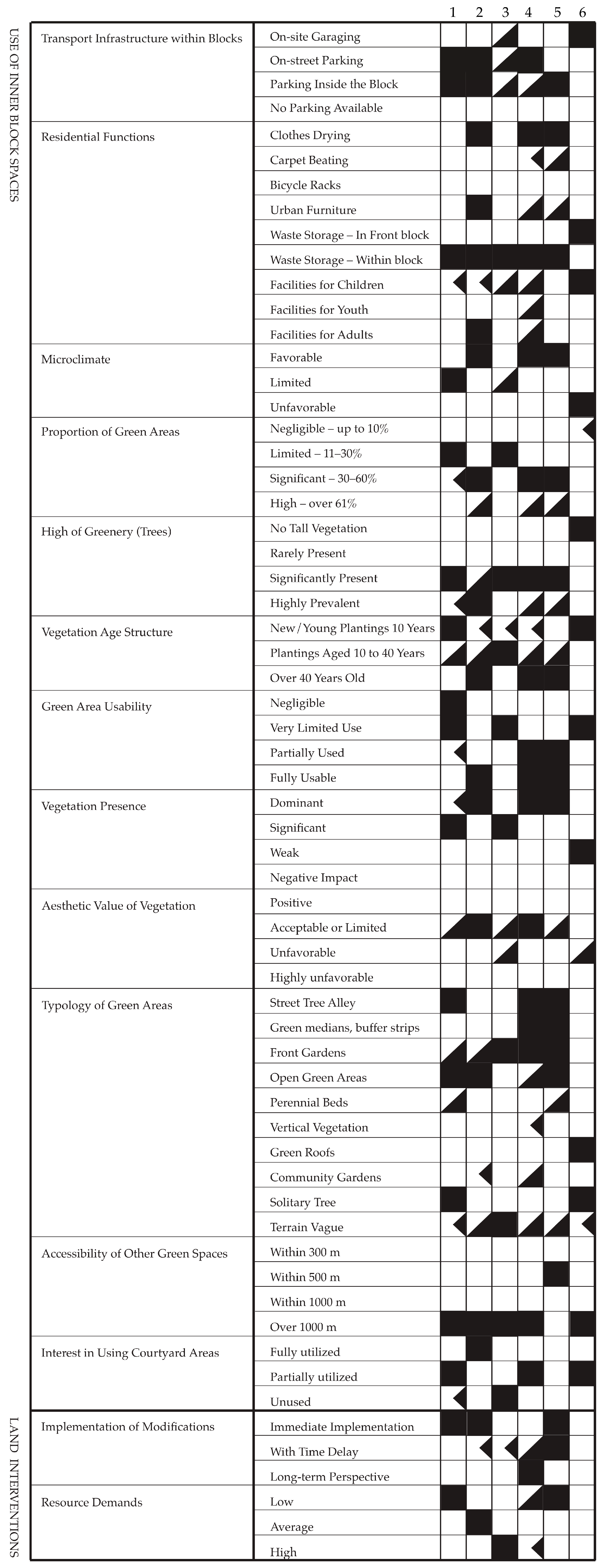
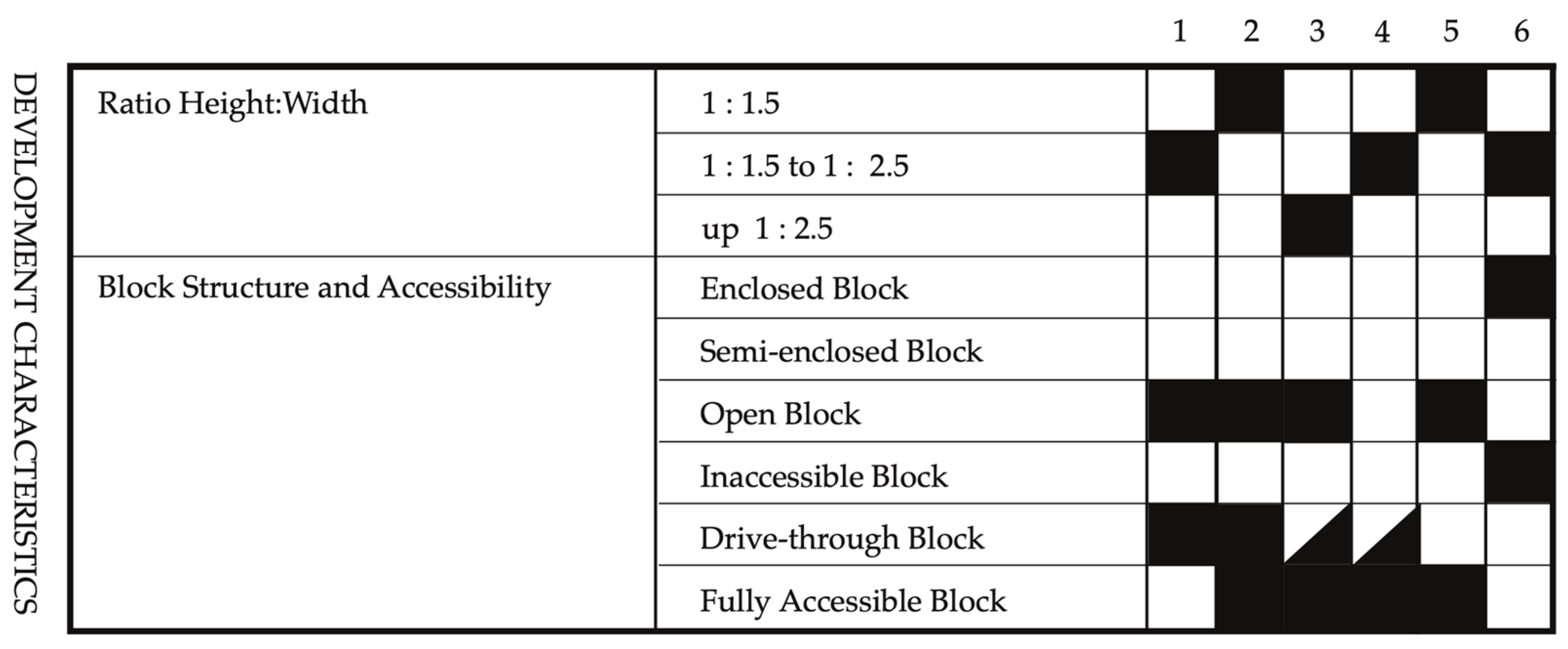
The assessment matrix (Appendix A) was designed to capture both measurable and experiential dimensions of housing estates. It brings together indicators that describe the physical structure of the built environment, the organization and quality of internal open spaces, and the potential for future landscape upgrading. By combining these dimensions, the framework provides a structured basis for comparing estates that differ in scale, typology, and period of construction. The criteria are organized into three thematic groups: basic spatial data, recorded in exact values such as floor numbers, footprint, or undeveloped areas; built environment characteristics and internal open space functionality, which cover accessibility, vegetation, microclimate, and community-related equipment; and potential for landscape upgrading, addressing feasibility and resource demands of future interventions. To ensure comparability, the majority of the indicators were assessed using a unified graphical scoring system (Figure 2), while numerical parameters were retained in precise metric form. This hybrid approach facilitates cross-case evaluation and highlights broader patterns while remaining sensitive to the particularities of each estate.
Although several of the indicators inevitably involve qualitative judgment––such as assessment of aesthetic value, usability of greenery, or social activation––these were not left to arbitrary interpretation. All evaluations were caried out using a predefined set of criteria, applied consistently across the six case studies, and supported by systematic field surveys and photographic documentation. In this way, subjectivity was structured and made transparent, transforming it into a replicable procedure rather than a limitation.
Each non-numerical indicator is assessed using a four-tiered graphic symbol system, based on the degree to which a given criterion is fulfilled within the context of a specific housing estate. The scores are visualized as filled geometric squares, which intuitively communicate the level of compliance or suitability with the desired spatial, ecological, or social qualities. The scoring logic is as follows:
  • ■ Full Square—(100%)—The criterion is fully met; the condition is appropriate, functional, or contextually satisfactory.
  • ◪ Half Square (50%)—The criterion is partially fulfilled; only some aspects of the condition are present or function effectively.
  • ◰ Quarter Square (25%)—The criterion is marginally fulfilled; the condition is present or insufficient
  • □ Empty Square (0%)—The criterion in not met at all; the condition is absent or entirely unsuitable [32].
This method does not produce numerical scores for statistical aggregation but serves as a diagnostic and comparative tool, making it possible to detect patterns, gaps, or recurring issues across multiple estates. It also allows for semi-quantitative interpretation of spatial qualities that are otherwise difficult to standardize, such as microclimatic comfort, vegetation character or functional use of inner blocks. This method will form the basis for further discussion in the results and interpretation sections, where individual and typological performance will be analyzed in greater depth.
Basic Spatial Data
The assessment begins with a set of core metrics (Table 1) that provide an objective baseline for comparing the physical characteristics of each estate. These quantitative parameters include the year of construction, which situates the estate within a specific historical and planning context; the overall land area in hectares (ha); the total built-up area in hectares (ha); and the extent of unbuilt land, expressed in hectares (ha). Such data are essential for understanding the proportion between constructed and open space and serve as a baseline for subsequent qualitative assessment. An important component within this category is also the number of floors, which reflects the vertical dimension of the built environment and directly influences urban form. Additionally, the typology captures the structural configuration of the housing estate. This is categorized into six distinct forms (a—point development, b—row development, c—ridge development, d—open structures, e—open courtyards, f—block development).
Built Environment Characteristics
Spatial qualities and physical configuration of the built environment were assessed within each housing estate. The analysis considers relationship between built form, accessibility and terrain as key determinants of spatial quality and user comfort. Four primary indicators were applied:
  • Hight-to-Width ratio of building blocks—This indicator evaluates the proportion between the height of the surrounding buildings and the width of the courtyard space. Blocks with a ratio up to 1:1.5 were considered less favorable, those between 1:1.5 and 1:2.5 acceptable, and blocks exceeding 1:2.5 highly favorable.
  • Vehicular accessibility of courtyard spaces—Fully enclosed blocks are accessible only to pedestrians, partially accessible blocks allow limited-service routes or passages, while fully open blocks permit direct vehicular access through open entries.
  • User accessibility and use of courtyard spaces—Courtyards may be privatized and used individually, semi-public when reserved for civic amenities, shared when accessible to multiple residents, or hybrid when combining private and shared functions.
  • Terrain conditions within courtyard spaces—Flat terrain provides uniform accessibility, mild slopes introduce slight elevation differences, moderately sloping terrain is more articulated, and strongly sloped areas are the most limiting but distinctive.
Internal Open Space Functionality
These spaces, located within residential blocks or between building forms, serve as transitional zones that mediate between private and public realms. Their quality, accessibility, usability, and spatial layout influence how well they support social interaction and contribute to the overall liability of the housing environment. The following key indicators have been identified to assess their physical characteristics and levels of usability:
  • Transport related functions—Garage access integrated directly into the block, street-side parking along adjacent roads, internal courtyard parking, or the complete absence of parking facilities.
  • Residential outdoor uses—Outdoor functions linked to everyday residential needs included laundry drying infrastructure, rug-beating frames, bicycle racks, public seating and other forms of urban furniture, and waste container placements, as well as play and rest facilities designed for children, youth, or adults.
  • Microclimatic conditions—Microclimate was assessed as favorable where adequate ventilation and at least partially open block configurations were present; as limited where dust, traffic pollution, lack of vegetation, or excessive paving caused deficiencies; and as unfavorable where spaces were poorly ventilated, inadequately sunlit, overly dense, or largely devoid of greenery.
  • Usability of green areas—Green spaces were considered negligible when serving only a decorative function, of very limited usability when constrained by slope; damage, or lack of infrastructure; and partially usable where they were used occasionally but not fully integrated into structured activities.
  • Vegetation coverage—Coverage was classified as dominant when vegetation defined spatial structure and character, significant when it occupying a substantial though not prevailing share, weak when only marginally present, and negative where vegetation was absent or insufficient, negatively impacting microclimate and aesthetics.
  • Aesthetic value of vegetation—Vegetation aesthetics ranged from positive, where it was well maintained, diverse, and visually coherent; through acceptable with limitations, where inconsistencies in design or care were evident; to unfavorable, where neglect or poor arrangement degraded the space; and highly unfavorable, where vegetation was absent or in very poor condition.
  • Vegetation typology—Vegetation types included street tree alleys, buffer belts and green medians, front gardens, open green areas, perennial beds, vertical vegetation, green roofs, community gardens, solitary trees, and spontaneous vegetation occupying residual or neglected land.
  • Accessibility of external green spaces—Accessibility was graded according to walking distances: excellent within 300 m (5 min), good up to 500 m (10 min), limited up to 1000 m (15 min), and poor beyond 1000 m, where external green spaces ceased to play a regular role in daily routines.
  • Interest in using courtyard areas—Use intensity ranged from fully utilized, with diverse groups actively present and facilities maintained, to partially utilized, where activity was occasional or limited to certain groups, and unused, where courtyards lacked visible social presence and often served only as transit or parking areas.
  • Implementation of modifications—Feasibility of improvements was assessed as immediate for low-cost or pre-approved measures, achievable with a time delay for medium-scale projects requiring coordination, or long-term for major interventions tied to reconstruction, planning revisions, or significant investment.
  • Resource demands—Finally, resource demands were categorized as low for minimal-cost or participatory interventions, average for measures requiring moderate construction or municipal investment, and high for projects demanding substantial planning, regulatory approval, and financing.

2.1.3. Weighted Synthesis Model

While the preceding subsections presented a detailed qualitative comparison of the six case studies, a simplified weighted sum model was additionally applied in order to synthesize the findings into a single comparative framework. Three key thematic dimensions were selected:
  • Vegetation and microclimatic conditions—reflecting the extent, quality, and ecological performance of greenery, and its influence on local climate regulation.
  • Social use and community engagement—capturing the degree of functional programming, availability of amenities, and resident appropriation of public spaces.
  • Spatial-functional configuration—evaluating the clarity, accessibility, and adaptability of spatial layouts.
Each dimension was assessed on a 0–4 scale (Table 2), where 0 indicates highly unsatisfactory conditions and 4 represents optimal performance. To reflects their relative importance, the categories were assigned weights of 0.4 for vegetation and microclimate, and 0.3 each for social use and spatial-functional configuration. The final weighted sum score (WS) for each housing estate was calculated as the linear combination of three dimensions, as mentioned before––vegetation and microclimatic quality (M), social use and community engagement (S), and spatial configuration (C)––according to their assigned wights (0.4, 0.3, and 0.3, respectively) as shown in Equation (1):
WS = (0.4 × M) + (0.3 × S) + (0.3 × C)
In assigning relative weights, vegetation and microclimatic performance were given greater importance compared to spatial configuration and social use. This emphasis reflects the recognition that green infrastructure and microclimate regulation represent critical determinants of long-term livability, environmental resilience, and climate adaptation in housing estates.

2.2. Study Areas

The comparative study focuses on six housing estates within the city of Nitra, Slovakia, which collectively illustrate the evolution of collective housing from the early post-war period to the present day. The urban structure of Nitra has been shaped by successive phases of residential development, each reflecting broader political or planning paradigms. As a mid-sized city in western Slovakia, Nitra experienced significant growth during the socialist period, particularly from the 1950s through the 1980s, when the state prioritized mass housing construction. The legacy is visible in the range of housing typologies, densities and spatial logics present across its residential areas. Following the transition to market economy in the 1990s, the city has continued to expand, with new housing developments increasingly influenced by privatization and contemporary urban design practices. The selected housing estates represent distinct stages in this trajectory, capturing both the continuity and transformation of urban form and the approach of green space within collective housing environments. Their comparative analysis enables a structured examination of how different planning approaches have addressed issues of spatial organization. The selected housing estates (Figure 3) include Čermáň (CS1), Staré Mesto (CS2), Stavbárska (CS3), Chrenová (CS4), Predmostie (CS5), and Tabáň (CS6).

2.2.1. Case Study 1—Point Development

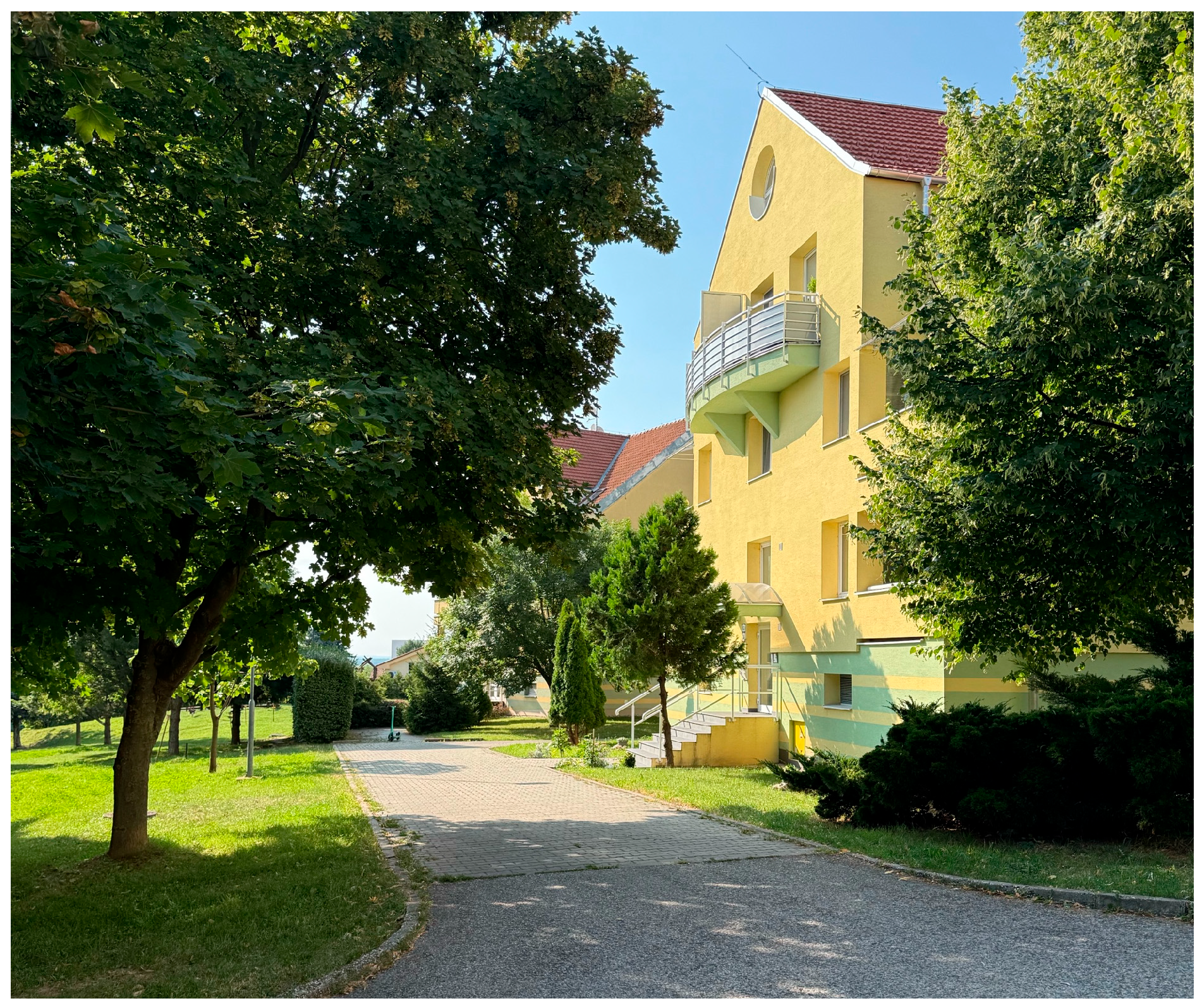
Developed between 1993 and 2007, this residential area exemplifies a late application of the point development morphology, characterized by freestanding multi-family housing units interspersed with generous green spaces. Situated on the urban periphery, Čermáň (Figure 4) reflects a period of decentralization in post-socialist urban growth. Its dispersed spatial configuration is the result of an architectural-urban design study selected through a national competition, highlighting a deliberate emphasis on landscape integration, recreational potential, and low-density living. The estates layout demonstrates an intentional departure from compact urban form, favoring permeability and visual openness in response to its peripheral location. While the estate benefits from a relatively generous share of green space, the lack of functional programming is evident. Courtyards host minimal amenities, with one playground and little additional social infrastructure. Green areas are largely residual, without clear zoning or recreational value, and community appropriation has remained weak. The absence of landscape architectural input in the project is also visible in the limited ecological and social performance of the estate’s open spaces.

2.2.2. Case Study 2—Row Development

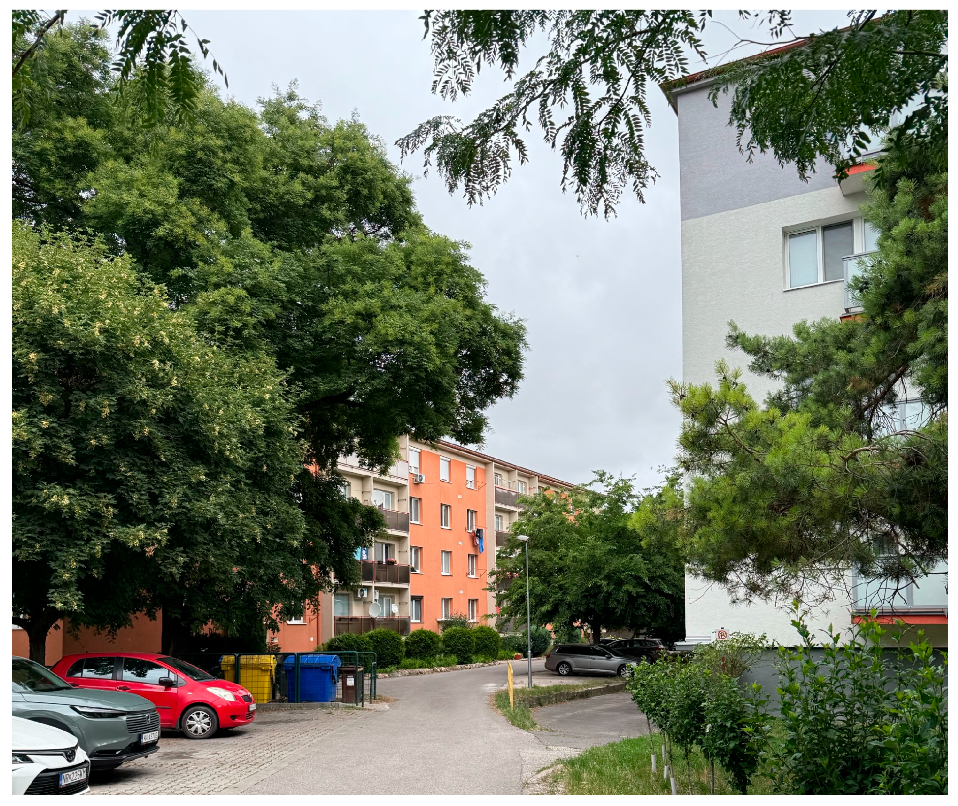
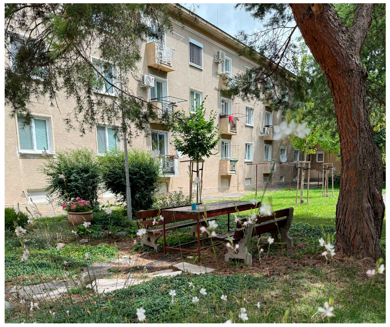
As the oldest segment within the selected sample, Staré Mesto (CS2) (Figure 5) represents a traditional typology—row development. The low-rise, two-floor development is arranged around an accessible and well-utilized inner courtyard, which plays a central role in shaping the quality of life for its residents. Despite its age, the estate exhibits strong microclimatic performance, thanks to a mature green structure and the presence of shading elements that moderate temperature extremes. Spatially, the area is exceptionally well-equipped: benches, playgrounds, and multifunctional surface provide amenities suitable for all age groups, reinforcing the estates inclusive design. What makes this case particularly notable is the visible presence of the communal spirit—residents have installed system for harvesting rainwater in shared containers, demonstrating environmental awareness and stewardship. The courtyard space is not only physically active but socially vibrant, reflecting the long-standing bonds of the local community.

2.2.3. Case Study 3—Ridge Development

Developed around 1960, this residential district represents (Figure 6) one of the oldest housing estates in Nitra and exemplifies the ridge development typology. Constructed mainly during the late socialist period, the estate was designed with buildings following the natural topographic lines, resulting in elongated spatial compositions and the formation of linear green corridors between rows of housing. From the microclimatic perspective, the estate performs relatively well: the combination of shading from mature vegetation, sufficient openness for air circulation, and the presence of green surfaces contributes to an overall favorable environment. However, the functional structure of the inner spaces is weakened by the high level of vehicular permeability. Courtyard areas remain largely traversed by cars, fragmenting the greenery, and reducing opportunities for social appropriation. Maintenance and aesthetic quality of the green spaces is uneven. While some newer plantings have appeared––likely initiated by residents––many areas lack systematic care, leading to a decline in visual coherence. Community-driven interventions are limited, and the absence of structured amenities reduces the potential of courtyards to act as active social nodes.

2.2.4. Case Study 4—Open Structures

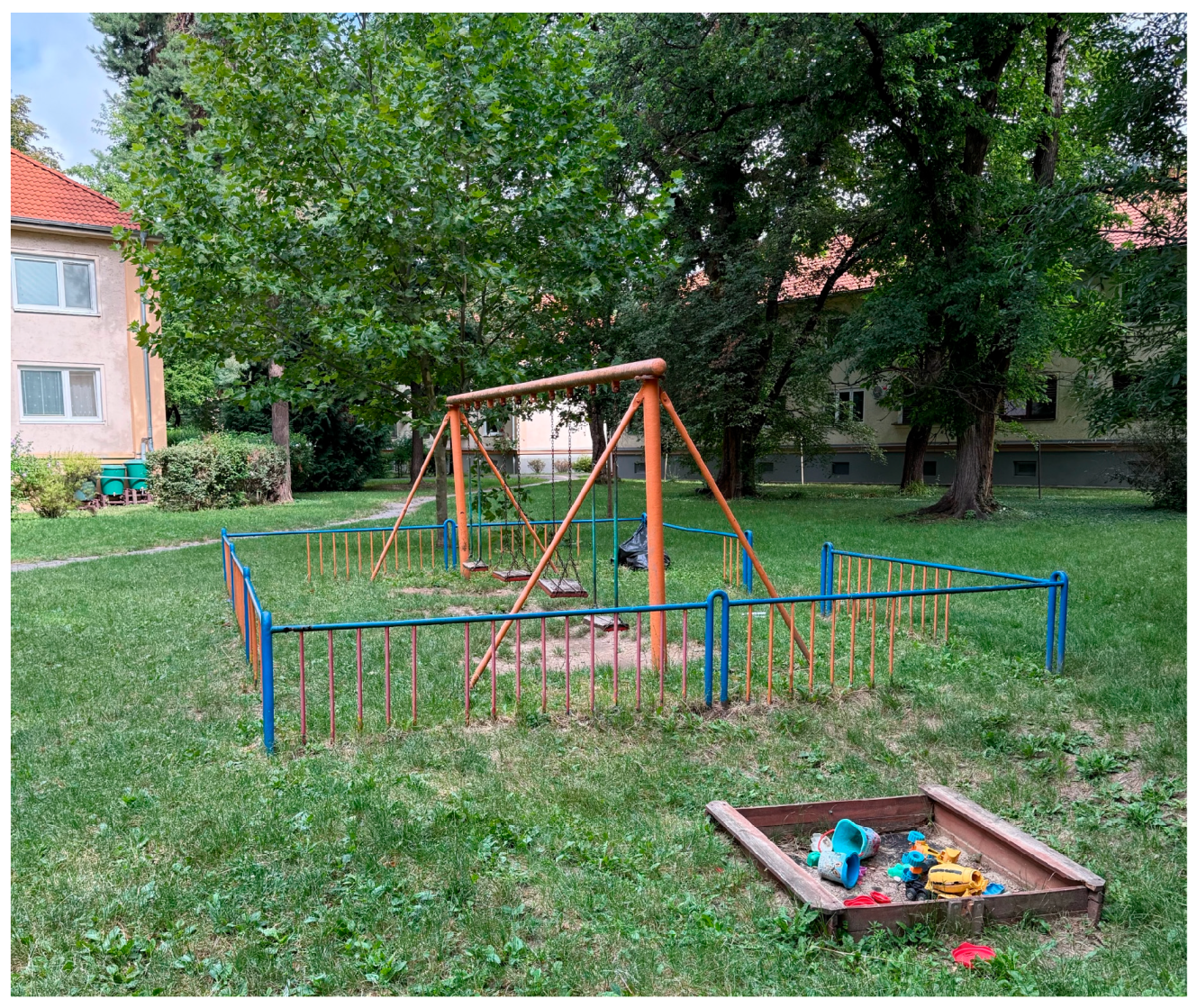
Chrenová (Figure 7) is one of the largest and most significant housing estate in Nitra, built primary during the 1970s and 1980s. Unlike other estates, its design was shaped by a more experimental approach to modernist planning, with dispersed residential blocks arranged in a non-axial, flexible layout that departed from rigid socialist-era models. This combination of architectural variety and extensive open land makes Chrenová a particularly important case study. The open spaces of Chrenová often retain original communal elements like playgrounds and seating, which, despite aging, still support community life and spatial quality. From a microclimatic perspective, the estate benefits from generous green buffers and sufficient ventilation, with shading provided by mature vegetation. However, the quality of green infrastructure is inconsistent: many lawns are residual and poorly maintained, while only limited areas have been adapted for active use. Community appropriation is visible in several places, with residents creating raised garden beds, informal seating, and small social corners, yet these efforts compensate only partially for the absence of structured programming and systematic landscape management. Chrenová therefore illustrates both the strengths and weaknesses of large-scale open structure estates, combining potential with persistent functional underuse.

2.2.5. Case Study 5—Open Courtyard

Predmostie (Figure 8) housing estate represents a characteristic example of the open courtyard typology, where residential buildings are arranged in a coherent configuration around a shared central courtyard. Constructed approximately between 1955 and 1965, the estate has retained its original spatial form and functional layout with minimal structural changes. This morphology creates a balance between permeability and enclosure, providing both openness and sense of privacy. The estate contains extensive green areas, which remain relatively well maintained and diversified. The central courtyard provides a semi-private outdoor environment designed primary for resident’s leisure and relaxation. Functional infrastructure is comparatively strong: benches, playgrounds for children and youth, and recreational facilities for adults are present, making the estate socially inclusive across age groups. Laundry drying frames and carpet-beating stands––remnant of the socialist era––are still in use. Community interest is visible in both maintenance and informal planting initiatives. Despite partial vehicular access, Predmostie exhibits a positive balance of ecological and social qualities, supporting active neighborhood life.

2.2.6. Case Study 6—Block Development

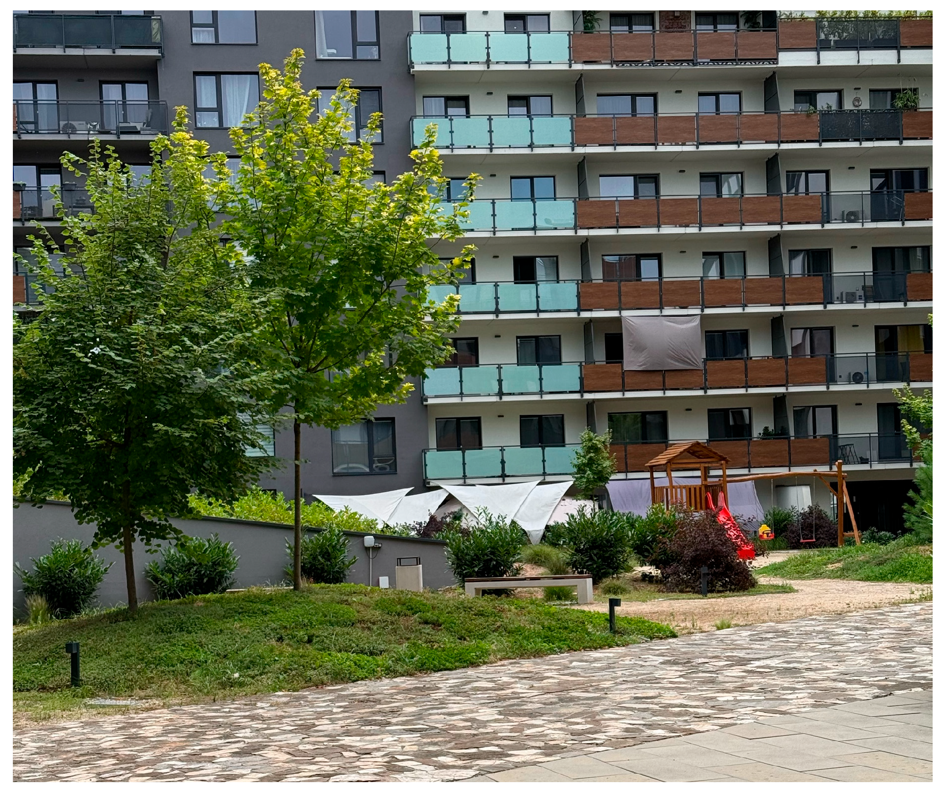
Tabáň (Figure 9) constructed between 2019 and 2021 on a brownfield site in the inner city, represents a classic example of block development, distinguished by its fully enclosed configuration and restricted internal access, limited to residents and service personnel. The complex integrates mixed-use functions; commercial units occupy the ground floor, while the upper stories are dedicated to housing. While the project originally included a landscape design prepared by a landscape architect, the final implementation was simplified by the developer to reduce costs. As a result, the courtyard contains extensive paved surfaces, sparse ornamental plantings, and insufficient tree cover or street furniture. Microclimatic conditions are unfavorable, with heat accumulation and insufficient shading. Despite its modern image, Tabáň demonstrates how cost-cutting and profit-oriented approaches lead to reduce ecological quality and restricted opportunities for community interaction. As one of the most substantial residential constructions in Nitra, Tabáň holds a significant position within the city’s urban framework.

3. Results

The comprehensive assessment of six selected housing estates in Nitra revealed significant differences in their spatial configuration, functional programming, quality of vegetation, and social use of inner courtyards. Although evaluated with the same set of indicators, the estates demonstrated distinct patterns in how they support or constrain everyday residential life. Key contrasts emerged in the diversity of amenities, the contribution of vegetation to local microclimate, and the extent of community engagement. Some estates displayed active resident appropriation and adaptation of spaces, while others lacked even basic infrastructure. Differences also reflected development modalities: socialist-era estates tended to provide larger vegetated areas but now suffer from under-maintenance, whereas post-2000 private projects prioritized density and market value at the expense of social and ecological quality.
For clarity, the findings are structured into key thematic dimensions encompassing the spatial and functional articulation of courtyard areas, the quality of vegetation and associated microclimatic performance, patterns of social use and community engagement, the alignment between original design intentions and the realized built form, and the emergence of terrain vague spaces reflecting deficiencies in the original masterplans.

3.1. Spatial and Functional Articulation of Courtyard Areas

Older estates such as Chrenová (CS4) and Predmostie (CS5) showed the highest functional saturation, including facilities such as drying racks, children’s playgrounds, and areas designated for adults, such as seating zones and community gathering spaces. Raised garden beds and informal community features were also identified in these areas. By contrast, Čermáň (CS1), developed between 1993–2007, contained a large courtyard, where over 81% of the area was green, but offered only a single playground and almost no communal infrastructure. Tabáň (CS6), built after 2000, provided a compact courtyard of which just 25% was vegetated, largely above an underground garage. The courtyard design was simplified during construction, resulting in minimal vegetation, one small playground and two benches. Staré Mesto (CS2) and Stavbárska (CS3) presented intermediate conditions, with green shares of roughly 75% and 65%, where functionality varied across blocks and often depended on resident adaptation.

3.2. Vegetation and Microclimatic Conditions

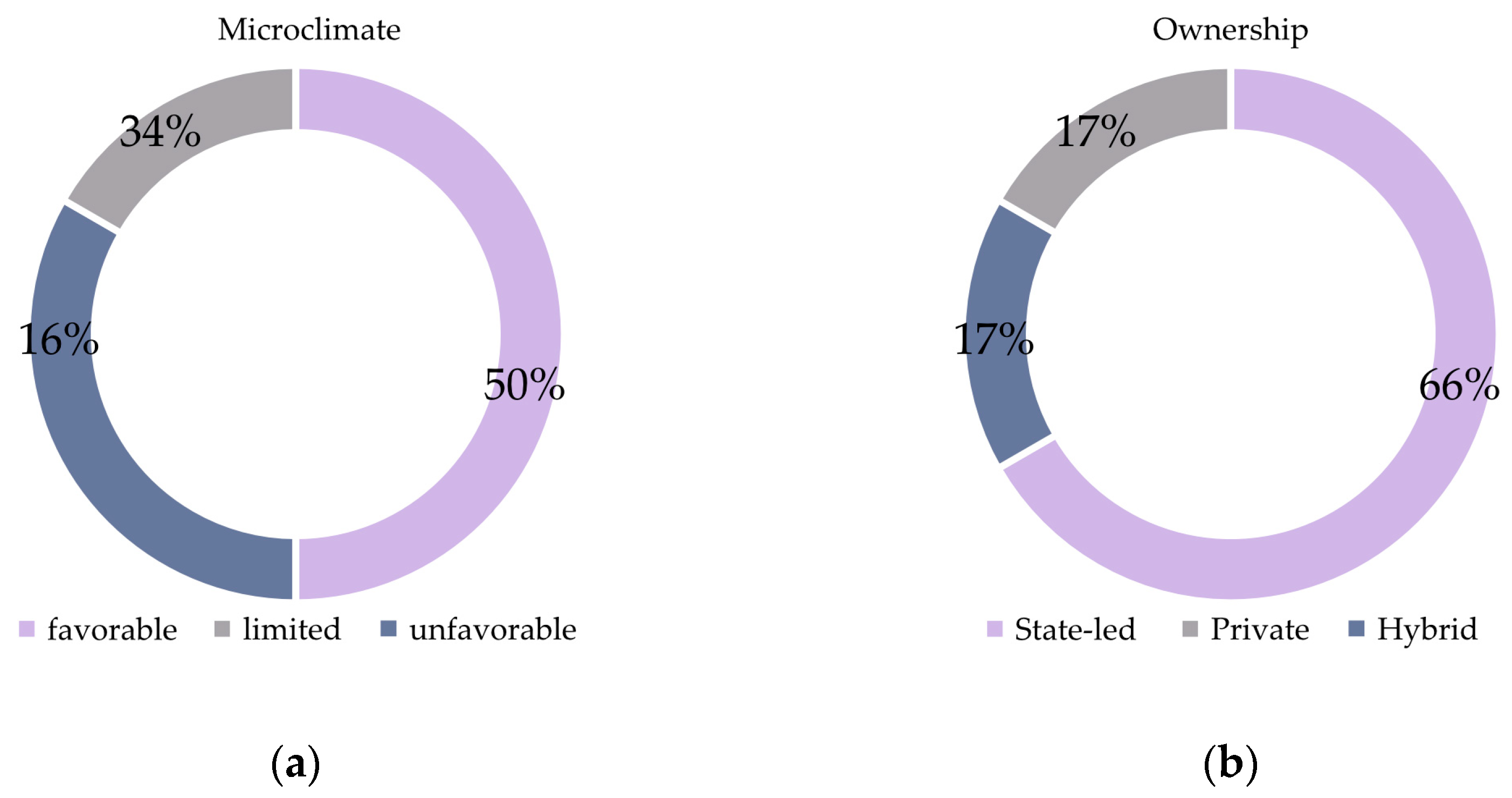
The quality of vegetation and its influence on microclimatic conditions (Figure 10) constitute a central determinant of the livability and ecological value of residential environments. Comparative analysis across six evaluated housing estates revealed pronounced differences in both the density and structure of vegetative elements, as well as in their capacity to moderate local microclimatic factors such as shading, ventilation, water retention, and mitigation of thermal extremes.
  • Čermáň (CS1): Out of total 5.9 ha, green areas account for 4.8 ha (81%). This represents the highest relative share of greenery among the case studies. However, the vegetative structure is largely uncoordinated, with limited species diversity, poor maintenance, and a lack of canopy trees. As a result, its potential for microclimatic improvement is only partly realized.
  • Staré Mesto (CS2): Of the 2.7 ha total, 2.1 ha are green areas (78%). Vegetation is mainly composed of mature rows of trees located in courtyards and streets. These provide consistent shading and contribute to favorable microclimatic conditions. While the species palette is not highly diverse, the overall structure is well established and offers one of the most stable and socially valued green environments among the analyzed estates.
  • Stavbárska (CS3): Green space represents 1.6 ha out of 2.4 ha (67%). Here, spontaneous vegetation combines with newer plantings, but microclimatic benefits are inconsistent.
  • Chrenová (CS4): With 5.6 ha of greenery out of total 7.2 ha (78%), this estate contains the largest absolute green area among all cases. Mature tree cover continues to moderate summer heat, through understory vegetation is declining.
  • Predmostie (CS5): Out of 2.8 ha, 1.9 ha are green areas (68%). The central courtyard vegetation remains effective in improving shading and thermal regulation, providing one of the more favorable microclimatic conditions.
  • Tabáň (CS6): The smallest share of greenery: 0.2 ha of 0.8 ha (25%). Vegetation is mostly ornamental, with limited shade or ecological function. Large, paved surfaces contribute to overheating, making this estate the least favorable micro climatically.
In summary, older housing developments such as Chrenová and Predmostie retain the largest absolute areas of greenery, which continue to provide important ecological functions, while Čermáň stands out for its very high proportional share. By contrast, Tabáň shows the sharpest deficiency, both in extent and quality of vegetation.

3.3. Social Use and Community Engagement

The social use of public spaces and the extent of resident participation are key indicators of housing estate quality, shaping perceptions of safety, accessibility, and community life. Across the six case studies, levels of activity and cohesion varied, largely influenced by spatial scale, clarity of zoning, and the presence of amenities.
Čermáň (CS1) shows limited engagement, although spacious, its courtyard lacks functional zones and furniture, making it transit space rather than community hub. Staré Mesto (CS2) fosters the most active community life, its enclosed atrium supports daily encounters, complemented by resident-led initiatives such as handmade benches and decorations. Tabáň (CS6), despite modern design, remains sterile; its gated layout and lack of shade or seating discourage social use. Stavbárska (CS3) display mixed conditions, with some active pockets but no unifying social element. Chrenová (CS4) offers potential through its open structure, yet activity remains fragmented and hindered by poor coordination and deteriorating infrastructure. Lastly Predmostie (CS5) benefits from stronger neighborly ties, and the overall social interaction is favorable.
Overall, the findings confirm that successful community life depends less on design form alone and more on scale, accessibility, maintenance, and resident involvement. Estates with intimate, shared spaces (CS2, CS4, CS5) demonstrate stronger social bonds, while larger or fragmented layouts without clear programming tend to suppress community interaction.

3.4. Implementation vs. Original Design Intent

The alignment between original design intentions and realized built environment varied sharply, particularly when comparing estate developed under state-led models with those delivered by private developers. In older estates like Predmostie (CS5) and Chrenová (CS4), the realized environment reflects a relatively high fidelity to the original planning ethos, whish prioritized collective life, open space access and functional diversity. Even when later resident-led modifications emerged, these typically complemented rather than disrupted the overall spatial coherence.
Developments such as Čermáň (CS1), and Tabáň (CS6) illustrate the challenges of maintaining design integrity in a commercial context. While Tabáň was initially designed with the involvement of a landscape architecture, the final implementation drastically diverged from the proposed plan. A simplified, low-cost version was executed, omitting essential elements such as shaded seating, tree planting, or meaningful green infrastructure. The result is a courtyard that lacks the environmental and social qualities envisioned in the design phase.
In Čermáň (CS1), there is a little evidence that a comprehensive landscape or community-use strategy was ever part of the development agenda. The space is characterized by minimal programming and insufficient attention to long-term maintenance or ecological performance. The absence of bicycle infrastructure across all newly built estates further highlights the disconnect between user needs and developer priorities.

3.5. Terrain Vague and Masterplan Deficiencies

The concept of terrain vague, as introduced by architect Ignasi de Solà-Morales [8], refers to urban spaces that lie outside active management and use––physically present but socially and programmatically vacant. In the housing estates studied, such spaces reveal systematic weaknesses and lack of long-term stewardship.
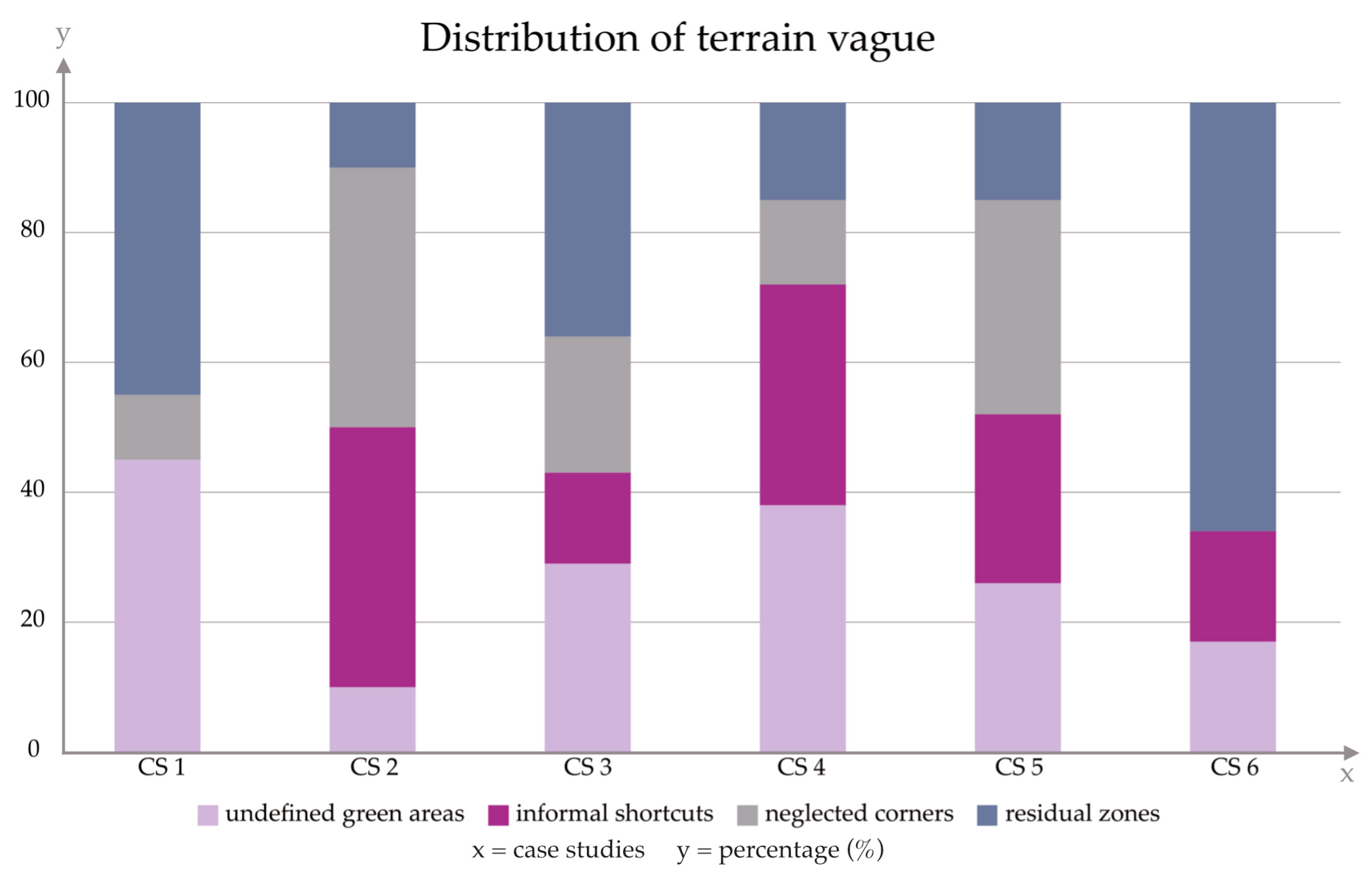
Across all case studies, recurring forms of terrain vague were observed (Figure 11):
  • Undefined grassy areas with no function (CS1, CS4, CS6)
  • Informal pedestrian shortcuts exposing a disconnect between planned and actual circulation (CS2, CS4, CS5)
  • Neglected rear facades and transition zones perceived as unsafe (CS2, CS5)
  • Residual spaces near parking or technical areas that have lost social or ecological value. These areas often remain unmaintained, reinforcing perceptions of abandonment and, in severe cases, contributing to insecurity or vandalism.
Such outcomes stem from deficiencies embedded in modernist master planning: overly generous scales without maintenance capacity, “neutral” spaces left undefined, dispersed amenities lacking focal points, blurred boundaries between public and private realms and little anticipation of future demographic or climatic change.
Field observation confirm these shortcomings. For instance, CS2 suffers from purposeless lawns; CS2 and CS3 contain fragmented backyards and inaccessible service areas; CS4’s vast open edges lack programming; CS5 shows signs of neglect; and even CS6, despite its recent construction, remains socially inactive, underscoring that formal design alone cannot guarantee place-making without user engagement.
Yet paradoxically, this terrain vague holds latent potential. If strategically reimagined, they could become ecological assets (biotopes, rain gardens, permeable surfaces) and social catalysts (community gardens, informal recreation, cultural initiatives). Addressing them is therefore not only a critique of past planning but a prospective challenge––transforming urban leftovers into active elements of microclimate regulation, social cohesion, and spatial justice.

3.6. Influence of Development Modality on Spatial Quality Outcomes

The development modality (Table 3), that is, the institutional and procedural framework guiding project design and delivery, exerts a decisive influence on the spatial quality of urban housing environments. Analysis of the six case studies reveals that ownership structure, investor type (public vs. private), planning approach (centralized vs. fragmented), and phasing strategy all critically shape the way space is used, experienced, and maintained. Three basic modality types were identified:
  • State-led collective development (CS2, CS3, CS4, CS5): Implemented between the 1960s and 1980s by public or cooperative developers following unified masterplans.
  • Post-transitional private developments (CS6): Initiated after 2000 by private developers, typically prioritizing saleable floor area. Public interest is often secondary; spaces may be of high formal quality but functionally exclusive.
  • Hybrid or uncoordinated development (CS1): Developed incrementally with overarching vision, combining remnants of original structures with later additions. The result is spatial fragmentation and incoherent interbuilding relations.
The outcome of cumulative, uncoordinated interventions, merging outdated structures with scattered insertions, is spatial incoherence and a loss of place identity. Private-led design may deliver formal sophistication but frequently neglects broader urban and social integration. A successful model must reconcile responsibility, openness, and long-term quality.

3.7. Spatial Adaptability and Long-Term Environmental Resilience

The capacity of housing estates to adapt to long-term challenges—climate change, densification, and demographic shifts—is central to their resilience. This emerges in two key dimensions: spatial flexibility and ecological performance.
Spatial flexibility reflects the ability of an urban structure to absorb changes in use or density without major reconstruction. It depends on reserves of public space, clear zoning between private and public areas, building typology, and the adaptability of existing infrastructure. The highest potential is seen in open, underdeveloped structures (CS1, CS3, CS4), where surplus land could host community gardens, retention areas, or new amenities. In contrast, compact private schemes such as CS6 remain rigid and resistant to change.
Ecological resilience is shaped by vegetation quality and biodiversity, the balance of permeable and sealed surfaces, water management systems, and material intensity. Modernist estates (CS2, CS4, CS5) still benefit from extensive green areas that support cooling, absorption, and ecological connectivity, though maintenance deficits persist. Recent developments (CS6), despite efficient buildings, are dominated by sealed surfaces and minimal vegetation, undermining their resilience.
Overall, long-term adaptability is strongest where spatial flexibility combines with robust green infrastructure. Yet these are not purely design qualities: their success depends equally on management, maintenance, and community engagement. Resilience, therefore, is as much a social and governance outcome as it is a physical one.

3.8. Results of the Weighted Sum Model

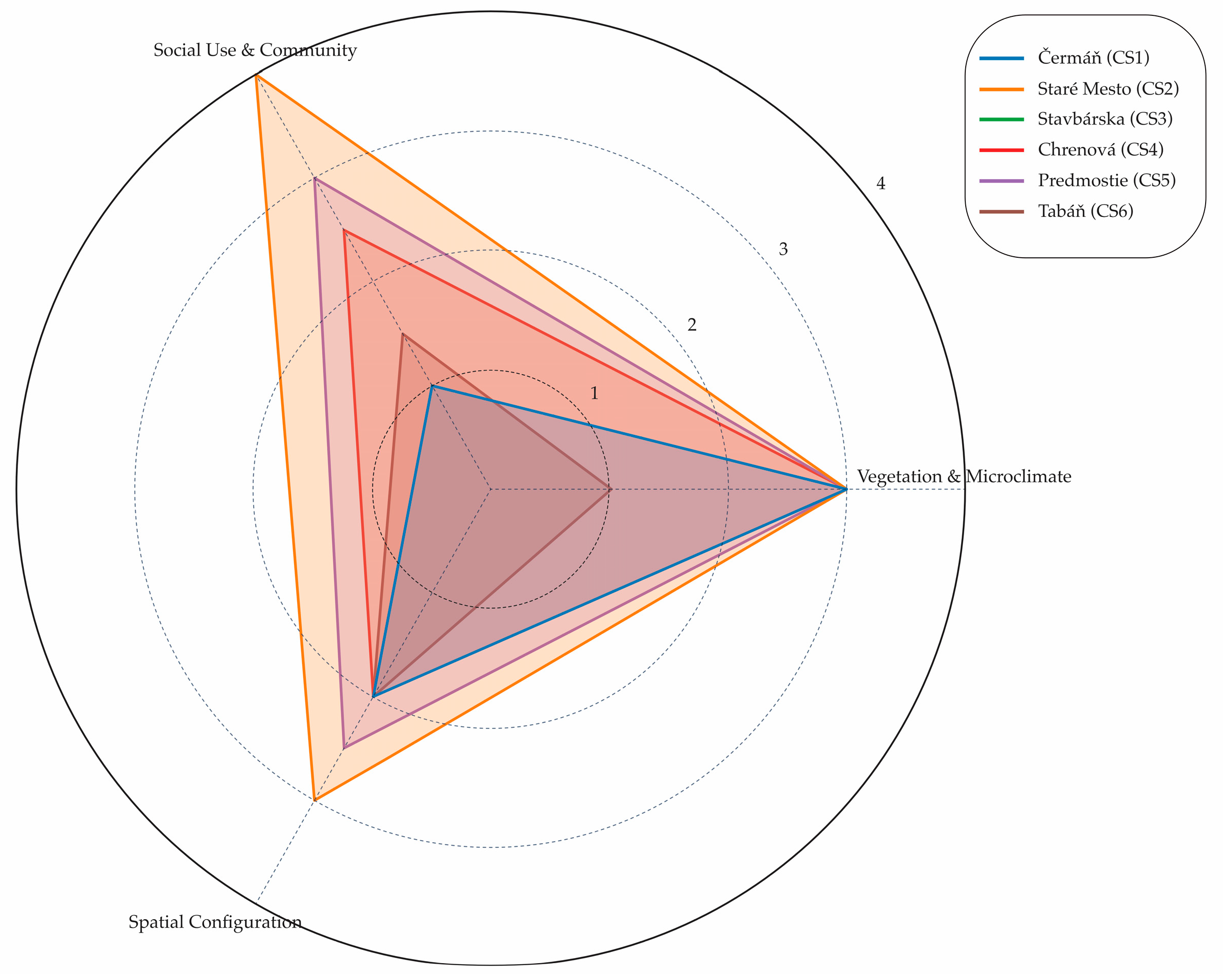
The results reveal clear differences across the case studies (Figure 12, in Section 3.9, Table 4). Staré Mesto (CS2) reached the highest score (3.3/4), benefiting from a relatively balanced combination of ecological quality, functional diversity, and active community appropriation. Predmostie (CS5) and Chrenová (CS4) followed (2.8 and 2.6, respectively), reflecting favorable vegetative structures and usable shared spaces, though with uneven maintenance. Stavbárska (CS3) and Čermáň (CS1) occupied a mid-range position (2.1 and 1.9), characterized by ecological potential but limited functional programming and social use. By contrast, Tabáň (CS6) ranked lowest particularly due to the lack of greenery, poor climatic performance, and minimal community infrastructure.
This pilot evaluation demonstrates the potential of combining qualitative field-based evaluation with simple numerical aggregation. Although inherently shaped by weighting choices, the model offers an accessible way to visualize the relative performance of different estates and to identify priority areas for intervention. It also illustrates a methodological pathway that could be further refined in future studies by applying more advanced multicriteria decision-making tools.

3.9. Graphical Interpretation of Key Findings

This section presents a visual synthesis of selected key findings derived from the comparative assessment. The following graphs and diagrams provide a more accessible overview of how six case studies performed across the evaluated dimensions, complementing the detailed numerical and descriptive results. In addition, a radar chart has been included to illustrate the weighted sum model across the three main dimensions––spatial configuration, social use, and vegetation with microclimatic quality. This graphical format highlights the relative strengths and weaknesses of each estate within a single comparative frame. For instance, the strong ecological and spatial scores of Chrenová (CS4) are clearly contrasted with the low values of Tabáň (CS6), while Predmostie (CS5) and Staré Mesto (CS2) demonstrate a more balanced and community-oriented profile.

4. Discussion

This study set out to critically examine the spatial, ecological, and social quality of collective housing estates in Nitra by applying a multicriteria framework––supported by a weighted sum model––to evaluate six housing estates in Nitra, focusing on the interplay between spatial organization, vegetation and microclimatic performance, and social use. The results demonstrated clear differences in how estates performed across these categories, underscoring the fact that residential quality is not determined by single attributes (such as density or greening) but by the balance of ecological, spatial, and social dimensions. Importantly, by assigning greater weight to vegetation and microclimatic conditions (0.4), the assessment reflects the recognition that ecological performance is fundamental to the livability, resilience, and long-term value of collective housing environments. They support sustainable development, linking the built and natural environments [34].
Vegetation proved to be the strongest differentiating factor between estates. Older housing complexes such as Chrenová (CS4) and Predmostie (CS5) scored highest in this category, with 78% and 68% green cover, respectively, largely due to their mature tree canopies and generous spatial layouts. These elements provide shade, mitigate overheating, and offer environmental buffering, resulting in weighted sub scores above 3.0. In contrast, newer developments such as Tabáň (CS6), with only 25% green cover, and Čermáň (CS1), where vegetation is expansive but poorly structured, performed significantly worse (scores around 1.0–1.5). The results highlight a paradox: while contemporary projects emphasize formal design, they often underestimate the ecological and microclimatic role of green infrastructure. Studies consistently demonstrate that structured vegetation reduces ambient temperatures, lowers Physiological Equivalent Temperature, and improves well-being [35,36]. Neglecting this dimension thus directly reduces environmental resilience and resident comfort.
The second dimension revealed an equally sharp contrast. Predmostie (CS5) and Staré Mesto (CS2) emerged as socially vibrant estates, with weighted sub scores around 3.2–3.4, largely due to their appropriation by residents (e.g., informal seating, raised beds, and, in CS2, resident-led rainwater harvesting). Again, in contrast, Čermáň (CS1), despite offering the largest share of green space (81%), was almost exclusively underused due to lack of furniture, zoning, or facilities, resulting in a low social score (1.2). This finding demonstrates that quantity of space is not equivalent to quality of use. As research shows, active community engagement is closely tied to perceptions of safety, inclusion, and ecological stewardship [37,38]. The observed everyday practices––whether rainwater collection or informal furnishing of courtyards––point to the significance of bottom-up, incremental interventions that supplement formal design with lived meaning.
Spatial form also proved decisive in shaping outcomes. Semi-open estates such as Chrenová (CS4), with its open structure, and Staré Mesto (CS2), with semi-closed courtyards, showed higher adaptability and user integration. Their layouts allowed for permeability, cross-ventilation, and multi-generational use. Conversely, Tabáň (CS6), with its enclosed courtyard atop a parking garage, demonstrated rigidity and lack of flexibility, earning the lowest sub score in this category (~1.3). These findings resonate with urban morphology research showing that block proportion, height-to-width ratios, and sky view factors significantly affect both thermal comfort and opportunities for adaptive reuse [39,40,41]. Adaptability is not merely a design question but also a governance one: without institutional support, even spatially flexible estates may remain underutilized.
Across all estates, some form of terrain vague was observed––whether in the form of oversized lawns, undefined backyards, or residual corners near parking areas. These areas reveal the limits of the botched socialist masterplan (with over-dimensioned and under-programmed public space) and contemporary private developments (where open space is minimized or sterilized). While such terrain often represents neglect, it also contains latent potential for ecological upgrading (e.g., gardens, informal play). Similar observations have been made in post-socialist housing research, where residual space is increasingly reframed as opportunities for small-scale ecological and social innovation [42].
The weighted sum analysis clarifies that ecological performance (vegetation and microclimatic) outweighs spatial or social design when it comes to long-term livability, though the latter dimensions remain indispensable for activating public space. Over the past 50 years, little has changed structurally: the socialist legacy of over-dimensioned but under-managed green space has been replaced by privatized developments that minimize or cheapen green infrastructure. In the case of CS6, for example, the original design prepared by a professional architecture was not followed through in execution; instead, the developer opted for a cheaper and quicker solution. This not only compromised the environmental and social potential of the space but also overlooked a crucial economic insight: well-designed and properly implemented GI can significantly increase the value of residential properties [43,44]. Developers often pursue cost-effective solutions that reduce landscape investment, yet this short-term logic ignores long-term ecological, social, and financial benefits [45].
At the same time, this study underscores the transformative potential of resident-led initiatives. These have significantly influenced urban development by fostering environmental efforts and social sustainability outside standard market mechanisms [46]. This aligns with research which stresses that community participation in the management of urban green spaces improves access, reduces environmental inequity, and enhances maintenance outcomes [47]. Likewise, studies on courtyard sociality argue that courtyards function as unique human habitats that integrate physical structure with social identity, facilitating intergenerational interaction, biographical connection, and sustained participation in place [48]. Successful estates such as Predmostie (CS5) illustrate how even modest courtyards can become vibrant communal spaces wen residents feel ownership and agency. Conversely, projects like Tabáň (CS6) highlight the shortcomings of relying solely on formal aesthetics without ecological or social depth.
Our findings confirm that even carefully structured evaluations of housing estates cannot fully escape subjective judgement. However, this limitation is also one of the strengths of qualitative assessment, as it allows us to capture ecological perceptions, aesthetic qualities, and social dynamics that purely numerical indicators would overlook. Recent studies emphasize that mixed-method approaches provide a more comprehensive picture of urban green infrastructure performance [49]. Within this perspective, our results align with broader methodological trends in urban and landscape research, where qualitative and experiential aspects are recognized as indispensable to understanding neighborhood livability.

5. Conclusions

Thus study has demonstrated that the quality of collective housing estates in Nitra is defined not by individual parameters but by the interplay of ecological performance, spatial configuration, and social activation. The weighted sum model highlighted that vegetation and microclimatic conditions carry decisive importance: estates such as Chrenová (CS4) and Predmostie (CS5), with 78% and 68% green coverage, respectively, consistently outperformed newer developments, reaching weighted scores above 3.0. In contrast, Tabáň (CS6), with only 25% green cover, and Čermáň (CS1), despite its 81% unstructured greenery, scored much lower (1.2). These results illustrate that quantity of space alone does not ensure livability; design quality, vegetation structure, and community appropriation are equally critical.
Overall, older state-led estates, despite maintenance deficits, still provide more resilient and socially meaningful environments than many newer private developments, where cost-cutting often undermines ecological and community value. This confirms that long-term livability depends on integrating green infrastructure with spatial adaptability and everyday community use. In terms of practical implications, municipalities and planners should prioritize structured vegetation and tree canopies as core infrastructure, introduce participatory mechanisms that empower residents to co-manage courtyards, and adopt design standards that balance ecological performance with mobility needs. For developers, these findings demonstrate that investing in high-quality green infrastructure and microclimatic design is not only environmentally beneficial but also economically advantageous, enhancing property value and long-term market appeal.
By systematically comparing estates across typological categories and historical phases, this research contributes to a deeper understanding of how socialist legacies and contemporary market-driven developments shape the quality of housing environments in Central and Eastern Europe. Although the analysis is anchored in Nitra, the findings hold broader relevance for other mid-sized European cities facing similar challenges of ageing housing stock, fragmented governance, and speculative development practices.
The results also open a dialogue between urban morphology, landscape architecture and housing policy, underlining the need for integrated strategies that transcend disciplinary boundaries. In doing so, this study contributes to the growing body of research on post-socialist housing estates by demonstrating the analytical value of integrating an ecological framework. This multidimensional approach offers a more nuanced perspective on long-term livability and resilience and can serve as a reference for comparative studies in other Central and Eastern European contexts.
Importantly, this study underscores that housing estates should not be viewed solely as inherited problems but as critical urban laboratories where ecological resilience, social cohesion, and long-term sustainability can be redefined. Ultimately, the future of housing estates depends on recognizing green infrastructure and community life as indispensable foundations of urban resilience. This recognition requires not only design innovation but also a long-term governance capacity and the active participation of residents, without which even technically sound projects may fail to deliver livable environments.
Future research will extend this approach by incorporating more qualitative environmental performance data and applying decision-making tools such as the Analytic Hierarchy Process (AHP) and Technique for Order of Preference by Similarity to Ideal Solution (TOPSIS) to validate the results. Expanding the number of case studies across Slovakia and including international best practices, as well as examining the legislative framework, will provide a stronger empirical and policy-relevant foundation for improving housing environments.

Author Contributions

Conceptualization, Z.V. and T.Ž.; Data curation, Z.V., T.Ž. and A.T.; Formal analysis, Z.V. and T.Ž.; Funding acquisition, A.T.; Investigation, Z.V. and T.Ž.; Methodology, Z.V. and T.Ž.; Project administration, A.T. and R.Š.; Resources, A.T.; Software, Z.V. and T.Ž.; Supervision, A.T. and R.Š.; Validation, Z.V., T.Ž., A.T. and R.Š.; Visualization, Z.V. and T.Ž.; Writing—original draft, Z.V. and T.Ž.; Writing—review & editing, Z.V., T.Ž. and A.T. All authors have read and agreed to the published version of the manuscript.

Funding

This paper is an outcome of the following projects: KEGA 004SPU-4/2023 KR:EK:IN—Landscape Economy for Innovative and Sustainable Interdisciplinary University Education in Slovakia; KEGA 038SPU-4/2024 M:INT—White Spaces and Ephemeral Urban Interventions; and VEGA 1/0535/24 STRO:ViD—Cultural Ecosystem Services of Trees in Public Open Spaces of the Slovak Countryside funded by the Ministry of Education, Research, Development and Youth of the Slovak Republic.

Conflicts of Interest

The authors declare no conflicts of interest.

Abbreviations

The following abbreviations are used in this manuscript:
CSCase study
GIGreen infrastructure

Appendix A. Full Comparative Assessment Table
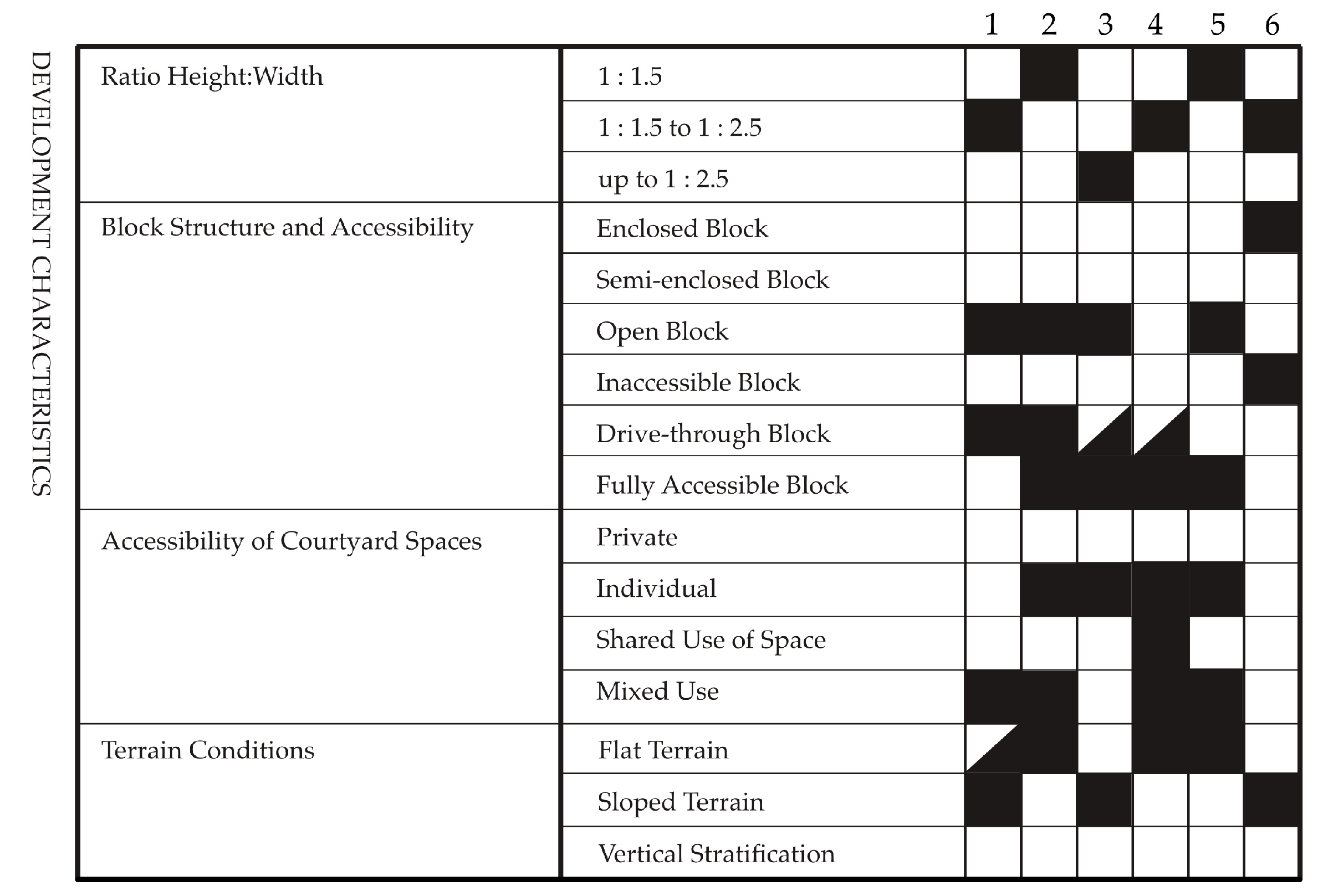
This appendix presents the complete comparative evaluation matrix applied to the six selected housing estates analyzed in this study. The table includes all key indicators and sub-indicators developed within the methodological framework outlined in Section 2.1.2. The assessment covers a broad range of spatial, environmental, social, and governance-related criteria, enabling a complex and layered reading of the qualities and deficiencies found in each case study. Each housing estate was assessed using a consistent set of indicators, including spatial legibility, presence of vegetation, microclimatic comfort, level of functional equipment, signs of active community use, and forms of long-term stewardship. The scores reflect both quantitative presence and qualitative performance, with attention given to factors such as maintenance, accessibility, and capacity for fostering social interaction.
The decision to place the full table in the Appendix was made due to its length and detailed content, which may be overwhelming in the main text but remains essential for transparency, reproducibility, and in-depth understanding of the evaluation process. In the main body of the paper, only selected aspects or individual indicators are visualized to illustrate the principle of the assessment and key findings. The complete table here (Figure A1 and Figure A2) provides the full structure and scores for all criteria used in the research and supports further comparison or methodological reflections.
Figure A1. This figure illustrates the introductory part of the evaluation table of the basic characteristics of the selected case studies.
Urbansci 09 00383 g0a1
Figure A2. The continuation of the evaluation table with regard to microclimate and vegetation occurrence.
Urbansci 09 00383 g0a2

References

  1. Haladová, I.; Petrovič, F. Predicted development of the city of Nitra in Southwestern Slovakian based on landcover-land use changes and socio-economic conditions. Appl. Ecol. Environ. Res. 2017, 15, 987–1008. [Google Scholar] [CrossRef]
  2. Sendi, R.; Kerbler, B. The evolution of multifamily housing: Post-Second World War large housing estates versus post-socialist multifamily housing types in Slovenia. Sustainability 2021, 13, 10363. [Google Scholar] [CrossRef]
  3. Haluzík, R. Město Naruby: Vágní Terén, Vnitřní Periferie a Místa Mezi Místy; Academia: Prague, Czech Republic, 2020; 400p. [Google Scholar]
  4. Buchli, V. An Archaeology of Socialism; Berg Publishers: Oxford, UK; New York, NY, USA, 1999; 240p. [Google Scholar]
  5. Barviková, J. Jak se žije na Jižním Městě z pohledu Husákových dětí. Soc. Stud. 2010, 3, 62. [Google Scholar] [CrossRef]
  6. Skřivánková, L.; Švácha, R.; Novotná, E.; Koukalová, M. Paneláci 2: Historie sídlišť v českých zemích 1945–1989. In Kritický Katalog k Výstavě Bydliště: Panelové Sídliště; Uměleckoprůmyslové Muzeum: Prague, Czech Republic, 2017. [Google Scholar]
  7. Maier, K. Sídliště: Problém a multikriteriální analýza jako součást přípravy k jeho řešení. Sociol. Čas./Czech Sociol. Rev. 2003, 39, 653–666. [Google Scholar] [CrossRef]
  8. Solà-Morales i de, I. Terrain Vague. Quad. D’arquitectura I Urban. 1995, 212, 34–43. [Google Scholar]
  9. Eichhorn, S.; Pehlke, D. Unintended effects of regional planning in Germany. Growth Change 2022, 53, 933–950. [Google Scholar] [CrossRef]
  10. Pavolová, H.; Bakalár, T.; Tokarčík, A.; Kozáková, Ľ.; Pastyrčák, T. Monitoring of Dust Pollution and Identification of Its Sources in an Urban Environment of Eastern Slovakia. Int. J. Environ. Res. Public Health 2021, 18, 3472. [Google Scholar] [CrossRef]
  11. Vitková, L. Premeny slovenských sídlisk—Súčasné problémy a perspektívy tvorby verejných priestorov. Urban. Čas. 2015, 2, 67–73. [Google Scholar]
  12. Polák, M. Historical Development of Social Housing. In Update of Slovak Housing Sector Profiles; Slovak University of Technology in Bratislava: Bratislava, Slovakia, 2004; pp. 62–63. [Google Scholar]
  13. Kabisch, N.; Haase, D. Green spaces of European cities revisited for 1990–2006. Landsc. Urban Plan. 2013, 110, 113–122. [Google Scholar] [CrossRef]
  14. Belčáková, I.; Slámová, M.; Demovičová, Z. Importance of Urban Green Areas in the Context of Current and Future Global Changes: Lessons Learned from a Case Study in Bratislava (Slovakia). Sustainability 2022, 14, 14740. [Google Scholar] [CrossRef]
  15. Chaves, C.; Tostões, A. Urban Planning and Housing in Lisbon from the 1950s: Some Hidden Facts. Buildings 2025, 15, 1115. [Google Scholar] [CrossRef]
  16. Starczewski, T.; Rogatka, K.; Noszczyk, T.; Kukulska-Kozieł, A.; Cegielska, K. Green spaces in Polish large, prefabricated housing estates developed in the socialist era. J. Hous. Built Environ. 2024, 39, 1987–2007. [Google Scholar] [CrossRef]
  17. Hess, D.B.; Kocaj, A.; Gorczyca, K. Envisioning a transformation of socialist-era housing estates into sustainability-infused eco-villages. Town Plan. Rev. 2024, 96, 1–16. [Google Scholar] [CrossRef]
  18. Solarek, K.; Domaradzka, A.; Zdunek-Wielgołaska, J. Changing approaches to green infrastructure design: From modernism to the future: Warsaw case study. Urban Des. Int. 2023, 28, 202–219. [Google Scholar] [CrossRef]
  19. Oosterbroek, B.; de Kraker, J.; Huynen, M.M.T.E.; Martens, P. Integrated assessment of health benefits and burdens of urban greenspace designs. Sustainability 2024, 16, 7534. [Google Scholar] [CrossRef]
  20. Kupka, J. Zeleň v Historii Města; Nakladatelství ČVUT: Prague, Czech Republic, 2006; 146p, ISBN 80-01-03443-7. [Google Scholar]
  21. Kristianová, K. Post-socialist transformations of green open spaces in large scale socialist housing estates in Slovakia. Procedia Eng. 2016, 161, 1863–1867. [Google Scholar] [CrossRef]
  22. Vinczeová, Z.; Tóth, A. Urban green spaces and collective housing: Spatial patterns and ecosystem services for sustainable residential development. Sustainability 2025, 17, 2538. [Google Scholar] [CrossRef]
  23. Izakovičová, Z.; Petrovič, F.; Pauditšová, E. The impacts of urbanisation on landscape and environment: The case of Slovakia. Sustainability 2022, 14, 60. [Google Scholar] [CrossRef]
  24. Nakip, G.G.; Żmudzińska-Nowak, M.; Balli, G. The neglected modern architectural heritage: Analysis of housing estates in the second half of the 20th century from Izmir, Turkey, case study area. Buildings 2024, 14, 3337. [Google Scholar] [CrossRef]
  25. Golubchikov, O. The urbanization of transition: Ideology and the urban experience. Eurasian Geogr. Econ. 2016, 57, 607–623. [Google Scholar] [CrossRef]
  26. Conzen, M.R.G. Alnwick, Northumberland: A Study in Town-Plan Analysis. Trans. Pap. 1970. iii–xi, 1–122. [Google Scholar] [CrossRef]
  27. Moudon, A.V. Urban Morphology as an emerging interdisciplinary field. Urban Morphol. 1997, 1, 3–10. [Google Scholar] [CrossRef]
  28. Wang, L.; Zhao, J.; Xiong, Z.; Zhuang, J.; Wang, M. Integrating Grey–Green Infrastructure in Urban Stormwater Management: A Multi–Objective Optimization Framework for Enhanced Resilience and Cost Efficiency. Appl. Sci. 2025, 15, 3852. [Google Scholar] [CrossRef]
  29. Liu, M.; Lai, C.; Zhang, Y.; Chen, B.; Wang, M. Multi-objective optimalisation of integrated grey-green infrastructure in response to climate change from a life cycle perspective. J. Clean. Prod. 2025, 498, 145162. [Google Scholar] [CrossRef]
  30. Figueira, J.; Greco, S.; Ehrgott, M. Multiple Criteria Decision Analysis: State of the Art Surveys; Springer: New York, NY, USA, 2016. [Google Scholar]
  31. Triantaphyllou, E. Multi-Criteria Decision Making: A Comparative Study; Springer: New York, NY, USA, 2000. [Google Scholar]
  32. Šubr, J.; Stencel, J. Zeleň Obytných Vnitrobloků; O. P. Sempre Praha—Výzkumný a Šlechtitelský Ústav Okrasného Zahradnictví v Průhonicích: Průhonice, Czech Republic, 1988. [Google Scholar]
  33. CIDEP. Forms of Settlement Structures, 1st ed.; Stadtenwicklung: Vienna, Austria, 2011; pp. 1–167. [Google Scholar]
  34. Tóth, A. Planning and designing green infrastructure across landscapes and scales. Acta Hortic. Regiotect. 2022, 25, 1–7. [Google Scholar] [CrossRef]
  35. Pérez-Arévalo, R.; Jiménez-Caldera, J.E.; Serrano-Montes, J.L.; Rodrigo-Comino, J.; Ortiz Royero, J.C.; Caballero-Calvo, A. Impacts of urban morphology on micrometeorological parameters and cyclonic phenomena in Northern Colombian Caribbean. Climate 2025, 13, 87. [Google Scholar] [CrossRef]
  36. Bian, C.; Lee, C.C.; Chen, X.; Li, C.Y.; Hu, P. Quantifying the thermal and energy impacts of urban morphology using multi-source data: A multi-scale study in coastal high-density contexts. Buildings 2025, 15, 2266. [Google Scholar] [CrossRef]
  37. Lindgren, T.; Castell, P. Open space management in residential areas—How it is organised and why. Int. J. Strateg. Prop. Manag. 2010, 12, 141–160. [Google Scholar] [CrossRef]
  38. Kabisch, N.; Korn, H.; Stadler, J.; Bonn, A. Nature-Based Solutions to Climate Change Adaptation in Urban Areas: Linkages Between Science, Policy and Practice; Springer: Cham, Switzerland, 2017. [Google Scholar]
  39. Dinić Branković, M.; Igić, M.; Đekić, J.; Ljubenović, M. Impact of urban densification on outdoor microclimate and design of sustainable public open space in residential neighborhoods: A study of Niš, Serbia. Sustainability 2025, 17, 1573. [Google Scholar] [CrossRef]
  40. Yu, H.; Piao, Y. The cooling effect and its stability in urban green space in the context of global warming: A case study of Changchun, China. Sustainability 2025, 17, 2590. [Google Scholar] [CrossRef]
  41. Lu, F.; Gao, Y.; Jiang, L.; Chen, Y.; Hao, Z. The effect of greening layout on microclimate in urban residential areas in hot summer–cold winter zones. Atmosphere 2023, 14, 1824. [Google Scholar] [CrossRef]
  42. Galmarini, B.; Chiesi, L. Repoliticizing Green Spaces in Urban Transitions. The Relevance of Governance for Equitable Ecological Planning. Putt. Political Its Place Towards A Political Sociol. Sustain. 2024, 15, 13–25. [Google Scholar] [CrossRef]
  43. Kim, J.H.; Li, W.; Newman, G.; Kil, S.H.; Park, S.Y. The influence of urban landscape spatial patterns on single family housing prices. Environ. Plan. B Urban Anal. City Sci. 2016, 45, 26–43. [Google Scholar] [CrossRef]
  44. Shukri, F.A.B.; Misni, A.B.T. The impact of roof gardens at high-rise residential buildings on property values. WIT Trans. Ecol. Environ. 2017, 226, 39–48. [Google Scholar]
  45. Bihuňová, M.; Štěpánková, R. Housing estate—Opportunities and threats for recreational activities. In Public Recreation and Landscape Protection—With Environment Hand in Hand! Mendelova Univerzita: Brno, Czech Republic, 2025; pp. 134–137. ISBN 978-80-7701-026-9. [Google Scholar]
  46. Pagh, C.; Coock, T. (Eds.) Mission Neighbourhood—(Re)forming Communities, 2nd ed.; The Danish Architectural Press: Copenhagen, Denmark, 2024. [Google Scholar]
  47. Bressane, A.; Loureiro, A.I.S.; Loureiro, R.A.S.; Almendra, R. Community engagement in the management of urban green spaces: Prospects from a case study in an emerging economy. Urban Sci. 2024, 8, 188. [Google Scholar] [CrossRef]
  48. Zotova, O.; Tarasova, L. The courtyard as an element of the urban environment as perceived by Yekaterinburg residents. Urban Sci. 2023, 7, 77. [Google Scholar] [CrossRef]
  49. Liu, L.; Palaiologou, F.; Schmidt, R., III. Green Infrastructure morphology: Integrating urban morphological perspectives for sustainable urban development. J. Urban Manag. 2025, in press. [Google Scholar] [CrossRef]
Figure 1. Typological overview from upper left to right. First one represents point developments; next are row developments, ridge developments, open structures, open courtyard, and lastly block developments. Author: Typology of settlement structures for territorial development of the city (CIDEP).
Urbansci 09 00383 g001
Figure 2. Schematic representation of the comparative scoring system applied across six case studies. Authors: Z. Vinczeová, T. Žolobaničová.
Urbansci 09 00383 g002
Figure 3. Locational map of six case studies within the city of Nitra, Slovakia. (a) Location of the Čermáň (CS1) case study, which is located further to the left and more on the periphery of the city and (b) location of case studies (2–6), located on the right side near the river Nitra. Authors: Z. Vinczeová, T. Žolobaničová.
Urbansci 09 00383 g003
Figure 4. Čermáň (CS1) development where we can see that the housing estate is 4 floors high, and the surrounding area offers large open green spaces and is fully passable. Authors: Z. Vinczeová, T. Žolobaničová.
Urbansci 09 00383 g004
Figure 5. Staré Mesto (CS2) development contains inner courtyard and is fully equipped. Supported with large green open spaces. Authors: Z. Vinczeová, T. Žolobaničová.
Urbansci 09 00383 g005
Figure 6. Stavbárska (CS3) consists of 4–6 floor apartment houses where the surrounding area is also fully passable and contains mature vegetation with untended large green areas. Authors: Z. Vinczeová, T. Žolobaničová.
Urbansci 09 00383 g006
Figure 7. Chrenová (CS4) is one of the most significant settlements within the city of Nitra from the historical but also from the community point of view. The raised beds and social spaces are naturally a contemporary feature of this housing estate. Authors: Z. Vinczeová, T. Žolobaničová.
Urbansci 09 00383 g007
Figure 8. Predmostie (CS5) is a low-rise housing estate with a central inner courtyard representing large green open space. In the courtyard area there are several gathering places for residents. Authors: Z. Vinczeová, T. Žolobaničová.
Urbansci 09 00383 g008
Figure 9. Tabáň (CS6) represents a block development with inner courtyard which should function as a green roof and under which there is an underground parking lot. Authors: Z. Vinczeová, T. Žolobaničová.
Urbansci 09 00383 g009
Figure 10. Graphical evaluation of key indicators: (a) microclimatic conditions by housing estate (favorable, limited, unfavorable); (b) ownership structure of housing estate development (state-build, privately developed, or hybrid).
Urbansci 09 00383 g010
Figure 11. This graph shows the distribution of the terrain vague and on which case study the percentage of how many indicators occur. The main indicators are undefined green areas, informal shortcuts, neglected corners, residual zones.
Urbansci 09 00383 g011
Figure 12. Radar chart visualizing the weighted sum results across the three main dimensions of assessment, where scores from 1 to 4 indicate the level each case study was able to achieve.
Urbansci 09 00383 g012
Table 1. Basic spatial data assessment. Authors: Z. Vinczeová, T. Žolobaničová.
Case Study DataCS1 1CS2CS3CS4CS5C6
Typologyabcd 2ef
Year of construction20081951 31963197419562020
Number of floors424/6435
Total area in ha5.92.72.47.22.80.8
Built-up area in ha1.10.60.81.60.90.6
Green areas in ha4.82.11.65.61.90.2
1 Case study 1–6; 2 typological forms; 3 year of completion and approval.
Table 2. Evaluation by weighted sum method.
Core DimensionsCS1 1CS2CS3CS4CS5C6
Vegetation and Microclimate33 23331
Social Use and Community141.52.531.5
Spatial Configuration23222.52
1 Case study 1–6; 2 0–4 scale.
Table 3. Development modalities: a typological overview and spatial impacts. Authors: Z. Vinczeová, T. Žolobaničová.
Modality
Type
Spatial
Logic
Public Space
Quality
Contextual
Integration
SustainabilityAesthetic
Coherence
State-ledcoherent, hierarchicalgenerous but degradedRelatively openMaintenance challengedUniform but austere
Privatecompact, enclosedformalWeak external tiesHigh initial standardNeutral, generic
Hybridincoherentminimal or absentInformal passagesPoorly definedHighly heterogenous
Table 4. Evaluation by weighted sum method and the final score given based on the calculation of the equation of weighted sum. Authors: Z. Vinczeová, T. Žolobaničová.
Core DimensionsCS1 1CS2CS3CS4CS5C6
Weighted score (0–4)1.62.9 22.133.31.2
Weighted Score (%)40%72.5%52.5%75%82.5%30%
1 Case study 1–6; 2 the resulting score after calculating the equation.
Disclaimer/Publisher’s Note: The statements, opinions and data contained in all publications are solely those of the individual author(s) and contributor(s) and not of MDPI and/or the editor(s). MDPI and/or the editor(s) disclaim responsibility for any injury to people or property resulting from any ideas, methods, instructions or products referred to in the content.