Integrated Remote Sensing and Machine Learning for Urban Air Temperature Assessment and Mapping in Highly Heterogeneous Environments

 , , and
Abstract
1. Introduction
- Is it feasible to estimate Tair in a city with a complex elevation pattern, such as Yerevan, based on a given set of environmental variables?
- Independently of the accuracy of the individual temperature estimates mentioned above, is it possible in such a context to provide a meaningful spatial distribution of temperatures across the urban area based on the same variables?
1.1. State of the Art (SoA)
1.1.1. Remote Sensing for Temperature Mapping
1.1.2. Statistical Techniques and Their Applicability
1.1.3. Unique Challenges in Mountainous Urban Environments
1.1.4. Hybrid Methodologies and Machine Learning for Urban Tair Modeling
2. Materials and Methods
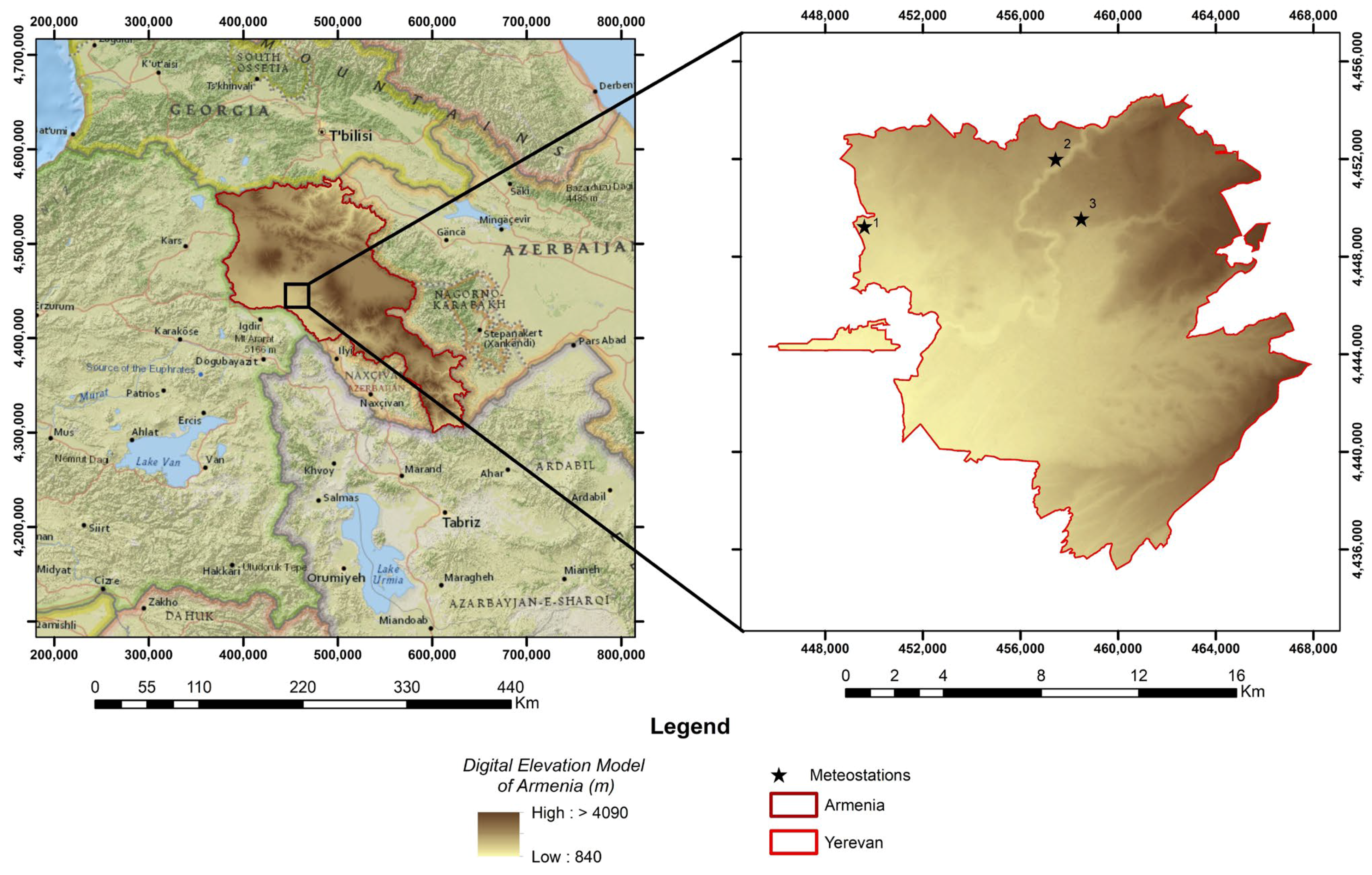
2.1. Study Area
2.2. Input Data
2.2.1. Ground-Based Data
2.2.2. Remote Sensing Data and Topographic Information
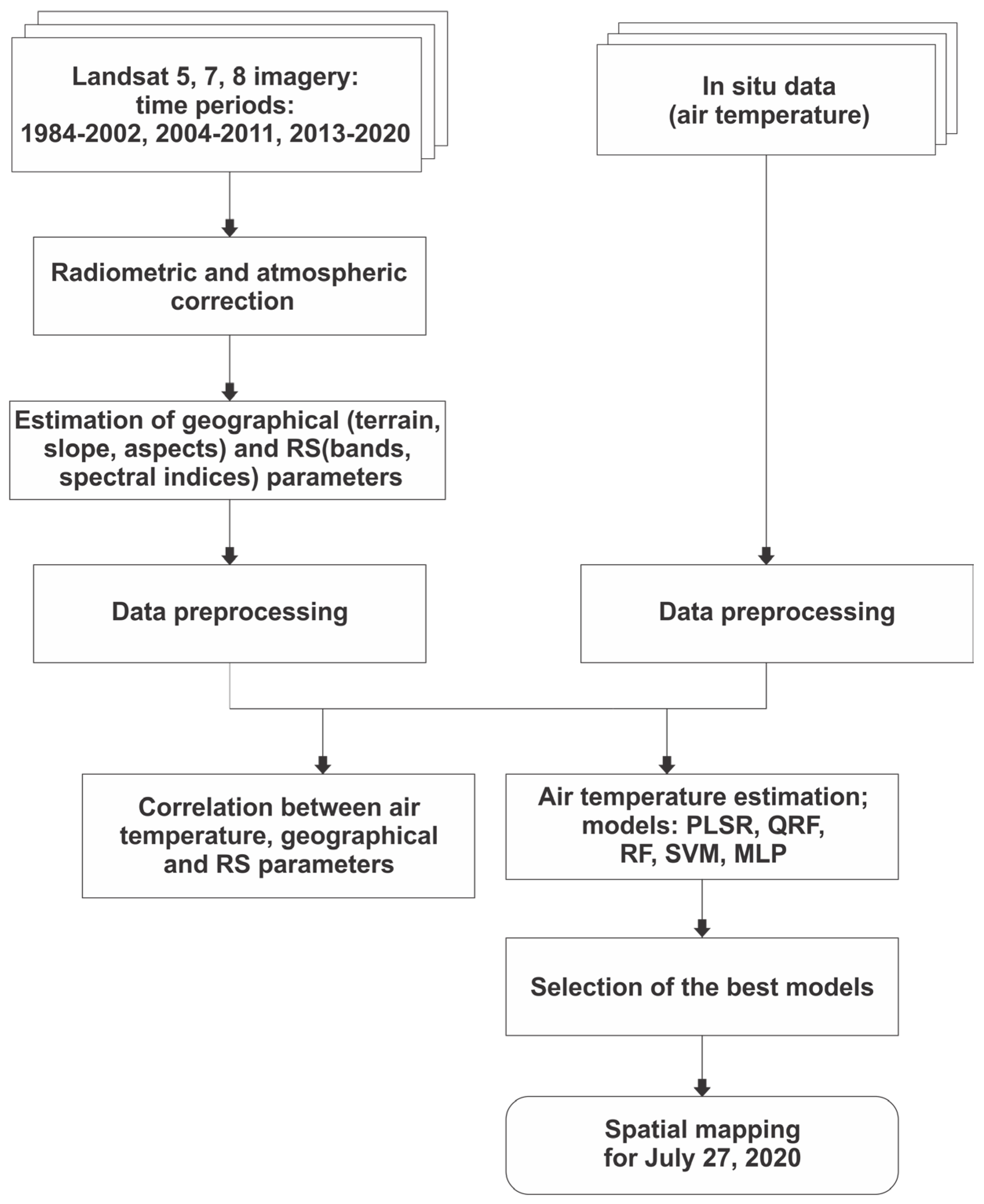
2.3. Methods and Algorithms
2.3.1. Statistical Analyses and ML Modeling
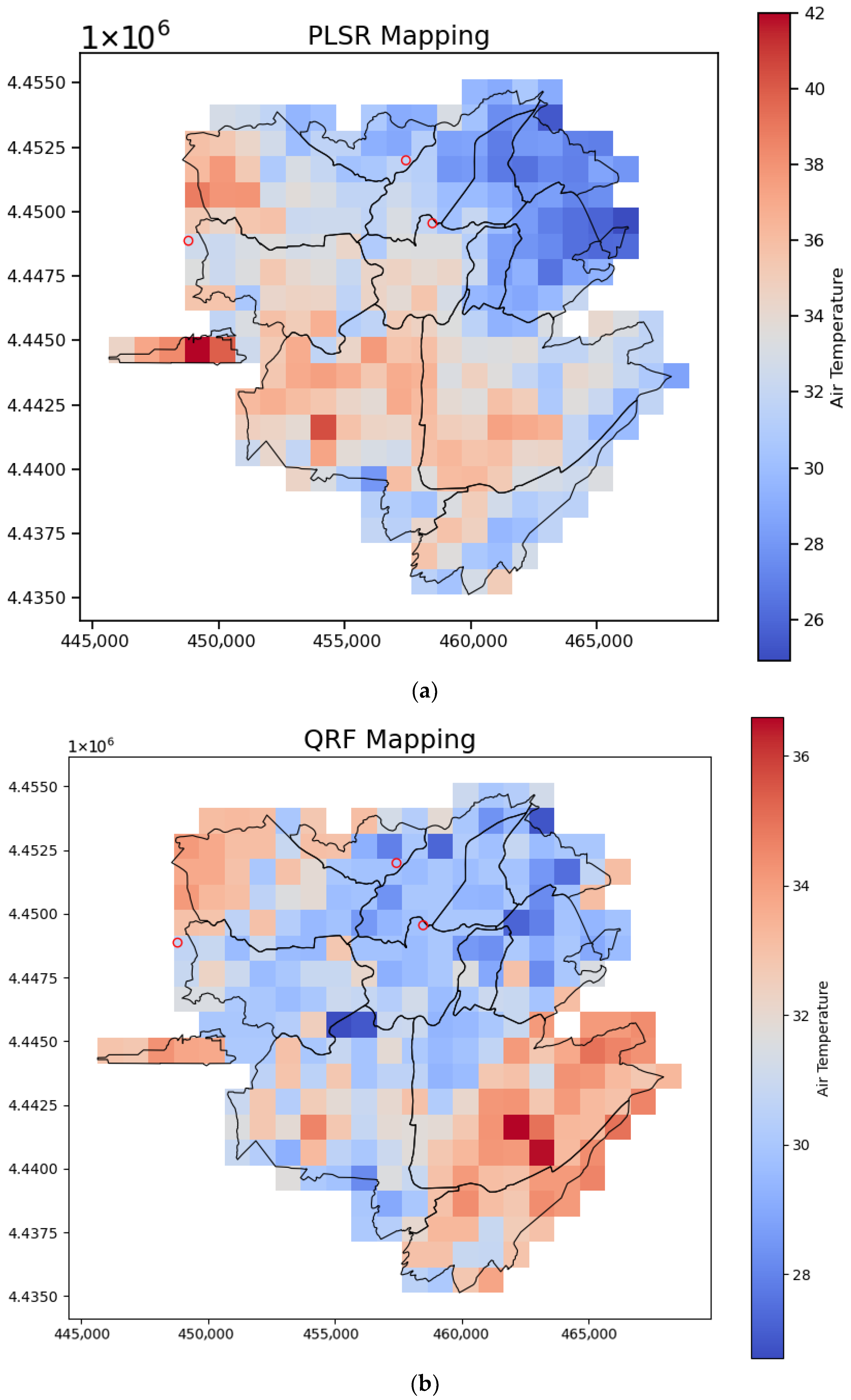
2.3.2. Spatial Mapping Method
3. Results and Discussions
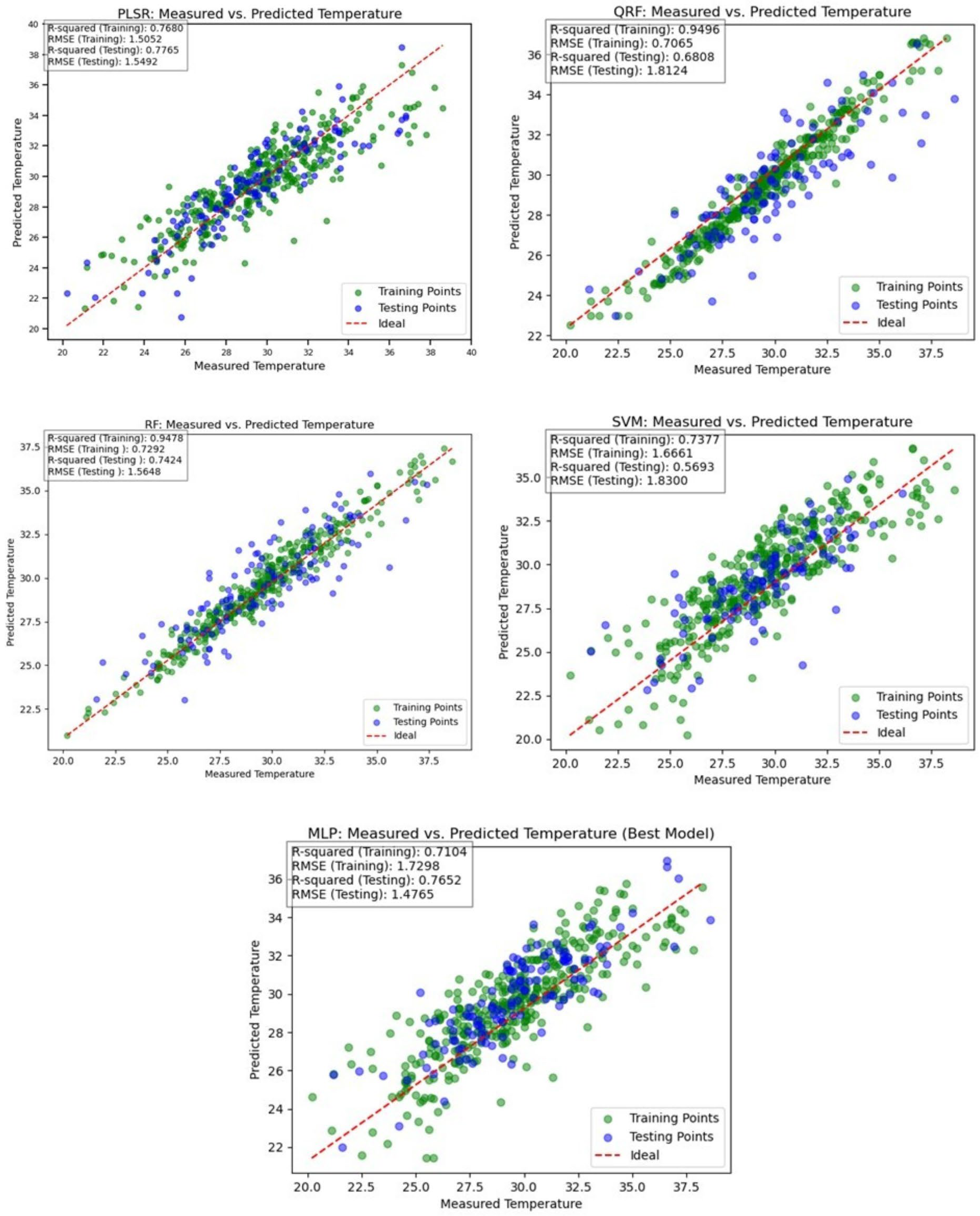
3.1. Performance of Algorithms
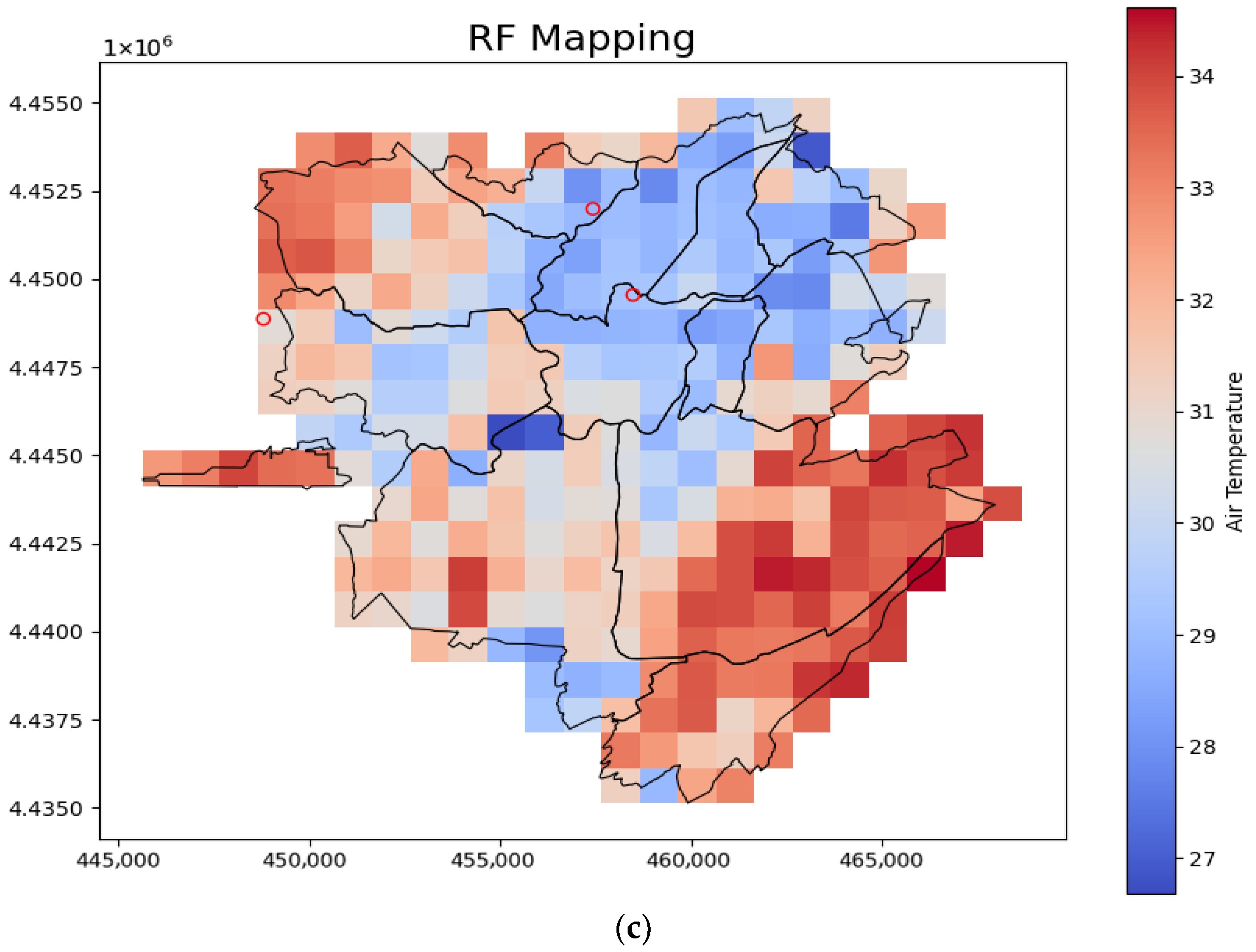
3.2. Mapping of Urban Tair
4. Limitations
5. Conclusions
- Integrating more diverse and higher-resolution remote sensing data, such as hyperspectral imagery or LiDAR data, could further refine Tair predictions, especially in highly heterogeneous urban landscapes.
- Integrating additional environmental variables including wind rose and precipitation.
- Investigating the diurnal and seasonal variations in the urban heat island effect using these advanced mapping techniques would provide a more dynamic understanding of urban climate of Yerevan.
- Also, the developed methodologies could be applied to other complex urban environments with similar data scarcity challenges, contributing to boarder efforts in climate change adaptation and urban planning.
Author Contributions
Funding
Institutional Review Board Statement
Informed Consent Statement
Data Availability Statement
Acknowledgments
Conflicts of Interest
Abbreviations
| LST | Land surface temperature |
| ML | Machine learning |
| PLSR | Partial Least-Squares Regression |
| RF | Random forest |
| QRF | Quantile regression forest |
| SVM | Support vector machine |
| MLP | MultiLayer Perception |
| RMSE | Root Mean Square Error |
| UHI | Urban Heat Island |
| TIR | Thermal InfraRed |
| TVX | Temperature Vegetation Index |
| RS | Remote Sensing |
| GIS | Geographic Information Systems |
| ANN | Artificial Neural Network |
| GEE | Google Earth Engine |
| NDVI | Normalized Difference Vegetation Index |
| NDWI | Normalized Difference Water Index |
| IBI | Index-based Build-up Index |
| SAVI | Soil-Adjusted Vegetation Index |
| DEM | Digital Elevation Model |
| NIR | Near Infrared |
| SWIR | Shortwave Infrared |
| DOY | Day of Year |
| VIP | Variable Importance in Projection |
References
- Trenberth, K.E.; Zhang, Y.; Fasullo, J.T.; Taguchi, S. Climate Variability and Relationships between Top-of-Atmosphere Radiation and Temperatures on Earth. J. Geophys. Res. Atmos. 2015, 120, 3642–3659. [Google Scholar] [CrossRef]
- Ginzburg, A.S. Regional Air Temperature Maxima and the Possibility of Their Simple Energy-Balance Estimates. Izv. Atmos. Ocean. Phys. 2011, 47, 665–671. [Google Scholar] [CrossRef]
- Mahmoud, S.H.; Gan, T.Y. Impact of Anthropogenic Climate Change and Human Activities on Environment and Ecosystem Services in Arid Regions. Sci. Total Environ. 2018, 633, 1329–1344. [Google Scholar] [CrossRef]
- Kinney, P.L. Climate Change, Air Quality, and Human Health. Am. J. Prev. Med. 2008, 35, 459–467. [Google Scholar] [CrossRef]
- Mirzaei, P.A. Recent Challenges in Modeling of Urban Heat Island. Sustain. Cities Soc. 2015, 19, 200–206. [Google Scholar] [CrossRef]
- Heisler, G.M.; Brazel, A.J. The Urban Physical Environment: Temperature and Urban Heat Islands. In Urban Ecosystem Ecology; John Wiley & Sons, Ltd.: Hoboken, NJ, USA, 2010; pp. 29–56. [Google Scholar]
- Ding, L.; Zhou, J.; Zhang, X.; Liu, S.; Cao, R. Downscaling of Surface Air Temperature over the Tibetan Plateau Based on DEM. Int. J. Appl. Earth Obs. Geoinf. 2018, 73, 136–147. [Google Scholar] [CrossRef]
- dos Santos, R.S. Estimating Spatio-Temporal Air Temperature in London (UK) Using Machine Learning and Earth Observation Satellite Data. Int. J. Appl. Earth Obs. Geoinf. 2020, 88, 102066. [Google Scholar] [CrossRef]
- Nichol, J.E.; To, P.H. Temporal Characteristics of Thermal Satellite Images for Urban Heat Stress and Heat Island Mapping. ISPRS J. Photogramm. Remote Sens. 2012, 74, 153–162. [Google Scholar] [CrossRef]
- Rahmatollahi, N.; Wang, Z.-H.; Wang, Y.; Yang, X. Machine Learning and Causal Attribution of Urban Heat in the Phoenix Metropolitan. Sustain. Cities Soc. 2026, 137, 107145. [Google Scholar] [CrossRef]
- Abbas, A.; He, Q.; Jin, L.; Li, J.; Salam, A.; Lu, B.; Yasheng, Y. Spatio-Temporal Changes of Land Surface Temperature and the Influencing Factors in the Tarim Basin, Northwest China. Remote Sens. 2021, 13, 3792. [Google Scholar] [CrossRef]
- Voogt, J.A.; Oke, T.R. Thermal Remote Sensing of Urban Climates. Remote Sens. Environ. 2003, 86, 370–384. [Google Scholar] [CrossRef]
- Vogt, J.V.; Viau, A.A.; Paquet, F. Mapping Regional Air Temperature Fields Using Satellite-Derived Surface Skin Temperatures. Int. J. Climatol. 1997, 17, 1559–1579. [Google Scholar] [CrossRef]
- Zakšek, K.; Schroedter-Homscheidt, M. Parameterization of Air Temperature in High Temporal and Spatial Resolution from a Combination of the SEVIRI and MODIS Instruments. ISPRS J. Photogramm. Remote Sens. 2009, 64, 414–421. [Google Scholar] [CrossRef]
- Benali, A.; Carvalho, A.C.; Nunes, J.P.; Carvalhais, N.; Santos, A. Estimating Air Surface Temperature in Portugal Using MODIS LST Data. Remote Sens. Environ. 2012, 124, 108–121. [Google Scholar] [CrossRef]
- Chen, X.; Zhang, Y. Impacts of Urban Surface Characteristics on Spatiotemporal Pattern of Land Surface Temperature in Kunming of China. Sustain. Cities Soc. 2017, 32, 87–99. [Google Scholar] [CrossRef]
- Yang, G.; Sun, W.; Shen, H.; Meng, X.; Li, J. An Integrated Method for Reconstructing Daily MODIS Land Surface Temperature Data. IEEE J. Sel. Top. Appl. Earth Obs. Remote Sens. 2019, 12, 1026–1040. [Google Scholar] [CrossRef]
- Chen, Y.; Amani-Beni, M.; Chen, C.; Liang, Y.; Li, J.; Yang, L. Projection of Urban Land Surface Temperature: An Inter- and Intra-Annual Modeling Approach. Urban Clim. 2023, 51, 101637. [Google Scholar] [CrossRef]
- Ho, H.C.; Knudby, A.; Sirovyak, P.; Xu, Y.; Hodul, M.; Henderson, S.B. Mapping Maximum Urban Air Temperature on Hot Summer Days. Remote Sens. Environ. 2014, 154, 38–45. [Google Scholar] [CrossRef]
- Vancutsem, C.; Ceccato, P.; Dinku, T.; Connor, S.J. Evaluation of MODIS Land Surface Temperature Data to Estimate Air Temperature in Different Ecosystems over Africa. Remote Sens. Environ. 2010, 114, 449–465. [Google Scholar] [CrossRef]
- Weng, Q. Thermal Infrared Remote Sensing for Urban Climate and Environmental Studies: Methods, Applications, and Trends. ISPRS J. Photogramm. Remote Sens. 2009, 64, 335–344. [Google Scholar] [CrossRef]
- Agam, N.; Kustas, W.P.; Anderson, M.C.; Li, F.; Neale, C.M.U. A Vegetation Index Based Technique for Spatial Sharpening of Thermal Imagery. Remote Sens. Environ. 2007, 107, 545–558. [Google Scholar] [CrossRef]
- Nieto, H.; Sandholt, I.; Aguado, I.; Chuvieco, E.; Stisen, S. Air Temperature Estimation with MSG-SEVIRI Data: Calibration and Validation of the TVX Algorithm for the Iberian Peninsula. Remote Sens. Environ. 2011, 115, 107–116. [Google Scholar] [CrossRef]
- Ozelkan, E.; Bagis, S.; Ozelkan, E.C.; Ustundag, B.B.; Yucel, M.; Ormeci, C. Spatial Interpolation of Climatic Variables Using Land Surface Temperature and Modified Inverse Distance Weighting. Int. J. Remote Sens. 2015, 36, 1000–1025. [Google Scholar] [CrossRef]
- Parmentier, B.; McGill, B.J.; Wilson, A.M.; Regetz, J.; Jetz, W.; Guralnick, R.; Tuanmu, M.-N.; Schildhauer, M. Using Multi-Timescale Methods and Satellite-Derived Land Surface Temperature for the Interpolation of Daily Maximum Air Temperature in Oregon. Int. J. Climatol. 2015, 35, 3862–3878. [Google Scholar] [CrossRef]
- Li, X.Y.; Li, Z.; Zhang, Q.Q.; Zhou, P.X.; Huang, W. Prediction of Long-Term Near-Surface Temperature Based on NA-CORDEX Output. J. Environ. Inform. Lett. 2019, 2, 10–18. [Google Scholar] [CrossRef]
- Florio, E.N.; Lele, S.R.; Chi Chang, Y.; Sterner, R.; Glass, G.E. Integrating AVHRR Satellite Data and NOAA Ground Observations to Predict Surface Air Temperature: A Statistical Approach. Int. J. Remote Sens. 2004, 25, 2979–2994. [Google Scholar] [CrossRef]
- Bechtel, B.; Zakšek, K.; Oßenbrügge, J.; Kaveckis, G.; Böhner, J. Towards a Satellite Based Monitoring of Urban Air Temperatures. Sustain. Cities Soc. 2017, 34, 22–31. [Google Scholar] [CrossRef]
- Yang, Y.Z.; Cai, W.H.; Yang, J. Evaluation of MODIS Land Surface Temperature Data to Estimate Near-Surface Air Temperature in Northeast China. Remote Sens. 2017, 9, 410. [Google Scholar] [CrossRef]
- Good, E.J.; Ghent, D.J.; Bulgin, C.E.; Remedios, J.J. A Spatiotemporal Analysis of the Relationship between Near-Surface Air Temperature and Satellite Land Surface Temperatures Using 17 Years of Data from the ATSR Series. J. Geophys. Res. Atmos. 2017, 122, 9185–9210. [Google Scholar] [CrossRef]
- Xu, Y.; Knudby, A.; Ho, H.C. Estimating Daily Maximum Air Temperature from MODIS in British Columbia, Canada. Int. J. Remote Sens. 2014, 35, 8108–8121. [Google Scholar] [CrossRef]
- Liu, L.; Zhang, Y. Urban Heat Island Analysis Using the Landsat TM Data and ASTER Data: A Case Study in Hong Kong. Remote Sens. 2011, 3, 1535–1552. [Google Scholar] [CrossRef]
- Yoo, C.; Im, J.; Park, S.; Quackenbush, L.J. Estimation of Daily Maximum and Minimum Air Temperatures in Urban Landscapes Using MODIS Time Series Satellite Data. ISPRS J. Photogramm. Remote Sens. 2018, 137, 149–162. [Google Scholar] [CrossRef]
- Rasul, A.; Balzter, H.; Smith, C. Applying a Normalized Ratio Scale Technique to Assess Influences of Urban Expansion on Land Surface Temperature of the Semi-Arid City of Erbil. Int. J. Remote Sens. 2017, 38, 3960–3980. [Google Scholar] [CrossRef]
- Nikoloudakis, N.; Stagakis, S.; Mitraka, Z.; Kamarianakis, Y.; Chrysoulakis, N. Spatial Interpolation of Urban Air Temperatures Using Satellite-Derived Predictors. Theor. Appl. Clim. 2020, 141, 657–672. [Google Scholar] [CrossRef]
- Cristóbal, J.; Jiménez-Muñoz, J.C.; Prakash, A.; Mattar, C.; Skoković, D.; Sobrino, J.A. An Improved Single-Channel Method to Retrieve Land Surface Temperature from the Landsat-8 Thermal Band. Remote Sens. 2018, 10, 431. [Google Scholar] [CrossRef]
- Mutiibwa, D.; Strachan, S.; Albright, T. Land Surface Temperature and Surface Air Temperature in Complex Terrain. IEEE J. Sel. Top. Appl. Earth Obs. Remote Sens. 2015, 8, 4762–4774. [Google Scholar] [CrossRef]
- Orellana-Samaniego, M.L.; Ballari, D.; Guzman, P.; Ospina, J.E. Estimating Monthly Air Temperature Using Remote Sensing on a Region with Highly Variable Topography and Scarce Monitoring in the Southern Ecuadorian Andes. Theor. Appl. Clim. 2021, 144, 949–966. [Google Scholar] [CrossRef]
- Cifuentes, J.; Marulanda, G.; Bello, A.; Reneses, J. Air Temperature Forecasting Using Machine Learning Techniques: A Review. Energies 2020, 13, 4215. [Google Scholar] [CrossRef]
- Agathangelidis, I.; Cartalis, C.; Santamouris, M. Estimation of Air Temperatures for the Urban Agglomeration of Athens with the Use of Satellite Data. Geoinform. Geostat. Overv. 2016, 4, 2. [Google Scholar] [CrossRef]
- Meliho, M.; Khattabi, A.; Zejli, D.; Orlando, C.A.; Dansou, C.E. Artificial Intelligence and Remote Sensing for Spatial Prediction of Daily Air Temperature: Case Study of Souss Watershed of Morocco. Geo-Spat. Inf. Sci. 2022, 25, 244–258. [Google Scholar] [CrossRef]
- Zhang, G.; Bateni, S.M.; Jun, C.; Khoshkam, H.; Band, S.S.; Mosavi, A. Feasibility of Random Forest and Multivariate Adaptive Regression Splines for Predicting Long-Term Mean Monthly Dew Point Temperature. Front. Environ. Sci. 2022, 10, 826165. [Google Scholar] [CrossRef]
- Tepanosyan, G.; Muradyan, V.; Hovsepyan, A.; Pinigin, G.; Medvedev, A.; Asmaryan, S. Studying Spatial-Temporal Changes and Relationship of Land Cover and Surface Urban Heat Island Derived through Remote Sensing in Yerevan, Armenia. Build. Environ. 2021, 187, 107390. [Google Scholar] [CrossRef]
- Riley, S.J.; De Gloria, S.D.; Elliot, R. A Terrain Ruggedness Index That Quantifies Topographic Heterogeneity. Intermt. J. Sci. 1999, 5, 23–27. [Google Scholar]
- Zhang, H.; Zhang, F.; Ye, M.; Che, T.; Zhang, G. Estimating Daily Air Temperatures over the Tibetan Plateau by Dynamically Integrating MODIS LST Data. J. Geophys. Res. Atmos. 2016, 121, 11,425–11,441. [Google Scholar] [CrossRef]
- Noi, P.T.; Kappas, M.; Degener, J. Estimating Daily Maximum and Minimum Land Air Surface Temperature Using MODIS Land Surface Temperature Data and Ground Truth Data in Northern Vietnam. Remote Sens. 2016, 8, 1002. [Google Scholar] [CrossRef]
- Otgonbayar, M.; Atzberger, C.; Mattiuzzi, M.; Erdenedalai, A. Estimation of Climatologies of Average Monthly Air Temperature over Mongolia Using MODIS Land Surface Temperature (LST) Time Series and Machine Learning Techniques. Remote Sens. 2019, 11, 2588. [Google Scholar] [CrossRef]
- Tepanosyan, G.; Asmaryan, S.; Muradyan, V.; Avetisyan, R.; Hovsepyan, A.; Khlghatyan, A.; Ayvazyan, G.; Dell’Acqua, F. Machine Learning-Based Modeling of Air Temperature in the Complex Environment of Yerevan City, Armenia. Remote Sens. 2023, 15, 2795. [Google Scholar] [CrossRef]
- Belgiu, M.; Drăguţ, L. Random Forest in Remote Sensing: A Review of Applications and Future Directions. ISPRS J. Photogramm. Remote Sens. 2016, 114, 24–31. [Google Scholar] [CrossRef]
- Breiman, L. Random Forests. Mach. Learn. 2001, 45, 5–32. [Google Scholar] [CrossRef]
- Meinshausen, N. Quantile Regression Forests. J. Mach. Learn. Res. 2006, 7, 983–999. [Google Scholar]
- Awad, M.; Khanna, R. Support Vector Machines for Classification. In Efficient Learning Machines: Theories, Concepts, and Applications for Engineers and System Designers; Awad, M., Khanna, R., Eds.; Apress: Berkeley, CA, USA, 2015; pp. 39–66. [Google Scholar]
- Atkinson, P.M.; Tatnall, A.R.L. Introduction Neural Networks in Remote Sensing. Int. J. Remote Sens. 1997, 18, 699–709. [Google Scholar] [CrossRef]
- Hastie, T.; Tibshirani, R.; Friedman, J. The Elements of Statistical Learning; Springer Series in Statistics; Springer: New York, NY, USA, 2009. [Google Scholar]



| Category | Variable | Description/Source | Relevance to Tair Assessment |
|---|---|---|---|
| Spectral Bands (Landsat 4–8) | Blue, Green, Red, NIR, SWIR1, SWIR2 | Surface reflectance bands from Landsat missions (TM, ETM+, OLI/TIRS) | Represent surface material and albedo differences; influence surface energy absorption and heat emission patterns. |
| Spectral Indices | NDVI (Normalized Difference Vegetation Index) | (NIR − Red)/(NIR + Red) | Indicates vegetation density; higher NDVI corresponds to cooler areas due to evapotranspiration. |
| NDWI (Normalized Difference Water Index) | (NIR − SWIR)/(NIR + SWIR) | Detects water and moisture content; areas with higher NDWI are cooler. | |
| IBI-SAVI (Index-Based Built-Up Index and Soil-Adjusted Vegetation Index) | IBI-SAVI = (((NDBI + 1) − ((SAVI + 1) + (MNDWI + 1))/2))/(((NDBI + 1) + ((SAVI + 1) + (MNDWI + 1))/2)) | Captures urban surface composition; higher IBI-SAVI values are associated with greater impervious surface coverage and elevated Tair. | |
| Thermal Variable | LST (Land Surface Temperature) | Derived from Landsat TIR bands (OLI/TIRS) | Strongest satellite-based predictor of near-surface Tair; directly related to surface–atmosphere heat exchange. |
| Topographic Factors (DEM-derived) | Elevation | From digital elevation model (DEM) | Affects Tair through lapse rate; higher elevations are typically cooler. |
| Slope | DEM-derived gradient | Influences insolation and air flow; steeper slopes may experience reduced solar heating. | |
| Aspect | DEM-derived orientation | Controls solar radiation exposure; south-facing slopes in Yerevan receive more sunlight and are warmer. | |
| Terrain Ruggedness Index | From DEM [44] | Quantifies surface heterogeneity; affects local wind and heat distribution. | |
| Solar Radiation | Computed from DEM using solar geometry | Major driver of surface and Tair; varies with slope, aspect, and season. | |
| Statistical Metrics | Mean of each variable listed above | Mean value of variable within 1 km grid cell | Captures average environmental condition influencing Tair. |
| Standard deviation of each variable listed above | SD within 1 km grid cell | Represents local variability and surface heterogeneity, which influence microclimate and heat retention. | |
| Temporal Factor | DOY (Day of Year) | Acquisition day of Landsat image | Reflects seasonal variability in solar radiation and atmospheric conditions. |
| ML Models | Final Hyperparameter Settings Parameters |
|---|---|
| PLSR |
|
| RF |
|
| QRF |
|
| SVM |
|
| MLP |
|
| ML Model | R2train | R2test | RMSEtrain(°C) | RMSEtest(°C) |
|---|---|---|---|---|
| QRF | 0.95 | 0.68 | 0.71 | 1.81 |
| RF | 0.94 | 0.74 | 0.73 | 0.56 |
| SVM | 0.74 | 0.56 | 1.66 | 1.83 |
| MLP | 0.71 | 0.76 | 1.73 | 1.47 |
| PLSR | 0.77 | 0.78 | 1.50 | 1.54 |
Disclaimer/Publisher’s Note: The statements, opinions and data contained in all publications are solely those of the individual author(s) and contributor(s) and not of MDPI and/or the editor(s). MDPI and/or the editor(s) disclaim responsibility for any injury to people or property resulting from any ideas, methods, instructions or products referred to in the content. |
© 2026 by the authors. Licensee MDPI, Basel, Switzerland. This article is an open access article distributed under the terms and conditions of the Creative Commons Attribution (CC BY) license.
Share and Cite
Muradyan, V.; Avetisyan, R.; Asmaryan, S.; Khlghatyan, A.; Hovsepyan, A.; Tepanosyan, G.; Bergamaschi, A.; Dell’Acqua, F. Integrated Remote Sensing and Machine Learning for Urban Air Temperature Assessment and Mapping in Highly Heterogeneous Environments. Urban Sci. 2026, 10, 257. https://doi.org/10.3390/urbansci10050257
Muradyan V, Avetisyan R, Asmaryan S, Khlghatyan A, Hovsepyan A, Tepanosyan G, Bergamaschi A, Dell’Acqua F. Integrated Remote Sensing and Machine Learning for Urban Air Temperature Assessment and Mapping in Highly Heterogeneous Environments. Urban Science. 2026; 10(5):257. https://doi.org/10.3390/urbansci10050257
Chicago/Turabian StyleMuradyan, Vahagn, Rima Avetisyan, Shushanik Asmaryan, Anahit Khlghatyan, Azatuhi Hovsepyan, Garegin Tepanosyan, Andrea Bergamaschi, and Fabio Dell’Acqua. 2026. "Integrated Remote Sensing and Machine Learning for Urban Air Temperature Assessment and Mapping in Highly Heterogeneous Environments" Urban Science 10, no. 5: 257. https://doi.org/10.3390/urbansci10050257
APA StyleMuradyan, V., Avetisyan, R., Asmaryan, S., Khlghatyan, A., Hovsepyan, A., Tepanosyan, G., Bergamaschi, A., & Dell’Acqua, F. (2026). Integrated Remote Sensing and Machine Learning for Urban Air Temperature Assessment and Mapping in Highly Heterogeneous Environments. Urban Science, 10(5), 257. https://doi.org/10.3390/urbansci10050257