
The Inventory and Quantitative Assessment of Geodiversity as Strategic Tools for Promoting Sustainable Geoconservation and Geo-Education in the Peloritani Mountains (Italy)


Abstract
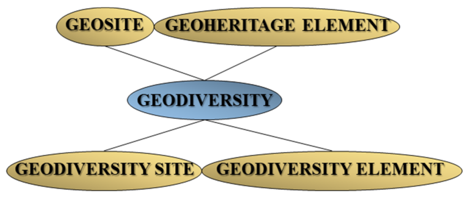
1. Introduction
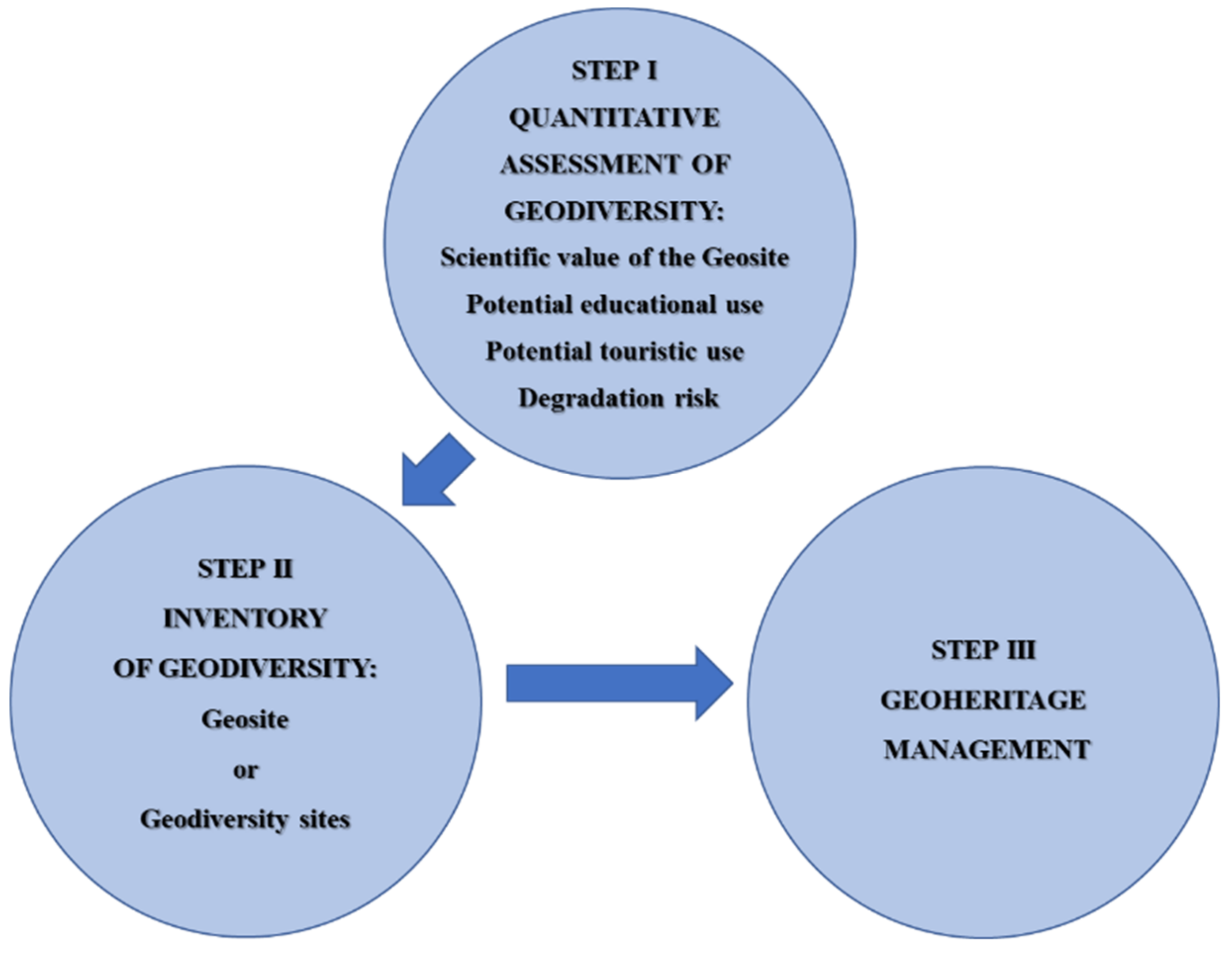
2. Materials and Methods
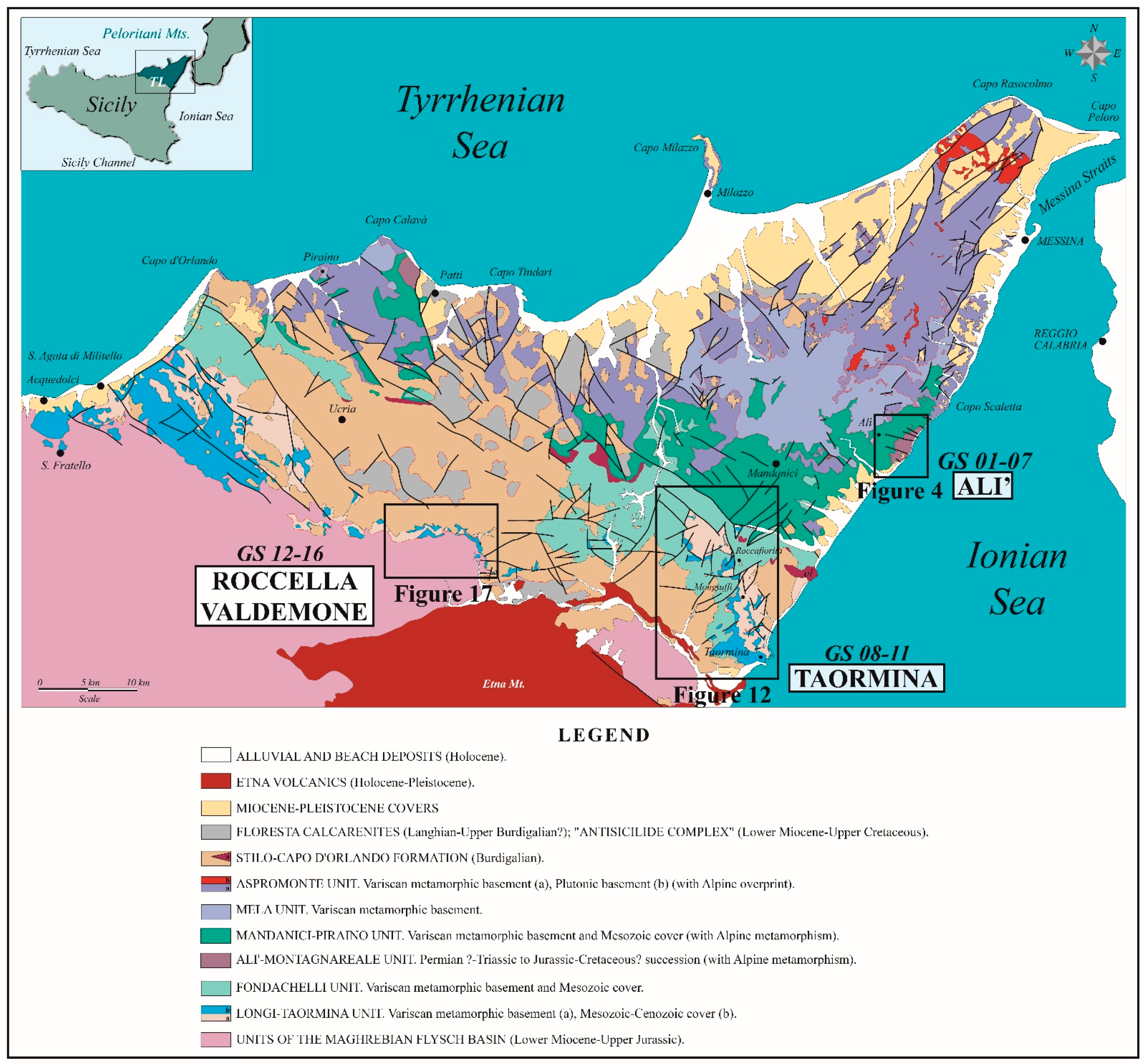
3. Results
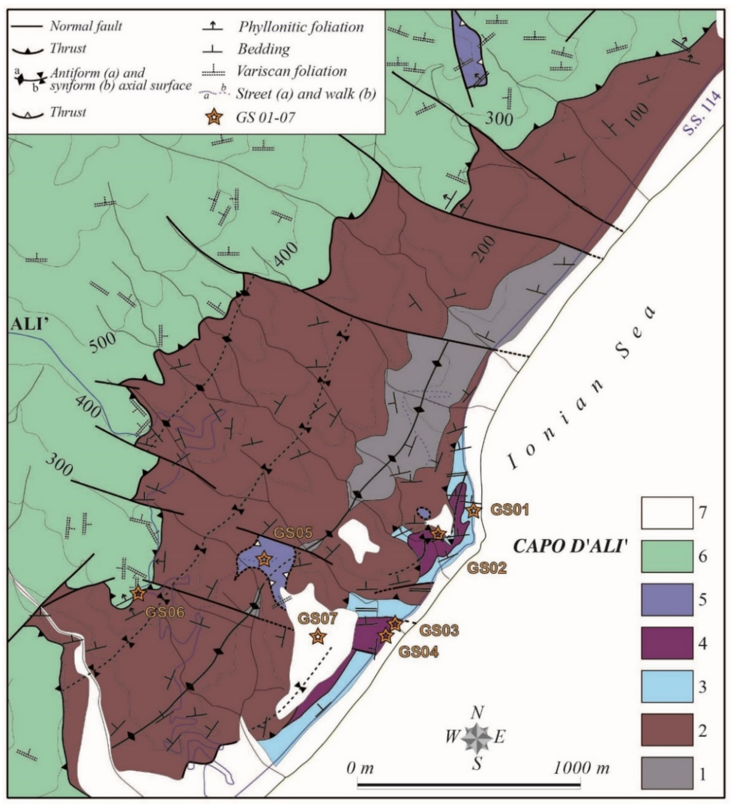
- GS01—Alpine syn-orogenic compression and extension at Capo d’Alì.
- GS02—Thrust at Rio Schiavo.
- GS03—Boudin-like structures at Rio Impisi.
- GS04—Alpine syn-orogenic compression and extension at Rio Impisi.
- GS05—Modderino klippe.
- GS06—Thrust of the Mandanici Unit at Puntale Serro.
- GS07—Marine terrace at Modderino.
- 8.
- GS08—Thrust at the Monte Veneretta—Monte Pernice ridge.
- 9.
- GS09—CS structures at Monte Pernice.
- 10.
- GS10—Fold at Monte Galfa.
- 11.
- GS11—Thrust of the Fondachelli Unit at Monte Galfa.
- 12.
- GS12—Peloritani Thrust Front in the central sector of the Taormina Line.
- 13.
- GS13—Paleozoic pillow lavas at Rocca Licopeti.
- 14.
- GS14—Silurian to Devonian conodonts in the Favoscuro west section.
- 15.
- GS15—Devonian conodonts in the Favoscuro east section.
- 16.
- GS16—Devonian conodonts in the Pizzo Leo section.
3.1. Geological Frameworks
- i.
- Alpine syn-orogenic compression and extension;
- ii.
- Alpine thrust tectonics;
- iii.
- Miocene block rotations along arc-like structures;
- iv.
- Paleozoic stratigraphy and guide fossils;
- v.
- Pleistocene uplift of the chain and related genesis of marine terraces.
3.1.1. Alpine Syn-Orogenic Compression and Extension
3.1.2. Alpine Thrust Tectonics
3.1.3. Miocene Block Rotations along the Arc-like Structures
3.1.4. Paleozoic Stratigraphy and Guide Fossils
3.1.5. Pleistocene Uplift of the Chain and the Related Genesis of Marine Terraces
3.2. Quantitative Assessment of the Scientific Value of the Geodiversity in the Alì, Taormina, and Roccella Valdemone Areas

| INDICATORS/ID | GS01 | GS02 | GS03 | GS04 | GS05 | GS06 | GS07 | GS08 |
|---|---|---|---|---|---|---|---|---|
| Representativeness (30) | 4 | 2 | 4 | 4 | 2 | 2 | 2 | 4 |
| Key locality (20) | 2 | 1 | 2 | 2 | 1 | 1 | 1 | 2 |
| Scientific knowledge (5) | 4 | 2 | 4 | 4 | 4 | 4 | 4 | 4 |
| Integrity (15) | 4 | 4 | 4 | 4 | 2 | 2 | 4 | 4 |
| Geological diversity (5) | 2 | 1 | 2 | 2 | 1 | 1 | 1 | 1 |
| Rarity (15) | 4 | 4 | 4 | 4 | 4 | 4 | 2 | 4 |
| Use limitations (5) | 4 | 4 | 4 | 4 | 4 | 4 | 4 | 4 |
| Weighted sum of the scientific value | 3.45 | 2.5 | 3.4 | 3.45 | 2.6 | 2.6 | 2.4 | 3.4 |
| INDICATORS/ID | GS09 | GS10 | GS11 | GS12 | GS13 | GS14 | GS15 | GS16 |
| Representativeness (30) | 2 | 4 | 4 | 4 | 4 | 4 | 4 | 4 |
| Key locality (20) | 1 | 2 | 2 | 2 | 2 | 2 | 2 | 2 |
| Scientific knowledge (5) | 4 | 4 | 4 | 4 | 4 | 4 | 4 | 4 |
| Integrity (15) | 2 | 4 | 4 | 4 | 4 | 4 | 4 | 4 |
| Geological diversity (5) | 1 | 2 | 1 | 1 | 1 | 2 | 2 | 2 |
| Rarity (15) | 4 | 4 | 4 | 2 | 2 | 4 | 2 | 2 |
| Use limitations (5) | 4 | 4 | 4 | 4 | 4 | 2 | 4 | 4 |
| Weighted sum of the scientific value | 2.2 | 3.6 | 3.4 | 3 | 3 | 3.5 | 3.2 | 3.2 |
3.3. Quantitative Assessment of the Potential Educational Use in the Alì, Taormina, and Roccella Valdemone Areas
| INDICATORS/ID | GS01 | GS02 | GS03 | GS04 | GS05 | GS06 | GS07 | GS08 |
|---|---|---|---|---|---|---|---|---|
| Vulnerability (10) | 1 | 4 | 4 | 1 | 3 | 3 | 3 | 4 |
| Accessibility (10) | 4 | 4 | 4 | 4 | 4 | 4 | 4 | 4 |
| Use limitations (5) | 4 | 4 | 4 | 4 | 4 | 4 | 4 | 4 |
| Safety (10) | 2 | 2 | 2 | 2 | 2 | 2 | 2 | 2 |
| Logistics (5) | 4 | 4 | 4 | 4 | 4 | 4 | 4 | 4 |
| Density population (5) | 3 | 3 | 3 | 3 | 3 | 1 | 1 | 1 |
| Association with other values (5) | 4 | 4 | 4 | 4 | 4 | 4 | 4 | 4 |
| Scenery (5) | 1 | 1 | 1 | 1 | 1 | 1 | 1 | 1 |
| Uniqueness (5) | 4 | 4 | 4 | 4 | 4 | 4 | 2 | 4 |
| Observation conditions (10) | 3 | 4 | 4 | 3 | 4 | 4 | 4 | 4 |
| Didactic potential (20) | 4 | 4 | 4 | 4 | 4 | 4 | 4 | 4 |
| Geological diversity (10) | 4 | 4 | 4 | 4 | 4 | 3 | 3 | 4 |
| Weighted sum of the educational use | 3.2 | 3.6 | 3.6 | 3.2 | 3.5 | 3.3 | 3.2 | 3.5 |
| INDICATORS/ID | GS09 | GS10 | GS11 | GS12 | GS13 | GS14 | GS15 | GS16 |
| Vulnerability (10) | 3 | 4 | 3 | 3 | 3 | 4 | 3 | 4 |
| Accessibility (10) | 4 | 4 | 4 | 3 | 3 | 3 | 3 | 3 |
| Use limitations (5) | 4 | 4 | 4 | 4 | 4 | 2 | 4 | 4 |
| Safety (10) | 2 | 2 | 2 | 2 | 2 | 2 | 2 | 2 |
| Logistics (5) | 4 | 4 | 4 | 4 | 4 | 4 | 4 | 4 |
| Density population (5) | 1 | 2 | 2 | 1 | 1 | 1 | 1 | 1 |
| Association with other values (5) | 3 | 3 | 3 | 4 | 4 | 4 | 4 | 4 |
| Scenery (5) | 1 | 1 | 1 | 1 | 1 | 1 | 1 | 1 |
| Uniqueness (5) | 4 | 4 | 4 | 4 | 4 | 4 | 4 | 4 |
| Observation conditions (10) | 4 | 4 | 4 | 4 | 4 | 4 | 4 | 4 |
| Didactic potential (20) | 4 | 4 | 4 | 4 | 4 | 4 | 4 | 4 |
| Geological diversity (10) | 3 | 4 | 3 | 3 | 3 | 3 | 3 | 3 |
| Weighted sum of the educational use | 3.25 | 3.5 | 3.3 | 3.3 | 3.2 | 3.2 | 3.2 | 3.3 |
3.4. Quantitative Assessment of the Potential Touristic Use in the Alì, Taormina, and Roccella Valdemone Areas
| INDICATORS/ID | GS01 | GS02 | GS03 | GS04 | GS05 | GS06 | GS07 | GS08 |
|---|---|---|---|---|---|---|---|---|
| Vulnerability (10) | 1 | 4 | 4 | 1 | 3 | 3 | 3 | 4 |
| Accessibility (10) | 4 | 4 | 4 | 4 | 4 | 4 | 4 | 4 |
| Use limitations (5) | 4 | 4 | 4 | 4 | 4 | 4 | 4 | 4 |
| Safety (10) | 2 | 2 | 2 | 2 | 2 | 2 | 2 | 2 |
| Logistics (5) | 4 | 4 | 4 | 4 | 4 | 4 | 4 | 4 |
| Density population (5) | 3 | 3 | 3 | 3 | 3 | 1 | 1 | 1 |
| Association with other values (5) | 4 | 4 | 4 | 4 | 4 | 4 | 4 | 4 |
| Scenery (5) | 1 | 1 | 1 | 1 | 1 | 1 | 1 | 1 |
| Uniqueness (5) | 4 | 4 | 4 | 4 | 4 | 4 | 2 | 4 |
| Observation conditions (10) | 3 | 4 | 4 | 3 | 4 | 4 | 4 | 4 |
| Interpretative potential (10) | 1 | 4 | 4 | 1 | 1 | 4 | 4 | 4 |
| Economic level (5) | 1 | 1 | 1 | 1 | 1 | 1 | 1 | 1 |
| Proximity of recreational areas (5) | 4 | 4 | 4 | 4 | 4 | 4 | 4 | 4 |
| Weighted sum of the touristic use | 2.35 | 3.05 | 3.05 | 2.35 | 2.65 | 2.85 | 2.75 | 2.95 |
| INDICATORS/ID | GS09 | GS10 | GS11 | GS12 | GS13 | GS14 | GS15 | GS16 |
| Vulnerability (10) | 3 | 4 | 3 | 3 | 3 | 4 | 3 | 4 |
| Accessibility (10) | 4 | 4 | 4 | 3 | 3 | 3 | 3 | 3 |
| Use limitations (5) | 4 | 4 | 4 | 4 | 4 | 2 | 4 | 4 |
| Safety (10) | 2 | 2 | 2 | 2 | 2 | 2 | 2 | 2 |
| Logistics (5) | 4 | 4 | 4 | 4 | 4 | 4 | 4 | 4 |
| Density population (5) | 1 | 2 | 2 | 1 | 1 | 1 | 1 | 1 |
| Association with other values (5) | 3 | 3 | 3 | 4 | 4 | 4 | 4 | 4 |
| Scenery (5) | 1 | 1 | 1 | 1 | 1 | 1 | 1 | 1 |
| Uniqueness (5) | 4 | 4 | 4 | 4 | 4 | 4 | 4 | 4 |
| Observation conditions (10) | 4 | 4 | 4 | 4 | 4 | 4 | 4 | 4 |
| Interpretative potential (10) | 1 | 4 | 4 | 4 | 4 | 1 | 1 | 1 |
| Economic level (5) | 1 | 1 | 1 | 1 | 1 | 1 | 1 | 1 |
| Proximity of recreational areas (5) | 3 | 4 | 3 | 4 | 4 | 4 | 4 | 4 |
| Weighted sum of the touristic use | 2.45 | 2.95 | 2.8 | 2.75 | 2.75 | 2.45 | 2.45 | 2.55 |
3.5. Quantitative Assessment of the Degradation Risk in the Alì, Taormina, and Roccella Valdemone Areas
| INDICATORS/ID | GS01 | GS02 | GS03 | GS04 |
|---|---|---|---|---|
| Deterioration of geological elements (35) | 4 | 2 | 4 | 4 |
| Proximity to areas/activities with potential to cause degradation (20) | 4 | 3 | 4 | 4 |
| Legal protection (20) | 4 | 4 | 4 | 4 |
| Accessibility (15) | 3 | 3 | 3 | 3 |
| Density of population (10) | 3 | 3 | 3 | 3 |
| Weighted sum of the degradation risk | 3.75 | 3.05 | 3.75 | 3.75 |
| INDICATORS/ID | GS05 | GS06 | GS07 | GS08 |
| Deterioration of geological elements (35) | 2 | 1 | 1 | 1 |
| Proximity to areas/activities with potential to cause degradation (20) | 4 | 4 | 1 | 1 |
| Legal protection (20) | 4 | 4 | 4 | 4 |
| Accessibility (15) | 3 | 3 | 1 | 3 |
| Density of population (10) | 3 | 1 | 1 | 1 |
| Weighted sum of the degradation risk | 3.05 | 2.5 | 1.6 | 1.9 |
| INDICATORS/ID | GS09 | GS10 | GS11 | GS12 |
| Deterioration of geological elements (35) | 1 | 1 | 1 | 2 |
| Proximity to areas/activities with potential to cause degradation (20) | 1 | 1 | 1 | 4 |
| Legal protection (20) | 4 | 4 | 4 | 4 |
| Accessibility (15) | 2 | 3 | 2 | 3 |
| Density of population (10) | 1 | 2 | 2 | 1 |
| Weighted sum of the degradation risk | 1.75 | 2.0 | 1.85 | 2.85 |
| INDICATORS/ID | GS13 | GS14 | GS15 | GS16 |
| Deterioration of geological elements (35) | 2 | 2 | 2 | 1 |
| Proximity to areas/activities with potential to cause degradation (20) | 4 | 4 | 4 | 2 |
| Legal protection (20) | 4 | 2 | 4 | 4 |
| Accessibility (15) | 3 | 3 | 3 | 3 |
| Density of population (10) | 1 | 1 | 1 | 1 |
| Weighted sum of the degradation risk | 2.85 | 2.45 | 2.85 | 2.1 |
3.6. Inventory of the Geological Heritage in the Alì Area

| Name of the geosite | GS01—Alpine syn-orogenic compression and extension at Capo d’Alì |
| Localization | Alì Terme (Messina, Sicily, Italy) |
| Geographic Coordinates | 38°1′12.77″ N–15°26′25.33″ E |
| Owner | Public |
| Legal protection | Non-existent |
| Fragility and vulnerability | Potential degrading area/anthropogenic activity |
| Accessibility | Site located less than 100 m from a paved road and with bus park site |
| Geosite category | Linear |
| Geosite state | Under scientific study |
| Type of main scientific interest | Structural, Stratigraphic, Paleontological |
| Degree of scientific interest | International |
| Eventual limitations to its scientific use | Non-existent |
| Geological description The outcrop, localized in the Capo d’Alì, is formed by basin carbonates of the anchimetamorphic succession of the Alì-Montagnareale Unit. The lithostratigraphic succession is represented by Upper Pliensbachian grey cherty metalimestones and metamarly limestones with remnants of belemnites and rare ammonites (mudstones) (Medolo Fm.) 100 m thick. The succession was strongly deformed during two Alpine deformation phases [64,65,66,67,68,69]. | |
| Most remarkable geological features which justify the need to consider the occurrence as a geosite: Geological framework—Alpine syn-orogenic compression and extension. The outcrop shows striking and unique Alpine tectonic structures well appreciable on the cliff of Cape Alì. These are related to interference patterns of compressional and extensional deformations. Three systems of anisotropy surfaces (S0, S1, S2) and two fold systems (F1, F2) may be observed. Polyharmonic folds F1 consist of S-SSW-vergent folds with sub-vertical axial surfaces. Folds may show drag folds and cuspate-lobate or open kinks. A steeply dipping syn-metamorphic axial plane cleavage S1 is associated with folds F1. A fold system F2 testifies to syn-orogenic extensional deformation D2e eliminate 2 with sub-horizontal axial surfaces and syn-metamorphic axial plane cleavage S2. D2 exhibits chevrons and kinks [64,65,66,67,68,69]. | |

| Name of the geodiversity site | GS02—Thrust at Rio Schiavo |
| Localization | Alì Terme (Messina, Sicily, Italy) |
| Geographical location of the outcrop | 38°1′9.83″ N–15°26′18.59″ E |
| Geographical location of the observation point (panoramic view) | 38°1′4.12″ N–15°26′19.59″ E |
| Owner | Public |
| Legal protection | Non-existent |
| Fragility and vulnerability | Potential degrading area |
| Accessibility | Site located less than 100 m from a paved road and with bus park site |
| Eventual links with ecological and cultural assets | Non-existent |
| Eventual use limitations | Non-existent |
| Safety conditions | Site with no safety facilities but with mobile phone coverage and located less than 50 km from emergency services |
| Geological description The outcrop is in the Rio Schiavo and shows evidence of thrust tectonics in the Alì-Montagnareale Unit. The hanging wall of the thrust is composed of Triassic cargneules and minor Verrucano beds. Jurassic Medolo limestones to Cretaceous radiolarites and metamarls form the footwall [64,65,66,67,68,69]. | |
| Geodiversity features with potential educational use: Geological framework–Thrust tectonics. Panoramic view of a thrust with a top-to-SE-wards tectonic transport direction. This thrust is related to compressional deformation phase D3 [64,65,66,67,68,69]. | |

| Name of the geosite | GS03—Boudin-like structures at Rio Impisi |
| Localization | Alì Terme (Messina, Sicily, Italy) |
| Geographical location | 38°0′56.60″ N–15°26′11.03″ E |
| Owner | Public |
| Legal protection | Non-existent |
| Fragility and vulnerability | Potential degrading area/anthropogenic activity |
| Accessibility | Site located less than 100 m from a paved road and with bus park site |
| Geosite category | Linear |
| Geosite state | Under scientific study |
| Type of main scientific interest | Stratigraphic, Paleontological, Geological-Structural |
| Degree of scientific interest | International |
| Eventual limitations to its scientific use | Non-existent |
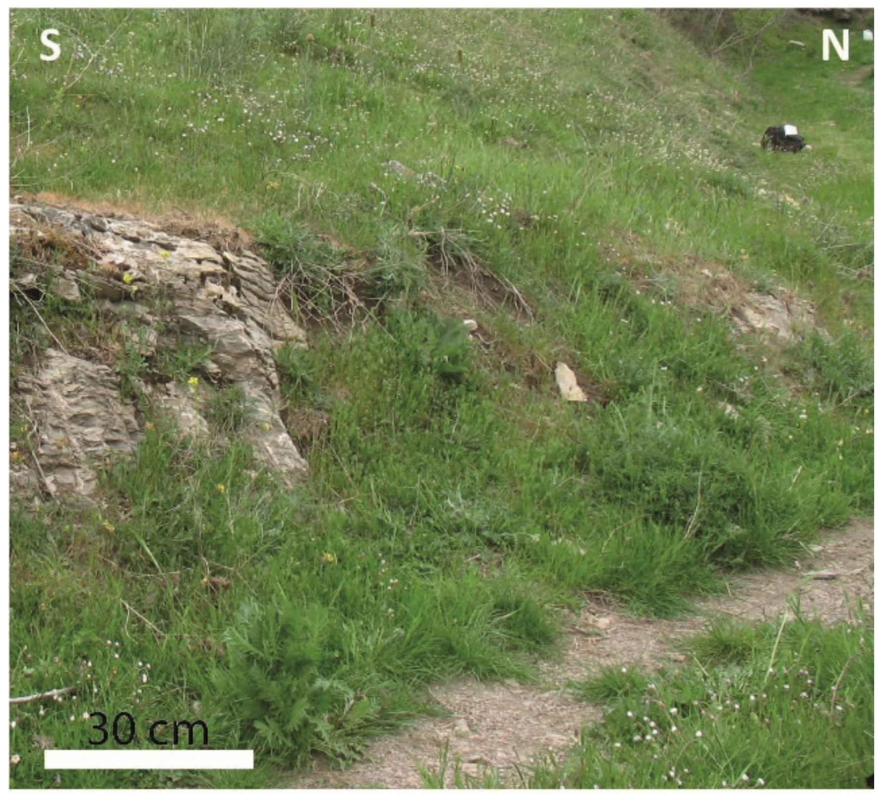
| Geological description The Rio Impisi outcrop shows the Alì-Montagnareale Unit’s youngest rocks. They are formed by varicolored metamarls alternating with radiolarites and grey cherty metalimestones (locally silicified). Limestones comprise crinoid- or oolite-rich packstone–grainstones and calcareous microbreccias with quartz lithoclasts. Striking slumps affect these rocks. Sedimentary structures and lithofacies suggest turbiditic sedimentation originated from a carbonate platform. Fossil associations with Vidalina (Early Jurassic?), belemnites and Aptychus (Tithonian), calpionellids (Tithonian-Berriasian?), and presumed Globotruncana (late Cretaceous?) are typical fauna of these deposits. Marls are characterized by microfauna assemblage made of Protoglobigerina spp. and abundant pelagic bivalves belonging to the genus Bositra (B. buchi?) (late Toarcian to the early Malm in age). Evidence of Globuligerina oxfordiana in grainstones intercalated in the metamarls testify to a Callovian–Oxfordian age [64,65,66,67,68,69]. | |
| Most remarkable geological features which justify the need to consider the occurrence as a geosite: Geological framework—Alpine syn-orogenic compression.The succession is strongly affected by boudin-like structures with pinch and swell structures. Boudin-like structures developed during compressive deformation phase D1 and are associated with the folds F1, being boudin’s long axis parallel to folds F1. These structures were coeval with a first Alpine metamorphic event D1 [64,65,66,67,68,69]. | |

| Name of the geosite | GS04—Alpine syn-orogenic compression and extension at Rio Impisi |
| Localization | Alì Terme (Messina, Sicily, Italy) |
| Geographical location | 38°0′54.53″ N–15°26′9.48″ E |
| Owner | Public |
| Legal protection | Non-existent |
| Fragility and vulnerability | Potential degrading area/anthropogenic activity |
| Accessibility | Site located less than 100 m from a paved road and with bus park site |
| Geosite category | Punctual |
| Geosite state | Under scientific study |
| Type of main scientific interest | Geological-Structural |
| Degree of scientific interest | International |
| Eventual limitations to its scientific use | Non-existent |
| Geological description The site exhibits the same stratigraphy illustrated for the previous GS03. | |
| Most remarkable geological features which justify the need to consider the occurrence as a geosite: Geological framework—Alpine syn-orogenic compression and extension.This site is punctual and covers only a ten of cm2 wide area of the cliff stretched along the national street. It shows a striking structure where the interference pattern between three deformation phases (D1, D2e, and D3) is observable. The bedding S0 is crosscut with an angle of 45° by a syn-metamorphic foliation S1. The contractional structures D1 are represented by sub-vertical foliation S1, associated with folds F1. A second sub-horizontal syn-metamorphic cleavage S2, locally associated with E–W trending folds F2 characterized by sub-horizontal axial planes, deforms foliation S1. Deformation D2e is due to syn-orogenic extension. Cleavage S2 (S1 and S0) is deformed and crosscut by a thrust with S-wards tectonic transport direction (D3) [64,65,66,67,68,69]. | |

| Name of the geodiversity site | GS05—Modderino klippe |
| Localization | Alì Terme (Messina, Sicily, Italy) |
| Geographical location | 38°1′7.43″ N–15°25′42.71″ E |
| Owner | Public |
| Legal protection | Non-existent |
| Accessibility | Site located less than 100 m from a paved road and with bus park site |
| Fragility and vulnerability | Potential degrading area/anthropogenic activity |
| Eventual links with ecological and cultural assets | Non-existent |
| Eventual use limitations | Non-existent |
| Safety conditions | Site with no safety facilities but with mobile phone coverage and located less than 50 km from emergency services |
| Observation conditions | Optimal |
| Geological description The Modderino klippe is an isolated outcrop of the Aspromonte Unit surrounded by the Alì-Montagnareale Unit. The klippe is formed of Variscan gneiss, whereas the Alì-Montagnareale Unit is made up of Mesozoic Verrucano beds [64,65,66,67,68,69]. | |
| Geodiversity features with potential educational use: Geological framework—Alpine syn-orogenic compression. The site offers the possibility to observe at the mesoscale a thrust with the chance to analyze the rocks of the hanging wall and the footwall at the same observation point. The thrust appears folded. The thrust tectonics is related to the early stages of the deformation phase D3 [64,65,66,67,68,69]. | |

| Name of the geodiversity site | GS06—Thrust of the Mandanici Unit at Puntale Serro |
| Localization | Alì (Messina, Sicily, Italy) |
| Geographical location | 38°1′1.84″ N–15°25′26.80″ E |
| Owner | Public |
| Legal protection | No-existent |
| Accessibility | Site located less than 100 m from a paved road and with bus park site |
| Fragility and vulnerability | Potential degrading area/anthropogenic activity |
| Eventual links with ecological and cultural assets | Non-existent |
| Eventual use limitations | Non-existent |
| Safety conditions | Site with no safety facilities but with mobile phone coverage and located less than 50 km from emergency services |
| Observation conditions | Optimal |
| Geological description The site shows the thrust of the Mandanici-Piraino Unit on the Alì-Montagnareale Unit. The hanging wall is made up of Variscan phyllites of the Mandanici-Piraino Unit. The footwall is made up of Mesozoic Verrucano beds of the Alì-Montagnareale Unit [64,65,66,67,68,69]. | |
| Geodiversity features with potential educational and/or touristic uses: Geological framework—Alpine syn-orogenic compression. This main thrust appears parallel to the minor thrusts affecting the Alì-Montagnareale Unit. The thrust dips NW-wards. A thick shear zone composed of phyllonites with C-S structures indicates a top-to-the-SE tectonic thrusting direction. The Alpine shear zone and thrust tectonics are related to deformation phase D3 [64,65,66,67,68,69]. | |

| Name of the geodiversity site | GS07—Marine terrace at Modderino |
| Localization | Modderino, Alì Terme (Messina, Sicily, Italy) |
| Geographical location of the outcrop | 38°0′51.55″ N–15°25′55.29″ E |
| Geographical location of the observation point (panoramic view) | 38°1′22.29″ N–15°25′26.23″ E (Belvedere of Alì) |
| Owner | Public |
| Legal protection | Non-existent |
| Accessibility | Site located less than 100 m from a paved road and with bus park site |
| Fragility and vulnerability | Potential degrading area |
| Eventual links with ecological and cultural assets | Non-existent |
| Eventual use limitations | Non-existent |
| Safety conditions | Site with no safety facilities but with mobile phone coverage and located less than 50 km from emergency services |
| Observation conditions | Optimal |
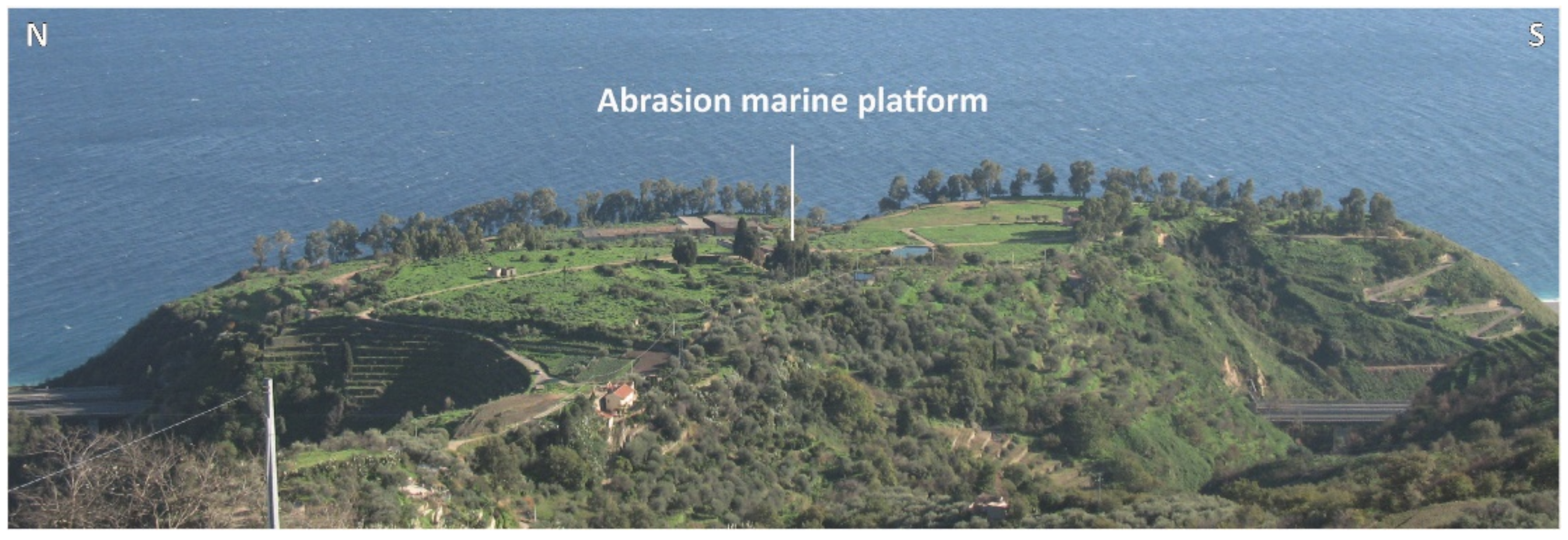
| Geological description A Pleistocene marine terrace may be observed at Modderino, looking from the panoramic view of Contrada Belvedere [77,78,79,80]. | |
| Geodiversity features with potential educational and/or touristic uses: Geological framework—Pleistocene marine terrace. The abrasion marine platform of the Modderino terrace shows an inner margin localized at an elevation of 140 m a.s.l. It was ascribed to the marine isotope substage MIS 5.5 and underwent an uplift characterized by a rate of 1.064 mm/ka [77,78,79,80]. | |

3.7. Inventory of the Geological Heritage in the Taormina Area

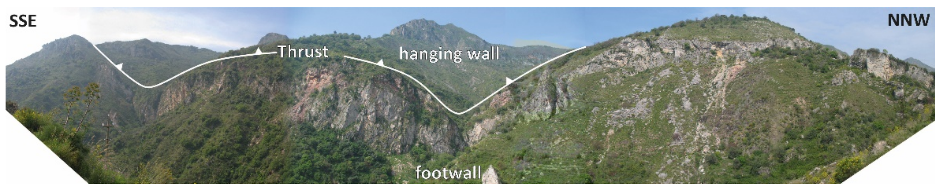
| Name of the geosite | GS08—Thrust at the Monte Veneretta–Monte Pernice ridge |
| Localization | Gallodoro (Messina, Sicily, Italy) |
| Geographical location of the outcrop | 37°52′27.29″ N–15°16′8.48″ E |
| Geographical location of the observation point (panoramic view) | 37°53′25.97″ N–15°17′7.78″ E |
| Owner | Public |
| Legal protection | Non-existent |
| Fragility and vulnerability | Potential degrading area |
| Accessibility | Site located less than 100 m from a paved road and with bus park site |
| Geosite category | Linear |
| Geosite state | Under scientific study |
| Type of main scientific interest | Structural, Stratigraphic, Paleontological |
| Degree of scientific interest | International |
| Eventual limitations to its scientific use | Non-existent |
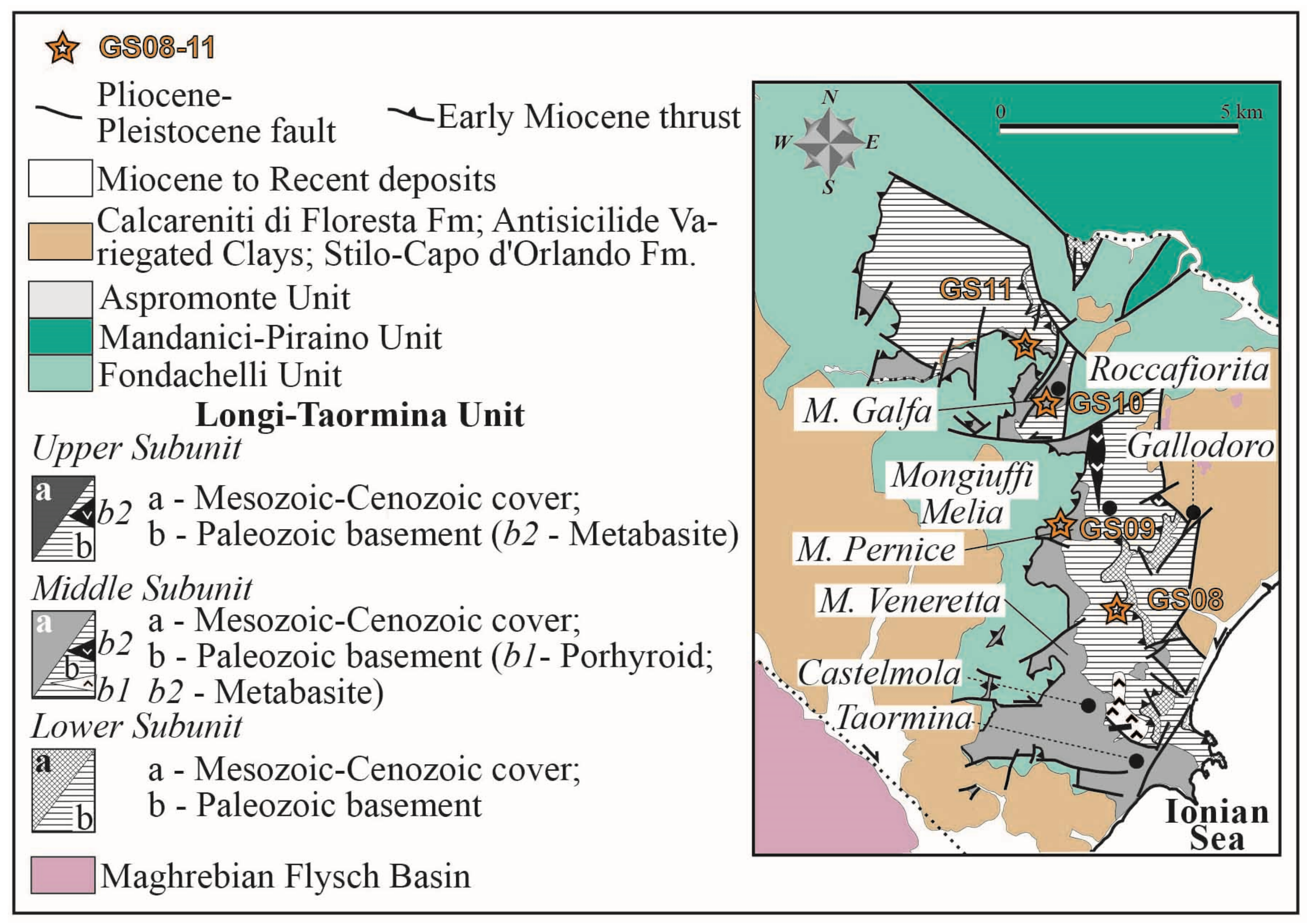
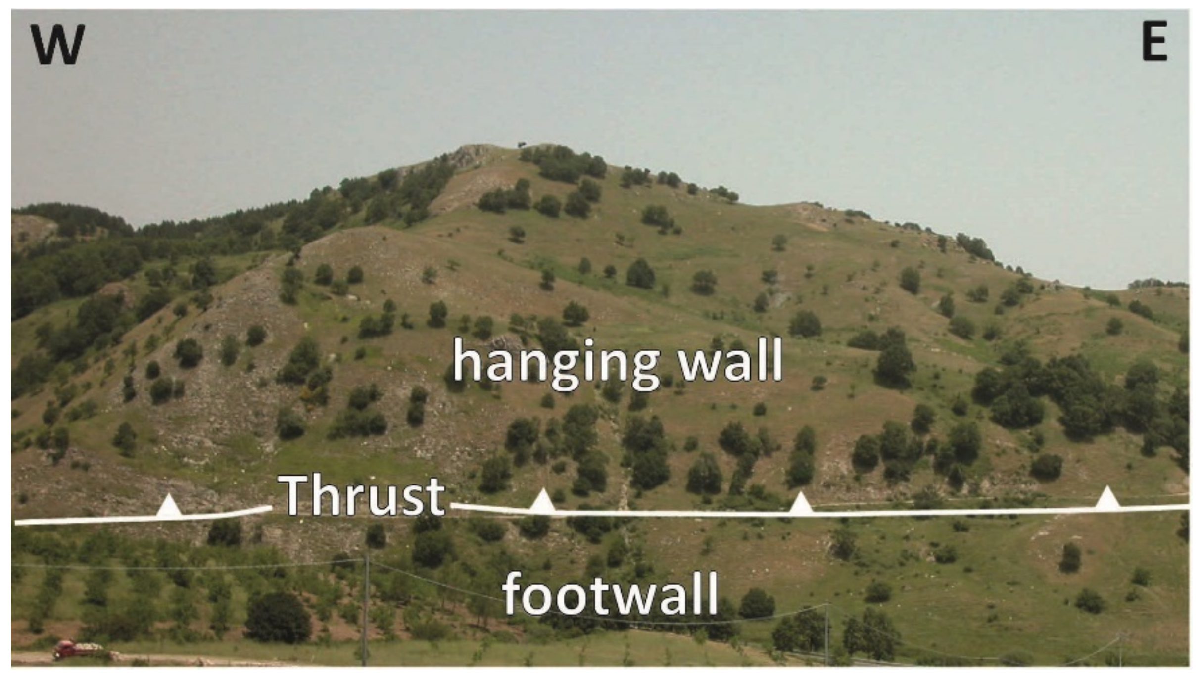
| Geological description Along the Monte Veneretta–Monte Pernice ridge, it is possible to observe the tectonic thrust stack of the Longi-Taormina Unit. Here it is composed of two minor tectonic units (upper and middle subunits). The Lower Subunit comprises Variscan metamorphic basement and Mesozoic–Cenozoic sedimentary cover (from base to top: continental redbeds, platform carbonates, condensed and basin succession). The Middle Subunit is composed of Variscan metamorphic basement and Mesozoic–Cenozoic sedimentary cover (from base to top: continental redbeds, platform carbonates, basinal marls, limestones, and radiolarites) [70]. | |
| Most remarkable geological features which justify the need to consider the occurrence as a geosite: Geological framework–Alpine thrust tectonics and Miocene block rotations along the arc-like structures. From this site, it is possible to appreciate a panoramic view of the structural setting of the Longi-Taormina Unit. The Monte Veneretta–Monte Pernice ridge represents a sector of the N–S domain of the “Z-shaped” pattern in plain view. Here, the morphostructural setting of the ridge is characterized by the N–S trend of the thrust sheets of the Longi-Taormina Unit. The structural trends, the strike directions of the thrusts, bedding, fold axes, stretched Jurassic ammonites, and the magnetic lineation (Kmax) analyzed in the Jurassic medolo limestones are N–S trending. Kinematic indicators (C-S structures) indicate a present-day top-to-the-west shear sense. The thrust of the Monte Veneretta–Monte Pernice ridge consists of an Aquitanian to early Burdigalian frontal ramp that underwent a Serravallian tectonic clockwise rotation. The N–S domain of the “Z-shaped” pattern underwent a W-wards tilting of at least 30–40° [65,69,71]. | |

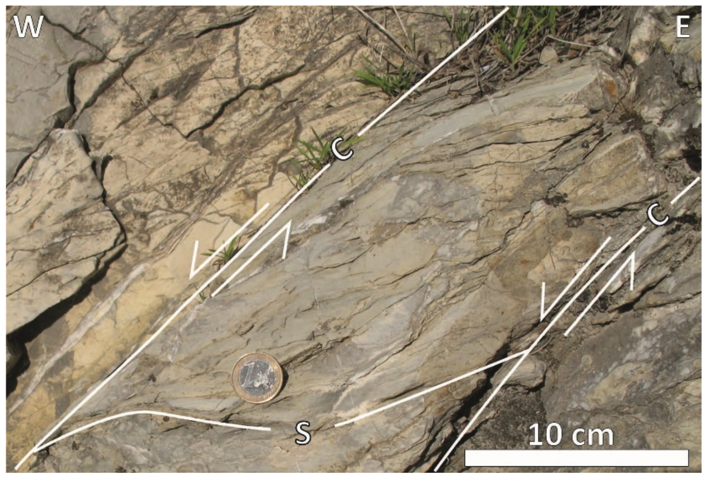
| Name of the geodiversity site | GS09—CS structures at Monte Pernice |
| Localization | Melia (Messina, Sicily, Italy) |
| Geographical location | 37°53′55.06″ N–15°15′49.05″ E |
| Owner | Public |
| Legal protection | Non-existent |
| Accessibility | Site located less than 100 m from a paved road and with bus park site |
| Fragility and vulnerability | Potential degrading area/anthropogenic activity |
| Eventual links with ecological and cultural assets | Non-existent |
| Eventual use limitations | Non-existent |
| Safety conditions | Site with no safety facilities but with mobile phone coverage and located less than 50 km from emergency services |
| Observation conditions | Optimal |
| Geological description The Monte Pernice area represents the northern termination of the N–S domain of the “Z-shaped” pattern in plain view, where the thrusts of the Fondachelli and Longi-Taormina Units are involved [70]. | |
| Geodiversity features with potential educational and/or touristic uses: Geological framework—Alpine thrust tectonics and Miocene block rotations along the arc-like structures. CS-type shear bands may be observed in the Medolo limestones. C-planes mainly developed parallel to the bedding S0 whereas S-planes with sigmoidal patterns arranged with angles lower than 45° with respect to C-planes. C- and S-planes are W-wards dipping. Calcite steps present on the C-planes and the C-S patterns indicate a general top-to-the-west shear sense. The C/S fabrics are here interpreted as kinematic indicators of the tectonic transport direction associated with the thrust tectonics affecting this area of the Peloritani Mts. The magnetic lineation (Kmax) is coherent with other structural data. The N–S trend of the thrust depends on a Serravallian tectonic clockwise rotation. Additionally, in this area, the thrust shows a W-wards tilting of at least 30–40° [70,71]. | |

| Name of the geosite | GS10—Fold at Monte Galfa |
| Localization | Roccafiorita (Messina, Sicily, Italy) |
| Geographical location of the outcrop | 37°55′28.36″ N—15°15′48.41″ E |
| Geographical location of the observation point (panoramic view) | 37°54′47.18″ N—15°16′35.80″ E |
| Owner | Public |
| Legal protection | Non-existent |
| Fragility and vulnerability | Potential degrading area |
| Accessibility | Site located less than 100 m from a paved road and with bus park site |
| Geosite category | Areal |
| Geosite state | Under scientific study |
| Type of main scientific interest | Structural and Stratigraphic |
| Degree of scientific interest | International |
| Eventual limitations to its scientific use | Non-existent |
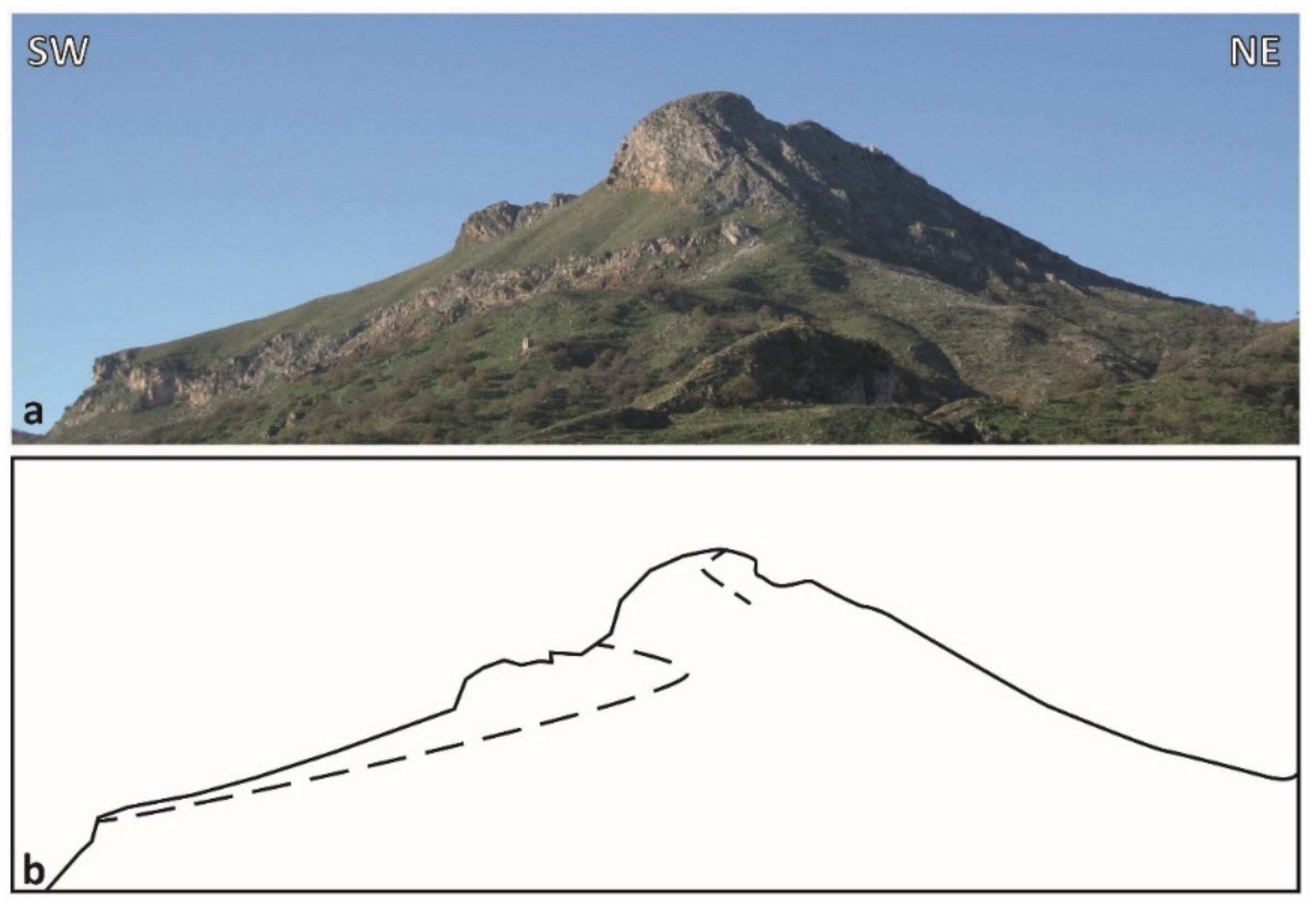
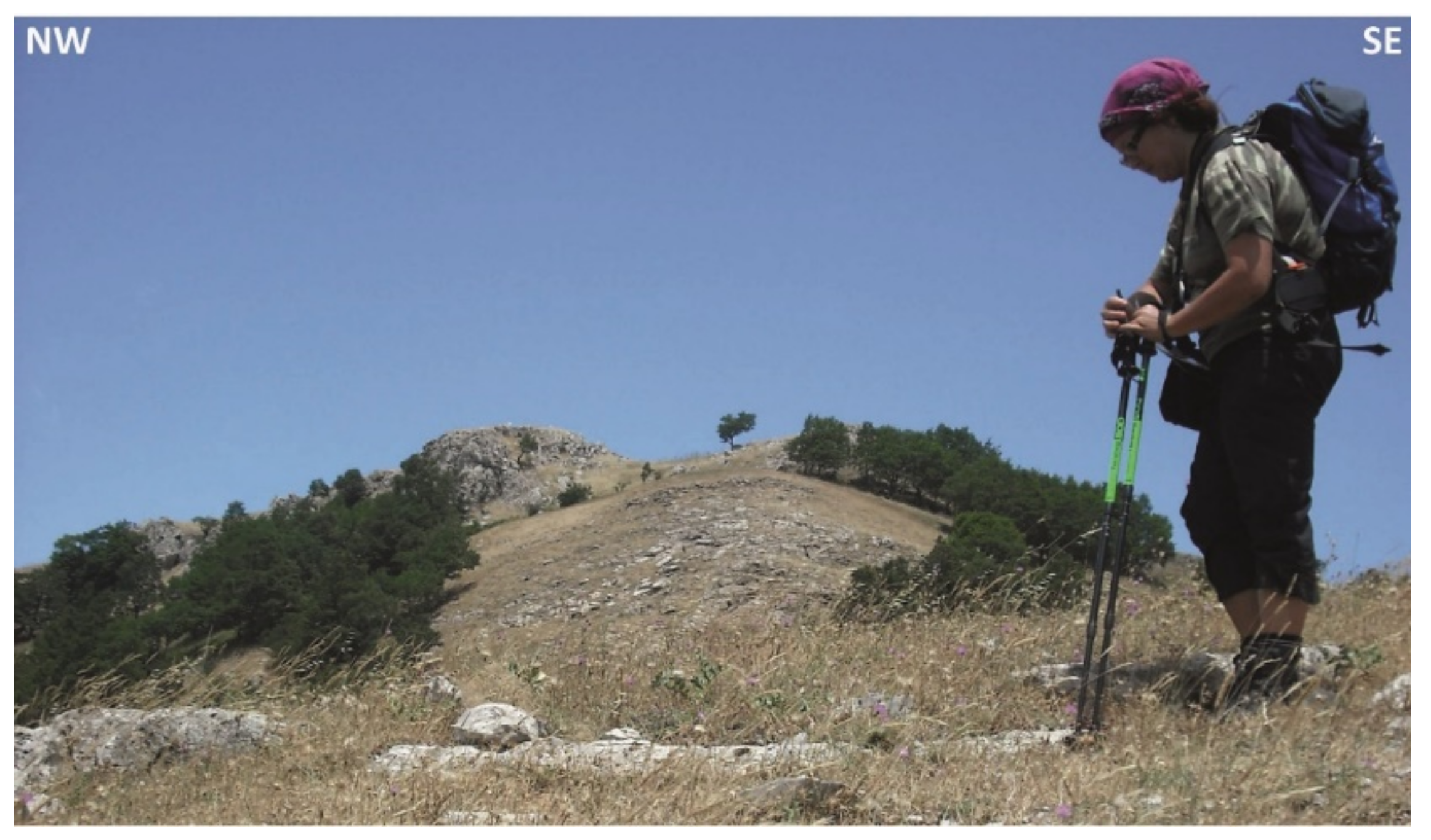
| Geological description The Monte Galfa (or Monte Kalfa, 1000 m a.s.l.) area exhibits the Paleozoic to the Mesozoic stratigraphic record of the Longi-Taormina Unit. The Mesozoic cover is here composed, from bottom to top, of redbeds, dolostones, oolitic limestones, and Medolo-type marly limestones [70,71]. The cover is affected by a macroscale fold. | |
| Most remarkable geological features which justify the need to consider the occurrence as a geosite: Geological framework—Alpine thrust tectonics and Miocene block rotations along the arc-like structures. A panoramic view of Monte Galfa allows to observe a fold affecting the Longi-Taormina Unit rocks. The fold at Monte Galfa is localized in the joint area between the northernmost edge of the N–S trending thrusts and the WNW-ESE trending thrusts of the “Z-shaped” morphostructural pattern. The fold presents a W-dipping axial surface with a normal limb dipping W-wards of 30° and a reversed limb dipping NE-wards of 45°. This fold should be associated with thrust tectonics affecting the unit. In present-day coordinates, this fold is an E-verging antiform compatible with the general west-ward anticlockwise tilting of more than 30° observed in the area [70,71]. | |

| Name of the geosite | GS11—Thrust of the Fondachelli Unit at Monte Galfa |
| Localization | Roccafiorita (Messina, Sicily, Italy) |
| Geographical location | 37°56′1.29″ N–15°15′24.12″ E |
| Owner | Public |
| Legal protection | Non-existent |
| Fragility and vulnerability | Potential degrading area/anthropogenic activity |
| Accessibility | Site located less than 100 m from a paved road and with bus park site |
| Geosite category | Linear |
| Geosite state | Under scientific study |
| Type of main scientific interest | Structural |
| Degree of scientific interest | International |
| Eventual limitations to its scientific use | Non-existent |
| Geological description This site is localized on the north-western slope of Monte Galfa, where it is possible to observe the Aquitanian to early Burdigalian thrust of the Fondachelli Unit on the Longi-Taormina Unit. Variscan phyllites of the Fondachelli Unit form the hanging wall, whereas the footwall is made up of Jurassic dolostones of the Longi-Taormina Unit. The morphostructural transition from the Longi-Taormina Unit to the Fondachelli Unit is visible along the cliff in the dolostones and the moderately dipping slope in the Variscan basement [70,71]. | |
| Most remarkable geological features which justify the need to consider the occurrence as a geosite: Alpine thrust tectonics and Miocene block rotations along arc-like structures. The thrust appears WNW–ESE trending and tilted SSW-wards. Kinematic indicators (CS-structures) associated with the thrust of the Fondachelli Unit on the Longi-Taormina Unit show a top-to-the-SSW shear sense. Magnetic lineation (Kmax) in the Medolo limestones of the Longi-Taormina Unit is WNW-ESE trending. The WNW–ESE structural trend in this area of the “Z-shaped” morphostructural pattern is related to a Serravallian tectonic clockwise rotation [70,71]. | |

3.8. Inventory of the Geological Heritage in the Roccella Valdemone Area

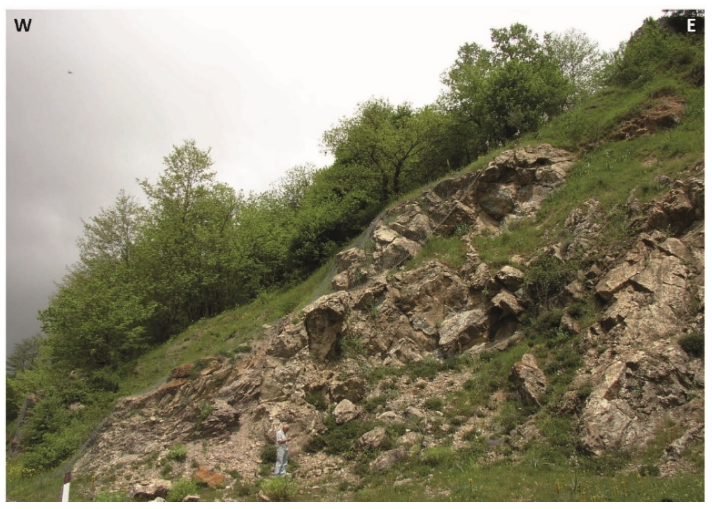
| Name of the geosite | GS12—Peloritani Thrust Front in the central sector of the Taormina Line |
| Localization | Santa Domenica Vittoria (Messina, Sicily, Italy) |
| Geographical location | 37°57′5.19″ N–14°57′27.15″ E |
| Owner | Public |
| Legal protection | Non-existent |
| Fragility and vulnerability | Potential degrading area |
| Accessibility | Site located less than 100 m from a paved road and with bus park site |
| Geosite category | Areal |
| Geosite state | Under scientific study |
| Type of main scientific interest | Stratigraphic, structural, geomorphological |
| Degree of scientific interest | International |
| Eventual limitations to its scientific use | Non-existent |
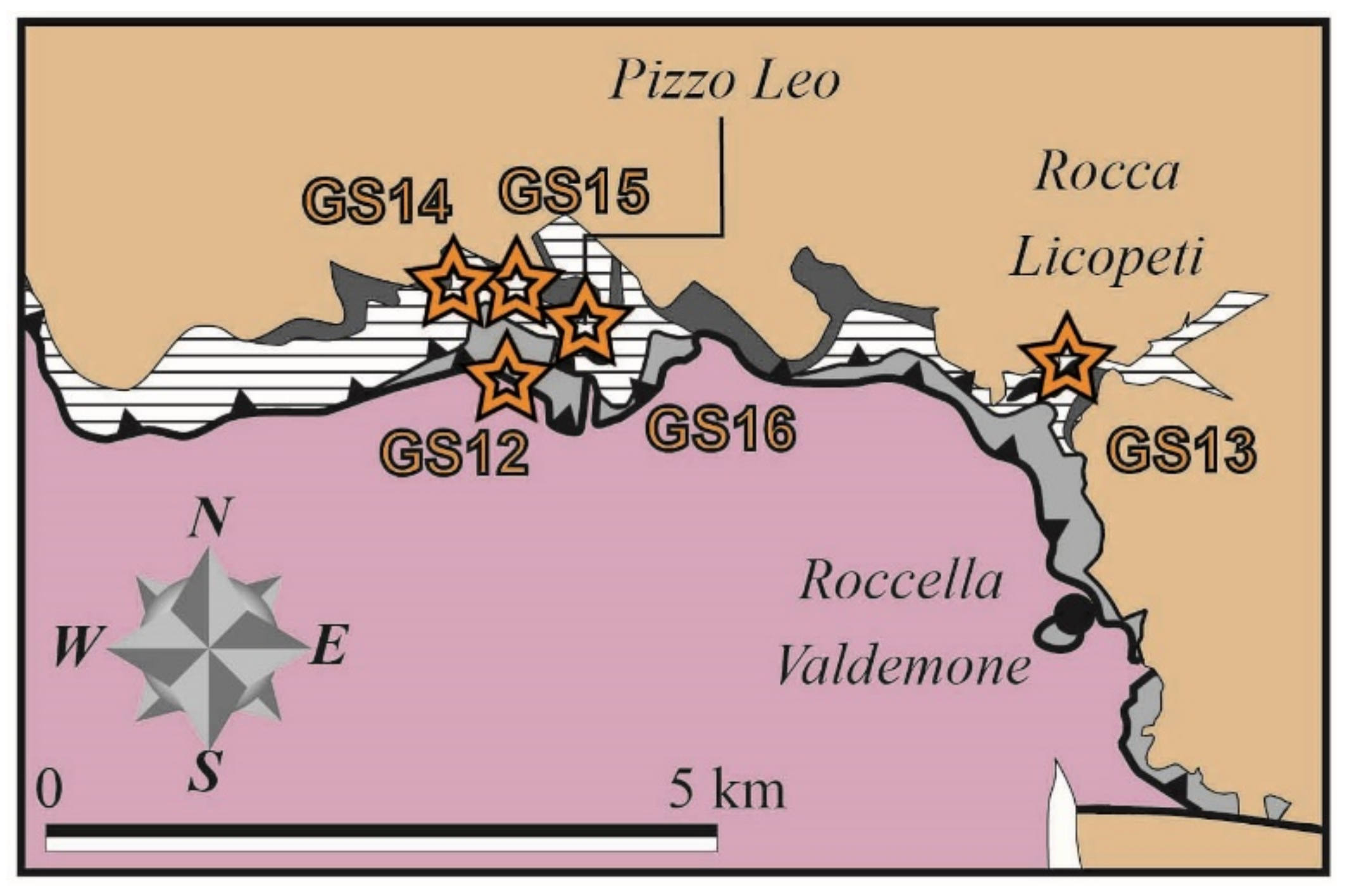
| Geological description The Peloritani Thrust Front (or Taormina Line; Figure 3) represents the Miocene tectonic margin of the Calabria–Peloritani Arc in Sicily. Along this tectonic boundary, the Longi-Taormina Unit of the Alpine Chain overthrusts the more external units of the Maghrebian Flysch Basin [58,59,60,61,62,70,71]. | |
| Most remarkable geological features which justify the need to consider the occurrence as a geosite: Geological framework—Alpine thrust tectonics. At the site, it is possible to observe the upper Burdigalian overthrust of the Jurassic limestones of the Longi-Taormina Unit on the lower Cretaceous flysch deposits of the Monte Soro Unit [65,69,70,71]. | |

| Name of the geosite | GS13—Paleozoic pillow lavas at Rocca Licopeti |
| Localization | Roccella Valdemone (Messina, Sicily, Italy) |
| Geographical location | 37°56′53.35″ N–15° 0′32.45″ E |
| Owner | Public |
| Legal protection | Non-existent |
| Fragility and vulnerability | Potential degrading area |
| Accessibility | Site located less than 100 m from a paved road and with bus park site |
| Geosite category | Linear |
| Geosite state | Under scientific study |
| Type of main scientific interest | Volcanic, Petrographic, Mineralogical |
| Degree of scientific interest | International |
| Eventual limitations to its scientific use | Non-existent |
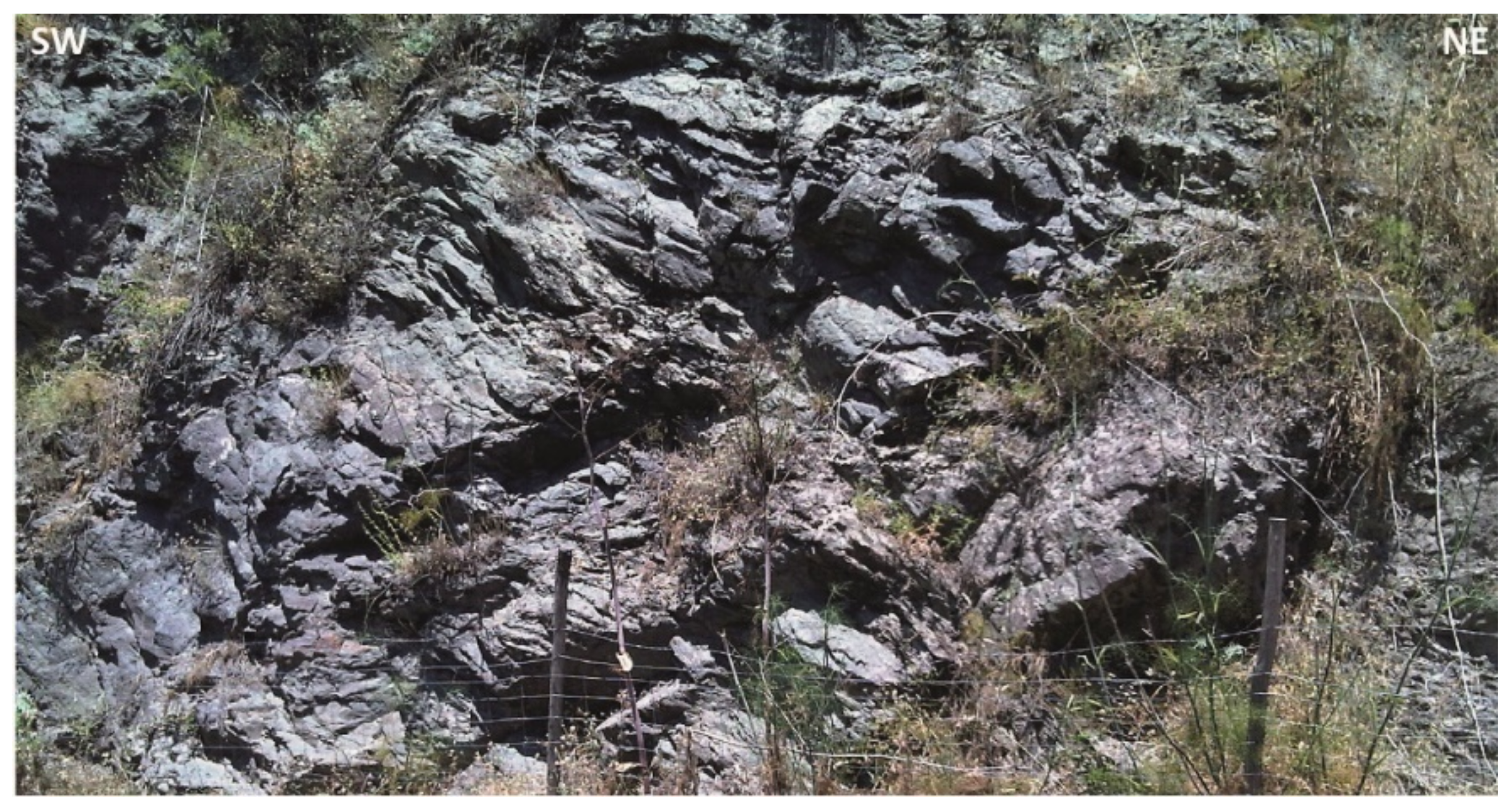
| Geological description At Rocca Licopeti, the Paleozoic succession of the Longi-Taormina Unit is composed of metapelites and metarenites, showing layers of metavolcanites with alkaline affinity. These layers belong to the Silurian Lower Pizzo Leo Formation [73,75]. | |
| Most remarkable geological features which justify the need to consider the occurrence as a geosite: Geological framework—Paleozoic stratigraphy. These alkaline metavolcanites are composed of dark-green volcanic metabreccias, metatuffs, and metabasalts. The latter show pillow structures with degassing vacuoles, indicating an origin from submarine eruptions [73,75]. | |

| Name of the geosite | GS14—Silurian to Devonian conodonts in the Favoscuro west section |
| Localization | Floresta (Messina, Sicily, Italy) |
| Geographical location | 37°57′24.92″ N–14°57′13.27″ E |
| Owner | Public |
| Legal protection | Existent, being localized in the Nebrodi Park. |
| Fragility and vulnerability | Potential degrading area |
| Accessibility | Site located less than 100 m from a paved road and with bus park site |
| Geosite category | Linear |
| Geosite state | Under scientific study |
| Type of main scientific interest | Stratigraphic, paleontological, structural |
| Degree of scientific interest | International |
| Eventual limitations to its scientific use | Non-existent |
| Geological description A stratigraphic section was realized in the Paleozoic succession exposed along the west side of the Favoscuto stream [74]. In the northern part of this section, the lithostratigraphy is characterized, from base to top, by i) a basal lens of nodular metalimestones; ii) metamarls with minor varicolored metapelites and calc-schists with intercalation of calc-schists; iii) calc-schists. In the southern part of the section, the succession is formed by metalimestones with intercalation of metamarls [73,74,75]. These layers were ascribed to the Silurian Lower Pizzo Leo and the Devonian Upper Pizzo Leo Formations. | |
| Most remarkable geological features which justify the need to consider the occurrence as a geosite: Geological framework—Paleozoic stratigraphy and guide fossils. The calcareous beds sampled in the northern part of the section yielded conodont associations indicating an age ranging from the Ludlow (Ancoradella ploeckensis–Polygnathoides siluricus Zones) of the late Silurian to the earliest Emsian (Polygnathus kitabicus–Polygnathus excavatus Zones) of the Devonian [74]. The calcareous beds sampled in the southern part of the section yielded conodont associations indicating an age referable to the Emsian (Polygnathus excavatus Zone to the nothoperbonus–inversus Zones) of the Devonian [73,74,75]. | |

| Name of the geosite | GS15—Devonian conodonts in the Favoscuro east section |
| Localization | Santa Domenica Vittoria (Messina, Sicily, Italy) |
| Geographical location | 37°57′20.27″ N/14°57′19.22″ E |
| Owner | Public |
| Legal protection | Non-existent |
| Fragility and vulnerability | Potential degrading area/anthropogenic activity |
| Accessibility | Site located less than 100 m from a paved road and with bus park site |
| Geosite category | Linear |
| Geosite state | Under scientific study |
| Type of main scientific interest | Stratigraphic, paleontological, structural |
| Degree of scientific interest | International |
| Eventual limitations to its scientific use | Non-existent |
| Geological description The Favoscuro East Section consists, from base to top, of a Paleozoic succession made up of: metapelites, strongly deformed metalimestones, platy succession of metapelites and calc-schists, massive iron-rich metalimestone, bedded metalimestones, platy succession of calc-schists and metamarls with platy metalimestone and metapelite intercalations. These layers belong to the Devonian Upper Pizzo Leo Formation [73,74,75]. | |
| Most remarkable geological features which justify the need to consider the occurrence as a geosite: Geological framework—Paleozoic stratigraphy and guide fossils. The taxa found in these Paleozoic beds are represented by mm-sized dacryoconarids and conodont associations, referred to the early Emsian age (nothoperbonus Zone) of the Devonian [73,74,75]. | |

| Name of the geosite | GS16—Devonian conodonts in the Pizzo Leo section |
| Localization | Santa Domenica Vittoria (Messina, Sicily, Italy) |
| Geographical location | 37°57′13.71″ N–14°57′38.03″ E |
| Owner | Public |
| Legal protection | Non-existent |
| Fragility and vulnerability | Potential degrading area |
| Accessibility | Site located less than 100 m from a paved road and with bus park site |
| Geosite category | Areal |
| Geosite state | Under scientific study |
| Type of main scientific interest | Stratigraphic, paleontological, structural |
| Degree of scientific interest | International |
| Eventual limitations to its scientific use | Non-existent |
| Geological description The Pizzo Leo stratigraphic succession is made eliminate of, from base to top, of (i) metapelites with lenses of dark green metabasalts and metadolerites of alkaline affinity, with rare intercalations of carbonate lenses and calc-schists in the metapelites overlying the metavolcanites, (ii) metacarbonates, (iii) strongly deformed and recrystallized limestones, evolving upwards to bedded and platy limestones, (iv) metamarls with minor varicolored calc-schists and metapelites [73,74,75]. These layers belong to the Silurian to Devonian Upper Pizzo Leo Formation. | |
| Most remarkable geological features which justify the need to consider the occurrence as a geosite: Geological framework—Paleozoic stratigraphy and guide fossils. The platy limestones of the studied Paleozoic succession yielded conodonts assigned to the Lochkovian (delta Zone) of the Devonian [73,74,75]. | |

4. Discussion and Conclusions
- i.
- The sites GS01–GS05, notwithstanding their high potential for educational use, cannot be used for educational purposes due to their elevated degradation risk.
- ii.
- The sites GS02–GS03, notwithstanding their high potential for touristic use, cannot be used for geotourism due to their elevated degradation risk.
- iii.
- The geosites GS12–GS16, notwithstanding their high potential for educational use but considering their moderate degradation risk, cannot be used for education.
- iv.
- The sites GS06 and GS12–GS16, considered to be of moderate potential touristic use, are not significant for geotourism.
- v.
- All the identified geosites should be officially inventoried by the authority ARTA.
- vi.
- The geosites GS01/GS03–GS04/GS12–GS16, considered a high degradation risk, should be subjected to their management with priority.
- vii.
- The management of geosites GS08/GS10–GS11, due to their low degradation risk, should require less urgent intervention to preserve their geodiversity.
- viii.
- The geodiversity sites GS07/GS09 and the geosites GS08/GS10–GS11, being provided with potential educational use and low degradation risk, can be used for educational purposes in their present conditions.
- ix.
- The site GS06, considered its high potential for educational use and the moderate degradation risk, and being a geodiversity site, could be used for educational purposes.
| ID | Geoheritage | Scientific Value of a Geosite (Score: 1–2–4) | Potential Educational Use (Score: 1–4) | Potential Touristic Use (Score: 1–4) | Degradation Risk (Score: 1–4) |
|---|---|---|---|---|---|
| GS01 | Geosite | 3.45 | 3.2 | 2.35 | 3.75 |
| GS02 | Geodiversity site | 2.5 | 3.6 | 3.05 | 3.05 |
| GS03 | Geosite | 3.4 | 3.6 | 3.05 | 3.75 |
| GS04 | Geosite | 3.45 | 3.2 | 2.35 | 3.75 |
| GS05 | Geodiversity site | 2.6 | 3.5 | 2.65 | 3.05 |
| GS06 | Geodiversity site | 2.6 | 3.3 | 2.85 | 2.5 |
| GS07 | Geodiversity site | 2.4 | 3.2 | 2.75 | 1.6 |
| GS08 | Geosite | 3.4 | 3.5 | 2.95 | 1.9 |
| GS09 | Geodiversity site | 2.2 | 3.25 | 2.45 | 1.75 |
| GS10 | Geosite | 3.6 | 3.5 | 2.95 | 2.0 |
| GS11 | Geosite | 3.4 | 3.3 | 2.8 | 1.85 |
| GS12 | Geosite | 3.0 | 3.3 | 2.75 | 2.85 |
| GS13 | Geosite | 3.0 | 3.2 | 2.75 | 2.85 |
| GS14 | Geosite | 3.5 | 3.2 | 2.45 | 2.45 |
| GS15 | Geosite | 3.2 | 3.2 | 2.45 | 2.85 |
| GS16 | Geosite | 3.2 | 3.3 | 2.55 | 2.1 |
- i.
- Identify potential geosites of high international scientific value related to different geological frameworks, urgently subject to official inventory by ARTA and geoconservation.
- ii.
- Exclude several geosites by any possible education and touristic initiatives if no future endeavors are realized in order to lower the degradation risk.
- iii.
- Promote initiatives as geo routes involving sites with proper degradation risk for geoknowledge transfer and geo-education purposes.
Funding
Institutional Review Board Statement
Informed Consent Statement
Data Availability Statement
Acknowledgments
Conflicts of Interest
References
- A Methodology for the Identification of Significant Landforms and Geological Sites for Geoconservation Purposes. Available online: https://eprints.utas.edu.au/11747/ (accessed on 15 May 2022).
- Dixon, G. Geoconservation: An International Review and Strategy for Tasmania; Parks and Wildlife Service: Tasmania, Australia, 1996; pp. 1–101.
- Wimbleton, W.A.P.; Gerasimenko, N.; Alexandrowicz, Z.; Vinokurov, V.; Liscak, P.; Vozar, A.; Vozarova, A.; Bezak, V.; Kohut, M.; Polak, M.; et al. A first attempt at a geosites framework for Europe—An IUGS initiative to support recognition of world heritage and European geodiversity. Geol. Balc. 1998, 28, 5–32. [Google Scholar]
- Prosser, C.D. Our rich and varied geoconservation portfolio: The foundation for the future. Proc. Geol. Assoc. 2013, 124, 568–580. [Google Scholar] [CrossRef]
- Black, G.P.; Gonggrijp, G.P. Fundamental thoughts on Earth-science conservation. Jb. Geol. B.-A. 1990, 133, 655–657. [Google Scholar]
- Wimbledon, W.A.P. GEOSITES—An International Union of Geological Sciences initiative to conserve our geological heritage. Pol. Geol. Inst. Spec. Pap. 1999, 2, 5–8. [Google Scholar]
- Reuss, R.L.; Gardulski, A.F. An interactive game approach to learning in historical geology and paleontology. J. Geosci. Educ. 2001, 49, 120–129. [Google Scholar] [CrossRef]
- Brilha, J.B. Geoconservation and protected areas. Environ. Conserv. J. 2002, 29, 273–276. [Google Scholar] [CrossRef]
- Santangelo, N.; Santo, A.; Guida, D.; Lanzara, R.; Siervo, V. The geosites of the Cilento-Vallo di Diano national park (Campania region, southern Italy). Il Quat. Ital. J. Quat. Sci. 2005, 18, 103–114. [Google Scholar]
- Erikstad, L. History of geoconservation in Europe. In The History of Geoconservation; Burek, C.V., Prosser, C.D., Eds.; Geological Society, Special Publications: London, UK, 2008; pp. 249–256. [Google Scholar]
- Gray, J.M. Geodiversity: Developing the paradigma. Proc. Geol. Assoc. 2008, 119, 287–298. [Google Scholar] [CrossRef]
- Gray, J.M. Geodiversity: Valuing and Conserving Abiotic Nature, 2nd ed.; Wiley-Blackwell: Chichester, UK, 2013; p. 512. ISBN 978-0-470-74215-0. [Google Scholar]
- Joyce, E.B. Australia’s Geoheritage: History of Study, A New Inventory of Geosites and Applications to Geotourism and Geoparks. Geoheritage 2010, 2, 39–56. [Google Scholar] [CrossRef]
- Lima, F.F.; Brilha, J.B.; Salamuni, E. Inventorying geological heritage in large territories: A methodological proposal applied to Brazil. Geoheritage 2010, 2, 91–99. [Google Scholar] [CrossRef]
- McKeever, P.; Zouros, N.; Patzak, M.; Weber, J. The UNESCO global network of national geoparks. In Geotourism: The Tourism of Geology and Landscape; Newsome, D., Dowling, R., Eds.; Goodfellow Publishers Ltd.: Oxford, UK, 2010; pp. 221–230. [Google Scholar]
- Prosser, C.D.; Burek, C.V.; Evans, D.H.; Gordon, J.E.; Kirkbride, V.B.; Rennie, A.F.; Walmsley, C.A. Conserving geodiversity sites in a changing climate: Management challenges and responses. Geoheritage 2010, 2, 123–136. [Google Scholar] [CrossRef]
- Ruban, D.A. Quantification of geodiversity and its loss. Proc. Geol. Assoc. 2010, 121, 326–333. [Google Scholar] [CrossRef]
- Henriques, M.H.; Pena dos Reis, R.; Brilha, J.; Mota, T.S. Geoconservation as an emerging geoscience. Geoheritage 2011, 3, 117–128. [Google Scholar] [CrossRef]
- Fermeli, G.; Meléndez, G.; Calonge, A.; Dermitzakis, M.; Steininger, F.; Koutsouveli, A.; Neto de Carvalho, C.; Rodrigues, J.; D’Arpa, C.; Di Patti, C. Geoschools: Innovative teaching of geosciences in secondary schools and raising awareness on geoheritage in the society. In Avances y Retos en la conservación del Patrimonio Geológico en España; Fernández-Martínez, E., Castaño de Luis, R., Eds.; Actas de la IX Reunión Nacional de la Comisión de Patrimonio Geológico (SGE): León, Spain, 2011; pp. 120–124. [Google Scholar]
- Browne, M.A.E. Geodiversity and the role of the planning system in Scotland. Scott. Geogr. J. 2012, 128, 266–277. [Google Scholar] [CrossRef]
- Fassoulas, C.; Mouriki, D.; Dimitriou-Nikolakis, P.; Iliopoulos, G. Quantitative assessment of geotopes as an effective tool for geoheritage management. Geoheritage 2012, 4, 177–193. [Google Scholar] [CrossRef]
- Bollati, I.; Smiraglia, C.; Pelfini, M. Assessment and selection of geomorphosites and trails in the Miage Glacier Area (Western Italian Alps). Environ. Manag. 2013, 51, 951–967. [Google Scholar] [CrossRef]
- Magagna, A.; Ferrero, E.; Giardino, M.; Lozar, F.; Perotti, L. A selection of geological tours for promoting the Italian geological heritage in the secondary schools. Geoheritage 2013, 5, 265–273. [Google Scholar] [CrossRef]
- Pereira, D.I.; Pereira, P.; Brilha, J.; Santos, L. Geodiversity assessment of Paraná State (Brazil): An innovative approach. Environ. Manag. 2013, 52, 541–552. [Google Scholar] [CrossRef]
- Clary, R.M.; Wandersee, J.H. Lessons from US fossil parks for effective informal science education. Geoheritage 2014, 6, 241–256. [Google Scholar] [CrossRef]
- Fuertes-Gutiérrez, I.; Pérez Arlucea, M.; González-Villanueva, R.; Arias Ferrero, F.; Hernández-Paredes, R.; De Miguel Ximénez, C.J.; Escorihuela, J.; Cuevas-González, J.; García-Aguilar, J.M. El valor didáctico del patrimonio geológico y el valor patrimonial de los recursos didácticos. Ensen. Cienc. 2014, 22, 69–80. [Google Scholar]
- Reis, J.; Póvoas, L.; Barriga, F.J.A.S.; Lopes, C.; Santos, V.F.; Ribeiro, B.; Cascalho, J.; Pinto, A. Science education in a museum: Enhancing earth sciences literacy as a way to enhance public awareness of geological heritage. Geoheritage 2014, 6, 217–223. [Google Scholar] [CrossRef]
- Rodríguez-Pérez, E.; Romero-Nieto, D.; Fesharaki, O. Gymkhana geourbana como método didáctico y de motivación de estudiantes de geología. Reduca 2014, 6, 1–25. [Google Scholar]
- Santangelo, N.; Romano, P.; Santo, A. Geo-itineraries in the Cilento Vallo di Diano Geopark: A Tool for Tourism Development in Southern Italy. Geoheritage 2014, 7, 319–335. [Google Scholar] [CrossRef]
- Vidal-Meló, A.V.; Sala, B.R.; Fuster, V.D.E.; Planes, F.J.B. A gymkhana to discover and generate curves in a cooperative work. Multidiscip. J. Educ. Soc. Technol. Sci. 2014, 1, 53–68. [Google Scholar] [CrossRef][Green Version]
- Bursztyn, N.; Pederson, J.; Shelton, B.; Walker, A.; Campbell, T. Utilizing geo-referenced mobile game technology for universally accessible virtual geology field trips. Int. J. Educ. Math. Sci. Technol. 2015, 3, 93–100. [Google Scholar] [CrossRef]
- Fermeli, G.; Meléndez, G.; Koutsouveli, A.; Dermitzakis, M.; Calonge, A.; Steininger, F.; D’Arpa, C.; Di Patti, C. Geoscience teaching and student interest in secondary schools-preliminary results from an interest research in Greece, Spain and Italy. Geoheritage 2015, 7, 13–24. [Google Scholar] [CrossRef]
- Lagally, U.; Loth, R.; Schindelmann, C. The “day of Geosites” in Germany—A successful promotion tool for earth sciences. Geoheritage 2015, 7, 195–204. [Google Scholar] [CrossRef]
- Sanchez, E.; Kalmpourtzis, G.; Cazes, J.; Berthoix, M.; Monod-Ansaldi, R. Learning with Tactileo Map: From Gamification to Ludicization of Fieldwork. GI Forum J. Geo. Minds Soc. 2015, 1, 261–271. [Google Scholar] [CrossRef]
- Wang, L.; Tian, M.; Wang, L. Geodiversity, geoconservation and geotourism in Hong Kong Global Geopark of China. Proc. Geol. Assoc. 2015, 126, 426–437. [Google Scholar] [CrossRef]
- Al-Azawi, R.; Al-Faliti, F.; Al-Blushi, M. Educational Gamification vs game based learning: Comparative study. Int. J. Innov. Manag. Technol. 2016, 7, 132–136. [Google Scholar] [CrossRef]
- Brilha, J.B. Inventory and Quantitative Assessment of Geosites and Geodiversity Sites: A Review. Geoheritage 2016, 8, 119–134. [Google Scholar] [CrossRef]
- Chen, C.L.D.; Yeh, T.K.; Chang, C.Y. The effects of game-based learning and anticipation of a test on the learning outcomes of 10th grade geology students. Eurasia J. Math. Sci. Technol. Educ. 2016, 12, 1379–1388. [Google Scholar] [CrossRef]
- Crespo-Blanc, A.; Alfaro, P.; Alonso-Zarza, A.; Aurell, M.; Calonge, A.; Carcavilla, L.; Corral, I. Geolodía para un público numeroso: Claves para su organización. Geogaceta 2016, 59, 91–94. [Google Scholar]
- Santangelo, N.; Bravi, S.; Santo, A. Itinerario 12 Piana del Sele, Monti Alburni e Vallo di Diano. In Guide Geologiche Regionali-Campania e Molise; Calcaterra, D., D’Argenio, B., Ferranti, L., Pappone, G., Petrosino, P., Eds.; Società Geologica Italiana: Rome, Italy, 2016; pp. 227–242. [Google Scholar]
- Karagiorgas, D.N.; Niemann, S. Gamification and game-based learning. J. Educ. Technol. Syst. 2017, 45, 499–519. [Google Scholar] [CrossRef]
- Kelley, D.; Salazar, R. Geosites in the Galápagos Islands used for geology education programs. Geoheritage 2017, 9, 351–358. [Google Scholar] [CrossRef]
- Torabi Farsani, N.; Mortazavi, M.; Bahrami, A.; Kalantary, R.; Khosravi Bizhaem, F. Traditional crafts: A tool for geo-education in geotourism. Geoheritage 2017, 9, 577–584. [Google Scholar] [CrossRef]
- Barasoain, D.; Azanza, B. Geoheritage and education: A practical example from the Rhinoceros of Toril 3 (Calatayud-Daroca Basin, Spain). Geoheritage 2018, 10, 363–374. [Google Scholar] [CrossRef]
- Berrocal-Casero, M.; Arribas, M.; Moratalla, J.J. Didactic and divulgative resources of the middle Triassic vertebrate tracksite of Los Arroturos (province of Guadalajara, Spain). Geoheritage 2018, 10, 375–384. [Google Scholar] [CrossRef]
- Martín Abad, H.; Blanco Moreno, C.; Barrios de Pedro, S.; Marugán-Lobón, J.; Poyato Ariza, F.J.; Delvene, G.; Moratalla, J.J.; Fregenal Martínez, M.; Vullo, R.; Cuesta, E.; et al. The exceptional fossil site of Las Hoyas (Spain) from an educational perspective. Geoheritage 2018, 10, 463–472. [Google Scholar] [CrossRef]
- Giannetti, A.; Monaco, P.; Falces-Delgado, S.; La Iacona, F.G.; Corbí, H. Taphonomy, ichnology, and palaeoecology to distinguish event beds in varied shallow-water settings (Betic cordillera, SE Spain). J. Iber. Geol. 2019, 45, 47–61. [Google Scholar] [CrossRef]
- Punturo, R.; Ortolano, G.; Visalli, R.; Caffo, S.; Ferlito, C.; Cirrincione, R. Geoscience and education: Proposal of a Geo-trail at the Etna volcano. Rend. Online Soc. Geol. Ital. 2019, 49, 55–61. [Google Scholar] [CrossRef]
- Cuevas-González, J.; Díez-Canseco, D.; Alfaro, P.; Andreu, J.M.; Baeza-Carratalá, J.F.; Benavente, D.; Blanco-Quintero, I.F.; Cañaveras, J.C.; Corbí, H.; Delgado, J.; et al. Geogymkhana-Alicante (Spain): Geoheritage Through Education. Geoheritage 2020, 12, 1–11. [Google Scholar] [CrossRef]
- Santangelo, N.; Amato, V.; Ascione, A.; Russo Ermolli, E.; Valente, E. Geotourism as a Tool for Learning: A Geoitinerary in the Cilento, Vallo di Diano and Alburni Geopark (Southern Italy). Resources 2020, 9, 67. [Google Scholar] [CrossRef]
- Spoto, S.E.; Somma, R.; Crea, F. Using a forensic-based learning approach to teach geochemistry. AAPP Atti Accad. Peloritana Pericolanti Cl. Sci. Fis. Mat. Nat. 2021, 99, A31. [Google Scholar] [CrossRef]
- Pardo-Igúzquiza, E.J.; Durán-Valsero, J.A.; Dowd, P.; Luque-Espinar, J.A.; Heredia, J.; Robledo-Ardila, P.A. Geodiversity of closed depressions in a high relief karst: Geoeducation asset and geotourism resource in the “Sierra de las Nieves” National Park (Málaga Province, Southern Spain). Int. J. Geoheritage Parks 2022, 10, 196–217. [Google Scholar] [CrossRef]
- Somma, R. Advances in Flipped Classrooms for Teaching and Learning Forensic Geology. Educ. Sci. 2022, 12, 403. [Google Scholar] [CrossRef]
- UNESCO Global Geoparks Operational Guidelines. Available online: www.unesco.org (accessed on 29 April 2022).
- Catalogo Regionale dei Geositi. Available online: https://dati.regione.sicilia.it/dataset/catalogo-regionale-dei-geositi (accessed on 8 July 2022).
- Gole Della Tardara (AG). Available online: https://www.geositidisicilia.it/03_gole-tardara.html (accessed on 8 July 2022).
- Geositi Istituiti Aree. Available online: https://www.sitr.regione.sicilia.it/geoportale/it/metadata/details/748 (accessed on 8 July 2022).
- Bonardi, G.; Caggianelli, A.; Critelli, S.; Messina, A.; Perrone, V.; Acquafredda, P.; Carbone, G.; Careri, G.; Cirrincione, R.; D’errico, M.; et al. Geotraverse across the Calabria-Peloritani Terrane (Southern Italy). In Memorie Descrittive Della Carta Geologica d’Italia. Field Trip Guide Book—P66, Proceedings of the 32nd International Geological Congress IUGS, Florence, Italy, 20–28 August 2004; Geologico d’Italia—APAT: Rome, Italy, 2004; pp. 1–60. [Google Scholar]
- Messina, A.; Somma, R.; Macaione, E.; Carbone, G.; Careri, G. Peloritani continental crust composition (southern Italy): Geological and petrochemical evidence. Boll. Soc. Geol. Ital. 2004, 123, 405–441. [Google Scholar]
- Iannace, A.; Vitale, S.; D’errico, M.; Mazzoli, S.; Di Staso, A.; Macaione, E.; Messina, A.; Reddy, S.M.; Somma, R.; Zamparelli, V.; et al. The carbonate tectonic units of northern Calabria (Italy): A record of Apulian paleomargin evolution and Miocene convergence, continental crust subduction, and exhumation of HP-LT rocks. J. Geol. Soc. 2007, 164, 1165–1186. [Google Scholar] [CrossRef]
- Di Paolo, L.; Aldega, L.; Corrado, S.; Somma, R.; Balestrieri, M.L.; Maniscalco, R. Paleo-thermal and structural indicators for unraveling burial/exhumation paths in the Peloritani Mts. (NE Sicily, Italy). In Proceedings of the 72nd European Association of Geoscientists and Engineers Conference and Exhibition 2010: A New Spring for Geoscience. Incorporating SPE EUROPEC 2010, Barcelona, Spain, 14–17 June 2010. [Google Scholar]
- Aldega, L.; Corrado, S.; Di Paolo, L.; Somma, R.; Maniscalco, R.; Balestrieri, M.L. Shallow burial and exhumation of the Peloritani Mountains (NE Sicily, Italy): Insight from paleothermal and structural indicators. Geol. Soc. Am. Bull. 2011, 123, 132–149. [Google Scholar] [CrossRef]
- De Capoa, P.; D’errico, M.; Di Staso, A.; Perrone, V.; Somma, R.; Zaghloul, M.N. Biostratigraphic constraints for the palaeogeographic and tectonic evolution of the Alpine Central-Western Mediterranean orogenic belt (Betic, Maghrebian and Apenninic chains). Rend. Online Soc. Geol. Ital. 2013, 25, 43–63. [Google Scholar] [CrossRef]
- Somma, R.; Messina, A.; Mazzoli, S. Syn-orogenic extension in the Peloritani Alpine Thrust Belt (NE Sicily, Italy): Evidence from the Alì unit. C. R.-Geosci. 2005, 337, 861–871. [Google Scholar] [CrossRef]
- Somma, R.; Martin-Rojas, I. From Alpine syn-orogenic deformation to late-orogenic clockwise rotations in the Calabria-Peloritani Arc: A geological journay from Alì to Taormina-Mongiuffi-Roccafiorita (Sicily, Southern Italy). In Geological Field Book, Proceedings of the XXIII Reunión de la Comisión de Tectónica, Messina, Italy, 23–26 June 2011; Sociedad Geológica de España: Salamanca, Spain, 2011; Available online: https://sge.usal.es/comisiones/memorias_tectonica/memoria_23.pdf (accessed on 5 June 2022).
- Somma, R.; Martin-Rojas, I. A preliminary tectonic model for interpreting the Peloritani Alpine metamorphism. In Proceedings of the Riunione Annuale Gruppo Informale di Geologia Strutturale GIGS 2013, Milano, Italy, 28–30 October 2013. [Google Scholar]
- Somma, R.; Martin Rojas, I.; Perrone, V. The stratigraphic record of the Alì-Montagnareale Unit (Peloritani Mountains, NE Sicily). Rend. Online Soc. Geol. Ital. 2013, 25, 106–115. [Google Scholar] [CrossRef]
- Somma, R.; Cascio, M.; Silvestro, M.; Torre, E. A GIS-based quantitative approach for the search of clandestine graves, Italy. J. Forensic Sci. 2018, 63, 882–898. [Google Scholar] [CrossRef] [PubMed]
- Somma, R. From Alpine syn-orogenic deformation to late-orogenic clockwise rotations in the Calabria-Peloritani Arc (NE Sicily, southern Italy). In Geo-Guías, Rutas Geológicas por la Península Ibérica, Canarias, Sicilia y Marruecos, XXX Aniversario de la Comisión de Tectónica de la SGE.; Diaz Azpiroz, M., Exposito Ramos, I., Funez, S.L., Baulus Lazaro, B., Eds.; Sociedad Geologica de Espana: Madrid, Spain, 2019; Volume 11, pp. 265–274. ISSN 2254-6138. [Google Scholar]
- Somma, R.; Messina, A.; Perrone, V. The Cambrian to Aquitanian geological record of the Longi-Taormina Unit (Calabria-Peloritani Arc, southern Italy): Geodynamic implications. Geodin. Acta 2005, 18, 417–430. [Google Scholar] [CrossRef]
- Somma, R. The south-western side of the Calabrian Arc (Peloritani Mountains): Geological, structural and AMS evidence for passive clockwise rotations. J. Geodyn. 2006, 41, 422–439. [Google Scholar] [CrossRef]
- Navas-Parejo, P.; Somma, R.; Martín-Algarra, A.; Perrone, V.; Rodríguez-Cañero, R. First record of Devonian orthoceratid-bearing limestones in southern Calabria (Italy). Comptes Rendus—Palevol. 2009, 8, 365–373. [Google Scholar] [CrossRef]
- Somma, R.; Navas-Parejo, P.; Martín-Algarra, A.; Martínez-Pérez, C.; Perrone, V.; Rodríguez-Cañero, R. Vincoli biostratigrafici sull’età del vulcanismo alcalino paleozoico dei Monti Peloritani (Sicilia nord-orientale) [Biostratigraphic constraints on the Palaeozoic alkaline volcanism of the Peloritani Mountains (north-eastern Sicily)]. In Proceedings of the 86° Congresso Nazionale Società Geologica Italiana (SGI), Arcavacata di Rende, Cosenza, Italy, 18–20 September 2012. [Google Scholar]
- Rodriguez-Canero, R.; Navas-Parejo, P.; Somma, R.; Martin-Algarra, A.; Perrone, V. First finding of upper Silurian and Lower Devonian conodonts from the Peloritani Mountains (NE Sicily, southern Italy). Boll. Soc. Paleontol. Ital. 2013, 52, 113–121. [Google Scholar] [CrossRef]
- Somma, R.; Navas-Parejo, P.; Martín-Algarra, A.; Rodríguez-Cañero, R.; Perrone, V.; Martínez-Pérez, C. Paleozoic stratigraphy of the Longi-Taormina Unit (Peloritanian Mountains, southern Italy). Stratigraphy 2013, 10, 127–152. [Google Scholar]
- Navas-Parejo, P.; Somma, R.; Rodríguez-Cañero, R.; Martín-Algarra, A.; Perrone, V. Conodont-based stratigraphy in the Devonian of the Serre Massif (southern Italy). Stratigraphy 2015, 12, 1–21. [Google Scholar]
- Bonfiglio, L. Correlazioni tra depositi a mammiferi, depositi marini, linee di costa e terrazzi medio e tardo-pleistocenici nella Sicilia orientale. Il Quat. 1991, 4, 205–214. [Google Scholar]
- Catalano, S.; Cinque, A. L’evoluzione neotettonica dei Peloritani settentrionali (Sicilia nord-orientale): Il contributo di una analisi geomorfologica preliminare. Studi Geol. Camerti 1995, 2, 113–123. [Google Scholar]
- Lentini, F.; Catalano, S.; Carbone, S. Note Illustrative Della Carta Geologica Della Provincia di Messina. Scala 1: 50.000; SELCA: Florence, Italy, 2000; pp. 1–70. [Google Scholar]
- Catalano, S.; De Guidi, G.; Monaco, C.; Tortorici, G.; Tortorici, L. Long-term behaviour of the late quaternary normal faults in the Straits of Messina area (Calabrian arc): Structural and morphological constraints. Quat. Intern. 2003, 101, 81–91. [Google Scholar] [CrossRef]
- Appel, P.; Cirrincione, R.; Fiannacca, P.; Pezzino, A. Age constraints on Late Paleozoic evolution of continental crust from electron microprobe dating of monazite in the Peloritani Mountains (southern Italy): Another example of resetting of monazite ages in high-grade rocks. Int. J. Earth Sci. 2011, 100, 107–123. [Google Scholar] [CrossRef]
- Cirrincione, R.; Fazio, E.; Fiannacca, P.; Ortolano, G.; Pezzino, A.; Punturo, R. The Calabria-Peloritani Orogen, a composite terrane in Central Mediterranean; Its overall architecture and geodynamic significance for a pre-Alpine scenario around the Tethyan basin. Period. Mineral. 2015, 84, 701–749. [Google Scholar] [CrossRef]
- Fazio, E.; Fiannacca, P.; Russo, D.; Cirrincione, R. Submagmatic to solid-state deformation microstructures recorded in cooling granitoids during exhumation of late-variscan crust in north-eastern sicily. Geosciences 2020, 10, 311. [Google Scholar] [CrossRef]


Publisher’s Note: MDPI stays neutral with regard to jurisdictional claims in published maps and institutional affiliations. |
© 2022 by the author. Licensee MDPI, Basel, Switzerland. This article is an open access article distributed under the terms and conditions of the Creative Commons Attribution (CC BY) license (https://creativecommons.org/licenses/by/4.0/).
Share and Cite
Somma, R. The Inventory and Quantitative Assessment of Geodiversity as Strategic Tools for Promoting Sustainable Geoconservation and Geo-Education in the Peloritani Mountains (Italy). Educ. Sci. 2022, 12, 580. https://doi.org/10.3390/educsci12090580
Somma R. The Inventory and Quantitative Assessment of Geodiversity as Strategic Tools for Promoting Sustainable Geoconservation and Geo-Education in the Peloritani Mountains (Italy). Education Sciences. 2022; 12(9):580. https://doi.org/10.3390/educsci12090580
Chicago/Turabian StyleSomma, Roberta. 2022. "The Inventory and Quantitative Assessment of Geodiversity as Strategic Tools for Promoting Sustainable Geoconservation and Geo-Education in the Peloritani Mountains (Italy)" Education Sciences 12, no. 9: 580. https://doi.org/10.3390/educsci12090580
APA StyleSomma, R. (2022). The Inventory and Quantitative Assessment of Geodiversity as Strategic Tools for Promoting Sustainable Geoconservation and Geo-Education in the Peloritani Mountains (Italy). Education Sciences, 12(9), 580. https://doi.org/10.3390/educsci12090580