1. Introduction
With the continuous development of science and technology, human space activities are increasing; thus, there is a significant amount of space debris and defunct satellites in orbit. The space debris and the out-of-control satellites threaten the safety of spacecraft. Due to the potential harm of the space debris and the out-of-control objects, many countries all over the world are making great efforts to study the detection and recognition technology of space debris [
1,
2]. In the space object monitoring system, radar technology and electro-optical observation technology form the two fundamental pillars. Electro-optical technology itself encompasses various branches. Electro-optical arrays excel at wide-area search and initial orbit determination through passive angle measurement, whereas the laser ranging technology focused on in this paper represents another core branch within this system, dedicated to high-precision distance measurement. The innovation of this work lies in developing a laser ranging strategy for the real-time, precise tracking of non-cooperative targets like defunct satellites. This strategy is based on the real-time estimation and closed-loop correction of time bias (TB) and range bias (RB). Advancements in ground-based laser ranging for non-cooperative targets continue to focus on improving detection sensitivity, real-time data processing, and prediction accuracy. Concurrently, the exploration of novel architectures and methodologies has expanded the field’s horizon. For instance, intelligent mission-planning algorithms, such as the critical task aggregation-based NSGA-II algorithm for multi-satellite systems, are being developed to optimize the efficiency of surveillance and early-warning networks [
3]. Furthermore, the conceptual and technical feasibility of space-based laser ranging systems for resident space object (RSO) detection is under active investigation, promising potential advantages in coverage and observational geometry [
4]. These developments highlight a dual-track evolution: enhancing existing ground infrastructure while pioneering next-generation surveillance concepts. The present study, focusing on real-time tracking strategy optimization for ground-based SLR stations, contributes directly to the first track. It addresses a core operational challenge—the efficient initial acquisition of uncooperative targets—by refining in situ data utilization, thereby complementing broader advances in system-level planning and novel sensor architectures.
At present, space debris detection mainly relies on ground-based detection; however, the accuracy of the observation of the ground-based radar is about 100 m. Thus, it is impossible to conduct precise orbit determination [
5,
6]. Therefore, it is necessary to find a new method for the observation of out-of-control objects to carry out research on low-orbit and small-scale space debris tracking technology. It is known that the laser ranging technique is considered to be one of the most accurate methods to track artificial Earth satellites [
7,
8,
9,
10,
11,
12]. Many countries have been paying more and more attention to the space debris laser ranging (DLR) technique. Satellite laser ranging (SLR) is a high-precision space-geodetic technique. Beyond its application to space debris monitoring—the focus of this study—SLR fundamentally underpins modern earth science. It is essential for defining the International Terrestrial Reference Frame, measuring tectonic plate motions and geocenter motion, and deriving Earth orientation parameters. SLR data also contribute to determining Earth’s gravity field, solid Earth tide parameters, and testing fundamental physics such as general relativity [
13,
14,
15]. This robust scientific legacy, upheld by the global ILRS network, provides the foundation for its advanced adaptation to tracking non-cooperative targets like defunct satellites (debris laser ranging, DLR). Our work on real-time tracking strategies directly leverages this heritage to address pressing operational challenges in space situational awareness. In the United States, the 3.5 m telescope system located in the Starfire Optical Range of Cortland Air Force Base in New Mexico has carried out research in this field, including imaging and tracking space targets by laser ranging. In 1994, Fugate claimed to be able to carry out diffuse reflectance ranging for satellites 1000 km away [
16]; in October 2002, Ben Greene of Australia announced that the Mt. Stromlo laser ranging station in Canberra has realized the ranging of 15 cm space debris that was 1250 km away by using a high-energy laser and large aperture telescope [
2,
17,
18]. Since 2000, Chinese observatories, such as Shanghai Observatory, Yunnan Observatory, and Changchun Observatory, have successively carried out research on laser ranging technology for space debris that is conducive to enhancing the ability to analyze and predict space debris [
12,
19,
20].
The Changchun station started space debris laser ranging at the end of 2013, using the 60 cm aperture laser ranging system. One of the main applications of the data is to prepare a database for space debris. Such a database will be very useful for the newly launched satellites as well as to prevent the working satellites from colliding with space debris [
20].
The DLR with a high repetition system in Changchun has stable and reliable observational data; the observation results have reached a leading level internationally. By analyzing the observation characteristics of out-of-control satellites, this paper summarizes the methods based on adjusting time bias and range bias. The correctness of the laser ranging method of the defunct Topex satellite was verified by taking the observation of the defunct Topex satellite, on 19 November 2019, as an example. This method can provide the research basis for the laser ranging of near-Earth space debris and other defunct satellites.
To this end, in order to obtain laser ranging data, it is necessary to analyze the main factors affecting the success rate of space debris laser ranging, as discussed in
Section 2. In
Section 3, the orbit preprocessing and estimation of deviations for the defunct satellites are explained. In
Section 4, the determination method of the TB and RB used in the real-time tracking and in data-processing is explained. Finally, the methods used for the laser ranging experiment of Topex and the CZ-2C Long March rocket are given as examples; the results are given in
Section 5.
2. Analysis of Laser Ranging Characteristics for the Defunct Satellites
The defunct satellites can be regarded as space debris; thus, the principle of laser ranging is basically the same as that of satellite laser ranging. The basic principle of the space debris laser ranging is to measure the round-trip time of the laser signal from the ground station to the space target. Only a few laser signals can return to the ground station. However, the defunct satellites are equipped with reflector mirrors; thus, the satellites have a stronger diffuse reflection signal and are easier to detect.
According to the lidar equation of a non-cooperative target, the average number of photoelectrons received by the detector
is given by Equation (1) [
2,
21,
22], as follows:
where λ is the wavelength of the laser; ηq is the quantum efficiency of the detector; h is the Planck constant; c is the speed of light; Et is the energy of the laser pulse; ρ is the reflectivity of the target surface; ρ = 1. S is the effective area of the reflective target; A
r is the effective area of the receiving telescope; cos θ is the incident angle of the laser that reaches the reflector on the satellite; θt is the divergence angle of the laser beam; R is the range of the space target; T is the atmospheric transmission efficiency; ηt is the efficiency of transmitting optics; ηr is the efficiency of receiving optics; and α is the attenuation factor mainly caused by atmospheric effects.
The main factors affecting the success of the space debris laser ranging can be summarized as follows.
One of the main important parameters is the energy Et of a single laser pulse. It determines the number of photons emitted by a single pulse from the laser, which is proportional to the number of returned photons. The divergence angle θt of the laser is the embodiment of the energy distribution of the laser beam. The smaller the divergence angle, the more concentrated the energy distribution of the laser beam. On 19 November 2019, the defunct Topex satellite was about 1340 km away from the station. It is equipped with an angle reflector; for this reason, the satellite laser ranging system at Changchun can complete the observation without using a high-power laser;
The detector is used to convert the optical signal to an electrical signal. It is a compensated single photo avalanche diode (C-SPAD) with a quantum efficiency of η
q = 20% [
20];
This represents the area in which the target can receive the laser signal and reflects the reflection ability of the target to the laser, which is proportional to the number of returned photons. The range, R, is the height of the satellite’s orbit, which reflects the flight distance of the laser beam from the ground station to the target. The number of returned photons decreases with the increase in distance. The retroreflector array of the defunct Topex satellite (as an example) has a diameter of 150 cm and therefore has better reflection characteristics;
The effective area of the receiving telescope, Ar, indicates the ability of the telescope to collect the returned photons, which is an important index with which to measure the receiving ability of the telescope. The number of returned photons is directly proportional to the area of the receiving telescope. The effective aperture of the telescope used at the Changchun SLR station is 60 cm, which can meet the requirements of satellite ranging;
This refers to the laser energy loss caused by the laser beam passing through the telescope receiving/transmitting system and the atmospheric transmission system. It is a fixed consumption that must be considered in laser ranging and is proportional to the number of returned photons.
On 19 November 2019, the defunct Topex satellite was about 1340 km away from the station. According to the above analysis and substituting the values into equation 1, the average number of returned photoelectrons from a single pulse is computed to be 0.4. It indicates that the laser ranging of the defunct Topex satellite can be carried out by using the conventional satellite laser ranging system from the Changchun SLR station. However, due to the fact that the Topex satellite is close to the ground and out of control, it has some problems, including a fast transit speed and certain rotation. In the actual observation, we are required to do rapid acquisition and laser alignment. Therefore, this paper deals with the preprocessing and deviation estimation, and it also proposes the laser ranging method for the defunct satellites.
3. Orbit Preprocessing and Estimation of Deviations for Defunct Satellites
Firstly, according to the perturbation models used for the orbit prediction, the deviation value of laser ranging was estimated and analyzed. The simplified perturbed motion of a space object can be described by the two-body problem; the Earth’s gravity becomes the only force that affects the motion of the spacecraft.
According to Newton’s law of motion, the satellite’s acceleration can be written as Equation (2):
where r
0 represents the unit vector of the spacecraft pointing to the Earth’s center and G is the gravitational constant, G = 6.67259 × 10
−11 m
3kg
−1s
−2 [
23]. According to Equation (1), the prediction of the orbit under the two-body problem can be carried out through the initial conditions. The main perturbation models consist of the perturbations due to non-spherical perturbation of the Earth, tide, three-body gravitational, atmospheric drag, solar radiation pressure, and Albedo [
23,
24]. The second-order differential motion can be obtained from the perturbation acceleration of the spacecraft, as given by Equation (3):
where r and
are the position and velocity vectors of the spacecrafts, respectively.
The acceleration of the spacecraft’s perturbation is a nonlinear function of time. The nested Runge–Kutta–Fehlberg (RKF) numerical integration method was used to solve Equation (3) and the position and velocity of the spacecraft at the undetermined time was obtained [
24].
Due to the special kinds of materials of the spacecrafts and the changing space environment, the parameters of the perturbation model are very complex. In this paper, the parameters, such as solar radiation pressure, damping coefficient, and area-to-mass ratio, were set as typical constants. The data of solar radiation flux F
10.7 are given as published by the National Geophysical Data Center of the United States. The main perturbation models [
25,
26,
27] and their parameters are classified and presented in
Table 1.
The Jacchia–Roberts model, with better comprehensive performance, was selected as the atmospheric density model. When the prediction time is more than 24 h, the position offset caused by solar radiation pressure and the three-body gravitational perturbation reaches 100 m, which shows strong periodic characteristics and large amplitude. In addition, the prediction itself has uncertainty, which may produce zero to hundreds of deviation values. Topex, as an example, has some characteristics of laser joint measurement; thus, it can be preprocessed by using the mathematical method of satellite laser ranging. Suppose that the observed value and the computed value at time
ti are ρ
0(t
i), ρ
c(t
i), respectively, then the residuals can be shown, as follows, in Equation (4):
To provide the correction of the real time for subsequent observation, the error of the predicted orbit can be roughly calculated by using the preprocessed data. These errors can be divided into two parts, the range bias (RB) and the time bias (TB). The range bias (RB) represents a fixed constant deviation between the predicted target range value and the actual range value at a given reference time. It primarily stems from inaccuracies in orbital dynamic models—such as atmospheric drag and solar radiation pressure coefficients—as well as the projection of errors like station coordinates onto the radial direction. The time bias (TB) indicates a time lag or advance in the predicted target position along the orbital track. TB mainly arises from along-track drift caused by errors in the initial state of orbit integration, atmospheric density models, and similar factors. The solution process essentially involves fitting the optimal values for TB and RB through linear regression, based on a series of discrete observation residuals and their corresponding predicted range rates. Thus, Equation (4) can be rewritten, as given in Equation (5), where ρ
i is the satellite range variability and
is the satellite range rate:
According to Equation (5), the deviation of the orbit of the defunct satellites is composed of the time bias and range bias. In actual laser ranging, in order to make the defunct satellite more stable in the field of view, the time bias is used to modify the satellite position first in order to place it in the center of the imaging field of the CCD; that is, the satellite will be kept in the field of view during the observation by adding time bias manually. Then, the laser is launched, so that the laser tip can be aligned to the target. Finally, the range bias is adjusted to receive the echo signal from the laser. The values of the TB and RB in the real-time tracking and in the data-processing are explained in detail in the next section. The details of the method used for the laser ranging of the defunct satellites are explained in
Section 5. The advantage of adding time bias in advance in the observation is that it avoids the movement of the satellite in the field of view caused by the time deviations, thus leading to the acquisition and tracking of the defunct satellites using the laser ranging technique.
4. The TB and RB Values in Real-Time Tracking and in Data-Processing
4.1. The Linear Regression Theory
In Equation (5), the pair of the time bias and range bias (TB, RB) is fitted for Δρ and
series by a linear regression approach. In general, there are usually formulas to fit the equation
, i = 1, 2, 3, …, n, in which the coefficients
a and
b can be calculated as:
In fitting the TB and RB pairs, let yi = Δρi and xi = , so that the TB and the RB can be calculated as expressed in the formulas a and b, respectively.
4.2. The Application of the Linear Regression on Data
In order to explain the application of the linear regression on the used data, let us first clarify the used data, which are given in
Table 2, which is an excerpt of the whole. The first column is the modified Julian date (MJD), the second column is the second of day (sod); the range residuals o-c (m) are the observed range minus the calculated range.
is the range rate of the target in (m/s), as given in Column 4. During the earlier (rising) half of the pass, the range rate is negative. During the latter (sinking) half, the range rate is positive. In the last column, the range in meters is given.
4.3. The Method Used in the Determination of TB and RB Values in Real-Time Tracking and in Data-Processing
To provide the orbital correction for subsequent observations, the error of the predicted orbit can be roughly calculated by using the preprocessed data. These errors can be decomposed into two variables, nominally the range bias (RB) and the time bias (TB), as given in Equation (5).
According to Equation (5), the deviation of the orbit of the defunct satellites is composed of TB and RB. In actual laser ranging, the system provides an interface for TB input in order to adjust and keep the target image centered in the field of view. This visual adjustment corresponds to the orbital along-track error of the target. Let us denote it as visual TB (TBV).
When the target is centered, the laser will be fired, so that the laser tip can be aligned to the target and the system will try to obtain echo signals from the target. When echo data are acquired, the system will be solved for temporary TB (TBT) and temporary RB (RBT) so as to correct the orbital range error and make it easier to acquire range data. In Changchun’s case, the required data amount is 150 entries and the system will repeat the solution every one second.
After the acquisition of the whole pass, the TB and RB will be solved again in the preprocessing stage, when normal point data are generated. We denote them as preprocessed TB (TBP) and RB (RBP), corresponding to the satellite orbit error, observed in the station-implemented time and coordinate frame. This means that TBP and RBP contain the station clock and coordinate error.
Finally, in data centers where the satellite orbit is fit over the global station network, the data pass will be validated against the fitted reference ‘true’ orbit, so that the error will give other TB and RB values, which we denote as reference TB (TBR) and RB(RBR).
We can summarize the method as follows:
The TB and RB are components of the observed orbit error. The TBV is estimated from visual tracking of the target. The TBT and RBT are fit from the first bits of range data. The TBP and RBP are fitted from the whole range of data, as shown in
Table 3. The above are compared against the predicted orbit. The TBR and RBR are fitted from the whole pass, against the reference orbit, as shown in
Figure 1. In this paper, we use the TBP and RBP of the previous pass as the TBV of the current pass. This method showed a good output in the experiments. We noted that:
- -
The TBV cannot be recovered due to the lack of image capture and data logging in the system;
- -
The TBT/RBT can be recovered by fitting selected subsets of range data;
- -
The TBP/RBP can be recovered by fitting the whole pass;
- -
The TBR/RBR is not available in the case of defunct satellites.
The TBTs are evaluated progressively, with real-time range data, in pieces of 150 entries, while the TBP is batch-evaluated with whole-pass data.
5. The Laser Ranging Experiment of the Defunct Satellites
The process of the specific experiment for the observation of the defunct satellites can be described as follows.
Firstly, the time bias is adjusted to move the spot to the middle of the display. Then, the laser tip is used to align the spot of the satellite. The value of the time bias of the spot is adjusted to the center position of the pre-processing adjusted time bias. Finally, the laser ranging data of the defunct satellite are obtained. The standard points can be obtained by fitting using the cubic spline method [
28]. Then, by comparing with the predicted data results, we can obtain the time bias and range bias.
The results of the experiment were applied many times for the defunct Topex satellite and the CZ-2C Long March rocket; the results are given in
Table 4.
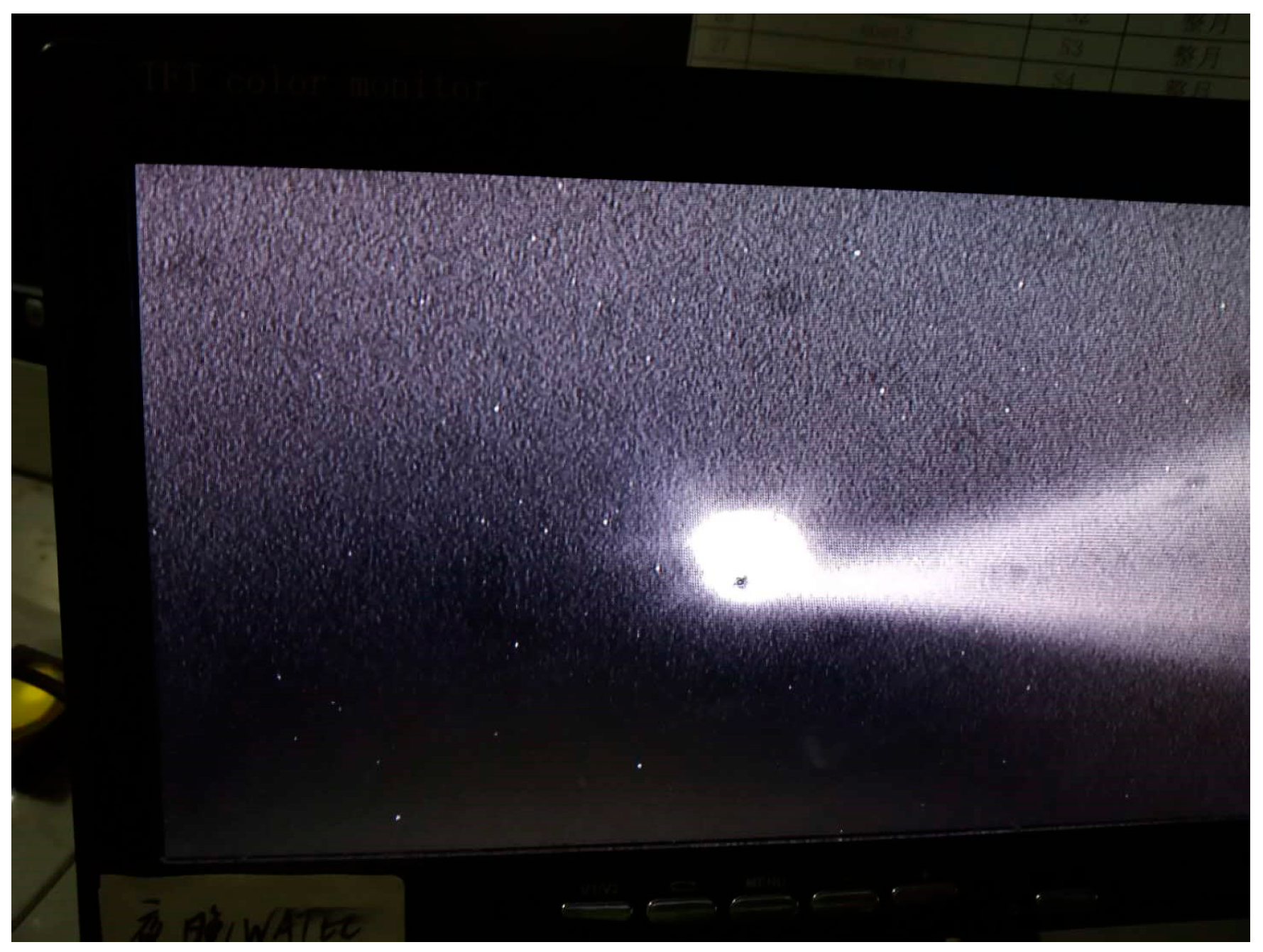
Figure 2 shows the laser ranging experiment for Topex, which was observed on 19 November 2019. The time and range biases of the satellite during the first transit are shown in
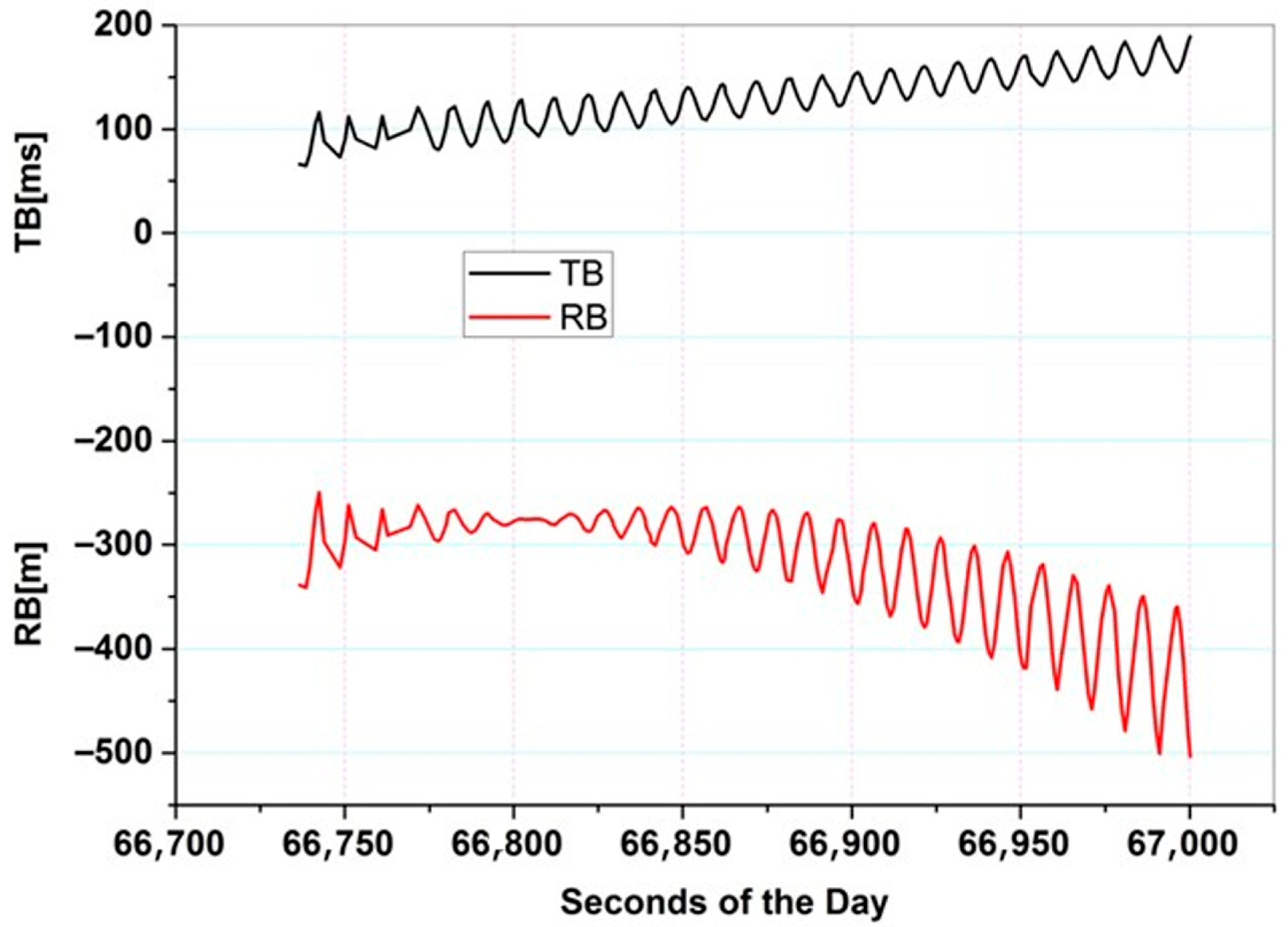
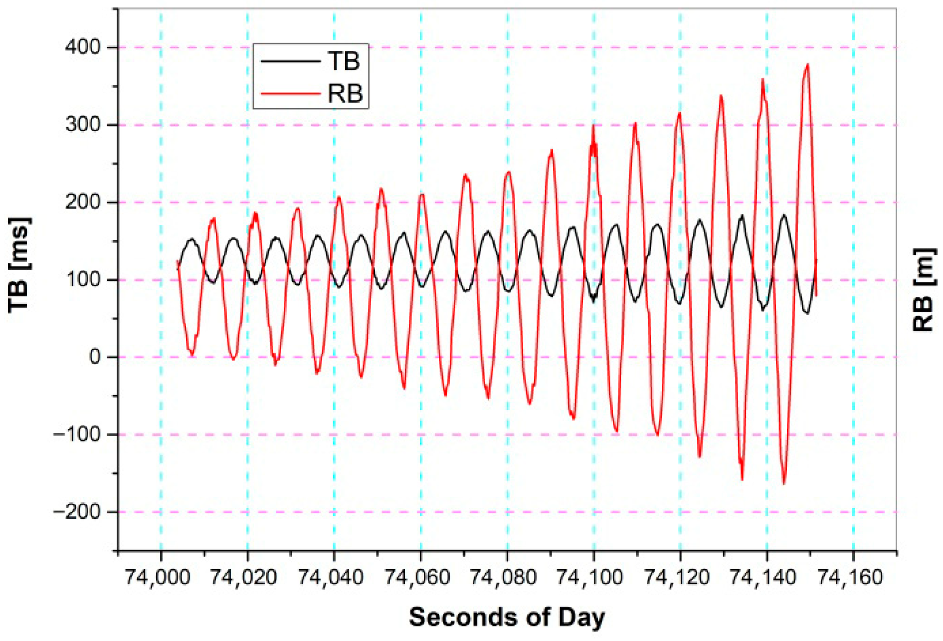
Figure 3. Applying a time bias to the observational process makes it easier to receive the echo signal from the laser and obtain the observational data. The standard points can be obtained by fitting using the cubic spline technique. Then, the time bias and range bias are obtained by comparing the predicted data.
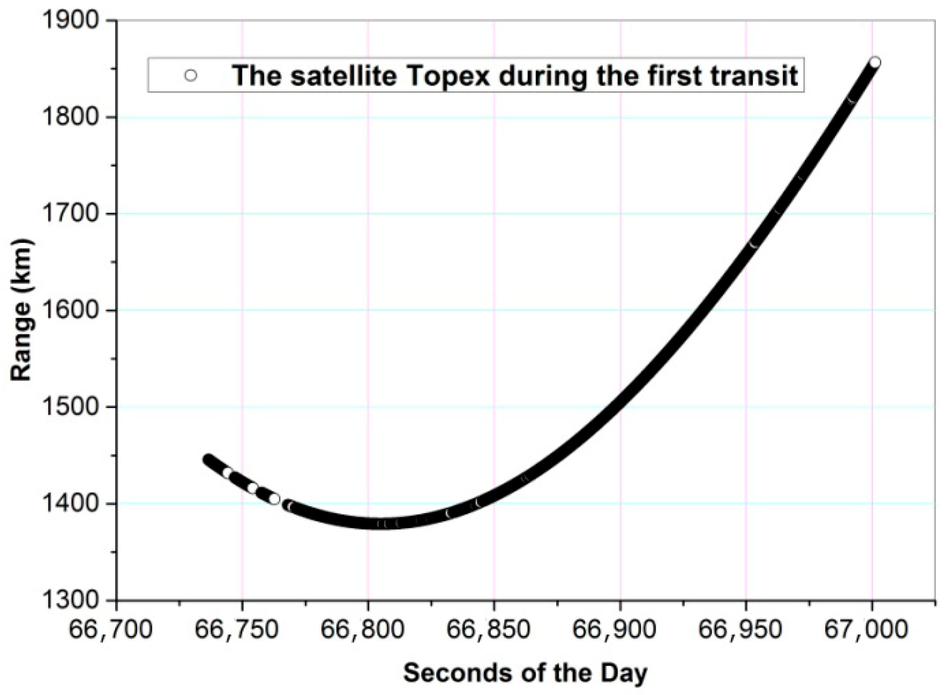
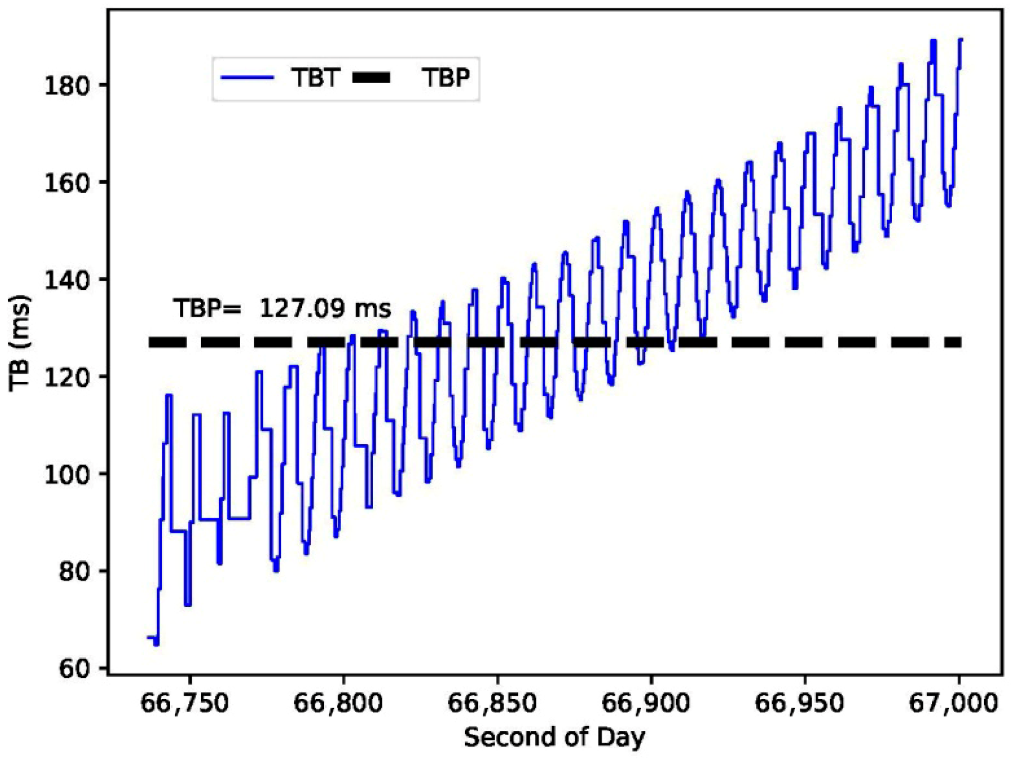
Figure 4 shows the observed range. After processing the results of the data, it can be seen that the Topex satellite has an obvious out-of-control rotation phenomenon. The time bias of the data-processing is 127.09 ms, which is very close to the 120 ms of the pre-processing adjusted time bias; the range bias is −275.02 m, as shown in
Figure 5. Moreover, the Topex satellite did not significantly move in the imaging system, which proves that adding the time bias in advance can improve the tracking of the defunct satellite. Calibration system delay represents the actual, measured instrumental system delay in nanoseconds (ns). It is a constant for the Changchun SLR system during the campaign, determined through regular calibration procedures against known ground targets and satellite passes.
For the second transit, by applying the value of the time bias that we obtained from the first pass, the system in the second pass recognized the data more quickly. The experimental results indicate that during the second pass, applying the prior TB value from the first pass reduced the initial data acquisition time by approximately 60%, on average. Specifically, the first pass typically required about 30–60 s for manual adjustment and signal search to obtain stable echoes, whereas the second pass shortened this process to within 10–20 s, significantly extending the effective observation arc and improving data acquisition efficiency. Although, in the second pass, the object is invisible (not illuminated by the sun), the data are acquired easily. In the second transit of Topex, which starts at 20:21 (nearly two hours later than the first transit), the time bias to 120 ms of the second round of data-processing in advance is adjusted when the angle is low; then, the laser is launched. The operation of the laser ranging of Topex during the second transit is shown in
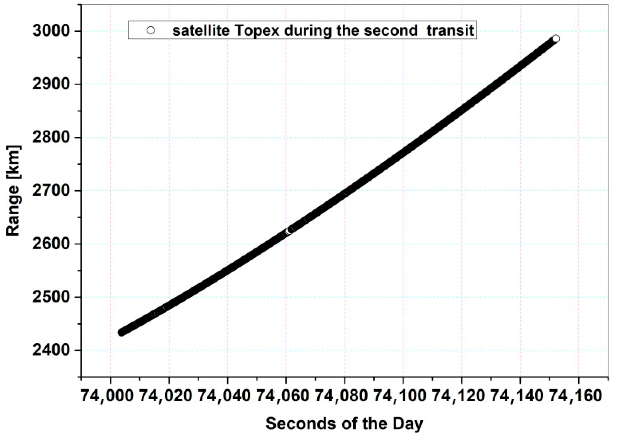
Figure 6. The observational data after partial noise filtering for Topex during the second transit are shown in
Figure 7.
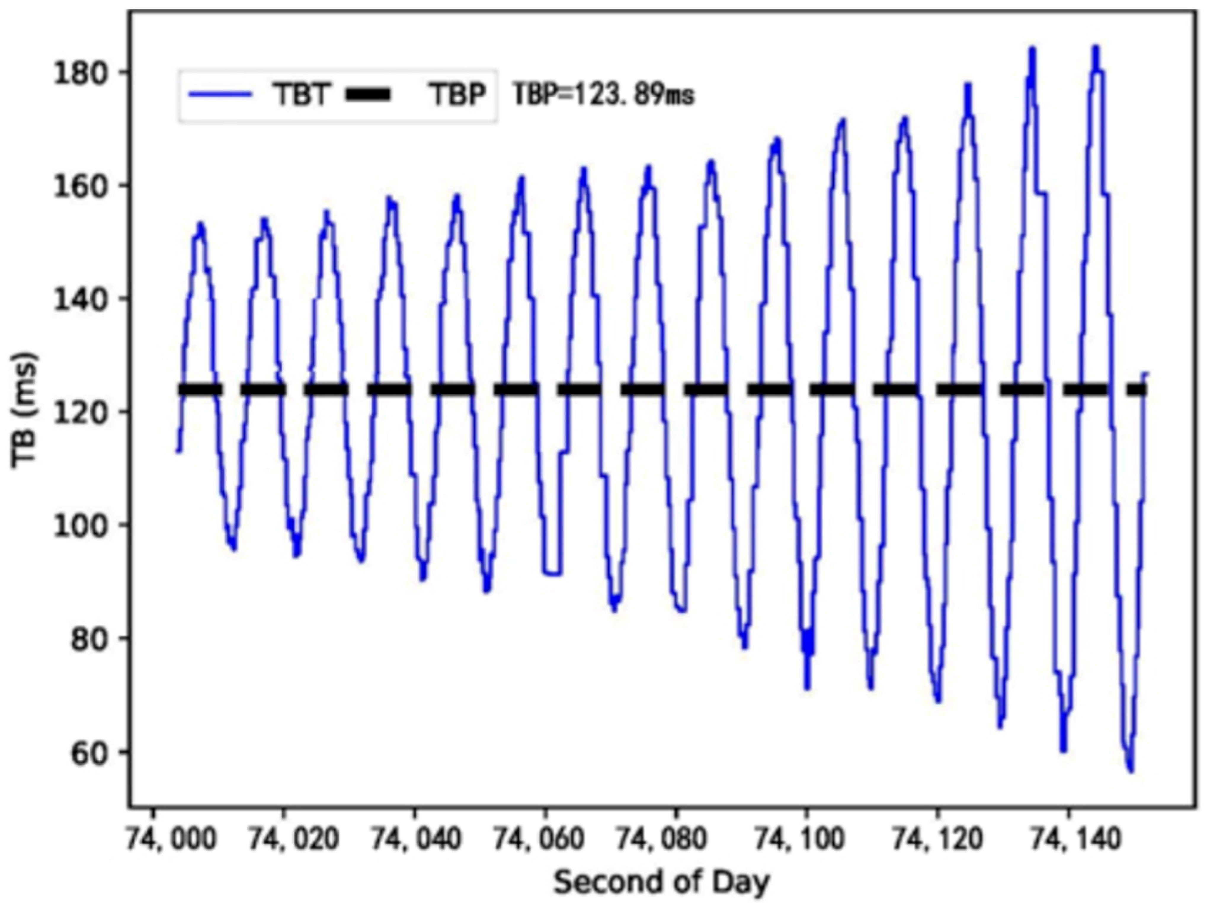
After the data-processing, the time bias of the second round of the Topex satellite is 123.89 ms and the range bias is 92.58 m, when the Topex satellite was added in advance, as shown in
Figure 8. The value of the deviation between them is helpful to reduce the distance threshold, and the system can easily identify the data. That is, from the fitting of the second pass; few changes in are seen in the time bias from the first pass. Therefore, use of the first-time bias on the second pass will help the orbit correction of Topex.
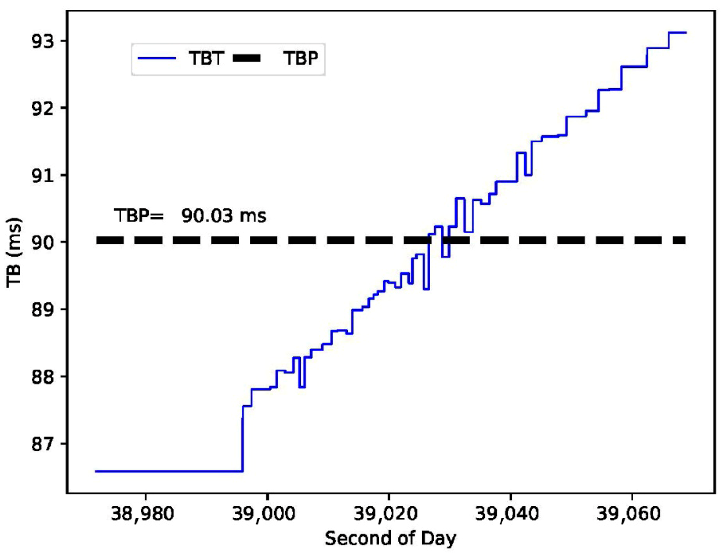
Meanwhile, on 15 November 2019, the same method was applied for the CZ-2C Long March rocket. In the first transit, the time bias was 90.03 ms, which is very close to the 85 ms of the pre-processing adjusted time bias, and the range bias was −110.37 m. In the second transit, CZ-2C’s time bias was adjusted in advance by using the data provided for the first time when it was not visible. Through the method, the experimental data were obtained. At this time, the time bias was 97.58 ms and the range bias was −4.86 m, which proved that the method has a strong practical value for the laser ranging observation of the runaway space targets.
Generally, the described method was applied to two defunct satellites, Topex and CZ-2C, as two examples. The first transit and the second transit were applied with a nearly two-hour time difference. The results obtained for the trials of Topex and CZ-2C were computed; the results are given in
Table 4. The first column shows the name of the object, the date of the observation, the starting time of tracking, the pressure, temperature, and the humidity at the time of tracking, the system delay of the calibration, the number of points used for processing the results, the time bias, and the range bias, respectively.
In the table, we can notice that the methods were applied three times for Topex on 15, 19, and 20 November 2019, and two times for the CZ-2C on 15 and 18 November 2019. The range bias and the time bias are given in the last two columns for the first transit and the second transit, respectively.
6. Conclusions
We introduced a method to observe defunct satellites and the runaway space objects. The method uses the laser ranging technique, as applied to the known method of satellite laser ranging (SLR). In this method, the time bias produced from analyzing the deviations of the orbit prediction of the runaway space objects is added in advance. Then, the observational data from the out-of-control objects (defunct satellites or space debris) are obtained. We applied this method to the defunct Topex satellite and CZ-2C Long March rocket body; the observational data were obtained many times by adding time bias in advance. The results are given in
Table 4.
As an example, by applying the laser ranging for the defunct Topex satellite on 19 November 2019, we found that the time bias of the data-processing result is 127.09 ms, which is very close to the 120 ms of the pre-processing time bias, and the range bias is −275.02 m. For the second transit, by applying the time bias we obtained from the first pass, the system in the second pass can recognize the data more quickly. Although the second pass is invisible, the data can be acquired easily. In the second transit of Topex, which starts at 20:21, the time bias of the second round of the Topex satellite is 123.89 ms, and the range bias is 92.58 m. It is clear that the value of the deviations between them is helpful to reduce the distance threshold; the system can easily identify the data. This means that using the first-time bias on the second pass will help in the orbit correction. It proves that the laser ranging method for runaway space targets is effective. The method proposed in this paper achieves rapid acquisition and high-precision ranging of defunct space targets by decomposing orbit prediction deviations into time bias (TB) and range bias (RB) in real time and applying them collaboratively during observation and data processing. The core advantage of this approach lies in its use of observational results from a prior pass to optimize tracking parameters for the next pass in real time, forming an enhanced closed-loop cycle of “observation–processing–correction–reobservation.” Practical applications show that this strategy effectively addresses challenges, such as inaccurate orbit prediction and short transit times for defunct targets, thereby improving target acquisition efficiency. It holds significant engineering value for safeguarding in-orbit spacecraft and constructing space debris databases.
Author Contributions
Conceptualization, G.W. and S.W.; methodology, Y.Z.; software, M.Z.; validation, G.W., T.L. and M.I.; formal analysis, M.Z.; investigation, Z.L.; resources, X.H.; data curation, S.W.; writing—original draft preparation, G.W.; writing—review and editing, Y.Z.; visualization, X.H.; supervision, C.L.; project administration, C.L.; funding acquisition, G.W. All authors have read and agreed to the published version of the manuscript.
Funding
This research was funded by the Jilin Provincial Department of Science and Technology under the Science and Technology Development Plan Project of Jilin Province. Grant numbers and project titles are as follows: Grant No. 20240404064ZP (“Telescope Laser Ranging and Communication Integration Transformation Project”, Innovation Guidance—Research Infrastructure and Condition Support Program, Large-Scale Scientific Instrument Function Development Project). Grant No. 20250201093GX (“Autonomous Driving System for Sightseeing Buses in Scenic Areas”, Key R&D Program—High-tech Field, Advanced Manufacturing—Key Technologies for Automobiles and Rail Transit Vehicles).
Data Availability Statement
The data presented in this study are available on request from the corresponding author due to the data policy of Changchun Observatory, National Astronomical Observatories, CAS, which restricts public dissemination of satellite observation data for institutional and operational reasons.
Conflicts of Interest
The authors declare that the research was conducted in the absence of any commercial or financial relationships that could be construed as a potential conflict of interest. No external funding, personal relationships, or competing interests influenced the design, execution, or reporting of this study. All authors have reviewed and approved this declaration, and confirm that no conflicts of interest exist.
References
- Maag, C.R.; Deshpande, S.P.; Stevenson, T.J.; Mitzen, P.S. Orbital debris environment as measured at the Mir space station. In Characteristics and Consequences of Orbital Debris and Natural Space Impactors; SPIE: Bellingham, WA, USA, 1996; Volume 2864, pp. 69–75. [Google Scholar]
- Zhang, Z.; Yang, F.; Zhang, H.; Wu, Z.; Chen, J.; Li, P.; Meng, W. The use of laser ranging to measure space debris. Res. Astron. Astrophys. 2012, 12, 212–218. [Google Scholar] [CrossRef]
- Gu, Y.; Li, Z.; Liu, H.; Luo, Q.; Liu, H.; Wu, G. Multi-objective early warning mission planning by multiple satellites using a critical task aggregation-based NSGA-II algorithm. Adv. Space Res. 2025; in press. [Google Scholar] [CrossRef]
- Ediger, W.M.; Ferguson, P.A. Feasibility of Space-Based Laser Ranging for Resident Space Object Detection. In AIAA SCITECH 2025 Forum; American Institute of Aeronautics and Astronautics: Reston, VA, USA, 2025. [Google Scholar]
- Liang, Z.; Han, X.; Fan, C.; Liu, C. Laser ranging observation and orbit determination of rotating reflective CZ-2C rocket stage. In Proceedings of the 20th International Workshop on Laser Ranging, Potsdam, Germany, 9–14 October 2016. [Google Scholar]
- Sang, J.Z.; Bennett, J.C. Achievable debris orbit prediction accuracy using laser ranging data from a single station. Adv. Space Res. 2014, 54, 119–124. [Google Scholar] [CrossRef]
- Han, X.; Dong, X.; Song, Q.; Zhang, H.; Shi, J. Fulfillment of KHz SLR daylight tracking of Changchun Station. In Proceedings of the 17th ILRS Meeting, Fujiyoshida, Japan, 11–15 November 2013. [Google Scholar]
- Ibrahim, M.; Hanna, Y.S.; Samwel, S.W. Statistical and comparative studies for the observations of Helwan-SLR station. Int. J. Nonlinear Sci. Numer. Simul. 2004, 5, 135–147. [Google Scholar] [CrossRef]
- Ibrahim, M. 17 years of ranging from the Helwan-SLR station. Astrophys. Space Sci. 2011, 335, 379–387. [Google Scholar] [CrossRef]
- Kirchner, G.; Koidl, F. Graz KHz SLR system: Design, experiences and results. In Proceedings of the 14th International Workshop on Laser Ranging, San Fernando, Spain, 7–11 June 2004. [Google Scholar]
- Pearlman, M.R.; Degnan, J.J.; Bosworth, J.M. The International Laser Ranging Service. Adv. Space Res. 2002, 30, 135–143. [Google Scholar] [CrossRef]
- Zhao, Y.; Fan, C.; Han, X.; Liu, C.; Li, Z.; Song, Q.; Dong, X. Design and development of an optoelectronic detecting system for space debris. In Proceedings of the International Conference on Optical Instruments and Technology: Optical Systems and Optoelectronic Instruments, Beijing, China, 16–19 November 2008; SPIE: Bellingham, WA, USA, 2009; Volume 7156, p. 71560O. [Google Scholar]
- Arnold, D.; Montenbruck, O.; Hackel, S.; Sosnica, K. Satellite laser ranging to low Earth orbiters: Orbit and network validation. J. Geod. 2019, 93, 2315–2334. [Google Scholar] [CrossRef]
- Otsubo, T.; Matsuo, K.; Aoyama, Y.; Yamamoto, K.; Hobiger, T.; Kubo-OKA, T.; Sekido, M. Effective expansion of satellite laser ranging network to improve global geodetic parameters. Earth Planets Space 2016, 68, 65. [Google Scholar] [CrossRef]
- Rutkowska, M.; Jagoda, M. Estimation of the elastic earth parameters using slr data for the low satellites STARLETTE and STELLA. Acta Geophys. 2012, 60, 1213–1223. [Google Scholar] [CrossRef]
- Kirchner, G.; Koidl, F.; Friederich, F.; Buske, I.; Völker, U.; Riede, W. Laser measurements of space debris from Graz SLR station. Adv. Space Res. 2013, 51, 21–24. [Google Scholar] [CrossRef]
- Myrtille, L.; Sebastien, W.; Florent, D. First astrometric observations of space debris with the MEO telescope. Adv. Space Res. 2011, 49, 603–611. [Google Scholar]
- Sang, J.; Smith, C.; Zhang, K. Towards accurate atmospheric mass density determination using precise positional information of space objects. Adv. Space Res. 2012, 49, 1088–1096. [Google Scholar] [CrossRef]
- Gong, Z.Z.; Xu, K.; Mu, Y.; Cao, Y. The space debris environment and the active debris removal techniques. Spacecr. Environ. Eng. 2014, 31, 129–135. [Google Scholar]
- Liang, Z.; Dong, X.; Ibrahim, M.; Song, Q.; Han, X.; Liu, C.; Zhang, H.; Zha, G. Tracking the space debris from the Changchun Observatory. Astrophys. Space Sci. 2019, 364, 201. [Google Scholar] [CrossRef]
- Ibrahim, M.; Abd El-Hameed, A.; Attia, G. Analytical studies of laser parameters for ranging and illuminating satellites from H-SLR station. Space Res. J. 2010, 4, 71–78. [Google Scholar] [CrossRef]
- Ibrahim, M.; Abd El-Hameed, A.; Liang, Z.; Han, X. Analytical investigation for the satellite ranging data of Changchun SLR station. NRIAG J. Astron. Geophys. 2020, 9, 321–329. [Google Scholar] [CrossRef]
- Montenbruck, O.; Gill, E. Satellite Orbits-Models, Methods and Applications. Appl. Mech. Rev. 2002, 55, B27–B28. [Google Scholar] [CrossRef]
- McCarthy, D.; Petit, G. (Eds.) IERS Technical Note No.32; IERS Conventions Centre: Paris, France, 2003. [Google Scholar]
- Combrinck, L.; Suberlak, V. Earth-tide as parameter of crustal motion correction for SLR station displacement. S. Afr. J. Geol. 2007, 110, 203–210. [Google Scholar] [CrossRef]
- Li, Y.; Wang, X.; Zhong, S.; Xi, K. The influence of considering atmospheric wind field for atmospheric drag on SLR orbit determination. Adv. Space Res. 2024, 74, 975–986. [Google Scholar] [CrossRef]
- Panzetta, F.; Blossfeld, M.; Erdogan, E.; Rudenko, S.; Schmidt, M.; Mueller, H. Towards thermospheric density estimation from SLR observations of LEO satellites: A case study with ANDE-Pollux satellite. J. Geod. 2019, 93, 353–368. [Google Scholar] [CrossRef]
- Hanna, Y.S.; Ibrahim, M.; Samwel, S.W. On using Chebyshev polynomials for fitting SLR data of artificial satellites. Appl. Math. Comput. 2004, 158, 655–666. [Google Scholar] [CrossRef]
| Disclaimer/Publisher’s Note: The statements, opinions and data contained in all publications are solely those of the individual author(s) and contributor(s) and not of MDPI and/or the editor(s). MDPI and/or the editor(s) disclaim responsibility for any injury to people or property resulting from any ideas, methods, instructions or products referred to in the content. |





 ,
,