1. Introduction
When a large-scale disaster, e.g., an earthquake, occurs, each evacuee should move to an appropriate refuge in a speedy and safe manner. Such speedy and reliable evacuation can be achieved by both pre-disaster and post-disaster approaches. The pre-disaster approaches include establishment of refuges [
1,
2,
3,
4,
5,
6], refuge assignment [
7,
8,
9], evacuation planning [
10,
11,
12], and geographical risk analysis [
13,
14,
15,
16,
17]. From the viewpoint of the refuge assignment, most of the existing studies basically consider the evacuation time and refuge capacity while the safety evacuation is also important.
The pre-disaster approaches can provide us with a global picture of evacuation under predefined assumptions (e.g., refuge locations, geographical population distribution, and road network risk). Since it is difficult to consider all possible disaster situations, the post-disaster approaches are also important to compensate for the mismatch between the assumptions and actual situations.
The post-disaster approaches include evacuation guiding [
18,
19,
20] and signage systems [
21,
22,
23]. In comparison with the pre-disaster approaches, the post-disaster ones can flexibly deal with dynamic environmental changes due to the disaster for supporting the evacuees’ decision making under their high-stressed situation. However, most of the post-disaster approaches implicitly assume that each evacuee selects the nearest refuge for evacuation, which might guide the evacuee to a less reliable route and/or to a filled refuge. In recent years, we can obtain the safety-related information (e.g., geographical risk information) in addition to the capacity-related information (e.g., population distribution and refuge locations and capacities) from governments and some municipalities [
13,
14,
15].
In this paper, we consider the earthquake case study and propose a refuge assignment scheme to achieve speedy and safety evacuations under the refuge capacity constraint. This is a kind of the multi-objective optimization problems, i.e., minimization of route length and maximization of route reliability.
We first formulate the refuge assignment problem as a two-step integer linear program (ILP) under the input of route candidates between evacuees and their possible refuges, which can be solved by the existing solver, CPLEX [
24]. As for the route candidates, we also propose a speedy and reliable path selection scheme, which is an extended version of the existing path selection scheme [
20] to improve the route reliability.
The proposed scheme can be viewed as either pre-disaster approach or post-disaster one, depending on the knowledge about the locations of evacuees. If the proposed scheme uses the geographical distribution of residents as their initial locations, it can be viewed as pre-disaster refuge assignment for evacuation planning. On the other hand, if it can obtain the actual locations of evacuees under the disaster situations through information and communication technologies (e.g., mobile devices, global positioning systems, and communication networks), it can also achieve post-disaster refuge assignment, which is responsive to the environmental changes.
In this paper, we mainly focus on the pre-disaster refuge assignment under the earthquake case study using actual geographical data (i.e., road blockage probabilities, map of Nagoya city, locations and capacities of refuges, and the distribution of residents), which are provided by the Japanese government and municipality [
13,
25,
26,
27].
Through numerical results using the actual data of Arako district of Nagoya city, in Japan, we will show the effectiveness of the proposed refuge assignment scheme in terms of speediness and safety of evacuation under the refuge capacity constraints.
The rest of this paper is organized as follows.
Section 2 gives related work. In
Section 3, we introduce the proposed scheme. After showing numerical results in
Section 4, we finally give conclusions and future work in
Section 5.
3. Capacitated Refuge Assignment for Speedy and Reliable Evacuation
Refuge assignment for evacuees is a kind of combinational optimization problems where we require consideration of multiple important features of evacuation (i.e., speediness, safety, and capacity constraint of refuges).
We first provide notations and criteria for evacuation route, i.e., speediness and reliability, in
Section 3.1 and explain the overview of the proposed refuge assignment scheme in
Section 3.2. Next, we formulate such refuge assignment as a two-step ILP in
Section 3.3. We further propose an algorithm to calculate speedy and reliable route candidates between evacuees and their possible refuges in
Section 3.4.
3.1. Preliminaries
Since the refuge assignment is part of the evacuation planning, we focus on the target area for the evacuation planning. In Japan, the unit of the target area is typically a school district and the mayor of municipality must determine designated emergency evacuation site for each disaster type (e.g., earthquake and flood) [
45].
denotes the graph representing the internal structure of the target area, where
is a set of vertices i.e., intersections or refuges, and
is a set of edges i.e., roads. There are
D refuges denoted by
such that
. Suppose that there are
evacuees, denoted by
, and each evacuee
i is initially located at vertex
in the target area.
To calculate the refuge assignment, we require the initial locations of the evacuees. The refuge assignment can be regarded as either pre-disaster approach or post-disaster one, according to the knowledge about the initial locations of the evacuees. From the viewpoint of the pre-disaster refuge assignment, the geographical distribution of residents [
27] can be used as possible initial locations of evacuees (residents). We can also adopt the time-varying geographical population distribution (e.g., People Flow Data [
14]) to consider the initial locations of evacuees under human life cycle (e.g., commuting period in the morning and returning period in the evening). On the other hand, from the viewpoint of the post-disaster refuge assignment, we can collect the actual locations of the evacuees through their mobile devices at the beginning of a disaster if the terrestrial communication infrastructure (e.g., cellular networks and Wi-Fi) is working.
If the terrestrial communication infrastructures are (partly) damaged and unavailable, we can also use device to device (D2D) communication through evacuees’ mobile devices [
38,
46] and devices with satellite connectivity [
47]. Please note that such post-disaster information collection would be affected not only by communication environments but also by the penetration ratio of the proposed scheme as well as evacuees’ privacy settings for their location information. If the post-disaster refuge assignment cannot obtain the actual locations of evacuees, it can also adopt the above-mentioned statistical information as in the pre-disaster one. In what follows, we mainly focus on the pre-disaster refuge assignment where the geographical distribution of residents is used as the initial locations of the evacuees.
The map matching algorithm [
48] can find the nearest vertex of the internal graph from a coordinate-based location.
is a real-valued function that assigns road blockage probability
in closed unit interval
to each edge
in the risk map. Road blockage probability
is an estimated probability that road segment
is blocked due to the collapse of building along a road under a certain earthquake [
13]. The detailed definition of the road blockage probability is explained in
Appendix A.
An evacuation route
r can be represented by a vector of roads. We define the length of route
r as the sum of the length of each road
e in
r:
where
is the length of road
e. In addition, we can also define the route reliability as follows [
20]:
which is the probability that all the roads
e along the route
r are passable under the assumption that the road blockage probabilities along the routes are independent. The route reliability takes a value in the range of
and a large (resp. small) value means high (resp. low) reliability. We can obtain the geographical information (e.g., the location of the refuge, the refuge capacity, and the distribution of residents) from the government and the municipalities before the disaster occurs [
14,
26,
27]. Each refuge
has a capacity of
persons.
denotes a set of refuge capacity.
Table 1 summarizes notations used in this paper.
3.2. Overview of Proposed Refuge Assignment Scheme
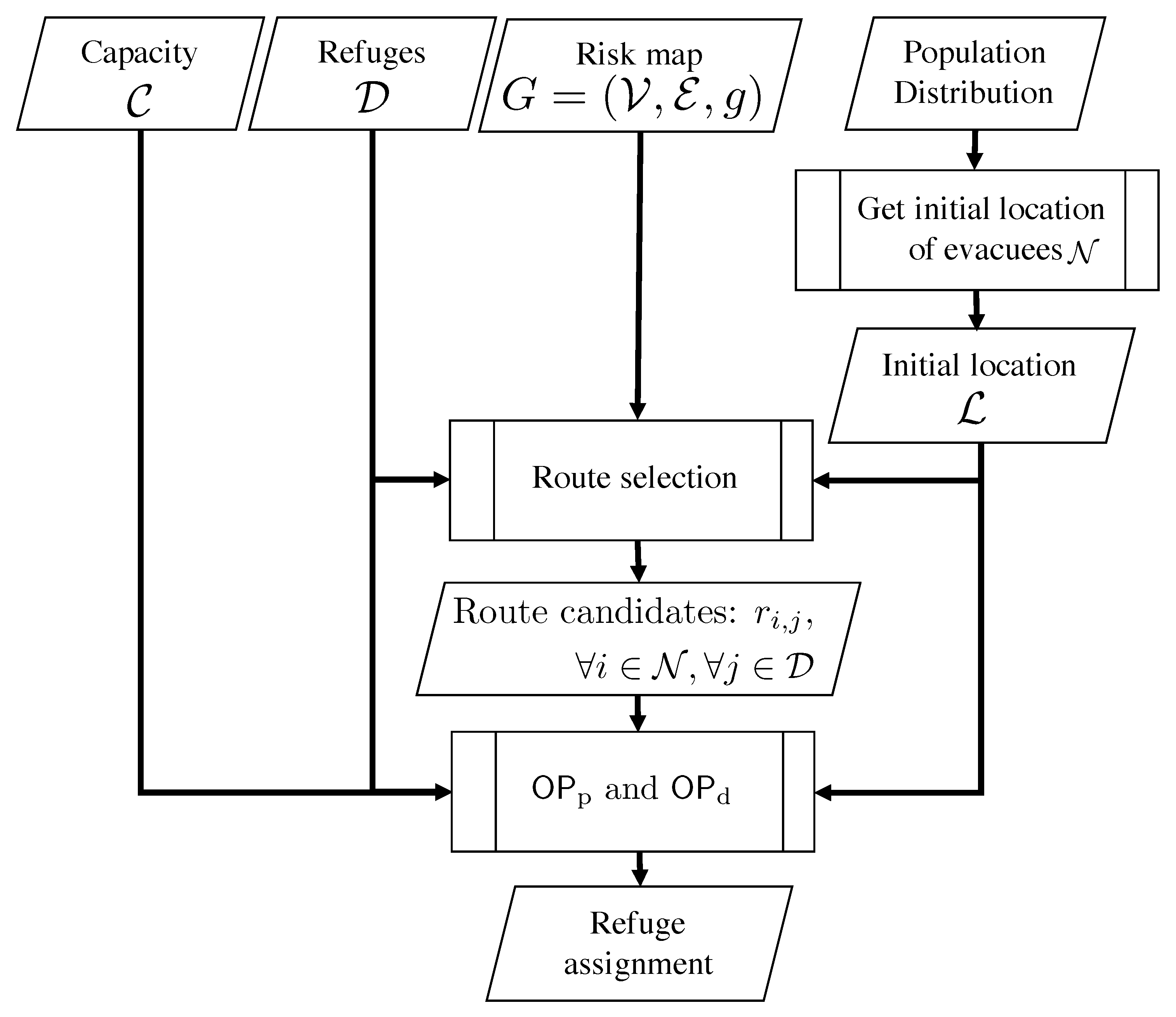
In this subsection, we introduce the overview of the proposed refuge assignment scheme.
Figure 1 illustrates the flow chart of conducting the refuge assignment and route candidate. We first calculate the initial locations of evacuees from the geographical distribution of residents [
27].
Since the geographical distribution of residents gives us the number of persons in each sub-region q, , we uniformly allocate evacuees to the vertices in the sub-region q. Let denote the set of sub-regions, and thus .
Considering the fact that some of the residents may stay their home or workplace even under the emergency, we further assume that () ratio of all the residents act as evacuees, denoted by . In such cases, we can regard as .
Next, given risk map
, set of refuges
, set of refuge capacity
, set of evacuees
, and initial locations of evacuees
, we obtain the route candidates
between all evacuees
and all refuges
using Algorithm 2, which will be described in
Section 3.4. Finally, the refuge assignment is obtained by solving ILPs,
and/or
, which will be described in
Section 3.3.
3.3. Two-Step ILP Formulation for Refuge Assignment
As mentioned above, the refuge assignment must be carefully designed by considering the speediness and safety of evacuation under the refuge capacity constraint. This is a kind of multi-objective optimization problems, and thus we tackle this problem in the following two-step ILP.
3.3.1. First Step: Maximization of Average Route Reliability among Evacuees under Refuge Capacity Constraint
Given route candidates between evacuees and their possible refuges as the input data, which will be explained in
Section 3.4, we first aim at maximizing the evacuation safety, i.e., the average route reliability among evacuees. This optimization problem can be represented by the following ILP
.
The objective function (
3) is the maximization of the average road reliability among evacuees, where
is the route candidate between evacuee
i and refuge
j. The calculation of
will be described in
Section 3.4.
is binary decision variable given by (4). If evacuee
i is assigned to refuge
j,
. Otherwise,
. The constraint of (5) guarantees that each evacuee
i must be allocated to one refuge. Since the overflow evacuees will be required to move to other refuges [
49], such overflow conditions are prohibited by (6), which indicates that the number of evacuees assigned to each refuge does not exceed the corresponding capacity.
Since the objective function and all the constraints are linear with the binary decision variables, is ILP, which can be solved by the existing solver, e.g., CPLEX.
3.3.2. Second Step: Minimization of Average Route Length among Evacuees under Refuge Capacity Constraint and Average Route Reliability
By solving the problem , we can obtain the optimal value of the average route reliability . The corresponding refuge assignment, however, may have some room to improve in terms of speedy evacuation. To tackle this trade-off between the speediness and reliability, we further propose a second-step optimization as an ILP , which can be formulated by modifying as follows.
First, the objective function (
3) is replaced with
which is the minimization of the average route length among evacuees. In addition to the constraints of
, i.e., (4)–(6),
adds the following constraint:
The constraint of (
8) guarantees a certain level of the average route availability by controlling a parameter
, which describes the allowable decrease of average route reliability from the optimal value
. If
is small (resp. large), the refuge assignment is designed for reliable (speedy) evacuation.
The appropriate setting for
will be discussed in
Section 4.2. Since the objective function and all the constraints are linear with the binary variables,
is also ILP.
3.4. Calculation of Speedy and Reliable Route Candidates between Evacuees and Their Possible Refuges
The solution, i.e., refuge assignment, of the two-step ILP depends on its input parameters, which are the route candidates between evacuees and their possible refuges, i.e.,
. We propose a speedy and reliable route selection scheme, which is an extended version of the existing route selection scheme [
20].
Algorithm 1 presents a function
that enumerates at most
shortest route candidates between evacuee
i and refuge
j under the constraint on route length,
, and route reliability,
. Given road network
, evacuee
i, refuge
j, parameters
, and
, it first initializes the set of route candidates,
, to be empty and the shortest route length
to be infinity (line 1). Next, it obtains at most
shortest route candidates between evacuee
i and refuge
j,
, by using
k function based on Yen’s algorithm [
50] (line 2). It also calculates the length of the shortest path in
,
(line 3). In the next loop of lines 4–8, it extracts speedy and reliable route candidates from
. Please note that route candidates in
are sorted in ascending order of route length. If the length of route
r is longer than that of the shortest path, i.e.,
, at a certain level,
, it stops the loop (lines 5–6). If the reliability of route
r is equal or greater than a threshold
, it adds
r to
(line 8). Please note that the existing scheme in [
20] does not have this operation, and thus the road reliability is considered in the best effort manner. After the loop, it returns
as the speedy and reliable route candidates.
| Algorithm 1: Enumeration of at most shortest route candidates between evacuee i and refuge j under constraint on route length, , and route reliability, . |
| Require: |
| Ensure: |
| 1: , | ▹ Initialization |
| 2: ←k | ▹ Calculation of the -shortest routes |
| 3: | ▹ Calculation of the length of the shortest route |
| 4: for do |
| 5: if then | ▹ Check on the route length condition |
| 6: break |
| 7: if then | ▹ Check on the route reliability condition |
| 8: |
| 9: return |
The route candidates in
change depending on the parameters
,
, and
.
and
controls the diversity and speediness of route candidates [
20].
can be as large as possible under the constraint on the computation overhead.
can also be a moderate value by considering both the speedy evacuation and reliable route discovery. On the contrary, the setting of
tends to be difficult because the feasible route reliability between evacuee
i and refuge
j can change depending on the pair of
i and
j.
Considering these features, we propose a function
that calculates the speedy and reliable route candidate
between evacuee
i and refuge
j (Algorithm 2). Given road network
, evacuee
i, refuge
j, and parameters
,
, it first initializes
to be the maximum value, i.e., one, and
to be an empty set (line 1). In the next loop of lines 2–6, it searches for the most reliable route candidate
between evacuee
i and refuge
j under the constraint on
and
, by decreasing
at a certain interval,
, e.g.,
. If it succeeds in finding route candidates
using
(line 3), it selects the most reliable one as follows (line 5):
Otherwise, If
is empty, it continues searching for the route candidates by setting
(line 6). As a result, Algorithm 2 provides us with speedy and reliable route candidate
between evacuee
i and refuge
j.
| Algorithm 2: Calculation of speedy and reliable route candidate between evacuee i and refuge j. |
| Require: |
| Ensure: |
| 1: , | ▹ Initialization |
| 2: while do |
| 3: | ▹ Calculation of the route candidates |
| 4: if then |
| 5: return according to (9) | ▹ Calculation of the speedy and reliable route candidate |
| 6: | ▹ Update of |
4. Numerical Results
In this section, we evaluate the refuge assignment obtained by solving the two-step ILP, and , using the actual information.
4.1. Evaluation Model
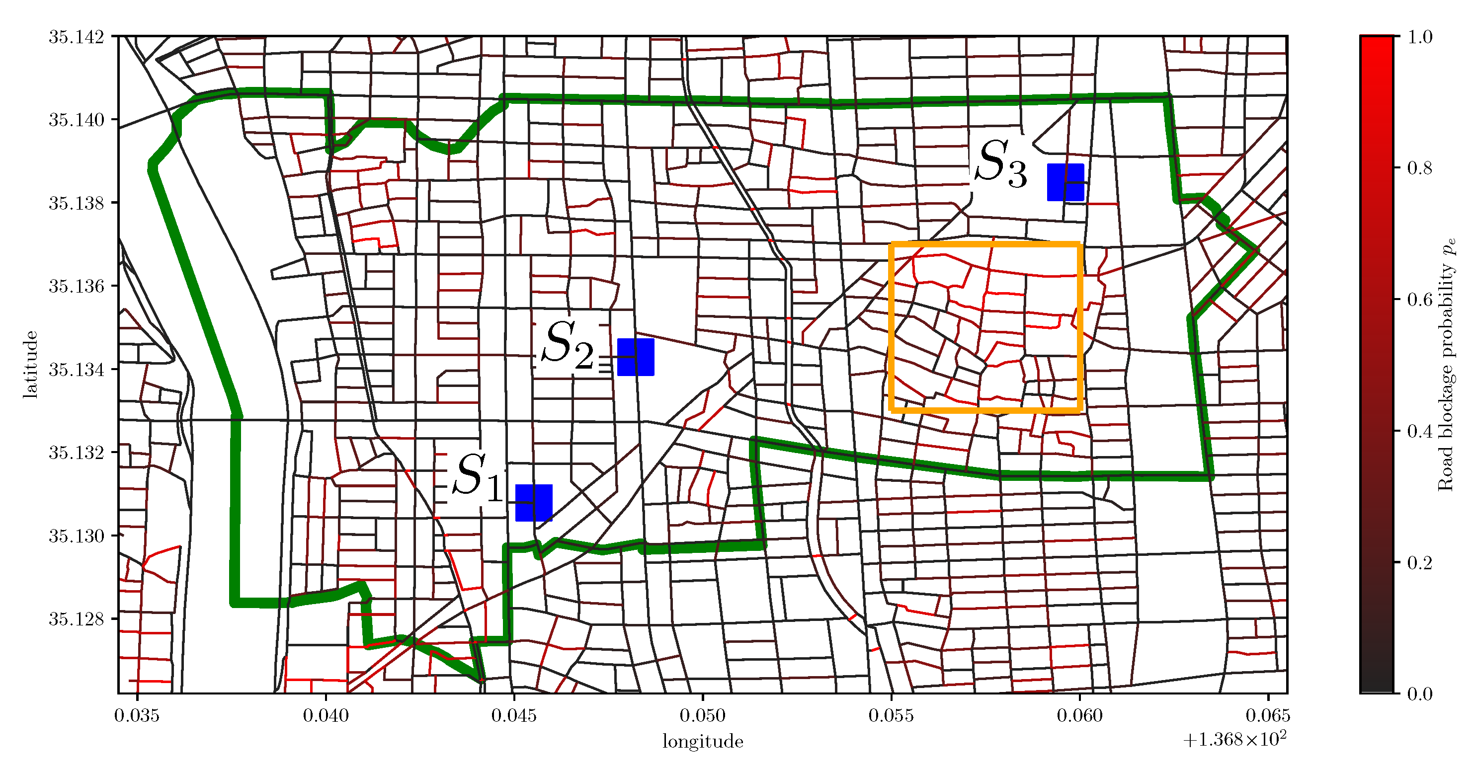
For the evaluation, we select Nagoya city in Japan because it provides us with the risk map where each road is annotated by the road blockage probability [
13]. There are 263 school districts, each of which is the unit of evacuation planning [
25]. We select Arako district from them by considering the high average road blockage probability. The green area in
Figure 2 shows the risk map of
Arako district. This map’s internal graph structure is composed of 801 vertices and 1220 edges.
As for the disaster scenario, Nagoya city provides us with the information of the road blockage probabilities for several classes depending on the degree of damages. In this paper, we use the data of maximum class that consider Nankai megathrust earthquake. Each road in
Figure 2 is colored according to the road blockage probability: red (resp. black) means high (resp. low) road blockage probability. The average road blockage probability among all roads is 0.151. The orange area in
Figure 2 contains the roads with high road blockage probability, i.e., the average road blockage probability in this area is 0.278. We also show the three actual refuges
as blue points in
Figure 2, according to [
26]. The capacity of each refuge is given as
11,500,
1964, and
8000.
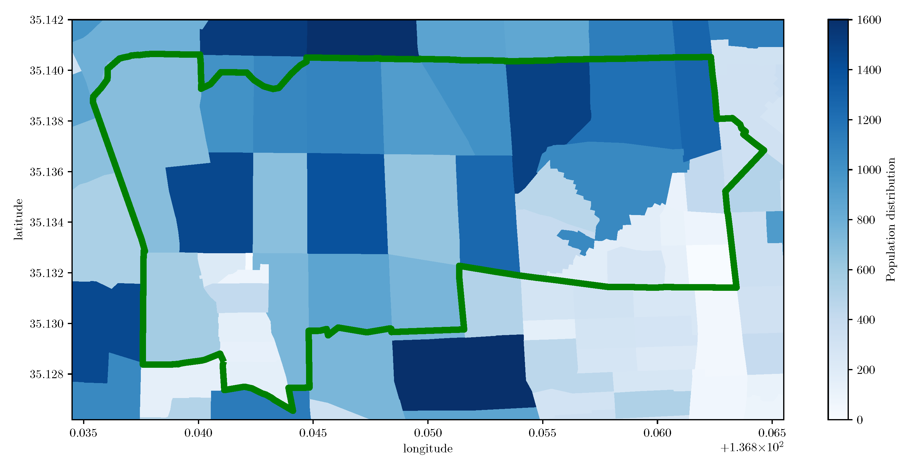
There are 23,156 residents in Arako district [
27] and the geographical distribution of residents is shown in
Figure 3. We confirm that the three refuges cannot accommodate all the residents, i.e.,
21,464 < 23,156.
In what follows, we set to be 0.7 as an example scenario where some of the residents stay their home or workplace even under the emergency.
For comparison purpose, we use the three schemes depending on the combination of the refuge assignment and the route selection, as shown in
Table 2. The distance-based scheme only considers the minimization of the average route length among evacuees, which can be obtained by solving a modified version of ILP
where constraint (
8) is removed.
We use two kinds of criteria. The first one is the average route length,
, to evaluate the speediness of the evacuation, which corresponds to the objective function (
7). The second one is the average route reliability,
, which is related to the objective function (
3).
In what follows, we show the average of ten independent numerical results, each of which has different initial locations of evacuees. Through preliminary experiments, we set the parameters for the route selection as follows: 5000, 300, and 0.1.
4.2. Analysis of Trade-Off between Speediness and Safety under Capacity Constraint
In this subsection, we show the performance of the proposed scheme compared with the distance-based scheme under the capacity constraint.
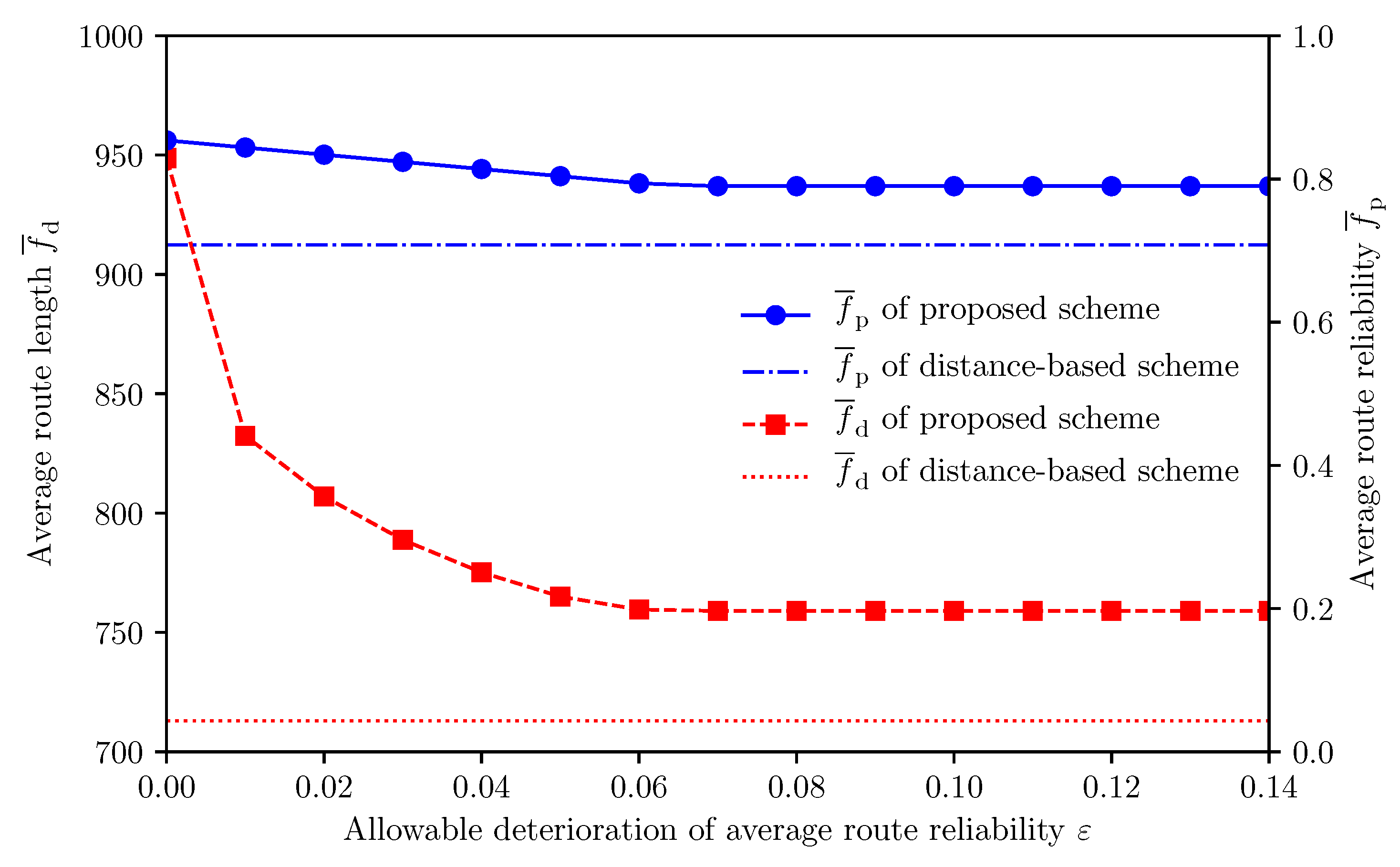
Figure 4 illustrates how the allowable deterioration of average route reliability
affects the average route length
and average route reliability
in case of relatively large evacuation demand, i.e.,
. We first focus on the performance of the proposed scheme. Since small (resp. large)
places emphasis on the average route reliability (resp. average route length), we observe that
and
of the proposed scheme decrease with increase in
. We observe that
is one of the appropriate parameter settings in terms of both speedy and reliable evacuation. In particular, the proposed scheme can improve
by 13.6% with 7.3% increase of
, compared with the distance-based scheme. In what follows, we set
to be 0.05. In actual cases, the value of
may also be affected by other factors, e.g., political judgment.
Next, we focus on the obtained refuge assignment.
Figure 5 and
Figure 6 illustrate the refuge assignment of the distance-based scheme and that of the proposed scheme, respectively. Recall that the orange area in
Figure 2 contains the roads with high road blockage probability, i.e., the average road blockage probability in this area is 0.278. In the orange area of
Figure 5, some evacuees assigned to
are forced to pass through the area with high road blockage probability. Comparing the orange areas in
Figure 5 and
Figure 6, we confirm that the proposed scheme can reduce such unsafe evacuation by assigning them to
.
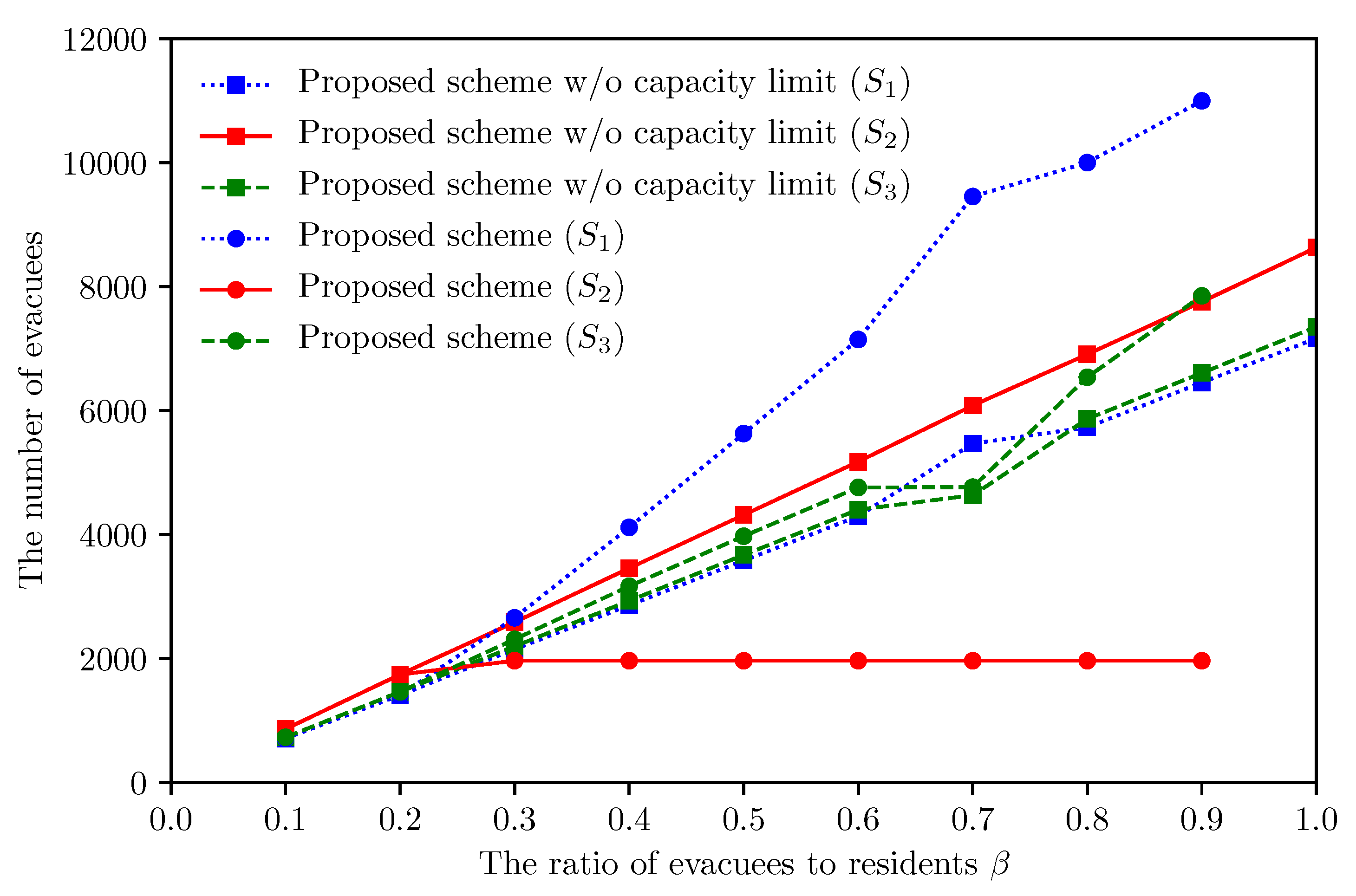
To deeply analyze the characteristics of the proposed scheme, we further show the detailed results per refuge.
Figure 7,
Figure 8 and
Figure 9 illustrate how
affects the number of allocated evacuees,
, and
, per refuge, respectively. We first focus on refuge
. We observe that
decreases with
while keeping the number of allocated evacuees, due to the capacity limit (6). Specifically, we confirm that
of
can improve by 35.9%, i.e., 392.0 [
], by comparing the result of
with that of
. This result means that evacuees near refuge
are assigned to
by the relaxation of the constraint (
8). On the contrary, we observe that
of
increases with
, which indicates that part of evacuees cannot be assigned to their appropriate refuges, due to the capacity limit (6) in case of
. We will describe the details of this result in
Section 4.3.
Finally, we focus on refuges and . We confirm that of and the number of allocated evacuees of decrease with . This phenomenon can be explained as follows. At first, evacuees distant from are assigned to in case of , to improve the average route reliability. By increasing , these evacuees can be assigned to nearer refuges, and , but most of them can only be assigned to the refuge , due to the limited capacity of . As a result, the number of evacuees allocated to increases with . This forces some of them to pass through the area with high road blockage probability, and thus of decreases with .
4.3. Impact of Capacity Limit on Speedy and Reliable Evacuation
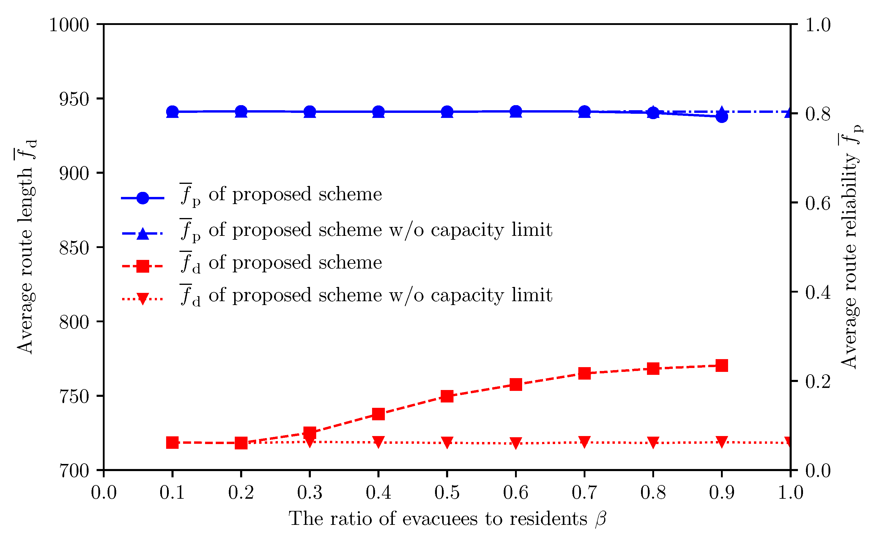
In this subsection, we examine the appropriate design for the refuge capacity by comparing the proposed scheme and that without the capacity constraint, which can be regarded as an ideal case.
Figure 10 presents the refuge assignment of the proposed scheme without the capacity constraint when
. Comparing
Figure 6 with
Figure 10, we first confirm that the proposed scheme without the capacity constraint assigns more evacuees to refuge
. This result indicates that the demand for the refuge
significantly exceeds the current refuge capacity
.
Figure 11 illustrates how the impact of
on
and
changes between the proposed scheme and that without the capacity constraint.
Figure 12 shows the corresponding result per refuge. We observe that the proposed scheme increases
by 6.5% compared with the proposed scheme without (6) when
. This is because the capacity of refuge
lacks 4118 of the actual demand as shown in
Figure 12. In the proposed scheme, the overflow evacuees tend to be assigned to
, which has sufficient capacity and is located at relatively safe region. In
Figure 11, we also confirm that the proposed scheme keeps
regardless of
, compared with the proposed scheme without the capacity constraint.
These results indicate that the current setting for refuge capacity should be reconsidered especially for refuge . In other words, the proposed scheme can be used to a tool to calculate the required capacity of each refuge for speedy and reliable evacuation.
4.4. Discussion
At the last of this section, we briefly discuss the limit of the proposed scheme from the viewpoint of implementation in real-world context. The refuge assignment based on the proposed scheme should be announced/advertised to evacuees before their evacuations. We expect that the cooperation with the mobile-cloud collaborative automatic evacuation guiding system [
19] is one possible way. In this system, the mobile application of an evacuee can automatically estimate the actual road state (i.e., passable or blocked) during the evacuation, with the help of the implicit interactions with its owner. The estimated information will be shared with other mobile devices (evacuees) and cloud through the terrestrial communication networks (e.g., cellular networks and Wi-Fi) and/or D2D communication. These dynamically obtained information can be used to update the refuge assignment.
5. Conclusions
When a large-scale disaster occurs, each evacuee should move to an appropriate refuge in a speedy and safe manner. This can be achieved by the combination of both pre-disaster and post-disaster approaches. In this paper, we have considered an earthquake case study and proposed a refuge assignment scheme that can support speedy and reliable evacuation under the refuge capacity constraint. Given route candidates between evacuees and their possible refuges, we have first formulated the refuge assignment problem as the two-step ILP, which minimizes the average route length while guaranteeing a certain level of the average route reliability under the constraint on the refuge capacity. As for the route candidates, we have further proposed a speedy and reliable route selection scheme that generates the input of the two-step ILP, i.e., route candidates between evacuees and their possible refuges.
Through numerical results using the actual data of Arako district of Nagoya city in Japan, representative results have shown that (1) the proposed scheme can control the balance between the evacuation speediness and reliability under the refuge capacity constraint by adjusting a control parameter and (2) the proposed scheme with the appropriate parameter setting can improve the average route reliability by 13.6% while suppressing the increase of the average route length by 7.3%, compared with the distance-based scheme. In addition, we have also revealed that the proposed scheme can be used as a tool to reconsider the current settings for the refuge capacity. In particular, we have demonstrated that the capacity of a certain refuge lacks 4,118 of the actual demands, which increases the average route length by 6.5%.
In future work, we plan to conduct a comprehensive survey of the potential risks in other districts of Nagoya city.


