User-Comfort Pathfinding: Integrating Thermal Imagery and Street-Level Vegetation Analysis into Multi-Criteria Pedestrian Routing


Abstract
1. Introduction
- A reproducible pipeline for extracting pedestrian-perspective tree-canopy coverage from Google Street View imagery using a transformer-based semantic segmentation model, applied across the historic center of Clermont-Ferrand, France.
- A multi-criteria edge-cost formulation integrates airborne-derived land surface temperature, GSV-derived canopy coverage, and pedestrian network distance into a single routable graph.
- An implemented pedestrian pathfinding tool operationalizes this formulation, enabling the generation and comparison of distance-oriented, heat-oriented, canopy-oriented, and balanced routes within the same urban network.
2. Related Work
2.1. Pedestrian Thermal Comfort and Route Choice
2.2. Pedestrian-Scale Environmental Observation
2.3. Environmental Information in Pedestrian Routing
3. Methodology
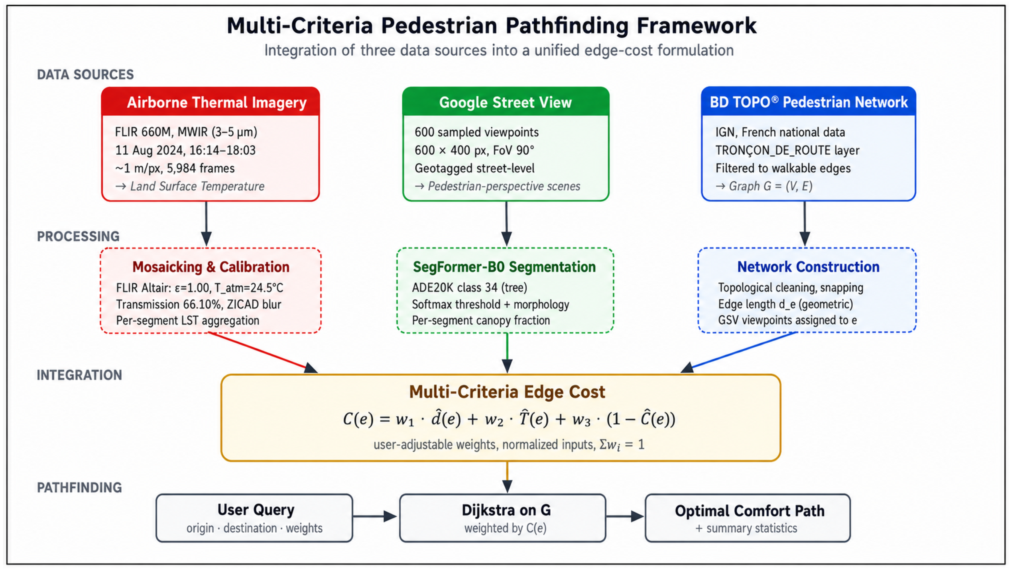
3.1. Overview of the Framework
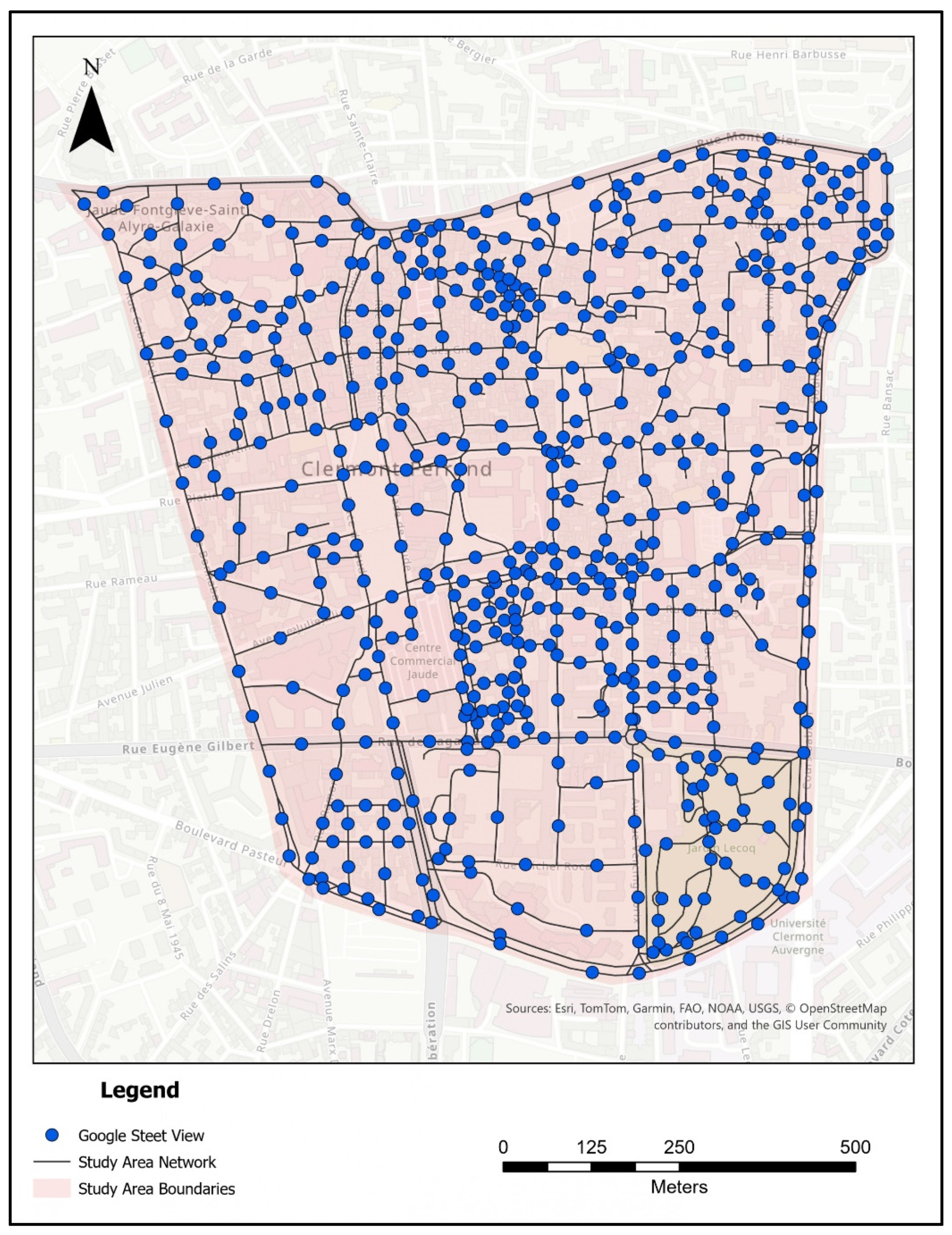
3.2. Study Area
3.3. Data Sources
3.3.1. Pedestrian Street Network
3.3.2. Google Street View Imagery
3.3.3. Airborne Thermal Imagery
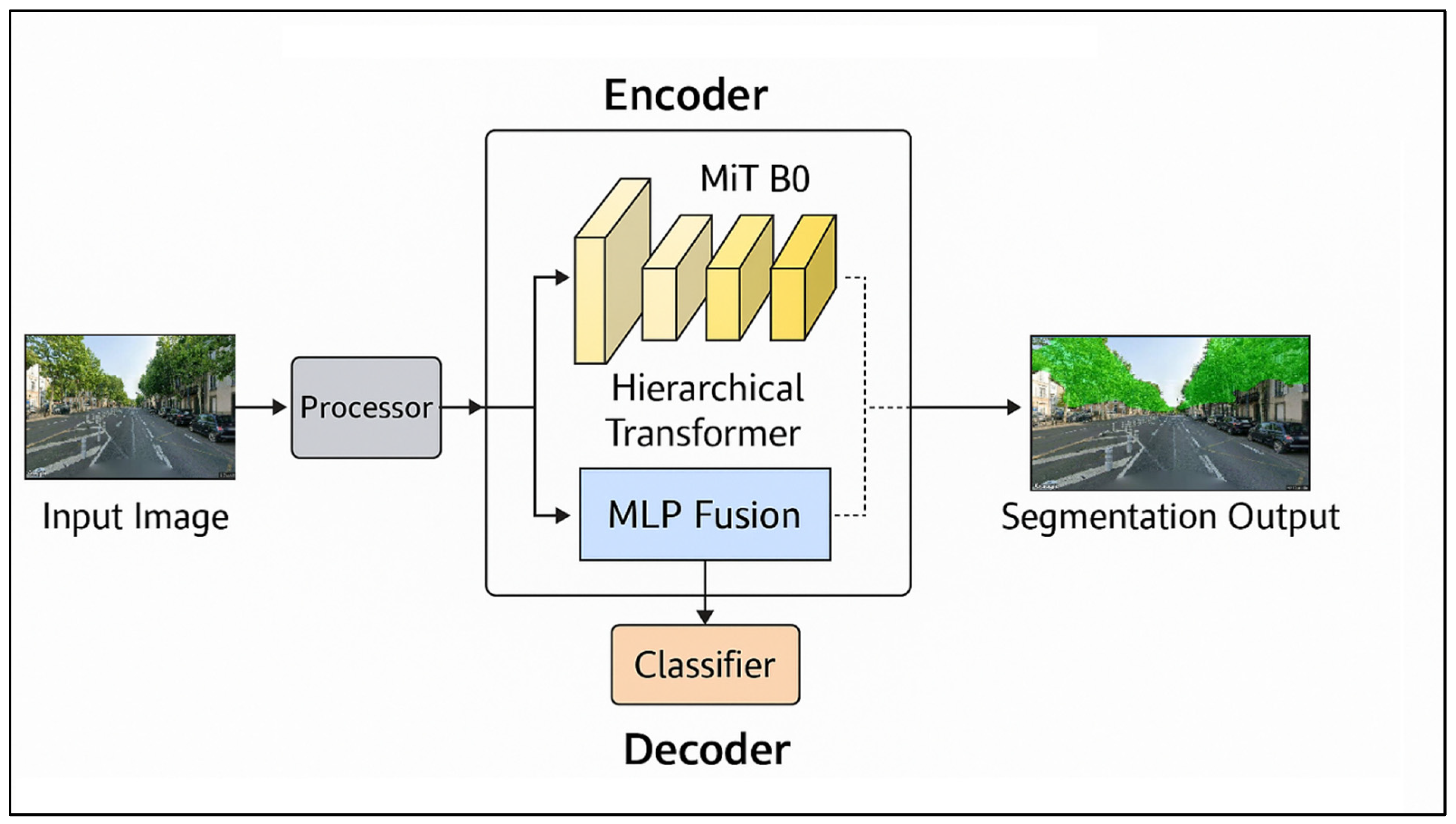
3.4. Tree Canopy Extraction from Street-Level Imagery
3.5. Aggregation of LST onto the Pedestrian Network
3.6. Multi-Criteria Edge-Cost Formulation
3.7. Pathfinding and User Interaction
3.8. Implementation and Reproducibility
4. Results
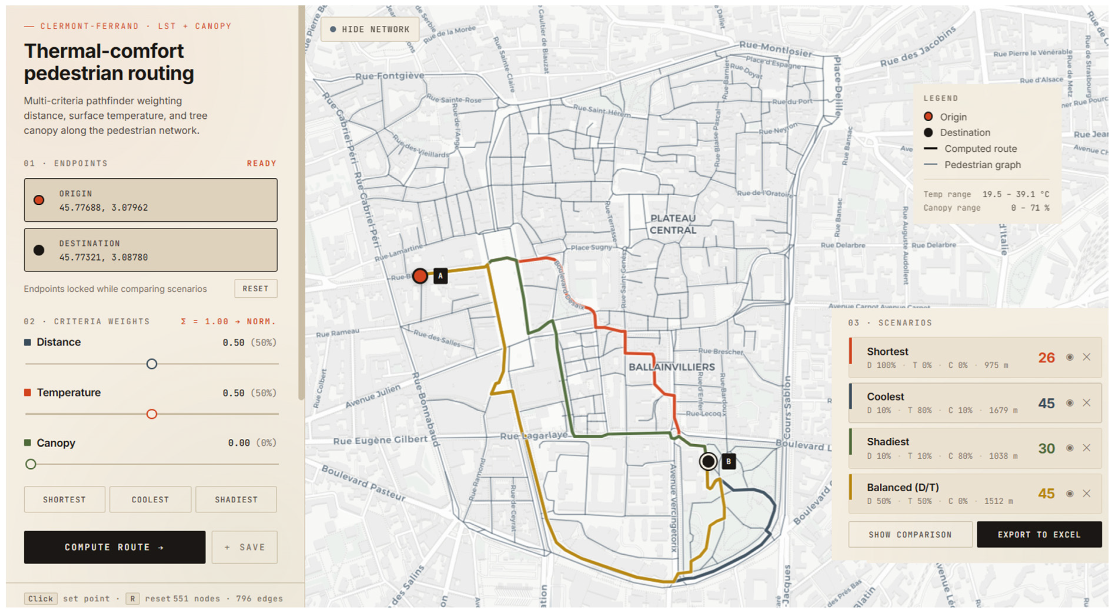
4.1. The Integrated Tool: Implementation and Network Coverage
4.2. Route Comparison Results for the OD Scenario
5. Discussion
5.1. What the Tool Delivers Methodologically: Methodological Contribution
5.2. Toward User-Comfort Pathfinding: Introducing a Generic Concept
- (i)
- Mental satisfaction and restfulness: the cognitive and affective dimension, related to the perceived pleasantness, safety, and esthetic quality of the environment a pedestrian moves through;
- (ii)
- Physical refreshment and material well-being: the bodily dimension, encompassing thermal comfort, ergonomic walking conditions, air quality, and other factors that affect the body directly during the journey;
- (iii)
- The conditions which produce or promote the state of being comfortable: the environmental dimension, recognizing that comfort is not only a sensation but also a property of the surrounding urban form: the presence of shade, the geometry of sidewalks, the absence of noise, or the availability of resting points along the route.
5.3. Scalability of the Framework
5.4. Limitations and Avenues for Future Work
6. Conclusions
Supplementary Materials
Author Contributions
Funding
Data Availability Statement
Acknowledgments
Conflicts of Interest
References
- Zhao, H.; Xu, G.; Shi, Y.; Zhai, Y.; Zhao, L.; Brown, R.D. Evaluation of Pedestrian Thermal Comfort from a Whole-Trip Perspective: An Outdoor Empirical Study. Sustain. Cities Soc. 2024, 115, 105872. [Google Scholar] [CrossRef]
- Taher, H.; Elsharkawy, H.; Rashed, H.F. Urban Green Systems for Improving Pedestrian Thermal Comfort and Walkability in Future Climate Scenarios in London. Buildings 2024, 14, 651. [Google Scholar] [CrossRef]
- Krüger, E.L.; Costa, T. Interferences of Urban Form on Human Thermal Perception. Sci. Total Environ. 2019, 653, 1067–1076. [Google Scholar] [CrossRef] [PubMed]
- Lu, Y.; Sarkar, C.; Xiao, Y. The Effect of Street-Level Greenery on Walking Behavior: Evidence from Hong Kong. Soc. Sci. Med. 2018, 208, 41–49. [Google Scholar] [CrossRef] [PubMed]
- Li, X.; Zhang, C.; Li, W.; Ricard, R.; Meng, Q.; Zhang, W. Assessing Street-Level Urban Greenery Using Google Street View and a Modified Green View Index. Urban For. Urban Green. 2015, 14, 675–685. [Google Scholar] [CrossRef]
- Basu, R.; Colaninno, N.; Alhassan, A.; Sevtsuk, A. Hot and Bothered: Exploring the Effect of Heat on Pedestrian Route Choice Behavior and Accessibility. Cities 2024, 155, 105435. [Google Scholar] [CrossRef]
- Melnikov, V.R.; Christopoulos, G.I.; Krzhizhanovskaya, V.V.; Lees, M.H.; Sloot, P.M.A. Behavioural Thermal Regulation Explains Pedestrian Path Choices in Hot Urban Environments. Sci. Rep. 2022, 12, 2441. [Google Scholar] [CrossRef] [PubMed]
- Hua, J.; Cai, M.; Shi, Y.; Ren, C.; Xie, J.; Chung, L.C.H.; Lu, Y.; Chen, L.; Yu, Z.; Webster, C. Investigating Pedestrian-Level Greenery in Urban Forms in a High-Density City for Urban Planning. Sustain. Cities Soc. 2022, 80, 103755. [Google Scholar] [CrossRef]
- Zhu, J.; Huang, Y.; Cao, Z.; Zhang, Y.; Ding, Y.; Du, J. Evaluating Urban Greenery Through the Front-Facing Street View Imagery: Insights from a Nanjing Case Study. ISPRS Int. J. Geo-Inf. 2025, 14, 287. [Google Scholar] [CrossRef]
- Buo, I.; Khan, W.H.; Crabtree, E.; Emmott, F.; Hariyani, D.; Middel, A. Cool Routes: Real-Time Human Thermal Exposure Routing. Build. Environ. 2026, 298, 114622. [Google Scholar] [CrossRef]
- Anguelov, D.; Dulong, C.; Filip, D.; Frueh, C.; Lafon, S.; Lyon, R.; Ogale, A.; Vincent, L.; Weaver, J. Google Street View: Capturing the World at Street Level. Computer 2010, 43, 32–38. [Google Scholar] [CrossRef]
- Han, X.; Wang, L.; Seo, S.H.; He, J.; Jung, T. Measuring Perceived Psychological Stress in Urban Built Environments Using Google Street View and Deep Learning. Front. Public Health 2022, 10, 891736. [Google Scholar] [CrossRef] [PubMed]
- Li, X.; Ratti, C.; Seiferling, I. Mapping Urban Landscapes Along Streets Using Google Street View. In Proceedings of the Advances in Cartography and GIScience; Peterson, M.P., Ed.; Springer International Publishing: Cham, Switzerland, 2017; pp. 341–356. [Google Scholar]
- European Commission. Active Mobility: Walking and Cycling—Mobility and Transport. Available online: https://transport.ec.europa.eu/transport-themes/urban-transport/active-mobility-walking-and-cycling_en (accessed on 10 May 2026).
- Abuwaer, N.; Ullah, S.; Vinodhkumar, B.; Al-Ghamdi, S.G. Walkability under the Influence of Extreme Temperatures: The Impact of Climate Change on Outdoor Thermal Discomfort in Saudi Arabia. City Environ. Interact. 2025, 28, 100241. [Google Scholar] [CrossRef]
- Voogt, J.A.; Oke, T.R. Thermal Remote Sensing of Urban Climates. Remote Sens. Environ. 2003, 86, 370–384. [Google Scholar] [CrossRef]
- Weng, Q. Thermal Infrared Remote Sensing for Urban Climate and Environmental Studies: Methods, Applications, and Trends. ISPRS J. Photogramm. Remote Sens. 2009, 64, 335–344. [Google Scholar] [CrossRef]
- Goldblatt, R.; Addas, A.; Crull, D.; Maghrabi, A.; Levin, G.G.; Rubinyi, S. Remotely Sensed Derived Land Surface Temperature (LST) as a Proxy for Air Temperature and Thermal Comfort at a Small Geographical Scale. Land 2021, 10, 410. [Google Scholar] [CrossRef]
- Scolio, M.; Kremer, P.; Zhang, Y.; Shakya, K.M. Spatial-Temporal Modeling of the Relationship between Surface Temperature and Air Temperature in Metropolitan Urban Systems. Urban Clim. 2024, 55, 101921. [Google Scholar] [CrossRef]
- Sun, T.; Sun, R.; Chen, L. The Trend Inconsistency between Land Surface Temperature and Near Surface Air Temperature in Assessing Urban Heat Island Effects. Remote Sens. 2020, 12, 1271. [Google Scholar] [CrossRef]
- Urban, J.; Pikl, M.; Zemek, F.; Novotný, J. Using Google Street View Photographs to Assess Long-Term Outdoor Thermal Perception and Thermal Comfort in the Urban Environment during Heatwaves. Front. Environ. Sci. 2022, 10, 878341. [Google Scholar] [CrossRef]
- Li, X.; Ratti, C.; Seiferling, I. Quantifying the Shade Provision of Street Trees in Urban Landscape: A Case Study in Boston, USA, Using Google Street View. Landsc. Urban Plan. 2018, 169, 81–91. [Google Scholar] [CrossRef]
- Cai, B.Y.; Li, X.; Seiferling, I.; Ratti, C. Treepedia 2.0: Applying Deep Learning for Large-Scale Quantification of Urban Tree Cover. arXiv 2018. [Google Scholar] [CrossRef]
- Biljecki, F.; Zhao, T.; Liang, X.; Hou, Y. Sensitivity of Measuring the Urban Form and Greenery Using Street-Level Imagery: A Comparative Study of Approaches and Visual Perspectives. Int. J. Appl. Earth Obs. Geoinf. 2023, 122, 103385. [Google Scholar] [CrossRef]
- Transform Transport. Exploring Transport Security Perception with NLP and Geo-Social Media. 2025. Available online: https://transformtransport.org/research/exploring-transport-security-perception-with-nlp-and-geo-social-media/ (accessed on 10 May 2026).
- Xie, E.; Wang, W.; Yu, Z.; Anandkumar, A.; Alvarez, J.M.; Luo, P. SegFormer: Simple and Efficient Design for Semantic Segmentation with Transformers. arXiv 2021. [Google Scholar] [CrossRef]
- Quercia, D.; Schifanella, R.; Aiello, L.M. The Shortest Path to Happiness: Recommending Beautiful, Quiet, and Happy Routes in the City. In Proceedings of the 25th ACM Conference on Hypertext and Social Media, Santiago, Chile, 1–4 September 2014. [Google Scholar]
- Bolívar-Anillo, H.J.; Benites, S.V.; Almeida, G.R.; Llanos, S.d.J.O.; Taba-Charris, V.; Acuña-Ruiz, K.A.; Vargas, B.S.R.; Aguillón, P.F.C.; Moreno, H.S.; Iglesias-Navas, M.A.; et al. Addressing Increased Temperatures in Cities: Determination of Pedestrian Routes with Thermal Comfort in Barranquilla, Colombia. Sustainability 2025, 17, 5211. [Google Scholar] [CrossRef]
- Al Shammas, T.; Gullón, P.; Klein, O.; Escobar, F. Development of a GIS-Based Walking Route Planner with Integrated Comfort Walkability Parameters. Comput. Environ. Urban Syst. 2023, 103, 101981. [Google Scholar] [CrossRef]
- Neset, T.-S.; Navarra, C.; Graça, M.; Opach, T.; Wilk, J.; Wallin, P.; Andersson, L.; Santos Cruz, S.; Monteiro, A.; Rød, J.K. Navigating Urban Heat—Assessing the Potential of a Pedestrian Routing Tool. Urban Clim. 2022, 46, 101333. [Google Scholar] [CrossRef]
- Ma, X.; Zeng, T.; de Dear, R.; Xie, Y.; Yuan, C.; Lu, S. Active Route Choice to Minimize Pedestrian Thermal Discomfort in a High-Density Subtropical City. Sustain. Cities Soc. 2025, 131, 106697. [Google Scholar] [CrossRef]
- Wen, J.; Abuhani, D.A.; Mazzarello, M.; Duarte, F.; Norford, L.; Xu, R.; Wong, N.H.; Ratti, C. Walking Smart in the Heat: A Dynamic Shade-Oriented Pathfinding Approach to Enhance Pedestrian Comfort in Arid Cities. Comput. Environ. Urban Syst. 2025, 122, 102337. [Google Scholar] [CrossRef]
- Brito, M.; Martins, B.; Santos, C.; Medeiros, I.; Araujo, F.; Seruffo, M.; Oliveira, H.M.; Cerqueira, E.; Rosário, D. Personalized Experience-Aware Multi-Criteria Route Selection for Smart Mobility. In Proceedings of the 41st Brazilian Symposium on Computer Networks and Distributed Systems (SBRC 2023), Brasília, Brazil, 22–26 May 2023. [Google Scholar]
- National Institute of Geographic and Forest Information (IGN) IGN. BD TOPO. Available online: https://cartes.gouv.fr/rechercher-une-donnee/dataset/IGNF_BD-TOPO?redirected_from=geoservices.ign.fr (accessed on 10 May 2026).
- Extreme Weather Watch. Clermont-Ferrand Weather Records. Available online: https://www.extremeweatherwatch.com/cities/clermont-ferrand (accessed on 10 May 2026).
- French Public Health Agency. Public Health Bulletin on the Heat Wave in Auvergne-Rhône-Alpes: Summer 2022 Report. Available online: https://www.santepubliquefrance.fr/en/regions-et-territoires/auvergne-rhone-alpes/regional-bulletin/public-health-bulletin-heat-wave-auvergne-rhone-alpes-summer-2022-report (accessed on 10 May 2026).
- Clermont Auvergne Metropolis. Thermographie 1 m—Clermont-Ferrand—Été 2024. Available online: https://www.data.gouv.fr/datasets/thermographie-1-m-clermont-ferrand-ete-2024 (accessed on 10 May 2026).
- Aerodata France. Clermont_2024_Thermo_Rapport_Mission (3).Pdf. Available online: https://drive.uca.fr/lib/7d6ced64-79c9-47ff-bed7-49887dfa6eea/file/Clermont_2024_thermo_rapport_mission%20(3).pdf (accessed on 10 May 2026).
- Zhou, B.; Zhao, H.; Puig, X.; Xiao, T.; Fidler, S.; Barriuso, A.; Torralba, A. Semantic Understanding of Scenes through the ADE20K Dataset. arXiv 2016. [Google Scholar] [CrossRef]
- Gangwisch, M.; Fröhlich, D.; Christen, A.; Matzarakis, A. Geometrical Assessment of Sunlit and Shaded Area of Urban Trees Based on Aligned Orthographic Views. Atmosphere 2021, 12, 968. [Google Scholar] [CrossRef]
- Klemm, W.; Heusinkveld, B.G.; Lenzholzer, S.; van Hove, B. Street Greenery and Its Physical and Psychological Impact on Thermal Comfort. Landsc. Urban Plan. 2015, 138, 87–98. [Google Scholar] [CrossRef]
- Tong, Y.; Bode, N.W.F. The Principles of Pedestrian Route Choice. J. R. Soc. Interface 2022, 19, 20220061. [Google Scholar] [CrossRef] [PubMed]
- Shah, U.; Wang, J. A Personalised Pedestrian Navigation System (Short Paper). In Proceedings of the 12th International Conference on Geographic Information Science (GIScience 2023); Schloss Dagstuhl—Leibniz-Zentrum für Informatik: Dagstuhl, Germany, 2023; Volume 277, pp. 67:1–67:6. [Google Scholar] [CrossRef]
- Oxford English Dictionary. Comfort. Available online: https://www.oed.com/dictionary/comfort_n (accessed on 10 February 2026).
- Mushkani, R.; Koseki, S. Street Review: A Participatory AI-Based Framework for Assessing Streetscape Inclusivity. Cities 2026, 170, 106602. [Google Scholar] [CrossRef]
- Liang, X.; Chang, J.H.; Gao, S.; Zhao, T.; Biljecki, F. Evaluating Human Perception of Building Exteriors Using Street View Imagery. Build. Environ. 2024, 263, 111875. [Google Scholar] [CrossRef]





| Study | Routing Variables | Data Source | Spatial Application Context | Routing Output | Gap Relative to This Study |
|---|---|---|---|---|---|
| [28] | PET | Thermal comfort modeling | Historic urban neighborhood | Thermal comfort routing | Prototype-oriented application; no street viewing-based image analysis |
| [29] | Solar exposure + greenery | GIS layers + expert weighting | City-wide pedestrian network | Comfort-aware route planner | Derived indicators, not direct observations |
| [30] | Urban heat exposure | Urban heat maps | City-wide navigation system | Heat-aware navigation | Limited street-level shade representation |
| [31] | PET + vegetation effects | ENVI-met simulations | High-density urban district | Thermal route optimization | Simulation-dependent workflow |
| [32] | Solar radiation + shade | Shadow/radiation modeling | Arid urban district | Dynamic shade-aware routing | Modeled shade conditions |
| [10] | MRT-based exposure | Thermal comfort modeling | City-scale routing platform | Real-time thermal routing | Model-generated thermal conditions |
| This study | LST + canopy + distance | Airborne thermography + GSV segmentation | Historic-city-center pedestrian network | Multi-criteria routing tool | Future behavioral validation |
| Scenario | Weights (D/T/C) | Length (m) | Avg. LST (°C) | Avg. Canopy (%) | Comfort | Segments |
|---|---|---|---|---|---|---|
| Shortest | 1.0/0/0 | 975 | 30.95 | 6.5 | 25.5 | 26 |
| Shadiest | 0.1/0.1/0.8 | 1038 | 30.19 | 9.8 | 29.7 | 18 |
| Coolest | 0.1/0.8/0.1 | 1679 | 26.08 | 16.5 | 45.0 | 21 |
| Balanced (D/T) | 0.5/0.5/0 | 1512 | 26.11 | 16.0 | 44.5 | 21 |
| Explanatory Example 1 | Weights (D/T/C) | Length (m) | Avg. LST (°C) | Avg. Canopy (%) | Comfort |
|---|---|---|---|---|---|
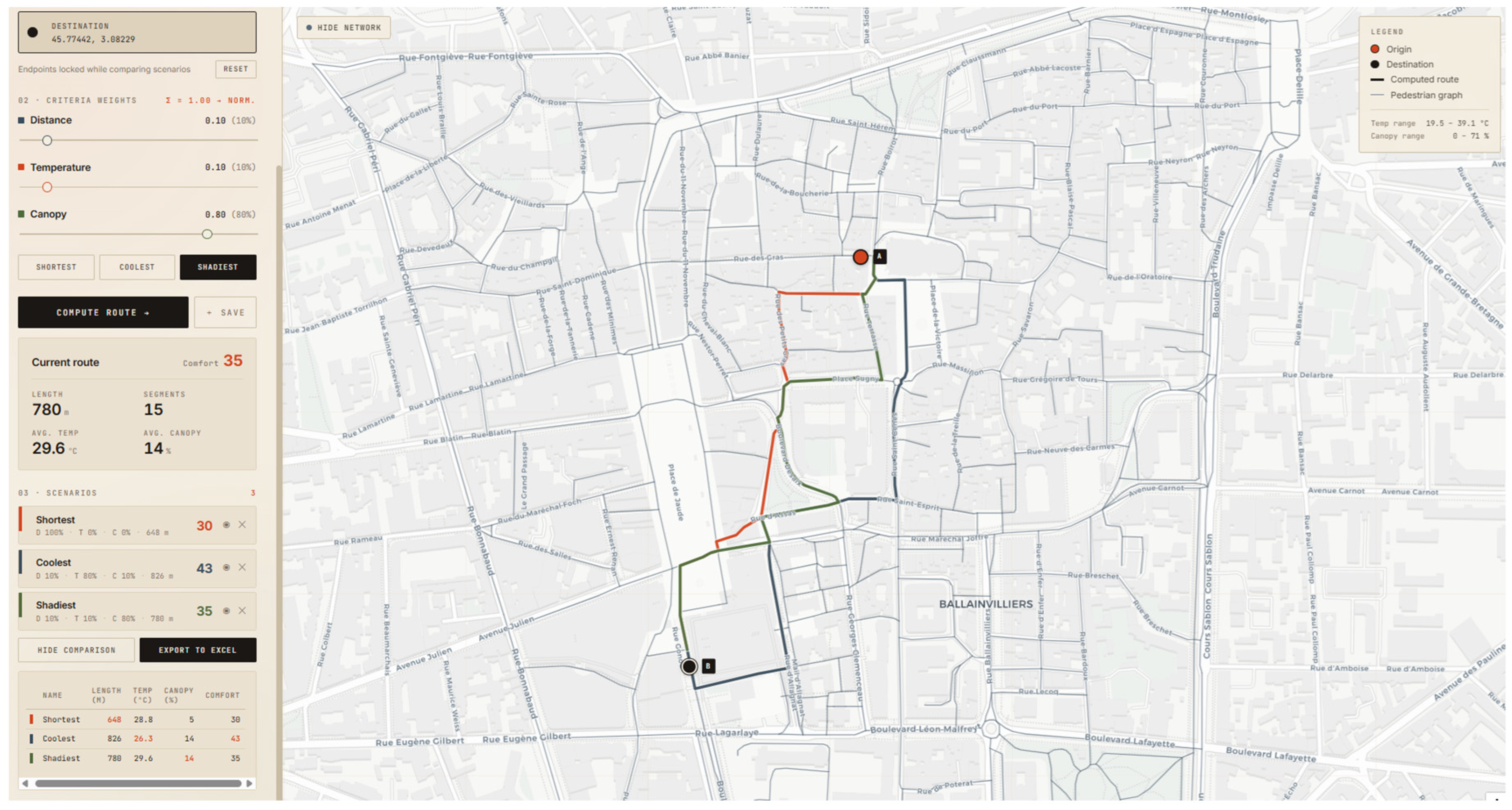
| Shortest | 1.0/0/0 | 648 | 28.8 | 5 | 30 |
| Shadiest | 0.1/0.8/0.1 | 826 | 26.3 | 14 | 43 |
| Coolest | 0.1/0.1/0.8 | 780 | 29.6 | 14 | 35 |
| Explanatory Example 2 | Weights (D/T/C) | Length (m) | Avg. LST (°C) | Avg. Canopy (%) | Comfort |
|---|---|---|---|---|---|
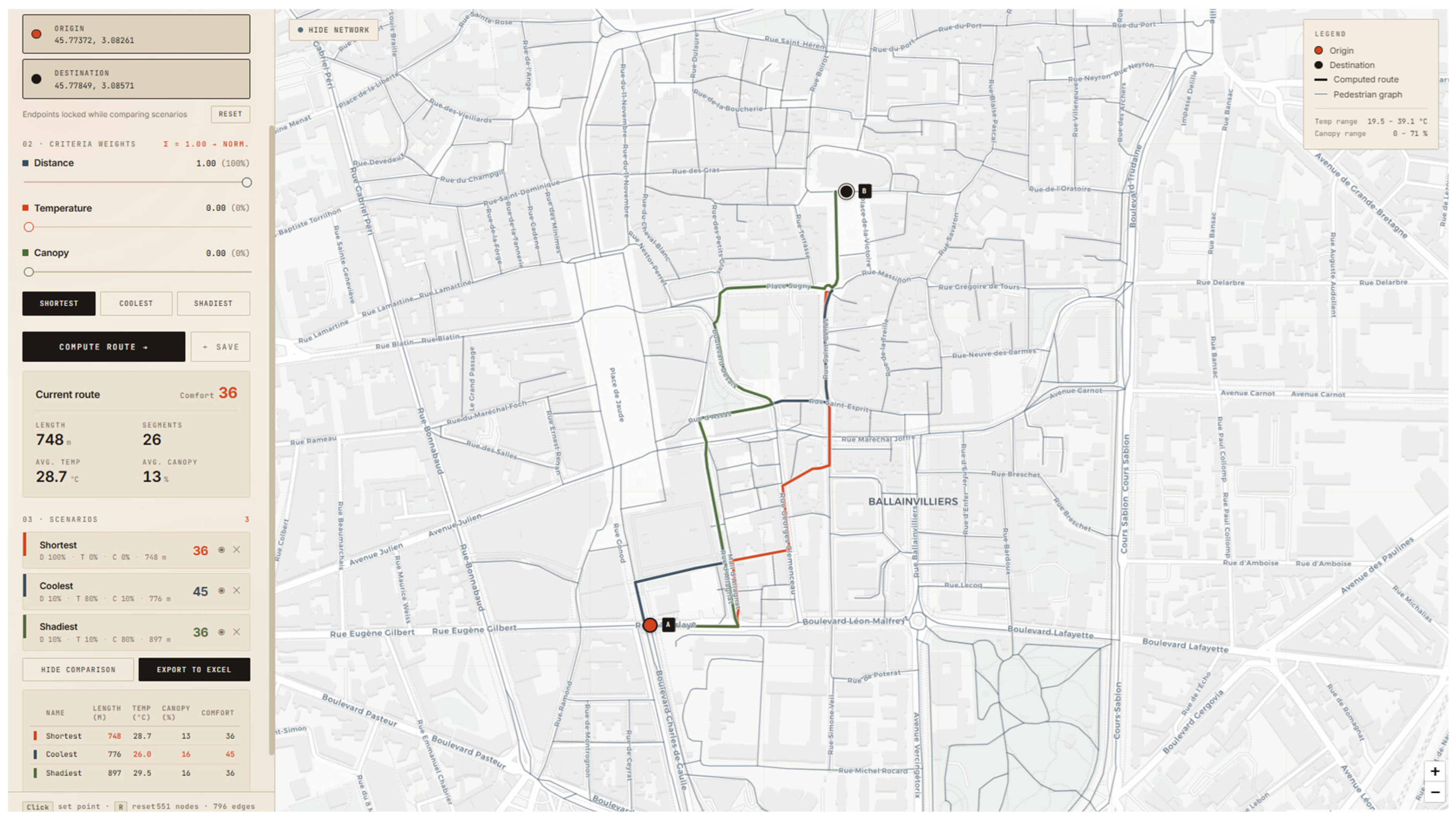
| Shortest | 1.0/0/0 | 748 | 28.7 | 13 | 36 |
| Coolest | 0.1/0.8/0.1 | 776 | 26.0 | 16 | 45 |
| Shadiest | 0.1/0.1/0.8 | 897 | 29.5 | 16 | 36 |
Disclaimer/Publisher’s Note: The statements, opinions and data contained in all publications are solely those of the individual author(s) and contributor(s) and not of MDPI and/or the editor(s). MDPI and/or the editor(s) disclaim responsibility for any injury to people or property resulting from any ideas, methods, instructions or products referred to in the content. |
© 2026 by the authors. Published by MDPI on behalf of the International Society for Photogrammetry and Remote Sensing. Licensee MDPI, Basel, Switzerland. This article is an open access article distributed under the terms and conditions of the Creative Commons Attribution (CC BY) license.
Share and Cite
Mansour, S.; Itair, M.; El Meouche, R.; Talon, A.; Breul, P. User-Comfort Pathfinding: Integrating Thermal Imagery and Street-Level Vegetation Analysis into Multi-Criteria Pedestrian Routing. ISPRS Int. J. Geo-Inf. 2026, 15, 313. https://doi.org/10.3390/ijgi15070313
Mansour S, Itair M, El Meouche R, Talon A, Breul P. User-Comfort Pathfinding: Integrating Thermal Imagery and Street-Level Vegetation Analysis into Multi-Criteria Pedestrian Routing. ISPRS International Journal of Geo-Information. 2026; 15(7):313. https://doi.org/10.3390/ijgi15070313
Chicago/Turabian StyleMansour, Saffa, Mohammed Itair, Rani El Meouche, Aurelie Talon, and Pierre Breul. 2026. "User-Comfort Pathfinding: Integrating Thermal Imagery and Street-Level Vegetation Analysis into Multi-Criteria Pedestrian Routing" ISPRS International Journal of Geo-Information 15, no. 7: 313. https://doi.org/10.3390/ijgi15070313
APA StyleMansour, S., Itair, M., El Meouche, R., Talon, A., & Breul, P. (2026). User-Comfort Pathfinding: Integrating Thermal Imagery and Street-Level Vegetation Analysis into Multi-Criteria Pedestrian Routing. ISPRS International Journal of Geo-Information, 15(7), 313. https://doi.org/10.3390/ijgi15070313