Low-Cost Deep Learning for Building Detection with Application to Informal Urban Planning


Abstract
1. Introduction
- The evaluation of deep learning models (U-Net, ResNet, FCN) for building detection across diverse urban morphologies, using only RGB imagery.
- The introduction and use of SJM, a new annotated dataset of a low-planning urban area, to assess transferability.
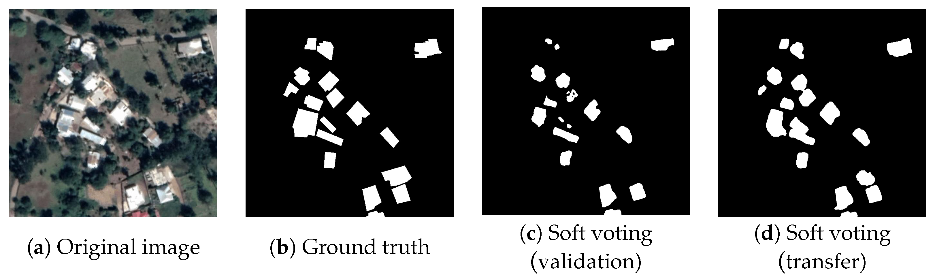
- The proposal of a soft-voting ensemble method, improving over state-of-the-art results, with an up to 0.9665.
- RQ1: How can U-Net-based architectures be optimized and tuned to generalize across heterogeneous urban contexts while maintaining high detection accuracy?
- RQ2: To what extent RGB-only input datasets suffice in building detection, traditionally reliant on multi-modal or higher-dimensional data sources (infrared, laser)?
- RQ3: Can pre-trained models adapt to the unique characteristics of underrepresented regions with poor urban planning, without additional data annotations?
2. Problem Definition and Literature Review
2.1. The Automatic Building Detection Problem
2.2. Related Work
- This study expands on the use of U-Net architectures for building detection by introducing and benchmarking hybrid U-Net–ResNet and U-Net–ResNeXt models across multiple standard datasets, showcasing their robustness and versatility.
- Exhaustive parameter tuning is performed on the proposed models to achieve the best possible results for building detection.
- An ensemble approach is proposed to address challenges like closely spaced buildings, providing effective solutions without adding computational complexity, unlike methods using dual encoders from the literature.
- Only RGB imagery is used, enhancing the applicability of the models in real-world scenarios where specialized data (infrared imagery, GIS datasets) may not be available.
- The analyzed models demonstrate strong generalization by applying pre-trained architectures on global datasets to diverse scenarios, including the underrepresented San José de las Matas dataset, overcoming the limitations of sparse-label approaches.
3. Methodology
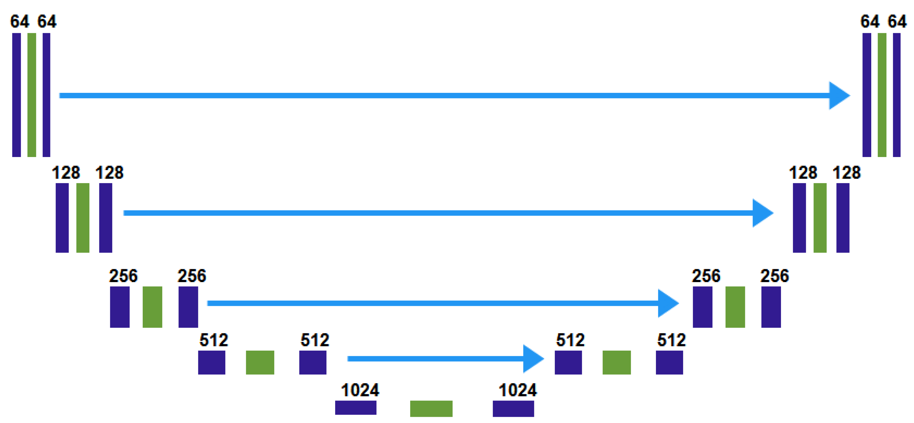
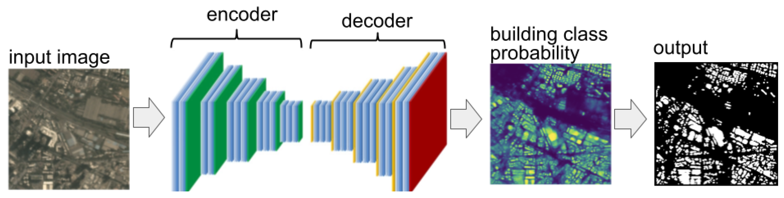
3.1. DNNs Considered in the Study
3.2. Problem Instances
3.2.1. Massachusetts Buildings Dataset (MBD)
3.2.2. INRIA Aerial Image Labeling Dataset (IAD)
3.2.3. WHU Building Dataset–Christchurch (WHU)
3.2.4. Satellite Dataset II East Asia (EAII)
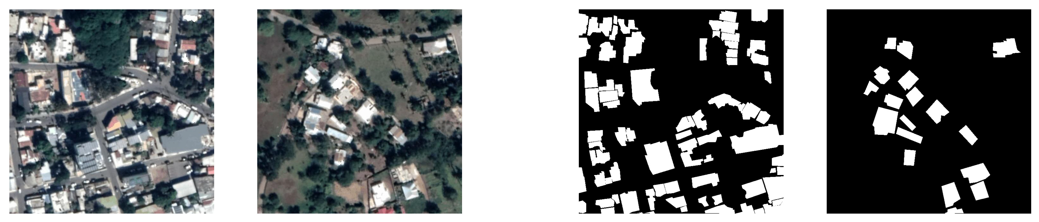
3.2.5. San José de las Matas (SJM)
3.3. Methodological Stages
3.4. Approaches
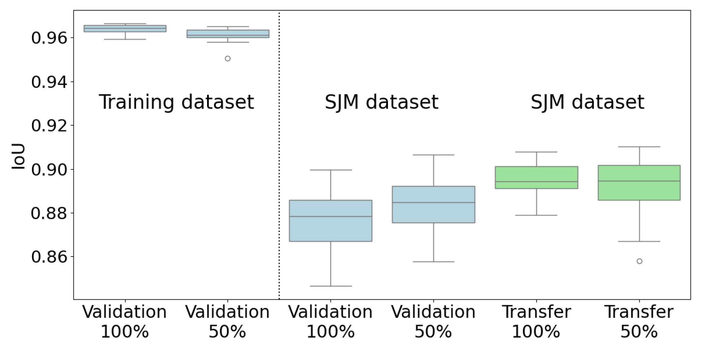
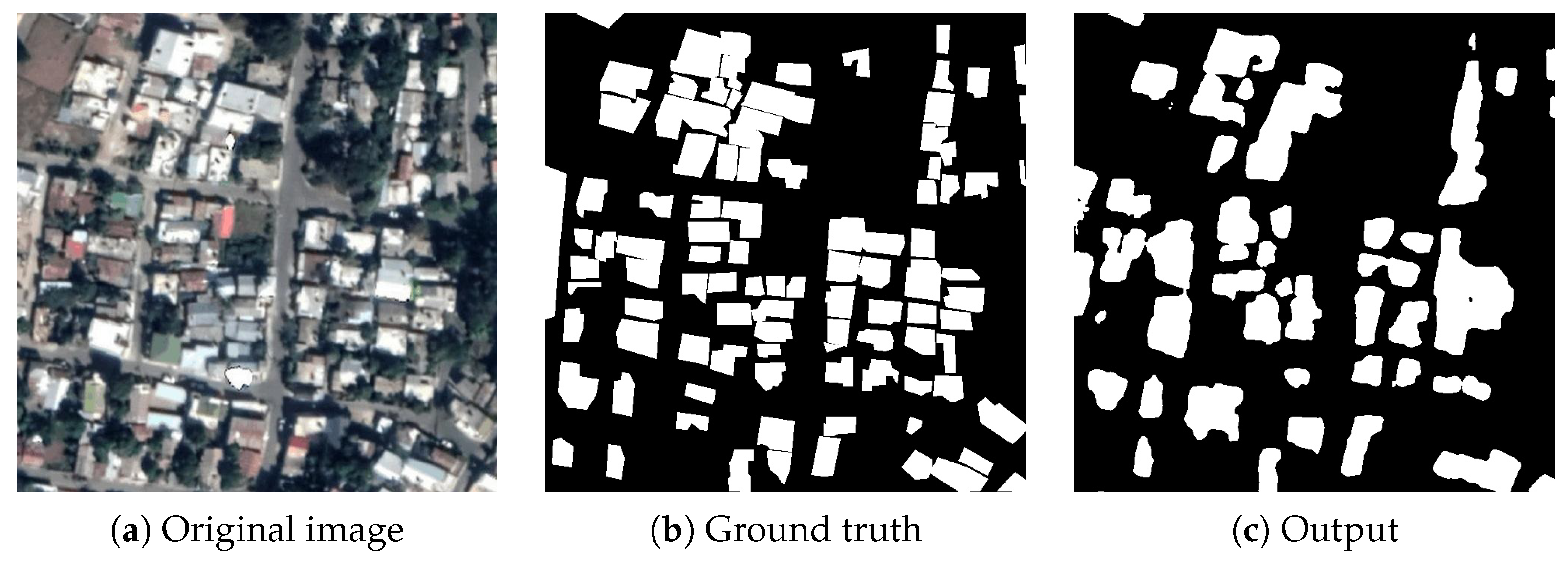
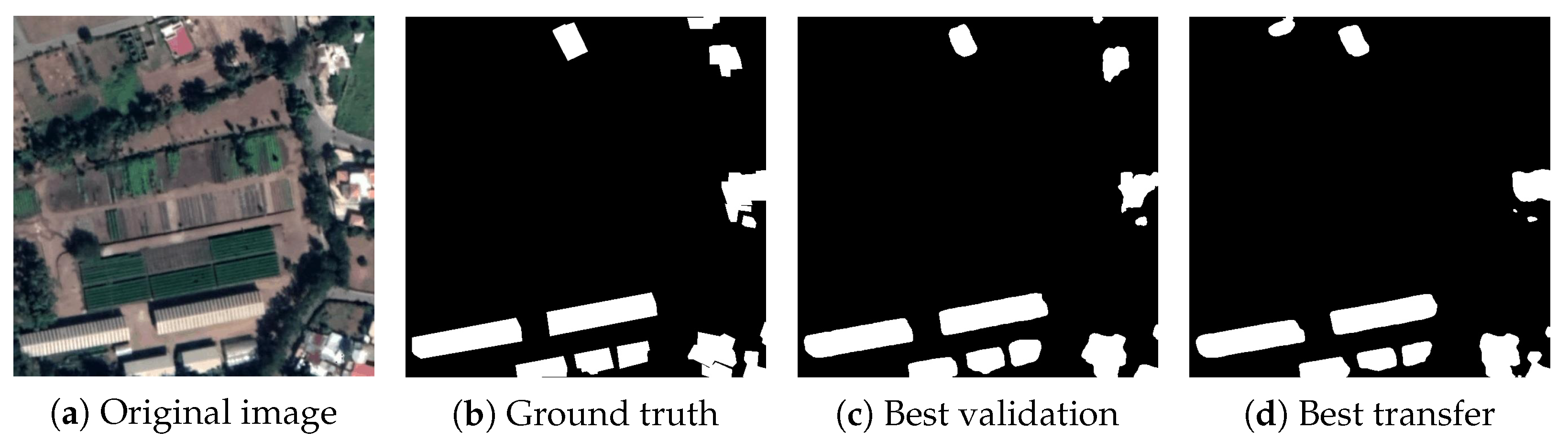
- Validation: At each step, the resulting from each model was measured with the test set of the dataset that the model was trained on.
- Transfer: At each step, the resulting from each model was measured with the SJM dataset. In each stage, the models were trained with the IAD, WHU, MBD, and EAII datasets, but the taken into account for selecting the best model was the one obtained when evaluating over the SJM dataset.
4. Experimental Setup
4.1. Evaluated DNNs Architectures
4.2. Data Augmentation
4.3. Performance Metric
4.4. Calibration Methods
4.5. Development and Execution Platform
5. Experimental Evaluation and Discussion
5.1. Stage 1: Selection of the Best Architectures
5.2. Stage 2: Resizing MBD and IAD Datasets
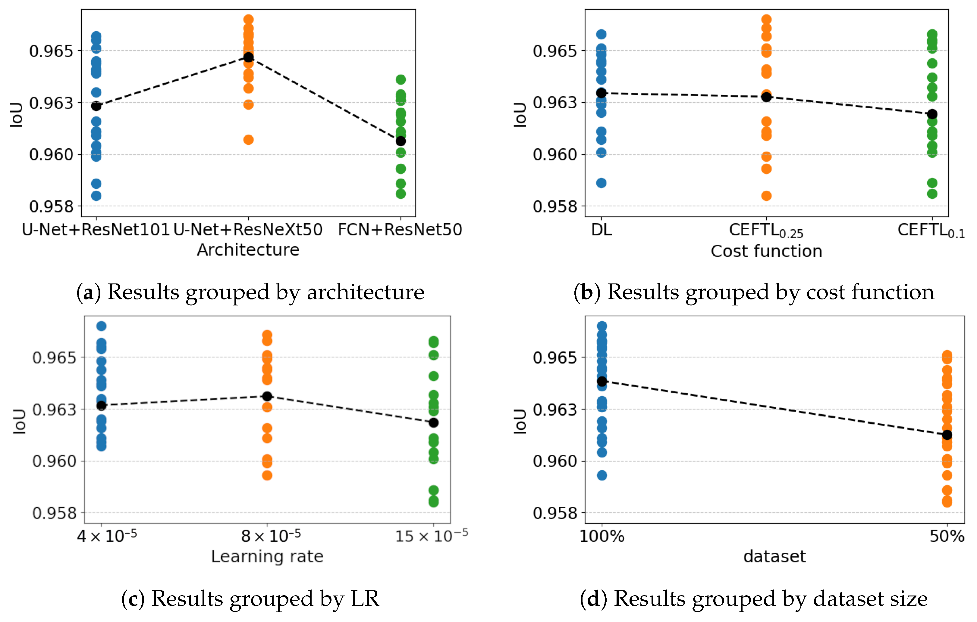
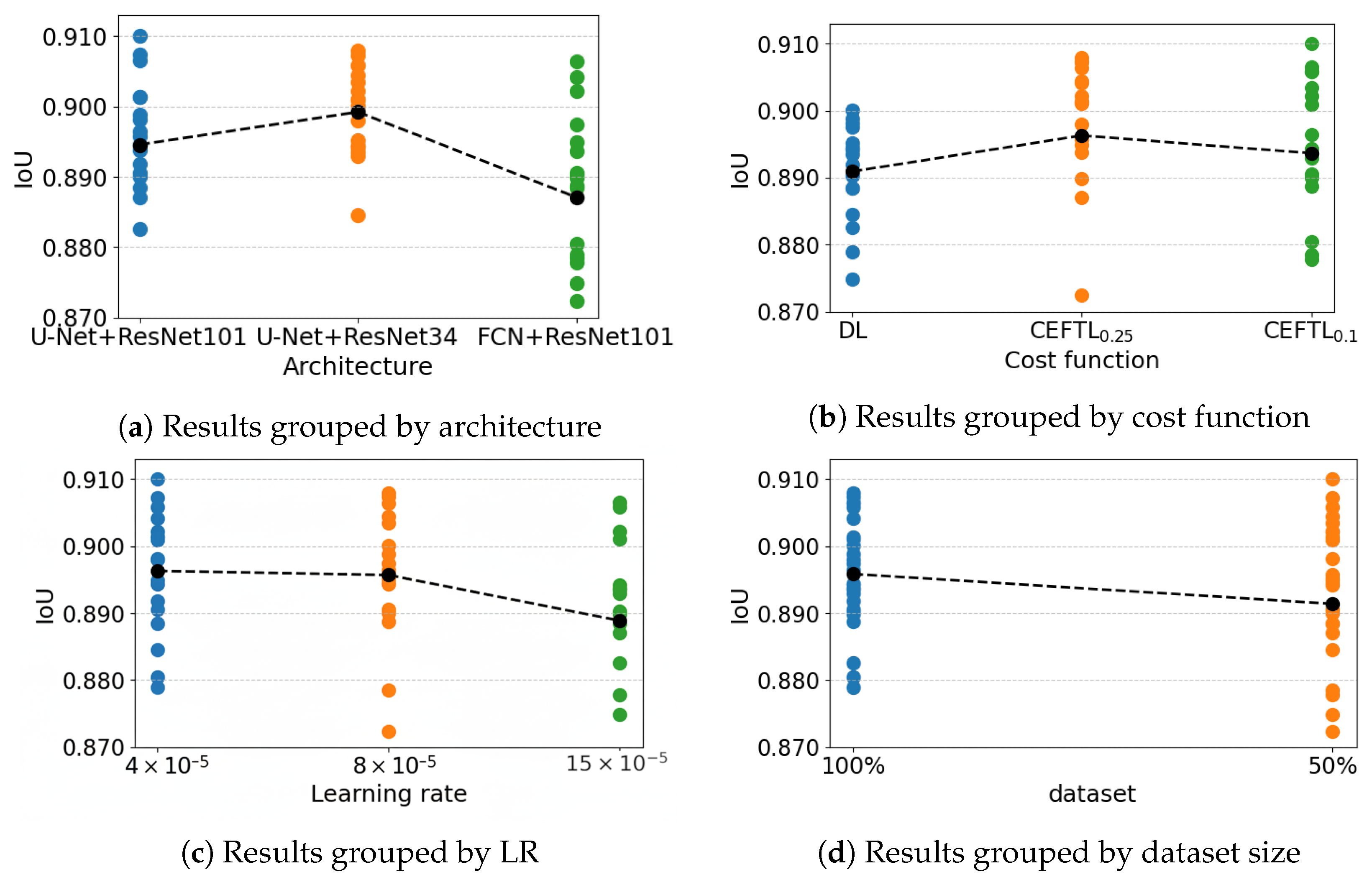
5.3. Stage 3: Hyperparameters for Models Trained with the Unified Dataset
5.3.1. Validation
5.3.2. Transfer
5.3.3. Comparative Analysis: Validation vs. Transfer
5.4. Stage 4—Models Calibration
5.5. Stage 5—Model Voting
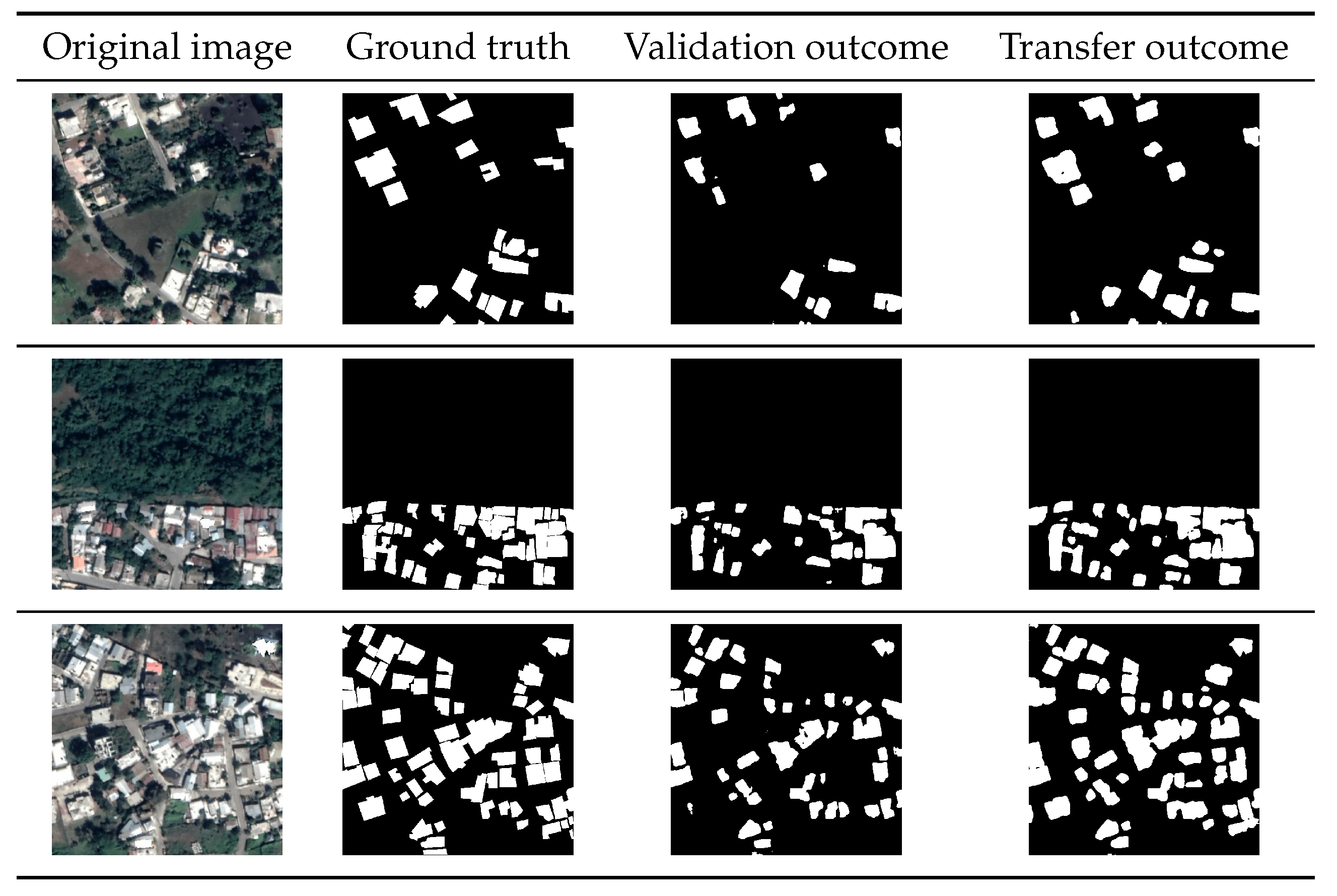
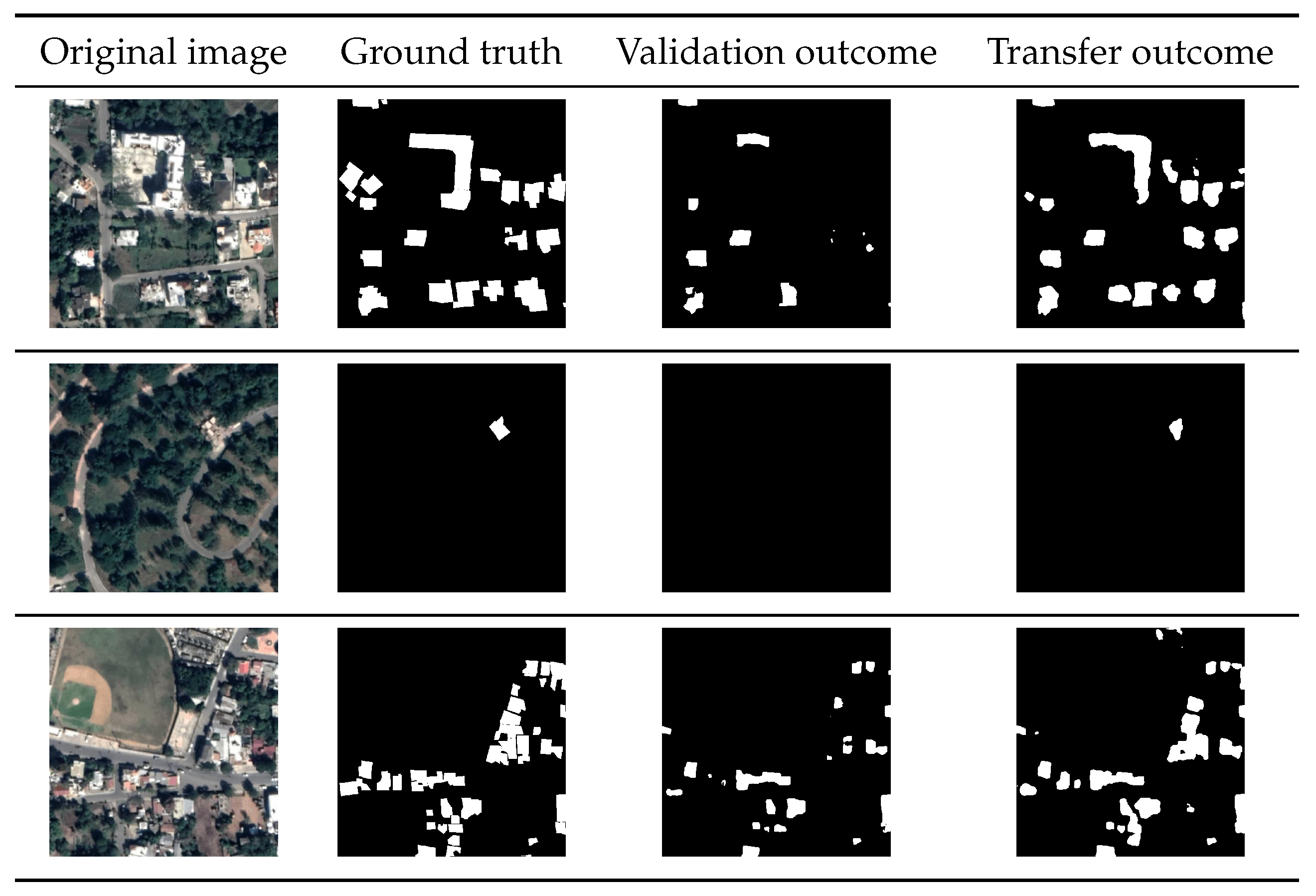
5.6. Examples of Building Detection
5.6.1. Validation
5.6.2. Transfer
5.7. Comparison with Existing Methods for Building Detection
5.7.1. Baseline Methods and Datasets
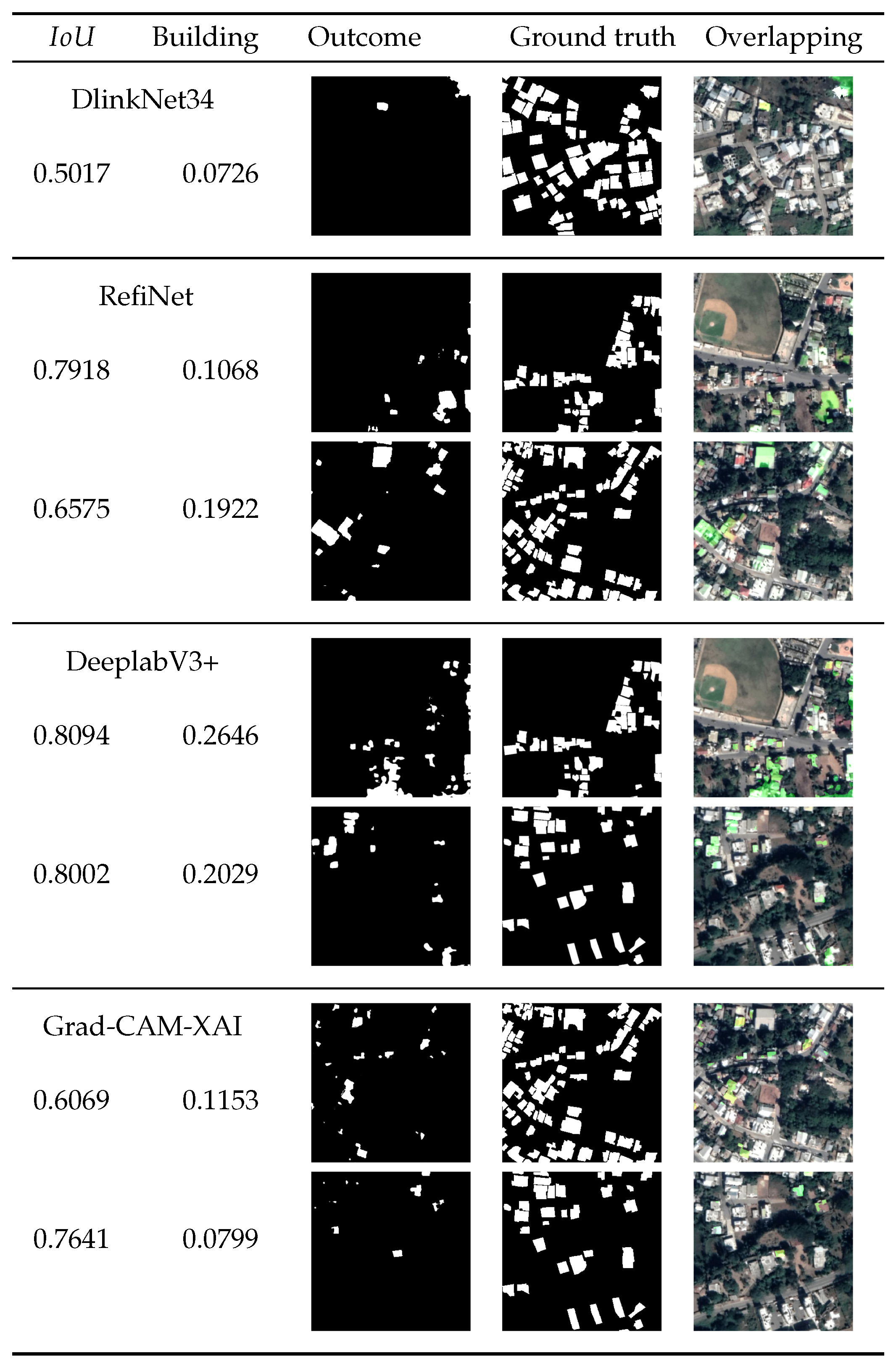
- DlinkNet34 [30], an encoder–decoder DNN including dilated convolution and a pre-trained encoder (Linknet).
- RefiNet [30], a multi-scale refinement DNN that progressively enhances segmentation masks using feature pyramid representations and residual connections.
- The DeeplabV3+ module, [31] which integrates atrous spatial pyramid pooling and a dilated ResNet backbone to capture multi-scale contextual information.
- The Grad-CAM-XAI method [32], using a U-Net architecture combined with gradient-weighted class activation mapping, enabling both segmentation and interpretability by highlighting relevant regions in input images.
5.7.2. Methodology
5.7.3. Results and Samples
6. Conclusions and Future Work
Author Contributions
Funding
Data Availability Statement
Conflicts of Interest
References
- Donnay, J.; Barnsley, M.; Longley, P. Remote Sensing and Urban Analysis: GISDATA 9; CRC Press: Boca Raton, FL, USA, 2000. [Google Scholar]
- Weng, Q.; Quattrochi, D.A. Urban Remote Sensing; CRC Press: Boca Raton, FL, USA, 2018. [Google Scholar]
- Daranagama, S.; Witayangkurn, A. Automatic building detection with polygonizing and attribute extraction from high-resolution images. ISPRS Int. J. Geo-Inf. 2021, 10, 606. [Google Scholar] [CrossRef] [Scilit]
- Asokan, A.; Anitha, J. Change detection techniques for remote sensing applications: A survey. Earth Sci. Inform. 2019, 12, 143–160. [Google Scholar] [CrossRef] [Scilit]
- Jahan, F.; Zhou, J.; Awrangjeb, M.; Gao, Y. Fusion of hyperspectral and LiDAR data using discriminant correlation analysis for land cover classification. IEEE J. Sel. Top. Appl. Earth Obs. Remote Sens. 2018, 11, 3905–3917. [Google Scholar] [CrossRef] [Scilit]
- Sishodia, R.; Ray, R.; Singh, S. Applications of remote sensing in precision agriculture: A review. Remote Sens. 2020, 12, 3136. [Google Scholar] [CrossRef] [Scilit]
- Doda, S.; Wang, Y.; Kahl, M.; Hoffmann, E.; Taubenböck, H.; Zhu, X. So2Sat POP—A Curated Benchmark Data Set for Population Estimation from Space on a Continental Scale. arXiv 2022, arXiv:2204.08524. [Google Scholar] [CrossRef] [Scilit]
- Mboga, N.; Persello, C.; Bergado, J.R.; Stein, A. Detection of Informal Settlements from VHR Images Using Convolutional Neural Networks. Remote Sens. 2017, 9, 1106. [Google Scholar] [CrossRef] [Scilit]
- Alshawabkeh, Z.; Hasan, A.; Kim, S.C. Identifying Informal Settlements Using Contourlet Assisted Deep Learning. Sensors 2020, 20, 2733. [Google Scholar] [CrossRef] [Scilit]
- Raj, A.; Mitra, A.; Sinha, M. Deep Learning for Slum Mapping in Remote Sensing Images: A Meta-analysis and Review. arXiv 2024, arXiv:2406.08031. [Google Scholar] [CrossRef] [Scilit]
- Li, J.; Huang, X.; Tu, L.; Zhang, T.; Wang, L. A review of building detection from very high resolution optical remote sensing images. GIScience Remote Sens. 2022, 59, 1199–1225. [Google Scholar] [CrossRef] [Scilit]
- Wang, L.; Fang, S.; Li, R.; Meng, X. Building Extraction with Vision Transformer. arXiv 2021, arXiv:2111.15637. [Google Scholar] [CrossRef] [Scilit]
- Liu, H.; Wang, W.; Tang, J.; Deng, M.; Ding, C. A Building Group Recognition Method Integrating Spatial and Semantic Similarity. ISPRS Int. J. Geo-Inf. 2025, 14, 154. [Google Scholar] [CrossRef] [Scilit]
- Goodfellow, I.; Bengio, Y.; Courville, A. Deep Learning; MIT Press: Cambridge, MA, USA, 2016. [Google Scholar]
- Wang, X.; Qian, H.; Xie, L.; Wang, X.; Li, B. Recognition and classification of typical building shapes based on YOLO object detection models. ISPRS Int. J. Geo-Inf. 2024, 13, 433. [Google Scholar] [CrossRef] [Scilit]
- Mnih, V. Road and Building Detection Datasets. Available online: https://www.cs.toronto.edu/~vmnih/data/ (accessed on 7 January 2024).
- Maggiori, E.; Tarabalka, Y.; Charpiat, G.; Alliez, P. Can semantic labeling methods generalize to any city? the INRIA aerial image labeling benchmark. In Proceedings of the IEEE International Geoscience and Remote Sensing Symposium; IEEE: New York, NY, USA, 2017; pp. 3226–3229. [Google Scholar]
- Ji, S.; Wei, S.; Lu, M. Fully building segmentation fromConvolutional Networks for Multi-Source Building Extraction from An Open Aerial and Satellite Imagery Dataset. IEEE Trans. Geosci. Remote Sens. 2018, 57, 574–586. [Google Scholar] [CrossRef] [Scilit]
- González, L.; Toutouh, J.; Nesmachnow, S. Artificial Intelligence for Automatic Building Extraction from Urban Aerial Images. In Smart Cities; Springer Nature: Cham, Switzerland, 2023; pp. 31–45. [Google Scholar]
- Li, Z.; Xin, Q.; Sun, Y.; Cao, M. A deep learning-based framework for automated extraction of building footprint polygons from very high-resolution aerial imagery. Remote Sens. 2021, 13, 3630. [Google Scholar] [CrossRef] [Scilit]
- Minaee, S.; Boykov, Y.; Porikli, F.; Plaza, A.; Kehtarnavaz, N.; Terzopoulos, D. Image Segmentation Using Deep Learning: A Survey. IEEE Trans. Pattern Anal. Mach. Intell. 2022, 44, 3523–3542. [Google Scholar] [CrossRef] [Scilit]
- Ivanovsky, L.; Khryashchev, V.; Pavlov, V.; Ostrovskaya, A. Building Detection on Aerial Images Using U-Net Neural Networks. In Proceedings of the 24th Conference of Open Innovations Association, Moscow, Russia, 8–12 April 2019; pp. 116–122. [Google Scholar]
- Khryaschev, V.; Ivanovsky, L. Urban areas analysis using satellite image segmentation and deep neural network. E3S Web Conf. 2019, 135, 01064. [Google Scholar] [CrossRef] [Scilit]
- Khryashchev, V.; Larionov, R.; Ostrovskaya, A.; Semenov, A. Modification of U-Net neural network in the task of multichannel satellite images segmentation. In Proceedings of the East-West Design & Test Symposium, Batumi, Georgia, 13–16 September 2019; pp. 1–4. [Google Scholar]
- Li, W.; He, C.; Fang, J.; Zheng, J.; Fu, H.; Yu, L. Semantic segmentation-based building footprint extraction using very high-resolution satellite images and multi-source GIS data. Remote Sens. 2019, 11, 403. [Google Scholar] [CrossRef] [Scilit]
- Pan, Z.; Xu, J.; Guo, Y.; Hu, Y.; Wang, G. Deep learning segmentation and classification for urban village using a worldview satellite image based on U-Net. Remote Sens. 2020, 12, 1574. [Google Scholar] [CrossRef] [Scilit]
- Ahmed, N.; Mahbub, R.B.; Rahman, R.M. Learning to extract buildings from ultra-high-resolution drone images and noisy labels. Int. J. Remote Sens. 2020, 41, 8216–8237. [Google Scholar] [CrossRef] [Scilit]
- Singla, J.G.; Ramani, B. Automatic Building Footprint Extraction using Deep Learning. In Proceedings of the International Conference on Computational Intelligence, Communication Technology and Networking; IEEE: New York, NY, USA, 2023; pp. 9–14. [Google Scholar]
- Xu, Y.; Wu, L.; Xie, Z.; Chen, Z. Building extraction in very high resolution remote sensing imagery using deep learning and guided filters. Remote Sens. 2018, 10, 144. [Google Scholar] [CrossRef] [Scilit]
- Robinson, C.; Ortiz, A.; Park, H.; Lozano, N.; Kaw, J.K.; Sederholm, T.; Dodhia, R.; Ferres, J. Fast building segmentation from satellite imagery and few local labels. In Proceedings of the IEEE Conference on Computer Vision and Pattern Recognition, New Orleans, LA, USA, 18–24 June 2022; pp. 1463–1471. [Google Scholar]
- Jiwani, A.; Ganguly, S.; Ding, C.; Zhou, N.; Chan, D.M. A semantic segmentation network for urban-scale building footprint extraction using rgb satellite imagery. arXiv 2021, arXiv:2104.01263. [Google Scholar] [CrossRef] [Scilit]
- Gizzini, A.K.; Shukor, M.; Ghandour, A.J. Extending cam-based xai methods for remote sensing imagery segmentation. arXiv 2023, arXiv:2310.01837. [Google Scholar] [CrossRef] [Scilit]
- Gonzalez, D.; Rueda-Plata, D.; Acevedo, A.B.; Duque, J.C.; Ramos-Pollán, R.; Betancourt, A.; García, S. Automatic detection of building typology using deep learning methods on street level images. Build. Environ. 2020, 177, 106805. [Google Scholar] [CrossRef] [Scilit]
- Liu, G.; Diao, K.; Zhu, J.; Wang, Q.; Li, M. STransU2Net: Transformer based hybrid model for building segmentation in detailed satellite imagery. PLoS ONE 2024, 19, e0299732. [Google Scholar] [CrossRef] [Scilit]
- Chang, J.; Cen, Y.; Cen, G. Asymmetric Network Combining CNN and Transformer for Building Extraction from Remote Sensing Images. Sensors 2024, 24, 6198. [Google Scholar] [CrossRef] [Scilit]
- Xie, S.; Girshick, R.; Dollár, P.; Tu, Z.; He, K. Aggregated Residual Transformations for Deep Neural Networks. In Proceedings of the IEEE Conference on Computer Vision and Pattern Recognition, Honolulu, HI, USA, 21–26 July 2017; pp. 5987–5995. [Google Scholar]
- Long, J.; Shelhamer, E.; Darrell, T. Fully Convolutional Networks for Semantic Segmentation. In Proceedings of the IEEE Conference on Computer Vision and Pattern Recognition, Boston, MA, USA, 7–12 June 2015. [Google Scholar]
- Labelbox. The Data-Centric AI Platform. Available online: https://labelbox.com/ (accessed on 8 March 2024).
- Salehi, S.S.M.; Erdogmus, D.; Gholipour, A. Tversky loss function for image segmentation using 3D fully convolutional deep networks. In Machine Learning in Medical Imaging; Lecture Notes in Computer Science; Springer: Cham, Switzerland, 2017. [Google Scholar]
- González Petti, L.; Nesmachnow, S.; Toutouh, J. Aprendizaje Profundo para la Extracción de Edificios en Ciudades sin Planificación Urbana. Tesis de Grado, Ingeniero en Computación, Universidad de la República (Uruguay). Facultad de Ingeniería, Montevideo, Uruguay, 2021. Available online: https://hdl.handle.net/20.500.12008/34130 (accessed on 10 March 2024).
- Mozafari, A.S.; Siqueira, H.; Leão, W.; Janny, S.; Gagné, C. Attended Temperature Scaling: A Practical Approach for Calibrating Deep Neural Networks. arXiv 2019, arXiv:1810.11586v3. [Google Scholar] [CrossRef] [Scilit]
- Nesmachnow, S.; Iturriaga, S. Cluster-UY: Collaborative Scientific High Performance Computing in Uruguay. In Supercomputing; Communications in Computer and Information Science; Springer: Cham, Switzerland, 2019; Volume 1151, pp. 188–202. [Google Scholar]
- Rojarath, A.; Songpan, W.; Pong-inwong, C. Improved ensemble learning for classification techniques based on majority voting. In Proceedings of the 2016 7th IEEE International Conference on Software Engineering and Service Science (ICSESS), Beijing, China, 26–28 August 2016; IEEE: New York, NY, USA, 2016; pp. 107–110. [Google Scholar]
- Pasquali, G.; Iannelli, G.; Dell’Acqua, F. Building footprint extraction from multispectral, spaceborne earth observation datasets using a structurally optimized U-Net convolutional neural network. Remote Sens. 2019, 11, 2803. [Google Scholar] [CrossRef] [Scilit]
- Yu, M.; Chen, X.; Zhang, W.; Liu, Y. AGs-Unet: Building Extraction Model for High Resolution Remote Sensing Images Based on Attention Gates U Network. Sensors 2022, 22, 2932. [Google Scholar] [CrossRef] [Scilit]
- Chen, L.; Papandreou, G.; Schroff, F.; Adam, H. Rethinking Atrous Convolution for Semantic Image Segmentation. arXiv 2017, arXiv:1706.05587. [Google Scholar] [CrossRef] [Scilit]
- Takikawa, T.; Acuna, D.; Jampani, V.; Fidler, S. Gated-SCNN: Gated Shape CNNs for Semantic Segmentation. arXiv 2019, arXiv:1907.05740. [Google Scholar] [CrossRef] [Scilit]
- Liu, Z.; Lin, Y.; Cao, Y.; Hu, H.; Wei, Y.; Zhang, Z.; Lin, S.; Guo, B. Swin transformer: Hierarchical vision transformer using shifted windows. In Proceedings of the IEEE International Conference on Computer Vision; IEEE: New York, NY, USA, 2021; pp. 10012–10022. [Google Scholar]



| Architecture | Validation | Transfer | ||||||||
|---|---|---|---|---|---|---|---|---|---|---|
| IAD | MBD | WHU | EAII | Average | IAD | MBD | WHU | EAII | Average | |
| FCN-8 | 0.8386 | 0.7803 | 0.9572 | 0.9450 | 0.8803 | 0.8342 | 0.8293 | 0.8161 | 0.8709 | 0.8376 |
| FCN+ResNet50 | 0.8965 | 0.8172 | 0.9700 | 0.9629 | 0.9117 | 0.8706 | 0.8128 | 0.8445 | 0.8655 | 0.8484 |
| FCN+ResNet101 | 0.8848 | 0.8130 | 0.9685 | 0.9624 | 0.9072 | 0.8704 | 0.8398 | 0.8297 | 0.8891 | 0.8573 |
| U-Net+ResNet34 | 0.8715 | 0.8267 | 0.9692 | 0.9619 | 0.9073 | 0.8738 | 0.8185 | 0.8390 | 0.8846 | 0.8540 |
| U-Net+ResNet50 | 0.8780 | 0.8097 | 0.9693 | 0.9615 | 0.9046 | 0.7727 | 0.8255 | 0.8553 | 0.8865 | 0.8350 |
| U-Net+ResNet101 | 0.9177 | 0.8279 | 0.9690 | 0.9597 | 0.9186 | 0.8781 | 0.8188 | 0.8270 | 0.8869 | 0.8527 |
| U-Net+ResNeXt50 | 0.8965 | 0.8147 | 0.9720 | 0.9612 | 0.9111 | 0.8805 | 0.8281 | 0.8212 | 0.8733 | 0.8508 |
| Validation | |||||||||
| Dataset | Architecture | Dataset | Architecture | ||||||
| FCN+ ResNet50 | U-Net+ ResNet101 | U-Net+ ResNeXt50 | Average | FCN+ ResNet50 | U-Net+ ResNet101 | U-Net+ ResNeXt50 | Average | ||
| IAD1000 | 0.8469 | 0.8802 | 0.8694 | 0.8694 | MBD500 | 0.8185 | 0.8232 | 0.8274 | 0.8230 |
| IAD1250 | 0.8666 | 0.8611 | 0.8771 | 0.8683 | MBD750 | 0.8100 | 0.8145 | 0.8235 | 0.8160 |
| IAD2500 | 0.9181 | 0.9057 | 0.9102 | 0.9113 | MBD | 0.8172 | 0.8279 | 0.8147 | 0.8199 |
| IAD | 0.8965 | 0.9177 | 0.8965 | 0.9036 | |||||
| Transfer | |||||||||
| Dataset | Architecture | Dataset | Architecture | ||||||
| FCN+ ResNet50 | U-Net+ ResNet101 | U-Net+ ResNeXt50 | Average | FCN+ ResNet50 | U-Net+ ResNet101 | U-Net+ ResNeXt50 | Average | ||
| IAD1000 | 0.8782 | 0.8441 | 0.8757 | 0.8660 | MBD500 | 0.8116 | 0.8056 | 0.8051 | 0.8074 |
| IAD1250 | 0.8071 | 0.8374 | 0.7861 | 0.8102 | MBD750 | 0.8272 | 0.7354 | 0.7877 | 0.7834 |
| IAD2500 | 0.8571 | 0.8207 | 0.8443 | 0.8407 | MBD | 0.8398 | 0.8185 | 0.8270 | 0.8284 |
| IAD | 0.8704 | 0.8738 | 0.8781 | 0.8741 | |||||
| Validation | ||||||||
| Model | Cost | LR | % Dataset | pre TS | post TS | |||
| U-Net+ResNeXt50 | CEFT0.25 | 4 × 10⁻⁵ | 100% | 2.842 | 0.9665 | 0.9679 | 0.0014 | 4.18% |
| U-Net+ResNeXt50 | CEFT0.25 | 8 × 10⁻⁵ | 100% | 3.150 | 0.9661 | 0.9676 | 0.0015 | 4.42% |
| U-Net+ResNeXt50 | Dice | 8 × 10⁻⁵ | 100% | 3564 | 0.9658 | 0.9676 | 0.0018 | 5.26% |
| Transfer | ||||||||
| Model | Cost | LR | % Dataset | pre TS | post TS | |||
| U-Net+ResNet101 | CEFT0.1 | 4 × 10⁻⁵ | 50% | 1980 | 0.9593 | 0.9604 | 0.0011 | 2.70% |
| U-Net+ResNet34 | CEFT0.25 | 8 × 10⁻⁵ | 100% | 2790 | 0.9557 | 0.9577 | 0.0020 | 4.51% |
| U-Net+ResNet101 | CEFT0.25 | 8 × 10⁻⁵ | 100% | 3564 | 0.9592 | 0.9607 | 0.0015 | 3.68% |
| Article | Method | Dataset | Results | |
|---|---|---|---|---|
| Khryashchev et al. [23] | U-Net, LinkNet | IAD RGB/infrared | 0.67 | +0.294 |
| Pasquali et al. [44] | U-Net + dual encoders | SpaceNet | 0.60 to 0.80 | +0.166 to +0.366 |
| Pan et al. [26] | U-Net | aerial imagery + GIS | 0.86 to 0.93 | +0.036 to +0.106 |
| Ahmed et al. [27] | U-Net | HR images | 0.43 to 0.94 | +0.026 to +0.536 |
| Jiwani et al. [31] | DeepLabV3+, ResNet | Urban3D, SpaceNet, AICrowd | 0.702 to 0.922 | +0.044 to +0.264 |
| Li et al. [20] | U-Net, Cascade CNN, Cascade R-CNN | WHU, ISPRS Vaihingen | 0.851 | +0.114 |
| Liu et al. [34] | U-Net + transformers | AID | 0.910 | +0.056 |
| Chang et al. [35] | ConvNeXt + BHAT | MBD, WHU, IAD | MBD: 0.765, WHU: 0.918, IAD: 0.827 | MBD: +0.201, WHU: +0.048, IAD: +0.139 |
| Yu et al. [45] | Attention U-Net | WHU, IAD | WHU: 0.855, IAD: +0.682 | WHU: +0.110, IAD: +0.284 |
| Model | Average | St. Dev. | Min. | Max. | Range | Building Class |
|---|---|---|---|---|---|---|
| U-Net+ResNet (soft voting) | 0.9163 | 0.0720 | 0.7592 | 1.000 | 0.2408 | 0.6883 |
| DlinkNet34 [30] | 0.7836 | 0.2541 | 0.4861 | 1.000 | 0.5139 | 0.1441 |
| RefiNet [30] | 0.8180 | 0.1360 | 0.5709 | 1.000 | 0.4291 | 0.2646 |
| DeeplabV3+ [31] | 0.8247 | 0.1394 | 0.5073 | 1.000 | 0.4927 | 0.3270 |
| Grad-CAM-XAI [32] | 0.7824 | 0.1653 | 0.4618 | 1.000 | 0.5382 | 0.2760 |
| Scenario | U-Net+ResNet | DlinkNet34 [30] | RefiNet [30] | DeeplabV3+ [31] | Grad-CAM-XAI [32] | |||||
|---|---|---|---|---|---|---|---|---|---|---|
| Global | Building | Global | Building | Global | Building | Global | Building | Global | Building | |
| baseball court | 0.9102 | 0.6541 | 0.5017 | 0.0726 | 0.7918 | 0.1068 | 0.8094 | 0.2646 | 0.7942 | 0.1512 |
| diagonal street | 0.8124 | 0.6384 | 0.3102 | 0.0688 | 0.6575 | 0.1922 | 0.6714 | 0.2320 | 0.6069 | 0.1153 |
| sparse houses | 0.8957 | 0.6652 | 0.5713 | 0.0747 | 0.7096 | 0.2341 | 0.8002 | 0.2029 | 0.7641 | 0.0799 |
Disclaimer/Publisher’s Note: The statements, opinions and data contained in all publications are solely those of the individual author(s) and contributor(s) and not of MDPI and/or the editor(s). MDPI and/or the editor(s) disclaim responsibility for any injury to people or property resulting from any ideas, methods, instructions or products referred to in the content. |
© 2026 by the authors. Published by MDPI on behalf of the International Society for Photogrammetry and Remote Sensing. Licensee MDPI, Basel, Switzerland. This article is an open access article distributed under the terms and conditions of the Creative Commons Attribution (CC BY) license.
Share and Cite
González, L.; Toutouh, J.; Nesmachnow, S. Low-Cost Deep Learning for Building Detection with Application to Informal Urban Planning. ISPRS Int. J. Geo-Inf. 2026, 15, 36. https://doi.org/10.3390/ijgi15010036
González L, Toutouh J, Nesmachnow S. Low-Cost Deep Learning for Building Detection with Application to Informal Urban Planning. ISPRS International Journal of Geo-Information. 2026; 15(1):36. https://doi.org/10.3390/ijgi15010036
Chicago/Turabian StyleGonzález, Lucas, Jamal Toutouh, and Sergio Nesmachnow. 2026. "Low-Cost Deep Learning for Building Detection with Application to Informal Urban Planning" ISPRS International Journal of Geo-Information 15, no. 1: 36. https://doi.org/10.3390/ijgi15010036
APA StyleGonzález, L., Toutouh, J., & Nesmachnow, S. (2026). Low-Cost Deep Learning for Building Detection with Application to Informal Urban Planning. ISPRS International Journal of Geo-Information, 15(1), 36. https://doi.org/10.3390/ijgi15010036