Article

Critical Success Factors of Participatory Community Planning with Geospatial Digital Participatory Platforms

by
Karl Atzmanstorfer
1,*,
Mona Bartling
2,
Barbora Haltofová
3,
Leo Zurita-Arthos
4,
Judith Grubinger-Preiner
1 and
Anton Eitzinger
5
1
Department of Geoinformatics Z_GIS, University of Salzburg, Schillerstrasse 30, 5020 Salzburg, Austria
2
OFFIS—Institute for Information Technology, Escherweg 2, 26121 Oldenburg, Germany
3
Department of Management and Marketing, Thomas Bata University Zlin, nám. T. G. Masaryka 5555, 76001 Zlin, Czech Republic
4
GeoCentro-Colegio de Ciencias Biológicas y Ambientales, Universidad San Francisco de Quito (USFQ), Av. Diego de Robles & Vía Interoceánica, Cumbayá 170901, Ecuador
5
International Center for Tropical Agriculture (CIAT), Palmira Campus Km 17 vía Cali, Palmira 763537, Colombia
*
Author to whom correspondence should be addressed.
ISPRS Int. J. Geo-Inf. 2025, 14(4), 153; https://doi.org/10.3390/ijgi14040153
Submission received: 31 January 2025 / Revised: 14 March 2025 / Accepted: 24 March 2025 / Published: 1 April 2025

Abstract

:
In recent years, Digital Participatory Platforms (DPPs) have become an increasingly popular tool for citizen participation in community planning processes. They serve municipalities, citizen initiatives, and other planning authorities as digital tools to collect feedback, discuss ideas, solve problems and monitor small-scale planning processes within their communities. In addition, DPPs facilitate the integration of the spatial domain into participatory community planning. In this paper, we assess the most important Critical Success Factors (CSFs) of participatory community planning with geospatial DPPs, and analyze the potential, opportunities, and challenges associated with integrating these platforms into community planning. We analyze the results of a digital questionnaire that we shared with a selected group of expert scholars and community stakeholders. We then contextualize this feedback with our experiences from the piloting phase and commercial roll-out of the ‘Bürgercockpit’-application for participatory community planning within the Austrian Agenda21-framework. As a result, we identify the most important CSFs of participatory community planning with geospatial DPPs. This set of CSFs should provide a better orientation on how to complement well-established analog participatory methods and practices with geospatial DPPs for the co-production of shared visions and solutions, ultimately empowering all stakeholders of a planning process to better manage their communities.

1. Introduction

Managing spatial decision-making processes that involve various stakeholders with often diverging interests and agendas poses a complex challenge for the responsible public planning authorities [1,2,3]. Over the last two decades, the empowerment of citizens in the democratic and transparent design of sustainable living environments has become an important issue of global policies and transnational action plans, such as the United Nations’ Millennium Development Goals (MDGs) and Sustainable Development Goals (SDGs) [4,5], and the European Union Committee of the Regions [6]. Within this setting, citizens and local communities have also started to claim their participation in urban and regional planning processes [7,8]. Hence, engaging citizens and local communities into transparent and comprehensible urban and regional planning has become a topic of growing interest for municipalities, city councils, and other planning authorities [9,10,11].
Public participation is used as a means to organize the involvement of the public in the activities, decision making, and problem solving of a project or organization by providing a communication framework for the stakeholders of a planning process [12,13,14]. Since Sherry Arnstein published her ‘ladder of citizen participation’ in 1969, which defines different levels of public participation ranging from non-participation to tokenism to finally the full integration of citizens into a decision-making process [15], public participation has become increasingly important in the planning domain by amending, combining or even replacing traditional top-down methods with a bottom-up planning approach [16,17,18,19]. Within the general discussion of empowerment in participation theory [20,21,22], Arnstein and other scholars [23,24,25,26] provided the theoretic foundation for a novel approach of citizen participation within urban and regional planning: participatory community planning [18,27,28,29,30]. Based on consensus building and collaborative decision making [31,32,33], participatory community planning is defined as a “form of urban and regional planning that incorporates social, economic, and environmental considerations to guide future development at the scale of neighborhoods, towns, cities, and regions” [34] (p. 1078), and aspires to the democratization of spatial decision-making processes via public participation [35].
Nowadays, a considerable number of participatory methods and tools are available to the stakeholders of a participatory planning process, such as townhall meetings, public hearings, budget and scenario planning, focus-groups, surveys, and participatory mapping [36,37,38]. In the context of the decentralization of governance, the structural transformation of rural areas, and the revitalization of urban space, participatory community planning has been widely adopted by planning authorities and Local Action Groups (LAGs) [9,39,40,41,42,43], and promoted by public policies such as local Agenda21-frameworks, as well as funding programs such as the EU ‘LEADER’-program for Community-Led Local Planning (CLLD) [4,44]. In parallel, participatory research such as Participatory Rural Appraisal (PRA) [45], or more recently, the models of Community-Based Participatory Research (CBPR) and Participatory Action Research (PAR) have addressed the need to integrate local expertise and the know-how and resources of communities into research [46,47,48,49].
While ‘public participation’ as such can be led, initiated, and held by governmental institutions as well as by citizens, the terms ‘citizen engagement’ and ‘civic engagement’ typically refer to the public being engaged and involved in governmental activities [50,51]. Though the different terms used within the debate on ‘public participation’ do not seem to have a common definition or a consensus of the meaning [52], typically, ‘co-production’ is an integral part of participatory efforts, where involved stakeholders and the public utilize each other’s input to improve the activities’ outcome [53,54,55,56]. Other concepts, such as ‘co-creation’, ‘crowdsourcing’ and ‘digital placemaking’ are oftentimes mentioned as well, though, again, the variety of these methods and approaches can overlap due to the lack of common definitions [57,58,59,60]. In this context, Falco and Kleinhans [61] present a typology of ‘citizen–government relationship’ based on scientific literature, with different levels of relationship between citizens and public authorities, ranging from information sharing, interaction, and co-production to self-organization (see Table 1).
In parallel to the increasing adoption of Internet and Communication Technologies (ICTs) in society, digital applications have been introduced into participatory planning processes at different administrative levels and planning scales over the last few years. For example, applications that assist citizens in reporting problems or badly maintained public infrastructure in their communities, online-questionnaires to provide feedback on specific planning topics, and online discussion platforms to debate with other citizens and community stakeholders about community matters [62,63,64,65]. This ‘digitalization’ of participatory community planning provides new opportunities for planning authorities and community process managers [66], as digital applications can assist in integrating top-down and bottom-up planning approaches, produce high-quality and versatile (local) knowledge for the planning process [67], engage new (especially young) community members, and disseminate the results of a community planning process through online media and other communication platforms, among other uses [58,62,68].
With participatory planning entering the digital era, Smyth [69] modified Arnstein’s ladder of citizen participation to an ‘e-participation ladder’ that transfers the generic levels of participation described by Arnstein [15] to a participatory planning framework with digital tools [70,71]. Figure 1 shows Smyth’s ‘e-participation ladder’ that depicts the increasing levels of participation facilitated by progressively sophisticated online planning tools [69].
Many participatory planning tools, such as applications that assist citizens in reporting problems or badly maintained public infrastructure in their communities, promote a uni-directional mode of public involvement referring to the lowest ladder of Arnstein’s ladder of participation, where participation is limited to the delivery of information from authorities to the public, or vice versa [70,72,73]. Other and more recent tools, such as online discussion forums, online surveys, and online decision support systems, aim at bridging this communication barrier through establishing a bi-directional engagement of all stakeholders of a planning process and therefore fully integrating citizens into the final decision-making process [70,74,75]. However, in practice, citizens frequently resort to social media for sharing their thoughts with public planning authorities and other decision makers. The immediate and often anonymous (uni-directional) communication inherent to social media channels tend to attract ‘over-motivated’ citizens that direct their complaints towards authorities and process managers instead of providing substantial input for a participatory planning process [58,76].
Studies such as Falco and Kleinhans [61], Filippi et al. [77], and Kleinhans et al. [78] focus on the term ‘Digital Participatory Platforms’ (DPPs) when referring to the use of digital applications within participatory planning. According to Kleinhans et al. [78], DPPs can be defined “as a type of social media explicitly built for engagement and collaboration purposes used for urban planning processes” (p. 770). However, the methods comprised in a DPP are much broader than those of social media platforms and can include spatial data input, analytics, export functionalities, etc. [61,77,78]. Kleinhans et al. [78] conducted further analysis on the integration of co-production participation models into DPPs and found that almost a quarter of the reviewed DPPs facilitate co-production between the public and governmental stakeholders. Afzalan and Muller [63], as well as Minde et al. [79], discuss the term ‘Online Participatory Tools’ (OPTs), which relates to online technologies that support public participation and collaboration for planning activities, whereas other scholars refer to ‘e-participation platforms’ [80,81], ‘civic engagement platforms’ [82,83], ‘community engagement platforms’ [84,85], and ‘digitally supported Public Participatory GIS (PPGIS)’ [67]. Due to the varying use of different terms in research and practice, we will use ‘Digital Participatory Platforms’ or its acronym ‘DPPs’ in this paper as these best address the focus of our research.
With an increasing number of DPPs being available to planning authorities and community process managers, it is necessary to understand how to successfully apply these platforms in participatory community planning processes [57,62,78]. Whereas Kahila-Tani et al. [67] provide a critical evaluation of the pros and cons of using PPGIS in urban planning practices to promote public participation, Falco and Kleinhans [86] highlight six main challenges that local governments face when using digital platforms for citizen engagement, organized in three categories: contextual factors (internet accessibility, digital illiteracy and the digital divide, and institutional framework); technological factors (technological advancements and data management); and organizational factors (process-related challenges, intra-organizational culture, availability of human resources). In particular, scholars highlight the issue of usability and user experience of these platforms, since planning authorities, community process managers, and community members may vary significantly in their digital and spatial skill levels, which are necessary for successfully operating and using them [58,87,88,89,90].
Several studies provide different systematic reviews of the Critical Success Factors (CSFs) of (geospatial) DPPs for participatory community planning [58,63,64,77,78,91] (see Section 2.2). However, there is a lack of included feedback from the stakeholder community of participatory community planning as well as empirical evidence of applying these platforms in practice for a comprehensive assessment of a valid set of Critical Success Factors. This specifically relates to the integration of spatial components into Digital Participatory Platforms [58]. Therefore, this paper seeks to assess the Critical Success Factors of using geospatial DPPs within participatory community planning as a tangible measure to provide better insights into the potential, opportunities, and challenges of participatory community planning with these platforms. Our research provides a general evaluation of these Critical Success Factors and the definition of the most critical factors as input for designing efficient participatory community planning processes. In line with this research objective, we draw the following research questions: (1) What are the potential, opportunities, and challenges of integrating geospatial DPPs into participatory community planning? (2) What are the most important Critical Success Factors of participatory community planning with geospatial DPPs? The results of our research should provide planning authorities and community process managers with a better orientation on how to set up participatory community planning processes using geospatial DPPs, with the ultimate goal to empower the stakeholders of planning processes to better manage their communities.
This paper is structured in six chapters. In Section 1, we introduce basic principles on the topic of this research and present the research gap, research objective, and research questions. In Section 2, we continue to analyze related work, and then, describe the research methodology in Section 3. Section 4 and Section 5 present and discuss the results of our research, drawing conclusions for further work. Finally, we summarize our findings in Section 5.

2. Related Work

2.1. Digital Participatory Platforms

DPPs support the setup and management of transparent and well-structured participatory planning processes through the rapid assessment of citizen-user input in online surveys, discussion forums, the rating of collaboratively developed community proposals, and the monitoring of implemented projects [12,48,57,63,65,92]. As online tools, they are less expensive than ‘traditional’ analogous participatory methods and facilitate participatory processes that can be scaled across time and space [93]. DPPs can be typically categorized regarding their type of organization and management (e.g., led by governments, non-governmental organizations, communities, process manager, planners, etc.), topics (e.g., urban and rural planning, conflict mitigation, management of natural or cultural resources, etc.), technical features, and the scale of implementation (e.g., local, regional, global, etc.) [63,94,95]. Some DPPs offer sophisticated features of direct democracy such as participatory budgeting and collaborative legislation [96,97,98]. Through their citizen-centric approach, DPPs foster mutual trust among the various stakeholders that are involved in a community planning process [99,100]. They facilitate the integration of the input of external experts (as from academia) on specific topics as well as sharing project ideas and results with other communities [48,101]. DPPs provide community process managers with the necessary means for giving an immediate and personalized feedback to citizens through customized functionalities and features in specific project topics and planning domains [57,58] and promote the integration of private companies into local community planning processes as they allow a collaborative setup of participatory projects that are connected to the Corporate Social Responsibility (CSR) initiatives of local enterprises. This addresses the need of many municipalities for additional funding in order to implement community projects and to acquire the license of a commercial DPP [102]. Furthermore, DPPs assist planning authorities and the community process in addressing new user groups, specifically young community members that are familiar with using digital tools and platforms in their everyday lives (‘digital natives’) [93,103,104]. However, (often elderly) citizens as well as representatives from municipalities or LAGs might not always possess the necessary digital skills to (fully) use or operate a DPP [68]. To not exclude these users from participation, the design and setup of a DPP should thus address varying digital skill levels and provide a high standard of usability: for example, easy platform access, simple and intuitive platform functionalities, clear tasks to be performed, and precise usage and user guidelines [87,88,105,106].
DPPs assist the dissemination of aims, proposals, and results of a community planning process through websites, social media channels, and other online media operated by municipalities, LAGs, and communities [57,107]. However, within the general discussion regarding the implementation of legal frameworks for data protection such as the European Unions’ General Data Protection Regulation (GDPR), the digital nature of DPPs raises concern among users and platform operators regarding platform security, as well as the ownership, privacy, and liability of data that are processed in DPPs [76,108]. Specifically, there is a controversial discussion among planning authorities and process managers whether or not to allow users to anonymously contribute to DPPs [58,63,76]. Operating a DPP furthermore requires a certain level of procedural knowledge regarding general principles and methods of participation, as well as workforce (time) to be able to provide proper and immediate feedback to the input of users (e.g., suggestions, complaints, contributions to a discussion, proposed solutions, recommendations for improving the platform, etc.) [62,64,108].
Geospatial DPPs facilitate the integration of the spatial domain into participatory community planning through specific features such as geo-questionnaires, background layers that provide additional information on specific planning topics, geo-located data entries, the visualization of user-input as well as online cartography used in scenario planning and for the dissemination of project results [58,68,76,108]. In this respect, collaborative and participatory mapping emerged as a means to add local spatial knowledge in planning processes [65,94], which is particularly useful for areas with little prior knowledge on spatial and local phenomena or in data scarce regions [12,109]. According to Brown and Eckold [12] and Brown and Kyttä [94], participatory mapping serves as an umbrella term encompassing a variety of different concepts and methods, including ‘Public Participation GIS’ (PPGIS), ‘Participatory GIS’ (GIS), ‘Geoparticipation’, and ‘Volunteered Geographic Information’ (VGI). Pánek [95] provides an overview of the historical development of participatory mapping approaches and their respective terms and methods. Though, Babelon et al. [57] and Pánek [110] refer to ‘Geoparticipation’ as web-based participatory mapping technologies and, thus, as any participatory approach that uses maps or spatial tools (e.g., geo-questionnaires) or map-based participatory platforms (e.g., PPGIS).
Due to the vast range of visualization methods for spatially enriched information, the design of a geospatial DPP needs to meet the tasks and the characteristics of the user audience [90,111]. Hence, following a user-centered design approach in the development of geospatial DPPs is of specific importance when integrating the spatial domain [87,90,112]. This is important as using and operating these platforms not only requires general digital skills but also a certain level of ‘spatial literacy’ as the ability to use the properties of space to communicate, reason, and solve problems [113]. According to Gottwald et al. [88] and Haklay [114], user surveys and usability testing are essential components of the user-centered design of geospatial DPPs. In addition to the challenges related to the usability of a platform, the quality, credibility, and accuracy of the spatial data that are created by laypersons and used in a geospatial DPP also has to be considered when setting up and managing a related community planning process [115,116]. However, if properly managed, geospatial DPPs can assist planning authorities and community process managers in maintaining steady and consistent communication with platform users. This is necessary to keep citizens and other stakeholders motivated to participate in a community planning process [48,117,118].

2.2. Critical Success Factors of Geospatial Digital Participatory Platforms

Identifying suitable metrics for the successful implementation of geospatial DPPs in participatory community planning is essential for guiding platform development and establishing an efficient participatory framework for the planning processes [58]. The origins of the concept of ‘Success Factors’ date back to the 1960s and the field of business analytics [119]. During the 1980s, the MIT Sloan School of Management established ‘Critical Success Factors’ (or ‘Key Success Factors’) as a core term in project management, defining them as “the few key areas of activity in which favorable results are absolutely necessary for a particular manager to reach his goals” [120] (p 3). Leidecker and Bruno [121] provide an additional definition of Critical Success Factors as “the characteristics, conditions, or variables that must go right to have a significant impact on the success of an institution or its effort” (p. 24). Since the 2000s, the concept of Critical Success Factors was introduced to the stakeholder community of participatory planning [37,58,122].
In parallel to the increasing adoption of digital tools into participatory planning processes, different scholars carried out research on Critical Success Factors of digital applications for participatory community planning processes [58,63,64,77,78]. They advocate for a transparent setup of the participatory process, using DPPs “not in isolation or as a panacea” [79] (p 1286), but as part of a broader planning process that acknowledges complex communication structures within a community. This includes clearly defining its objectives and limitations [63,77], identifying the target population (e.g., expertise level, digital literacy), aligning the use of DPPs with available community resources (e.g., knowledge, time, funding, and existing participatory methods) [63], and employing a balanced mix of online and offline methods through user-centered tools and media [63,77]. Additionally, assigning trained online facilitators to assist digitally less-savvy community members in using a DPP is considered an essential practice [63]. Furthermore, they recommend the directly involving public authorities to promote the continuity of the participatory process [77], and setting up a roadmap for the future use of a DPP as part of a follow-up process [63].
Babelon et al. [64] reviewed the Critical Success Factors of DPPs in the light of PPGIS and identified three main categories: tool design and affordances (e.g., interface design, accessibility, functionalities, incentives, resources, etc.), organizational capacity (e.g., involvement in planning progress, follow-up, impact evaluation, etc.), and governance (e.g., purpose, institutional context, etc.). Kleinhans et al. [78] gathered Critical Success Factors for place-based DPPs that promote co-production participation models, and categorized them into the following five main topics: organization factors (e.g., incentives, organizational and administrative culture, etc.), factors of adoption and implementation (e.g., platform functionalities, political support, coordination and workflow, etc.), technology-related factors (e.g., usability, privacy, interoperability, etc.), contextual factors (e.g., legal policies, the digital divide, etc.), and individual factors (e.g., digital literacies, trust, representativeness, etc.). And finally, Haltofová [58] developed a comprehensive set of Critical Success Factors for geo-crowdsourcing with mobile applications. We present this set of Critical Success Factors that we used as the basis for our own research in Section 3.1.

2.3. An Example DPP: The ‘Bürgercockpit’-Application for Participatory Community Planning

The ‘Bürgercockpit’-application (buergercockpit.org) is a digital application for citizen participation and community planning, which has been used since 2017 in several Austrian municipalities that implement the ‘Agenda 21’-action plan, such as Wels, Kremsmünster, and Vöcklabruck, among others ([102]). It is the German-language release of the ‘GeoCitizen’-framework and application for spatially-enabled, participatory community planning (geocitizen.org) anduses participatory functionalities and spatial features for setting up a transparent, structured, and information-based collaboration framework between the stakeholders of a planning process such as municipalities, LAGs, Citizen-based Organizations (CBOs), experts in different planning domains, community process managers, and citizens [48,70,87,89,123].
Following the guidelines of Digital Development [124], we developed the ‘Bürgercockpit’-application in an inter- and transdisciplinary process, starting in 2012 [48,87,89,102,111,125,126,127]. Between 2017 and 2019, we applied the ‘Bürgercockpit’-application within the United Nations’ action plan for sustainable development ‘Agenda 21’ in two pilot communities in Upper Austria: Steyregg and Michaelnbach. In line with the principles of Community-based Participatory Action Research (CBPAR/AR) [46,47,49,128,129] and the claim of transformative science that “promotes societal transformation processes through […] technical and social innovations” [130], we tested and improved the ‘Bürgercockpit’-application in these pilot communities in an iterative process of constant feedback loops with the participating stakeholders. In a second phase, the ‘Bürgercockpit’-application was launched in 2019 in various municipalities and LEADER regions in Austria and Bavaria (Germany) as a commercial product by Spatial Services GmbH, a spin-off of the University of Salzburg that commercializes the results of the university’s research projects (Spatial Services GmbH, https://www.spatial-services.com/en/, accessed on 25 March 2025). In parallel, we presented and discussed the ‘GeoCitizen/Bürgercockpit’-framework and application at scientific conferences and community symposia (see Table S1). The feedback that we collected during the piloting phase and the commercial roll-out of the ‘Bürgercockpit’-application with the support of facilitators such as the Public Agency for Regional Development of the Province of Upper Austria (rmooe.at) and the Upper Austrian Future Academy (ooe-zukunftsakademie.at/about-us.htm), provided us with valuable insights for defining a set of Critical Success Factors (see Section 3.1) that we used in the CSF-questionnaire (see Section 3.2). Furthermore, this feedback helped us enhance the assessment of the potential, opportunities, and challenges of integrating geospatial DPPs and the corresponding Critical Success Factors with real-world experience of applying a geospatial DPP in practice (see Section 4.3).
The ‘Bürgercockpit’-application organizes community planning processes in local and thematic channels, assigning different user roles and authorizations to different channel users. Following the principles of co-production in participatory planning [61] and two-way communication according to the e-participation ladder of Smyth [69], it structures a participatory planning process in two major steps. First, the opinion of a community regarding a general or specific topic of interest is assessed in a (geo-referenced) survey. Second, a discussion forum facilitates the collaborative development of ideas, proposals, and community initiatives, the transparent implementation and monitoring of community projects, as well as sharing best-practice cases with other communities and the public. This process is guided by a moderator (e.g., a community process manager or a representative of a municipality, etc.). A set of labels supports the moderator to structure and moderate discussions (e.g., whenever the content does not comply with internet netiquette or general terms and conditions, etc.) and lead the process of accepting, discussing, or rejecting the ideas and proposals of citizens (see Figure 2). Spatial features and maps, as well as additional functionalities such as opinion polls and community-driven data collection can be integrated into different thematic and local channels as key components of the participatory process. Furthermore, local enterprises can support the design and implementation of a specific project or initiative (e.g., through funding, know-how, manpower, and material resources, etc.) or can assume the license fee of a community channel [102].

3. Materials and Methods

The methodology of this research is organized as follows: (1) we first reviewed the available literature on our research topic; (2) in the next step, we defined a set of Critical Success Factors and corresponding subfactors that are relevant for successfully carrying out participatory community planning with geospatial DPPs, based on the work of Haltofová [58] and our experiences made during the piloting phase and commercial roll-out of the ‘Bürgercockpit’-application between 2017 and 2023; (3) we then evaluated the potential, opportunities, and challenges of integrating geospatial DPPs into participatory community planning and the Critical Success Subfactors defined in step 1, through an online questionnaire (CSF-questionnaire) that we shared with expert scholars identified in our literature review, as well as with representatives from municipalities or LAGs, community process managers and facilitators of the Agenda21-framework (community stakeholders); and (4) finally, we analyzed the results of the online questionnaire and contextualized them with our experiences made during the piloting phase and commercial roll-out of the ‘Bürgercockpit’-application to answer our research questions.

3.1. CSF-Set

For defining the set of Critical Success Factors that we used to set up the online questionnaire (CSF-questionnaire), we referred to the work of Haltofová [58]. In this paper, she carried out an extensive literature review on suitable metrics for geo-crowdsourcing with mobile applications and refined this metric with the feedback of representatives of 15 municipalities in the Czech Republic to finally propose 13 Critical Success Factors with 28 subfactors. These 13 Critical Success Factors constitute the motive alignment of the crowd, a well-defined vision and strategy of the initiative, human capital (e.g., usability and user experience, digital literacy, and clearly defined usage rules, etc.), a citizen centric approach (e.g., channel mix of smartphone and web, etc.), linkage and trust (e.g., a proper marketing plan, etc.), security and privacy, technical infrastructure, data quality, process management, interaction orientation (e.g., user feedback and communication strategies, etc.), customization and personalization, financial capital, and the external environment (e.g., governance support and political will, etc.). We amended and adjusted this set of Critical Success Factors according to our experiences gained during the piloting phase and the commercial roll-out of the ‘Bürgercockpit’-application, specifically, regarding the spatial domain, to come up with a final set of 16 factors and 34 subfactors for our CSF-questionnaire. Table 2 presents this final set of Critical Success Factors and the corresponding subfactors.

3.2. CSF-Questionnaire

After establishing the final set of Critical Success Factors and the corresponding subfactors, we set up the CSF-questionnaire in SurveyMonkey with a total of 49 questions. We defined two different target groups of persons to complete the questionnaire: (a) expert scholars from academia who have worked and published in the field of participatory community planning (‘expert scholar group’), and (b) representatives from municipalities or LAGs, community process managers and facilitators of the Austrian Agenda21-framework who have already carried out or supported participatory community planning processes (‘community stakeholder group’). Between September and December 2023, we shared the questionnaire with the participants in the English or German language. We contacted a total of 77 expert scholars that we identified when reviewing the literature for this research and 69 community stakeholders who either participated in the piloting phase or the commercial rollout of the ‘Bürgercockpit’-application or have experience in implementing (other) participatory community projects. We asked them to complete the questionnaire. Overall, 33 expert scholars and 45 community stakeholders (19 representatives from municipalities or LAGs, 12 community process managers, and 14 Agenda21 facilitators) provided feedback to the questionnaire (see Appendix A for the list of participants).
Table S2 presents the complete set of questions, together with the total number of answers for each question. All questions were optional, allowing the participants to skip those questions they did not want to answer. We structured the questionnaire in three different sections. The first section of the questionnaire aimed at assessing the potential, opportunities, and challenges of integrating geospatial DPPs into participatory community planning through a mix of mainly open-text questions, as well as rating and ranking questions (Questions 1.1 to 1.13). We presented Question 1.1 to Question 1.4 to both the expert scholar group and the community stakeholder group. Question 1.5 to Question 1.12 were exclusively presented to the community stakeholder group, as these questions directly relate to the practical experiences of its members in participatory community planning processes. To conclude Section 1, we presented Question 1.13 to the expert scholars as addressing this question requires a certain level of expertise in using spatial information or maps as part of geospatial DPPs.
In Section 2, we first asked the participating expert scholars as well as the community stakeholders to name the Critical Success Factors of integrating geospatial DPPs into participatory community planning (Question 2.1) in an open-text question according to their personal experience. In the second step, we asked them to rate each of the Critical Success Subfactors established in Section 3.1 (see Table 2) according to its perceived importance from a scale of 1 (not at all important) to 7 (very important) (Questions 2.2 to 2.35). We evaluated the participants’ answers to the open-text questions of Section 1 and Section 2 with qualitative content analysis in order to identify the most frequent answer categories and discuss the most important results in Section 4. Additionally, we provide a comprehensive summary of all answers to the open-text questions in Table S3 (for the expert scholar group) and Table S4 (for the community stakeholder group).
Section 3 of the questionnaire included two questions (Question 3.1 and Question 3.2) referring to the level of personal experience of the participating community stakeholders in the application of geospatial DPPs within participatory community planning. According to the answers to these questions, the community stakeholder group can be characterized as follows: 17 out of the 19 participating representatives from municipalities or LAGs (89%), all 12 participating community process managers (100%), and 8 out of the 14 participating Agenda21 facilitators (57%) have already applied a (geospatial) DPP within a community planning process (Q3.1). Their level of experience in working with these platforms on a scale of 1 (very little experienced) to 5 (very experienced) is slightly above average within the participating representatives from municipalities or LAGs (mean value of 3.1) and slightly below average within the participating community process managers (mean value of 2.9). The least experienced subgroup of the participating community stakeholders are the Agenda21 facilitators (mean value of 2.1) (Q3.2).

4. Results and Discussion

The following chapter presents and discusses the feedback of the participating expert scholars and community stakeholders to the CSF-questionnaire as well as the experiences of the piloting phase and commercial roll-out of the ‘Bürgercockpit’-application.

4.1. Questionnaire Section 1: Assessment of the Potential, Opportunities, and Challenges of Integrating Geospatial DPPs into Participatory Community Planning

The answers to the first part of the CSF-questionnaire (Section 1) that were provided by the participating expert scholars and community stakeholders, clearly indicate the potential and opportunities of integrating geospatial DPPs into participatory community planning. This supports our working hypothesis that these applications can serve municipalities, citizen initiatives, and other public planning authorities as efficient tools for implementing well-designed and transparent participatory planning processes in their communities. The participating expert scholars and community stakeholders highlighted the added value of geospatial DPPs for managing participatory community planning in a transparent and well-structured manner through the co-production of alternative solutions, scenarios, and shared visions of a collaborative planning process. These digital applications can be used as a complement to (but not a replacement for) analogous participatory methods and thereby address new user groups such as young people, newly arrived citizens, or multi-local community members and less mobile persons that cannot attend on-site community events. In addition, they facilitate different levels of participation from providing information to decision-making, the proper visualization of the results of a participatory effort, and the transparent setup of a follow-up process (Q1.1).
According to the feedback of the participating community stakeholders, geospatial DPPs support various tasks of a participatory planning process such as collecting ideas for specific (community) projects, evaluating community proposals and/or voting on them, or discussing relevant topics in a community (Q1.6, Q1.7). They are particularly suitable for assessing the general attitude of citizens on specific community topics through digital (geo-referenced) questionnaires for community surveys (Q1.6). Figure 3 presents the results of Q1.6 where the participating community stakeholders had to rank six typical tasks of a participatory community planning process that can be supported by a geospatial DPP according to their (perceived) importance of each task on a scale from 1 (least important) to 6 (most important). The figure presents the mean ranks for each task, based on the assessment provided by the corresponding community stakeholder groups (Agenda 21 facilitators, municipalities or LAGs, and community process managers).
According to the participating community stakeholders, geospatial DPPs can be applied in a variety of community planning topics such as mobility and public transport, small-scale infrastructure projects, the provision of public services, and the management of communal care facilities (Q1.5). In addition, the participating community stakeholders proposed using geospatial DPPs in community planning projects that require massive outreach among citizens to communicate project activities and results, or to raise awareness and motivate citizens to participate in a community planning process. Five community stakeholders explicitly mentioned mapping and visualization tasks as areas where geospatial DPPs can be successfully applied in a participatory community planning process (Q1.7). The level of know-how as well as the effort required for utilizing these platforms within community planning processes is deemed reasonable (slightly above an average level of effort), including preparatory activities, promotion, and process management (Q1.8 to Q1.11).
At the same time, the participants indicated various challenges faced by citizens who use these platforms, as well as public authorities such as municipalities, community initiatives, and other institutions that operate them as part of a participatory community planning process (Q1.2, Q1.3). They also shared their ideas on how to address these challenges and meet the Critical Success Factors of participatory community planning with geospatial DPPs (Q1.4, Q2.1).
The majority of the participants—both expert scholars and community stakeholders—highlighted usability and user experience, as well as the often low level of digital skills of citizens as major challenges and decisive Critical Success Factors in using and operating geospatial DPPs. To tackle this, they suggested adopting a user-centered and responsive design approach, creating simple, intuitive, and ‘fun’ multi-device platforms (compatible with smartphones, laptops, and PCs) with a modular structure that represents the different steps of a community planning process where citizens can quickly create a new user and immediately engage in the participatory process. They emphasized the importance of providing training and technical support tailored to specific target groups such as elderly persons and non-native language speakers (e.g., through workshops, online tutorials, storytelling, and gamification, etc.). They recommend proper training for process managers and digitally savvy local facilitators (‘train-the-trainer’), such as municipal employees or other community members, who can assist less digitally literate individuals in using geospatial DPPs. These facilitators would act as ‘information brokers,’ helping to establish low-threshold access to participatory activities. These measures ensure that less digitally literate community members are not excluded from participation and encourage the adoption of geospatial DPPs by public authorities and community initiatives. To integrate underrepresented and marginalized citizens into the participatory process, promoting inclusiveness and ensuring equal access to both the platform and the associated participatory activities, geospatial DPPs should be designed to be ‘fit for purpose’ (“What is the specific purpose of using a platform in a participatory process?”) and ‘fit for process’ (“How well does a platform align with current participatory practices, or how meaningfully can it improve these practices?”).
Another major challenge and Critical Success Factor identified by participating expert scholars and community stakeholders relates to establishing a transparent and efficient process management and communication framework for the participatory process. This framework assists in building trust in the participatory process by embedding the technical use of geospatial DPPs within the socio-cultural environment of a specific community, securing political support from decision-makers, and integrating the participatory process into established policy frameworks. Specifically, the process management and communication framework should include a balanced integration of geospatial DPPs with traditional participatory methods (e.g., starting with a kick-off meeting to clearly define the rules and goals of the process); providing incentives to use a geospatial DPP by demonstrating its added value (“What is the benefit of using this platform?”); consistent use of a single geospatial DPP within a community over an extended period (“Not yet another platform”); identifying appropriate target groups and tailoring content to avoid information overload and lack of contextualization (“Why are they asking me to do this now?”); careful design of community surveys to ensure they are not overly complex, lengthy, or specific; transparency about the ownership and management of the geospatial DPP, including clearly defining the scope and limits of participation to address the sometimes-inflated expectations of citizens, previous negative experiences (“My voice was not heard last time”), and general mistrust in authorities (“They aren’t listening to me anyways”); timely, personalized feedback on user input (“What happens to my contributions?”); continuous documentation of process outcomes through feedback loops according to a pre-established timeline; and a commitment to openly discuss and implement citizens’ contributions on the platform.
Furthermore, the majority of the participating community stakeholders emphasized the importance of a well-designed and transparent marketing and dissemination strategy to motivate a representative share of community members to participate in a community planning process through various channels and activities (e.g., the municipality website, social media platforms, offline media outlets, and community events). Highlighting best-practice examples from other communities where the same geospatial DPP was already successfully implemented, or involving well-known individuals as community multipliers, can help foster commitment, reliability, credibility, and trust in the participatory process and the use of geospatial DPPs. This is particularly important given the challenges posed by the lack of face-to-face interaction and (personal) social networking inherent in digital participation. Additionally, the participating community stakeholders addressed issues such as the absence of accountability in (anonymous) online discussions, a poor culture of debate, initial hesitation to engage, and the general challenge of facilitating open discourse among citizens on a digital platform.
To a lesser extent, the participating expert scholars and community stakeholders mentioned data-driven issues (ownership, interoperability, security, and privacy of user-data), the costs of operating a platform (e.g., license fees, moderation framework, etc.), and the often limited time available for citizens to engage in a planning process as additional major challenges of integrating geospatial DPPs into participatory community planning.

4.2. Questionnaire Section 2: Assessment of the Most Important Critical Success Factors of Participatory Community Planning with Geospatial DPPs

In the second part of the CSF-questionnaire (Section 2), we assessed the most important Critical Success Factors for integrating geospatial DPPs into participatory community planning. Initially, in Question 2.1 (Q2.1), we invited the participating expert scholars and community stakeholders to identify these Critical Success Factors through an open-text question. For better readability, their feedback to Q2.1 has been analyzed in Section 4.1, alongside the open-text responses from Section 1 of the CSF-questionnaire.
From Question 2.2 (Q2.2) to Question 2.35 (Q2.35), we then asked the participating expert scholars and community stakeholders to rate each of the Critical Success Subfactors of participatory community planning with geospatial DPPs from our CSF-set according to its perceived importance on a scale of 1 (not at all important) to 7 (very important). Table S5 presents the weighted average and weighted standard deviation of the rating of each Critical Success Subfactor. Table 3 presents the most important CSF-subfactors of participatory planning with geospatial DPPs, along with the related Critical Success Factors (see Table 2), according to the participants’ answers to Q2.2 to Q2.35.
The assessment of the most important Critical Success Subfactors in Q2.2 to Q2.35 yielded similar results in both the expert scholar group and the community stakeholder group, as well as within the community stakeholder group itself (municipalities or LAGs, community process managers, and Agenda21 facilitators). These results were largely in line with the feedback provided in the open-text question Q2.1 in Section 1. Figure 4 presents the ten highest rated Critical Success Subfactors for all participants and for each target group (expert scholars, municipalities or LAGs, community process managers, Agenda21 facilitators).
Figure 5 presents the five most consistently rated, as well as the five most inconsistently rated Critical Success Subfactors for all participants and for each target group. The participants provided the most inconsistent ranking for the following Critical Success Subfactors: digital skills, political trust, integration of social media, user anonymity, and interoperability with other platforms. The five Critical Success Subfactors that were consistently ranked highest by all participants were usability and user experience, marketing and outreach, free of cost use, platform design, and process set-up and platform management. Considering their high and consistent ranking from Q2.2 to Q2.35, as well as their positive assessment in the open-text question Q2.1, these five subfactors can be regarded as the most important Critical Success Subfactors according to the CSF-questionnaire.

4.3. Experiences of the Piloting Phase and Commercial Roll-Out of the ‘Bürgercockpit’-Application

The feedback that we collected during the piloting phase and the commercial roll-out of the ‘Bürgercockpit’-application within the Upper Austrian Agenda21-framework (see Section 2.3) provided additional insights for answering our research question; Figure 3 further specifies the Critical Success Factors identified in the CSF-questionnaire with additional indicators identified during this piloting phase and commercial roll-out of the ‘Bürgercockpit’-application.
In general, our experience with the practical applicability of the participatory functionalities of the ‘Bürgercockpit’-application was ambivalent. On the one hand, questionnaires and opinion-polls for assessing the opinion of a community regarding a general or specific topic of interest (‘community surveys’) were well adopted and smoothly applied by the participating municipalities, providing valuable input to their community planning processes. On the other hand, only the two municipalities that participated in the piloting phase (Michaelnbach and Steyregg) used the more sophisticated participatory functionalities of the ‘Bürgercockpit’-application designed for the collaborative development of ideas, proposals, and community initiatives (e.g., discussion forums, sharing of best-practice cases, etc.). They received specific facilitation from our project team in the use of these functionalities in practice.
The extent of use of the spatial functionalities in the ‘Bürgercockpit’-application varied among the participating municipalities. While they extensively used the geo-referenced questionnaires and opinion-polls without encountering major usability issues, they did not use any spatial question types such as localizing objects on a map or drawing map features within the discussion forums or other participatory functionalities (e.g., sharing best-practice cases, implementation of solutions, etc.). Furthermore, the participating municipalities did not incorporate any spatial background layers into their participatory projects using the ‘Bürgercockpit’-application.

4.4. Integrating the Spatial Domain into Digital Participatory Platforms

The analysis of our research concerning the added value and relative importance of integrating the spatial domain into Digital Participatory Platforms, compared to other parameters of participatory planning (Critical Success Factors), reveals contradictory results, particularly as perceived by the expert scholar group and the community stakeholder group.
On the one hand, the participating expert scholars (Q1.13), as well as the scientific literature [12,58,65,67,68,76,79,94,108,109], share precise ideas and suggestions on how to utilize spatial information and data, as well as spatial functionalities as added value for applying geospatial DPPs within participatory community planning (e.g., geo-questionnaires; background layers for providing context on a planning topic; geo-located user input such as ideas, comments, issues or pinning familiar places; spatial data collected in citizen science projects; visualization of scenarios, alternative solutions and process results; spatial storytelling; discussing spatial indicators; visualizing clusters of citizen activities, etc.). On the other hand, none of the participating expert scholars or community stakeholders referred to the use of spatial data and information or spatial functionalities as a Critical Success Factor in Q2.1. In general, within the open-text questions of the CSF-questionnaire (Q1.1, Q1.2, Q1.3, Q1.4, Q1.7), the participants only occasionally referred to the spatial domain compared to the other (non-spatial) answer categories. Additionally, and as discussed in Section 4.3, during the piloting phase and commercial roll-out of the ‘Bürgercockpit’-application, only geo-referenced questionnaires and opinion-polls, designed to assess the general opinion of a community on specific planning topics, were used by the participating municipalities. No other spatial functionalities were employed, although these geo-referenced questionnaires and opinion-polls proved to be effective. However, in Q1.12 of the CSF-questionnaire, the participating community stakeholders clearly confirmed the added value of using maps and other georeferenced information for participatory community planning, with a weighted average rating of 3.91 on a rating scale from 1 (very low) to 5 (very high). Furthermore, according to their answers to Q1.5, the spatial domain is inherent to a variety of typical topics where it makes sense to use geospatial DPPs, such as mobility and public transport, small-scale infrastructure projects, and the provision of public services.
In any case, the results of this research are in line with the discussion in the scientific literature [67,87,88,90,112,113,114], that, similar to a minimum level of digital skills necessary for using or operating digital applications, a minimum level of spatial literacy is required to handle spatial information and data or spatial functionalities in order to fully integrate geospatial DPPs into participatory community planning and not to exclude less spatially literate community members from participation (Q1.2, Q1.3). Hence, as shown in the general assessment of the Critical Success Factors in the CSF-questionnaire, the topic of usability and user experience represents the biggest challenge to be addressed concerning the spatial functionalities of geospatial DPPs. According to our research, platforms with adaptive, user-centric cartographic interfaces that allow the visualization of spatial data tailored to the users’ level of spatial literacy can assist less digitally savvy platform users in performing specific, more complex tasks of a digital participatory process (such as selecting, positioning, or creating new map elements on small mobile phone interfaces, etc.). Additionally, the participating expert scholars (Q.14) recommended using a consistent style of visualization and familiar background maps that are easy to recognize and navigate (such as those in Google Maps or OpenStreetMap), aerial imagery (which might be easier to read than traditional maps), georeferenced background images such as planning documents, local entry points to the map interface (‘my location’), ‘on-the-fly’ explanations of map content and related process aims, alternative spatial representations of real-world objects (e.g., sketch maps, 3D symbology, mental maps, etc.), as well as geo-gamification approaches.

5. Conclusions

In this study, we evaluate the Critical Success Factors (CSFs) of participatory community planning with geospatial Digital Participatory Platforms (DPPs). In addition to identifying the most critical factors, we analyze the potential, opportunities, and challenges associated with integrating geospatial DPPs into participatory community planning processes. Our research aims to provide municipalities, citizen initiatives, and other public planning authorities with a better orientation on how to set up these processes using geospatial DPPs for the co-production of shared visions and solutions, ultimately empowering all stakeholders of a planning process to better manage their communities.
To fulfill the research objective, we initially defined a set of Critical Success Factors and corresponding subfactors, based on the work of Haltofová [58] and our observations that we made while applying a geospatial DPP in practice during the piloting phase and commercial roll-out of the ‘Bürgercockpit’-application for citizen participation and community planning within the Austrian Agenda21-framework between 2017 and 2023. Subsequently, we developed a digital questionnaire (the ‘CSF-questionnaire’) comprising a combination of open-text questions and standardized ratings of the previously defined Critical Success Factors. We then shared the questionnaire with a selected group of expert scholars from academia, as well as community stakeholders with experience in conducting or supporting participatory community planning processes (including representatives from municipalities or LAGs, community process managers, and facilitators of the Agenda21-framework). We successfully collected feedback from 33 expert scholars and 45 community stakeholders. Finally, we analyzed the results of the digital questionnaire and contextualized them with our experiences from the piloting phase and commercial roll-out of the ‘Bürgercockpit’-application to identify a final set of Critical Success Factors for participatory community planning with geospatial DPPs.
We present the most important Critical Success Factors and the corresponding subfactors in Table 3. Based on our research, we consider the following Critical Success Factors to be the most important: human capital, financial capital, linkage and trust, a citizen-centric approach, security and privacy, process management, and the vision and strategy of a community planning process. The following CSF-subfactors were ranked the highest and the most consistently by the participants of the CSF-questionnaire (see Figure 4 and Figure 5): usability and user experience, marketing and outreach, free of cost use, platform design, as well as process set-up and platform management.
The Critical Success Factors identified in our research relate to both the analog mode of participation and the digital domain. With the ultimate goal to empower the stakeholders of a planning process to better manage their community, we provide the following indications (‘lessons learnt’) on how to best design participatory community planning processes using geospatial DPPs, addressing new user groups, and facilitating citizen engagement in community planning processes regardless of time or location:
Utilize geospatial DPPs in small-scale projects that are integrated into existing decision-making structures to complement well-established analog participatory community planning processes rather than replacing them!
Employ simple, intuitive, and multi-device applications, and provide proper training as well as technical support to empower digitally and spatially less literate community members to engage in the participatory community planning process!
Ensure a transparent and efficient process management and communication framework to build trust in the use of geospatial DPPs as part of a participatory process!
Implement a well-designed and transparent marketing and dissemination strategy for the participatory process in general and the use of geospatial DPPs, in particular, to address a representative share of a community!
When designing our research methodology, we invested considerable effort into carefully selecting expert scholars and community stakeholders to complete the CSF-questionnaire. We successfully gathered feedback from 33 expert scholars from academia and 45 community stakeholders who have already carried out or supported community planning processes. However, due to time constraints, we were unable to include the stakeholder group of urban and community planners in our research. Therefore, to enhance the validity of our findings for the community stakeholder group, we recommend gathering additional feedback from this stakeholder group as well. In addition, we recommend gathering further feedback on our research questions through additional case studies beyond the used cases of this research to improve the generalizability and transferability of its results, as well as assessing the long-term impact of using geospatial DPPs in participatory community planning, as suggested by Kahila-Tani et al. [67] and Kleinhans et al. [78].
In this research, we identified usability and user experience as the biggest challenge for integrating geospatial DPPs into participatory community planning, particularly concerning the spatial functionalities of these platforms, as a minimum level of spatial literacy is required to use and operate these platforms efficiently. Hence, we propose further research on this topic in future flagship projects. As demonstrated during the design of the ‘Bürgercockpit’-application, we advocate adopting a participatory and iterative approach to platform development, following the principles of co-design and user-centered design, which actively involves selected target groups with diverse backgrounds in the design process. Additionally, we recommend addressing the question of how to depict a complex participatory process in one simple and user-friendly digital application as a complement to analogous participatory methods and practices.
Our research reveals a contradictory assessment of the added value of integrating spatial data and information, as well as spatial functionalities into geospatial DPPs, as well as their relative importance compared to other parameters (Critical Success Factors) of participatory planning. Nevertheless, the results of our research support our working hypothesis that geospatial DPPs can serve municipalities, citizen initiatives, and other public planning authorities as efficient tools for implementing structured, transparent, and sustainable participatory community planning processes, given that both—platforms and processes—are designed according to the Critical Success Factors for participatory community planning with geospatial DPPs identified in this research.

Supplementary Materials

The following supporting information can be downloaded at https://www.mdpi.com/article/10.3390/ijgi14040153/s1. Table S1: Presentations at scientific conferences and stakeholder community symposia associated with the ‘GeoCitizen/Bürgercockpit’-application piloting phase and commercial roll-out; Table S2: CSF-questionnaire (Questions and Responses); Table S3: Summary of all answers provided to the CSF-questionnaire; open-text questions, Expert Scholar Group; Table S4: Summary of all answers provided to the CSF-questionnaire; open-text questions, Community Stakeholder Group; Table S5: Rating of the Critical Success Subfactors of participatory community planning with geospatial DPPs.

Author Contributions

Conceptualization, Karl Atzmanstorfer, Mona Bartling, and Barbora Haltofová; methodology, Karl Atzmanstorfer, Mona Bartling, and Judith Grubinger-Preiner; validation, Karl Atzmanstorfer, Mona Bartling, Leo Zurita-Arthos, and Anton Eitzinger; formal analysis, Karl Atzmanstorfer, Leo Zurita-Arthos, and Barbora Haltofová; investigation, Karl Atzmanstorfer, Mona Bartling and Judith Grubinger-Preiner; resources, Mona Bartling; writing—original draft preparation, Karl Atzmanstorfer, Mona Bartling, and Anton Eitzinger; writing—review and editing, Karl Atzmanstorfer, Mona Bartling, Leo Zurita-Arthos, and Judith Grubinger-Preiner; visualization, Karl Atzmanstorfer and Mona Bartling; supervision, Anton Eitzinger and Barbora Haltofová; project administration, Karl Atzmanstorfer; funding acquisition, Karl Atzmanstorfer and Anton Eitzinger. All authors have read and agreed to the published version of the manuscript.

Funding

This work was supported by the Austrian Science Fund (FWF) and the Doctoral College—GIScience, University of Salzburg, Austria under Grant W1237, as well as the Public Agency for Regional Development of the Province of Upper Austria (Regionalmanagement Oberösterreich-RMOÖ) and the Upper Austrian Future Academy (Oberösterreichische Zukunftsakademie—ZAK). The Open Access publication was supported by the Paris Lodron University of Salzburg Publication Fund.

Data Availability Statement

The data presented in this study are available on request from the corresponding author. The data are not publicly available due to privacy concerns stated by the participating companies.

Acknowledgments

The authors would like to thank all expert scholars and community stakeholders that responded to the CSF-questionnaire, and all members of the community planning stakeholder community in Austria and beyond that provided valuable feedback to this research as well as for the development of the GeoCitizen/Bürgercockpit-application. Specifically, we would like to thank the representatives of the ‘Bürgercockpit’-pilot communities of Steyregg and Michaelnbach‘ as well as the representatives of the Public Agency for Regional Development of the Province of Upper Austria (Regionalmanagement Oberösterreich-RMOÖ) and the Upper Austrian Future Academy (Oberösterreichische Zukunftsakademie—ZAK) for providing unconditional and continuous support for this research. Open Access Funding by the University of Salzburg.

Conflicts of Interest

The authors declare no conflicts of interest.

Appendix A

List of persons that provided feedback to the CSR-questionnaire (in alphabetical order):
(a) Expert scholars: Ian Babelon (Northumbria University), Lisa Birnbaum (FAU Erlangen-Nürnberg), Raoul Bunschoten (TU Berlin), Steve Carver (University of Leeds), Frank Edenharter (TH Deggendorf), Enzo Falco (University of Delft), Victoria Fast (University of Calgary), Gudrun Fischer (TH Deggendorf), Martina Fromhold (TU Aachen), Muki Haklay (UCL), Barbora Haltofová (University of Zlin), Francis Harvey (Leibniz Institut für Länderkunde), Jirí Horák (TH Ingolstadt), Jonny Huck (University of Manchester), Marketta Kyttä (Aalto University), Ingo Mose (University of Oldenburg), Pilvi Nummi (Aalto University), Duman Oya (Aalto University), Jirí Panek (Palacký University Olomouc), Peter Parycek (University for Continuing Education Krems), Vít Pasztó (Palacký University Olomouc), Alenka Poplin (Iowa State University), Sven-Erik Rabe (ETH Zurich), Laxmi Ramasubramanian (San José State University), Scott Robinson (City of Denver), Thomas Schauppenlehner (BOKU Vienna), Jasper Schipperijn (University of Southern Denmark), Artemis Skarlatidou (UCL), Rosa Thoneick (HafenCity University), David Tulloch (Rutgers University New Jersey), Ulli Vilsmaier (Leuphana University Lüneburg), Roland Zink (TH Deggendorf).
(b) Community stakeholders: (i) Representatives from municipalities and LAGs: Hans-Jörg Birner (Municipality of Kichanschöring, Bavaria), Andreas Burgstaller (Municipality of Alberndorf, Upper Austria), Rupert Doblhammer (Municipality of Wels, Upper Austria), Sophia Freymüller (LEADER Region Mostlandl Hausruck, Upper Austria), Nadine Guggenberger (LEADER Region Inneres Salzkammergut, Upper Austria), Martin Haider (Municipality of Maria Neustift, Upper Austria), Reinhard Haider (Municipality of Kremsmünster, Upper Austria), Iris Hattmannsdorfer (Municipality of Steyregg, Upper Austria), Astrid Hohenwarter (LEADER Region Saalachtal, Salzburg), Josef Hohenwarter (Municipality Weissbach/Lofer, Salzburg), Christian Kolarik (Municipality of Kronstorf, Upper Austria), Marija Mair (Municipality of Piberbach, Upper Austria), Stephanie Mayrhauser (LEADER Region Fuschlsee-Mondseeland, Upper Austria-Salzburg), Gerhard Obermüller (Municipality of Kirchberg, Tirol), Madeleine Pacher (LEADER Region Vöckla-Ager, Upper Austria), Karl-Heinz Roth (Municipality of Spiegelau, Bavaria), Magdalena Stockinger (Municipality of Michelnbach, Upper Austria), Johann Würzburger (Municipality of Steyregg, Upper Austria), Ana Zulejvic (Innovationshauptplatz—City of Linz, Upper Austria). (ii) Community process managers: Johannes Brandl (SPES GmbH), Katharina Dessl (IOP Austria), Alexander Hader (Loop3), Fillip Kullnig (raumsinn), Wolfgang Mader (Loop3), Eva Seebacher (SPES GmbH), Elisabeth Schauppenlehner-Kloyber (Netzwerk Bürgerbeteiligung), Sven Schmuderer, Sarah Untner (raumsinn), Tamara Wintereder (SPES GmbH), Ursula Witzmann-Müller (UWM Mobility), Sabine Wurzenberger (SPES GmbH). (iii) Agenda21 facilitators: Christoph Artner-Sulzer (Public Agency for Regional Development of the Province of Upper Austria—RMOÖ), Lena Füsslberger (RMOÖ) Sonja Hackl (RMOÖ), Christina Hofmann (RMOÖ), Johannes Meinhart Superstar (RMOÖ), Günther Humer (Upper Austrian Future Academy—ZAK), Veronika Katzlinger (Institute for Spatial Planning and Housing of the Province of Salzburg—SIR), Stefanie Moser (RMOÖ), Josef Neuböck (ZAK), Hannah Neuper (Program Coordination Agenda 21, Province of Salzburg), Cosima Öllinger (RMOÖ), Christine Rehberger (RMOÖ), Sandra Schwarz (RMOÖ), Kristina Sommerauer (SIR).

References

  1. Keenan, P.B.; Jankowski, P. Spatial Decision Support Systems: Three decades on. Decis. Support Syst. 2019, 116, 64–76. [Google Scholar] [CrossRef]
  2. Schindler, M.; Dionisio, R.; Kingham, S. Challenges of Spatial Decision-Support Tools in Urban Planning: Lessons from New Zealand’s Cities. J. Urban Plann. Dev. 2020, 146, 04020012. [Google Scholar] [CrossRef]
  3. Lotzov, V.; Rossignol, N. Regional and National Spatial Planning: New Challenges and New Opportunities: Transnational Observation; ESPON: Luxembourg, 2018. [Google Scholar]
  4. United Nations. Agenda 21: United Nations Conference on Environment & Development 1992: Chapter 30; United Nations: Rio de Janeiro, Brazil, 1992. [Google Scholar]
  5. United Nations. Sustainable Development Goals Report 2023: Special Edition; United Nations: New York, NY, USA, 2023; ISBN 978-92-1-101460-0. [Google Scholar]
  6. European Committee of the Regions—Commission for Natural Resources. From Local to European: Putting Citizens at the Centre of the EU Agenda; Publications Office of the EU: Luxembourg, 2019. [Google Scholar]
  7. Cheshmehzangi, A.; Dawodu, A. (Eds.) Sustainable Urban Development in the Age of Climate Change: People: The Cure or Curse; Palgrave Macmillan: Singapore, 2019; ISBN 978-981-13-1388-2. [Google Scholar]
  8. Cinderby, S.; de Bruin, A.; Cambridge, H.; Muhoza, C.; Ngabirano, A. Transforming urban planning processes and outcomes through creative methods. Ambio 2021, 50, 1018–1034. [Google Scholar] [CrossRef]
  9. Szetey, K.; Moallemi, E.A.; Ashton, E.; Butcher, M.; Sprunt, B.; Bryan, B.A. Participatory planning for local sustainability guided by the Sustainable Development Goals. Ecol. Soc. 2021, 26, 16. [Google Scholar] [CrossRef]
  10. Bardal, K.G.; Reinar, M.B.; Lundberg, A.K.; Bjørkan, M. Factors Facilitating the Implementation of the Sustainable Development Goals in Regional and Local Planning—Experiences from Norway. Sustainability 2021, 13, 4282. [Google Scholar] [CrossRef]
  11. Weymouth, R.; Hartz-Karp, J. Principles for Integrating the Implementation of the Sustainable Development Goals in Cities. Urban Sci. 2018, 2, 77. [Google Scholar] [CrossRef]
  12. Brown, G.; Eckold, H. An evaluation of public participation information for land use decisions: Public comment, surveys, and participatory mapping. Local Environ. 2020, 25, 85–100. [Google Scholar] [CrossRef]
  13. Eriksson, E.; Fredriksson, A.; Syssner, J. Opening the black box of participatory planning: A study of how planners handle citizens’ input. Eur. Plan. Stud. 2022, 30, 994–1012. [Google Scholar] [CrossRef]
  14. Bobbio, L. Designing effective public participation. Policy Soc. 2019, 38, 41–57. [Google Scholar] [CrossRef]
  15. Arnstein, S.R. A Ladder Of Citizen Participation. J. Am. Inst. Plan. 1969, 35, 216–224. [Google Scholar] [CrossRef]
  16. Amdam, R. Empowerment Planning in Regional Development. Eur. Plan. Stud. 2010, 18, 1805–1819. [Google Scholar] [CrossRef]
  17. Semeraro, T.; Nicola, Z.; Lara, A.; Sergi Cucinelli, F.; Aretano, R. A Bottom-Up and Top-Down Participatory Approach to Planning and Designing Local Urban Development: Evidence from an Urban University Center. Land 2020, 9, 98. [Google Scholar] [CrossRef]
  18. Sève, B.; Redondo Domínguez, E.; Sega, R. A Taxonomy of Bottom-Up, Community Planning and Participatory Tools in the Urban Planning Context. ACE 2022, 16, 1–18. [Google Scholar] [CrossRef]
  19. Koontz, T.M.; Newig, J. From Planning to Implementation: Top-Down and Bottom-Up Approaches for Collaborative Watershed Management. Policy Stud. J. 2014, 42, 416–442. [Google Scholar] [CrossRef]
  20. Claridge, T. Designing Social Capital Sensitive Participation Methodologies; Social Capital Research: Brisbane, Australia, 2004. [Google Scholar]
  21. Narayanan, P. Empowerment through Participation: How Effective Is This Approach? Econ. Political Wkly. 2003, 38, 2484–2486. [Google Scholar]
  22. Fischer, F. Democracy and Expertise: Reorienting Policy Inquiry; Oxford University Press: Oxford, UK, 2009; ISBN 9780191557804. [Google Scholar]
  23. Davidoff, P. Advocacy and Pluralism in Planning. J. Am. Inst. Plan. 1965, 31, 331–338. [Google Scholar] [CrossRef]
  24. Damer, S.; Hague, C. Public Participation in Planning: A Review. Town Plan. Rev. 1971, 42, 217–232. [Google Scholar]
  25. Friedmann, J. Retracking America: A Theory of Transactive Planning; Anchor: Albany, NY, USA, 1973; ISBN 0385006799. [Google Scholar]
  26. Smith, R.W. A theoretical basis for participatory planning. Policy Sci. 1973, 4, 275–295. [Google Scholar] [CrossRef]
  27. Romariz Peixoto, L.; Rectem, L.; Pouleur, J.-A. Citizen Participation in Architecture and Urban Planning Confronted with Arnstein’s Ladder: Four Experiments into Popular Neighbourhoods of Hainaut Demonstrate Another Hierarchy. Architecture 2022, 2, 114–134. [Google Scholar] [CrossRef]
  28. Lane, M.B. Public Participation in Planning: An intellectual history. Aust. Geogr. 2005, 36, 283–299. [Google Scholar] [CrossRef]
  29. Lachapelle, P. A Sense of Ownership in Community Development: Understanding the Potential for Participation in Community Planning Efforts. Community Dev. 2008, 39, 52–59. [Google Scholar] [CrossRef]
  30. Legacy, C. Is there a crisis of participatory planning? Plan. Theory 2017, 16, 425–442. [Google Scholar] [CrossRef]
  31. Beyea, W. Place Making Through Participatory Planning. In Handbook of Research on Urban Informatics: The Practice and Promise of the Real-Time City; Foth, M., Ed.; Information Science Reference: Hershey, PA, USA, 2009; pp. 55–67. ISBN 9781605661520. [Google Scholar]
  32. Eun, J. Consensus Building through Participatory Decision-Making. Gest. Manag. Public 2017, 5, 5–20. [Google Scholar] [CrossRef]
  33. Margerum, R.D. Collaborative Planning. J. Plan. Educ. Res. 2002, 21, 237–253. [Google Scholar] [CrossRef]
  34. Gordon, D.L.A. Community Planning. In Encyclopedia of Quality of Life and Well-Being Research; Michalos, A.C., Ed.; Springer: Dordrecht, The Netherlands, 2014; pp. 1078–1080. ISBN 978-94-007-0752-8. [Google Scholar]
  35. Boroushaki, S.; Malczewski, J. Measuring consensus for collaborative decision-making: A GIS-based approach. Comput. Environ. Urban Syst. 2010, 34, 322–332. [Google Scholar] [CrossRef]
  36. Afzalan, N.; Sanchez, T.W.; Evans-Cowley, J. Creating smarter cities: Considerations for selecting online participatory tools. Cities 2017, 67, 21–30. [Google Scholar] [CrossRef]
  37. Brown, G.; Chin, S.Y.W. Assessing the Effectiveness of Public Participation in Neighbourhood Planning. Plan. Pract. Res. 2013, 28, 563–588. [Google Scholar] [CrossRef]
  38. Davis, D.; Meyer, J.; Wright, M.; Zykofsky, P. Participation Tools for Better Community Planning. Available online: https://civicwell.org/civic-resources/participation-tools-for-better-community-planning/ (accessed on 20 November 2023).
  39. Harnecker, M.; Bartolomé, J.; López, N. Planning from Below: A Decentralized Participatory Planning Proposal; Monthly Review Press: New York, NY, USA, 2019; ISBN 9781583677568. [Google Scholar]
  40. Fischer, F. Participatory Governance; John Wiley & Sons: Hoboken, NJ, USA, 2010. [Google Scholar]
  41. Hui, E.C.; Chen, T.; Lang, W.; Ou, Y. Urban community regeneration and community vitality revitalization through participatory planning in China. Cities 2021, 110, 103072. [Google Scholar] [CrossRef]
  42. Mazzucotelli Salice, S. Creative Revitalization of the Urban Space: The Residual Areas Project in Turin. In The Urban Gaze: Exploring Urbanity Through Art, Architecture, Music, Fashion, Film and Media; Salice, S.M., Ed.; BRILL: Leiden, The Netherlands; Boston, MA, USA, 2016; pp. 119–127. ISBN 9781848884533. [Google Scholar]
  43. Murray, M. Participatory Rural Planning: Exploring Evidence from Ireland; Routledge: London, UK, 2016; ISBN 9781315599526. [Google Scholar]
  44. European Union. Community-Led Local Development (CLLD). Available online: https://enrd.ec.europa.eu/leader-clld_en (accessed on 20 November 2023).
  45. Chambers, R. The origins and practice of participatory rural appraisal. World Dev. 1994, 22, 953–969. [Google Scholar] [CrossRef]
  46. Kemmis, S.; McTaggart, R.; Nixon, R. Introducing Critical Participatory Action Research. In The Action Research Planner; Springer: Singapore, 2014; pp. 1–31. [Google Scholar]
  47. Strydom, W.J.; Puren, K. From space to place in urban planning: Facilitating change through Participatory Action Research. WIT Trans. Ecol. Environ. 2014, 191, 463–476. [Google Scholar] [CrossRef]
  48. Atzmanstorfer, K.; Resl, R.; Eitzinger, A.; Izurieta, X. The GeoCitizen-approach: Community-based spatial planning—An Ecuadorian case study. Cartogr. Geogr. Inf. Sci. 2014, 41, 248–259. [Google Scholar] [CrossRef] [PubMed]
  49. Meyer, M.A.; Hendricks, M.; Newman, G.D.; Masterson, J.H.; Cooper, J.T.; Sansom, G.; Gharaibeh, N.; Horney, J.; Berke, P.; van Zandt, S.; et al. Participatory action research: Tools for disaster resilience education. Int. J. Disaster Resil. Built Environ. 2018, 9, 402–419. [Google Scholar] [CrossRef] [PubMed]
  50. Chen, Q.; Min, C.; Zhang, W.; Wang, G.; Ma, X.; Evans, R. Unpacking the black box: How to promote citizen engagement through government social media during the COVID-19 crisis. Comput. Hum. Behav. 2020, 110, 106380. [Google Scholar] [CrossRef]
  51. The World Bank. Citizen Engagement. Available online: https://www.worldbank.org/en/topic/citizen-engagement (accessed on 6 November 2023).
  52. Ekman, J.; Amnå, E. Political participation and civic engagement: Towards a new typology. Hum. Aff. 2012, 22, 283–300. [Google Scholar] [CrossRef]
  53. Turnhout, E.; Metze, T.; Wyborn, C.; Klenk, N.; Louder, E. The politics of co-production: Participation, power, and transformation. Curr. Opin. Environ. Sustain. 2020, 42, 15–21. [Google Scholar] [CrossRef]
  54. Lieven, C.; Lüders, B.; Kulus, D.; Thoneick, R. Enabling Digital Co-creation in Urban Planning and Development. Hum. Centred Intell. Syst. 2021, 189, 415–430. [Google Scholar] [CrossRef]
  55. Watson, V. Co-production and collaboration in planning—The difference. Plan. Theory Pract. 2014, 15, 62–76. [Google Scholar] [CrossRef]
  56. Rosen, J.; Painter, G. From Citizen Control to Co-Production. J. Am. Plan. Assoc. 2019, 85, 335–347. [Google Scholar] [CrossRef]
  57. Babelon, I.; Pánek, J.; Falco, E.; Kleinhans, R.; Charlton, J. Between Consultation and Collaboration: Self-Reported Objectives for 25 Web-Based Geoparticipation Projects in Urban Planning. ISPRS Int. J. Geo-Inf. 2021, 10, 783. [Google Scholar] [CrossRef]
  58. Haltofová, B. Critical success factors of geocrowdsourcing use in e-government: A case study from the Czech Republic. Urban Res. Pract. 2020, 13, 434–451. [Google Scholar] [CrossRef]
  59. Akers, M.A.A. Digital Placemaking: An Analysis of Citizen Participation in Smart Cities. In Smart Cities and Smart Communities; Patnaik, S., Sen, S., Ghosh, S., Eds.; Springer Nature: Singapore, 2022; pp. 171–185. ISBN 978-981-19-1145-3. [Google Scholar]
  60. See, L.; Mooney, P.; Foody, G.; Bastin, L.; Comber, A.; Estima, J.; Fritz, S.; Kerle, N.; Jiang, B.; Laakso, M.; et al. Crowdsourcing, Citizen Science or Volunteered Geographic Information? The Current State of Crowdsourced Geographic Information. ISPRS Int. J. Geo-Inf. 2016, 5, 55. [Google Scholar] [CrossRef]
  61. Falco, E.; Kleinhans, R. Digital Participatory Platforms for Co-Production in Urban Development. Int. J. E-Plan. Res. 2018, 7, 52–79. [Google Scholar] [CrossRef]
  62. Jankowski, P.; Forss, K.; Czepkiewicz, M.; Saarikoski, H.; Kahila, M. Assessing impacts of PPGIS on urban land use planning: Evidence from Finland and Poland. Eur. Plan. Stud. 2022, 30, 1529–1548. [Google Scholar] [CrossRef]
  63. Afzalan, N.; Muller, B. Online Participatory Technologies: Opportunities and Challenges for Enriching Participatory Planning. J. Am. Plan. Assoc. 2018, 84, 162–177. [Google Scholar] [CrossRef]
  64. Babelon, I.; Ståhle, A.; Balfors, B. Toward Cyborg PPGIS: Exploring socio-technical requirements for the use of web-based PPGIS in two municipal planning cases, Stockholm region, Sweden. J. Environ. Plan. Manag. 2017, 60, 1366–1390. [Google Scholar] [CrossRef]
  65. Brown, G.; Kyttä, M.; Reed, P. Using community surveys with participatory mapping to monitor comprehensive plan implementation. Landsc. Urban Plan. 2022, 218, 104306. [Google Scholar] [CrossRef]
  66. Geertman, S.; Stillwell, J. Handbook of Planning Support Science; Edward Elgar Publishing: Northampton, UK, 2020; ISBN 9781788971089. [Google Scholar]
  67. Kahila-Tani, M.; Kytta, M.; Geertman, S. Does mapping improve public participation? Exploring the pros and cons of using public participation GIS in urban planning practices. Landsc. Urban Plan. 2019, 186, 45–55. [Google Scholar] [CrossRef]
  68. Rzeszewski, M.; Kotus, J. Usability and usefulness of internet mapping platforms in participatory spatial planning. Appl. Geogr. 2019, 103, 56–69. [Google Scholar] [CrossRef]
  69. Smyth, E. Would the Internet Widen Public Participation? Master’s Thesis, University of Leeds, Leeds, UK, 2001. [Google Scholar]
  70. Atzmanstorfer, K.; Blaschke, T. The Geospatial Web. In Citizen E-Participation in Urban Governance: Crowdsourcing and Collaborative Creativity; Silva, C.N., Ed.; Information Science Reference: Hershey, PA, USA, 2013; pp. 144–171. ISBN 9781466641693. [Google Scholar]
  71. Carver, S. The Future of Participatory Approaches Using Geographic Information: Developing a research agenda for the 21st Century. In Proceedings of the ESF-NSF Meeting on Access and Participatory Approaches in Using Geographic Information, Spoleto, Italy, 5–9 December 2003. [Google Scholar]
  72. Ertiö, T.-P. Participatory Apps for Urban Planning—Space for Improvement. Plan. Pract. Res. 2015, 30, 303–321. [Google Scholar] [CrossRef]
  73. Dixon, B.; Johns, R.; Fernandez, A. The role of crowdsourced data, participatory decision-making and mapping of flood related events. Appl. Geogr. 2021, 128, 102393. [Google Scholar] [CrossRef]
  74. US National Center for State Courts. Options for Engagement. Available online: https://www.ncsc.org/consulting-and-research/areas-of-expertise/communications,-civics-and-disinformation/community-engagement/toolkit/step-2-engage/step-2a-choose-your-engagement-methods/options-for-engagement2 (accessed on 20 November 2023).
  75. Falco, E. Digital Community Planning. In Smart Cities and Smart Spaces: Concepts, Methodologies, Tools, and Applications; Management Association, I.R., Ed.; IGI Global: Hershey, PA, USA, 2019; pp. 1490–1514. ISBN 9781522570301. [Google Scholar]
  76. Steiniger, S.; Poorazizi, M.E.; Hunter, A.J.S. Planning with Citizens: Implementation of an e-Planning Platform and Analysis of Research Needs. Urban Plan. 2016, 1, 46–64. [Google Scholar] [CrossRef]
  77. de Filippi, F.; Coscia, C.; Cocina, G.G.; Lazzari, G.; Manzo, S. Digital Participatory Platforms for Civic Engagement: A New Way of Participating in Society? Int. J. Urban Plan. Smart Cities 2020, 1, 1–21. [Google Scholar] [CrossRef]
  78. Kleinhans, R.; Falco, E.; Babelon, I. Conditions for networked co-production through digital participatory platforms in urban planning. Eur. Plan. Stud. 2022, 30, 769–788. [Google Scholar] [CrossRef]
  79. Minde, J.M.; Gerlak, A.K.; Colella, T.; Murveit, A.M. Re-examining Geospatial Online Participatory Tools for Environmental Planning. Environ. Manag. 2024, 73, 1276–1292. [Google Scholar] [CrossRef] [PubMed]
  80. Coelho, T.R.; Pozzebon, M.; Cunha, M.A. Citizens influencing public policy-making: Resourcing as source of relational power in e-participation platforms. Inf. Syst. J. 2022, 32, 344–376. [Google Scholar] [CrossRef]
  81. Thiel, S.-K. A Review of Introducing Game Elements to e-Participation. In Proceedings of the 2016 Conference for E-Democracy and Open Government (CeDEM), Krems, Austria, 18–20 May 2016. [Google Scholar]
  82. Cho, S.; Mossberger, K.; Swindell, D.; Selby, J.D. Experimenting with Public Engagement Platforms in Local Government. Urban Aff. Rev. 2021, 57, 763–793. [Google Scholar] [CrossRef]
  83. Hassan, L. Governments Should Play Games. Simul. Gaming 2017, 48, 249–267. [Google Scholar] [CrossRef]
  84. Pluto-Kossakowska, J.; Fijałkowska, A.; Denis, M.; Jaroszewicz, J.; Krzysztofowicz, S. Dashboard as a Platform for Community Engagement in a City Development—A Review of Techniques, Tools and Methods. Sustainability 2022, 14, 10809. [Google Scholar] [CrossRef]
  85. Ashby, S.; Hanna, J.; Oakley, I.; Vieira, T.; Abreu, F.; Campos, P.; Citizen, X. Proceedings of the 11th Biannual Conference of the Italian SIGCHI Chapter; ACM: New York, NY, USA, 2015. [Google Scholar]
  86. Falco, E.; Kleinhans, R. Beyond technology: Identifying local government challenges for using digital platforms for citizen engagement. Int. J. Inf. Manag. 2018, 40, 17–20. [Google Scholar] [CrossRef]
  87. Atzmanstorfer, K.; Eitzinger, A.; Marin, B.E.; Parra Arteaga, A.; Gonzalez Quintero, B.; Resl, R. HCI-Evaluation of the GeoCitizen-reporting App for citizen participation in spatial planning and community management among members of marginalized communities in Cali, Colombia. GI Forum 2016, 4, 117–132. [Google Scholar] [CrossRef]
  88. Gottwald, S.; Laatikainen, T.E.; Kyttä, M. Exploring the usability of PPGIS among older adults: Challenges and opportunities. Int. J. Geogr. Inf. Sci. 2016, 30, 2321–2338. [Google Scholar] [CrossRef]
  89. Bartling, M.; Resch, B.; Trösterer, S.; Eitzinger, A. Evaluating PPGIS Usability in a Multi-National Field Study Combining Qualitative Surveys and Eye-Tracking. Cartogr. J. 2021, 58, 167–182. [Google Scholar] [CrossRef]
  90. Denwood, T.; Huck, J.J.; Lindley, S. Effective PPGIS in spatial decision-making: Reflecting participant priorities by illustrating the implications of their choices. Trans. Gis 2022, 26, 867–886. [Google Scholar] [CrossRef]
  91. Neubauer, K.; Kühnberger, P. 10 Punkte für das Erfolgreiche Durchführen von e-Partizipationsprojekten. Available online: www.neuundkuehn.at (accessed on 11 December 2022).
  92. Nurminen, V. The Influence of Participatory Mapping on Urban Planning. Master’s Thesis, University of Aalto, Helsinki, Finland, 2002. [Google Scholar]
  93. Jankowski, P.; Czepkiewicz, M.; Młodkowski, M.; Zwoliński, Z.; Wójcicki, M. Evaluating the scalability of public participation in urban land use planning: A comparison of Geoweb methods with face-to-face meetings. Environ. Plan. B Urban Anal. City Sci. 2019, 46, 511–533. [Google Scholar] [CrossRef]
  94. Brown, G.; Kyttä, M. Key issues and priorities in participatory mapping: Toward integration or increased specialization? Appl. Geogr. 2018, 95, 1–8. [Google Scholar] [CrossRef]
  95. Pánek, J. From Mental Maps to GeoParticipation. Cartogr. J. 2016, 53, 300–307. [Google Scholar] [CrossRef]
  96. Bartocci, L.; Grossi, G.; Mauro, S.G.; Ebdon, C. The journey of participatory budgeting: A systematic literature review and future research directions. Int. Rev. Adm. Sci. 2023, 89, 757–774. [Google Scholar] [CrossRef]
  97. Iasulaitis, S.; Nebot, C.P.; Da Silva, E.C.; Sampaio, R.C. Interactivity and policy cycle within Electronic Participatory Budgeting: A comparative analysis. Rev. Adm. Pública 2019, 53, 1091–1115. [Google Scholar] [CrossRef]
  98. Gün, A.; Demir, Y.; Pak, B. Urban design empowerment through ICT-based platforms in Europe. Int. J. Urban Sci. 2020, 24, 189–215. [Google Scholar] [CrossRef]
  99. Sowmya, J.; Pyarali, H.S. The Effective Use of Crowdsourcing in E-Governance. Available online: https://www.researchgate.net/publication/287754352_The_effective_use_of_crowdsourcing_in_e-governance (accessed on 5 December 2023).
  100. Xin, G.; Esembe, E.E.; Chen, J. The mixed effects of e-participation on the dynamic of trust in government: Evidence from Cameroon. Aust. J. Public Adm. 2023, 82, 69–95. [Google Scholar] [CrossRef]
  101. Bott, M.; Gigler, B.-S.; Young, G. The Role of Crowdsourcing for Better Governance in Fragile State Contexts. In Closing the Feedback Loop: Can Technology Bridge the Accountability Gap? Gigler, B.-S., Bailur, S., Eds.; The World Bank: Washington, DC, USA, 2014; pp. 107–148. ISBN 978-1-4648-0191-4. [Google Scholar]
  102. Atzmanstorfer, K.; Bartling, M.; Zurita Arthos, L.; Grubinger-Preiner, J.; Feil, C.; Eitzinger, A. Making Corporate Social Responsibility (CSR) Participatory and Locally Visible—A Prototype Solution. 2023. Available online: https://www.preprints.org/manuscript/202311.1105/v1 (accessed on 23 March 2025).
  103. Kim, E.; Yang, S. Internet literacy and digital natives’ civic engagement: Internet skill literacy or Internet information literacy? J. Youth Stud. 2016, 19, 438–456. [Google Scholar] [CrossRef]
  104. Deitz, M.; Notley, T.; Catanzaro, M.; Third, A.; Sandbach, K. Emotion mapping: Using participatory media to support young people’s participation in urban design. Emot. Space Soc. 2018, 28, 9–17. [Google Scholar] [CrossRef]
  105. Brabham, D.C. Crowdsourcing as a Model for Problem Solving. Convergence 2008, 14, 75–90. [Google Scholar] [CrossRef]
  106. Pedersen, J.; Kocsis, D.; Tripathi, A.; Tarrell, A.; Weerakoon, A.; Tahmasbi, N.; Xiong, J.; Deng, W.; Oh, O.; de Vreede, G.-J. Conceptual Foundations of Crowdsourcing: A Review of IS Research. In Proceedings of the 2013 46th Hawaii International Conference on System Sciences, Wailea, HI, USA, 7–10 January 2013. [Google Scholar]
  107. Akmentina, L. E-participation and engagement in urban planning: Experiences from the Baltic cities. Urban Res. Pract. 2023, 16, 624–657. [Google Scholar] [CrossRef]
  108. Srivastava, P.; Mostafavi, A. Challenges and Opportunities of Crowdsourcing and Participatory Planning in Developing Infrastructure Systems of Smart Cities. Infrastructures 2018, 3, 51. [Google Scholar] [CrossRef]
  109. Eilola, S.; Käyhkö, N.; Fagerholm, N. Lessons learned from participatory land use planning with high-resolution remote sensing images in Tanzania: Practitioners’ and participants’ perspectives. Land Use Policy 2021, 109, 105649. [Google Scholar] [CrossRef]
  110. Pánek, J. Mapping citizens’ emotions: Participatory planning support system in Olomouc, Czech Republic. J. Maps 2019, 15, 8–12. [Google Scholar] [CrossRef]
  111. Bartling, M.; Robinson, A.C.; Resch, B.; Eitzinger, A.; Atzmanstorfer, K. The role of user context in the design of mobile map applications. Cartogr. Geogr. Inf. Sci. 2021, 48, 432–448. [Google Scholar] [CrossRef] [PubMed]
  112. Butt, M.A.; Li, S. Usability evaluation of collaborative PPGIS-GeoCWMI for supporting public participation during municipal planning and management services. Appl. Geomat. 2015, 7, 139–161. [Google Scholar] [CrossRef]
  113. Moorman, L. The Evolution and Definition of Geospatial Literacy. In GIScience Teaching and Learning Perspectives; Balram, S., Boxall, J., Eds.; Springer: Cham, Switzerland, 2019; pp. 9–36. ISBN 978-3-030-06057-2. [Google Scholar]
  114. Haklay, M. Neogeography and the Delusion of Democratisation. Environ. Plan A 2013, 45, 55–69. [Google Scholar] [CrossRef]
  115. Mooney, M.H.; Antoniou, V.; Basiouka, S.; Soden, R.; .Mooney, P. Crowdsourced Geographic Information Use in Government; World Bank Publications: Washington, DC, USA, 2014. [Google Scholar]
  116. Senaratne, H.; Mobasheri, A.; Ali, A.L.; Capineri, C.; Haklay, M. A review of volunteered geographic information quality assessment methods. Int. J. Geogr. Inf. Sci. 2017, 31, 139–167. [Google Scholar] [CrossRef]
  117. Horgan, D.; Dimitrijević, B. Frameworks for citizens participation in planning: From conversational to smart tools. Sustain. Cities Soc. 2019, 48, 101550. [Google Scholar] [CrossRef]
  118. McEvoy, S.; van de Ven, F.H.M.; Blind, M.W.; Slinger, J.H. Planning support tools and their effects in participatory urban adaptation workshops. J. Environ. Manag. 2018, 207, 319–333. [Google Scholar] [CrossRef]
  119. Daniel, R. Management information crisis. Harv. Bus. Rev. 1961, 39, 111–121. [Google Scholar]
  120. Bullen, C.; Rockart, J. A Primer on Critical Success Factors; No. 69. 1981. Available online: https://dspace.mit.edu/bitstream/handle/1721.1/1988/SWP-1220-08368993-CISR-069.pdf (accessed on 23 March 2025).
  121. Leidecker, J.; Bruno, A. Identifying and using critical success factors. Long Range Plan. 1984, 17, 23–32. [Google Scholar] [CrossRef]
  122. Panopoulou, E.; Tambouris, E.; Tarabanis, K. Success factors in designing eParticipation initiatives. Inf. Organ. 2014, 24, 195–213. [Google Scholar] [CrossRef]
  123. Bartling, M.; Resch, B.; Eitzinger, A.; Zurita, L. A Multi-National Human–Computer Interaction Evaluation of the Public Participatory GIS GeoCitizen. GI Forum 2019, 1, 19–39. [Google Scholar] [CrossRef]
  124. Waugaman, A. Implementing the Principles for Digital Development. 2016. Available online: https://bloodwater.org/content/uploads/2023/10/From_Principle_to_Practice_v5-compressed.pdf (accessed on 23 March 2025).
  125. Eitzinger, A.; Cock, J.; Atzmanstorfer, K.; Binder, C.; Läderach, P.; Bonilla-Findji, O.; Bartling, M.; Mwongera, C.; Zurita, L.; Jarvis, A. GeoFarmer: A monitoring and feedback system for agricultural development projects. Comput. Electron. Agric. 2019, 158, 109–121. [Google Scholar] [CrossRef] [PubMed]
  126. Eitzinger, A.; Bartling, M.; Bonilla-Findji, O.; Andrieu, N.; Jarvis, A.; Feil, C. GeoFarmer App—A Tool to Complement Extension Services and Foster Active Farmers’ Participation and Knowledge Exchange. 2020. Available online: https://agritrop.cirad.fr/598527/1/Infonote%20Geofarmer.pdf (accessed on 23 March 2025).
  127. Bartling, M.; Robinson, A.; Achicanoy Estrella, H.; Eitzinger, A. The impact of user characteristics of smallholder farmers on user experiences with collaborative map applications. PloS ONE 2022, 17, e0264426. [Google Scholar] [CrossRef]
  128. Pavlish, C.P.; Pharris, M.D. Community-Based Collaborative Action Research: A Nursing Approach; Jones & Bartlett Learning: Sudbury, MA, USA, 2012; ISBN 9780763771126. [Google Scholar]
  129. Ledwith, M. (Ed.) Participatory Practice; Policy Press: Bristol, UK, 2022; ISBN 9781447365495. [Google Scholar]
  130. WBGU. World in Transition: A Social Contract for Sustainability; WBGU: Berlin, Germany, 2011; ISBN 9783936191370. [Google Scholar]
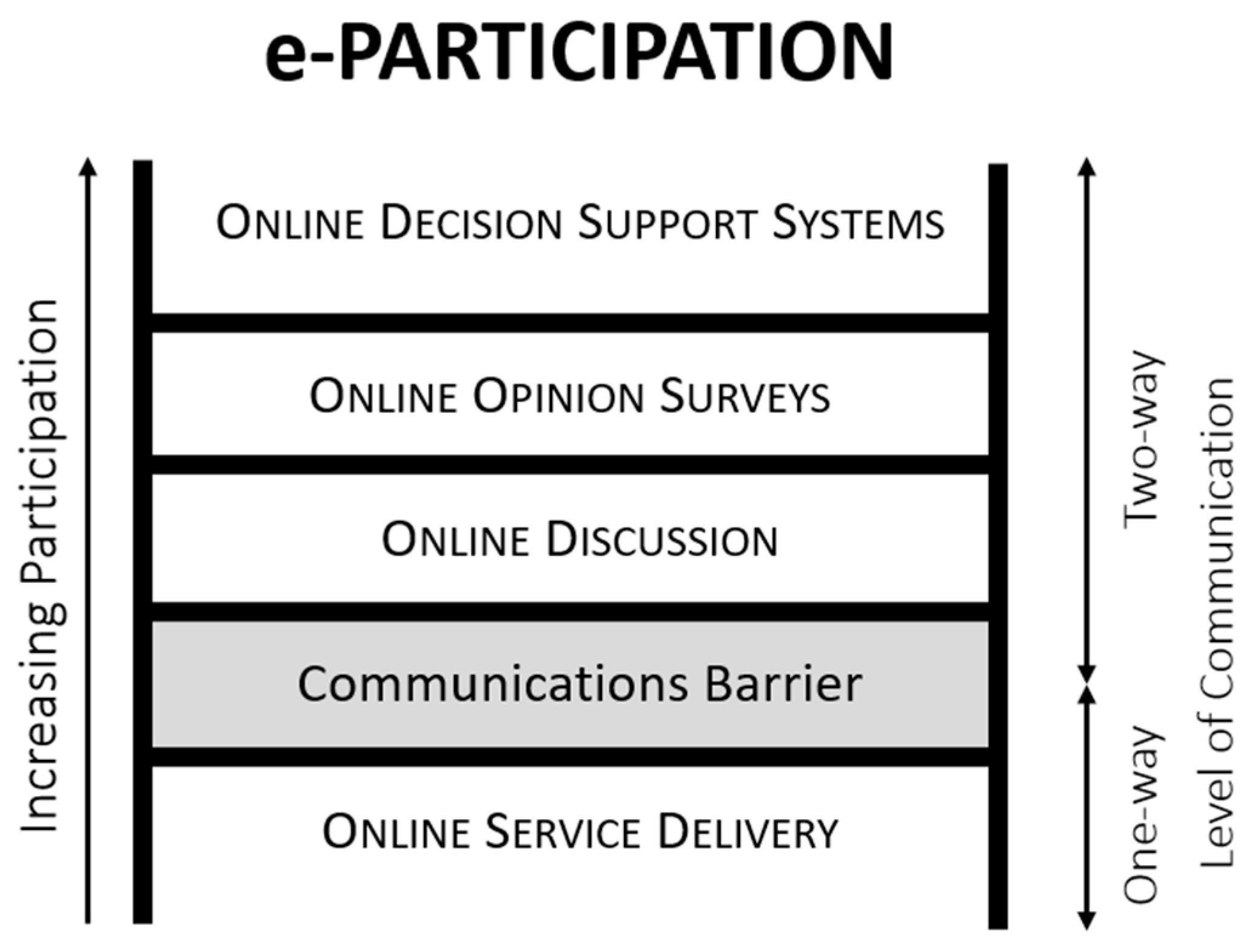
Figure 1. The ‘e-participation ladder’ according to Smyth [69].
Ijgi 14 00153 g001
Figure 2. Interface of the ‘Bürgercockpit’-application in an exemplary participation process. (a) Exemplifies an overview on all user-subscribed channels and (b) shows the specific information of a channel; (c) depicts a user post in a channel including an overview map of the post content; (d) shows a user idea; and (e) depicts the progress stage of an issue (e.g., idea, etc.) to be discussed.
Ijgi 14 00153 g002
Figure 3. Results of Question 1.6: Which of the following tasks of a participatory community planning process could be supported by a geospatial DPP? The weighted average score (mean rank) of each individual task according to its (perceived) importance on a scale from 1 (least important task) to 6 (most important task).
Ijgi 14 00153 g003
Figure 4. Highest rated Critical Success Subfactors of participatory community planning with geospatial DPPs (weighted average; All CS = all community stakeholders; CS—municipality = municipalities or LAGs; CS—CPM = community process managers; CS—A21f = Agenda21 facilitators).
Ijgi 14 00153 g004
Figure 5. Most consistently rated and most inconsistently rated Critical Success Subfactors of participatory community planning with geospatial DPPs (weighted standard deviation; All CS = all community stakeholders; CS—municipality = municipalities or LAGs; CS—CPM = community process managers; CS—A21f = Agenda21 facilitators).
Ijgi 14 00153 g005
Table 1. Levels of ‘citizen–government relationship’ according to Falco and Kleinhans [61].
LevelsSub-Levels
Information sharingInforming: One-way communication (‘broadcasting’) from government to citizens.
Consulting: One-way communication from citizens to governments.
InteractionTwo-way communication with dialogue and feedback between citizens and government representatives.
Co-productionThe public sector and citizens making better use of each other‘s assets and resources to achieve better outcomes and improved efficiency.
Self-organizationPublic matters: Citizens create solutions independently that are to be recognized, facilitated or adopted by governments and require some government action.
Private matters: Citizens share information and self-organize for matters of private interest that may develop into public demands requiring some government action.
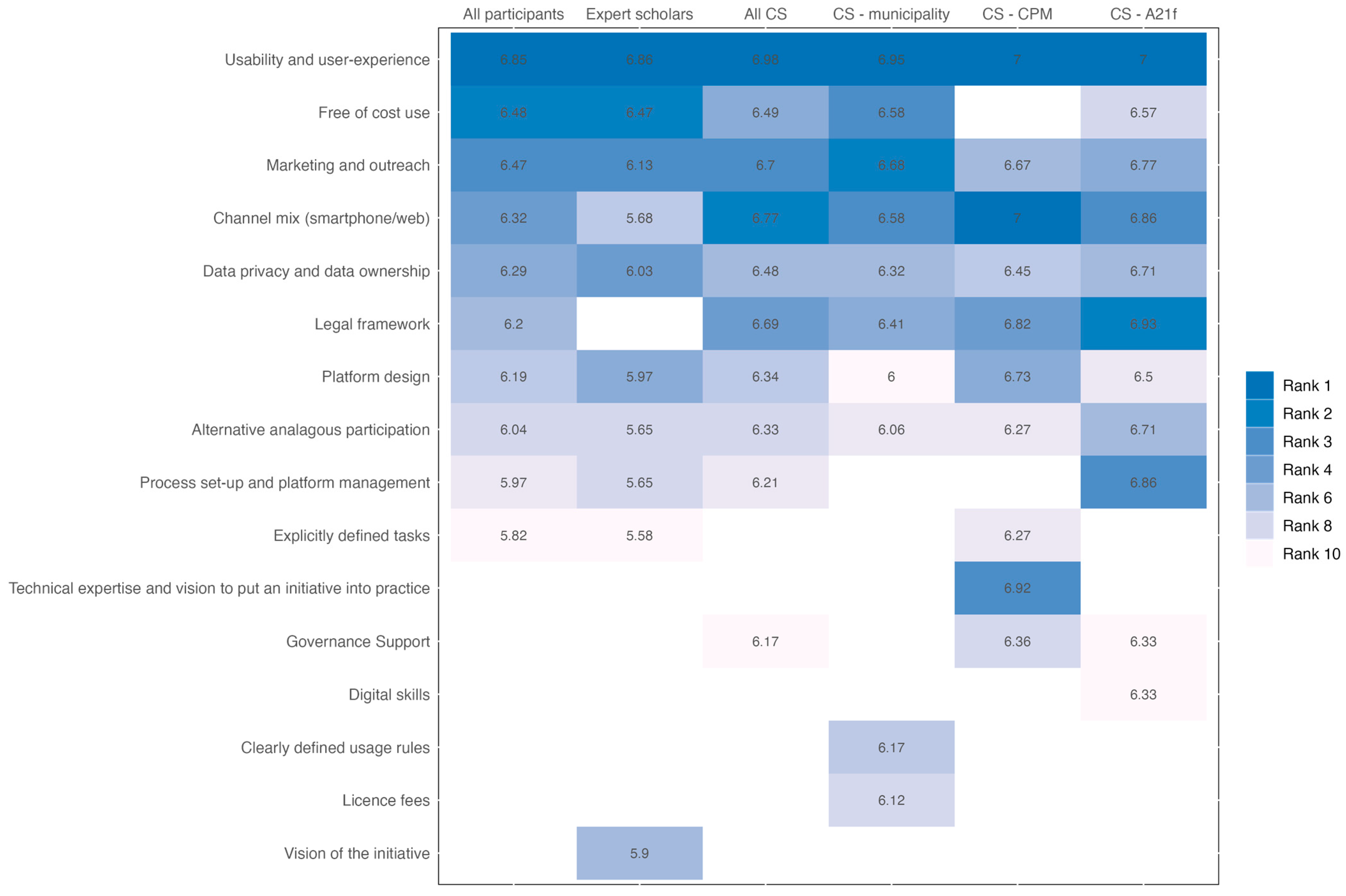
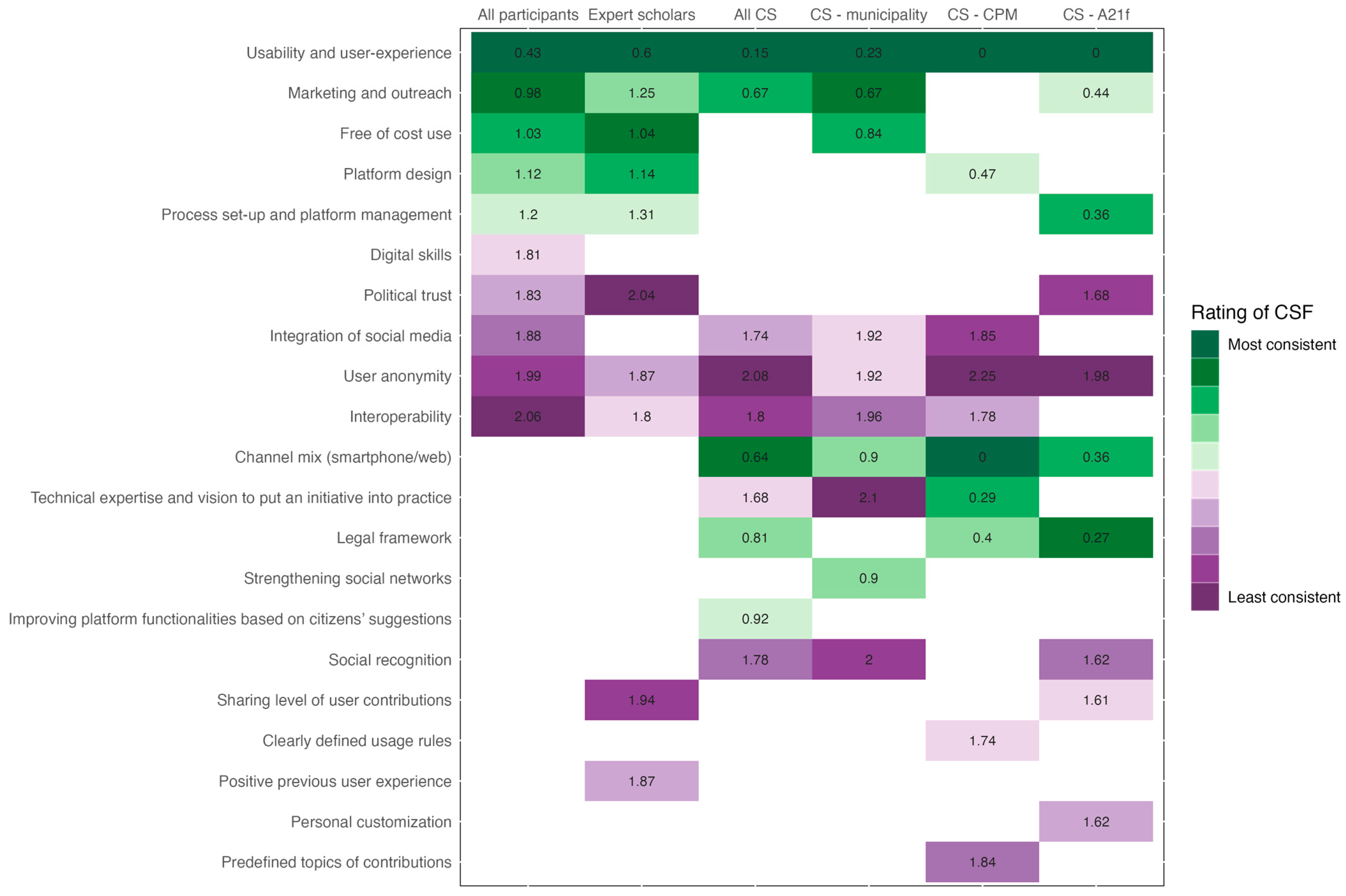
Table 2. Critical Success Factors and corresponding subfactors of participatory community planning with geospatial DPPs, based on Haltofová [58].
Critical Success FactorsCritical Success Subfactors
Motive Alignment of the crowdLong-term objectives
Kick-starting the crowd
Vision and StrategyVision of the initiative
Explicitly defined tasks
Human CapitalDigital skills
Technical expertise and vision to put an initiative into practice
Positive previous user experience
Platform design
Usability and user experience
Intuitiveness, cognitive platform
Clearly defined usage rules
Predefined topics of contributions
Citizen-Centric ApproachChannel mix (smartphone and web)
Linkage and TrustMarketing and outreach
Security and PrivacyUser anonymity
Data privacy and data ownership
Sharing level of user contributions
Technical InfrastructureInter-operability
Data QualityLocalization accuracy
ManagementProcess set-up and platform management
Alternative methods of analogous participation
Interaction OrientationFeedback on user activities
Implementation of solutions
Improving platform functionality based on citizens’ suggestions
Social NetworkingStrengthening social networks
Customization/PersonalizationPersonal customization
Institutional and social customization
User-added ValueIntegration of social media
Reward for ParticipationSocial recognition
Financial CapitalFree of cost use
License fees
External EnvironmentGovernance support
Legal framework
Political trust
Table 3. Most important Critical Success Factors and corresponding subfactors of participatory community planning with geospatial DPPs, ranked according to the answers to Q2.2 to Q2.35.
Critical Success FactorsCritical Success SubfactorsAdditional Indicators 1
Human CapitalUsability and user experience
Platform design
Low-threshold platform access (e.g., registering new users, user log-in, etc.); technical expertise of platform operators in municipalities; bug-free platforms for smooth user experience
Financial CapitalFree of cost use
Linkage and TrustMarketing and outreachPersonal stakeholder communication engaging key community figures (e.g., mayors, community activists, members of community associations, etc.); integration of platforms into the municipality website; reference to best-practice cases in other communities that use the same platform
Citizen-Centric ApproachChannel mix (smartphone/web)
Security and PrivacyData privacy and
data ownership
External EnvironmentLegal frameworkEnsuring stable political support from all representatives in the municipal council (governance support); using a platform within existing decision-making structures to ensure access to the necessary legal and organizational frameworks and financial resources necessary to implement community projects
Process ManagementAlternative analogous
participation
Process set-up and
platform management
Platforms as complement to well-established analogous participatory processes especially for small and straightforward community projects with a less challenging level of process management; time-constraints of platform operators within municipalities; efficient information flow through balanced use of notifications (avoiding ‘information overkill’); supporting process managers in setting up valid questions for community surveys
Vision and StrategyExplicitly defined tasksClearly define aims and limitations of a community process to avoid creating exaggerated expectations among citizens (particularly regarding legal, organizational, and financial constraints)
1 Additional indicators identified in the piloting phase and commercial roll-out of the ‘Bürgercockpit’-application (see Section 4.3).
Disclaimer/Publisher’s Note: The statements, opinions and data contained in all publications are solely those of the individual author(s) and contributor(s) and not of MDPI and/or the editor(s). MDPI and/or the editor(s) disclaim responsibility for any injury to people or property resulting from any ideas, methods, instructions or products referred to in the content.

