Exploring the Interactive Associations between Urban Built Environment Features and the Distribution of Offender Residences with a GeoDetector Model
Abstract
:1. Introduction
2. Study Area and Data
2.1. Study Area
2.2. Dependent Variable
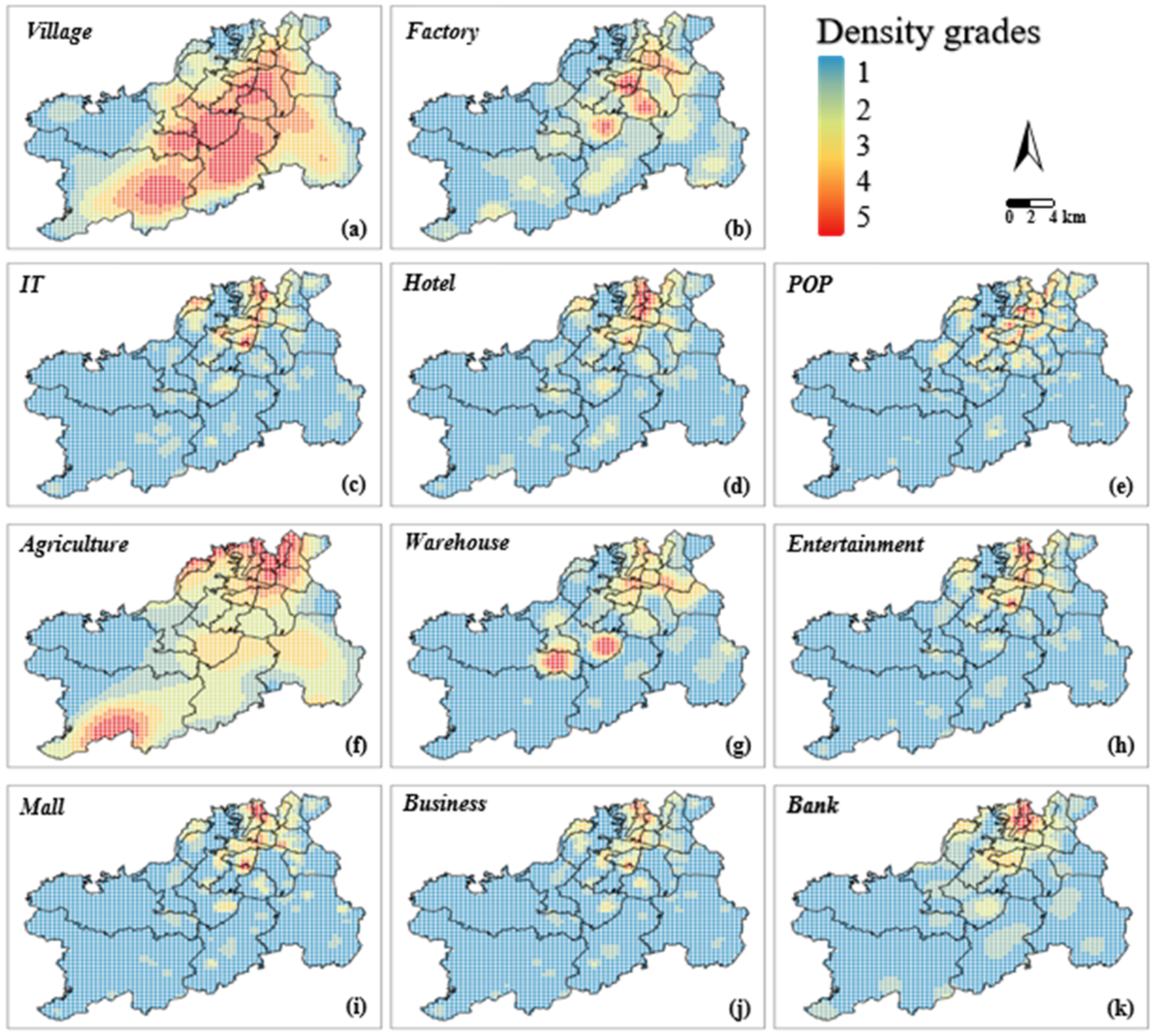
2.3. Selection of Independent Variable
3. Research Questions and Methodology
3.1. Research Questions and Hypotheses
3.2. Methodology
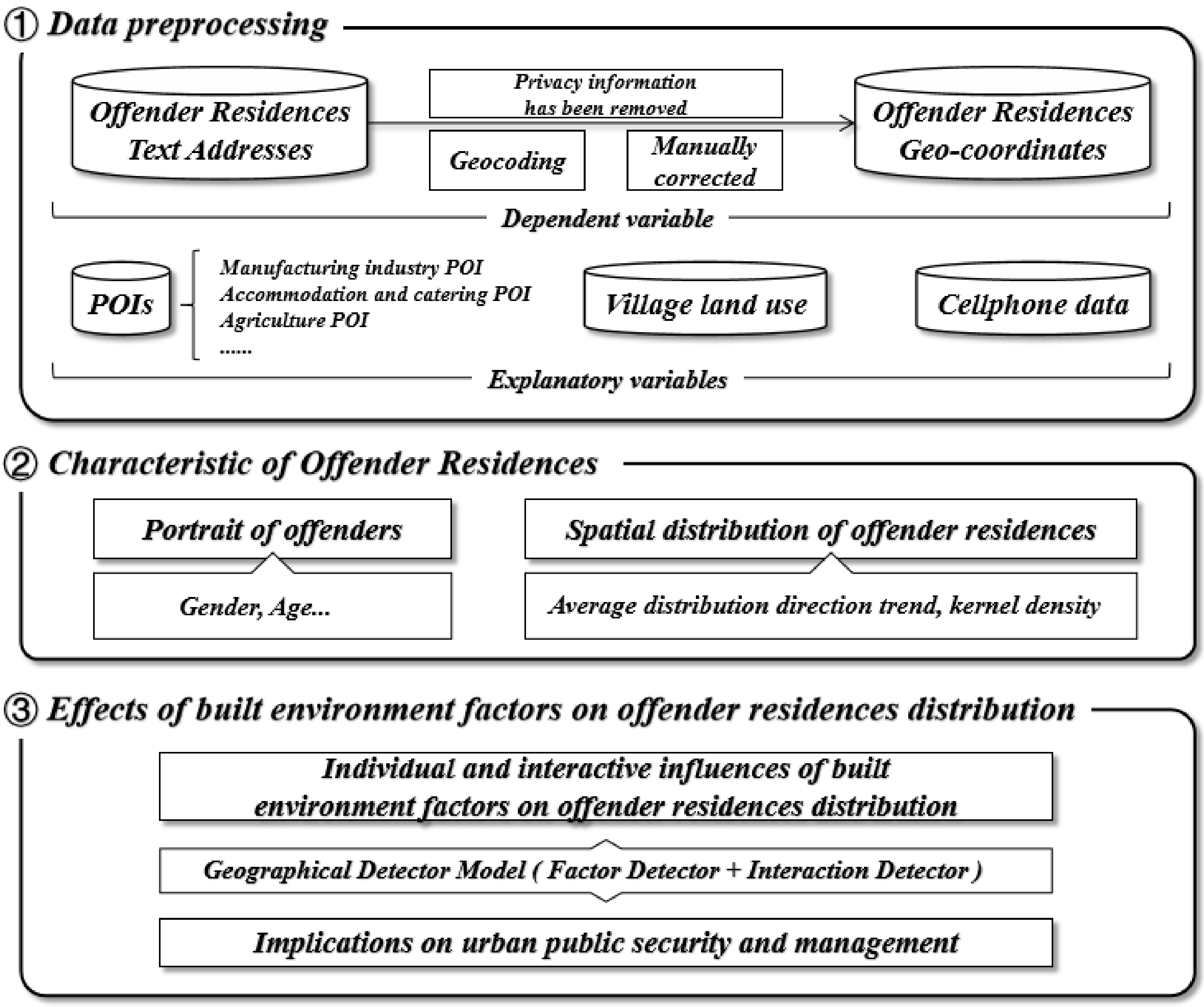
3.2.1. Preprocessing of Data
3.2.2. Kernel Density Estimation
3.2.3. Geographical Detectors Model
4. Results and Discussion
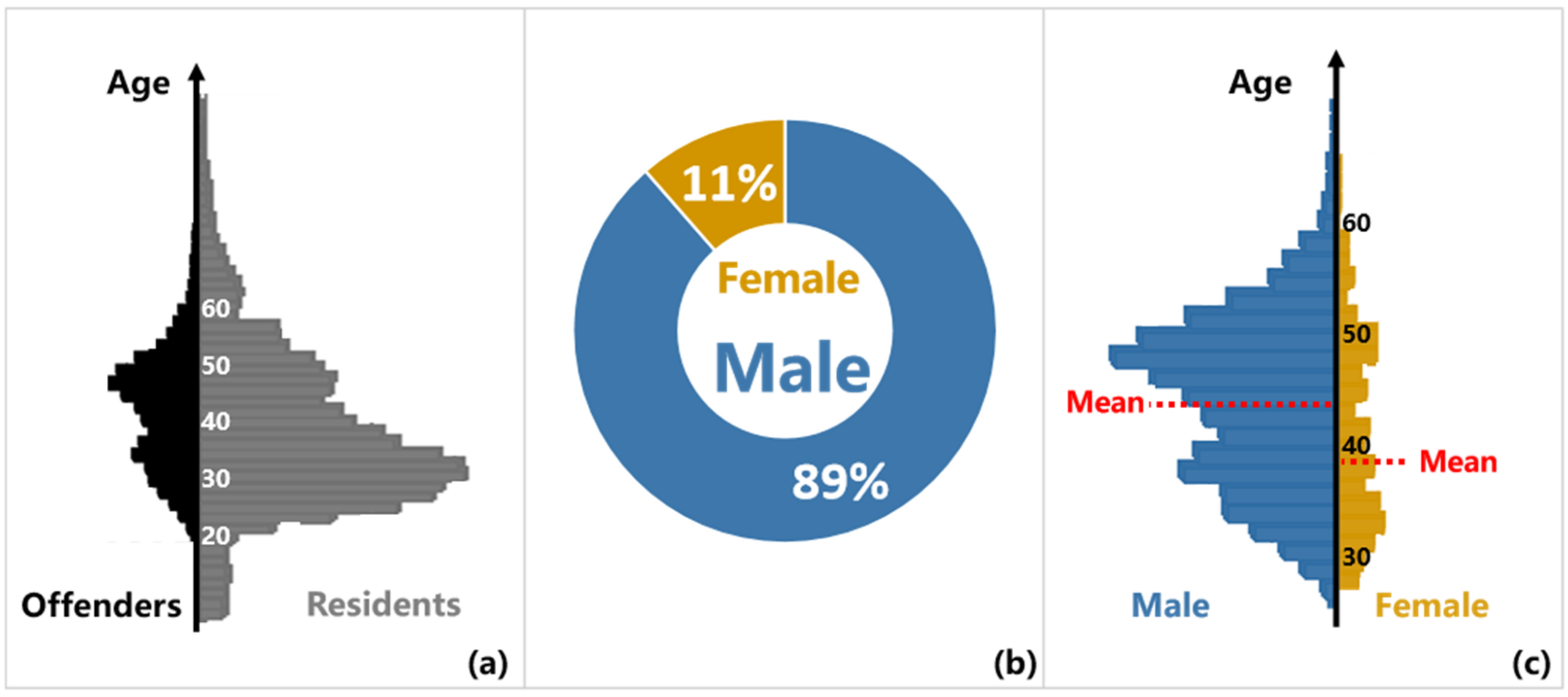
4.1. Portrait of Offenders
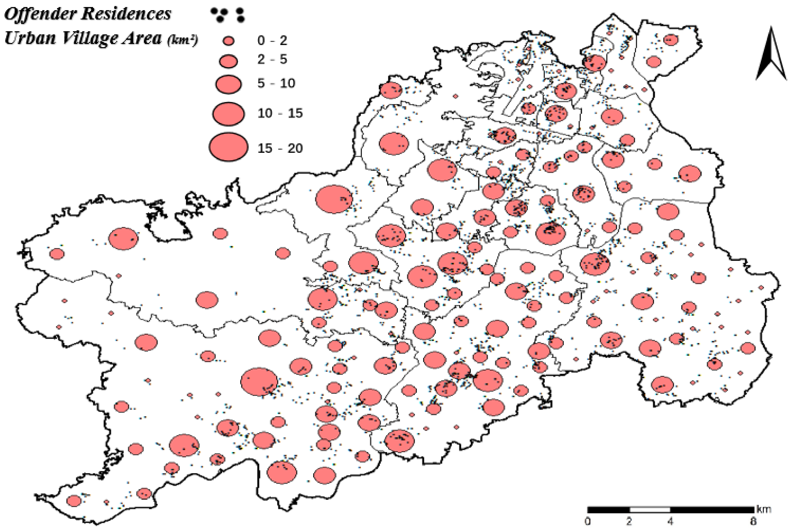
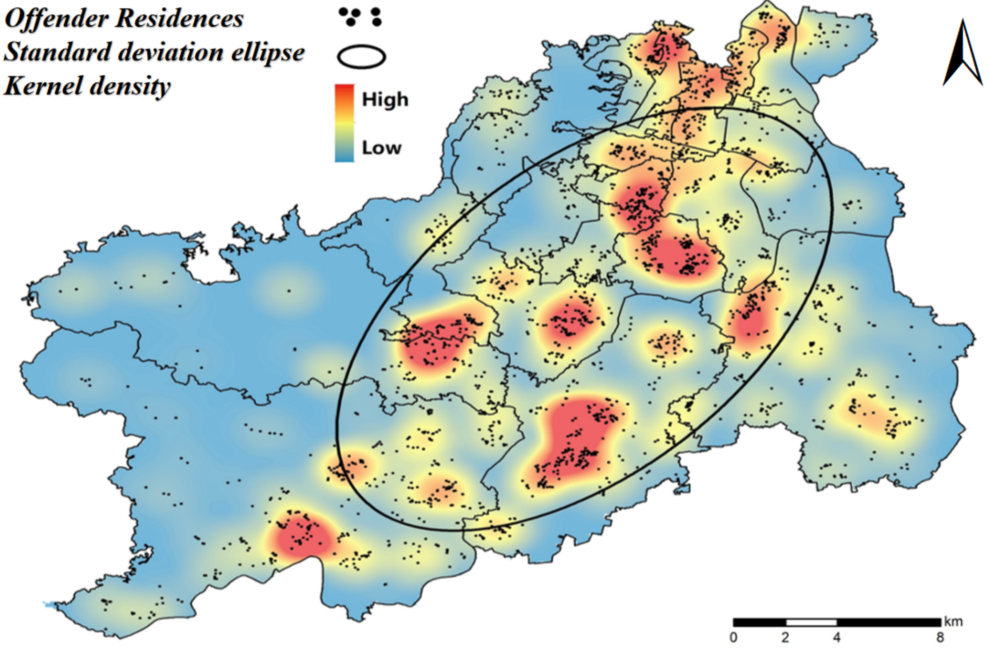
4.2. Spatial Distribution of Offender Residences
4.3. Results of GeoDetector Model
4.3.1. Factor Detection
4.3.2. Interaction Detection
4.4. Summary
4.5. Limitations and Future Research
5. Conclusions
Author Contributions
Funding
Institutional Review Board Statement
Informed Consent Statement
Data Availability Statement
Conflicts of Interest
References
- Liu, L.; Feng, J.; Ren, F.; Xiao, L. Examining the relationship between neighborhood environment and residential locations of juvenile and adult migrant burglars in China. Cities 2018, 82, 10–18. [Google Scholar] [CrossRef]
- Shaw, C.R.; McKay, H.D. Juvenile Delinquency and Urban Areas; University of Chicago Press: Chicago, IL, USA, 1942. [Google Scholar]
- Law, J.; Quick, M.; Chan, P. Open area and road density as land use indicators of young offender residential locations at the small-area level: A case study in Ontario, Canada. Urban Stud. 2016, 53, 1710–1726. [Google Scholar] [CrossRef]
- Grubesic, T.H.; Murray, A.T. Sex offender residency and spatial equity. Appl. Spat. Anal. Policy 2008, 1, 175–192. [Google Scholar] [CrossRef]
- Duwe, G. Residency restrictions and sex offender recidivism: Implications for public safety. Annotation 2009, 2, 6–8. [Google Scholar]
- Grubesic, T.H. Sex offender clusters. Appl. Geogr. 2010, 30, 2–18. [Google Scholar] [CrossRef]
- Johnson, S.D.; Summers, L. Testing ecological theories of offender spatial decision making using a discrete choice model. Crime Delinq. 2015, 61, 454–480. [Google Scholar] [CrossRef] [Green Version]
- Sampson, R.J.; Groves, W.B. Community structure and crime: Testing social-disorganization theory. Am. J. Sociol. 1989, 94, 774–802. [Google Scholar] [CrossRef] [Green Version]
- Law, J.; Quick, M. Exploring links between juvenile offenders and social disorganization at a large map scale: A Bayesian spatial modeling approach. J. Geogr. Syst. 2013, 15, 89–113. [Google Scholar] [CrossRef]
- Breetzke, G.D.; Horn, A.C. Crossing the racial divide: A spatial-ecological perspective of offenders in the City of Tshwane Metropolitan Municipality, South Africa. GeoJournal 2006, 67, 181–194. [Google Scholar] [CrossRef]
- Barbosa, G.Y. Immigrant residential segregation. In The Wiley Blackwell Encyclopedia of Urban and Regional Studies; Wiley: Hoboken, NJ, USA, 2019; pp. 1–9. [Google Scholar]
- King, R.D.; South, S.J. Crime, race, and the transition to marriage. J. Fam. Issues 2011, 32, 99–126. [Google Scholar] [CrossRef]
- South, S.J.; Messner, S.F. Crime and demography: Multiple linkages, reciprocal relations. Annu. Rev. Sociol. 2000, 26, 83–106. [Google Scholar] [CrossRef]
- Hirschman, C.; Tolnay, S.E. Social demography. In Handbook of Population; Springer: Boston, MA, USA, 2005; pp. 419–449. [Google Scholar]
- Cohen, L.E.; Felson, M. Social change and crime rate trends: A routine activity approach. In Classics in Environmental Criminology; Routledge: Oxfordshire, UK, 1979; pp. 588–608. [Google Scholar]
- Brantingham, P.L.; Brantingham, P.J. A theoretical model of crime hot spot generation. Stud. Crime Crime Prev. 1999, 8, 7–26. [Google Scholar]
- Brantingham, P.L.; Brantingham, P.J. Nodes, paths and edges: Considerations on the complexity of crime and the physical environment. J. Environ. Psychol. 1993, 13, 3–28. [Google Scholar] [CrossRef]
- Brantingham, P.J. Criminality of place: Crime generators and crime attractors. Eur. J. Crim. Policy Res. 1995, 3, 5–26. [Google Scholar] [CrossRef]
- Bernasco, W. A sentimental journey to crime: Effects of residential history on crime location choice. Criminology 2010, 48, 389–416. [Google Scholar] [CrossRef]
- Mustaine, E.E.; Tewksbury, R.; Stengel, K.M. Residential location and mobility of registered sex offenders. Am. J. Crim. Justice 2006, 30, 177–192. [Google Scholar] [CrossRef]
- Tewksbury, R.; Mustaine, E.E. Where registered sex offenders live: Community characteristics and proximity to possible victims. Vict. Offenders 2008, 3, 86–98. [Google Scholar] [CrossRef]
- Wallis, C.P.; Maliphant, R. Delinquent areas in the county of London: Ecological factors. Br. J. Criminol. 1967, 7, 250–284. [Google Scholar] [CrossRef]
- Roncek, D.W.; Bell, R. Bars, blocks, and crimes. J. Environ. Syst. 1981, 11, 35–47. [Google Scholar] [CrossRef]
- McCord, E.S.; Ratcliffe, J.H. Intensity value analysis and the criminogenic effects of land use features on local crime patterns. Crime Patterns Anal. 2009, 2, 17–30. [Google Scholar]
- Felson, M.; de Melo, S.N.; Boivin, R. Risk of outdoor rape and proximity to bus stops, bars, and residences. Violence Vict. 2022, 36, 723–738. [Google Scholar]
- Hart, T.C.; Miethe, T.D. Street robbery and public bus stops: A case study of activity nodes and situational risk. Secur. J. 2014, 27, 180–193. [Google Scholar] [CrossRef]
- Caplan, J.M.; Kennedy, L.W.; Miller, J. Risk terrain modeling: Brokering criminological theory and GIS methods for crime forecasting. Justice Q. 2011, 28, 360–381. [Google Scholar] [CrossRef]
- Drawve, G. A metric comparison of predictive hot spot techniques and RTM. Justice Q. 2016, 33, 369–397. [Google Scholar] [CrossRef]
- Drawve, G.; Moak, S.C.; Berthelot, E.R. Predictability of gun crimes: A comparison of hot spot and risk terrain modelling techniques. Polic. Soc. 2016, 26, 312–331. [Google Scholar] [CrossRef]
- Connealy, N.T.; Piza, E.L. Risk factor and high-risk place variations across different robbery targets in Denver, Colorado. J. Crim. Justice 2019, 60, 47–56. [Google Scholar] [CrossRef]
- Adeyemi, R.A.; Mayaki, J.; Zewotir, T.T.; Ramroop, S. Demography and crime: A spatial analysis of geographical patterns and risk factors of Crimes in Nigeria. Spat. Stat. 2021, 41, 100485. [Google Scholar] [CrossRef]
- Sherman, L.W.; Gartin, P.R.; Buerger, M.E. Hot spots of predatory crime: Routine activities and the criminology of place. Criminology 1989, 27, 27–56. [Google Scholar] [CrossRef]
- Eck, J.; Chainey, S.; Cameron, J.; Wilson, R. Mapping Crime: Understanding Hotspots; U.S. Department of Justice Office of Justice Programs: Washington, DC, USA, 2005. [Google Scholar]
- Hart, T.C. Investigating crime pattern stability at micro-temporal intervals: Implications for crime analysis and hotspot policing strategies. Crim. Justice Rev. 2021, 46, 173–189. [Google Scholar] [CrossRef]
- Mondal, S.; Singh, D.; Kumar, R. Crime hotspot detection using statistical and geospatial methods: A case study of Pune City, Maharashtra, India. GeoJournal 2022, 1–17. [Google Scholar] [CrossRef]
- Hodgkinson, T.; Andresen, M.A. Changing spatial patterns of residential burglary and the crime drop: The need for spatial data signatures. J. Crim. Justice 2019, 61, 90–100. [Google Scholar] [CrossRef]
- Zhao, X.; Tang, J. Modeling temporal-spatial correlations for crime prediction. In Proceedings of the 2017 ACM on Conference on Information and Knowledge Management, Singapore, 6–10 November 2017; pp. 497–506. [Google Scholar]
- Piza, E.L.; Carter, J.G. Predicting initiator and near repeat events in spatiotemporal crime patterns: An analysis of residential burglary and motor vehicle theft. Justice Q. 2018, 35, 842–870. [Google Scholar] [CrossRef]
- Yang, B.; Liu, L.; Lan, M.; Wang, Z.; Zhou, H.; Yu, H. A spatio-temporal method for crime prediction using historical crime data and transitional zones identified from nightlight imagery. Int. J. Geogr. Inf. Sci. 2020, 34, 1740–1764. [Google Scholar] [CrossRef]
- Brownstein, J.S.; Green, T.C.; Cassidy, T.A.; Butler, S.F. Geographic information systems and pharmacoepidemiology: Using spatial cluster detection to monitor local patterns of prescription opioid abuse. Pharmacoepidemiol. Drug Saf. 2010, 19, 627–637. [Google Scholar] [CrossRef] [Green Version]
- Joshi, A.; Sabitha, A.S.; Choudhury, T. Crime analysis using K-means clustering. In Proceedings of the 2017 3rd International Conference on Computational Intelligence and Networks (CINE), Odisha, India, 28 October 2017; pp. 33–39. [Google Scholar]
- Kalinic, M.; Krisp, J.M. Kernel density estimation (KDE) vs. hot-spot analysis—Detecting criminal hot spots in the City of San Francisco. In Proceedings of the 21st Conference on Geo-Information Science, Lund, Sweden, 12–15 June 2018. [Google Scholar]
- Mburu, L.W.; Zipf, A. A Spatial Approach to Surveying Crime—Problematic Areas at the Street Level. In Connecting a Digital Europe Through Location and Place; Springer: Berlin/Heidelberg, Germany, 2014. [Google Scholar]
- Levine, N. Crimestat IV: A Spatial Statistics Program for the Analysis of Crime Incident Locations, Version 4.0; Ned Levine & Associates: Houston, TX, USA, 2013. [Google Scholar]
- Chainey, S.; Ratcliffe, J. Identifying crime hotspots. In GIS and Crime Mapping; John Wiley & Sons: Hoboken, NJ, USA, 2005; pp. 145–182. [Google Scholar]
- Ratcliffe, J. Crime mapping: Spatial and temporal challenges. In Handbook of Quantitative Criminology; Springer: New York, NY, USA, 2010; pp. 5–24. [Google Scholar]
- Chainey, S.P. Examining the influence of cell size and bandwidth size on kernel density estimation crime hotspot maps for predicting spatial patterns of crime. Bull. Geogr. Soc. Liege 2013, 60, 7–19. [Google Scholar]
- Hart, T.; Zandbergen, P. Kernel density estimation and hotspot mapping: Examining the influence of interpolation method, grid cell size, and bandwidth on crime forecasting. Polic. Int. J. Police Strateg. Manag. 2014, 37, 305–323. [Google Scholar] [CrossRef]
- Xiao, L.; Liu, L.; Song, G.; Ruiter, S.; Zhou, S. Journey-to-crime distances of residential burglars in China disentangled: Origin and destination effects. ISPRS Int. J. Geo-Inf. 2018, 7, 325. [Google Scholar] [CrossRef] [Green Version]
- Browning, C.R.; Byron, R.A.; Calder, C.A.; Krivo, L.J.; Kwan, M.P.; Lee, J.Y.; Peterson, R.D. Commercial density, residential concentration, and crime: Land use patterns and violence in neighborhood context. J. Res. Crime Delinq. 2010, 47, 329–357. [Google Scholar] [CrossRef]
- Xia, Z.; Stewart, K.; Fan, J. Incorporating space and time into random forest models for analyzing geospatial patterns of drug-related crime incidents in a major us metropolitan area. Comput. Environ. Urban Syst. 2021, 87, 101599. [Google Scholar] [CrossRef]
- LeSage, J.; Pace, R.K. Introduction to Spatial Econometrics; Chapman and Hall: London, UK, 2009. [Google Scholar]
- Chen, J.; Liu, L.; Liu, H.; Long, D.; Xu, C.; Zhou, H. The Spatial Heterogeneity of Factors of Drug Dealing: A Case Study from ZG, China. ISPRS Int. J. Geo-Inf. 2020, 9, 205. [Google Scholar] [CrossRef] [Green Version]
- Chen, J.; Liu, L.; Zhou, S.; Xiao, L.; Song, G.; Ren, F. Modeling spatial effect in residential burglary: A case study from ZG city, China. ISPRS Int. J. Geo-Inf. 2017, 6, 138. [Google Scholar] [CrossRef] [Green Version]
- Chen, J.; Liu, L.; Xiao, L.; Xu, C.; Long, D. Integrative analysis of spatial heterogeneity and overdispersion of crime with a geographically weighted negative binomial model. ISPRS Int. J. Geo-Inf. 2020, 9, 60. [Google Scholar] [CrossRef] [Green Version]
- Wang, J.F.; Li, X.H.; Christakos, G.; Liao, Y.L.; Zhang, T.; Gu, X.; Zheng, X.Y. Geographical detectors-based health risk assessment and its application in the neural tube defects study of the Heshun Region, China. Int. J. Geogr. Inf. Sci. 2010, 24, 107–127. [Google Scholar] [CrossRef]
- Wang, J.; Zhang, T.; Fu, B. A measure of spatial stratified heterogeneity. Ecol. Indic. 2016, 67, 250–256. [Google Scholar] [CrossRef]
- Weisburd, D.; Groff, E.R.; Yang, S.M. The Criminology of Place: Street Segments and our Understanding of the Crime Problem; Oxford University Press: Oxford, UK, 2012. [Google Scholar]
- Shaw, C.R.; McKay, H.D. Juvenile delinquency and urban areas: A study of rates of delinquency in relation to differential characteristics of local communities in American cities (1969). In Classics in Environmental Criminology; Routledge: Oxfordshire, UK, 2010; pp. 103–140. [Google Scholar]
- Wang, Z.; Liu, L.; Zhou, H.; Lan, M. How is the confidentiality of crime locations affected by parameters in kernel density estimation? ISPRS Int. J. Geo-Inf. 2019, 8, 544. [Google Scholar] [CrossRef] [Green Version]
- Chainey, S.; Tompson, L.; Uhlig, S. The utility of hotspot mapping for predicting spatial patterns of crime. Secur. J. 2008, 21, 4–28. [Google Scholar] [CrossRef]
- Manepalli, U.R.; Bham, G.H.; Kandada, S. Evaluation of hotspots identification using kernel density estimation (K) and Getis-Ord (Gi*) on I-630. In Proceedings of the 3rd International Conference on Road Safety and Simulation, Indianapolis, IN, USA, 14–16 September 2011. [Google Scholar]
- Xie, Z.; Yan, J. Kernel density estimation of traffic accidents in a network space. Comput. Environ. Urban Syst. 2008, 32, 396–406. [Google Scholar] [CrossRef] [Green Version]
- Ihlanfeldt, K.R. Rail transit and neighborhood crime: The case of Atlanta, Georgia. South Econ. J. 2003, 70, 273–294. [Google Scholar] [CrossRef]
- Xu, C.; Chen, X.; Liu, L.; Lan, M.; Chen, D. Assessing Impacts of New Subway Stations on Urban Thefts in the Sur-rounding Areas. ISPRS Int. J. Geo-Inf. 2021, 10, 632. [Google Scholar] [CrossRef]
- Willits, D.; Broidy, L.; Denman, K. Schools, Neighborhood Risk Factors, and Crime. Crime Delinq. 2013, 59, 292–315. [Google Scholar] [CrossRef]
- Murray, R.K.; Swatt, M.L. Disaggregating the Relationship Between Schools and Crime: A Spatial Analysis. Crime Delinq. 2013, 59, 163–190. [Google Scholar] [CrossRef]
- Bursik, R.J. Social disorganization and theories of crime and delinquency: Problems and prospects. Criminology 1988, 26, 519–552. [Google Scholar] [CrossRef]
- Bursik, R.J.; Webb, J. Community Change and Patterns of Delinquency. Am. J. Soc. 1982, 88, 24–42. [Google Scholar] [CrossRef]
- Shaw, C.R. A Delinquency Area; Behavior Research Fund Monographs; Moore, M.E., Ed.; University of Chicago Press: Chicago, IL, USA, 1931; pp. 13–25. [Google Scholar]
- Hesseling, R.B.P. Using data on offender mobility in ecological research. J. Quant. Criminol. 1992, 8, 95–112. [Google Scholar] [CrossRef]
- Zhang, X.; Gao, F.; Liao, S.; Zhou, F.; Cai, G.; Li, S. Portraying Citizens’ Occupations and Assessing Urban Occupation Mixture with Mobile Phone Data: A Novel Spatiotemporal Analytical Framework. ISPRS Int. J. Geo-Inf. 2021, 10, 392. [Google Scholar] [CrossRef]
- Deng, X.; Liu, Y.; Gao, F.; Liao, S.; Zhou, F.; Cai, G. Spatial Distribution and Mechanism of Urban Occupation Mix-ture in Guangzhou: An Optimized GeoDetector-Based Index to Compare Individual and Interactive Effects. ISPRS Int. J. Geo-Inf. 2021, 10, 659. [Google Scholar] [CrossRef]
- Gao, F.; Li, S.; Tan, Z.; Wu, Z.; Zhang, X.; Huang, G.; Huang, Z. Understanding the modifiable areal unit problem in dockless bike sharing usage and exploring the interactive effects of built environment factors. Int. J. Geogr. Inf. Sci. 2021, 35, 1–21. [Google Scholar] [CrossRef]
- Song, Y.; Zenou, Y.; Ding, C. Let’s not throw the baby out with the bath water: The role of urban villages in housing rural migrants in China. Urban Stud. 2008, 45, 313–330. [Google Scholar] [CrossRef] [Green Version]
- Zhang, L.; Zhao, S.X.B.; Tian, J.P. Self-help in housing and Chengzhongcun in China’s urbanization. Int. J. Urban Reg. Res. 2003, 27, 912–937. [Google Scholar] [CrossRef]
- Wang, Y.P.; Wang, Y.; Wu, J. Housing migrant workers in rapidly urbanizing regions: A study of the Chinese model in Shenzhen. Hous. Stud. 2010, 25, 83–100. [Google Scholar] [CrossRef]
- Cheng, Z.; Guo, F.; Hugo, G.; Yuan, X. Employment and wage discrimination in the Chinese cities: A comparative study of migrants and locals. Habitat Int. 2013, 39, 246–255. [Google Scholar] [CrossRef]
- Kemshall, H. Sleep safely: Crime risks may be smaller than you think. Soc. Policy Adm. 2010, 31, 247–259. [Google Scholar] [CrossRef]
- Ho, T.; Zhao, J.; Brown, M.P. Examining hotel crimes from police crime reports. Crime Prev. Community Saf. 2009, 11, 21–33. [Google Scholar] [CrossRef]
- Harper, D.W.J. Comparing tourists crime victimization. Ann. Tour. Res. 2001, 28, 1053–1056. [Google Scholar] [CrossRef]
- Kelly, I. Tourist destination crime rates: An examination of Cairns and the Gold Coast, Australia. J. Tour. Stud. 1993, 4, 2–11. [Google Scholar]
- Steven, S. Social Structure and Swedish Crime Rates A Time-Series Analysis, 1950–1979. Criminology 2006, 20, 499–514. [Google Scholar] [CrossRef]
- Wei, L.; Yan, X. Transformation of ‘urban village’ and feasible mode. City Plan. Rev. 2005, 7, 9–13. [Google Scholar]
- Zheng, S.; Long, F.; Fan, C.C.; Gu, Y. Urban villages in China: A 2008 survey of migrant settlements in Beijing. Eurasian Geogr. Econ. 2009, 50, 425–446. [Google Scholar] [CrossRef] [Green Version]
- Gao, F.; Li, S.; Tan, Z.; Zhang, X.; Lai, Z.; Tan, Z. How Is Urban Greenness Spatially Associated with Dockless Bike Sharing Usage on Weekdays, Weekends, and Holidays? ISPRS Int. J. Geo-Inf. 2021, 10, 238. [Google Scholar] [CrossRef]
- Li, S.; Lyu, D.; Huang, G.; Zhang, X.; Gao, F.; Chen, Y.; Liu, X. Spatially varying impacts of built environment factors on rail transit ridership at station level: A case study in Guangzhou, China. J. Transp. Geogr. 2017, 82, 102631. [Google Scholar] [CrossRef]
- Fotheringham, A.S.; Charlton, M.E.; Brunsdon, C. Geographically weighted regression: A natural evolution of the expansion method for spatial data analysis. Environ. Plan. A 1998, 30, 1905–1927. [Google Scholar] [CrossRef]
- Rossmo, D.K. Geographic Profiling, 1st ed.; Routledge: Oxfordshire, UK, 1999. [Google Scholar] [CrossRef]
- Gao, F.; Li, S.; Tan, Z.; Liao, S. Visualizing the spatiotemporal characteristics of Dockless bike sharing usage in Shenzhen, China. J. Geovis. Spat. Anal. 2022, 6, 12. [Google Scholar] [CrossRef]


| FID | Residential Address | Date of Arrest | Longitude | Latitude |
|---|---|---|---|---|
| 1 | No. 1, xx Road, A District, B City | 5 January 2020 | 11x.xx | 3x.xx |
| 2 | No. 2, yy Road, C District, B City | 16 March 2020 | 12x.xx | 2x.xx |
| … | … | … | … |
| Abbreviations | Attributes | Source | |
|---|---|---|---|
| Dependent variable | Count of offender residences | Bureau of Public Security, 2020 | |
| Independent variables | Village | Area of urban village land use | Land Use Bureau, 2020 |
| Factory | The density of factories (factories manufacturing clothing, belts, shoes, and cosmetics) | Baidu Maps, 2020 | |
| Hotel | The density of hotels (hotels, guesthouses, and home stays) | Baidu Maps, 2020 | |
| Agriculture | The density of agricultural facilities (agricultural tools shops, machinery repair shops, agricultural product processing shops, and agricultural labor agency shops) | Baidu Maps, 2020 | |
| Warehouse | The density of warehousing (warehouses and logistics transfer stations) | Baidu Maps, 2020 | |
| Entertainment | The density of entertainment places (KTVs, bars, net bars, and massage parlors) | Baidu Maps, 2020 | |
| IT | The density of IT-related companies | Baidu Maps, 2020 | |
| Mall | The density of stores and malls (shopping malls and convenience stores) | Baidu Maps, 2020 | |
| Business | The density of business-leasing service companies (enterprise management services, legal services, consulting and investigation, advertising industry, and professional intermediary services) | Baidu Maps, 2020 | |
| Bank | Density of banks | Baidu Maps, 2020 | |
| POP | Population density | Mobile communication operator, 2020 |
| Description | Interaction | Degree of Interaction Associations |
|---|---|---|
| Enhance, nonlinear | Very strong (interaction associations were larger than the sum of individual associations) | |
| Independent | Independent (interaction associations equaled the sum of individual associations) | |
| Enhance, bivariate | Strong (interaction associations were larger than the MAX of individual associations and smaller than the sum of individual associations) | |
| Enhance/weaken, univariate | Weak (interaction associations were larger than the MIN of individual associations and smaller than the MAX of individual associations) | |
| Weaken, nonlinear | Very weak (interaction associations were smaller than the MIN of individual associations) |
| Independent Variables | q Value (95% CI) |
|---|---|
| Factory | 0.43 *** (0.4016–0.4525) |
| Village | 0.38 *** (0.3590–0.4114) |
| Hotel | 0.34 *** (0.3087–0.3624) |
| Agriculture | 0.26 *** (0.2297–0.2834) |
| Warehouse | 0.24 *** (0.2152–0.2686) |
| Entertainment | 0.24 *** (0.2111–0.2643) |
| IT | 0.23 *** (0.2016–0.2546) |
| POP | 0.23 *** (0.2008–0.2538) |
| Mall | 0.22 *** (0.1957–0.2484) |
| Business | 0.21 ** (0.1856–0.2380) |
| Bank | 0.16 ** (0.1342–0.1832) |
| Village | Bank | Agriculture | Mall | Entertainment | IT | Warehouse | Factory | Hotel | Business | POP | |
|---|---|---|---|---|---|---|---|---|---|---|---|
| Village | 0.39 | ||||||||||
| Bank | 0.52 | 0.16 | |||||||||
| Agriculture | 0.51 | 0.34 | 0.26 | ||||||||
| Mall | 0.56 | 0.27 | 0.39 | 0.22 | |||||||
| Entertainment | 0.58 | 0.27 | 0.39 | 0.26 | 0.24 | ||||||
| IT | 0.55 | 0.28 | 0.37 | 0.26 | 0.28 | 0.23 | |||||
| Warehouse | 0.51 | 0.33 | 0.45 | 0.33 | 0.35 | 0.34 | 0.24 | ||||
| Factory | 0.56 | 0.48 | 0.53 | 0.48 | 0.50 | 0.48 | 0.49 | 0.43 | |||
| Hotel | 0.65 | 0.37 | 0.46 | 0.36 | 0.36 | 0.37 | 0.43 | 0.52 | 0.34 | ||
| Business | 0.57 | 0.27 | 0.37 | 0.24 | 0.27 | 0.27 | 0.33 | 0.48 | 0.35 | 0.21 | |
| POP | 0.55 | 0.28 | 0.37 | 0.29 | 0.30 | 0.30 | 0.35 | 0.48 | 0.37 | 0.28 | 0.23 |
 .
.Publisher’s Note: MDPI stays neutral with regard to jurisdictional claims in published maps and institutional affiliations. |
© 2022 by the authors. Licensee MDPI, Basel, Switzerland. This article is an open access article distributed under the terms and conditions of the Creative Commons Attribution (CC BY) license (https://creativecommons.org/licenses/by/4.0/).
Share and Cite
Wan, T.; Shi, B. Exploring the Interactive Associations between Urban Built Environment Features and the Distribution of Offender Residences with a GeoDetector Model. ISPRS Int. J. Geo-Inf. 2022, 11, 369. https://doi.org/10.3390/ijgi11070369
Wan T, Shi B. Exploring the Interactive Associations between Urban Built Environment Features and the Distribution of Offender Residences with a GeoDetector Model. ISPRS International Journal of Geo-Information. 2022; 11(7):369. https://doi.org/10.3390/ijgi11070369
Chicago/Turabian StyleWan, Tao, and Buhai Shi. 2022. "Exploring the Interactive Associations between Urban Built Environment Features and the Distribution of Offender Residences with a GeoDetector Model" ISPRS International Journal of Geo-Information 11, no. 7: 369. https://doi.org/10.3390/ijgi11070369
APA StyleWan, T., & Shi, B. (2022). Exploring the Interactive Associations between Urban Built Environment Features and the Distribution of Offender Residences with a GeoDetector Model. ISPRS International Journal of Geo-Information, 11(7), 369. https://doi.org/10.3390/ijgi11070369


