Article

Hydrological Web Services for Operational Flood Risk Monitoring and Forecasting at Local Scale in Niger

by
Tiziana De Filippis
1,*,
Leandro Rocchi
1,
Giovanni Massazza
2,3,
Alessandro Pezzoli
2,
Maurizio Rosso
4,
Mohamed Housseini Ibrahim
5 and
Vieri Tarchiani
1
1
Istituto per la BioEconomia-Consiglio Nazionale delle Ricerche (IBE-CNR), Via Madonna del Piano 10, 50019 Sesto Fiorentino, Italy
2
Interuniversity Department of Regional and Urban Studies and Planning (DIST), Politecnico di Torino & Università di Torino, Viale Mattioli 39, 10125 Turin, Italy
3
Agenzia Interregionale per il Fiume Po (AIPo), 10024 Moncalieri, Italy
4
Department of Environment, Land and Infrastructure Engineering (DIATI), Politecnico di Torino, Corso Duca degli Abruzzi 24, 10129 Turin, Italy
5
Direction de l’Hydrologie (DH), Ministère de l’Hydraulique et de l’Assainissement du Niger, Niamey B.P. 257, Niger
*
Author to whom correspondence should be addressed.
ISPRS Int. J. Geo-Inf. 2022, 11(4), 236; https://doi.org/10.3390/ijgi11040236
Submission received: 21 January 2022 / Revised: 24 March 2022 / Accepted: 2 April 2022 / Published: 5 April 2022

Abstract

:
Emerging hydrological services provide stakeholders and political authorities with useful and reliable information to support the decision-making process and develop flood risk management strategies. Most of these services adopt the paradigm of open data and standard web services, paving the way to increase distributed hydrometeorological services’ interoperability. Moreover, sharing of data, models, information, and the use of open-source software, greatly contributes to expanding the knowledge on flood risk and to increasing flood preparedness. Nevertheless, services’ interoperability and open data are not common in local systems implemented in developing countries. This paper presents the web platform and related services developed for the Local Flood Early Warning System of the Sirba River in Niger (SLAPIS) to tailor hydroclimatic information to the user’s needs, both in content and format. Building upon open-source software components and interoperable web services, we created a software framework covering data capture and storage, data flow management procedures from several data providers, real-time web publication, and service-based information dissemination. The geospatial infrastructure and web services respond to the actual and local decision-making context to improve the usability and usefulness of information derived from hydrometeorological forecasts, hydraulic models, and real-time observations. This paper presents also the results of the three years of operational campaigns for flood early warning on the Sirba River in Niger. Semiautomatic flood warnings tailored and provided to end users bridge the gap between available technology and local users’ needs for adaptation, mitigation, and flood risk management, and make progress toward the sustainable development goals.

1. Introduction

Flood events are a global issue that impacts the local, national, and transnational level across various sectors [1]. African countries are particularly vulnerable to severe flooding in river basins with a high number of casualties and high socioeconomic impact [2]. Concerning West Africa, the literature reports an increasing number of extreme floods, floods magnitude, and flood-related impacts in the past two decades [3,4,5,6]. Extreme flooding has since the beginning of the new millennium become a crucial issue for the development of Sahelian countries [3], causing casualties, health emergencies, losses of houses, infrastructures, goods, and crops. The positive trends of flood magnitude and frequency in the Sahelian regions have been analyzed as consequence of climate and land use/land cover changes [7,8] and their relationships with the number of people affected in the Sahelian part of the Niger River Basin are also reported by Aich et al. [8]. Furthermore, floods increase land degradation, erosion, and silting, extending their severe consequences on rural communities’ food insecurity. The Medium Niger River Basin (MNRB) is characterized by dramatic upward trends of hydrological indicators (AMAX and runoff coefficients) consistent with the increase in both the annual cumulated precipitation and the number and magnitude of extreme events [9]. Such trends are driven by the basins of the Niger river’s Sahelian tributaries, of which the Sirba is the largest one. Improved hydrological and flood-related data, and access to such data, are needed to better understand the historical frequency and extent of floods and their impacts on infrastructure and society [10]. On the other hand, effective flood monitoring demands high-quality real-time observations and short-to-medium range flow forecasts to mitigate catastrophic losses to life and property [4]. The integration of such multisource data and their geographical referencing is recognized as an advanced approach to better understand the local phenomena and their impact on the affected population [11].
Nevertheless, gaps and barriers still exist in developing hydrological services, particularly in targeting hydrological information to specific needs and capacities of decision-makers and in setting up appropriate information processes [12].
In West Africa, national hydrological services (NHSs) generally lack human and financial resources [13], impacting the effectiveness and density of hydrological monitoring networks. Real-time data communication is rare and in any case, NHSs generally do not own and do not have the capabilities to manage digital infrastructure for real-time data management. Furthermore, these weaknesses also hamper hydrological modeling for risk-informed decision-making in flood management [14].
So, new approaches in applied research and technical assistance programs are recommended to strengthen the capacity of NHSs to implement and deliver sustainable hydrological services [15] responding to the growing demand for easily accessible, robust, and timely information.
As for climate services in general, the collaboration between data producers and users of hydrological products and information [16] is a prerequisite for the development of hydrological services according to the theory of co-production [17,18]. Hydrological services span various application areas [15,19] and need diverse hydrological data sources and their integration into a common interoperability framework.
Advances in hydrological modeling and other disciplines, such as information technology, computer and geomatic sciences, has allowed the development of distributed applications providing remote access to large datasets. Thus, the services are more and more web-oriented and require adopting the paradigm of open data and standard web services to increase distributed hydrometeorological services’ interoperability [20] and the development of customized applications. The amount of web-based information addressing ongoing transnational flood forecasting and early warning initiatives in Africa is relatively limited compared to that on other continents [4]. Furthermore, the main hydrological services concern flood monitoring and forecasting at continental, regional, and river basin scale (e.g.,: Niger River Basin) and are often not optimized for local monitoring and operational alerts. Consequently, early warning systems (EWS) and climate services are habitually not constructed with and for the rural communities [21,22] in the poorest countries of the world.
This paper presents the interoperable hydrological web services developed for the Sirba River, the main tributary of the MNRB. The data infrastructure and web services were conceived to feed the local flood early warning system for the Sirba River (SLAPIS) with hydroclimatic information tailored to the user’s needs, both in content and format. SLAPIS was designed following the community-based early warning systems (CBEWS) principles “where communities are active participants in the design, monitoring, and management of the EWS, not just passive recipients of warnings” [23]. CBEWSs are acknowledged to be effective for alerting riverain communities but are often limited in forecasting time [21] if not coupled with robust flood monitoring and forecasting systems. SLAPIS intends to overcome the limits of a pure bottom-up people-centered approach integrating hydrological data monitoring with accurate and timely flood forecasts to initiate prevention and mitigation measures [24]. Within the context of SLAPIS, the main goal of hydrological services is the delivery of flood monitoring and forecasting information complementing local knowledge and according to the National Alert Code of Niger, which defines roles and responsibilities of national and local authorities.
Therefore, the challenge was to retrieve, store, and optimize data from existing global or regional hydrological forecasting services, integrate them with local observations and hydraulic modeling in an operational web platform and redistribute relevant information and advice for local decision-making. The operational aim of the SLAPIS platform was to automatically generate, by the services implemented in the SLAPIS data infrastructure, early hydrological warnings when the river discharge exceeds flood risk thresholds and to publish related flood risk scenarios. Moreover, additional functions allow the NHS to publish data and reports, generate hydrological bulletins, and send these to authorities charged with alerting the local population.
Building upon open-source software components and interoperable web services, we created a robust software framework covering hydrological data capture and storage, data flow management procedures from global and regional hydrological forecast data providers, real-time web publication, and service-based information. The data infrastructure has been set up allowing a complete sharing of hydrometeorological data and information by interoperable web services. The hydrological services accessible through the web platform contribute to reinforce flood risk management and disseminate reliable operational advice in remote rural areas of a poor developing country such as Niger.

2. Materials and Methods

2.1. Hydrological Web Services: Conceptual Framework

As reported by the World Meteorological Organization (WMO) [25,26], hydrological services consist of “the provision of information and advice on the past, present, and future state of rivers, lakes, and other inland waters including streamflow, river, and lake levels and water quality.” Hydrometeorological services are also recognized as a fundamental component of Global Framework for Climate Services (GFCS), a UN-led initiative spearheaded by WMO to guide the development and application of science-based climate information and services in support of decision-making in climate-sensitive sectors [27,28].
From this perspective, the WMO urges the implementation of hydrological services that respond specifically to different needs, and provision of information in a way that assists decision-making by individuals and organizations. The aim is to transform multiple data and knowledge potentially useful for decision-making into targeted information easily understandable and usable by specific stakeholders [26]. Ensuring the access to hydrological information in an open and user-friendly mode across the whole chain, from monitoring and data management to model application and communication channels, is one of the major challenges we face [29].
Most recent hydrological services are increasingly adopting the paradigm of open data and standard web services, increasing distributed hydrometeorological services’ interoperability [26]. Web services are “a set of applications located on servers that can be accessed through the internet via standard protocols for machine-to-machine interaction” [26]. The standard protocols established by the Open Geospatial Consortium (OGC) and approved by the World Wide Web Consortium (W3C) are implemented in common web services to facilitate data access, discovery, and processing [30,31], and increase services’ interoperability. The HTTP protocol is used to convey over the internet the requests to the web services. Using web services for access and reuse of data from multisource hydrological data providers can improve the use of data and limit duplication and redundant maintenance [30,32]. Moreover, standard OGC Web Services (OWS) are commonly used in spatial data infrastructures [28,32,33] to facilitate geospatial functionalities including services for data access, data display, and data processing. Web services can also be integrated into the workflow [33,34] of customized web applications for the discovery of hydrological time series data, and map-based visualizations of monitoring locations, linked with the output of hydraulic and hydrological forecast models [31] and data optimization processes. From a technological perspective, SLAPIS infrastructure implements standard open protocols and standard data formats to increase the technical interoperability between systems and devices [28].

2.2. Study Area and the Sirba Flood Early Warning System Framework

The study area is located in the Sirba River Basin, the main tributary of the Niger River in its medium basin. It covers an area of approximately 39,000 km2 across Burkina Faso (93% of the basin) and Niger in the central Sahel. The landscape of the basin is characterized by a gentle slope and the juxtaposition of various morpho-pedological units, the main ones being sandy glacis, often interspersed with granite domes outcropping from the crystalline basement. The glacis have a sparse vegetation with a concentration of woody plants along the flow channels and depressions. The rainfed agricultural space is made up of a mosaic of cultivated areas (millet, peanuts) and fallow areas, littered with thorny trees (mainly Acacia nilotica, Acacia raddiana, and Balanites aegyptiaca).
The climate is semi-arid with a short rainy season between June and September, and cumulated annual rainfall averaging between 400 and 700 mm [35] determined by the West African Monsoon. The Sahelian climate is characterized by strong rainfall variability with persistent dry spells. Recent changes in climatic patterns indicate in the past decade a moderate increase of annual precipitation and a significant increase of extreme events [9]. The hydrology of the Sirba River is determined by the spatiotemporal distribution of rainfall during the season and the flood magnitude is mainly driven by surface runoff. Several works report relevant changes in the Sirba hydrology during the past decades [9,36,37], characterized by significant increase of discharges and runoff coefficients compared to those observed up to 50 years ago [38,39]. The causal relationship between hydrological extremes and the increase in human pressure and changes in the land use and land cover is well documented [7,8,38,40,41]; however, the convergence of climatic trends with hydrological trends has exponentially increased the frequency and impacts of floods, both upstream in the rural area and downstream in urban ones [9].
The Nigerien reach of the Sirba River was chosen as the study area: 108 km from the state border with Burkina Faso to the confluence with the Niger River (Figure 1). A total population of 88,863 (2012) inhabits the 171 villages of the Nigerien part of the Sirba River Basin and the majority of settlements are spread along the river in potentially flood-prone zones.
Responding to the increasing flood risk for the riverine population, the Government of Niger set up a flood EWS. According to UNISDR (United Nations International Strategy for Disasters Reduction), the SLAPIS EWS is built on four pillars: (1) risk knowledge, (2) risk monitoring and warning, (3) risk information dissemination and communication, and (4) response capacity of communities and the authorities to respond to the risk information [23]. The system was codesigned with users at multiple levels through a multi-step process starting with a preliminary participatory risk assessment of riverine communities. The second step was the analysis of the stakeholders’ needs in terms of flood risk information through semi-structured interviews with national stakeholders, technical workshops with local administrations and focus groups with involved communities. System performance was analyzed after each hydrological season and an iterative mechanism of progressive improvements was set up involving technical and local stakeholders.
Establishing a viable forecasting, monitoring, and warning system for communities at flood risk requires the integration of several types of data and information (i.e., hydrological forecasts, real-time observations, hydraulic models, and geographical layers). All these data need to be managed and represented in a comprehensible format for users, who should be aware and trained. Within this framework, the spatial data infrastructure and interoperable web services support the data capture, storage, processing, publication, and hydro information dissemination, representing the technological component of the risk monitoring and warning process. Web services allow open access to local hydraulic and hydrological data and support information dissemination through specific channels tailored to local users’ need.

2.3. System Architecture and SLAPIS Hydrological Web Services

The designers of geospatial systems and interoperable web applications have to deal with a multitude of process and data interoperability solutions, which they have to choose and design to implement required transformations [42,43]. To implement a robust, reliable, and science-based local operational flood monitoring and early warning system, a well-structured system architecture is an essential component to support the whole operating chain, from data observation to management, processing, and dissemination. The system architecture is “a set of rules to define the structure of a system and the interrelationships between its parts” [44]. Methodologically, the implementation steps of the SLAPIS system architecture were the conceptual and formal model design, physical infrastructure implementation, the development of the geodatabase, the setting up of OWS standards, and the design and development of the web application.
The SLAPIS infrastructure has been based on several open-source technologies and software components that have been implemented following OWS architecture paradigms [45] and international standards for geographical data. This architecture is a service-oriented architecture (SOA) [46] with all components providing one or more services to other platforms and clients in the form of service requests, service responses, and service exceptions [47,48]. The adoption of a SOA-based development approach enables production of systems that can be flexibly adapted to changing requirements and technologies [49]. Based on this general concept, an OWS architecture creates an environment able to facilitate the discovery, accessibility, sharing, and reuse of local data, contributing in our context to support decision-making processes related to the impact of flood occurrences at the local level.
According to the guidelines of the OWS architecture model [48], the SLAPIS logical SOA is a multi-tier architecture (Figure 2) composed of four main tiers: (1) information management services for data retrieval and storage, (2) processing services, (3) application services, and (4) the client (web browser).
The logical SOA architecture has been mapped to a multilayer physical client−server architecture [44] composed of a data and application server, a web server, and web services components.

2.4. Data and Data Model

The information and management service layer for data retrieval and storage integrates all the data needed by the local flood EWS: hydrometric observations, hydrologic and hydraulic forecasts, flood-prone areas, and auxiliary spatial data. The data are stored in the SLAPIS central geodatabase.

2.4.1. Hydrometric Observations: Hydrometric Stations and Colored Staffs

The Sirba River Basin is equipped with two automatic gauging stations (Table 1) SEBA PS-Ligth2 GSM at Bossey Bangou (BB—upstream, at the Burkina Faso border) and Garbey Kourou (GK—downstream, near the confluence with the Niger River). Since 2020, the SLAPIS system has also integrated the Niamey station on the Niger River. Hydrometric stations transmit hourly measured water depth data through the GSM (Global System for Mobile Communications) to SEBA Hydrocenter ftp (file transfer protocol) server.
Bossey Bangou (2018–2021) and Garbey Kourou (1956–2021) updated discharge series are archived in the SLAPIS geodatabase and used for hydrological and hydraulic modeling on the Sirba River Basin [36,37]. The Niamey station dataset is present only for 2020−2021 whereas the historical series are managed by the Niger Basin Authority (NBA).
Further information on water depth, maximum water levels, and flooding extent were collected from local observations and field surveys made at the main localities along the Sirba River. Colored hydrometric staffs (Table 2) were installed in May 2019 in five villages along the Sirba River. The staffs are marked with the four different colored flood scenarios (green, yellow, orange, and red) [23] and used for qualitative observations by local observers. Observations are collected through the mobile App KoBoCollect https://www.kobotoolbox.org/ (accessed on 16 September 2021) and managed by the web application KoBoToolbox, whose database is connected with a REST service with the SLAPIS web application.

2.4.2. Forecast Data: Hydraulic and Hydrological Models on Sirba River Basin

The system relies on two types of forecasts: hydraulic model forecasts and hydrological model predictions. Hydraulic model forecasts are produced hourly only for the outlet of Garbey Kourou based on the observations of upstream hydrometric stations. Hydrological forecasts are retrieved daily from GloFAS [50,51] and World-Wide HYPE (WWH) [52]. Forecasted data for the next 10 days are optimized for Bossey Bangou and Garbey Kourou outlets [51,53] and stored in the geodatabase. The GloFAS and WWH forecast availability in the SLAPIS database starts from March 2019 and June 2017 respectively.

2.4.3. Flood Scenarios and Auxiliary Spatial Data
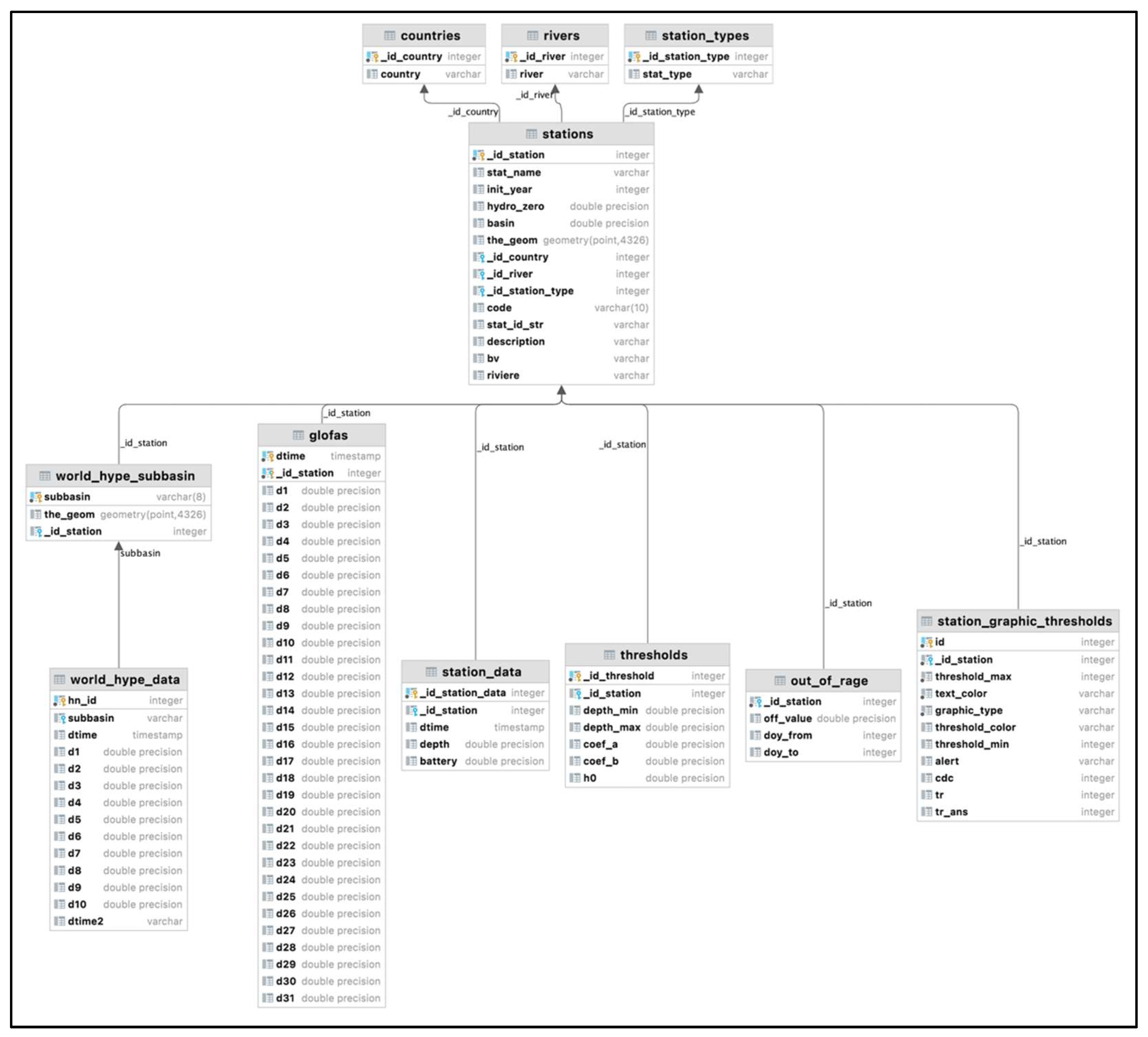
Flood scenarios were calculated through the development of an ad hoc hydraulic numerical model simulating the river’s behavior for each discharge threshold in the Hydrologic Engineering Center’s River Analysis System (HEC-RAS) environment. Geographical layers (shape files) of four-color class scenarios with the assigned hazard thresholds [37] are included in the geodatabase. They are associated with warning messages and map visualization services. Auxiliary spatial data, useful for a clear and geolocated information, are included in the base map package of the study area and accessible and downloadable from a data catalogue.

2.4.4. Data Model

The conceptual design of the SLAPIS geodatabase is based on the entity-relation model defined through a participatory process with local partners involved in data collection and analysis. Data specifications, in terms of format, semantics, geographic references, and metadata have been defined to be adaptive and complementary in terms of data source and processing products.
UML (Unified Modeling Language), the language adopted in the ISO TC/211 context for geomatic data description, has been used for formal dataset definition. Figure 3 reports the section of the UML model related to observed and forecasted data. The output of the hydrological models has been linked to Sirba hydrometric stations. The data model has been also enriched with new tables to store WWH model outcomes for seven specific sub-basins, two of them connected with the gauging stations of Bossey Bangou and Garbey Kourou. The adoption of an application schema allowed us to update, modify, and easily integrate the geodatabase during the different phases of the research project. Moreover UML is platform independent, and can facilitate the implementation procedures of a physical database.

2.5. System Implementation and Software Components

The SLAPIS client−server architecture is based on several open source technologies and software components:
  • PostgreSQL and PostGIS engine is the main component of the information management service layer. It is the system core for managing the geodatabase, geo-processing routines, and procedures.
  • J2EE (Java 2 Enterprise Edition) and JAX-RS technologies are used for API (application programming interface) implementation, allowing the communication with other components and enhancing the interoperability with external clients and services.
  • PHP/AJAX and OpenLayers technologies allow the web application to supply a custom graphical user interface (GUI) for data retrieval (observed and forecast) and map viewing.
  • CKAN (Comprehensive Knowledge Archive Network) software [54] https://ckan.org/ (accessed on 22 September 2021) is used in order to implement the open source data catalogue following the OGC guidelines.
A data and application server and a web server are the hardware components of the Sirba EWS spatial data infrastructure. Through the HTTP protocol, a web browser client can access the web server and SLAPIS GUI, which interact with the application and data server using web services components.

2.5.1. Information Management Services: Data Retrieval and Storage

The geodatabase represents the core of the SLAPIS infrastructure, and is used for managing both collected and calculated data and for improving data search operations.
For managing observed and forecast data, specific procedures have been developed using a mashed-up language:
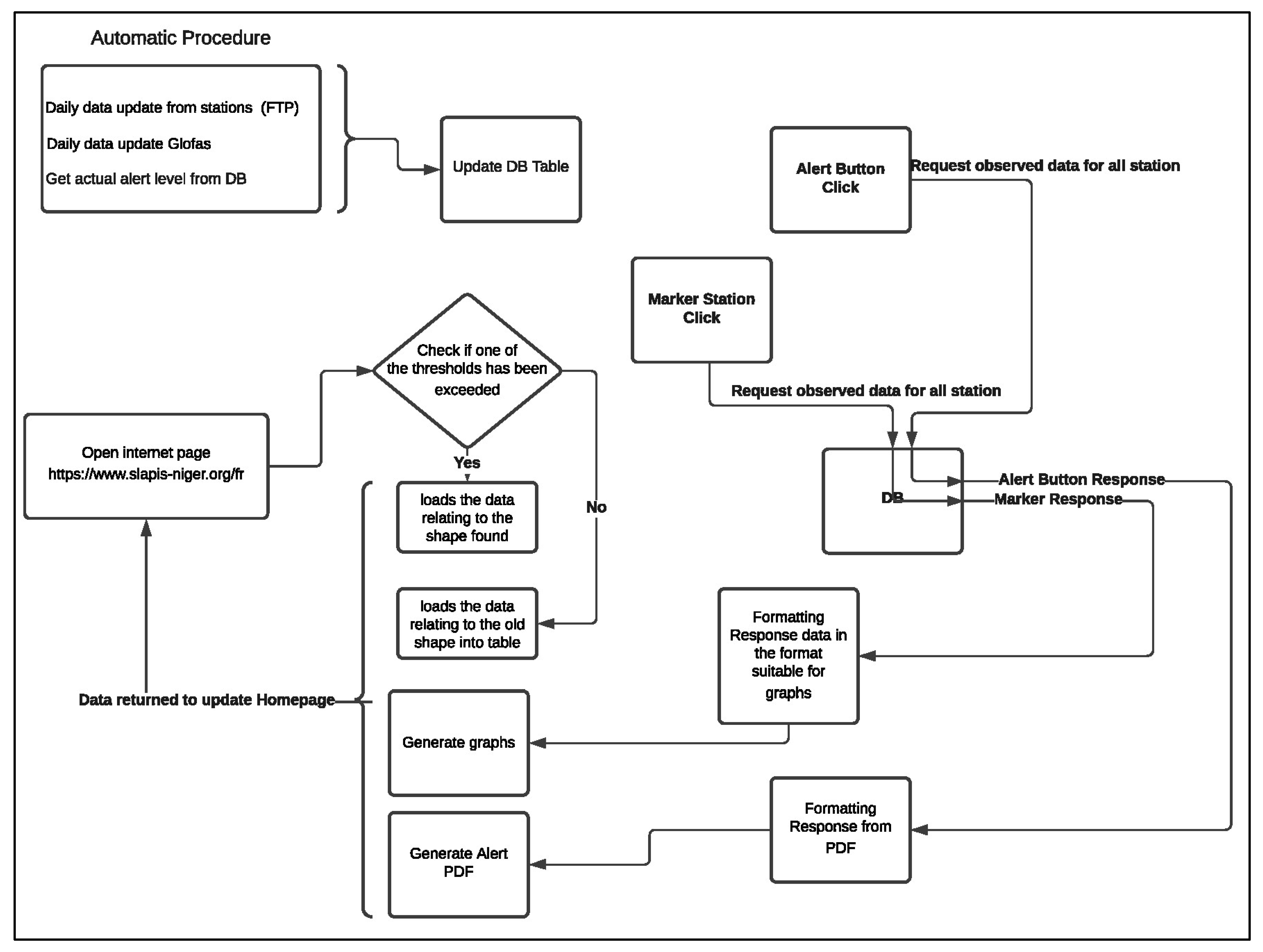
  • Bash scripts for contacting provider servers and downloading raw data;
  • J2EE services for pre-processing and storing downloaded data;
  • PL/pgSQL (Procedural Language/PostgreSQL Structured Query Language) procedures for forecast data optimization (Figure 4).
Bash scripts are used for triggering the downloading and importation of data automatically from forecast providers and hydrological stations.
Concerning hydrological forecast data, following the specifications of the data providers, an automatic procedure has been developed using J2EE technology and integrating OpenSearch engine to download and store forecasts into the geodatabase every day [53]. The forecasts’ optimization procedures specific to WWH [53] and GloFAS [51], developed inside the SLAPIS database, are exposed through a REST web service developed with JAX-RS and J2EE technologies.
Observed data, from hydrological stations, are supplied by the sFTP site and downloaded through a PHP procedure that checks for the presence of new data.
In order to handle missing data issues from hydrological stations, the specific REST service is implemented, allowing experts to check and write them manually.
The REST web services are used to show and plot optimized forecasts through the client graphical user interface. WWH forecasts are available only for profiled users (e.g., operational hydrologists, ANADIA2 partners or scientists), while GloFAS forecasts are published without restrictions. All data are also accessible by CKAN, the web catalogue service of the SLAPIS web platform or using APIs for users with more advanced informatic skills.

2.5.2. Processing Services: SLAPIS Hydrological Web Services

The SLAPIS architecture takes advantage of web services, developed using J2EE, JAX-RS and PHP technologies, to meet the SOA specifications guaranteeing the interoperability between its components and other systems [44].
Web services are composed of two main categories:
  • External services that can be called by clients and other systems. These services are used to create a public information level on the hydrological scenario, flood scenario, and hydrometrics stations, allowing different stakeholders to monitor the evolution of hydrological season in real time.
  • Internal services that are used for backend processing and are independent from a specific platform or implementation.
The main web services implemented in the SLAPIS architecture are synthetically reported in Table 3.

2.5.3. Application Services

Once data and metadata are stored, published, and accessible through interoperable web services, the development of tailored web applications is greatly facilitated and can answer users’ needs [28]. The WebApp represents one of the most important components of the SLAPIS system, allowing the interactions between data providers, processing procedures and end users. Moreover, the SLAPIS WebApp is cross-platform, usable on both desktop and mobile devices.
The application is built on three main user profiles and operational use: generic public user, profiled user, and system administrator. Depending on users’ requirements, it allows generating different dynamic and interactive views (e.g., in the form of graphs or maps) of the same dataset. The user functional diagram (Figure 5) was defined before the implementation process to improve workflow within the system. It helps to define how users may access different views in term of data visualization (maps, graphs, tables, bulletins,) and access to data and services.

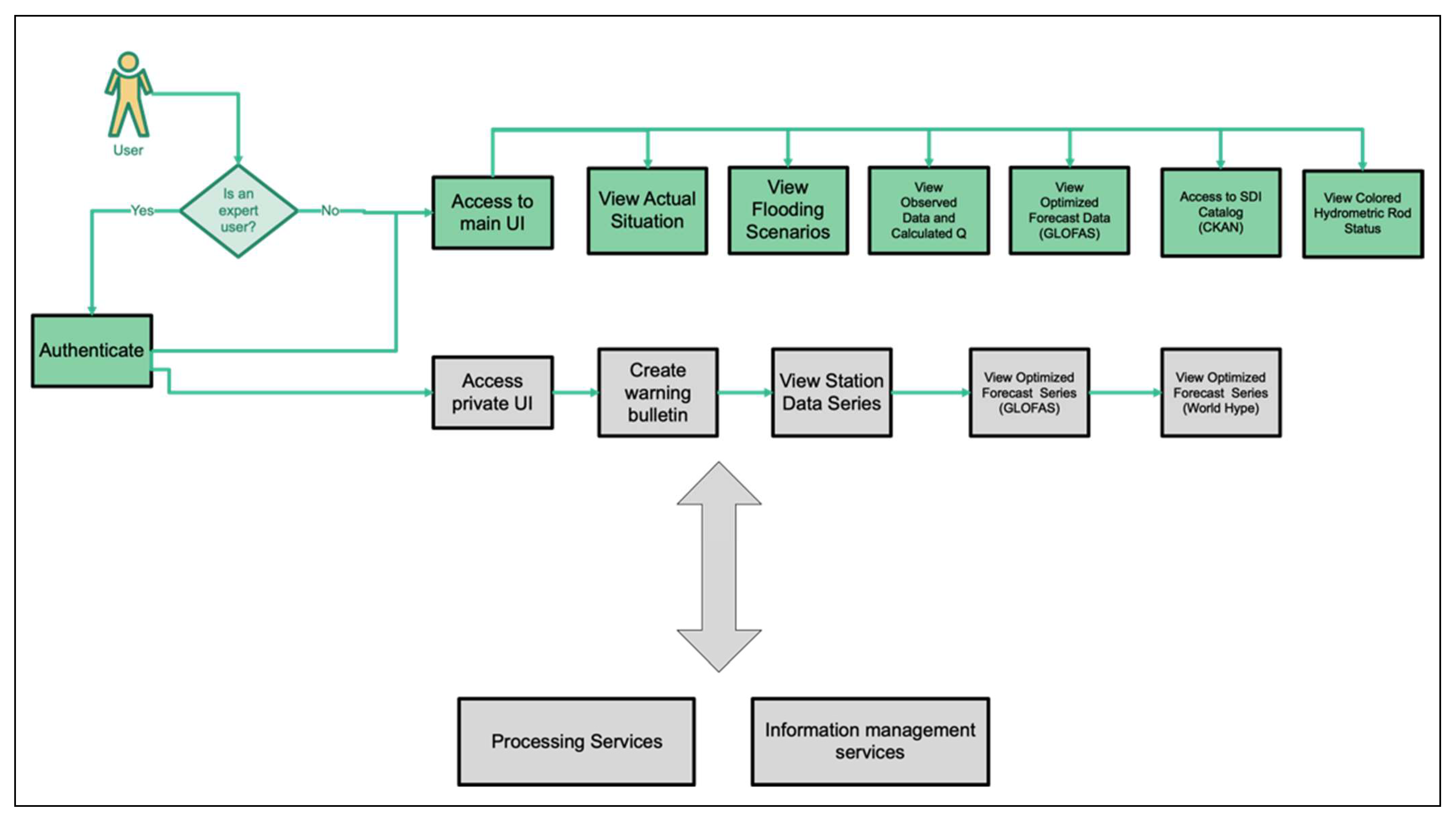
2.5.4. Client: User Access Portal

The user access portal component provides the interface to the final users and the system operators. This component also implements a set of common services used by the other system components, such as authentication, monitoring, and communication tools. The user access portal component implements the required functionalities of “public access portal”, “operator interface”, and “metadata catalogue interface”. The service interface is connected to the information management services component to provide information about the data resources required for a given processing service.
The GUI was designed and implemented for monitoring in real time the observed and forecasted data and their visualization in graphic and tabular formats [23]. The customized functions allow the users to retrieve from the GUI the entire dataset for further analysis or applications. SLAPIS is linked also to an open data portal which, using the CKAN as open-source data catalogue, allows access to the available data, including raw and intermediate research data, as well as complementary studies on the area. Each dataset record in CKAN contains a description of the data and other useful information, such as available formats, the producer and if they are freely available, and which topics they deal with.

3. Results

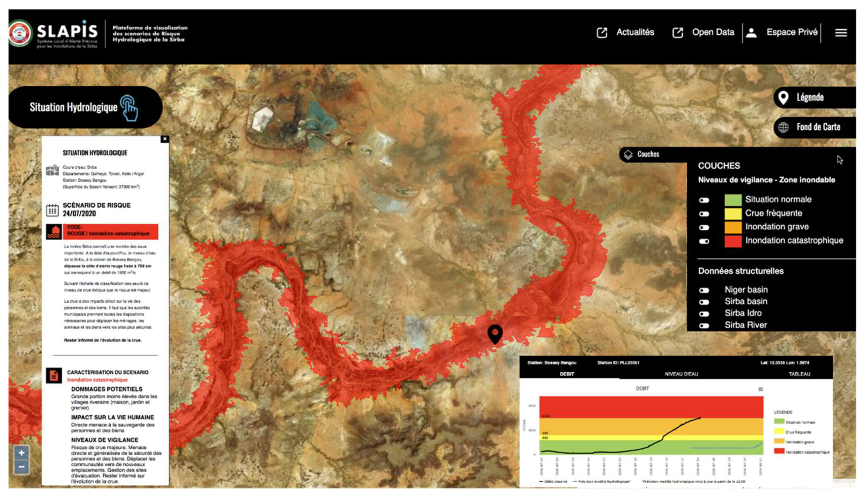
Operational Functionalities

SLAPIS is a fully operational platform used by NHS since 2019, designed and developed via the ANADIA 2.0 project to support operational flood early warning activities in Niger. After three hydrological campaigns of application and testing, the SLAPIS web platform offers nowadays the experience of a complete and flexible use of information within an environment compliant with international standards (OGC and ISO categories).
The core capabilities are synthetically described in Table 4.
The user web interface presents very simple functionalities tailored on the users’ requirements to support flood monitoring and production of scientific and robust local EW advices. The content of the web application is generated dynamically on the server side by retrieval of appropriate information from the database, which is continuously updated. The flow chart (Figure 6) reports how the information is generated and updated automatically by opening the application home page.
The information available through the web interface concerns the overview of hydrological situation, quasi-real-time observed data visualization (graphs and tables), metadata of hydrometric stations, flood scenarios, and auxiliary spatial data (e.g., Sirba basin, hydrography, stations, Niger basin). The interface (Figure 7) is based on an Open Street base map, interchangeable with Bing satellite or Thunderforest.
To avoid any language barrier, which could prevent more comprehensive use of the web application, the interface is available in French, the official language of the target country. The platform is conceived also to foster knowledge sharing. Download data functionality, limited to data that are visualized, is available for each station. The hamburger menu and the open data interface ensure access to all documents, reports, scientific publications, data, and related metadata produced during the whole life cycle of ANADIA 2.0 project activities (Figure 8).
The web application also includes a private section (Figure 9), reserved for profiled and authorized users. Functionalities co-designed with the NHS facilitate the local operators in exploring the whole dataset of each hydrometric station, and in accessing GloFAS and WWH forecasts for deeper analysis.
These web services are oriented to support the operational use of the EWS in creating automatic bulletins for each defined alert threshold. Information on data discharge, hydrological forecast, hydrological trends, and potential damage are automatically embedded, in graph and tabular format, within the bulletin. The operators can edit the bulletin with supplementary comments and advice as well as send it directly from the platform to stakeholders involved in the warning chain of communication.
The WebApp is also linked directly with the Sirba Floods Blog (Actualités) on the ANADIA2 web page https://climateservices.it/sirba-saison-2021-updates/ (accessed on 22 September 2021). The blog is easily accessible from the WebApp and collects SLAPIS bulletins, other information, technical notes, and news on the hydrological season as well as podcasts and video documentation uploaded by local observers.
During the 2019 season the system performance was deeply analyzed in relation to hydrological forecasts and the optimization process applied to different model settings. The results show that the optimization improved the performances of GloFAS 1.0 and GloFAS 2.0. The optimized GloFAS 2.0 demonstrated a substantial improvement in forecast accuracy and a performance suitable for EWS applications [51]. Even in the case of the WWH model, the optimized predictions demonstrated a higher level of accuracy than the original products. On the other hand, WWH has shown a problem of discontinuity in the provision of forecasts and for this reason WWH is used only in internal mode and not public [53].
In 2020, the system was really stressed because of the three flood peaks that occurred in July, August, and September, reaching water levels never touched before. In fact, while the two seasons of 2019 and 2021 were wet, and the Sirba did not pose a critical threat to local communities, the 2020 season was exceptionally abundant, recording the historical observed maximum on the river [9].
The performance analysis of the hydraulic model in a high discharge situation showed overestimation of the flows at Garbey Kourou downstream gauging station and underestimated the lag time from the upstream station. The analysis of the flood hydrographs showed a phase shift and a reduction of peaks between the upstream and downstream hydrometers. Therefore, the hydraulic model was upgraded to improve the lamination and phase shift modeling. Moreover, the quantitative performance of system operation in 2020 showed a complete dataset creation from Garbey Korou hydrometric station and a good performance in hourly data transmission (Table 5). In contrast, the Bossey Bangou dataset consistency (about 80%) and the delay of FTP data transmission (Table 6) reflect the station’s technical problems during the flood peaks and the difficulties NHS technical operators had in making repairs securely and in time. GloFAS forecasts downloaded for both stations showed an optimal performance of the web services implemented following the technical specification of data providers. Contrarywise, the WWH forecasts presented discontinuity because of changes in model settings and in specifications for data access. Therefore, this low operating performance confirmed the choice to limit the access to WWH data to only the platform private area.
Moreover, in 2020, the potential of SLAPIS for flood warning on the Sirba River was fully demonstrated. From July through September the Sirba was consistently above the yellow vigilance threshold with three peaks above the red threshold.
During the monitoring season, SLAPIS generated 18 automatic advices regarding flood risk threshold changes from 19 July 2020 to 23 September 2020. The different flooding scenarios and temporal persistence detected from Garbey Kouru and Bossey Bangou observed data are summarized by Table 7.
Figure 10 presents the total information produced by SLAPIS during the 2020 hydrological season on the Sirba, while Table 8 shows the totals of the different products issued by month. The 1-day weather forecasts have been produced throughout the year. They are normally issued twice a day. When the yellow threshold was exceeded, SLAPIS activated customized services to produce information products for different stakeholders. During the exceptional 2020 season, 22 SLAPIS bulletins were automatically produced and integrated by local authorities to give institutional warnings. The bulletins were accompanied by 3-day weather forecasts used to complement the hydrological/hydraulic forecasts. Automatic bulletins represent an easy communication tool and allow presentation quickly of complex scientific information to decision-makers. In fact, data analysis and routine interactions require time, effort, and skillsets that are not always ensured by NMHS personnel during emergency periods.
In addition, information notes addressed to the technical and scientific community were produced to explain the flood trend and dynamics. Finally, posts and news informed citizens and a wide range of people on the risk scenario of the Sirba River and the precautions to adopt.
SLAPIS is fully integrated into the national alert system [23] and the DGRE issued three national alerts in 2020; information produced in the framework of SLAPIS and the related warnings on the level of vigilance are accessible to different stakeholders with specific tools. The communication and dissemination plan of SLAPIS was defined through users’ consultation in identifying for each user the preferred communication channel and format. Subsequently, SLAPIS warnings were transformed into alerts by the competent institution according to the National Alert Code [23].

4. Discussion

In many cases, relevant data on hydroclimatic risks collected in LDCs (least developed countries) by intergovernmental and non-governmental organizations, university institutes, research organizations, projects, and programs funded by national and international institutions are often not shared in an interoperable way for further usage. The SLAPIS hydrological web service demonstrates that sharing data, knowledge, and tools in the poorest area of the world, where international cooperation is active, is essential for increasing local capacity in response to extreme events and for enhancing the synergies among monitoring systems at different scales. Furthermore, promoting open science practices and adopting a data policy to access data or other results as open as possible [55] can be of great value to the entire international scientific community in advancing hydrological studies in those basins not well monitored. Not least, open access to data and information is recognized in both developed and LDCs as essential in public emergency events such as floods [56].

4.1. Interoperability of Hydrological Services

The SLAPIS hydrological service has been developed integrating past hydrological scenarios to define the risk threshold based on potential impacts, real-time observations to activate the EWS alert chain, and short-term forecasts. SLAPIS demonstrates how a mashup of products from global or regional climate services (GloFAS and WWH forecasts), real-time observations, and weather services can be used efficiently within a general framework based on interoperable web services. The advantages of a flexible infrastructure and a well-structured geodatabase allow the service to be easily updated and further expanded.
The main requirements considered in developing an operational hydrological service in the framework of CBEWS were: open data, interoperability, flexibility, scalability, responsiveness, and specific user needs [23]. For this reason, we adopted a user-oriented architecture focused on the best use of hydrological data for flood monitoring and forecasting and their translation into information useful for the decision-making process. Indeed, delivering hydrological services using interoperable web services can lower the barriers for both data providers and data users. In particular, it enhances the reusability of data and components in various applications, and gives increased return on investment [28]. In the context of early warning and flood risk management, the effectiveness of the services is driven by the rapid availability of data. The coordination between services providers and data sharing can significantly reduce response time. On the other hand, flood monitoring and forecasting results are only partially useful if not connected to potential impacts. According to WMO [57], an EWS should be built on impact-based forecasting and warning services, linking forecast information to decision-relevant impact thresholds for users [58]. From this perspective, the SLAPIS platform connects hydrological thresholds with geographic layers of different flood scenarios based on hydraulic modeling and receptors identified on the field [59].
An example of interoperability effectiveness of the SLAPIS web service was during the 2020 flood when it was used to support the flood early warning system for Niamey City http://35.180.216.160/niamey/ (accessed on 10 September 2021). During the hydrological season of 2020, the Niger River in Niamey reached its uppermost water levels, causing large floods that affected thousands of people and generated damages worth billions of CFA (Financial Community of Africa) francs. The Niamey EWS was not operational because of lack of input real-time hydrological observations. Therefore, the Niamey hydrological gauging station was integrated on the fly into SLAPIS and a webservice was created to supplement real-time data for the Niamey EWS [60].
When a database is implemented, one of the main critical aspects is the update process over time for taking into account the new findings. The SLAPIS data model and related web services approach allow an easy dataset update. Changing the service that applies to the new discharge equation on observed water level data, the discharge data are automatically updated when the query on Q (discharge) values is invocated by the system or by the user. Operationally, gauging measures during the 2020 flood, coupled to other measures during past 5 years, allowed updates of the rating curves of the hydrometric stations (including Niamey) and the equation was implemented in the SLAPIS data model. Therefore, updated discharge measures, calculated from water levels, are actually available in quasi-real-time on the SLAPIS web platform at https://www.slapis-niger.org (accessed on 22 September 2021).

4.2. Dissemination

The three flood peaks of the Sirba in 2020 caused major damage to infrastructure, homes and people’s property; on the other hand, no fatalities were recorded. Indeed, relevant and timely advice and warnings empowered communities’ preparedness and response capacities. Even if an early warning system cannot secure infrastructure, real estate, and crop fields, moveable assets, cattle, and human lives could be saved. This was achieved because the information and communication mechanism put in place by SLAPIS worked very well, even if it was the first time it was tested in operation during an emergency. It was centered on the NHS, which maintained direct contact with the authorities at the central level (Directorate General of Civil Protection and the Ministry of Humanitarian Affairs) and with the local authorities (Mayors of the municipalities of Gotheye, Namaro, Torodi, and Niamey). At the local level, the mayors have been in direct contact with the village chiefs, customary and religious authorities to inform and alert the population, according to the plan drawn up during the implementation of SLAPIS [59]. In this sense, SLAPIS observers also played a very important role disseminating the information they collected and received from other observers and through SLAPIS. The use of smartphones and instant messaging applications greatly aided the communication process.

4.3. Challenges and Limits

One of the major challenges to the development of operational hydrological services in sub-Saharan Africa is the limited technical capacity of NHSs due to their structural weakness [61] and lack of trained and prepared staff [13], and finally limited knowledge of available resources (models, data, web services) and how they can be reused [62]. The case study presented shows how collaboration between the NHS and research institutions can allow for adequate technical and scientific capacity building and ensuring operational technical assistance.
Another challenge of hydrological flood services in developing countries is the lead time, which should be appropriate for preparedness and response actions [63]. In the case of SLAPIS, thours to 10 days [51]. In addition, the interoperability of hydrological services overcomes the limited ability of NHSs to develop and manage distributed hydrological models for flood forecasting.
Nevertheless, the use of large-scale hydrologic information (such as that produced by WWH and GloFAS models) could be misleading [64] because it is not calibrated at the local level [51]. Hence the need for downscaling, calibration, and adaptation of hydrological model products [53] and assimilation of observed data in near-real time. The hydrological observation network in West Africa has progressively degraded during the past 20 years, partly due to insecurity in rural areas and lack of maintenance. On the other hand, hydrological services need near-real-time observed data for both model calibration and validation [65]. Therefore, it is important for NHSs to define a strategy for even minimal maintenance of automatic stations, involving the communities where these stations are installed in basic maintenance and surveillance. Involving communities from the beginning of the service design is an element of sustainability and effectiveness, as widely described by the co-development theory of climate services [66]. In this specific case, involving communities in the hydrological observations and thus in the production of the service helps to strengthen their trust. Trust is an essential element for service uptake and it can also be strengthened with an iterative social learning process [67] using contextually appropriate tools and models, such as roving seminars on weather and floods [23]. Finally, to be able to link observations, hydrological, and hydraulic forecasts to expected impacts, as recommended by the WMO [25] to improve uptake and effectiveness of decision-relevant advice [58], SLAPIS uses pre-processed flood-risk scenarios [37] automatically linked to hydrological threshold by the services implemented in the SLAPIS data infrastructure.
SLAPIS’s main limit is that it covers only on the Sirba reach in Niger because of the lack of real-time hydrological monitoring upstream in Burkina Faso. Therefore, the observation at the Bossey Bangou gauging station limits the lead time of the hydraulic model.
The operational tests also showed some technical weaknesses of the system. The main technical problem, although well known in the Sahel countries, was due to data transfer interruption from stations in extreme conditions such as during the 2020 season. To overcome these disruptions, an internal alert system for administrators and local technicians was fundamental as well as sound previous training on automatic stations maintenance. Consequently, problems were encountered in the observations’ quality and solutions have been set up for checking the integrity of the dataset. Although in recent years internet connection was expanded to a large part of the West Africa countries [68], interruptions in data transmission were also due to unstable internet connection. On the other hand, problems have been experienced also in the continuity of hydrological forecast production. While GloFAS ensures a very high integrity percentage, WWH has high levels of missing data, resulting in a low operational capacity [53]. Finally, the operational maintenance of SLAPIS services had to deal with the update of new versions of global and regional hydrological models. For example, during the three years of testing, GloFAS changed from 2.1 and 2.2 to finally 3.1 in 2021 [69,70], changes that have been easily managed thanks to the data processing services and the flexible data model adopted. It is also important to underline that the developers of forecast models took advantage of the interoperable API services https://www.slapis-niger.org/fr/pag_geoservices (accessed on 22 September 2021) to assimilate Sirba hydrological station data and improve the models’ outputs.

5. Conclusions

Within SLAPIS EWS, the hydrological web services were implemented for quasi-real-time monitoring, prediction, and warning on hydrological-related risks. The SLAPIS system and web services enable the management and visualization of observations and forecast, essential to the preparedness and monitoring phase, and integrate this information in dedicated tools for warning communication to the competent institutions within the national alert system in Niger. Through its web services and multiple communication channels, SLAPIS also provides data and information to other stakeholders, the scientific community, and wider public. The system can be used in quasi-real time, but also in differential time for study of historical events or forecasting.
The usefulness of the platform has been proved during the extreme 2020 season [71,72]. It was demonstrated to be a flexible and robust tool to support operational activities of the NHS. The SLAPIS platform was built to emphasize the importance of improving delivery services, to advance scientific research and applications in basins less monitored or equipped, as well as developing technologies, strengthening capacities, partnerships, and good governance. Achieved results stimulated the interest of local [73] and foreign stakeholders [74], promoting further international cooperation initiatives and transnational basin applications. Some best practices have been recognized in SLAPIS: the sharing of updated quasi-real-time information [75], an efficient communication that flows in both directions, and an effective use of resources.
This study demonstrates the importance of interoperability in distributed hydrometeorological services, promoting collaborative action to facilitate further data and webservice usage. In the context of a weak NHS [61], interoperability and open data access avoids duplicating models and saving resources to be invested in downscaling and calibrating of those already operating in the basin. This approach is coherent with the latest international collaborative strategies, among which the GEOGLOWS initiative, which in collaboration within NHSs of Nepal, Bangladesh, the Dominican Republic, Argentina, and Colombia applied the GloFAS global model to supplement hydrological forecasts for decision-making at a national level [76]. It demands developing NHS technical capacities through training programs and continuous learning building the required skills to cope with the hydrological web services’ innovation, modernization, and sustainability.
Moreover, established cooperation between various categories of researchers and professionals, disaster managers, public officers, technicians, volunteers, even the wider public is a step toward integrated water risk management [12]. Open data, models, open- source software, web services, and information sharing has greatly contributed to expanding the knowledge of flood risk, informing decision-making and increasing flood resilience at local scale in remote less monitored hydrological basins. Lessons learnt highlight that strengthening capacities of NHSs and empowering communities in flood early warning are two facets of service sustainability. The knowledge transfer relies on an iterative model of social learning [67] establishing long-term relationships and trust among the different actors of the service.

Author Contributions

Conceptualization: Vieri Tarchiani, Tiziana De Filippis, Giovanni Massazza, Maurizio Rosso, Alessandro Pezzoli; Methodology: Tiziana De Filippis, Vieri Tarchiani, Leandro Rocchi, Giovanni Massazza; Developing: Leandro Rocchi, Tiziana De Filippis, Giovanni Massazza; Validation: Leandro Rocchi, Giovanni Massazza, Vieri Tarchiani, Alessandro Pezzoli; Investigation: Giovanni Massazza, Vieri Tarchiani, Mohamed Housseini Ibrahim; Writing—original draft preparation: Tiziana De Filippis, Vieri Tarchiani; Writing—review and editing: Vieri Tarchiani, Tiziana De Filippis, Leandro Rocchi, Maurizio Rosso, Alessandro Pezzoli, Giovanni Massazza; Funding acquisition: Vieri Tarchiani. All authors have read and agreed to the published version of the manuscript.

Funding

This research was co-funded by the Italian Agency for Development Cooperation within the ANADIA2 Project [AID 010848] implemented by the Institute of Bioeconomy (IBE)-National Research Council of Italy (CNR) at Florence in collaboration with the National Directorate for Meteorology of Niger (DMN), and by the Interuniversity Department of Regional and Urban Studies and Planning (DIST)-Politecnico and University of Turin.

Institutional Review Board Statement

Not applicable.

Informed Consent Statement

Not applicable.

Data Availability Statement

Data cited by this paper are available through SLAPIS data catalogue at http://sdicatalog.fi.ibimet.cnr.it:5003/fr/dataset?groups=slapis_prj (accessed on 20 December 2021). Slapis WebApp backend code, doi:10.5281/zenodo.5793259 and frontend code doi:10.5281/zenodo.5793239 are available on the public software repository GitHub https://zenodo.org/record/5793259#.YcRimyzSKLc (accessed on 20 December 2021).

Acknowledgments

The Authors thank Gaptia Lawan Katiellou, Director of the National Meteorological Service of Niger, for his engagement and mindfulness and Bruno Guerzoni and Elena Rapisardi for their support in front-end development and GUI design.

Conflicts of Interest

The authors declare no conflict of interest. The funders had no role in the design of the study; in the collection, analyses, or interpretation of data; in the writing of the manuscript, or in the decision to publish the results.

References

  1. European Commission, Joint Research Centre; De Groeve, T.; Revilla-Romero, B.; Pappenberger, F.; Salamon, P.; Thiemig, V.; Thielen-del Pozo, J.; Hirpa, F. The Benefit of Continental Flood Early Warning Systems to Reduce the Impact of Flood Disasters; European Union Publications Office: Luxembourg, 2016. [Google Scholar]
  2. Bakker, M.H.N. Transboundary river floods: Examining countries, international river basins and continents. Water Policy 2009, 11, 269–288. [Google Scholar] [CrossRef]
  3. Tarhule, A. Damaging rainfall and flooding: The other Sahel hazards. Clim. Chang. 2005, 72, 355–377. [Google Scholar] [CrossRef]
  4. Thiemig, V.; de Roo, A.; Gadain, H. Current status on flood forecasting and early warning in Africa. Int. J. River Basin Manag. 2011, 9, 63–78. [Google Scholar] [CrossRef]
  5. Fiorillo, E.; Crisci, A.; Issa, H.; Maracchi, G.; Morabito, M.; Tarchiani, V. Recent Changes of Floods and Related Impacts in Niger Based on the ANADIA Niger Flood Database. Climate 2018, 6, 59. [Google Scholar] [CrossRef] [Green Version]
  6. Tazen, F.; Diarra, A.; Kabore, R.F.W.; Ibrahim, B.; Bologo/Traoré, M.; Traoré, K.; Karambiri, H. Trends in flood events and their relationship to extreme rainfall in an urban area of Sahelian West Africa: The case study of Ouagadougou, Burkina Faso. J. Flood Risk Manag. 2019, 12, e12507. [Google Scholar] [CrossRef] [Green Version]
  7. Descroix, L.; Genthon, P.; Amogu, O.; Rajot, J.-L.; Sighomnou, D.; Vauclin, M. Change in Sahelian Rivers hydrograph: The case of recent red floods of the Niger River in the Niamey region. Glob. Planet. Chang. 2012, 98–99, 18–30. [Google Scholar] [CrossRef]
  8. Aich, V.; Liersch, S.; Vetter, T.; Andersson, J.; Müller, E.; Hattermann, F. Climate or Land Use?—Attribution of Changes in River Flooding in the Sahel Zone. Water 2015, 7, 2796–2820. [Google Scholar] [CrossRef]
  9. Massazza, G.; Bacci, M.; Descroix, L.; Ibrahim, M.H.; Fiorillo, E.; Katiellou, G.L.; Panthou, G.; Pezzoli, A.; Rosso, M.; Sauzedde, E.; et al. Recent Changes in Hydroclimatic Patterns over Medium Niger River Basins at the Origin of the 2020 Flood in Niamey (Niger). Water 2021, 13, 1659. [Google Scholar] [CrossRef]
  10. Beniston, M.; Stoffel, M.; Harding, R.; Kernan, M.; Ludwig, R.; Moors, E.; Samuels, P.; Tockner, K. Obstacles to data access for research related to climate and water: Implications for science and EU policy-making. Environ. Sci. Policy 2012, 17, 41–48. [Google Scholar] [CrossRef] [Green Version]
  11. Ames, D.P.; Horsburgh, J.S.; Cao, Y.; Kadlec, J.; Whiteaker, T.; Valentine, D. HydroDesktop: Web services-based software for hydrologic data discovery, download, visualization, and analysis. Environ. Model. Softw. 2012, 37, 146–156. [Google Scholar] [CrossRef]
  12. Spiekermann, R.; Kienberger, S.; Norton, J.; Briones, F.; Weichselgartner, J. The Disaster-Knowledge Matrix—Reframing and evaluating the knowledge challenges in disaster risk reduction. Int. J. Disaster Risk Reduct. 2015, 13, 96–108. [Google Scholar] [CrossRef] [Green Version]
  13. WMO. Status of Human Resources in National Meteorological and Hydrological Services, ETR-21. 2017. Available online: https://library.wmo.int/doc_num.php?explnum_id=4184 (accessed on 20 December 2021).
  14. WMO. State of Climate Services: Water, WMO Report No. 1278, 2021; WMO: Geneva, Switzerland, 2021; p. 46. Available online: https://library.wmo.int/index.php?lvl=notice_display&id=21963 (accessed on 20 December 2021).
  15. World Bank, GFDRR. The State of Hydrological Services in Developing Countries. 2018. Available online: https://www.gfdrr.org/sites/default/files/publication/state-of-hydrological-services_web.pdf (accessed on 20 December 2021).
  16. Changnon, D. Improving Outreach in Atmospheric Sciences: Assessment of Users of Climate Products. Bull. Am. Meteorol. Soc. 2004, 85, 601–606. [Google Scholar] [CrossRef]
  17. Vaughan, C.; Dessai, S. Climate services for society: Origins, institutional arrangements, and design elements for an evaluation framework: Climate services for society. Wiley Interdiscip. Rev. Clim. Chang. 2014, 5, 587–603. [Google Scholar] [CrossRef] [PubMed]
  18. Vincent, K.; Daly, M.; Scannell, C.; Leathes, B. What can climate services learn from theory and practice of co-production? Clim. Serv. 2018, 12, 48–58. [Google Scholar] [CrossRef]
  19. Balla, D.; Zichar, M.; Kiss, E.; Szabó, G.; Mester, T. Possibilities for Assessment and Geovisualization of Spatial and Temporal Water Quality Data Using a WebGIS Application. ISPRS Int. J. Geo-Inf. 2022, 11, 108. [Google Scholar] [CrossRef]
  20. Santoro, M.; Andres, V.; Jirka, S.; Koike, T.; Looser, U.; Nativi, S.; Pappenberger, F.; Schlummer, M.; Strauch, A.; Utech, M.; et al. Interoperability challenges in river discharge modelling: A cross domain application scenario. Comput. Geosci. 2018, 115, 66–74. [Google Scholar] [CrossRef]
  21. Gautam, D.K.; Phaiju, A.G. Community Based Approach to Flood Early Warning in West Rapti River Basin of Nepal. J. Integr. Disaster Risk Manag. 2013, 3, 155–169. [Google Scholar] [CrossRef]
  22. Zia, A.; Wagner, C.H. Mainstreaming Early Warning Systems in Development and Planning Processes: Multilevel Implementation of Sendai Framework in Indus and Sahel. Int. J. Disaster Risk Sci. 2015, 6, 189–199. [Google Scholar] [CrossRef] [Green Version]
  23. Tarchiani, V.; Massazza, G.; Rosso, M.; Tiepolo, M.; Pezzoli, A.; Ibrahim, M.H.; Katiellou, G.L.; Tamagnone, P.; De Filippis, T.; Rocchi, L.; et al. Community and impact based early warning system for flood risk preparedness: The experience of the Sirba river in Niger. Sustainability 2020, 12, 1802. [Google Scholar] [CrossRef] [Green Version]
  24. Butts, M.; Klinting, A.; Ivan, M.; Larsen, J.; Brandt, J.; Price, D. A Flood Forecasting System: Integrating Web, Gis and modelling technology. In Proceedings of the 26th Annual ESRI International User Conference, San Diego Convention Center, San Diego, CA, USA, 7–11 August 2006; pp. 1–10. Available online: https://proceedings.esri.com/library/userconf/proc06/papers/papers/pap_1305.pdf (accessed on 6 December 2021).
  25. WMO. Valuing Weather and Climate: Economic Assessment of Meteorological and Hydrological Services. WMO-No. 1153, 2015. Available online: https://library.wmo.int/doc_num.php?explnum_id=3314 (accessed on 8 November 2021).
  26. Dallery, D.; Squividant, H.; de Lavenne, A.; Launay, J.; Cudennec, C. An end-user-friendly hydrological Web Service for hydrograph prediction in ungauged basins. Hydrol. Sci. J. 2020, Volume 0, 1–9. [Google Scholar] [CrossRef]
  27. WMO. Climate Knowledge for Action: A Global Framework for Climate Services—Empowering the Most Vulnerable. WMO-No. 1066, 2011. Available online: https://library.wmo.int/doc_num.php?explnum_id=7719 (accessed on 12 November 2021).
  28. Giuliani, G.; Nativi, S.; Obregon, A.; Beniston, M.; Lehmann, A. Spatially enabling the Global Framework for Climate Services: Reviewing geospatial solutions to efficiently share and integrate climate data & information. Clim. Serv. 2017, 8, 44–58. [Google Scholar] [CrossRef]
  29. Blöschl, G.; Bierkens, M.F.P.; Chambel, A.; Cudennec, C.; Destouni, G.; Fiori, A.; Kirchner, J.W.; McDonnell, J.J.; Savenije, H.H.; Sivapalan, M.; et al. Twenty-three unsolved problems in hydrology (UPH)—A community perspective. Hydrol. Sci. J. 2019, 64, 1141–1158. [Google Scholar] [CrossRef] [Green Version]
  30. Goodall, J.; Horsburgh, J.; Whiteaker, T.; Maidment, D.; Zaslavsky, I. A first approach to web services for the National Water Information System. Environ. Model. Softw. 2008, 23, 404–411. [Google Scholar] [CrossRef]
  31. Kadlec, J.; Ames, D.P. Design and Development of Web Services for Accessing Free Hydrological Data from the Czech Republic. In Environmental Software Systems. Frameworks of Environment; ISESS 2011, IFIP Advances in Information and Communication Technology; Hřebíček, J., Schimak, G., Denzer, R., Eds.; Springer: Berlin/Heidelberg, Germany, 2011; Volume 359, pp. 581–588. [Google Scholar] [CrossRef] [Green Version]
  32. Bera, R.; Squividant, H.; Le Henaff, G.; Pichelin, P.; Ruiz, L.; Launay, J.; Vanhouteghem, J.; Aurousseau, P.; Cudennec, C. GéoSAS: A modular and interoperable Open Source Spatial Data Infrastructure for research. Proc. Int. Assoc. Hydrol. Sci. 2015, 368, 9–14. [Google Scholar] [CrossRef] [Green Version]
  33. Granell, C.; Díaz, L.; Gould, M. Service-oriented applications for environmental models: Reusable geospatial services. Environ. Model. Softw. 2010, 25, 182–198. [Google Scholar] [CrossRef]
  34. Goodall, J.L.; Saint, K.D.; Ercan, M.B.; Briley, L.J.; Murphy, S.; You, H.; DeLuca, C.; Rood, R.B. Coupling climate and hydrological models: Interoperability through Web Services. Environ. Model. Softw. 2013, 46, 250–259. [Google Scholar] [CrossRef]
  35. Tiepolo, M.; Tarchiani, V. Risque et Adaptation Climatique Dans la Région Tillabéri, Niger; L’Harmattan: Paris, France, 2016; ISBN 978-2-343-08493-0. [Google Scholar]
  36. Tamagnone, P.; Massazza, G.; Pezzoli, A.; Rosso, M. Hydrology of the Sirba River: Updating and analysis of discharge time series. Water Switz. 2019, 11, 156. [Google Scholar] [CrossRef] [Green Version]
  37. Massazza, G.; Tamagnone, P.; Wilcox, C.; Belcore, E.; Pezzoli, A.; Vischel, T.; Panthou, G.; Housseini Ibrahim, M.; Tiepolo, M.; Tarchiani, V.; et al. Flood Hazard Scenarios of the Sirba River (Niger): Evaluation of the Hazard Thresholds and Flooding Areas. Water 2019, 11, 1018. [Google Scholar] [CrossRef] [Green Version]
  38. Descroix, L.; Guichard, F.; Grippa, M.; Lambert, L.A.; Panthou, G.; Mahé, G.; Gal, L.; Dardel, C.; Quantin, G.; Kergoat, L.; et al. Evolution of Surface Hydrology in the Sahelo-Sudanian Strip: An Updated Review. Water 2018, 10, 748. [Google Scholar] [CrossRef] [Green Version]
  39. Aich, V.; Koné, B.; Hattermann, F.F.; Paton, E.N. Time Series Analysis of Floods across the Niger River Basin. Water 2016, 8, 165. [Google Scholar] [CrossRef] [Green Version]
  40. Leblanc, M.; Favreau, G.; Massuel, S.; Tweed, S.O.; Loireau, M.; Cappelaere, B. Land clearance and hydrological change in the Sahel: SW Niger. Glob. Planet. Chang. 2008, 61, 135–150. [Google Scholar] [CrossRef]
  41. Mahé, G.; Paturel, J.-E.; Servat, E.; Conway, D.; Dezetter, A. The impact of land use change on soil water holding capacity and river flow modelling in the Nakambe River, Burkina-Faso. J. Hydrol. 2005, 300, 33–43. [Google Scholar] [CrossRef]
  42. Pastorello, G.Z.; Senra, R.D.A.; Medeiros, C.B. Bridging the gap between geospatial resource providers and model developers. ACM Press. In Proceedings of the 16th ACM SIGSPATIAL International Conference on Advances in Geographic Information Systems2014GIS’08, Irvine, CA, USA, 5–7 November 2008. [Google Scholar] [CrossRef]
  43. Pastorello, G.Z.; Senra, R.D.A.; Medeiros, C.B. A standards-based framework to foster geospatial data and process interoperability. J. Braz. Comput. Soc. 2009, 15, 13–25. [Google Scholar] [CrossRef] [Green Version]
  44. OGC. The OpenGIS Abstract Specification Topic 12: OpenGIS Service Architecture v.4.3. Open Geospatial Consortium, George Percivall, G., Eds.; 2002. Available online: https://www.ogc.org/docs/as (accessed on 20 December 2021).
  45. Seth, A.; Singla, A.R.; Aggarwal, H. Service oriented architecture adoption trends: A critical survey. Commun. Comput. Inf. Sci. 2012, 306, 164–175. [Google Scholar] [CrossRef]
  46. Niknejad, N.; Hussin, A.R.C.; Prasetyo, Y.A.; Ghani, I.; Fajrillah, A.A.N. Service oriented architecture adoption: A systematic review. Int. J. Integr. Eng. 2018, 10, 49–58. [Google Scholar] [CrossRef]
  47. Papazoglou, M.P.; van den Heuvel, W.-J. Service oriented architectures: Approaches, technologies and research issues. VLDB J. 2007, 16, 389–415. [Google Scholar] [CrossRef] [Green Version]
  48. OGC. OpenGIS® Web Services Architecture Description, Version: 0.1.0; Whiteside, A., Ed.; OGC 05-042r2; Open Geospatial Consortium: Wayland, MA, USA, 2005; p. 22. Available online: https://www.ogc.org/docs/bp (accessed on 20 December 2021).
  49. Şahina, K.; Gumusayb, M.U. Service Oriented Architecture (SOA) Based Web Services for Geographic Information Systems. The International Archives of the Photogrammetry, Remote Sensing and Spatial Information Sciences, 2008, Volume 37-B2. Available online: https://www.semanticscholar.org/paper/SERVICE-ORIENTED-ARCHITECTURE-(-SOA-)-BASED-WEB-FOR-%C5%9Eahina-Gumusayb/79b8c99f12edbe5ea118a291e4a7be63874ea935 (accessed on 15 November 2021).
  50. Brunner, M.I.; Slater, L.; Tallaksen, L.M.; Clark, M. Challenges in modeling and predicting floods and droughts: A review. WIREs Water 2021, 8, e1520. [Google Scholar] [CrossRef]
  51. Passerotti, G.; Massazza, G.; Pezzoli, A.; Bigi, V.; Zsótér, E.; Rosso, M. Hydrological model application in the Sirba river: Early warning system and GloFAS improvements. Water 2020, 12, 620. [Google Scholar] [CrossRef] [Green Version]
  52. Arheimer, B.; Pimentel, R.; Isberg, K.; Crochemore, L.; Andersson, J.C.M.; Hasan, A.; Pineda, L. Global catchment modelling using World-Wide HYPE (WWH), open data, and stepwise parameter estimation. Hydrol. Earth Syst. Sci. 2020, 24, 535–559. [Google Scholar] [CrossRef] [Green Version]
  53. Massazza, G.; Tarchiani, V.; Andersson, J.C.M.; Ali, A.; Ibrahim, M.H.; Pezzoli, A.; De Filippis, T.; Rocchi, L.; Minoungou, B.; Gustafsson, D.; et al. Downscaling Regional Hydrological Forecast for Operational Use in Local Early Warning: HYPE Models in the Sirba River. Water 2020, 12, 3504. [Google Scholar] [CrossRef]
  54. CKAN—The Open Source Data Management System. Available online: http://ckan.org/ (accessed on 15 November 2021).
  55. UNESCO. UNESCO Recommendation on Open Science SC-PCB-SPP/2021/OS/UROS. 2021. Available online: https://unesdoc.unesco.org/ark:/48223/pf0000379949 (accessed on 10 January 2022).
  56. Iadanza, C.; Trigila, A.; Starace, P.; Dragoni, A.; Biondo, T.; Roccisano, M. IdroGEO: A Collaborative Web Mapping Application Based on REST API Services and Open Data on Landslides and Floods in Italy. ISPRS Int. J. Geo-Inf. 2021, 10, 89. [Google Scholar] [CrossRef]
  57. WMO. Guidelines on Multi-hazard Impact-based Forecast and Warning Services. 2015. Available online: https://library.wmo.int/doc_num.php?explnum_id=7901 (accessed on 20 December 2021).
  58. Nkiaka, E.; Taylor, A.; Dougill, A.J.; Antwi-Agyei, P.; Fournier, N.; Bosire, E.N.; Konte, O.; Lawal, K.A.; Mutai, B.; Mwangi, E.; et al. Identifying user needs for weather and climate services to enhance resilience to climate shocks in sub-Saharan Africa. Environ. Res. Lett. 2019, 14, 123003. [Google Scholar] [CrossRef]
  59. Tiepolo, M.; Rosso, M.; Massazza, G.; Belcore, E.; Issa, S.; Braccio, S. Flood Assessment for Risk-Informed Planning along the Sirba River, Niger. Sustainability 2019, 11, 4003. [Google Scholar] [CrossRef] [Green Version]
  60. Climate Services Portal. Available online: https://climateservices.it/slapis-contribue-au-systeme-dalerte-aux-inondations-pour-la-ville-de-niamey/ (accessed on 10 January 2022).
  61. Brasseur, G.P.; Gallardo, L. Climate Services: Lessons learned and future prospects. Earth Future 2016, 4, 79–89. [Google Scholar] [CrossRef] [Green Version]
  62. Street, R.B.; Buontempo, C.; Mysiak, J.; Karali, E.; Pulquério, M.; Murray, V.; Swart, R. How could climate services support disaster risk reduction in the 21st century. Int. J. Disast. Risk Reduct. 2019, 34, 28–33. [Google Scholar] [CrossRef]
  63. Smith, P.J.; Brown, S.; Dugar, S. Community-based early warning systems for flood risk mitigation in Nepal. Nat. Hazards Earth Syst. Sci. 2017, 17, 423–437. [Google Scholar] [CrossRef] [Green Version]
  64. Donnelly, C.; Ernst, K.; Arheimera, B. A comparison of hydrological climate services at different scales by users and scientists. Clim. Serv. 2018, 11, 24–35. [Google Scholar] [CrossRef]
  65. Salack, S.; Bossa, A.; Bliefernicht, J.; Berger, S.; Yira, Y.; Sanoussi, K.A.; Guug, S.; Heinzeller, D.; Avocanh, A.S.; Hamadou, B.; et al. Designing Transnational Hydroclimatological Observation Networks and Data Sharing Policies in West Africa. Data Sci. J. 2019, 18, 33. [Google Scholar] [CrossRef]
  66. Kruk, M.C.; Parker, B.; Marra, J.J.; Werner, K.; Heim, R.; Vose, R.; Malsale, P. Engaging with users of climate information and the coproduction of knowledge. Weather Climate Soc. 2017, 9, 839–849. [Google Scholar] [CrossRef]
  67. Bremer, S.; Wardekker, A.; Dessai, S.; Sobolowski, S.; Slaattelid, R.; van der Sluijs, J. Toward a multi-faceted conception of co-production of climate services. Clim. Serv. 2019, 13, 42–50. [Google Scholar] [CrossRef]
  68. Rodríguez-Castelán, C.; Ochoa, R.G.; Lach, S.; Masaki, T. Mobile Internet Adoption in West Africa. In Policy Research Working Paper; No. WPS 9560; World Bank Group: Washington, DC, USA, 2021; Available online: http://documents.worldbank.org/curated/en/878041614611542135/Mobile-Internet-Adoption-in-West-Africa (accessed on 2 December 2021).
  69. Harrigan, S.; Zsoter, E.; Alfieri, L.; Prudhomme, C.; Salamon, P.; Wetterhall, F.; Barnard, C.; Cloke, H.; Pappenberger, F. GloFAS-ERA5 operational global river discharge reanalysis 1979–present. Earth Syst. Sci. Data 2020, 12, 2043–2060. [Google Scholar] [CrossRef]
  70. Copernicus Emergency Management Service—GloFAS v3.1. Available online: https://www.globalfloods.eu/news/92-glofas-v31-pre-release-on-15042021/ (accessed on 10 December 2021).
  71. Sossou, I. Niger: Nouvelle alerte «Rouge» Sur La Montée Des Eaux De La Rivière «Sirba», L’evenement Niger, 14/09/2020. Available online: https://levenementniger.com/niger-nouvelle-alerte-rouge-sur-la-montee-des-eaux-de-la-riviere-sirba (accessed on 20 December 2021).
  72. Soumana, A. Montée des Eaux du Fleuve Niger et de la Sirba: Alerte Rouge Inondations Sur les Rives du Fleuve et des Affluents, le Sahel, 14 August 2020. Available online: http://www.lesahel.org/montee-des-eaux-du-fleuve-niger-et-de-la-sirba-alerte-rouge-inondations-sur-les-rives-du-fleuve-et-des-affluents (accessed on 20 December 2021).
  73. Diallo, M. Séminaire ANADIA 2 Sur La Gestion Du Risque D’Inondation: Présenter Aux Acteurs Le Système Local D’Alerte Précoce Contre Les Inondations De La Sirba (SLAPIS), Le Sahel, 19 May 2021. Available online: https://www.lesahel.org/seminaire-anadia-2-sur-la-gestion-du-risque-dinondation-presenter-aux-acteurs-le-systeme-local-dalerte-precoce-contre-les-inondations-de-la-sirba-slapis (accessed on 20 December 2021).
  74. Copernicus, Operational Review of the Record Flood in Niamey, Niger. Sentinel Vision, EVT-719, 27 August 2020. Available online: https://www.sentinelvision.eu/gallery/html/fab25b31f6064dcf9caf84cc693051af (accessed on 10 January 2022).
  75. MAHGC, Ministère de l’Action Humanitaire et de la Gestion des Catastrophes, Système d’alerte aux Inondations pour la ville de Niamey. Available online: http://35.180.216.160/Niamey/ (accessed on 10 January 2022).
  76. Souffront Alcantara, M.A.; Nelson, E.J.; Shakya, K.; Edwards, C.; Roberts, W.; Krewson, C.; Ames, D.P.; Jones, N.L.; Gutierrez, A. Hydrologic Modeling as a Service (HMaaS): A New Approach to Address Hydroinformatic Challenges in Developing Countries. Front. Environ. Sci. 2019, 7, 158. [Google Scholar] [CrossRef]
Figure 1. SLAPIS study area: the Sirba River Basin with the hydrometric stations, the hydrometric staffs, Sirba River and watershed boundaries. Bottom right: Africa overview with Niger study area.
Ijgi 11 00236 g001
Figure 2. SLAPIS logical service-oriented architecture.
Ijgi 11 00236 g002
Figure 3. SLAPIS observed and forecasted data model.
Ijgi 11 00236 g003
Figure 4. SLAPIS information management services.
Ijgi 11 00236 g004
Figure 5. SLAPIS user functional diagram: WebApp layer.
Ijgi 11 00236 g005
Figure 6. Information flow chart.
Ijgi 11 00236 g006
Figure 7. Web application interface: risk scenario and hydrological threshold reached in July 2020.
Ijgi 11 00236 g007
Figure 8. Web application interface: view of data catalogue and main menu.
Ijgi 11 00236 g008
Figure 9. Private view of the web application: view of dataset analysis functions.
Ijgi 11 00236 g009
Figure 10. Hydrograms of the Sirba at Garbey Kourou (GK) and Bossey Bangou (BB) and information produced during the 2020 hydrological season.
Ijgi 11 00236 g010
Table 1. Sirba hydrometric stations.
Hydrometric StationLat. [°]Lon. [°]RiverCountryBasin (km2)Installation Date
Garbey Korou13.731.6SirbaNiger39.0951956
Bossey Bangou13.351.29SirbaNiger37.2882018
Niamey 113.512.11NigerNiger700.0001929
1 Integrated in the SLAPIS geodatabase in 2020.
Table 2. Colored hydrometric staffs of Sirba River Basin.
Hydrometric Staff/Villages Lat. [°]Lon. [°]RiverMunicipalityInstallation Date
Touré13.611.44SirbaGotheye2019
Larba Birno13.701.55SirbaGotheye2019
Garbey Kourou13.731.60SirbaGotheye2019
Tallé13.761.63SirbaGotheye2019
Larba Toulombo13.691.55SirbaNamaro2019
Table 3. Web services implemented in the SLAPIS web application.
Web ServicesTechnologiesFormat
Import data from hydrometric stations to DBBash, PHPPostgreSQL data
Discharge calculus J2EE, JAX-RSJSON, CSV
Import GloFAS forecast data providerBash, J2EE, JAX-RSPostgreSQL data
GloFAS forecast data optimizationJ2EE, JAX-RS, PL/pgSQL ?JSON, CSV
Import data from World-Wide Hype data providerJ2EE, JAX-RSPostgreSQL data
World-Wide Hype data optimizationJ2EE, JAX-RS, PL/pgSQL ?JSON, CSV
Extract geographic structural layers J2EE-JAX-RS /WMSGeoJSON, SHP
Extract flood scenario layers J2EE-JAX-RS, PostGISGeoJSON, SHP, PNG
Automatic report generator PHPPDF
Data output generatorPHP, J2EE, JAX-RSJSON, CSV, PDF Excel, PNG
Table 4. SLAPIS core capabilities.
CapabilitiesDescription
VisualizationDischarge and water level data/forecast/risk scenario
GeoAnalysis/processingPlanned for the next version
ReportingBulletins: automatic update
Search and discoveryData set, documentations, geographic layer
Alert and notificationsAutomatic internal alert; notification to national/local stakeholders
CollaborationUniversities, research centers, national hydrological Institutions, international cooperation projects
Content managementMetadata and documentation
(in charge of system administrator)
Resource managementResource allocation (in charge of system administrator)
Data managementIn charge of system administrator or
profiled users with API
Decision supportLink to local planning documentation
IT securityConform to CNR and GDPR policy
OtherLink to the reference project ANADIA 2 Blog
Table 5. Garbey Korou station: dataset consistency, performance in FTP file data transmission, and hydrological forecast download.
MonthDataset (Records)Expected
%
FileFTP
(ΔT = 1 h)
Expected
%
GloFAS (Records)Expected
%
WWH
(Records)
Expected
%
Jun72010067794301001653
Jul7441007119631100723
Aug74310063886311002581
Sept72010066492301002273
Table 6. Bossey Bangou station: dataset consistency, performance in FTP data transmission, and forecast download.
Month Dataset (Records)Expected
%
FileFTP
(ΔT = 1 h)
Expected
%
GloFAS (Records)Expected
%
WWH
(Records)
Expected
%
Jun5637839054301001653
Jul7441005777831100723
Aug5607535047311002581
Sept5447630542301002273
Table 7. Number of hours/days the thresholds are exceeded at BB and GK in 2020.
Threshold Q (m3s−1)GK HoursGK DaysBB HoursBB Days
600154064156565
800125152130254
1500001064
Table 8. Information produced by SLAPIS during the 2020 hydrological season by type of information.
Type of InformationJulyAugustSeptemberOctoberTotal
1 day weather forecasts626258 182
3 days weather forecasts101723 50
SLAPIS bulletins895 22
SLAPIS Posts 11169 36
SLAPIS information notes 472114
DGRE National Alert 3 3
Total 95113971307
Publisher’s Note: MDPI stays neutral with regard to jurisdictional claims in published maps and institutional affiliations.

