Earth Observation for Settlement Mapping of Amazonian Indigenous Populations to Support SDG7

 , , and
Abstract
:
1. Introduction
2. Materials and Methods
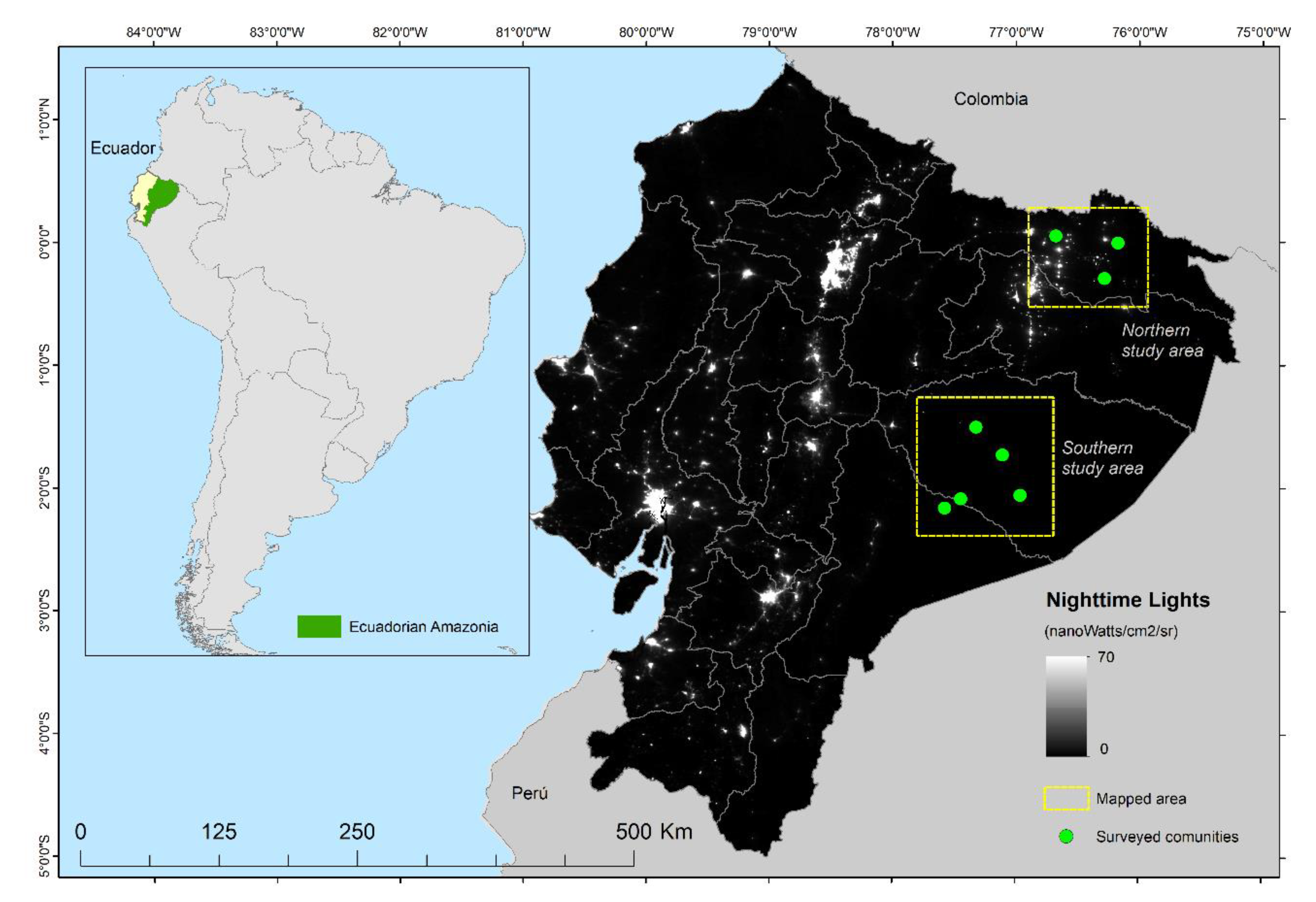
2.1. Study Area
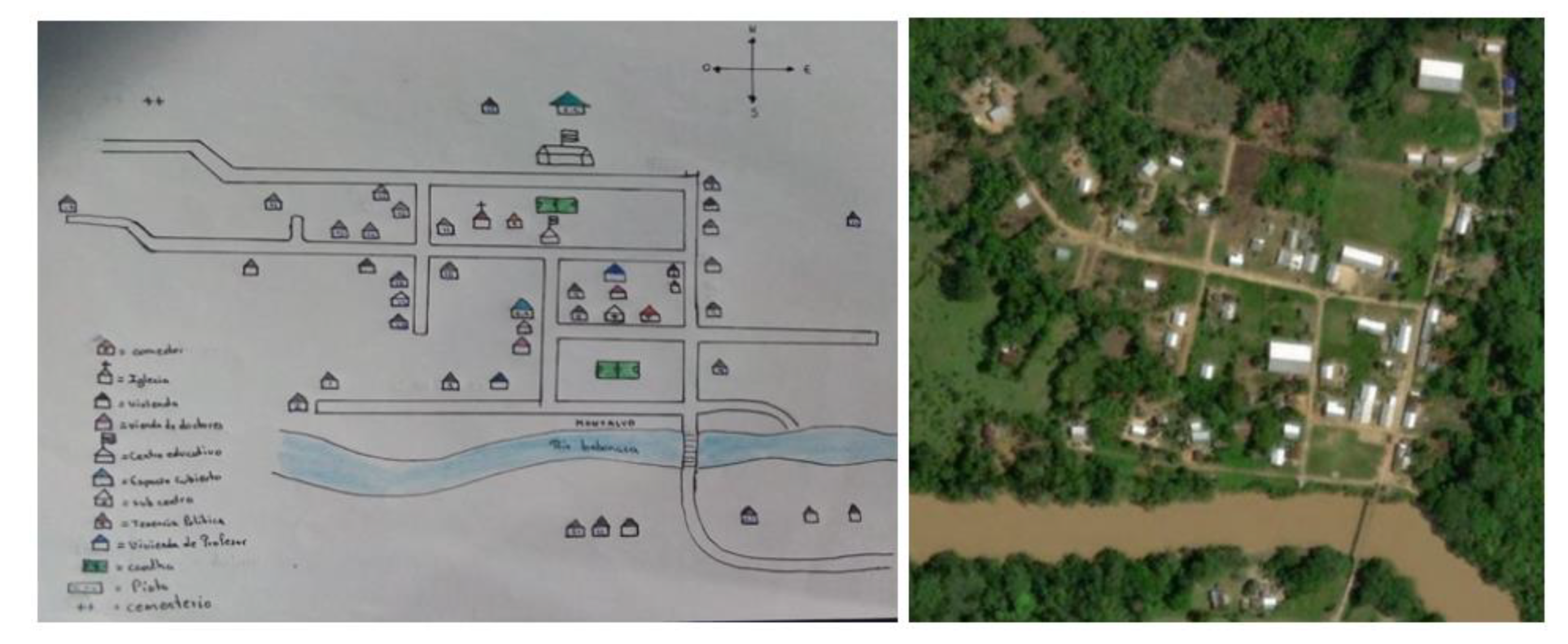
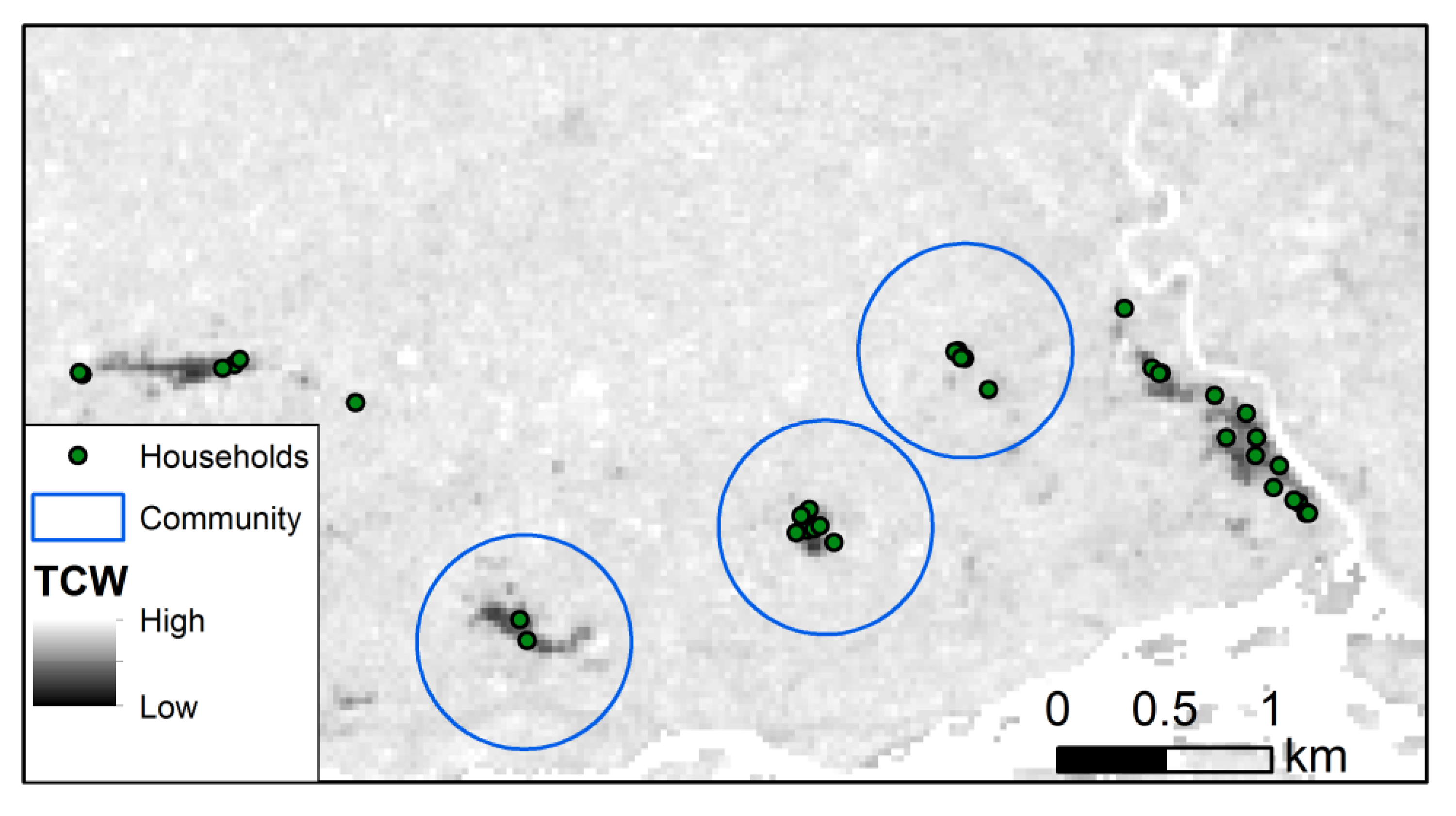
2.2. Field Data
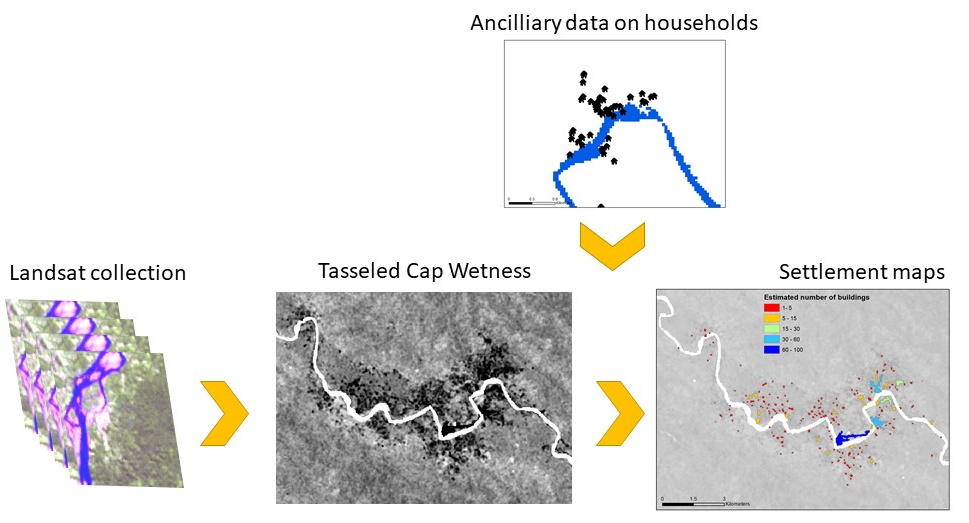
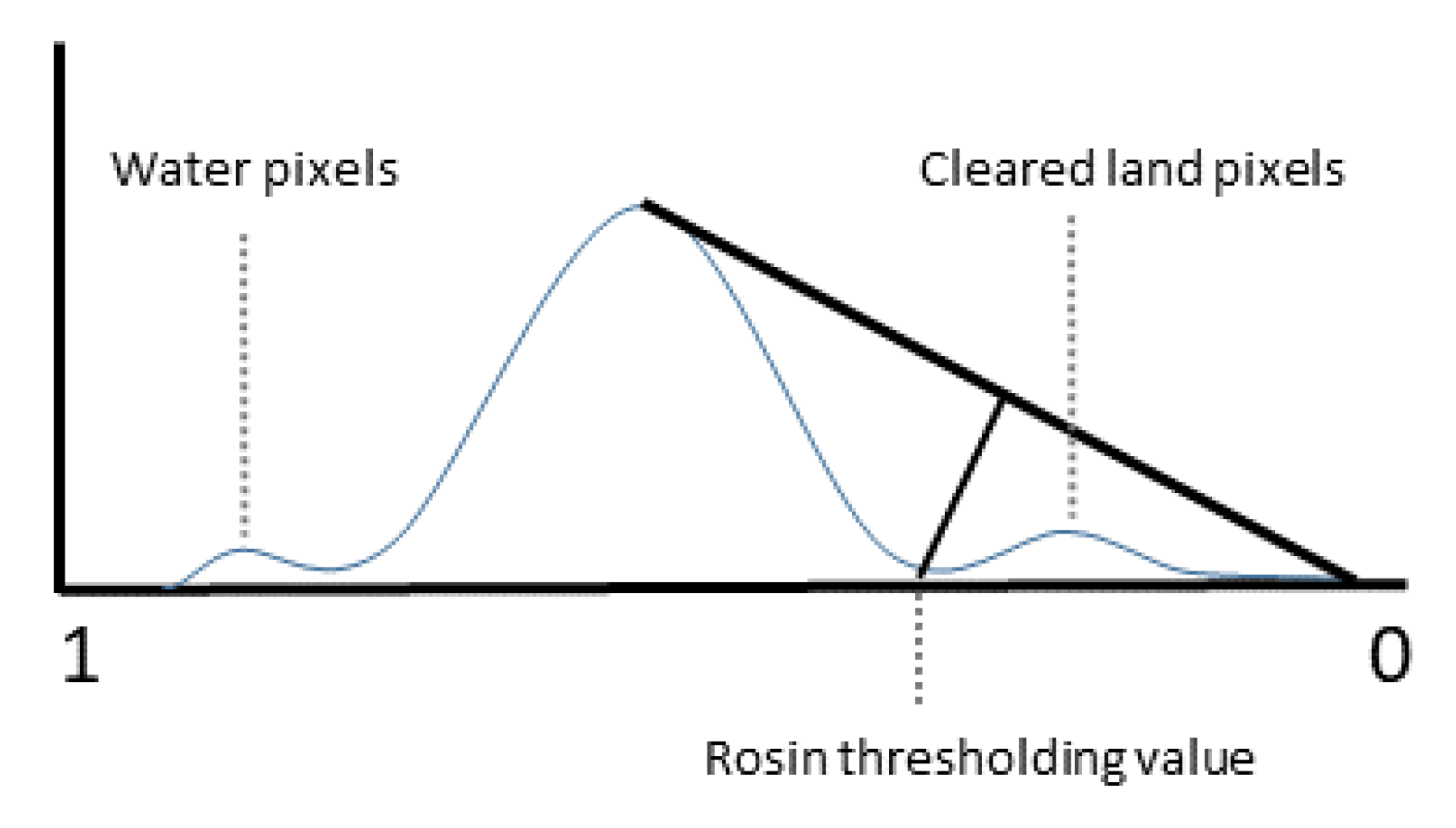
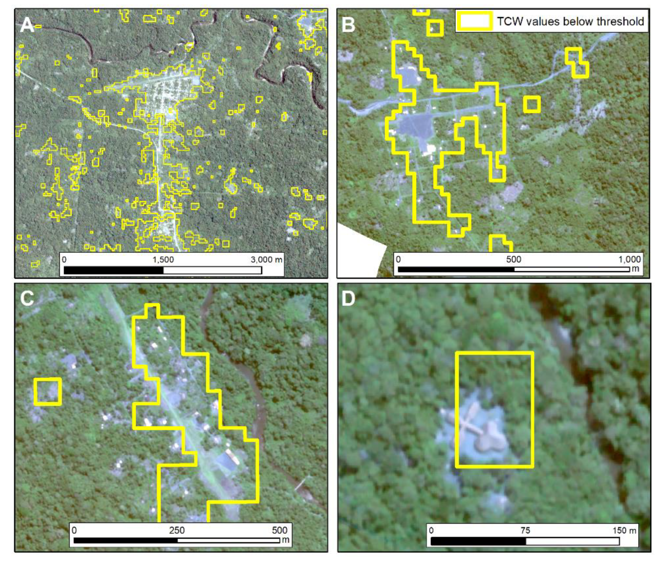
2.3. Image Processing
2.4. Settlement Modelling
2.5. Validation
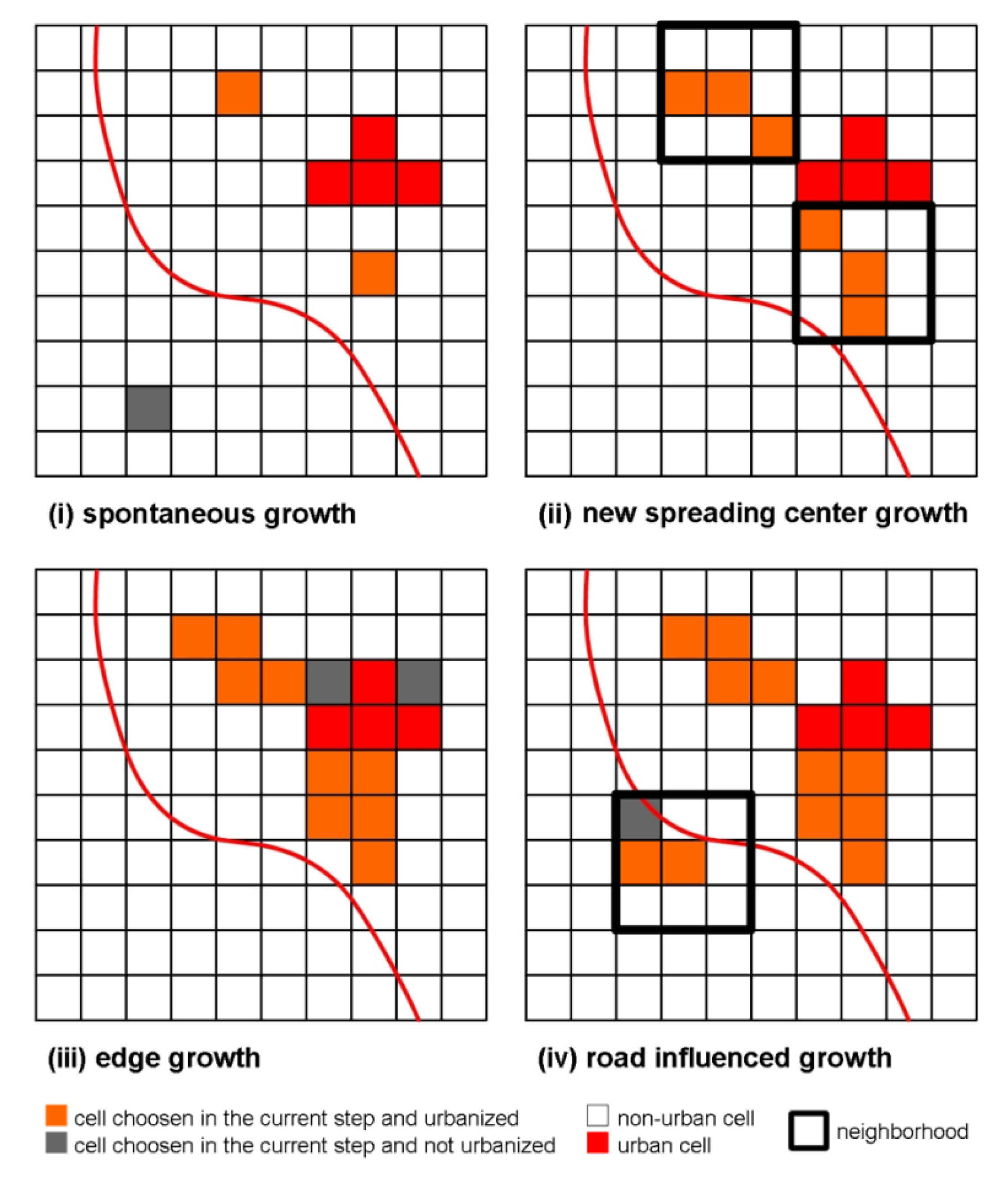
2.6. Settlement Growth Model: SLEUTH
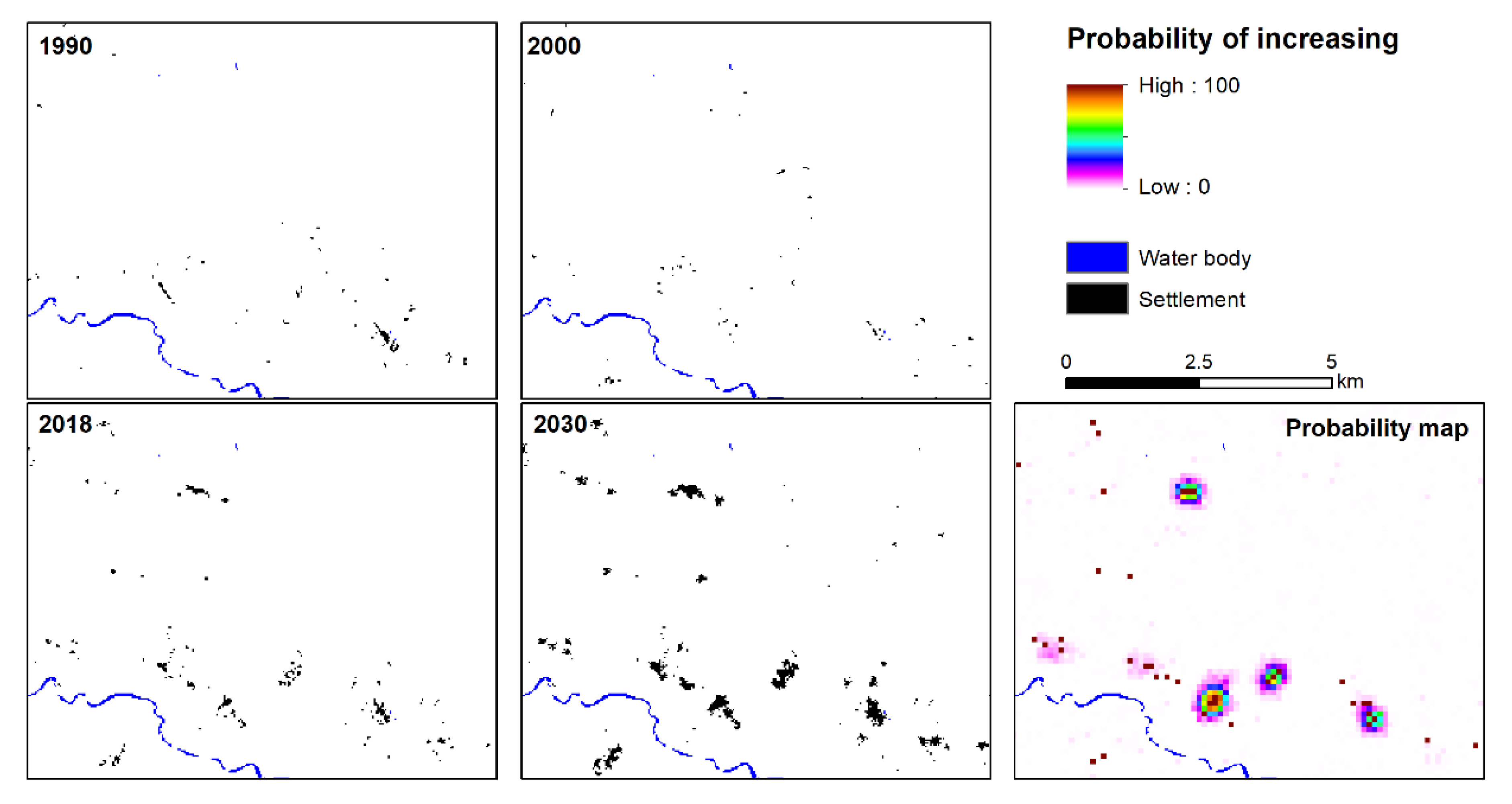
3. Results
3.1. Settlement Modelling
3.2. Validation
3.3. Settlement Projection Model: SLEUTH
4. Discussion
4.1. Settlement Modelling
4.2. Validation
4.3. Settlement Growth Model: SLEUTH
4.4. Implementation and Limitations
5. Conclusions
Author Contributions
Funding
Acknowledgments
Conflicts of Interest
References
- Andrade, C.S.; Rosa, L.P.; da Silva, N.F. Generation of electric energy in isolated rural communities in the Amazon Region a proposal for the autonomy and sustainability of the local populations. Renew. Sustain. Energy Rev. 2011, 15, 493–503. [Google Scholar] [CrossRef]
- van Els, R.H.; de Souza Vianna, J.N.; Brasil, A.C.P. The Brazilian experience of rural electrification in the Amazon with decentralized generation—The need to change the paradigm from electrification to development. Renew. Sustain. Energy Rev. 2012, 16, 1450–1461. [Google Scholar] [CrossRef]
- Valer, L.R.; Mocelin, A.; Zilles, R.; Moura, E.; Nascimento, A.C.S. Assessment of socioeconomic impacts of access to electricity in Brazilian Amazon: Case study in two communities in Mamirauá Reserve. Energy Sustain. Dev. 2014, 20, 58–65. [Google Scholar] [CrossRef]
- Bozigar, M.; Gray, C.L.; Bilsborrow, R.E. Oil Extraction and Indigenous Livelihoods in the Northern Ecuadorian Amazon. World Dev. 2016, 78, 125–135. [Google Scholar] [CrossRef] [PubMed] [Green Version]
- Lu, F.; Gray, C.; Bilsborrow, R.E.; Mena, C.F.; Erlien, C.M.; Bremner, J.; Barbieri, A.; Walsh, S.J. Contrasting Colonist and Indigenous Impacts on Amazonian Forests: Colonist versus Indigenous Deforestation. Conserv. Biol. 2010, 24, 881–885. [Google Scholar] [CrossRef] [Green Version]
- Bhattacharyya, S.C. Energy access programmes and sustainable development: A critical review and analysis. Energy Sustain. Dev. 2012, 16, 260–271. [Google Scholar] [CrossRef]
- Zhang, H.; Wu, K.; Qiu, Y.; Chan, G.; Wang, S.; Zhou, D.; Ren, X. Solar photovoltaic interventions have reduced rural poverty in China. Nat. Commun. 2020, 11, 1969. [Google Scholar] [CrossRef] [Green Version]
- Gómez, M.F.; Silveira, S. Rural electrification of the Brazilian Amazon—Achievements and lessons. Energy Policy 2010, 38, 6251–6260. [Google Scholar] [CrossRef]
- Jara, J. GIS-Based Sustainability Assessment of Decentralized Rural Electrification in the Amazon Region; University of Bonn: Bonn, Germany, 2017. [Google Scholar]
- INEC Ecuador en Cifras 2020. Available online: https://www.ecuadorencifras.gob.ec/objetivos-de-desarrollo-sostenible (accessed on 5 August 2020).
- Slough, T.; Urpelainen, J.; Yang, J. Light for all? Evaluating Brazil’s rural electrification progress, 2000–2010. Energy Policy 2015, 86, 315–327. [Google Scholar] [CrossRef]
- Sovacool, B.K.; D’Agostino, A.L.; Jain Bambawale, M. The socio-technical barriers to Solar Home Systems (SHS) in Papua New Guinea: “Choosing pigs, prostitutes, and poker chips over panels”. Energy Policy 2011, 39, 1532–1542. [Google Scholar] [CrossRef]
- López-González, A.; Ferrer-Martí, L.; Domenech, B. Sustainable rural electrification planning in developing countries: A proposal for electrification of isolated communities of Venezuela. Energy Policy 2019, 129, 327–338. [Google Scholar] [CrossRef]
- Espinoza, J.L.; Jara-Alvear, J.; Urdiales Flores, L. Sustainability of Renewable Energy Projects in the Amazonian Region. In Sustainable Energy Mix in Fragile Environments; Tyler, M.-E., Ed.; Social and Ecological Interactions in the Galapagos Islands; Springer International Publishing: Cham, Switzerland, 2018; pp. 107–139. ISBN 978-3-319-69397-2. [Google Scholar]
- Tiba, C.; Candeias, A.L.B.; Fraidenraich, N.; Barbosa, E.D.S.; de Carvalho Neto, P.B.; de Melo Filho, J.B.A. GIS-based decision support tool for renewable energy management and planning in semi-arid rural environments of northeast of Brazil. Renew. Energy 2010, 35, 2921–2932. [Google Scholar] [CrossRef]
- Dugoua, E.; Kennedy, R.; Urpelainen, J. Satellite data for the social sciences: Measuring rural electrification with night-time lights. Int. J. Remote. Sens. 2018, 39, 2690–2701. [Google Scholar] [CrossRef]
- Mentis, D.; Howells, M.; Rogner, H.; Korkovelos, A.; Arderne, C.; Zepeda, E.; Siyal, S.; Taliotis, C.; Bazilian, M.; de Roo, A.; et al. Lighting the World: The first application of an open source, spatial electrification tool (OnSSET) on Sub-Saharan Africa. Environ. Res. Lett. 2017, 12, 085003. [Google Scholar] [CrossRef]
- Szabó, S.; Bódis, K.; Huld, T.; Moner-Girona, M. Energy solutions in rural Africa: Mapping electrification costs of distributed solar and diesel generation versus grid extension. Environ. Res. Lett. 2011, 6, 034002. [Google Scholar] [CrossRef]
- Gorelick, N.; Hancher, M.; Dixon, M.; Ilyushchenko, S.; Thau, D.; Moore, R. Google Earth Engine: Planetary-scale geospatial analysis for everyone. Remote. Sens. Environ. 2017, 202, 18–27. [Google Scholar] [CrossRef]
- Facchinelli, F.; Pappalardo, S.E.; Codato, D.; Diantini, A.; Della Fera, G.; Crescini, E.; De Marchi, M. Unburnable and Unleakable Carbon in Western Amazon: Using VIIRS Nightfire Data to Map Gas Flaring and Policy Compliance in the Yasuní Biosphere Reserve. Sustainability 2019, 12, 58. [Google Scholar] [CrossRef] [Green Version]
- Eitzinger, A.; Cock, J.; Atzmanstorfer, K.; Binder, C.R.; Läderach, P.; Bonilla-Findji, O.; Bartling, M.; Mwongera, C.; Zurita, L.; Jarvis, A. GeoFarmer: A monitoring and feedback system for agricultural development projects. Comput. Electron. Agric. 2019, 158, 109–121. [Google Scholar] [CrossRef]
- Walker, R.S.; Hamilton, M.J.; Groth, A.A. Remote sensing and conservation of isolated indigenous villages in Amazonia. R. Soc. Open Sci. 2014, 1, 140246. [Google Scholar] [CrossRef] [Green Version]
- Zhu, Z.; Wang, S.; Woodcock, C.E. Improvement and expansion of the Fmask algorithm: Cloud, cloud shadow, and snow detection for Landsats 4–7, 8, and Sentinel 2 images. Remote. Sens. Environ. 2015, 159, 269–277. [Google Scholar] [CrossRef]
- Kauth, R.J.; Thomas, G.S. The Tasselled Cap—A Graphic Description of the Spectral-Temporal Development of Agricultural Crops as Seen by Landsat. In Proceedings of the LARS Symposia, Purdue University West Lafayette Indiana, Tippercanu, IN, USA, 29 June–1 July 1976; p. 159. [Google Scholar]
- Müller, H.; Griffiths, P.; Hostert, P. Long-term deforestation dynamics in the Brazilian Amazon—Uncovering historic frontier development along the Cuiabá–Santarém highway. Int. J. Appl. Earth Obs. Geoinf. 2016, 44, 61–69. [Google Scholar] [CrossRef]
- Schultz, M.; Clevers, J.G.P.W.; Carter, S.; Verbesselt, J.; Avitabile, V.; Quang, H.V.; Herold, M. Performance of vegetation indices from Landsat time series in deforestation monitoring. Int. J. Appl. Earth Obs. Geoinf. 2016, 52, 318–327. [Google Scholar] [CrossRef]
- Zhu, Z. Change detection using landsat time series: A review of frequencies, preprocessing, algorithms, and applications. ISPRS J. Photogramm. Remote. Sens. 2017, 130, 370–384. [Google Scholar] [CrossRef]
- Pekel, J.-F.; Cottam, A.; Gorelick, N.; Belward, A.S. High-resolution mapping of global surface water and its long-term changes. Nature 2016, 540, 418–422. [Google Scholar] [CrossRef] [PubMed]
- Otsu, N. A Threshold Selection Method from Gray-Level Histograms. IEEE Trans. Syst. Man Cybern. 1979, 9, 62–66. [Google Scholar] [CrossRef] [Green Version]
- Li, W.; Du, Z.; Ling, F.; Zhou, D.; Wang, H.; Gui, Y.; Sun, B.; Zhang, X. A Comparison of Land Surface Water Mapping Using the Normalized Difference Water Index from TM, ETM+ and ALI. Remote. Sens. 2013, 5, 5530–5549. [Google Scholar] [CrossRef] [Green Version]
- Rosin, P.L. Unimodal thresholding. Pattern Recogn. 2001, 34, 2083–2096. [Google Scholar] [CrossRef]
- Clarke, K.C. Mapping and Modelling Land Use Change: An Application of the SLEUTH Model. In Landscape Analysis and Visualisation; Pettit, C., Cartwright, W., Bishop, I., Lowell, K., Pullar, D., Duncan, D., Eds.; Lecture Notes in Geoinformation and Cartography; Springer: Berlin/Heidelberg, Germany, 2008; pp. 353–366. ISBN 978-3-540-69167-9. [Google Scholar]
- Ulam, S. Random processes and transformations; American Mathematical Society: Cambridge, MA, USA, 1950. [Google Scholar]
- von Neumann, J. The general and logical theory of automata. Cereb. Mech. Behav. 1951, 1951, 1–41. [Google Scholar]
- Clarke, K.C.; Hoppen, S.; Gaydos, L. A self-modifying cellular automaton model of historical urbanization in the San Francisco Bay area. Environ. Plan. B Plan. Des. 1997, 24, 247–261. [Google Scholar] [CrossRef] [Green Version]
- Chaudhuri, G.; Clarke, K. The SLEUTH Land Use Change Model: A Review. Environ. Resour. Res. 2013, 1. [Google Scholar] [CrossRef]
- Rienow, A.; Stenger, D.; Menz, G. Sprawling cities and shrinking regions – forecasting urban growth in the Ruhr for 2025 by coupling cells and agents. Erdkunde 2014, 68, 85–107. [Google Scholar] [CrossRef]
- Badmos, O.S.; Rienow, A.; Callo-Concha, D.; Greve, K.; Jürgens, C. Simulating slum growth in Lagos: An integration of rule based and empirical based model. Comput. Environ. Urban Syst. 2019, 77, 101369. [Google Scholar] [CrossRef]
- Saxena, A.; Jat, M.K. Land suitability and urban growth modeling: Development of SLEUTH-Suitability. Comput. Environ. Urban Syst. 2020, 81, 101475. [Google Scholar] [CrossRef]
- Goetzke, R. Entwicklung Eines Fernerkundungsgestützten Modellverbundes Zur Simulation Des Urban-Ruralen Landnutzungswandels in Nordrhein-Westfalen; University of Bonn: Hamburg, Germany, 2011. [Google Scholar]
- Schmitz, M.; Bode, T.; Thamm, P.; Cremmers, A.B. XULU—A generic JAVA-based platform to simulate land use and land cover change (LUCC). In Proceedings of the MODSIM 2007 International Congress on Modelling and Simulation, Christchurch, New Zealand, 10–13 December 2007; Modelling and Simulation Society of Australia and New Zealand: Canberra, Australia; Christchurch, New Zealand, 2007; pp. 5–7. [Google Scholar]
- Pontius, R.G.; Boersma, W.; Castella, J.-C.; Clarke, K.; de Nijs, T.; Dietzel, C.; Duan, Z.; Fotsing, E.; Goldstein, N.; Kok, K.; et al. Comparing the input, output, and validation maps for several models of land change. Ann. Reg. Sci. 2008, 42, 11–37. [Google Scholar] [CrossRef] [Green Version]
- Rienow, A.; Goetzke, R. Supporting SLEUTH—Enhancing a cellular automaton with support vector machines for urban growth modeling. Comput. Environ. Urban Syst. 2015, 49, 66–81. [Google Scholar] [CrossRef]
- Baetens, L.; Desjardins, C.; Hagolle, O. Validation of Copernicus Sentinel-2 Cloud Masks Obtained from MAJA, Sen2Cor, and FMask Processors Using Reference Cloud Masks Generated with a Supervised Active Learning Procedure. Remote. Sens. 2019, 11, 433. [Google Scholar] [CrossRef] [Green Version]
- Pesaresi, M.; Huadong, G.; Blaes, X.; Ehrlich, D.; Ferri, S.; Gueguen, L.; Halkia, M.; Kauffmann, M.; Kemper, T.; Lu, L.; et al. A Global Human Settlement Layer from Optical HR/VHR RS Data: Concept and First Results. IEEE J. Sel. Top. Appl. Earth Obs. Remote. Sens. 2013, 6, 2102–2131. [Google Scholar] [CrossRef]
- Esch, T.; Heldens, W.; Hirner, A.; Keil, M.; Marconcini, M.; Roth, A.; Zeidler, J.; Dech, S.; Strano, E. Breaking new ground in mapping human settlements from space—The Global Urban Footprint. ISPRS J. Photogramm. Remote. Sens. 2017, 134, 30–42. [Google Scholar] [CrossRef] [Green Version]
- Kantakumar, L.; Sawant, N.; Kumar, S. Forecasting urban growth based on GIS, RS and SLEUTH model in Pune. Int. J. Geomat. Geosci. 2011, 2, 568–579. [Google Scholar]
- Doll, C.N.H.; Pachauri, S. Estimating rural populations without access to electricity in developing countries through night-time light satellite imagery. Energy Policy 2010, 38, 5661–5670. [Google Scholar] [CrossRef]
- Falchetta, G.; Pachauri, S.; Parkinson, S.; Byers, E. A high-resolution gridded dataset to assess electrification in sub-Saharan Africa. Sci. Data 2019, 6, 110. [Google Scholar] [CrossRef] [PubMed] [Green Version]
- Domínguez, J.; Pinedo-Pascua, I. GIS Tool for Rural Electrification with Renewable Energies in Latin America. In Proceedings of the 2009 International Conference on Advanced Geographic Information Systems & Web Services, Cancun, Mexico, 1–7 February 2009; IEEE: Cancun, Mexico, 2009; pp. 171–176. [Google Scholar]
- Htein, L.; Bobyl, A.; Malyshkin, V.; Sanin, S.; Cheremisin, A.; Gerner, A. Electrification of rural villages in Myanmar with photovoltaic solar energy on the basis of GIS data. In IOP Conference Series: Earth and Environmental Science; IOP Publishing: Bristol, UK, 2019; Volume 390, p. 012048. [Google Scholar] [CrossRef]
- Eilola, S.; Käyhkö, N.; Ferdinands, A.; Fagerholm, N. A bird’s eye view of my village—Developing participatory geospatial methodology for local level land use planning in the Southern Highlands of Tanzania. Landscape Urban Plann. 2019, 190, 103596. [Google Scholar] [CrossRef]
- Kelly, J.; Herlihy, P.; Tappan, T.; Hilburn, A.; Fahrenbruch, M. From Cognitive Maps to Transparent Static Web Maps: Tools for Indigenous Territorial Control in La Muskitia, Honduras. Cartographica: Int. J. Geographic Inf. Geovisualization 2017, 52, 1–19. [Google Scholar] [CrossRef]
- van Gevelt, T.; Canales Holzeis, C.; George, F.; Zaman, T. Indigenous community preferences for electricity services: Evidence from a choice experiment in Sarawak, Malaysia. Energy Policy 2017, 108, 102–110. [Google Scholar] [CrossRef]
- Vasconez, J. Informe General del Inventario de Instalaciones Fotovoltaicas y Otros Sistemas de Energías Renovables de Hasta 500kW; Ministry of Electricity and Renewable Energy: Quito, Ecuador, 2010. [Google Scholar]
- Ten, M.; Neira, M.; Navarro, G.; Cordero, M. Experiencias de Modelos de Gestión Offgrid, en Ecuador e Internacionalmente; FEDETA: Quito, Ecuador, 2015. (In Spanish) [Google Scholar]
- Moner-Girona, M.; Bódis, K.; Huld, T.; Kougias, I.; Szabó, S. Universal access to electricity in Burkina Faso: scaling-up renewable energy technologies. Environ. Res. Lett. 2016, 11, 084010. [Google Scholar] [CrossRef]
- MacLachlan, A.; Roberts, G.; Biggs, E.; Boruff, B. Subpixel land-cover classification for improved urban area estimates using Landsat. Int. J. Remote. Sens. 2017, 38, 5763–5792. [Google Scholar] [CrossRef]


| Input Data | Description and Source | Application |
|---|---|---|
| Settlement 1990 | TCW from Landsat-5 imagery and manual threshold. | Calibration |
| Settlement 2000 | TCW from Landsat-7 and manual threshold. | Calibration, validation |
| Settlement 2018 | TCW and Rosin threshold method for Landsat-8 imagery. | Validation, predictive simulation |
| Roads | National road dataset | Calibration, validation, predictive simulation |
| Slope | Shuttle Radar Topography Mission | Calibration, validation, predictive simulation |
| Rivers | Global Surface Water [28] | Exclusion layer |
| Satellite Data | r | R2 | Satellite and Survey Data | r | R2 | ||
|---|---|---|---|---|---|---|---|
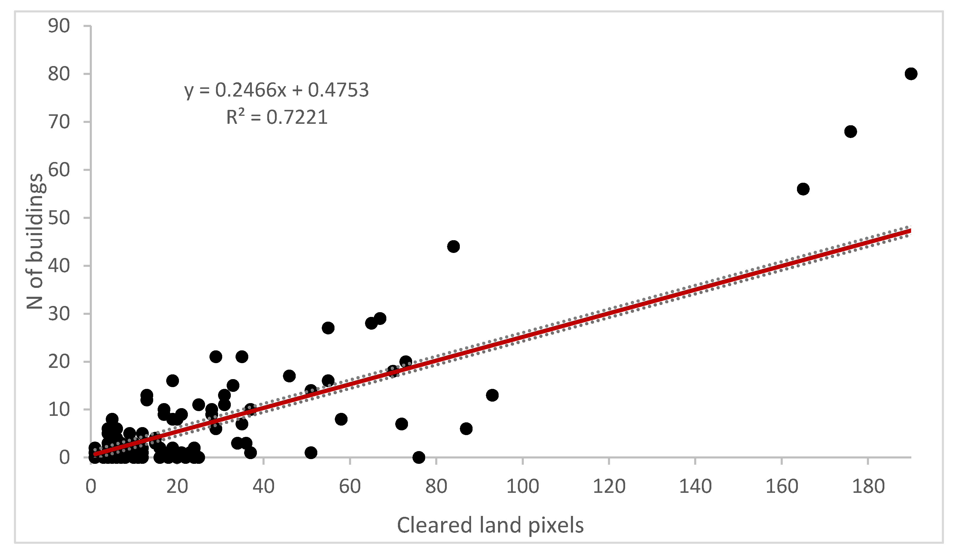
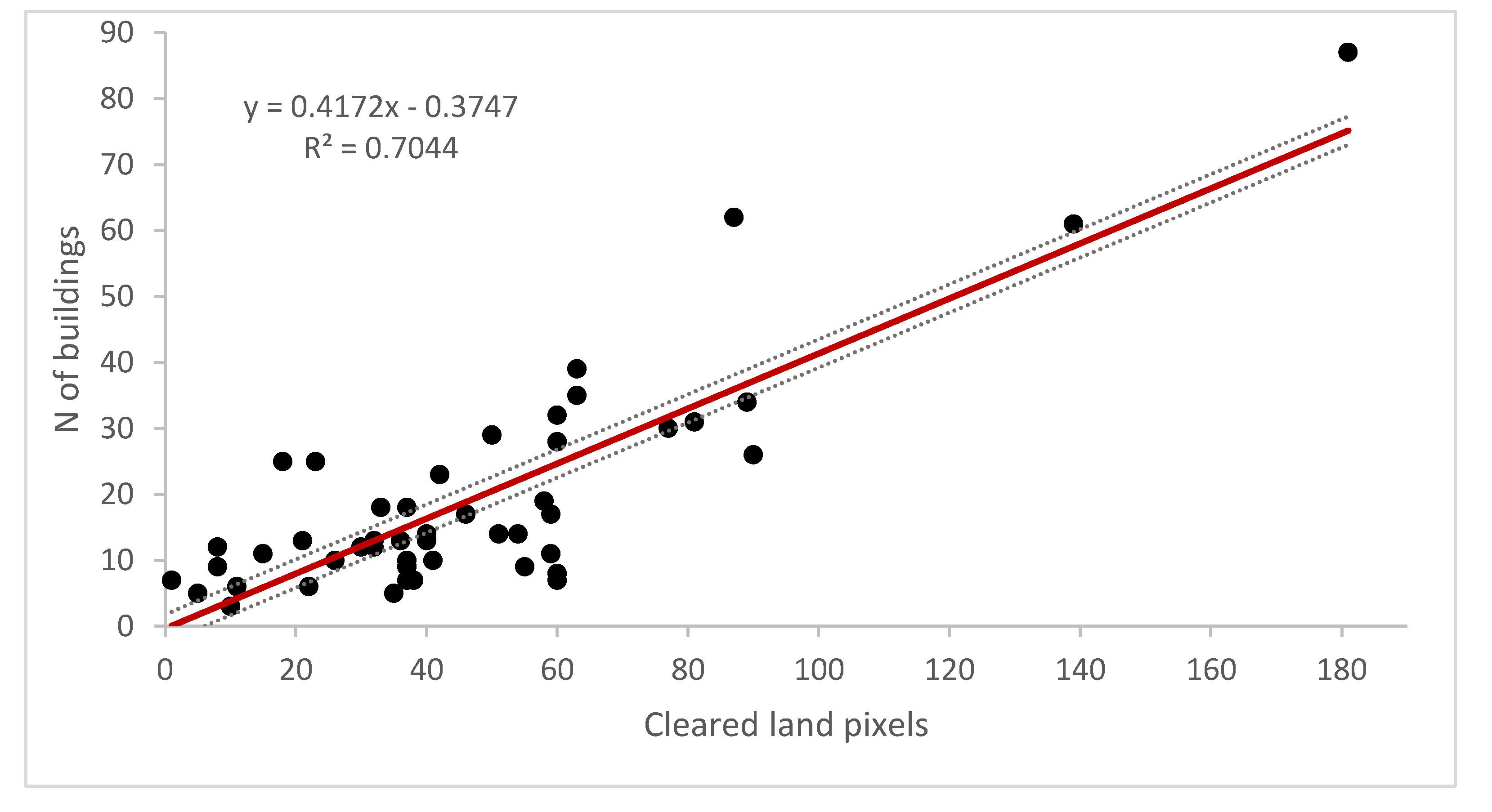
| Digitized buildings | Cleared land pixels | 0.83 | 0.70 | Digitized buildings | Houses | 0.58 | 0.32 |
| Survey data | r | R2 | Digitized buildings | Houses + infrastruct. | 0.64 | 0.40 | |
| Inhabitants | Houses | 0.82 | 0.67 | Cleared land pixels | Inhabitants | 0.30 | 0.07 |
| Inhabitants | Houses + infrastruct. | 0.82 | 0.66 | Cleared land pixels | Houses | 0.30 | 0.07 |
| Houses | Infrastruct. | 0.55 | 0.29 | Cleared land pixels | Houses + infrastruct. | 0.36 | 0.11 |
| Inhabitants | Infrastruct. | 0.46 | 0.20 | ||||
| SLEUTH Results | North | South |
|---|---|---|
| Spread coefficient | 25 | 16 |
| Dispersion coefficient | 31 | 10 |
| Breed coefficient | 11 | 14 |
| Settlements observed 1990 | 109,540 ha | 9925 ha |
| Settlements observed 2000 | 316,415 ha | 40,507 ha |
| Settlements observed 2018 | 891,761 ha | 79,373 ha |
| Settlements simulated 2018 | 890,845 ha | 84,960 ha |
| Settlements simulated 2030 | 1,504,175 ha | 125,960 ha |
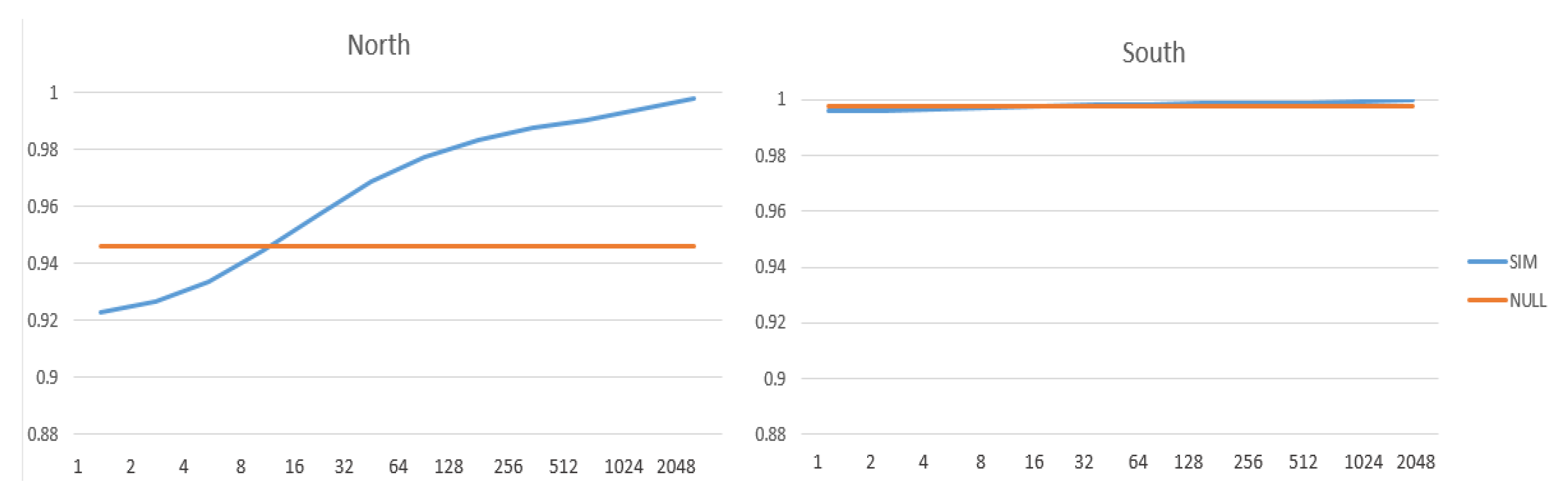
| Ft calibration 90–00 | 0.99 | 0.99 |
| Ft validation 00–18 | 0.93 | 0.99 |
| null resolution | 16 | 16 |
| sensitivity | 0.54 | 0.57 |
| false negative rate | 0.46 | 0.43 |
| specificity | 0.96 | 1.00 |
| false positive rate | 0.04 | 0.00 |
| Kappa | 0.50 | 0.55 |
| Fuzzy Kappa | 0.69 | 0.72 |
| Kappa quantity | 1.00 | 0.97 |
| Kappa location | 0.50 | 0.57 |
© 2020 by the authors. Licensee MDPI, Basel, Switzerland. This article is an open access article distributed under the terms and conditions of the Creative Commons Attribution (CC BY) license (http://creativecommons.org/licenses/by/4.0/).
Share and Cite
Muro, J.; Zurita-Arthos, L.; Jara, J.; Calderón, E.; Resl, R.; Rienow, A.; Graw, V. Earth Observation for Settlement Mapping of Amazonian Indigenous Populations to Support SDG7. Resources 2020, 9, 97. https://doi.org/10.3390/resources9080097
Muro J, Zurita-Arthos L, Jara J, Calderón E, Resl R, Rienow A, Graw V. Earth Observation for Settlement Mapping of Amazonian Indigenous Populations to Support SDG7. Resources. 2020; 9(8):97. https://doi.org/10.3390/resources9080097
Chicago/Turabian StyleMuro, Javier, Leo Zurita-Arthos, José Jara, Esteban Calderón, Richard Resl, Andreas Rienow, and Valerie Graw. 2020. "Earth Observation for Settlement Mapping of Amazonian Indigenous Populations to Support SDG7" Resources 9, no. 8: 97. https://doi.org/10.3390/resources9080097
APA StyleMuro, J., Zurita-Arthos, L., Jara, J., Calderón, E., Resl, R., Rienow, A., & Graw, V. (2020). Earth Observation for Settlement Mapping of Amazonian Indigenous Populations to Support SDG7. Resources, 9(8), 97. https://doi.org/10.3390/resources9080097