


New Model of Coastal Evolution in the Ria de Vigo (NW Spain) from MIS2 to Present Day Based on the Aeolian Sedimentary Record


Abstract
:1. Introduction

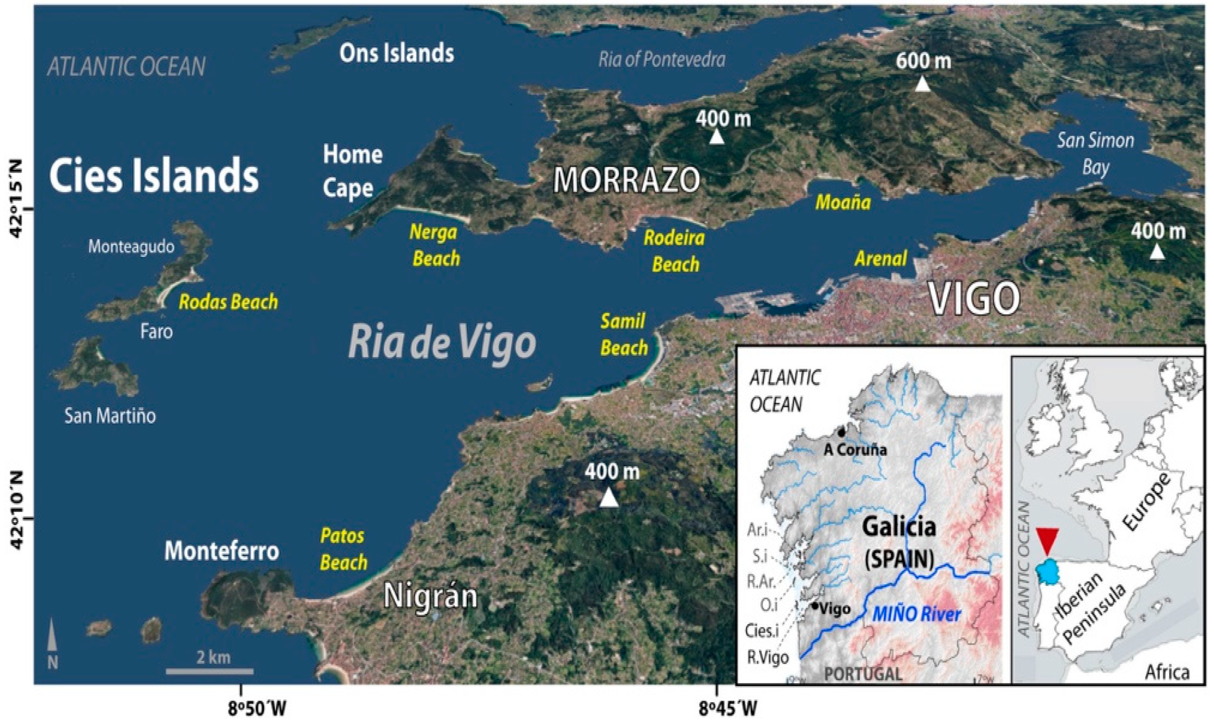
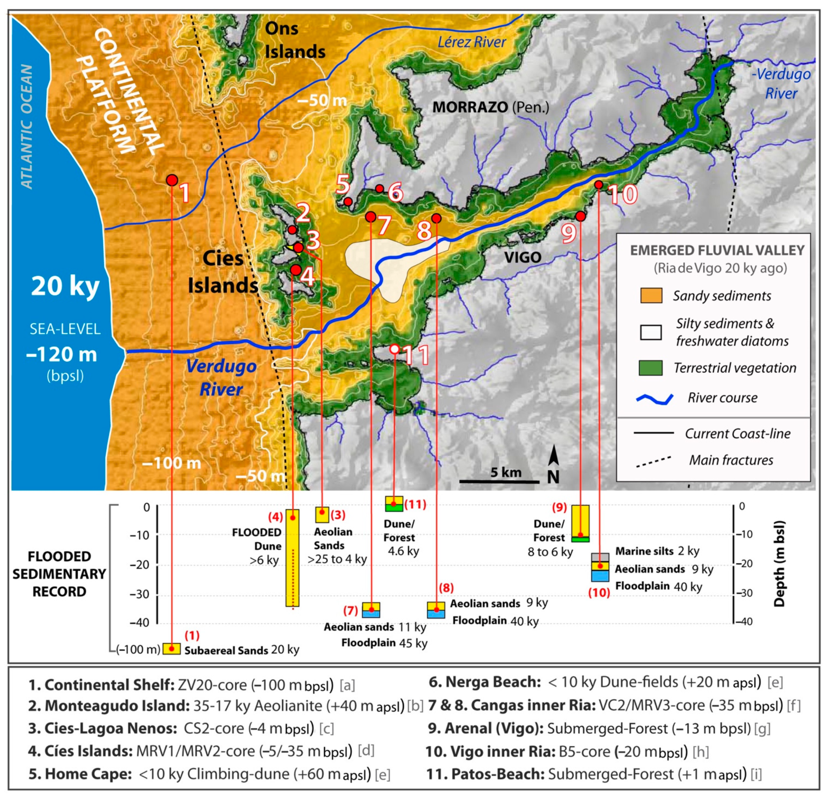
2. Study Area
3. Materials and Methods
4. Results
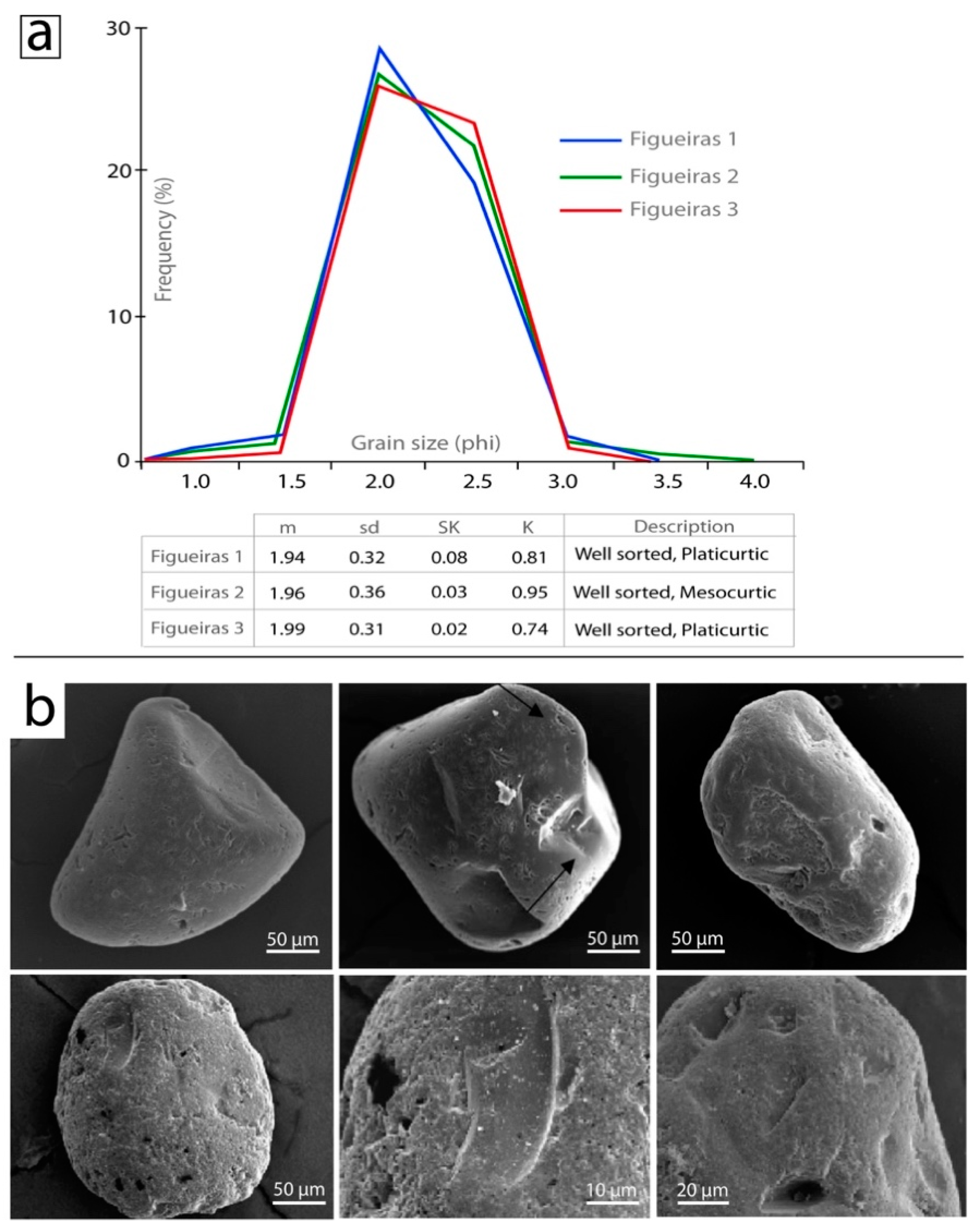
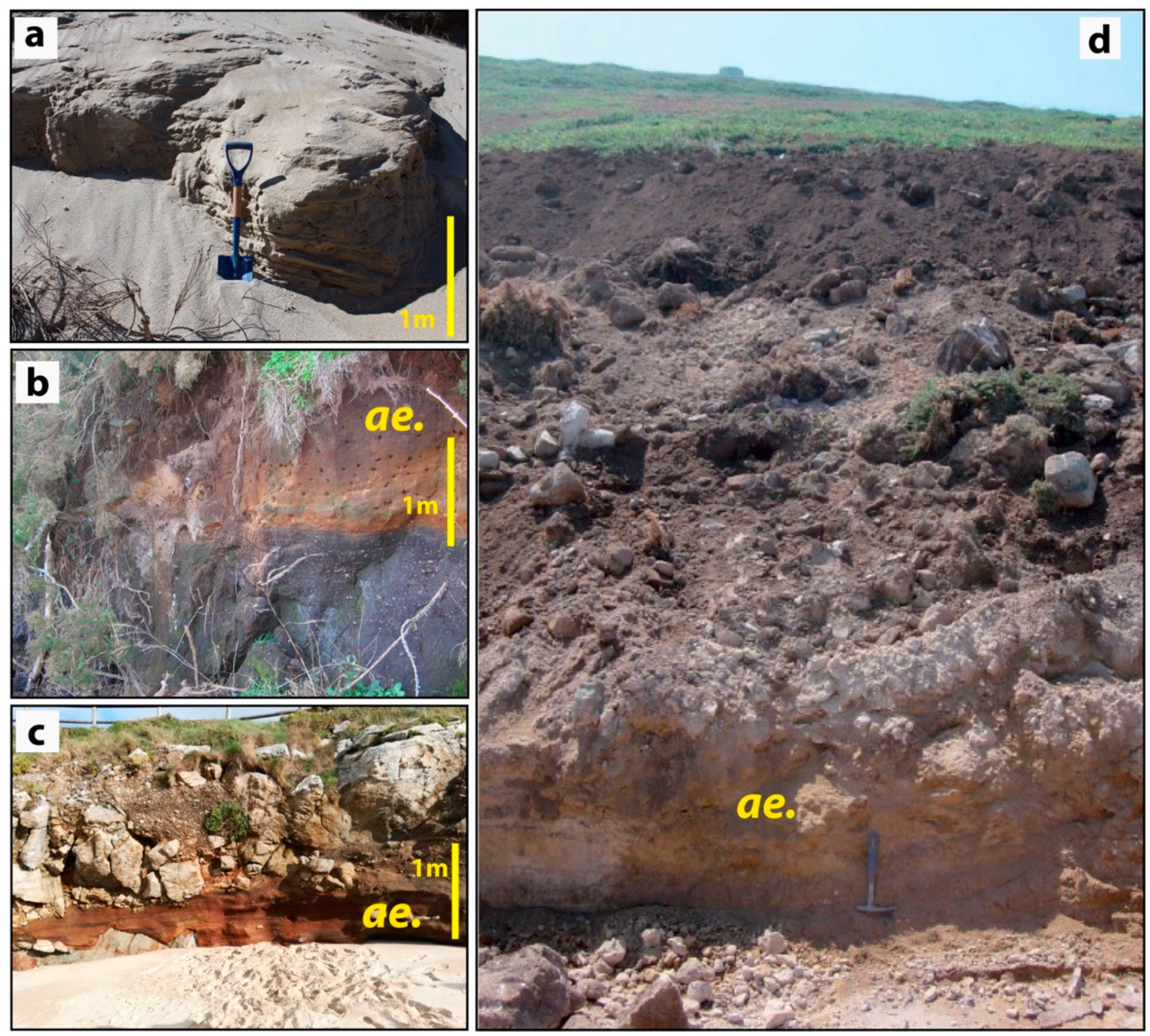
4.1. Grain Size, Morphology and Microscopic Analyses
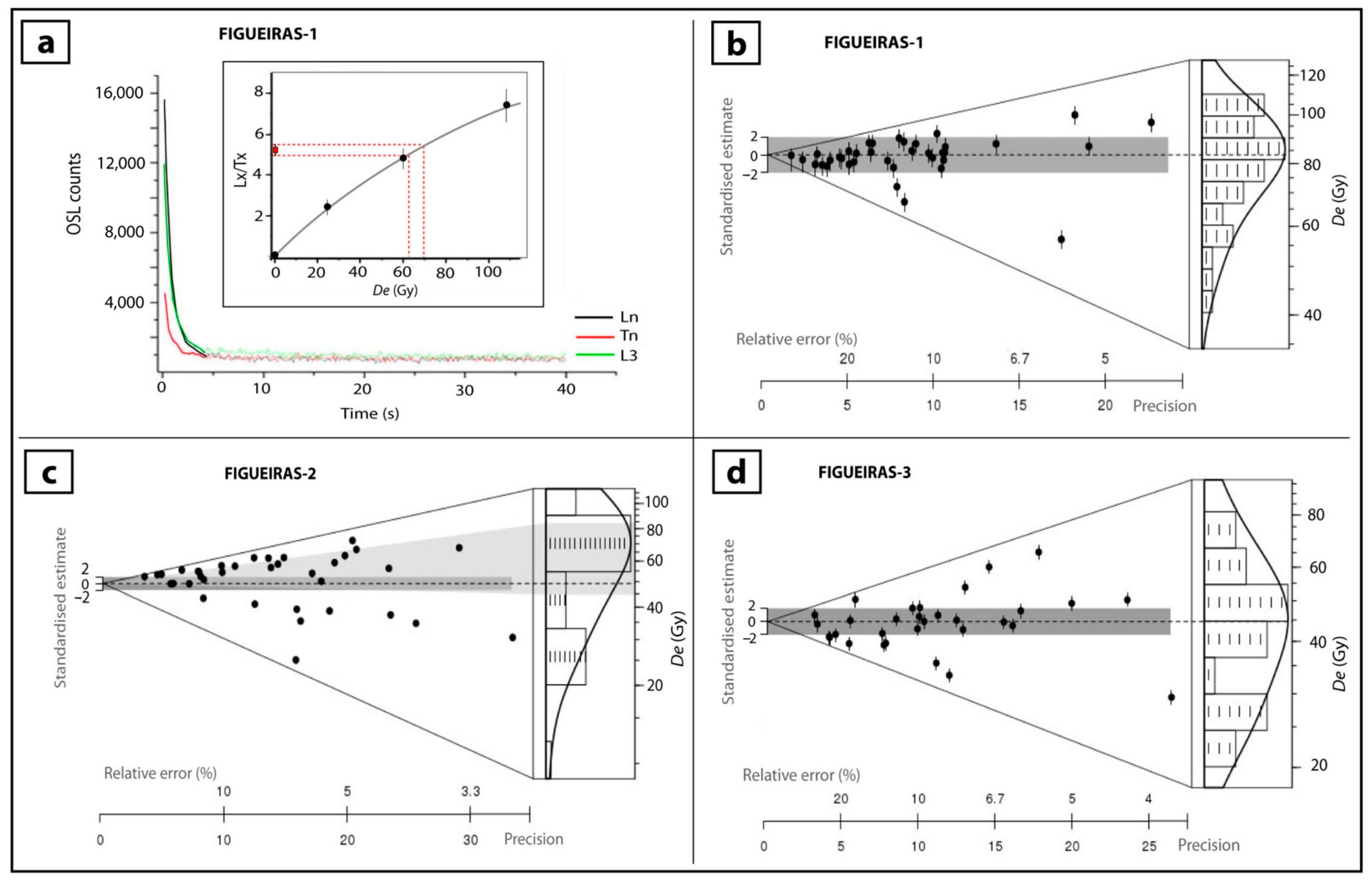
4.2. OSL-Dating: Sampling, Equivalent Dose (De) and Dose Rate (Dr)
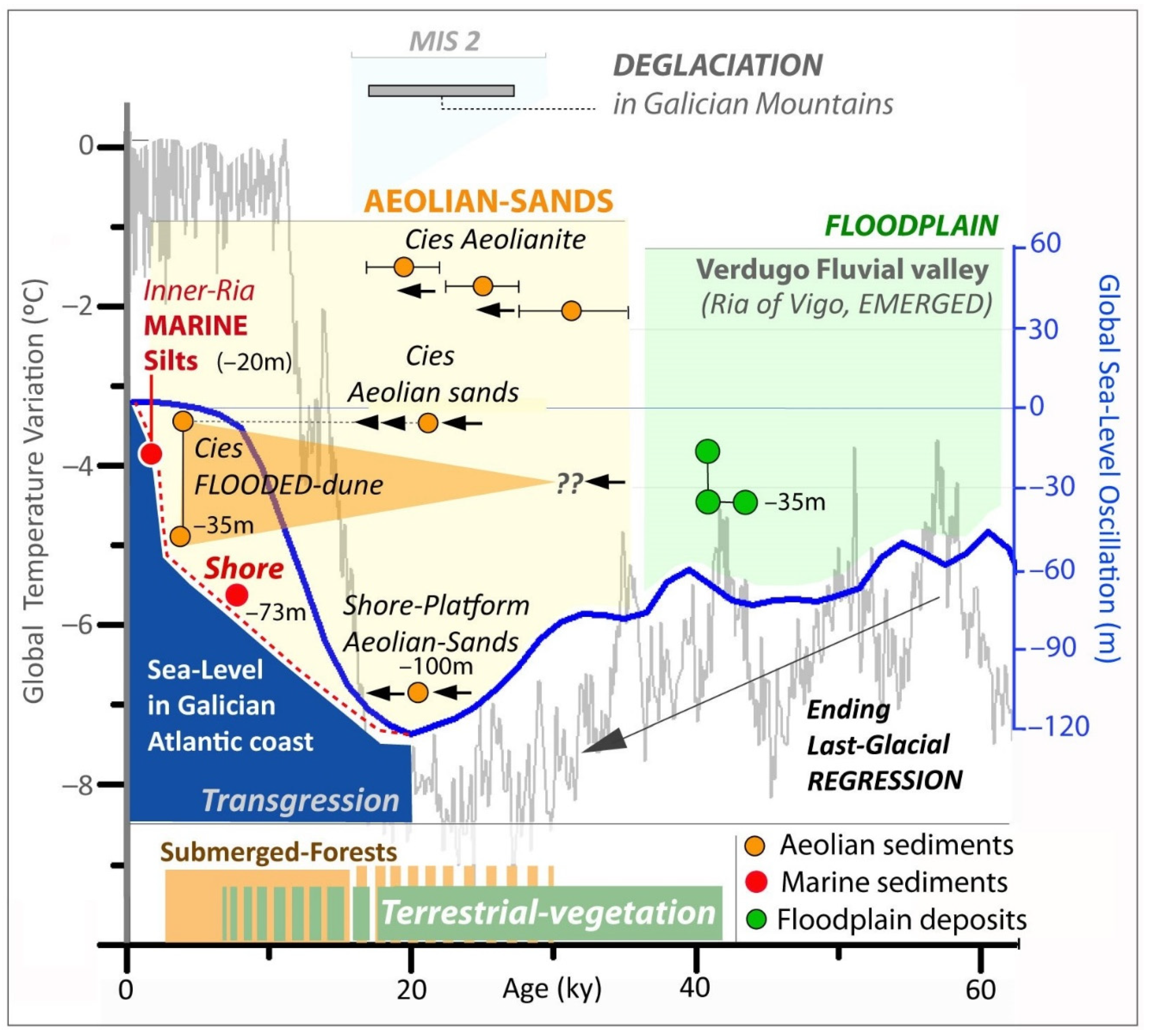
5. Discussion
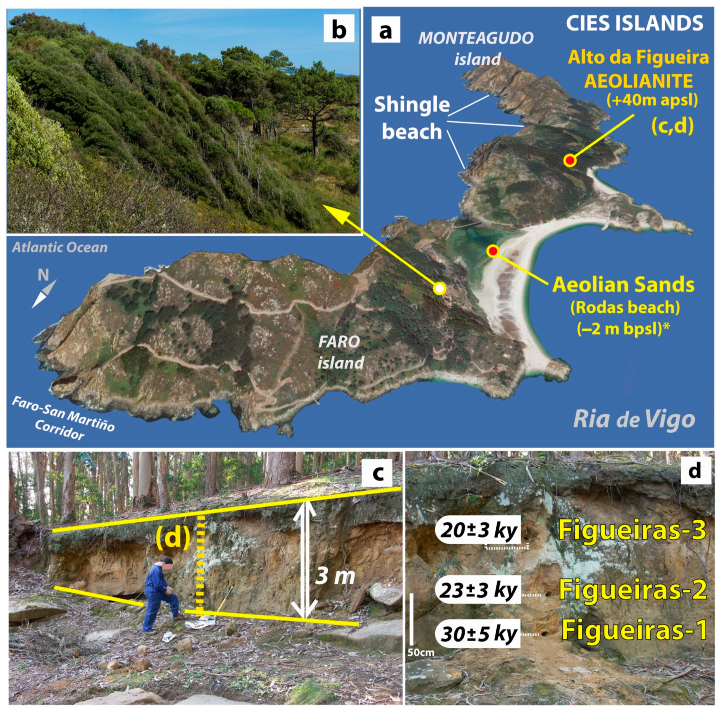
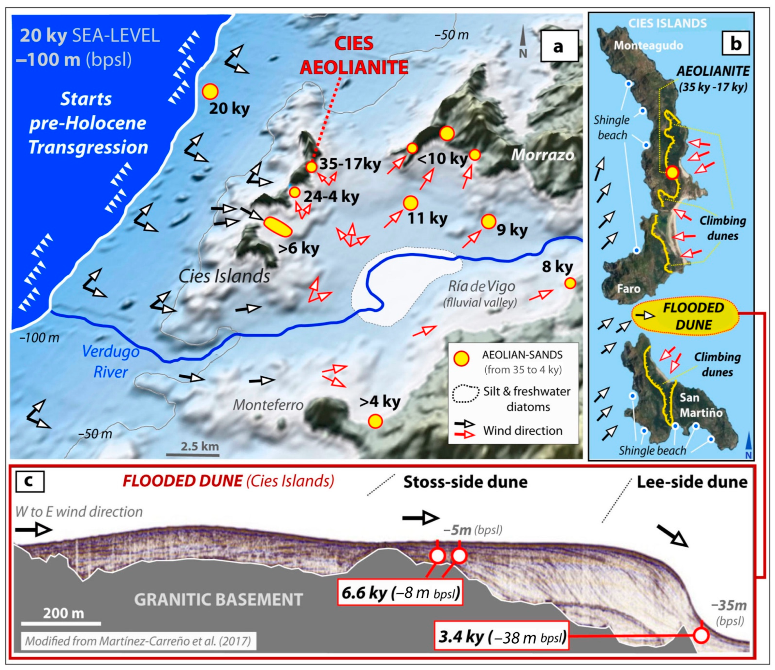
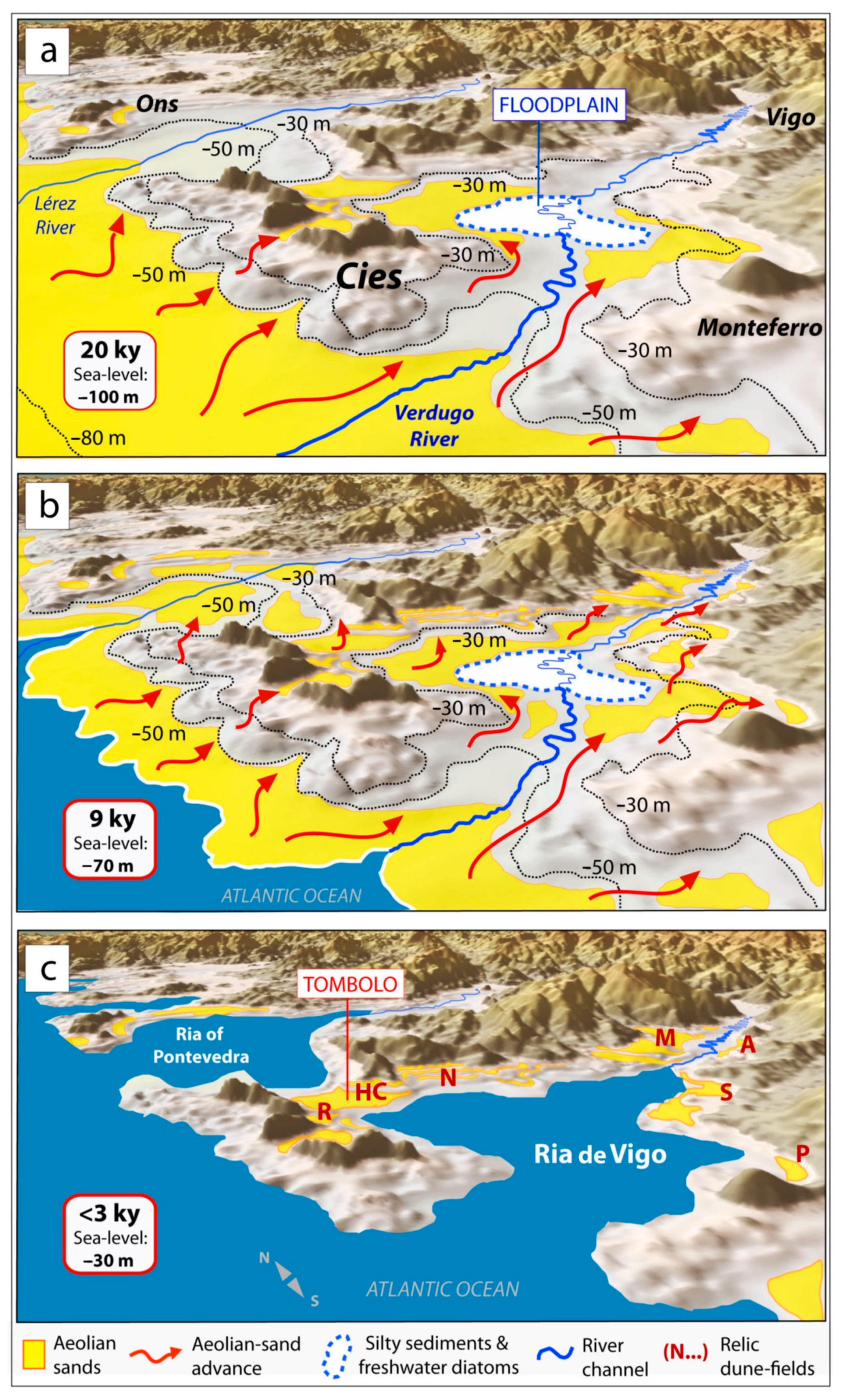
5.1. Aeolian Sediments in the Cies Islands and Ria de Vigo
5.1.1. Aeolianite Outcrop in the Eastern Side of the Cies Islands at MIS2
5.1.2. Flooded Dunes in the Cies Islands and Sea-Level
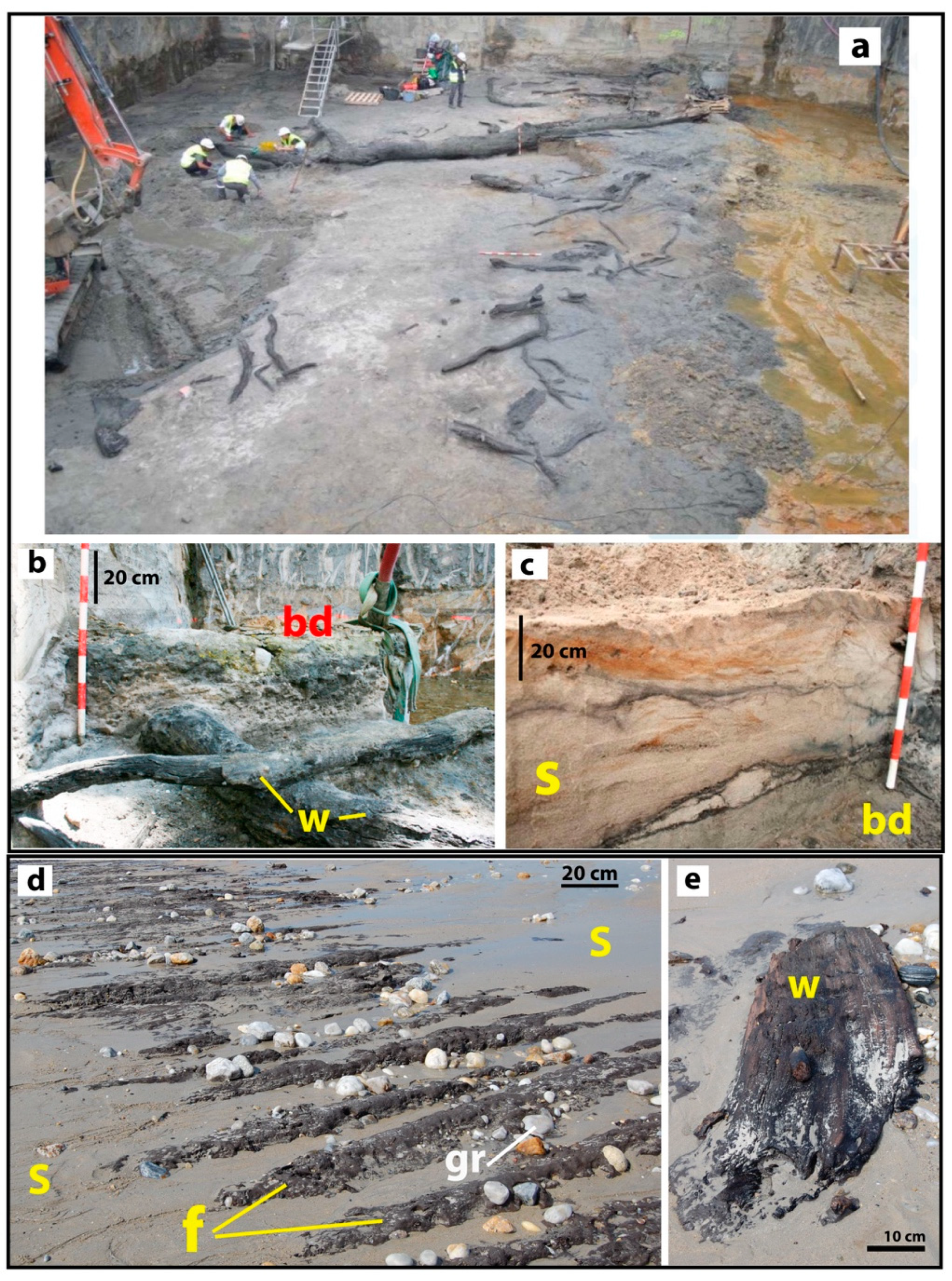
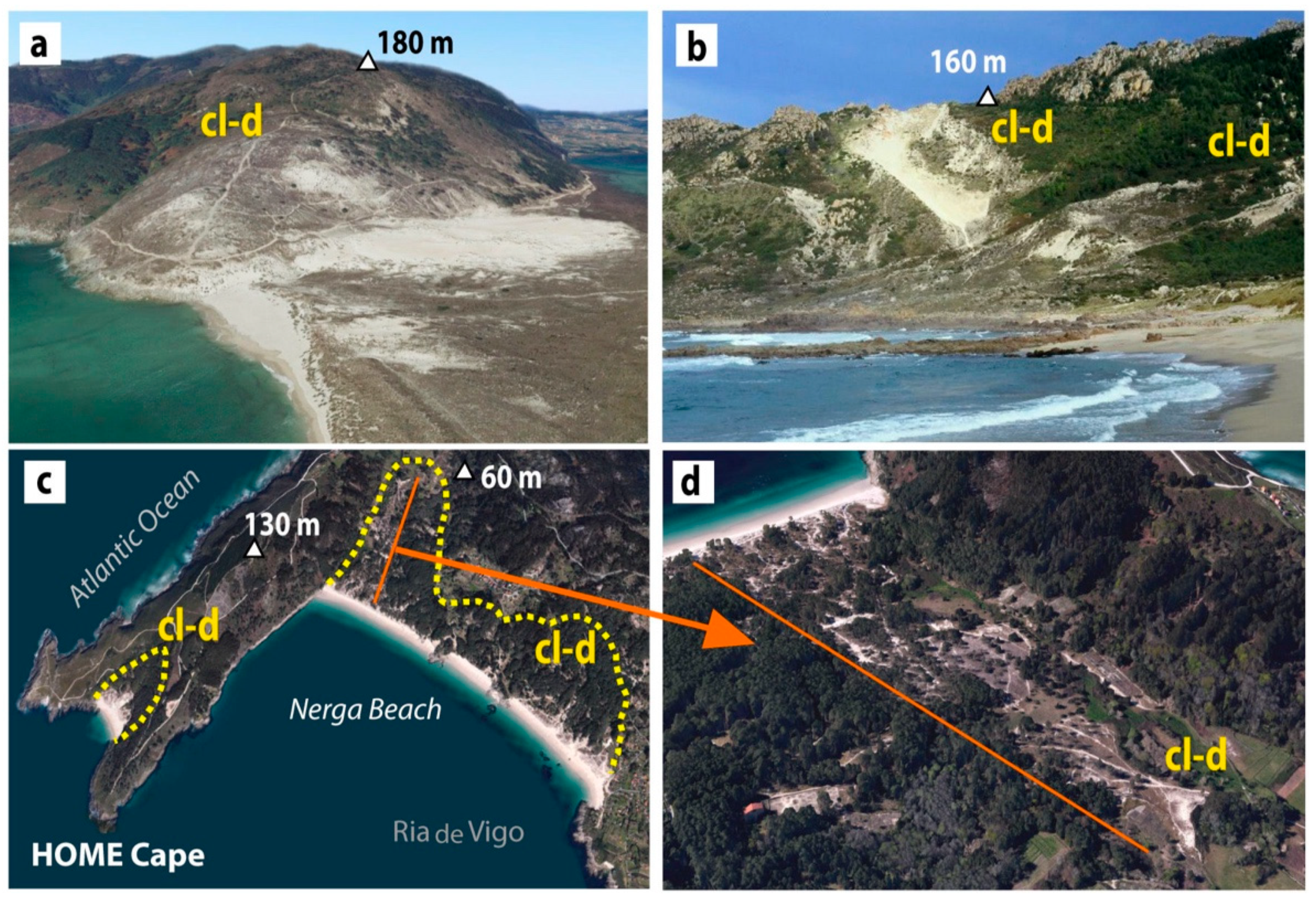
5.1.3. Dunes Filling the River Valley and Environmental Collapse
5.2. Present-Day Sea-Level and Lack of Aeolian Supply
6. Conclusions
Author Contributions
Funding
Institutional Review Board Statement
Informed Consent Statement
Data Availability Statement
Acknowledgments
Conflicts of Interest
References
- Viveen, W.; Braucher, R.; Bourlès, D.; Schoorl, J.M.; Veldkamp, A.; van Balen, R.T.; Wallinga, J.; Fernandez-Mosquera, D.; Vidal-Romani, J.R.; Sanjurjo-Sanchez, J. A 0.65 Ma chronology and incision rate assessment of the NW Iberian Miño River terraces based on 10Be and luminescence dating. Glob. Planet. Chang. 2012, 94–95, 82–100. [Google Scholar] [CrossRef]
- Ottman, F.C. Introducción a la Geología Marina y Litoral; Editorial EUDEBA: Buenos Aires, Argentina, 1967; 287p. [Google Scholar]
- Trindade, M.J.; Prudêncio, M.I.; Sanjurjo-Sánchez, J.; Vidal-Romaní, J.R.; Ferraz, T.; Fernández-Mosquera, D.; Dias, M.I. Post-depositional processes of elemental enrichment inside dark nodular masses of an ancient aeolian dune from A Coruña, Northwest Spain. Geol. Acta 2013, 11, 231–244. [Google Scholar] [CrossRef]
- Vidal-Romaní, J.R.; Grandal-d´Anglade, A. Nota sobre la última transgresión marina en la costa de Galicia. Cad. Lab. Xeol. Laxe 2018, 40, 229–246. [Google Scholar] [CrossRef]
- Gutiérrez-Becker, L. Caracterización de los Sistemas Dunares Costeros del NW Ibérico y su Evolución Durante el Cuaternario. Ph.D. Thesis, Universidad de Coruña, A Coruña, Spain, 2008. Available online: https://dialnet.unirioja.es/servlet/tesis?codigo=45245 (accessed on 7 August 2022).
- Nonn, H. Les Régiones Cotières de la Galice (Espagne). Etude Géomorpholigique; Tomo III; Publications de la Faculté des Lettres de L´Université de Strasbourg, Foundation Baulig: Paris, France, 1966; 592p. [Google Scholar]
- Rey-Salgado, J. Relación Morfosedimentaria entre la Plataforma Continental de Galicia y las Rías Bajas y su Evolución durante el Cuaternario; Instituto Español de Oceanografía: Madrid, Spain, 1993; 233p. [Google Scholar]
- Costas, S.; Muñoz-Sobrino, C.; Alejo, I.; Pérez-Arlucea, M. Holocene evolution of a rock-bounded barrier-lagoon system, Cies Islands, northwest Iberia. Earth Surf. Proc. Land. 2009, 34, 1575–1586. [Google Scholar] [CrossRef]
- Martínez-Carreño, M.; García-Gil, S. The Holocene gas system of the Ría de Vigo (NW Spain): Factors controlling the location of gas accumulations, seeps and pockmarks. Mar. Geol. 2013, 344, 82–100. [Google Scholar] [CrossRef]
- Martínez-Carreño, M.; García-Gil, S. Reinterpretation of the Quaternary sedimentary infill of the Ría de Vigo, NW Iberian Peninsula, as a compound incised valley. Quat. Sci. Rev. 2017, 173, 124–144. [Google Scholar] [CrossRef]
- Cartelle, V.; García-Moreiras, I.; Martínez-Carreño, N.; Muñoz Sobrino, C.; García-Gil, S. The role of antecedent morphology and changing sediment sources in the postglacial palaeogeographical evolution of an incised valley: The sedimentary record of the Ría de Arousa (NW Iberia). Glob. Planet. Chang. 2022, 208, 103727. [Google Scholar] [CrossRef]
- Mohamed, K.J.; Rey, D.; Rubio, B.; Rubio, B.; Vilas, F.; Frederichs, T. Interplay between detrital and diagenetic processes since the last glacial maximum on the northwest Iberian continental shelf. Quat. Res. 2010, 73, 507–520. [Google Scholar] [CrossRef]
- García-Gil, S. A natural laboratory for shallow gas: The Rías Baixas (NW Spain). Geo-Mar. Lett. 2003, 23, 215–229. [Google Scholar] [CrossRef]
- Cartelle, V. Stratigraphy, Depositional Environments, Shallow Gas and Seismic-Sequential Analysis of the Sedimentary Record of the Rias of Arousa and Ferrol. Ph.D. Thesis, Universidade de Vigo, Vigo, Spain, 2018; 351p. [Google Scholar]
- Arce-Chamorro, C.; Vidal-Romaní, J.R.; Sanjurjo-Sánchez, J. Islas Cíes: Una trampa eólica en la Ría de Vigo (NO de la Península Ibérica) al final del último glacial. Estudio del afloramiento de eolianitas de la Isla de Monteagudo (Cíes, Pontevedra, Galicia). Geogaceta 2021, 69, 3–6. Available online: https://sge.usal.es/archivos/geogacetas/geo70/Geo70_p_03_06.pdf (accessed on 7 July 2022).
- Arce-Chamorro, C. Datación por Luminiscencia de Depósitos Fluviales y Eólicos en el Margen Occidental de Galicia. Ph.D. Thesis, Universidade da Coruña, A Coruña, Spain, 2017. Available online: http://hdl.handle.net/2183/19810 (accessed on 7 August 2022).
- Arce-Chamorro, C.; Vidal-Romaní, J.R. Late-Pleistocene chronology of coastal fluvial deposits at the mouth of the Ulla River in the Ría de Arousa (Galicia, NW Spain) by OSL dating. Cad. Lab. Xeol. Laxe 2021, 43, 61–88. [Google Scholar] [CrossRef]
- Ribeiro, H.; Pinto de Jesus, A.; Mosquera, D.F.; Abreu, I.; Vidal-Romaní, J.R.; Noronha, F. Estudo de un Terraço de Lavadores. Contribuiçao Para a Deduçao das Condiçoes Paleoclimáticas No Plistocénico Médio. E-Terra: Revista Electrónica de Ciências da Terra. VIII Congreso Nacional de Geologia, Sociedade Geológica de Portugal, Portugal. 2010. Available online: https://repositorio-aberto.up.pt/bitstream/10216/53062/2/48388.pdf (accessed on 7 August 2022).
- Ribeiro, H.; Pinto de Jesus, A.; Sanjurjo-Sánchez, J.; Abreu, I.; Romani, J.R.V.; Noronha, F. Multidisciplinary study of the quaternary deposits of the Vila Nova de Gaia, NW Portugal, and its climate significance. J. Iber. Geol. 2019, 45, 553–563. [Google Scholar] [CrossRef]
- Hesp, P.A.; DaSilva, M.; Miot da Silva, G.; Bruce, D.; Keane, R. Review and direct evidence of transgressive aeolian sand sheet and dunefield initiation. Earth Surf. Process. Landf. 2022, 47, 2660–2675. [Google Scholar] [CrossRef]
- Arce-Chamorro, C.; Vidal-Romaní, J.R.; Sanjurjo-Sánchez, J. Chronology of four climbing-dunes outcrops on the Atlantic coast of Galicia (NW Spain) linked to the sea-level fall during the MIS6 and MIS4 isotopic stages. J. Mar. Sci. Eng. 2022, 10, 312. [Google Scholar] [CrossRef]
- Costas, S.; Jerez, S.; Trigo, R.M.; Bogle, R.; Rebêlo, L. Sand invasion along the Portuguese coast forced by westerly shifts during cold climate events. Quat. Sci. Rev. 2012, 42, 15–28. [Google Scholar] [CrossRef]
- Fick, S.E.; Hijmans, R.J. WorldClim 2: New 1-km spatial resolution climate surfaces for global land areas. Int. J. Climatol. 2017, 37, 4302–4315. [Google Scholar] [CrossRef]
- Jackson, D.W.T.; Costas, S.; González-Villanueva, R.; Cooper, A. A global ‘greening’ of coastal dunes: An integrated consequence of climate change? Glob. Planet. Chang. 2019, 182, 103026. [Google Scholar] [CrossRef]
- Flor-Blanco, G.; Alcántara-Carrió, J.; Jackson, D.W.T.; Flor, G.; Flores-Soriano, C. Coastal erosion in NW Spain: Recent patterns under extreme storm wave events. Geomorphology 2021, 387, 107767. [Google Scholar] [CrossRef]
- EMODnet Bathymetry Consortium. EMODnet Digital Bathymetry (DTM). 2018. Available online: https://sextant.ifremer.fr/record/18ff0d48-b203-4a65-94a9-5fd8b0ec35f6 (accessed on 7 August 2022).
- Bao-Casal, R. Las Tanatocenosis de Diatomeas (Bacillariophyta) en Sedimentos Superficiales de las Rías y Plataforma Continental de Galicia (NW de la Península Lbérica) y su Relación con las Características Oceanográficas de la Columna de Agua; Implicaciones Paleoceanográficas. Ph.D. Thesis, Universidade da Coruña, A Coruña, Spain, 1991. Available online: https://dialnet.unirioja.es/servlet/tesis?codigo=49163 (accessed on 7 August 2022).
- Muñoz-Sobrino, C.; García-Moreiras, I.; Martínez-Carreño, N.; Cartelle, V.; Insua, T.L.; Da Costa, J.F.; Ramil-Rego, P.; Fernández-Rodríguez, C.; Alejo, I.; García-Gil, S. Reconstruction of the environmental history of a coastal insular system using shallow marine records: The last three millennia of the Cíes Islands (Ría de Vigo, NW Iberia). Boreas 2016, 45, 729–753. [Google Scholar] [CrossRef]
- César-Vila, M. Documentación, Levantamiento de Estructuras y Control Arqueológico de los Movimientos de Tierras en la Parcela 4 de la U.A. I-06 Rosalía de Castro 2 de Vigo (Pontevedra); Memoria técnica ED 102A 2016/072-0; Xunta de Galicia: Santiago, Spain, 2018; 177p, Available online: https://www.residenciallassalinas.com/wp-content/uploads/2019/01/informe-arqueologico-las-salinas.pdf (accessed on 7 August 2022).
- Nombela, M.A.; Alejo, I.; Bernárdez, F.; Clemente, F.; Costas, S.; Diz, P.; Fernández-Bastero, S.; Francés, G.; Gago-Duport, L.; García, T.; et al. Evolución sedimentaria desde el último máximo glacial en la costa y plataforma continental de las Rías Baixas (Galicia, NW de la Península Ibérica). In Proceedings of the Iberian Coastal Holocene Paleoenvironmental Evolution: Coastal Hope Conference Proceedings, Lisbon, Portugal, 24–29 July 2005; pp. 99–100. Available online: http://hdl.handle.net/10400.9/2804 (accessed on 7 July 2022).
- N.A.S.A. SRTM90m Digital Elevation Data from the CGIAR-CSI Consortium for Spatial Information; University of Maryland: College Park, MD, USA, 2000. Available online: https://srtm.csi.cgiar.org/srtmdata/ (accessed on 7 August 2022).
- Reimer, P.; Austin, W.; Bard, E.; Bayliss, A.; Blackwell, P.G.; Bronk-Ramsey, C.; Butzin, M.; Cheng, H.; Edwards, R.L.; Friedrich, M.; et al. The IntCal20 Northern Hemisphere Radiocarbon Age Calibration Curve (0–55 cal kBP). Radiocarbon 2020, 62, 725–757. [Google Scholar] [CrossRef]
- Devoy, R.J.N.; Delaney, C.; Carter, R.W.G.; Jennings, S.C. Coastal stratigraphies as indicators of environmental changes upon european coasts in the Late Holocene. J. Coast. Res. 1996, 12, 564–588. [Google Scholar]
- Sáez, A.; Carballeira, R.; Pueyo, J.J.; Vázquez-Loureiro, D.; Leira, M.; Hernández, A.; Valero-Garcés, B.L.; Bao, R. Formation and evolution of back-barrier perched lakes in rocky coasts: An example of a Holocene system in north-west Spain. Sedimentology 2018, 65, 1891–1917. [Google Scholar] [CrossRef] [Green Version]
- Pazos, O.; Vila, A.; Alejo, I.; Vilas, F.; Nombela, M.A. Sedimentos costeros relictos frente a las Rías Bajas. Thalassas 1997, 13, 135–141. [Google Scholar]
- Caraballo-Muziotti, L.F. Estudio Fisiográfico-Sedimentológico de las Rías y Frente Costero Comprendidos Entre la Estaca de Vares y el Cabo Prior (Provincia de La Coruña). Ph.D. Dissertation, Universidad Complutense, Madrid, Spain, 1969. Available online: https://eprints.ucm.es/id/eprint/51850/ (accessed on 7 July 2022).
- Alonso, A.; Pagés, J.L. Evolución del Nivel del Mar Durante el Holoceno en el Noroeste de la Península Ibérica. Rev. Soc. Geol. Esp. 2010, 23, 157–167. Available online: https://sge.usal.es/archivos/REV/23(3-4)/art05.pdf (accessed on 7 August 2022).
- Santos, M.L.; Vidal-Romaní, J.R. La transgresión holocena en la Ria de Ares (A Coruña, Galicia, España). Datos cronológicos, sedimentarios y geomorfológicos. In Proceedings of the 3a Reunião do Quaternario Ibérico, Coimbra, Portugal, 27 September–1 October 1993; pp. 339–345. [Google Scholar]
- López-Cancelo, L. Cambios Paleoambientales en el NW Peninsular, Durante el Holoceno, Determinados a Partir del Estudio de Foraminíferos Bentónicos. Ph.D. Dissertation, Universidad de A Coruña, A Coruña, Spain, 2004. Available online: https://dialnet.unirioja.es/servlet/tesis?codigo=47918 (accessed on 7 August 2022).
- Vilas, F.; Nombela, M.A.; García-Gil, E. Cartografía de Sedimentos Submarinos: Ría de Vigo; Xunta de Galicia: A Coruña, Spain; Consellería de Pesca, Marisqueo e Acuicultura: Galicia, Spain, 1995; 40p. [Google Scholar]
- Dias, J.M.A.; González, R.; García, C.; Díaz-del Río, V. Sediment distribution patterns on the Galicia-Minho continental shelf. Prog. Oceanogr. 2002, 52, 215–231. [Google Scholar] [CrossRef]
- De Vicente, G.; Vegas, R. Large-scale distributed deformation controlled topography along the western Africa –Eurasia limit: Tectonic constrains. Tectonophysics 2009, 474, 124–143. [Google Scholar] [CrossRef]
- Brennan, B.J. Beta doses to spherical grains. Radiat. Meas. 2003, 37, 299–303. [Google Scholar] [CrossRef]
- Murray, A.S.; Wintle, A.G. Luminescence dating of quartz using an improved single- aliquot regenerative-dose protocol. Radiat. Meas. 2000, 32, 57–73. [Google Scholar] [CrossRef]
- Banerjee, D.; Bøtter-Jensen, L.; Murray, A.S. Retrospective dosimetry: Estimation of the dose to quartz using the single-aliquot regenerative-dose protocol. Appl. Radiat. Isot. 2000, 52, 831–844. [Google Scholar] [CrossRef]
- Cunningham, A.; Wallinga, J. Selection of integration time intervals for quartz OSL decay curves. Quat. Geochronol. 2010, 5, 657–666. [Google Scholar] [CrossRef]
- Oczkowski, H.L. Calibration standard for use in gamma spectrometry and luminescence dating. Geochronometria 2001, 20, 31–38. [Google Scholar]
- Murray, A.S.; Aitken, M.J. Analysis of low-level natural radioactivity in small mineral samples for use in thermoluminescence dating, using high-resolution gamma spectrometry. Appl. Radiat. Isot. 1988, 39, 145–158. [Google Scholar] [CrossRef]
- Guérin, G.; Mercier, N.; Adamiec, G. Dose rate conversion factors. Anc. TL 2011, 29, 5–8. [Google Scholar]
- Vandenberghe, D.; De Corte, F.; Buylaert, J.; Kucera, J.; Van den Haute, P. On the internal radioactivity in quartz. Radiat. Meas. 2008, 47, 771–775. [Google Scholar] [CrossRef]
- Prescott, J.R.; Hutton, J.T. Cosmic ray contribution to dose rates for luminescence and ESR dating: Large depths and long-term time variations. Radiat. Meas. 1994, 23, 497–500. [Google Scholar] [CrossRef]
- Udden, J.A. Mechanical composition of clastic sediments. Bull. Geol. Soc. Am. 1914, 25, 655–744. [Google Scholar] [CrossRef]
- Wentworth, C.K. A scale of grade and class terms for clastic sediments. J. Geol. 1922, 30, 377–392. [Google Scholar] [CrossRef]
- Krumbrein, W.C.; Sloss, L.L. Stratigraphy and Sedimentation, 2nd ed.; W.H. Freeman and Co.: San Francisco, CA, USA, 1963. [Google Scholar]
- Folk, R.L.; Ward, W.C. Brazos River bar: A study in the significance of grain size parameters. J. Sediment. Petrol. 1957, 27, 3–26. [Google Scholar] [CrossRef]
- Guérin, G.; Mercier, N. Preliminary insight into dose deposition processes in sedimentary media on a scale of single grains: Monte Carlo modelling of the effect of water on the gamma dose rate. Radiat. Meas. 2012, 47, 541–547. [Google Scholar] [CrossRef]
- Nathan, R.; Thomas, P.J.; Murray, A.S.; Rhodes, E.J. Environmental dose rate heterogeneity of beta radiation and its implications for luminescence dating: Monte Carlo modelling and experimental validation. Radiat. Meas. 2003, 37, 305–313. [Google Scholar] [CrossRef]
- Thomsen, K.J.; Murray, A.S.; Bøtter-Jensen, L. Sources of variability in OSL dose measurements using single grains of quartz. Radiat. Meas. 2005, 39, 47–61. [Google Scholar] [CrossRef]
- Galbraith, R.F.; Roberts, R.G.; Laslett, G.M.; Yoshida, H.; Olley, J.M. Optical dating of single and multiple grains of quartz from Jinmium rock shelter, northern Australia: Part, I. Experimental design and statistical models. Archaeometry 1999, 41, 339–364. [Google Scholar] [CrossRef]
- Galbraith, R.F.; Roberts, R.G. Statistical aspects of equivalent dose and error calculation and display in OSL dating: An overview and some recommendations. Quat. Geochronol. 2012, 11, 1–27. [Google Scholar] [CrossRef]
- Burow, C.; Kreutzer, S.; Dietze, M.; Fuchs, M.C.; Fischer, M.; Schmidt, C.; Brückner, H. RLumShiny—A graphical user interface for the R Package ‘Luminescence’. Anc. TL 2016, 34, 22–32. [Google Scholar]
- Rodríguez-Vidal, J.; Cáceres, L.M.; Finlayson, J.C.; Gracia, F.J.; Martínez-Aguirre, A. Neotectonics and shoreline history of the Rock of Gibraltar, southern Iberia. Quat. Sci. Rev. 2004, 23, 2017–2029. [Google Scholar] [CrossRef]
- Zazo, C.; Mercier, N.; Silva, P.G.; Dabrio, C.J.; Goy, J.L.; Roquero, E.; Soler, V.; Borja, F.; Lario, J.; Polo, D.; et al. Landscape evolution and geodynamic controls in the Gulf of Cadiz (Huelva coast, SW Spain) during the Late Quaternary. Geomorphology 2005, 68, 269–290. [Google Scholar] [CrossRef]
- Salvany, J.M.; Larrasoaña, J.C.; Mediavilla, C.; Rebollo, A. Chronology and tectono-sedimentary evolution of the Upper Pliocene to Quaternary deposits of the lower Guadalquivir foreland basin, SW Spain. Sediment. Geol. 2011, 241, 22–39. [Google Scholar] [CrossRef] [Green Version]
- Roettig, C.B.; Kolb, T.; Wolf, D.; Baumgart, P.; Richter, C.; Schleicher, A.; Zöller, L.; Faust, D. Complexity of Quaternary aeolian dynamics (Canary Islands). Palaeogeogr. Palaeoclimatol. Palaeoecol. 2017, 472, 146–162. [Google Scholar] [CrossRef]
- Leira, M.; Freitas, M.C.; Ferreira, T.; Cruces, A.; Connor, S.; Andrade, C.; Lopes, V.; Bao, R. Holocene sea level and climate interactions on wet dune slack evolution in SW Portugal: A model for future scenarios? Holocene 2019, 29, 26–44. [Google Scholar] [CrossRef]
- Sitzia, L.; Bertran, P.; Bahain, J.J.; Bateman, M.D.; Hernandez, M.; Garon, H.; de Lafontaine, G.; Mercier, N.; Leroyer, C.; Queffelec, A.; et al. The Quaternary coversands of southwest France. Quat. Sci. Rev. 2015, 124, 84–105. [Google Scholar] [CrossRef]
- Diz, P.; Francés, G.; Pelejero, C.; Grimalt, J.O.; Vilas, F. The last 3000 years in the Ria de Vigo (NW Iberian Margin): Climatic and hydrographic signals. Holocene 2002, 12, 459–468. [Google Scholar] [CrossRef]
- Cohen, K.M.; Finney, S.C.; Gibbard, P.L.; Fan, J.X. The ICS International Chronostratigraphic Chart. J. Int. Geosci. 2013, 36, 199–204. [Google Scholar] [CrossRef] [PubMed]
- Petit, J.R.; Jouzel, J.; Raynaud, D.; Barkov, N.I.; Barnola, J.-M.; Basile, I.; Bender, M.; Chappellaz, J.; Davis, M.; Delaygue, G.; et al. Climate and atmospheric history of the past 420,000 years from the Vostok ice core, Antarctica. Nature 1999, 399, 429–436. [Google Scholar] [CrossRef]
- Waelbroeck, C.; Labeyrie, L.; Michel, E.; Duplessy, J.C.; McManus, J.F.; Lambeck, K.; Balbon, E.; Labracherie, M. Sea-level and deep water temperature changes derived from benthic foraminifera isotopic records. Quat. Sci. Rev. 2002, 21, 295–305. [Google Scholar] [CrossRef]
- Vidal-Romaní, J.R.; Fernández-Mosquera, D.; Marti, K.; De Brum-Ferreira, A. Nuevos datos para la cronología glaciar pleistocena en el NW de la Península Ibérica. Cad. Lab. Xeol. Laxe 1999, 24, 7–29. [Google Scholar]
- Vidal-Romaní, J.R.; Fernández-Mosquera, D.; Marti, K. The glaciation of Serra de Queixa-Invernadoiro and Serra do Geres-Xurés, NW Iberia. A critical review and a cosmogenic nuclide (10-Be and 21-Ne) chronology. Cad. Lab. Xeol. Laxe 2015, 38, 25–44. [Google Scholar] [CrossRef]
- Lisiecki, L.E.; Raymo, M.E. A Pliocene-Pleistocene stack of 57 globally distributed benthic d18O records. Paleoceanography 2005, 20, PA1003. [Google Scholar] [CrossRef]
- García-Moreiras, I.; Delgado, C.; Martínez-Carreño, N.; García-Gil, S.; Muñoz-Sobrino, C. Climate and vegetation changes in coastal ecosystems during the Middle Pleniglacial and the early Holocene: Two multi-proxy, high-resolution records from Ria de Vigo (NW Iberia). Glob. Planet. Chang. 2019, 176, 100–122. [Google Scholar] [CrossRef]
- Rodríguez-Fernández, R. Guía Geológica del Parque Nacional de las Islas Atlánticas de Galicia; Organismo autónomo de Parques Nacionales, Instituto Geológico y Minero de España: Madrid, Spain, 2013; 202p.
- Martínez-Carreño, M.; García-Gil, S.; Cartelle, V. An unusual Holocene fan-shaped subaqueous prograding body at the back of the Cíes Islands ridge (Ría de Vigo, NW Spain): Geomorphology, facies and stratigraphic architecture. Mar. Geol. 2017, 385, 13–26. [Google Scholar] [CrossRef]
- Valenzano, E.; Scardino, G.; Cipriano, G.; Fago, P.; Capolongo, D.; De Giosa, F.; Lisco, S.; Mele, D.; Moretti, M.; Mastronuzzi, G. Holocene Morpho-sedimentary Evolution of the Mar Piccolo Basin (Taranto, Southern Italy). Geogr. Fis. Dinam. Quat. 2018, 41, 119–135. [Google Scholar] [CrossRef]
- De Santis, V.; Caldara, M.; Pennetta, L. “Continuous” Backstepping of Holocene Coastal Barrier Systems into Incised Valleys: Insights from the Ofanto and Carapelle-Cervaro Valleys. Water 2020, 12, 1799. [Google Scholar] [CrossRef]
- Cawthra, H.C.; Jacobs, Z.; Wadley, L. Winds of change: Climate variability in a mild glacial on the east coast of South Africa, inferred from submerged aeolianites and the archaeological record of Sibudu. Quat. Int. 2022; in press. [Google Scholar] [CrossRef]
- López-Romero, E.; Bóveda-Fernández, M.J.; Güimil-Fariña, A.; Mañana-Borrazás, P.; Sanjurjo-Sánchez, J.; Vázquez-Collazo, S.; Vilaseco-Vázquez, X.I. Prehistoric human occupation in the Western Rias of Galicia (Norwest Iberia): A review of methods and prospects. In 1st International Webinar: Investigate the Shore, Sound the Past. New Methods and Practices of Maritime Prehistory; IRN PrehCOAST-French Prehistoric Society: Brest, France, 2020; Available online: https://www.inrap.fr/sites/inrap.fr/files/atoms/files/investigate_the_shore-sound_the_past_booklet.pdf (accessed on 7 August 2022).
- Greeley, R.; Iversen, J.D. Wind as a Geological Process on Earth, Mars, Venus and Titan; Cambridge Planetary Science Old; Cambridge University Press: Cambridge, UK, 1985; 333p. [Google Scholar] [CrossRef]
- Pye, K.; Tsoar, H. Aeolian Sand and Sand Dunes; Unwin Hyman Ltd.: London, UK, 1990; 396p. [Google Scholar]
- Reineck, H.E.; Singh, I.B. Depositional Sedimentary Environments. With Reference to Terrigenous Clastics; Springer: Berlin/Heidelberg, Germany; New York, NY, USA, 1973; 240p. [Google Scholar] [CrossRef]
- Mosquera-Santé, M.J. Evolución Post-Glaciar del Nivel del Mar en el NO de la Península Ibérica: El caso del Golfo Ártabro. Ph.D. Thesis, Universidad de A Coruña, A Coruña, Spain, 2000. Available online: http://hdl.handle.net/2183/1167 (accessed on 7 August 2022).
- Méndez, G.; Vilas, F. Geological antecedents of the Rias Baixas (Galicia, northwest Iberian Peninsula). J. Mar. Syst. 2005, 54, 195–207. [Google Scholar] [CrossRef]
- García-Gil, S.; García-García, A.; Durán, R.; Vilas, F. Estratigrafía Sísmica de Alta Resolución en las Rías Baixas: Pontevedra y Vigo (NO España). J. Iber. Geol. 2000, 26, 217–231. [Google Scholar]
- Durán, R. Estratigrafía Sísmica Desde el Último Máximo Glacial en la Ría de Pontevedra (NO de España). Ph.D. Thesis, Universidade de Vigo, Vigo, Spain, 2005. Available online: https://dialnet.unirioja.es/servlet/tesis?codigo=222310 (accessed on 7 August 2022).
- García-Amorena, I.; Gómez-Manzaneque, F.; Rubiales, J.M.; Granja, H.M.; Soares de Carvalho, G.; Morla, C. The Late Quaternary coastal forests of western Iberia: A study of their macroremains. Palaeogeog. Plaeoclimatol. Palaeoecol. 2007, 254, 448–461. [Google Scholar] [CrossRef]
- Ribeiro, H.; Bernal, A.; Flores, D.; Pissarra, J.; Abreu, I.; Vidal-Romaní, J.R.; Noronha, F. A multidisciplinary study of an organic-rich mudstone in the Middle Holocene on the Northern coast of Portugal. Comun. Geol. 2011, 98, 93–98. [Google Scholar]
- Ribeiro, H.; Pinto de Jesus, A.; Oliveira, F.; Vidal-Romaní, J.R.; Abreu, I.; Noronha, F. Estudo da “Formação Areno-Pelítica” na zona Litoral Porto—Vila Nova de Gaia. Contribuição do conteúdo polínico. Comun. Geol. 2014, 101, 631–634. [Google Scholar]
- French, C.N. The submerged forest palaeosols of Conrwall. Geosci. South-West Engl. 1999, 93, 65–366. [Google Scholar]
- Williams, D.M.; Doyle, E. Dates from drowned mid-Holocene landscapes on the central western Irish seaboard. Int. J. Earth Sci. 2014, 32, 23–27. [Google Scholar] [CrossRef]
- Bicket, A.; Tizzard, L. A review of the submerged prehistory and palaeolandscapes of the Brithish Isles. Proc. Geol. Assoc. 2015, 126, 643–663. [Google Scholar] [CrossRef]
- Westley, K.; Woodman, P. Ireland: Submerged Prehistoric Sites and Landscapes. In The Archaeology of Europe’s Drowned Landscapes; Bailey, G., Galanidou, N., Peeters, H., Jöns, H., Mennenga, M., Eds.; Coastal Research Library; Springer: Cham, Switzerland, 2020; Volume 35, pp. 221–248. [Google Scholar] [CrossRef]
- Bosq, M.; Bertran, P.; Beauval, C.; Kreutzer, S.; Duval, M.; Bartz, M.; Mercier, N.; Sitzia, L.; Stéphan, P. Stratigraphy and chronology of Pleistocene coastal deposits in northern Aquitaine, France: A reinvestigation. Quaternaire 2019, 30, 275–303. [Google Scholar] [CrossRef]
- Bertran, P.; Andrieux, E.; Bateman, M.D.; Fuchs, M.; Klinge, M.; Marembert, F. Mapping and chronology of coversands and dunes from the Aquitaine basin, southwest France. Aeolian Res. 2020, 47, 100628. [Google Scholar] [CrossRef]
- Andreucci, S.; Clemmensen, L.B.; Pascucci, V. Transgressive dune formation along a cliffed coast at 75 ka in Sardinia, Western Mediterranean: A record of sea-level fall and increased windiness. Terra Nova 2010, 22, 424–433. [Google Scholar] [CrossRef]
- Derese, C.; Vandenberghe, D.; Zwertvaegher, A.; Court-Picon, M.; Crombé, P.; Verniers, J.; Van den Haute, P. The timing of aeolian events near archaeological settlements around Heidebos (Moervaart area, N Belgium). Neth. J. Geosci.-Geol. Mijnb. 2010, 89, 173–186. [Google Scholar] [CrossRef]
- Bateman, M.D.; Carr, A.S.; Dunajko, A.C.; Holmes, P.J.; Roberts, D.L.; McLaren, S.J.; Bryant, R.G.; Marker, M.E.; Murray-Wallace, C.V. The evolution of coastal barrier systems: A case study of the Middle-Late Pleistocene Wilderness barriers, South Africa. Quat. Sci. Rev. 2011, 30, 63–81. [Google Scholar] [CrossRef]
- Cooper, J.A.G.; Green, A.N. Geomorphology and preservation potential of coastal and submerged aeolianite: Examples from KwaZulu-Natal, South Africa. Geomorphology 2016, 271, 1–12. [Google Scholar] [CrossRef]
- Lipar, M.; Webb, J.A.; Cupper, M.L.; Wang, N. Aeolianite, calcrete/microbialite and karst in southwestern Australia as indicators of Middle to Late Quaternary palaeoclimates. Palaeogeog. Palaeoclimatol. Palaeoecol. 2017, 470, 11–29. [Google Scholar] [CrossRef]
- Ho, L.-D.; Lüthgens, C.; Wong, Y.-C.; Yen, J.-Y.; Chyi, S.-J. Late Holocene cliff-top dune evolution in the Hengchun Peninsula of Taiwan: Implications for palaeoenvironmental reconstruction. J. Asian Earth Sci. 2017, 148, 13–30. [Google Scholar] [CrossRef]
- Jin, J.H.; Ling, Z.; Li, Z.; Liu, X. Chronology of coastal aeolian deposition and its paleoenvironmental implications on the Liuao Peninsula of South China. J. Mt. Sci. 2019, 16, 2754–2769. [Google Scholar] [CrossRef]
- Decker, V.; Falkenroth, M.; Lindauer, S.; Landgraf, J.; Al-Lawati, Z.; Al-Rahbi, H.; Hoffmann, G. Collapse of Holocene mangrove ecosystems along the coastline of Oman—Corrigendum. Quat. Res. 2021, 100, 260–262. [Google Scholar] [CrossRef]
- Lü, T.; Sun, J.; Feathers, J.K.; Sun, D.; Shen, X. OSL dating of coastal sand dunes in southeastern China provides new insights into the relationship between aeolian activity and eustatic sea-level fluctuations. Palaeogeog. Palaeoclimat. Palaeoecol. 2022, 600, 111082. [Google Scholar] [CrossRef]
- Ley, C.; Gallego, J.B.; Vidal, C. Manual de Restauración de Dunas Costeras; Dirección General de Costas, Ministerio de Medio Ambiente: Madrid, Spain, 2007; 248p. Available online: https://www.miteco.gob.es/es/costas/publicaciones/cap01_introduccion_tcm30-161387.pdf (accessed on 7 August 2022).


| Sequence Location | Depth (m) | 14C Uncal. Age (BP) | INTCAL20 cal yr (BP) | Material | Reference |
|---|---|---|---|---|---|
| Platform shore | 100 | 18,010 ± 90 | 22,186–21,466 | Mixed forams (subaerial sands) | [12] |
| Barrier lagoon (Rodas beach/Cies) | 2 | 21,680 ± 60 | 26,030–25,835 | Organic matter (sand dunes) | [8] |
| 2 | 17,240 ± 50 | 20,933–20,604 | Organic matter (sand dunes) | ||
| 2 | 3750 ± 30 | 4233–3916 | Organic matter (sand dunes) | ||
| Flooded dune (Cies) | 5 | 5850 ± 30 | 6744–6561 | Shell fragment (bioclast in sands) | [28] |
| 35 | 3220 ± 30 | 3482–3376 | Shell fragment (bioclast in sands) | ||
| Inner ria | 35 | 39,890 ± 440 | 44,086–42,628 | Bryophyte (floodplain) | [9,10] |
| 35 | 9960 ± 40 | 11,682–11,250 | Organic matter (sands) | ||
| 20 | 8010 ± 40 | 9010–8655 | Shell fragment (bioclast in sands) | ||
| 20 | 1490 ± 30 | 1055–1001 | Shell fragment (bioclast in silts) | ||
| Patos forest (mouth of the ria) | 0 | (*) | 4600 * | Organic matter (fossil forest soil) | [30] |
| Vigo–Arenal forest (bottom of the ria) | 13 | 7070 ± 30 | 7967–7836 | Wood (whole trunks and roots) | [29] |
| Samples | 238U (Bq/kg) | 226Ra (Bq/kg) | 232Th (Bq/kg) | 228Ra (Bq/kg) | 40K (Bq/kg) | TOTAL-Dr (Gy/ka) |
|---|---|---|---|---|---|---|
| Figueiras-1 (200 cm depth) | 18 ± 2.4 | 18 ± 2.4 | 20 ± 2.6 | 20 ± 2.6 | 660 ± 38 | 2.7 ± 0.4 |
| Figueiras-2 (140 cm depth) | 27 ± 1.3 | 19 ± 2.1 | 19 ± 2.8 | 19 ± 2.8 | 570 ± 35 | 2.4 ± 0.3 |
| Figueiras-3 (80 cm depth) | 19 ± 1.2 | 16 ± 2.2 | 15 ± 4.8 | 15 ± 4.8 | 485 ± 31 | 2.1 ± 0.3 |
| Samples | Dr (Gy/ka) | N EBG | De EBG (Gy) | OD-EBG (%) | Age (ka) (CAM-EBG) | N LBG | De LBG (Gy) | OD-LBG (%) | Age (ka) (CAM-LBG) |
|---|---|---|---|---|---|---|---|---|---|
| FIGR-1 (200 cm) | 2.7 ± 0.4 | 24/96 | 62 ± 2 | 2 ± 1 | 23.3 ± 4.2 | 31/96 | 80 ± 3 | 20 ± 4 | 30.6 ± 4.8 * |
| FIGR-2 (140 cm) | 2.4 ± 0.3 | 5/54 | -- | -- | -- | 36/54 | 56 ± 5 | 50 ± 6 | 23.3 ± 3.9 |
| FIGR-3 (80 cm) | 2.1 ± 0.3 | 26/51 | 38 ± 2 | 30 ± 5 | 18.9 ± 3.8 | 31/51 | 42 ± 3 | 33 ± 5 | 20.1 ± 3.3 * |
Publisher’s Note: MDPI stays neutral with regard to jurisdictional claims in published maps and institutional affiliations. |
© 2022 by the authors. Licensee MDPI, Basel, Switzerland. This article is an open access article distributed under the terms and conditions of the Creative Commons Attribution (CC BY) license (https://creativecommons.org/licenses/by/4.0/).
Share and Cite
Arce-Chamorro, C.; Vidal-Romaní, J.R.; Sanjurjo-Sánchez, J. New Model of Coastal Evolution in the Ria de Vigo (NW Spain) from MIS2 to Present Day Based on the Aeolian Sedimentary Record. J. Mar. Sci. Eng. 2022, 10, 1350. https://doi.org/10.3390/jmse10101350
Arce-Chamorro C, Vidal-Romaní JR, Sanjurjo-Sánchez J. New Model of Coastal Evolution in the Ria de Vigo (NW Spain) from MIS2 to Present Day Based on the Aeolian Sedimentary Record. Journal of Marine Science and Engineering. 2022; 10(10):1350. https://doi.org/10.3390/jmse10101350
Chicago/Turabian StyleArce-Chamorro, Carlos, Juan Ramón Vidal-Romaní, and Jorge Sanjurjo-Sánchez. 2022. "New Model of Coastal Evolution in the Ria de Vigo (NW Spain) from MIS2 to Present Day Based on the Aeolian Sedimentary Record" Journal of Marine Science and Engineering 10, no. 10: 1350. https://doi.org/10.3390/jmse10101350
APA StyleArce-Chamorro, C., Vidal-Romaní, J. R., & Sanjurjo-Sánchez, J. (2022). New Model of Coastal Evolution in the Ria de Vigo (NW Spain) from MIS2 to Present Day Based on the Aeolian Sedimentary Record. Journal of Marine Science and Engineering, 10(10), 1350. https://doi.org/10.3390/jmse10101350