Article

Landscape Character Assessment for Sustainable Rural Development in Border Insular Areas: A Case Study of Ano Mirabello, Crete

by
Aikaterini Gkoltsiou
Laboratory of Floriculture & Landscape Architecture, Department of Crop Science, School of Plant Sciences, Agricultural University of Athens, Iera Odos 75, 118 55 Athens, Greece
Agriculture 2025, 15(10), 1020; https://doi.org/10.3390/agriculture15101020
Submission received: 25 March 2025 / Revised: 1 May 2025 / Accepted: 3 May 2025 / Published: 8 May 2025

Abstract

:
This article seeks to demonstrate the value of landscape character assessment in addressing the unique needs of remote areas, located at national insular borders, with lower levels of development and economic activity. The paper assesses and presents the predominant landscape character of a remote agricultural area in the north part of the island of Crete in Greece, the specific assets of various landscape character types with the main productive economic sectors, leading to a proposal for tourism development sustainable strategies. To achieve this, a landscape character assessment methodology was applied in combination with a literature review and landscape evaluation per each economic sector. The goals of a landscape strategy for the area were formulated to preserve and enhance the landscape character and uniqueness, as natural and cultural heritage, for the benefit of the island inhabitants. At the end, landscape strategies for the planning, management and protection of the specific area were proposed for its sustainable development.

Graphical Abstract

1. Introduction

Rural areas are increasingly confronted with the demands of sustainable food production, climate change adaptation, nature restoration, and overall wellbeing. Among the primary challenges are the decline of farmland and green spaces due to land competition, the abandonment of traditional agricultural practices, and the intensification of farming, all of which pose significant obstacles to the future of rural landscapes.
Agriculture is vital not only as an economic factor but also as a key element of cultural identity and a long-standing connection to nature. The landscape, an important facet of agriculture’s intangible values [1], holds particular importance for local communities, as it nurtures a sense of belonging, strengthens identity, and humanizes natural surroundings. According to the Lausanne Declaration, “Landscape plays a fundamental role in sustainable development by balancing environmental, social, cultural, and economic aspects. It is crucial for food and energy, addressing issues like climate change, biodiversity loss, air and water pollution, soil degradation, and land urbanization” [2]. Landscape serves as a key indicator for understanding climate change effects, projecting future scenarios, and developing adaptation strategies. Additionally, there is an increasing need for planning and management strategies that integrate landscape preservation (and heritage) with the responsible use of land resources [2].
Agricultural landscape is an expression of the bond between human society and the environment, embodying biodiversity and a coevolution process between man and nature. “Agricultural landscapes take over more than 10% of the earth’s land surface (1.5 billion ha), presenting a continuous field of interaction between man and nature, shaping the earth’s epidermis since antiquity” [3]. Throughout history, people devoted to agriculture contributed to the creation of what was then called “rural landscapes” and presently are regarded as examples of resilient landscapes towards climate change and a valuable resource not to be ignored or misused [4].
The initiatives set forth by the SDGs, the European Green Deal, and the Common Agricultural Policy (CAP) emphasize the critical role of agricultural landscapes as entities that should possess, or already do possess, the potential to drive the transition toward a socially and ecologically sustainable future for our planet. The 17 Sustainable Development Goals (SDGs), outlined in the United Nations 2030 Agenda for Sustainable Development adopted in 2015 [5], closely link agricultural landscapes to sustainability efforts. The Common Agricultural Policy (CAP), established in 1962, is a collaborative framework involving agriculture, society, and European farmers [6]. Its goals are not only to ensure a fair economic future for farmers but also to maintain the central role of agriculture in European society, with an increasing focus on environmental and climate objectives. Furthermore, the CAP aims to improve rural landscapes and promote local development through initiatives such as bio-economy, sustainable forestry, and eco-schemes. Several European policies, including the European Landscape Convention and the European Spatial Development Perspective, highlight the significance of landscapes in cultural, ecological, environmental, and social contexts, within regional planning, rural development programs, new governance models, and national and European spatial planning efforts. At the UN Climate Change Conference (UNFCCC) COP21 (2015), the Global Landscapes Forum underscored the importance of equitable and balanced landscapes in achieving food security, improving nutrition, advancing sustainable agriculture, addressing climate change and its impacts, supporting inclusive economic growth, and promoting sustainable consumption and production patterns.
On the other hand, in the monoculture of tourism, especially in islands, and more specifically the Greek islands, the environmental climatic challenges, and the socio-economic ones (e.g., financial crisis, refugee immigration), cause severe impact on social, economic, environmental services and require urgent actions and serious measures for their landscape restoration, protection and a place-based approach for their strategic management [7]. A 2002 European Parliament (EP) resolution (2002/2119(INI)) on structurally disadvantaged regions in the context of cohesion policy, stressed that the principle of solidarity should apply to regions with permanent geographical handicaps, such as island regions, since these areas suffer from structural disadvantages
To document human impacts on the natural environment and record the outcomes of land management and settlement, Landscape Character Assessment (LCA) methodologies were applied across Europe. The resulting maps illustrate variations in farming and development, reflecting the unique natural characteristics of each area. LCA informs land use and development decisions [8,9,10]. However, these assessments may vary significantly based on regional traditions, the specific objectives of mapping, landscape features, and the priorities of landscape planning and management [11,12]. Countries with a tradition of landscape research have composed reports on assessing landscape character [13,14], with the aim to contribute to the strategic and integrated management of their landscapes. In the Mediterranean, Landscape Character Assessment (LCA) is underdeveloped, particularly as a tool for landscape planning, with no efforts made for islandscape assessments [15]. Although Greece ratified the European Landscape Convention (ELC) in 2010 [16], landscape policies, including LCA and Historic Landscape Characterizations (HLC) [17], remain underdeveloped for Greek landscape planning. Only a few sporadic initiatives have been undertaken, such as by governmental bodies (e.g., Special Frameworks of Spatial Planning and Sustainable Development) [18] or through South East European research projects (e.g., Medscapes Landscape Character Assessment (LCA), as applied in northern European countries, presents several challenges when implemented in the Eastern Mediterranean—particularly in Cyprus, Greece, Jordan, and Lebanon—due to limited primary data, linguistic differences (especially with Arabic), and varying perceptions of landscape features [19]. Quite recently (in 2024), the Landscape Observatory of Catalonia Spain produced maps of the unique agricultural landscapes and a wide range of landscape values are attributed to them, including natural, aesthetic, historical, social-use, symbolic and productive ones. Studies focusing on Mediterranean island landscapes highlight the importance of landscape character in developing strategies aimed at conserving and enhancing their unique identity and diversity, while also promoting sustainable development and land management [20]. The valuable role of landscape character assessment in supporting a multifunctional strategic framework for agricultural landscapes, such as olive groves, is also emphasized in many research studies [21].
Therefore, this study aims to take a step further by presenting a practical methodological framework specifically tailored to Mediterranean countries, where Landscape Character Assessment (LCA) remains underdeveloped. The ultimate goal is to raise awareness among people of all ages and backgrounds about the value of their landscape and to highlight the important role it can play in shaping planning and management strategies. The study focuses primarily on Greece, where the integration of LCA into landscape strategy formulation is still at an early stage and emphasizes the critical role of skilled professionals, such as landscape architects [22], as outlined in the European Landscape Convention, in transforming policy into actionable projects that inspire and engage local communities.
As such, this article seeks to demonstrate the value of landscape characterization in addressing the unique needs of remote areas located at national insular borders, which typically have lower levels of development and economic activity. Using a case study, the paper aims to assess and present the predominant agricultural character of a remote area in the northern part of Crete, Greece, and to propose a methodological framework for preserving its significant historical, cultural, and environmental heritage—an asset for sustainable tourism development strategies. The research will connect the specific assets of various landscape character types with the main productive economic sectors, and propose a direction towards specific strategies that will address the unique needs of remote areas and capture the existing lack of a holistic methodology based on a landscape approach specifically adjusted to Greece [23]. As such, the methodological approach will guide strategic management steps related to the values and characteristics of agricultural landscapes, fostering a connection between people and these landscapes, and preserving the agricultural landscape values especially of remote insular areas.

2. Materials and Methods
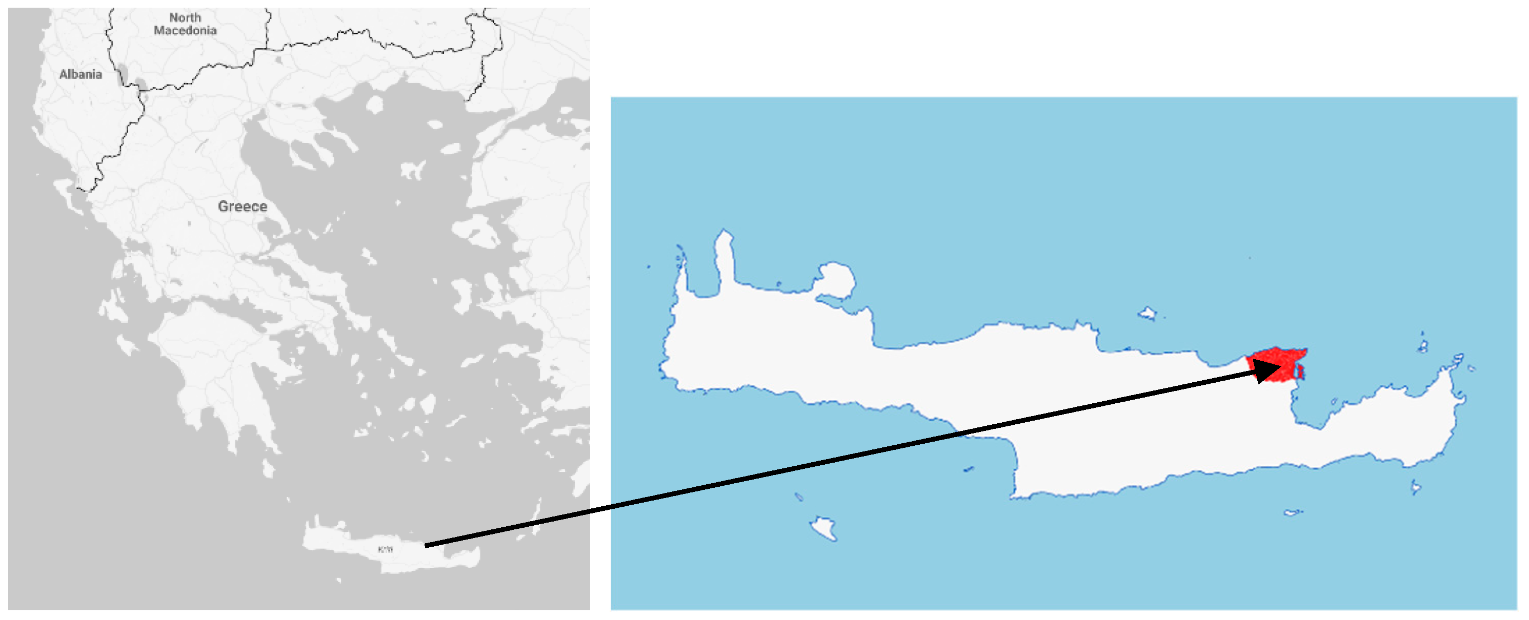
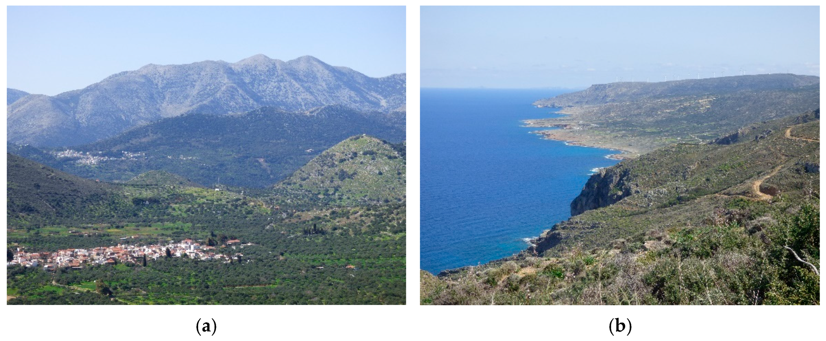
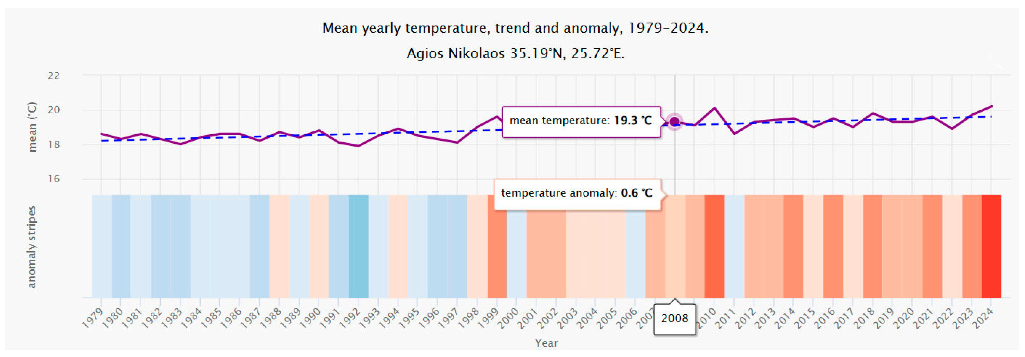
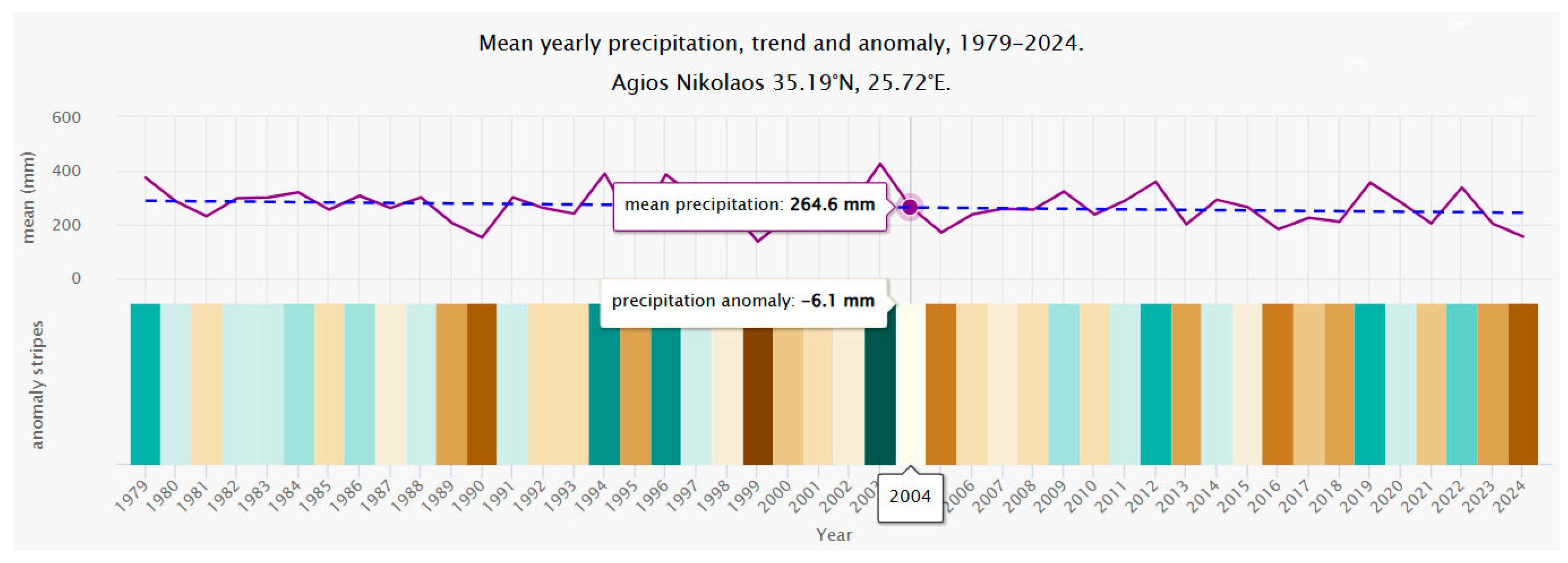
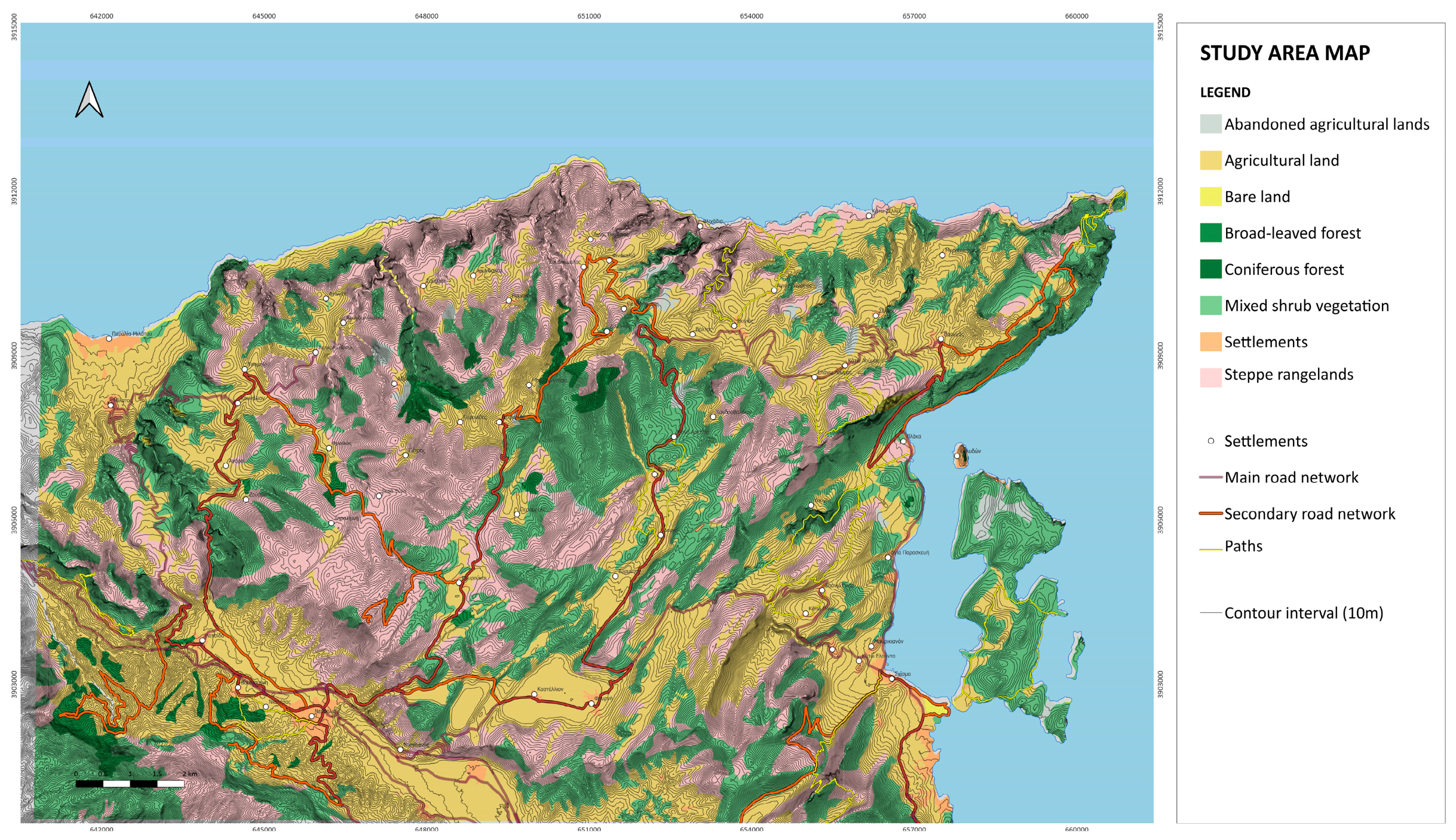
2.1. The Study Area

Ano Mirabello province is located at the northeastern part of Crete (Figure 1), within the Lasithi region, extending from the town of Milatos to Vrouchas and overlooking the Spinalonga harbor to the east. Ano Mirabello is under the jurisdiction of the municipality of Agios Nikolaos. The area covers a considerable portion of Mirabello Bay and is characterized by a mountainous landscape with a few villages situated along its slopes. The landscape is predominantly natural, though shaped by human intervention over the centuries. It is marked by a diversity of terrain that alternates between steep rocky cliffs, small valleys, terraced hillsides, and coastal areas (Figure 2) [24].
It is one of the most tranquil and isolated parts of Crete, where the authentic character of the Cretan countryside is preserved. In the central and eastern parts of the area, there are small valleys where most of the villages are scattered. The majority of these areas are characterized by difficult access and a lack of recent significant human interventions.
Based on data from the Hellenic Statistical Authority (ELSTAT) from the 2021 Census, the population of Ano Mirabello is approximately 2784 residents. According to data from the 2011 ELSTAT Census, less than 10% of the local population is employed in the agricultural sector. In the mountainous regions, more than 50% of residents are retired, while those who are employed are primarily concentrated in the tourist zones, such as Elounda bay.
Wild nature can be found in several coastal and semi-mountainous landscapes of the region, which are important for birdlife [24,25].
The climate is Mediterranean, with hot, dry summers and mild, rainy winters. Average annual rainfall is around 340 mm, which sustains the vegetation but also contributes to water scarcity in the region during the summer months, being one of the driest locations in Crete. Strong north winds are common, especially during the winter [26]. The following graph (Figure 3) presents an estimate of the average annual temperature for the broader Agios Nikolaos region. The dashed blue line represents the linear trend related to climate change. An upward-sloping line from left to right indicates a warming trend, suggesting that Agios Nikolaos is experiencing rising temperatures due to climate change. A flat line suggests no significant change, while a downward slope points to a cooling trend over time. The lower section of the graph displays the “warming stripes”, where each colored stripe corresponds to the average temperature of a specific year—blue indicates cooler years, and red indicates warmer ones.
The upper graph (Figure 4) presents an estimate of the average total precipitation for the broader Agios Nikolaos region. The dashed blue line indicates the linear trend associated with climate change. An upward-sloping line from left to right suggests a positive trend, meaning that precipitation levels are increasing over time, making the area wetter as a result of climate change. A flat line indicates no significant trend, while a downward slope signifies decreasing precipitation, implying drier conditions in Agios Nikolaos over time. The lower section of the graph displays what are known as precipitation stripes. Each colored stripe corresponds to the total precipitation recorded in a given year—green indicates wetter years, while brown represents drier ones.
The region has a remarkable ecological profile, with various endemic plant species and a range of habitats that support unique wildlife. Ano Mirabello’s natural landscape (Figure 5) is ecologically significant, as it contains a variety of plant communities and ecosystems [27]. Three key factors have influenced the current form of vegetation in the area: the climate, intense grazing, and humans. The area belongs to the Mediterranean vegetation zone (Quercetalia ilicis). Two subzones of the Mediterranean zone are found within the study area: the Oleo-Ceratonion subzone in the coastal locations, and the Quercion ilicis subzone in the more mountainous areas [28,29].
The history of Ano Mirabello dates to ancient times, with archaeological evidence suggesting that the area has been inhabited since the Minoan period. During the Venetian and Ottoman eras, it became a key agricultural hub, with terraced fields carved into the mountainside to maximize crop production. By the early 20th century, however, the abandonment of traditional farming practices began to take a toll, and the region’s population began to decline. Nowadays, a lot of agricultural terraces are abandoned, and many of the crops have been replaced by olive groves (Figure 6) [25].
Many mountainous areas have been abandoned by their inhabitants, who have relocated to urban centers and coastal regions. This development has significantly affected the relationship between humans and the land; domesticated animals are rarely seen, and grazing has declined. All of these changes mark the beginning of a new era for the region’s “natural environment” [30].
In the last few decades, the tourism sector has developed rapidly, mainly along the coastal areas of the region and more specifically in Elounda, which has become one of the most popular destinations in the Mediterranean, renowned for its beaches. The mountain villages of Ano Mirabello, however, have not experienced similar development, having a few hotels and guesthouses, but to a limited extent [31].
The architectural character of the region is deeply rooted in traditional Cretan building techniques. Villages feature a unique blend of rural homes, farm structures, and small chapels. The layout of the settlements harmonizes with the natural terrain of the area and may feature linear, circular, or horseshoe-shaped characteristics. The final result blends naturally with the surrounding landscape, especially in cases of stone houses that “disappear” into the rocks [24]. Through continuous use and generational inheritance, these complexes underwent inevitable modifications that significantly altered their original characteristics. As a result, it is often difficult to identify the basic type of buildings, as the changes and adaptations over time have obscured their original form [25].
The architectural identity of Ano Mirabello is also characterized by the “metohia”, small agricultural settlements. The metohia were built scattered, mainly around the villages, to be used seasonally for agricultural activities, as they housed the villagers who worked on the estates of the region’s feudal lords.
The cultural landscape of the area, apart from the settlements and the metohia, is characterized by numerous dry-stone structures, such as windmills, retaining walls, dividing walls and cisterns (Figure 7) [32,33].
The open dry cisterns collect the scarce rainwater and supply the residents who remain in the area with water for both domestic use and the watering of animals and gardens [29,33]. Valuable landmarks are the windmills of the area, built from stone, typically horseshoe-shaped, and organized in clusters or standing alone. Most of them are in a state of ruin, although some have been restored. The quite specific structures such as Apanemidia (Figure 8a), are dry-stone vaulted or semi-vaulted shelters or windbreaks, to accommodate one or two individuals seeking protection from the strong winds in the northern part of Ano Mirabello. The area used to have a network of lookout posts mainly along the coastline, called Vigles, which today are in a ruined state. The region also boasts several significant monasteries and churches, such as the 16th-century Monastery of Aretiou [29] (Figure 8b).
Despite the natural beauty and cultural richness of Ano Mirabello, the area faces pressures from both urban development and tourism. The lack of a comprehensive planning system has led to sporadic and sometimes unsustainable growth, particularly around popular coastal areas. Illegal construction and unregulated tourism development continue to threaten the landscape and its ecological integrity.
Ano Mirabello was chosen as a case study due to its combination of (a) distinctive rural and coastal character, (b) valuable geological, natural, and cultural features, (c) abandonment of traditional agricultural practices with a clear impact on the landscape, (d) socio-economic pressures from tourism and urbanization, and (e) environmental challenges, such as climate-induced desertification and erosion. There is still an opportunity for strategic development planning to protect and enhance the region’s unique landscape and cultural heritage.

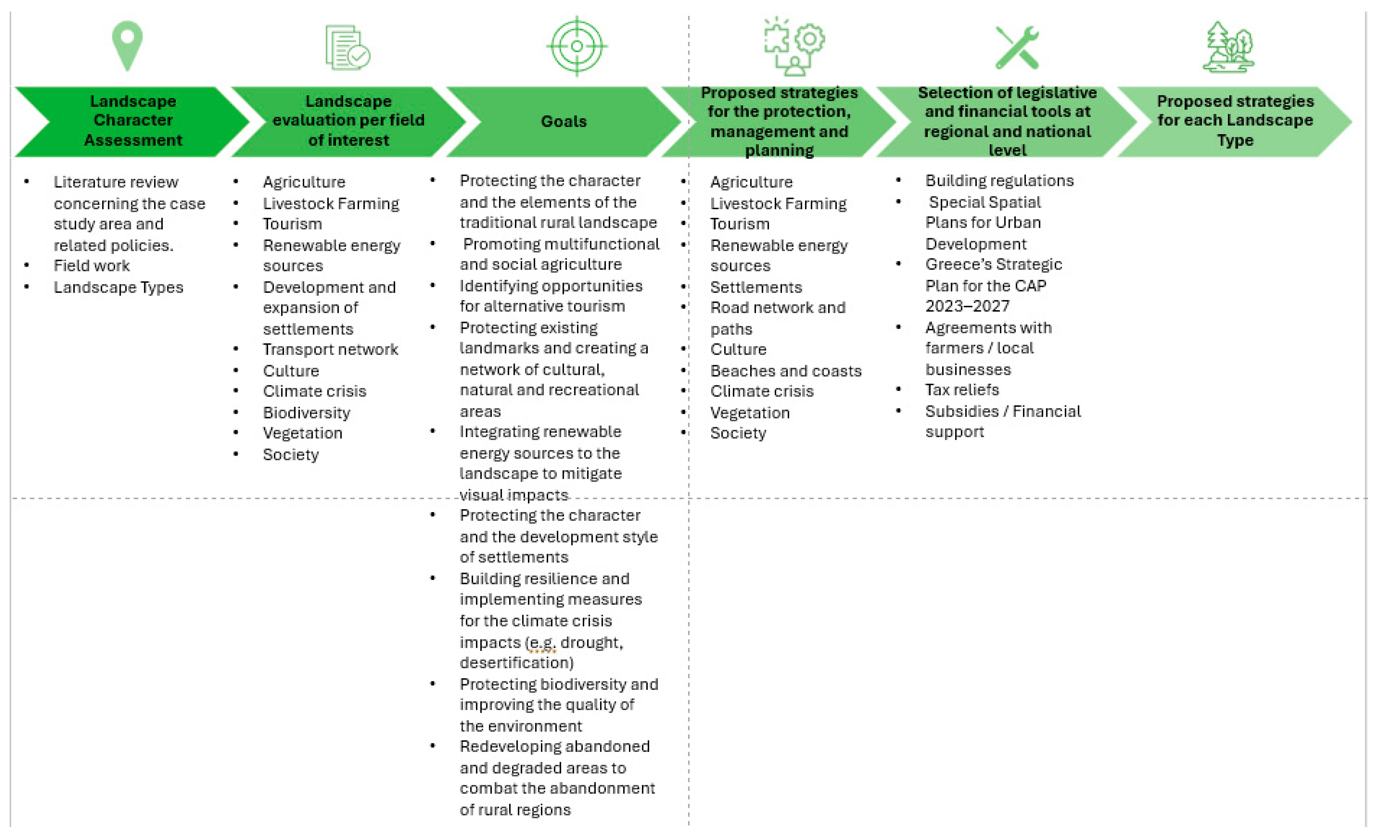
2.2. The Methodological Process

The following diagram presents the methodological steps taken to reach proposed strategies for each landscape character type (Figure 9).

2.2.1. Application of Landscape Character Assessment

The first step was the application of Landscape Character Assessment methodology [34,35,36,37], with the necessary modifications imposed by constraints regarding data availability and resources.
-
Data pre-processing
The collected data were primarily obtained from the publicly accessible website of the Decentralized Administration of Crete and the website of the Ministry of Environment and Energy. Simultaneously, a comprehensive literature review and online research were carried out to gather essential information about the historical and natural environment of Ano Mirabello. This review encompassed data collection on various aspects such as geography, history, ecology, architecture, vegetation, and more, along with the acquisition of maps, technical reports, and photographs.
Primary data were sourced from the geoportal of the Decentralized Administration of Crete and other bibliographical references. Natural elements (topography, geology, soil, land cover, vegetation) were obtained in ArcGIS format from open-access data and scanned at 300 dpi. Cultural elements (archaeological sites, settlements, roads, paths, landmarks) and human activities (settlement expansion, tourism) were also scanned at 300 dpi. These maps were digitized in a GIS environment based on visual interpretation and georeferenced to the Greek natural grid EGSA 1987, with a minimum mapping unit of 1 km2.
-
Mapping procedure
The mapping process, executed in successive steps at a 1:25,000 scale, resulted in the initial landscape units by combining geomorphological data, land cover, soil, settlement locations, and the patterns of agricultural plots in the study area.
Step 1: The dominant landform type within each LDU was identified, informed by geological structure. The main data source was topographic contour maps (10 m or 20 m intervals), supported by Digital Elevation Models (DEMs), Google Earth imagery, and simplified geology and landform maps showing major rock types. Landforms were classified using general geographic and descriptive terms such as mountains, hills, uplands, and lowlands, based on average slope percentage. The first LDUs were formed based on the overlay of topographic contour and geology maps.
Step 2: Soil maps at a national scale 1:100,000 were used, providing a brief overview of indicative soil classes that cover the two essential parameters of soil drainage and fertility. Selective LDU subdivision occurred, unless it seemed really necessary; soil changes will normally show on the vegetation patterns of Step 3 (Landcover) allowing us to make the required subdivisions. However, we used this step to refine landform LDU boundaries, provided that the soil layer was more accurate than the geology.
Step 3: Landcover or vegetation maps from the Decentralized Administration of Crete and the website of the Ministry of Environment and Energy as well as satellite imagery (Google Earth) allowed us to interpret and refine the landcover of the area. An overlay of the provisional LDU boundaries (polygons derived from Steps 1 and 2) onto the landcover base map, helped us to subdivide and characterize the broad landcover categories.
Step 4: Settled areas are classified based on settlement spacing: closely spaced (1–2 km), moderately spaced (2–3 km), and sparsely spaced (over 3 km). Areas with no settlements are labeled as unsettled. Then, this classification was overlayered onto the LDUs from the land cover mapping. Each LDU was characterized by settlement density without further subdivision unless absolutely necessary.
Step 5: Field pattern maps were used based on the data given by OPEKEPE (the Greek Payment Authority of Common Agricultural Policy (C.A.P.)). Field pattern classes such as regular or semi-regular fields with mostly rectilinear boundaries, irregular fields with straight boundaries, sinuous boundaries (always irregular), terraces, wide, terraces, narrow, were used as auxiliary data for the characterization of the LDUs.
Step 6: Data related to archaeological areas, landmarks, road and path networks were added to the final LDUs map and helped in the final subdivision of the Landscape Division Units (LDUs).
-
Fieldwork
The primary goal of the assessment field survey was to verify the information gathered during desktop mapping. The focus is on exploring the LDUs to understand their character and sense of place, taking representative photographs, reviewing and adjusting LDU boundaries, and determining whether any changes are needed, such as adding subdivisions or merging LDUs.
The field survey in the study area was conducted in two periods. The first took place in August 2023, in order to capture the overall landscape character of Ano Mirabello and was mostly as an exploratory visit. The second took place in March 2024 and contributed to the verification and optimization of the initial mapping results, as well as to a more accurate interpretation of the landscape’s character. During the visit, standardized field recording forms were completed, photographs were taken to capture the overall character of the landscape, and specific elements discovered, as well as notable landmarks. In order to understand the LDUs and their character, we used three survey points. One from a distance to obtain an overall view, one from inside to have a direct view, and one at the perimeter for a “border” view. Given the limited financial resources and time constraints, we restricted our survey to roads accessible by car.
First, higher elevation viewpoints were selected to capture the overall character of the area. Then, we navigated through the LDU to understand the sense of place and record the landscape condition. Finally, we completed the field survey sheets and took photographs from selected viewpoints along the main roads. A high-resolution digital camera equipped with GPS was used to make it easier to reference specific locations later. Approximately 1,100 photographs were taken to document the key characteristics and features that contribute to the perceived character and sense of place. The photographs also served to record landscape condition and highlight any other aspects deemed noteworthy, such as particularly beautiful areas or degraded landscapes affected by infrastructure developments (e.g., photovoltaic panels, wind farms, etc.). A field survey sheet guided the collection of field data at each survey point. The survey sheet was tailored to the specific study and provided space for a written description, a checklist of landscape elements and their significance, a checklist of aesthetic and perceptual factors, and space for observations about the sensitivity and management needs of the landscape.
-
Landscape types
The identification of Landscape Character Types (LCTs) was based on the merging of Landscape division units (LDUs) within the GIS database. LCTs were identified by grouping LDUs that shared dominant visual qualities and distinctive local features. This merging resulted in broader, more generalized LCTs that emphasized prevailing landscape characteristics. As a result, some detailed information was intentionally simplified or omitted for clarity and consistency, though it was still incorporated into the narrative descriptions of each type. The synthesis of all the above elements concluded with a landscape typology for the area of Ano Mirabello, whereby all the pressures and potential threats to the landscape were also identified per landscape type. The ultimate goal was to develop key principles (guidelines) for the management and design of each landscape type as well as for the protection and enhancement of the area’s landscape’s character and unique features.

2.2.2. Landscape Evaluation per Field of Interest

During the fieldwork and the literature review, the unique values of Ano Mirabello were highlighted, such as its rich biodiversity and traditional architectural structures, as well as the negative impacts resulting from human activities (e.g., careless planning of photovoltaic panels or wind farms) and other factors. The purpose of these observations was to provide a comprehensive overview of the existing situation, identifying elements that require protection and promotion, as well as problems (as described in field survey sheets) that demand immediate action and strategic planning for sustainable development. From the literature review, regional action plans and relevant studies [31,38,39] were taken into consideration in order to identify the positive and negative aspects of planning per productive sector.
The sectors selected for our research were those that were most prominent in the area, such as agriculture, livestock, tourism, renewable energy, road network development, culture, climate change, society, settlement development, and more.

2.2.3. Goals

The goals of a landscape strategy for the area were formulated in order to preserve and enhance the landscape character and uniqueness, as natural and cultural heritage, for the benefit of the island inhabitants. They address the simple yet complex question: “What kind of landscape do we want for the future?” and reflect the expectations and desires of the citizens, as presented to us by the Regional Governor, the Mayor, Municipality officers, associations, and community representatives. These interviews took place during our field survey visits.
The Landscape Strategy aimed to serve as a foundation for ecological, economically, and culturally sustainable future development, while striving to achieve the following general landscape quality objectives:
Well-preserved and thoughtfully designed landscapes, regardless of type (urban, agricultural, or natural) or character, which are developed through a place-based management model.
Vibrant and dynamic landscapes capable of accommodating inevitable future spatial transformations without losing their identity and their calm, remote character.
Heterogeneous landscapes that reflect the rich diversity of the Cretan landscape, taking into account all aesthetic, perceptual, economic, social, and environmental characteristics of the area, including flora, fauna, geological background, as well as historical and cultural elements of particular value.
Organized and harmonious landscapes that avoid fragmentation and disruption, highlighting existing elements of particular aesthetic and ecological value.
Unique landscapes that are far from being commonplace.
Landscapes that maintain and enhance their references and values, both tangible and intangible (ecological, historical, aesthetic, social usage, productive, symbolic, and identity-related).
Landscapes that always respect the heritage of the past.
Landscapes that convey tranquility, free from discord, noise, and pollution from light or odors.
Landscapes that can be enjoyed without jeopardizing their heritage and uniqueness.
Landscapes that consider social diversity and contribute to the individual and collective well-being of the population, through a combination of educational and recreational opportunities in habitat protection areas and sites of particular geological significance.
The goals were mostly focused on protecting the character and elements of the traditional rural landscape, promoting multifunctional and socially sustainable agriculture, and identifying opportunities for alternative tourism. They also aimed to safeguard existing landmarks while establishing a network of cultural, natural, and recreational areas. Additionally, the integration of renewable energy sources into the landscape will be pursued to mitigate visual impacts. Efforts will be made to preserve the character and development style of settlements, enhance resilience, and implement measures to address the impacts of the climate crisis, such as drought and desertification. The research also focused on protecting biodiversity, improving environmental quality, and redeveloping abandoned or degraded areas to combat the abandonment of rural regions.
At the end, strategies for achieving the above landscape quality objectives were developed by selecting general guidelines and actions applicable to the entire area. Subsequently, the unique character of each landscape was considered, incorporating place-based references to more accurately identify the locations covered by each strategy. The organisation and presentation of strategies were based on the Council of Europe Landscape Convention which promotes landscape protection, management and planning, the UN 17 Sustainable goals, and the guidelines, recommendations from the regional and local spatial plans

3. Results

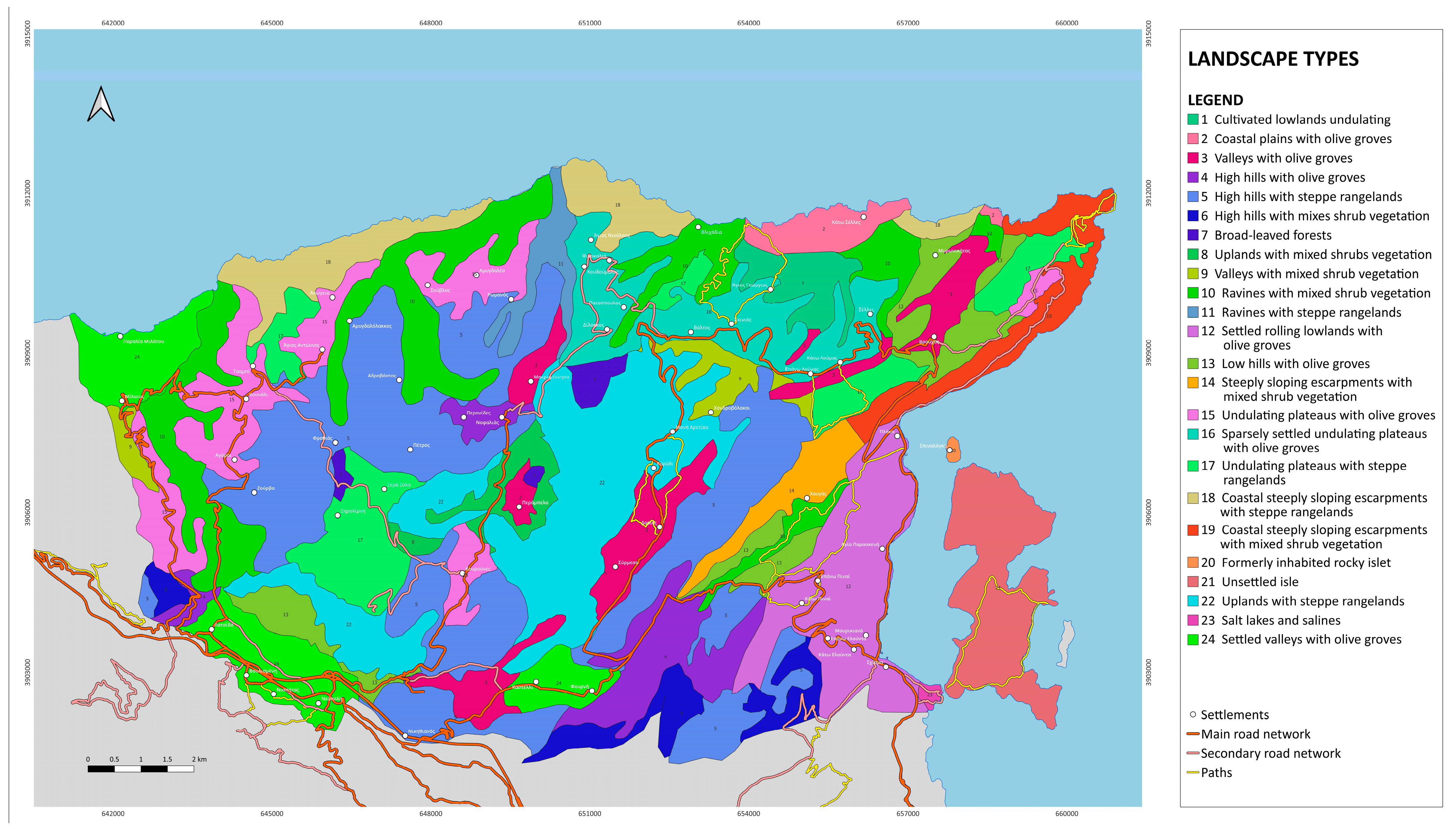
3.1. Landscape Types

The analysis above identified 97 landscape units and 24 landscape types for the Ano Mirabello region. The naming of each landscape type was based primarily on the geomorphology and land cover, with a lesser influence from the presence of settlements (Figure 10).
The identification of landscape character types (LCTs) was primarily conducted based on field observation and experts’ perception, by combining Landscape Division Units (LDUs) within the GIS database, followed by verification during fieldwork. Landscape character types were defined by grouping LDUs with similar visual characteristics and locally distinctive features. Therefore, LCTs could only be defined after a field survey, which incorporated the landscape’s visual qualities into the mapping process [19].
This process led to the creation of more generalized LCTs, which focused on the most prominent characteristics, though some details were simplified or omitted for clarity and consistency. Landform and landcover were the most significant attributes contributing to landscape character. It was thus decided that the combination of landform and landcover would be used as the basis to inform LCT definition. This meant that, for the purposes of the classification, some of the information that had been meticulously recorded during the previous stages of the characterization process were “lost” for reasons of uniformity and simplicity (for example, mixed LDU landcover characterizations might be concealed under a more generalized LCT definition focusing on the most dominant or characteristic use only).
Despite this, relevant information was still incorporated into the description of each type. The observer’s perception during the field survey was emphasized, making the field assessment crucial for interpreting the information in a comprehensive manner.

3.2. Assessment of the Situation in Ano Mirabello

The assessment of the current situation in Ano Mirabello, within the relevant field of interest, was based on the aforementioned work as well as regional and local spatial plans, and led to the following findings:
-
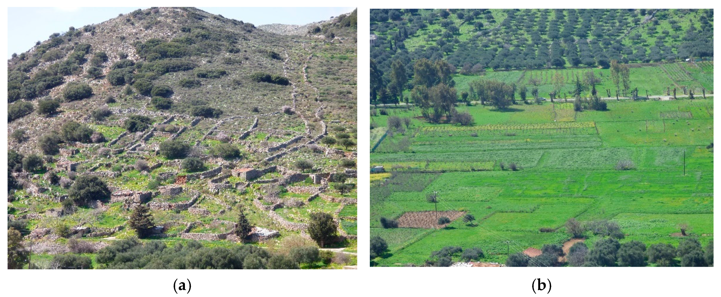
Agriculture: The area is extensively cultivated with olive groves, providing a homogeneous and characteristic agricultural landscape. Unfortunately, most of the dry-stone terraces, which contributed to the preservation of traditional agricultural practices, landscape maintenance, its historical identity, and the region’s cultural heritage are abandoned. As such, the loss of unique features (hedgerows, dry stone constructions, and traditional field patterns), has led to the gradual disappearance of the character of traditional farmland. The appearance of large-scale intensive agricultural facilities becomes more intensive with visual intrusion to dominant locations [40], whereas many infrastructure elements (e.g., photovoltaic panels) have slowly been introduced without any planning.
-
Livestock farming: Overgrazing is notable especially in deserted areas, where the loss of pastures, shrubland and forest areas is evident. The remaining livestock structures do not harmonize with the landscape (e.g., animal shelters) and require careful landscape design guidelines.
-
Tourism: The area of Ano Mirabello is characterized by unbalanced tourism development. Massive tourism development is dominant along the east coastal areas in Elounda bay, attracting most international and national tourists, whereas the mainland and north coastal part remain undeveloped, limiting visitors’ opportunities to explore the region, its traditions, history, and environment. Therefore, the area faces a diversified tourism development, with a landscape decline and environmental degradation due to increased waste, traffic, and vehicle parking along Elounda bay and abandonment of its natural and cultural environment in the mainland.
-
Renewable energy sources: Photovoltaic panels are quite visually intrusive, without proper planning and innappropriate selection of their size [41]. It shows that they are not in harmony with the landscape’s scale, leading to a loss of character. Similarly, the existing wind turbines are visually disruptive into the agricultural landscape, leading to the degradation of the landscape and ridge lines. However, their land cover is still limited and there is space for the appropriate development under specific guidelines.
-
Settlement: The area is characterized by the abandonment of traditional villages, despite some scarce efforts for building restoration based on local architecture. On the other hand, the increase in settlement’s expansion along the east coastline is dominant, with diverse construction styles, housing layouts, non-local materials, and ornamental plants, leading to the loss of their unique character and relationship with the existing natural and historic landscape.
-
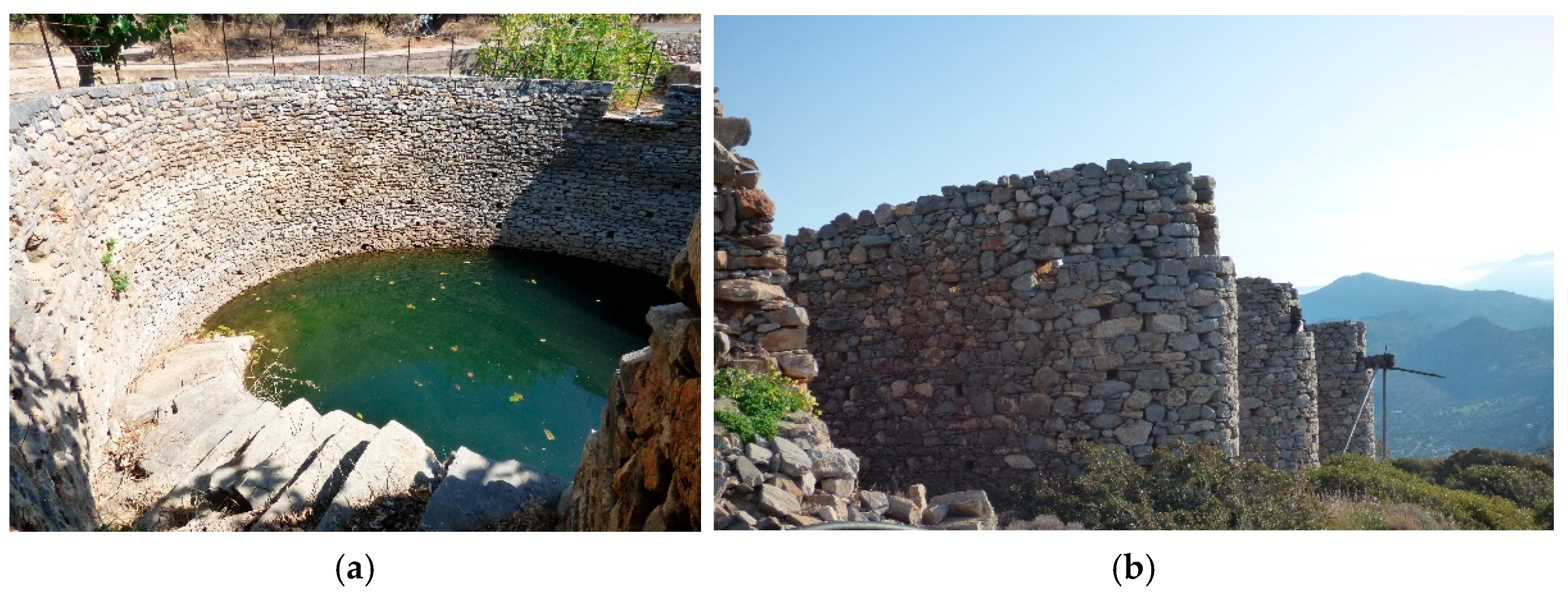
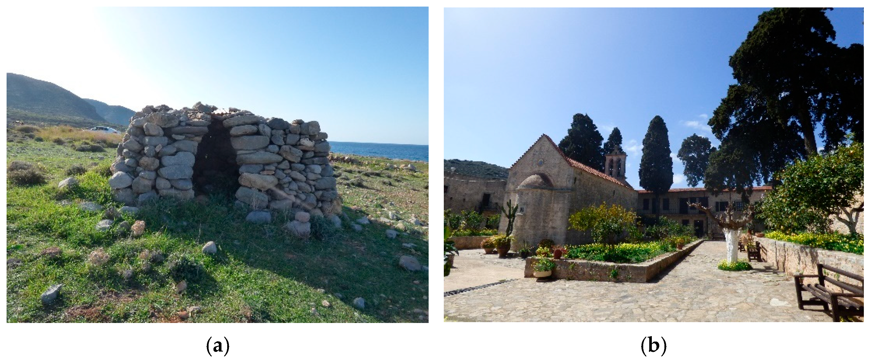
Cultural elements: Most of the archaeological sites including metohia (traditional farm complexes) are neglected. Additionally, important cultural landscape elements such as the windmills, cisterns, and dry stone walls are abandoned and dysfunctional, requiring immediate restoration. There are also historical paths, which although currently lost, offer opportunities for revival and utilization as part of a hiking network, linking cultural and natural points of interest.
-
Natural elements: The area hosts a variety of aromatic plants and endemic species, contributing to the uniqueness and ecological value of the landscape; however, the intensive development and subdevelopment of the area creates a risk of biodiversity loss and reduced income from products such as honey and medicinal and aromatic plants. In addition, rapid and drastic changes in land use and vegetation cover may distort the readability and character of the landscape. Additionally, the increase in development along the coastline will cause a decline of coastal ecosystems.

3.3. Proposed Strategies for Protection, Management and Planning

The main goal for the development of landscape strategies for Mediterranean island landscapes is the preservation and enhancement of their character and uniqueness, as a natural and cultural heritage for the benefit of the island inhabitants and as a foundation for ecologically, economically, and culturally sustainable future development, with the aim of achieving the general landscape quality objectives [20,42,43]. Based on this statement, the strategies were initially developed by selecting some general guidelines and actions for the entire area. Then, the research took into account the particular character of each landscape type. Through the detailed analysis of the natural and cultural characteristics of the area, a deeper understanding was achieved of the elements that constitute the unique landscape character of Ano Mirabello. Through the classification into landscape types, several challenges and opportunities were highlighted, contributing to the development of targeted strategies for the protection, management, and planning of the landscape of Ano Mirabello.
The proposed landscape strategies derived from a combination of the above results and the literature review of the national and local legislative planning frameworks (Figure 7). The strategies are categorized into three types, following the principles of the European Landscape Convention:
Strategies aimed at protection: these include proposals for the preservation and maintenance of the features that differentiate the landscape of Ano Mirabello, justified by their cultural, environmental, and economic value, whether intrinsic or resulting from human intervention.
Strategies aimed at management: these encompass proposals for guiding and harmonizing transformations driven by social, economic, and environmental activities.
Strategies aimed at planning: these involve proposals related to the evaluation, restoration, and creation of landscapes.
A synopsis of specific design guidelines is analytically presented in the following table (Table 1).
The analysis of each landscape type revealed the guidelines that should be followed in a future local spatial plan for Ano Mirabello and specific strategies for the protection, management, and planning of each landscape type is analytically presented in the following table (Table 2).
Planning strategies emphasize the importance of integrating energy and infrastructure systems with agricultural and natural landscapes, utilizing local materials and indigenous plant species. The deployment of photovoltaic panels requires careful planning that respects local identity, guided by established landscape practices and methodologies [41], whereas culture plays a vital role through the careful planning and preservation of a network of historical paths and landmarks.
The management strategies for most Landscape Character Types (LCTs) emphasize the concept of a multifunctional landscape. This approach prioritizes the preservation of native flora alongside the cultivation of olives and aromatic plants. Equally important is the conservation of drystone structures, which help prevent soil erosion and support biodiversity. Overall, the natural environment plays a central and guiding role in these strategies.
Most protection strategies prioritize the restoration of traditional agricultural elements and the maintenance of existing practices, as well as the preservation of cultural features related to water retention. These efforts aim not only to address climate challenges but also to conserve historically and architecturally significant structures (e.g., windmills) and protect the natural coastal landscape.

4. Discussion

The purpose of this research is to highlight the value of the natural and cultural characteristics of a rural border landscape that is facing serious issues of deterioration and desertification. This will be achieved through a Landscape Character Assessment approach, demonstrating how such an approach can lead to planning guidelines for sustainable development. In comparison to previous similar studies, some of which were outlined in the introduction, this research specifically focuses on Mediterranean countries, where LCA remains in the early stages of application. Its aim is to foster greater public awareness of landscape value across all age groups and social backgrounds, and to promote the role of LCA in informing planning and management strategies. This specific methodology proves to be particularly useful for the Greek context, where the application of similar methodologies is lacking, especially in spatial and development planning.
The results allowed the researchers to capture the particular character of the area of Ano Mirabello of Crete. From the LCTs and analysis of the existing situation primary productive sectors, it became evident that specific natural elements, and local architecture with specific landmarks (chapels, archaeological sites, cisterns, windmills, etc.) are the most important cultural traits [44]. However, not preserving the traditional architectural character of the significant historical monuments and archaeological sites dating back to the Minoan era, along with the numerous distinctive windmills and old rural buildings (metohia), will imperil the island’s historical continuity and unique identity. The area’s natural beauty, including beaches and mountainous regions, is a strong draw for visitors. Preserving the natural condition of the landscape provides a unique experience for tourists seeking untouched and authentic places. On the other hand, more sites within the study area are expected to be affected by erosion due to the increased frequency and intensity of extreme weather events, such as torrential rains and strong winds, leading to soil loss and degradation of agricultural land, among other impacts, while some agricultural intensification actions have impacted on the area’s natural resources, particularly the soil and water. A reduction in water reserves for irrigation and domestic use is also apparent. Due to the rapid increase in tourism development along the coastline, the villages in the mainland are not experiencing similar development and most of them are abandoned. This development has greatly impacted the connection between humans and the land; domesticated animals are seldom observed, and grazing activities have decreased. These shifts signal the start of a new chapter for the region’s “natural environment”.
While isolation and insularity present challenges, the remoteness and distance help preserve the traditional way of life and its remaining cultural significance [45]. However, the abandonment of agricultural land also diminishes the scenic and aesthetic appeal of island landscapes, which is vital for the tourism sector. This calls for the implementation of effective alternatives, such as agrotourism, to revitalize local economies in rural villages and inland communities [46].
The findings from the evaluation of the current situation in Ano Mirabello focused on development priorities, which became more specific, aligning well with the landscape strategies and being compatible with various landscape types. As younger members of local communities increasingly choose to work in sectors like tourism, there is a shortage of labor for managing agricultural land. This has led to a decline in small-scale farming and a shift from quality-focused to quantity-driven agricultural practices. Consequently, traditional methods and practices that define the area’s identity are at risk of gradually disappearing. The decline in the permanent population in the mountainous areas of Ano Mirabello results in the weakening of the local economy and loss of connection to the region’s history and roots.
The above results and Table 1 reveal and prioritize the development actions. A proposed solution could be the development of a complex, multifunctional agricultural system with higher added value. This would include the entire production cycle—from primary processing to the sale of products through short supply chains—enhanced by complementary activities such as social farming, and cultural initiatives (e.g., farm excursions, educational farms, agricultural museums). These integrated components could help compensate for potential losses in primary production while fostering more robust and sustainable regional development. The preservation of small-scale farms proved to be essential for maintaining the region’s agricultural heritage. It is also important to integrate agricultural facilities, such as warehouses and machinery, seamlessly into the landscape to minimize their visual impact. Cultivating resilient crop varieties [47] ensures sustainability and adaptability to environmental changes. Equally crucial is the preservation of traditional dry-stone constructions and the planting of small trees and shrubs at field boundaries to promote habitat continuity. Indigenous aromatic plants are a potential agritourism activity for the area around Ano Mirabello [48].
Efforts should also be made to promote historical monuments and celebrate local harvest events, fostering community engagement with the land’s cultural significance. The creation of multifunctional landscapes, where renewable energy sources are incorporated into other productive sectors, is another step toward sustainable development. Proper spatial planning and sizing photovoltaic installations will help balance energy production with the preservation of rural landscapes. Preserving native vegetation in olive tree cultivations is vital to maintaining biodiversity and ecological health. Additionally, fostering a culture of land conservation and rural landscape preservation among residents will help ensure the long-term sustainability of the region. Lastly, the creation of cooperatives can drive economic development by leveraging local traditions and knowledge, ensuring that these practices remain relevant and beneficial to future generations. Efforts to engage young people in the primary sector can be supported through financial incentives and the promotion of agritourism, such as programs focused on learning and applying traditional agricultural practices. Agritourism can also serve as a tool for managing local agricultural resources while providing financial and technical support for renewable energy development [49]. Creating energy communities and offering financial incentives for the restoration of cultural elements in rural landscapes further enhances local development. Collaborations with universities to apply innovative solutions for conservation, alongside public awareness campaigns, can strengthen these initiatives. Additionally, the creation of cooperatives based on local traditions and knowledge can drive economic development in rural areas.
The aim of any strategic plan in the context of tourism development would be to position the microregion as a cohesive destination, offering a comprehensive package of attractions that cater to diverse seasonal and thematic interests. This should ideally be implemented through destination management structures, thereby reinforcing the institutional framework necessary for effective coordination.
The landscape strategies for planning, management and protection for each landscape type as an outcome of the proposed framework of the LCA focus on visual/aesthetic and functional aspects. The above results of Table 2, Table 3 and Table 4 reveal and prioritize the development actions for each of the area’s landscape types. Protecting and conserving the environment is necessary for almost all landscape types. Most of the actions per landscape type were focused on sustainable planning, management and protection of agriculture, natural and cultural environment and settlements.
Restoring buildings and promoting cultural preservation is a key focus for landscape areas that include settlements, isolated historical structures, and features like windmills and cisterns. In the case of limited financial resources, a proposed management plan would begin by protecting a selected number of the most valuable objects or parts of settlements. Preserving and maintaining the unique terraces and other natural elements of the rural landscape is crucial for supporting agricultural progress. Future development, whether in tourism, agriculture, or culture, should prioritize respecting the area’s natural, cultural, and insular identity [50], while also educating visitors about the local environmental and cultural heritage. Furthermore, the outlined development priorities align with the specific landscape types, considering their capacity to accommodate future changes while preserving their authenticity. Consequently, the landscape types defined in this study can function as a reference for overseeing future development in remote areas, serving as essential territorial segments for implementing well-defined, regulated landscape strategies, initiatives, and projects [51].
Here, we revisit and address the main research question of this work, i.e., “to which extent landscape character assessment and the proposed methodological process helped to address the unique needs of remote areas, located at national insular borders of Crete in Greece, with lower levels of development and economic activity, and to conclude to effective strategies for the sustainable development of the particular area”.
The proposed methodology effectively identifies and evaluates landscape characteristics, and aligns with the objectives of the European Landscape Convention, namely the protection, management, and planning of landscapes [52]. This approach can serve as a valuable tool and example for the successful implementation of the Council of Europe Landscape Convention (E.L.C.), particularly in countries where Landscape Character Assessment (LCA) is still in the early stages of application. It demonstrates the importance of LCA in developing landscape strategies for the protection, management, and planning of insular areas.
Simultaneously, the proposed strategies are based on the UN 17 SDGs and present what landscape architects could do in order to implement these goals [53]. Landscape architects focus on transformation, innovation, and resilience to address food security and sovereignty. They prioritize ecological health and adapt education to tackle global environmental and community challenges. Their work helps connect communities and ecosystems, to sustainably protect and regenerate ecosystems, addressing social challenges while benefiting biodiversity and human well-being. It is precisely what the proposed strategies aim to achieve.
The LCA is particularly beneficial for regional and local spatial planning frameworks, as well as special spatial planning frameworks of islands and border areas. It should be applied early in the development planning process and in parallel with a policy program, rather than as an additional step at the end of the process [54].
In Greece, where landscape characterization and assessment efforts are often sporadic and fragmented, tools of this kind are essential for implementing the European Landscape Convention effectively [55,56,57]. These tools can also serve as critical “space regulators” within spatial planning processes, helping to integrate socio-economic and environmental transformations in a balanced and coordinated manner [57].
Future research will focus on adequate public participation methods and tools adjusted to the specificities of the border communities, in order to complement LCA tools and methods.
However, as noted in studies from the UK [58], one of the main limitations in applying LCA is the broad scale at which it is conducted and the absence of clear guidance. While character descriptions are considered especially useful, and an intermediate phase is needed between the assessment and planning stages, where the LCA content can be further developed and specific issues explored in greater depth. This research aims to address this intermediate stage between the assessment and planning phases, and present the strong connections between LCA and landscape strategies. This research provides a comprehensive overview of the topic, and for management or planning related to specific areas such as ecological restoration or agricultural production, more detailed data are required to enhance the assessment and develop more targeted guidelines and strategies.

5. Conclusions

This research suggests different management strategies for different landscape types in a remote island area. The management of these landscapes should prioritize regeneration, blending recreational activities like agricultural tourism and harvesting with institutional revitalization, alongside synergistic development with coastal towns and resort areas, to create a new form of landscape.
This landscape research of Ano Mirabello is being conducted at a critical juncture, as landscapes across the Mediterranean are increasingly under pressure. This is largely due to rapid urbanization, rural abandonment, the climate crisis, technological advancements, tourism growth, economic challenges, and social inequalities, among other factors. In such a dynamic context, the importance of this study is clear. By thoroughly documenting the area’s natural and cultural features, the article has provided a deeper understanding of the unique identity of the Ano Mirabello landscape. The region was classified into distinct landscape character types, which helped to identify both the challenges and opportunities faced by the area. This process has contributed to the development of targeted strategies aimed at the protection, management, and planning of the landscape. The proposed strategies, tailored by field of interest and landscape type, have been enhanced with examples of best practices to emphasize their value.
In relation to CAP 9 strategies, the proposed strategic steps will help towards a fair income to farmers, increase competitiveness and agricultural productivity in a sustainable way, contribute to climate change mitigation and adaptation, foster efficient management of natural resources, preserve landscapes and biodiversity, and protect food and health quality. The methodological approach to strategic steps for management and planning is related to the values and characteristics of agricultural landscapes, associating people with their landscape, enhancing the dialogue and agreement among key stakeholders. This tool facilitates a productive dialogue with locals to create a sustainable future plan for their area.
An essential next step in applying the study and its strategies is the active involvement of local citizens and stakeholders through participatory processes, such as workshops. This will help to identify the pressures on the landscape, the causes of these pressures, their environmental effects, potential future risks, and the preservation of unique cultural elements and traditions. In this way, the study can serve as a vital tool for planning and decision-making, guiding local authorities, designers, and landowners in implementing new policies that will safeguard the area and promote sustainable development. To create more comprehensive and integrated strategies, it is also important to conduct similar landscape studies in the wider region. This would provide a more holistic approach to landscape management across the entire region, considering its unique characteristics. Our findings suggest that Landscape Character Assessment (LCA) is a valuable tool for various sectors involved in landscape planning and management and leads to specific landscape strategies. The main contribution of this research is to offer a roadmap for managers and policymakers on how to utilize LCA, particularly in remote coastal and island areas like the sensitive landscapes of the Mediterranean, to guide their development and manage pressures from various sectors.

Funding

This research was funded by EKPAIDEFTIKI ANAPTYXIAKI PLOIGOS (https://www.ploigos-ea.gr/, accessed on 2 May 2025).

Institutional Review Board Statement

Not applicable.

Data Availability Statement

The original contributions presented in this study are included in the article. Further inquiries can be directed to the corresponding author.

Acknowledgments

The author would like to acknowledge the support given by the board of EKPAIDEFTIKI ANAPTYXIAKI PLOIGOS: the scientific director of EKPAIDEFTIKI ANAPTYXIAKI PLOIGOS and professor at the Technical University of Crete, Nikolaos Skoutelis; Moses Loukas Misthos, geographer and postdoctoral researcher at the University of West of Attica and University of Thessaly; Despoina Giannouri, agronomist and landscape architect (Agricultural University of Athens); and Dimitris Tselifis, agronomist and landscape architect (Agricultural University of Athens).

Conflicts of Interest

The author declares no conflicts of interest. The funders had no role in the design of the study, in the collection, analyses, or interpretation of data, in the writing of the manuscript, or in the decision to publish the results.

References

  1. Jankilevich, C. Food Security, Agriculture and Landscape. In Future of Landscape Architecture Series: Setting the Foundations for Resilient Landscapes and Communities; Marques, B., Ed.; International Federation of Landscape Architects (IFLA) & The Herenga Waka—Victoria University of Wellington: Wellington, New Zealand, 2023; pp. 54–64. [Google Scholar]
  2. Council of Europe. Landscape Convention, Lausanne Declaration on “Landscape Integration in Sectoral Policies”. Available online: https://www.coe.int/en/web/landscape/23rd (accessed on 2 May 2025).
  3. Gkoltsiou, A.; Athanasiadou, E.; Paraskevopoulou, A. Agricultural Heritage Landscapes of Greece: Three case studies and strategic steps towards their acknowledgement, conservation and management. Sustainability 2021, 13, 5955. [Google Scholar] [CrossRef]
  4. CPRE. LANDLINES: Why We Need a Strategic Approach to Land. 2017. Available online: https://www.cpre.org.uk/wp-content/uploads/2019/11/CPREZLandlinesZ-ZwhyZweZneedZaZstrategicZapproachZtoZland.pdf (accessed on 2 May 2025).
  5. United Nations. Resolution Adopted by the GA on 25 September 2015. 70/1 Transforming Our World: The 2030 Agenda for Sustainable Development. 2015. Available online: https://sdgs.un.org/2030agenda (accessed on 2 May 2025).
  6. EC. The Common Agricultural Policy at a Glance. European Commission. 2021. Available online: https://agriculture.ec.europa.eu/common-agricultural-policy/cap-overview/cap-glance_en (accessed on 25 April 2021).
  7. Gkoltsiou, A.; Siakavara, A. Seascape character assessment in Greece. The case of small islands-Gadvos. In The Routledge Handbook of Seascapes, 1st ed.; Pungetti, G., Ed.; The Routledge, Taylor and Francis Group: London, UK, 2022. [Google Scholar] [CrossRef]
  8. Swanwick, C. Landscape Character Assessment. Guidance for England and Scotland; The Countryside Agency and Scottish Natural Heritage: Sheffield, UK, 2002. [Google Scholar]
  9. Donegal County Council. Draft Seascape Character Assessment of County Donegal; Donegal County Council: Lifford, Ireland, 2015. [Google Scholar]
  10. LDA Design Consulting LLP. Dorset Coast. Landscape & Seascape Character Assessment; LDA Design Consulting LLP: Oxford, UK, 2010. [Google Scholar]
  11. Groom, G.; Wascher, D.; Potschin, M.; Haines-Young, R. Landscape character assessments and fellow travelers across Europe: A review. In Landscape Ecology in the Mediterranean: Inside and Outside Approaches, Proceedings of the European IALE Conference, Faro, Portugal, 29 March–2 April 2005; Bunce, R.G.H., Jongman, R.H.G., Eds.; IALE Publication Series 3; FAO: Rome, Italy, 2006; pp. 227–231. [Google Scholar]
  12. Simensen, T.; Halvorsen, R.; Erikstad, L. Methods for landscape characterization and mapping: A systematic review. Land Use Policy 2018, 75, 557–569. [Google Scholar] [CrossRef]
  13. Natural England. An Approach to Seascape Character Assessment; Natural England Commissioned Report; Natural England: London, UK, 2012. [Google Scholar]
  14. Nogué, J.; Sala, P. Prototype Landscape Catalogue Conceptual, Methodological and Procedural Bases for the Preparation of the Catalan Landscape Catalogues; Observatory de Paisage: Olot/Barcelona, Spain, 2006. [Google Scholar]
  15. Vogiatzakis, I.; Zomeni, M.; Mannion, A.M. Characterizing Islandscapes: Conceptual and Methodological Challenges Exemplified in the Mediterranean. Land 2017, 6, 14. [Google Scholar] [CrossRef]
  16. Government Gazette A/30/25 February 2010. Official Gazette L3827/2010. Available online: https://www.kodiko.gr/nomothesia/document/135276/nomos-3827-2010 (accessed on 25 April 2021). (Ιn Greek).
  17. Aldred, O.; Fairclough, G. Historic Landscape Characterization—Taking Stock of the Method; English Heritage: London, UK, 2003; Available online: https://historicengland.org.uk/images-books/publications/hlc-taking-stock-of-the-method/ (accessed on 5 June 2003).
  18. Gkoltsiou, A.; Mougiakou, E. The use of Islandscape character assessment and participatory spatial SWOT analysis to the strategic planning and sustainable development of small islands. The case of Gavdos. Land Use Policy 2021, 103, 105277. [Google Scholar] [CrossRef]
  19. Abu Jaber, N.; Abunnasr, Y.; Abu Yahya, A.; Boulad, N.; Christou, O.; Dimitropoulos, G.; Dimopoulos, T.; Gkoltsiou, K.; Khreis, N.; Manolaki, P.; et al. Travelling in the eastern Mediterranean with landscape character assessment. In Proceedings of the Third International Conference on Remote Sensing and Geoinformation of the Environment, Paphos, Cyprus, 16–19 March 2015; Hadjimitsis, D.G., Themistocleous, K., Michaelides, S., Papadavid, G., Eds.; SPIE: Bellingham, WA, USA, 2015; Volume 9535. [Google Scholar] [CrossRef]
  20. Makzoumi, J.; Pungetti, G. Landscape Strategies. In Mediterranean Island Landscapes. Natural and Cultural Approaches, 1st ed.; Vogiatzakis, I.N., Pungetti, G., Mannion, A.M., Eds.; Landscape Series; Springer: Aberdeen, UK, 2008; Volume 9, ISBN 978-1-4020-5063-3. [Google Scholar]
  21. Makzoumi, J. Olive multifuntional landscapes in Cyprus: Sustainable planning of Mediterranean rural heritage. In Landscape Approaches for Ecosystem Management in Mediterranean Islands, 1st ed.; Conrad, E., Cassar, F.L., Eds.; Institute of Earth Systems, University of Malta: Msida, Malta, 2012; Volume 9, ISBN 978-1-99957-812-1-7. [Google Scholar]
  22. Gkoltsiou, A.; Forczek-Brataniec, U. The Role of Landscape Architecture Profession Recognition in the Context of Facing Contemporary Challenges. Sustainability 2024, 16, 5362. [Google Scholar] [CrossRef]
  23. Cullotta, S.; Barbera, G. Mapping traditional cultural landscapes in the Mediterranean area using a combined multidisciplinary approach: Method and application to Mount Etna (Sicily; Italy). Landsc. Urban Plan. 2011, 100, 98–108. [Google Scholar] [CrossRef]
  24. Center of Environmental Education Neapolis, Crete. Nofalias: Travel to Nature and Tradition; Center of Environmental Education: Neapolis, Crete, Greece, 2007. (In Greek) [Google Scholar]
  25. Apostolakou, V.; Sorou, M. Mirabello: The Place and History (Vol. A&B); Municipality of St Nikolaos, Archaeological Department: Lasithi, Greece, 2023. (In Greek) [Google Scholar]
  26. ΕΜΥ. National Meteorological Service. Available online: https://www.emy.gr (accessed on 27 November 2023).
  27. Kipriotakis, Z. Contribution to the Study of the Chasophytic Flora of Crete and to Its Managment, as a Natural Resource, to the Direction of Ecotourism, Flori-Culture, Ethnobotary and the Protection of the Threatened Plant Species and Their Biotopes. Ph.D. Thesis, University of Patras, Patras, Greece, 1998. (In Greek) [Google Scholar] [CrossRef]
  28. Aggelopoulou, M.; Christidis, C.; Metohi, V. Ano Mirabello: A Landscape Restoration Proposal and Development of Mild Forms of Livestock Farming. Master’s Thesis, Technical University of Crete, Chania, Greece, 2021. (In Greek). [Google Scholar]
  29. Arakadaki, M. Nofalias Mirabello: The Contribution to Architecture of Mountainous Settlements of Crete; Center of Environmental Education Neapolis, Crete: Neapolis, Greece, 2006. (In Greek) [Google Scholar]
  30. Papanastasis, V.P.; Kazaklis, A. Land use changes and conflicts in the Mediterranean-Type ecosystems of Western Crete. In Ecological Studies; Springer: Berlin/Heidelberg, Germany, 1998; pp. 141–154. [Google Scholar] [CrossRef]
  31. Greek Democracy, Region of Crete. Available online: https://2021-2027.pepkritis.gr/wp-content/uploads/2022/02/SEA_CRETE-2021-2027_Final_V02_R01_28102021.pdf (accessed on 3 November 2023). (Ιn Greek).
  32. Goulidaki, M. A Design Proposal of the Municipal Garden of Lasithi, Crete. Master’s Thesis, Technical University of Crete, Chania, Greece, 2011. (In Greek). [Google Scholar]
  33. Skoutelis, N.; Stavroulaki, M.; Maravelaki, P. Cultural routes and rehabilitation of the drystone rainwater cisterns of Epano Mirabello region, Crete. In The Safeguard of Cultural Heritage in the Mediterranean Basin, Proceedings of the 5th International Congress Science and Technology, Istanbul, Turkey, 22–25 November 2011; Crete Technical University Institutional Knowledge Base: Crete, Greece, 2011; Available online: http://purl.tuc.gr/dl/dias/E919CDEF-0B72-4A90-B1F2-DCFDCBCFF524 (accessed on 27 November 2023).
  34. Warknock, S. The Living Landscape Project: Landscape Characterization, Handbook: Level 2. Version 4.1; Department of Geography, The University of Reading: Reading, UK, 2002. [Google Scholar]
  35. Swanwick, C.; Cole, L.; Diacono, M. Interim Landscape Character Assessment Guidance; The Countryside Agency and Scottish Natural Heritage: Scotland, UK, 1999. [Google Scholar]
  36. Vogiatzakis, I. Mediterranean Experience and Practice In Landscape Character Assessment. Ecol. Mediterr. 2011, 37, 17–31. [Google Scholar] [CrossRef]
  37. Vogiatzakis, I.N.; Griffiths, G.H.; Cassar, L.F.; Morse, S. Mediterranean Coastal Landscapes. Management Practices, Typology and Sustainability, Final Report; The University of Reading: Reading, UK, 2005. [Google Scholar]
  38. Paraskevopoulos, G. A Strategic Environmental Impact Assessment Study for the Project: Regional Operational Program, 2021–2027; Report; Region of Central Greece: Crete, Greece, 2022. (In Greek) [Google Scholar]
  39. Kloutsinioti, O.; Katselis, I. Omikron Ltd. Evaluation of the Implementation of Spatial Territorial Plans of Crete; Ministry of Environment & Energy: Crete, Greece, 2011. (In Greek) [Google Scholar]
  40. Siriphanich, S.; Angsuratana, A.; Kalpax, T.; Tepwongsirirat, P. Landscape design guidelines for agro-tourism locations: A case study of Subsanoon visitor center, Saraburi, Thailand. Acta Hortic. 2013, 999, 113–120. [Google Scholar] [CrossRef]
  41. Stremke, S.; Oudes, H.H.; Picchi, P. (Eds.) Power of Landscape: Novel Narratives to Engage with the Energy Transition; NAi010: Rotterdam, The Netherlands, 2022. [Google Scholar]
  42. Vogiatzakis, I.N.; Mannion, A.M.; Pungetti, G. (Eds.) Introduction to the Mediterranean Island Landscapes. In Mediterranean Island Landscapes. Natural and Cultural Approaches, 1st ed.; Landscape Series; Springer: Aberdeen, UK, 2008; Volume 9, ISBN 978-1-4020-5063-3. [Google Scholar]
  43. Oliviera, R.; Guiomar, N. Landscape character assessment and regional landscape strategy in the Azores, Portugal. In Island Landscapes. An Expression of European Culture; Routledge, Taylor & Francis: London, UK; New York, NY, USA, 2017. [Google Scholar]
  44. Pungeti, G. Island Landscapes. An Expression of European Culture; Routledge, Taylor & Francis: London, UK; New York, NY, USA, 2017. [Google Scholar]
  45. Rackham, O.; Moody, J. The Making of the Cretan Landscape; Manchester University Press: Manchester, UK; New York, NY, USA, 1996; Available online: http://ci.nii.ac.jp/ncid/BA29702273 (accessed on 1 December 2023).
  46. Benedeto, G.; Giordano, A. Mediterranean Island Landscapes. Natural and Cultural Approaches; Vogiatzakis, I.N., Pungetti, G., Mannion, A.M., Eds.; Landscape Series; Springer: Sicily, Italy, 2008. [Google Scholar]
  47. Alipour, M.; Jafari, H.; Alizadeh, K. The effect of cultivation of medicinal plants on the economic development of rural settlements Case study: Villages of Kalat city. Propósitos Represent. 2021, 9, e957. [Google Scholar] [CrossRef]
  48. Capucho, J.; Paço, A.D.; Gaspar, P.D. Tourism Related to Aromatic and Medicinal Plants: Some Practical Evidence. Sustainability 2023, 15, 15966. [Google Scholar] [CrossRef]
  49. Teixeira, C.P.; Fernandes, C.O.; Ahern, J. Adaptive planting design and management framework for urban climate change adaptation and mitigation. Urban For. Urban Green. 2022, 70, 127548. [Google Scholar] [CrossRef]
  50. Cheer, J.M.; Stroma, C.; Reeves, K.J.; Kato, K. Tourism and islandscapes: Cultural realignment, social-ecological resilience and change. Shima 2017, 11, 40–54. [Google Scholar] [CrossRef]
  51. Sala, P.; Puigbert, L.; Bretcha, G. Landscape Planning at Local Level in Europe; Landscape Observatory of Catalonia, Government of Andorra: Andorra la Vella, Andorra, 2015. [Google Scholar]
  52. European Commission. European Landscape Convention; ETS No 176; Council of Europe: Florence, Italy, 2000. [Google Scholar]
  53. IFLA. A Landscape Architectural Guide to the United Nations 17 Sustainable Development Goals; IFLA, Universita Polytechnica de Catalunyna: Barcelona, Spain, 2022. [Google Scholar]
  54. The Landscape Institute. Guidelines for Landscape and Visual Impact Assessment; Spon Press: New York, NY, USA, 2002. [Google Scholar]
  55. Symons, N.P.; Vogiatzakis, I.N.; Griffiths, G.H.; Warnock, S.; Vassou, V.; Zomeni, M.; Trigkas, V. Geospatial Tools for Landscape Character Assessment in Cyprus. In Proceedings of the First International Conference on Remote Sensing and Geoinformation of the Environment (RSCy2013), Paphos, Cyprus, 8–10 April 2013; Hadjimitsis, D.G., Themistokleous, K., Michaelides, S., Papadavid, G., Eds.; SPIE: Bellingham, WA, USA, 2014; Volume 87951B. [Google Scholar]
  56. Terkenli, T.; Gkoltsiou, A. Landscape Character Assessment (LCA). Reports of Level 1 & Level 2 for Lesvos, Greece; ΜΕDSCAPES. (ENPI CBC Mediterranean Sea Basin-2007–2013); Department of Geography, University of the Aegean: Lesvos, Greece, 2015. [Google Scholar]
  57. Gourgiotis, A.; Tsilimigkas, G. Landscape Management in Spatial Planning. In Aeixoros. Essays on Spatial Planning and Development; Department of Planning and Regional Development, School of Engineering, University of Thessaly: Volos, Greece, 2014. [Google Scholar]
  58. David Tyldesley and Associates. Fife Landscape Character Assessment; Scottish Natural Heritage: Edinburgh, Scotland, 1999. [Google Scholar]
Figure 1. Location of the study area. Source: Eurostat, GISCO, 2020.
Agriculture 15 01020 g001
Figure 2. (a). A general overview of the landscape of Ano Mirabello. (b). Coastal landscape of the north part of Ano Mirabello. Source: author’s archive.
Agriculture 15 01020 g002
Figure 3. Yearly temperature change in Agios Nikolaos. Source: meteoblue.com.
Agriculture 15 01020 g003
Figure 4. Yearly precipitation change—Agios Nikolaos. Source: meteoblue.com.
Agriculture 15 01020 g004
Figure 5. Study area map 2024. Source: author’s production.
Agriculture 15 01020 g005
Figure 6. (a) Abandoned agricultural terraces. (b) Field patterns of annual crops in a mixture with olive groves. Source: author’s archive.
Agriculture 15 01020 g006
Figure 7. (a) Traditional cistern still in use. (b) A network of windmills. Source: author’s archive.
Agriculture 15 01020 g007
Figure 8. (a) One type of Apanemidia. (b) The monastery of Aretiou. Source: author’s archive.
Agriculture 15 01020 g008
Figure 9. Diagrammatic process of methodology.
Agriculture 15 01020 g009
Figure 10. Map of landscape character types. Source: author’s production.
Agriculture 15 01020 g010
Table 1. Landscape strategies per economic sector for the area of Ano Mirabello.
ProtectionManagementPlanning/Design
AgriculturePreservation of small-scale farms.Providing financial incentives to engage young people in the primary sector.Integration of agricultural facilities (such as warehouses, machinery, etc.) into the landscape.
Cultivation of resilient crop varieties.Seeking solutions through agritourism (e.g., programs for learning and applying traditional agricultural practices).Preservation of traditional dry-stone constructions and planting small trees and shrubs at field boundaries to ensure habitat continuity.
Preservation of traditional agricultural practices.Crop rotation to maintain soil fertility.
Livestock farmingImplementation of rotational grazing systems in zones to address overgrazing. Integration of livestock facilities into the landscape using vegetation and dry-stone constructions.
TourismPromotion of historical monuments.Enhancing tourism in a manner consistent with the area’s character.Providing guidelines for the design of infrastructure and activities related to tourism.
Promotion of harvest events.Developing agritourism as a tool for managing local agricultural elements.Utilization of aromatic plants that grow in the area, offering many opportunities for the tourism sector.
Developing gastronomic tourism.Designing cultural routes that connect the area’s history and tradition.
Renweable energy sourcesConducting Environmental Impact Assessments before installing renewable energy systems.Financial and technical support for the development of renewable energy sources.Creation of multifunctional landscapes where renewable energy sources are integrated into other productive sectors
Creating energy communities.Proper spatial planning and sizing of photovoltaic installations.
Preservation of the open, natural, and rural landscape character by limiting the development of wind turbines, especially on ridge lines.
Settlements Guidelines regarding the architecture of new buildings and infrastructure.
Adoption of policies guiding the proper restoration of existing traditional buildings.
Recognition and promotion of exemplary cases of new building construction.
Road network and pathsRestriction of vehicles in ecologically sensitive areas.Creating a trail network connecting the area’s landmarks.Concealing unsightly land uses visible from the main road network.
CultureProtection of archaeological sites, monasteries, horseshoe-shaped windmills, rainwater tanks, and dry-stone constructions.Awareness programs on the architectural heritage of the region.Appropriate landscape design of archaeological sites to improve accessibility, and harmonization with the landscape.
Financial incentives for the restoration of cultural elements of the rural landscape.Developing a management plan for the archaeological sites in the area.
Beaches and coastsEnhancement of vegetation along water corridors and coasts.Improving the management of waste, sewage, and debris on the coasts.Design and management of coastal access and parking areas.
Climate crisesCollaborations with universities to apply innovative solutions for protection.Utilizing traditional water management practices (rainwater tanks, terraces).
Restoration of rainwater tanks for water storage.Tree-planting programs to combat soil erosion.
Identification of vulnerable areas.
Public awareness campaigns.
Vegetation Monitoring and reducing the spread of invasive species such as Sarcopoterium spinosumEmphasizing the pronounced seasonal changes in vegetation through planning
Preserving native vegetation in olive tree cultivations.The proposed palette of plant species should include endemic species.
SocietyDevelopment of a culture among residents regarding land conservation and rural landscape preservationBetter management and utilization of the area’s aromatic plants
Creation of cooperatives for economic development through local traditions and knowledgeProviding infrastructure to attract digital nomads
Table 2. Landscape strategies for planning per each landscape type of Ano Mirabello.
Fields of InterestStrategies for PlanningLandscape Types
123456789101112131415161718192021222324
Agriculture/Livestock farmingIntegrating photovoltaic panels into existing crops, creating multifunctional landscapes.
Integration of agricultural infrastructures into the region’s landscape through the use of plant material, dry-stone constructions, and appropriate siting.
Integration of new crops, taking into account the existing field patterns and terrain of the area.
Exploration of possibilities for planting small trees and shrubs at the edges and corners of fields to ensure continuity of natural habitats.
TourismPromotion of significant archaeological sites (sunken city of Olous, Mosaic of the Early Christian Basilica of Poros Elounda) and landmarks (Windmills of Poros Elounda, Chapel of Saint Luke) through appropriate development of the surrounding area and visitor information.
Restoration of the Elounda estate complex to an information center for the region and coordinating actions for the development and promotion of the area.
For better integration of tourist facilities into the landscape, it is proposed that planting designs do not follow strict linearity but rather more natural developments, contributing to the unification of different areas.
Renewable energy sourcesCareful planning and selection of the size of the proposed photovoltaic panels, and concealing existing ones with appropriate planting.
Conducting landscape studies for the proper placement of wind turbines, limiting their development to the ridgelines, and choosing locations where the visual impacts on significant views and the local residents will be minimal.
SettlementsThe expansion and organization of settlements should follow the urban planning regulations and provisions of the area, without negatively intruding into the landscape.
Every form of development should be designed and sited so that it integrates into the landscape, considering the views, relief, and natural character of the area, so as not to cause visual disturbance to the landscape and its distinctive features.
Development of traditional settlements such as Finokalia, as an educational and research center for the region, based on the Finokalia Environmental Observatory.
Road network and pathsCreation and enhancement of pathways.
CultureConnecting the significant elements of the area to the broader network of cultural routes that will highlight the history and traditions of the region
Creation of a network of walking routes and connection with the traces of trails dating back to the Venetian period.
Creation of walking routes that will connect the natural, religious, cultural, and historical landmarks of the area.
Connecting the area with the archaeological sites and landmarks located in Kolokytha through the existing walking routes, with appropriate signage.
Beaches and coastsThe coasts should have access, where feasible, through an organized and safe trail network that will create interesting hiking routes.
Natural EnvironmentEnhancement and completion of tree-lined avenues as landscape unification elements (eucalyptus trees between the settlements of Kastelli and Fournis, cypress trees at Monastery of Xera Xyla).
Showcasing the natural wealth of the area through the creation of an organized and safe trail network.
Table 3. Landscape strategies for management per each landscape type of Ano Mirabello.
Fields of InterstStrategies for ManagementLandscape Types
123456789101112131415161718192021222324
AgricultureMaintenance of indigenous vegetation in olive tree plantations for better integration into the landscape.
Promotion of the cultivation of aromatic plants and strengthening of this sector to enhance the local economy.
Provision of financial incentives to allow young farmers to engage in new crops, beyond olive cultivation.
TourismDevelopment of gastronomic tourism combining wine tasting, cooking lessons, and visits to local farms.
Development of a management plan for the archaeological sites located in the area, aiming to make some of them accessible to the public (archaeological site of Driro, Pinos tower, ancient Olous).
Management of visitor access to the island Kolokitha and parking areas, aiming to control disturbance levels, especially during the summer months.
Renweable energy sourcesUtilization of the rooftops of hotels for the installation of photovoltaic panels to avoid increasing the energy burden on the wider area.
SettlementsCompose a maintenance plan for derelict traditional settlements
Road network and pathsHighlighting the existing trails and viewpoints along the route.
Enhancement and improvement of existing walking routes to enable visitors to enjoy the religious and historical monuments.
CultureHighlighting the landscape of the salt lakes and integrating them into a wider network of salt pans in the Mediterranean and Europe, with the ultimate goal of protecting and preserving their historical memory.
Beaches and coastsThe installation of illegal constructions, which dominate the landscape and distort its coastal character, should be avoided.
Waste and wastewater management in the area should be carried out through an organized plan.
Natural EnvironmentMaintenance of dry-stone structures to prevent soil erosion and enhance biodiversity.
Promotion of research programs for the cultivation of experimental fields aimed at enhancing local meadows to limit the spread of Sarcopoterium spinosum.
Maintenance of indigenous vegetation in olive tree plantations for enhancement of biodiversity and landscape connectivity.
Controlled rotational grazing for the restoration of vegetation and eroded soil.
Due to the sensitivity of this specific landscape type, it is important to implement a gradation in access and uses, with the aim of protecting its ecologically sensitive features and mitigating the adverse effects caused by human activities on the landscape.
Systematic monitoring of soil and vegetation conditions to assess the impacts and take corrective measures.
Table 4. Landscape strategies for protection per each landscape type of Ano Mirabello.
Fields of InterstStrategies for ProtectionLandscape Types
1234567891011121314151617#192021222324
AgricultureRestoration of dry-stone structures to preserve traditional agricultural practices.
Protection of the boundaries of cultivated land bordering the settlement of Elounda and establishment of measures for the preservation of fields, which provide a historical continuity to the landscape and enhance local biodiversity.
Avoidance of intensive olive cultivation to preserve the traditional field patterns and terrain of the area, which are adapted to the scale of Upper Mirabello.
SettlementsPreservation of the open, highly visible, and sparsely populated character of this specific Landscape Type.
Any incompatible use (e.g., photovoltaic panels) should be discouraged so that the character of the landscape of this specific type, and more broadly, is maintained, taking into serious consideration the intense alteration the Elounda bay has undergone.
CultureRestoration of rainwater collection tanks to promote the region’s historical heritage and to strengthen water management.
Restoration and highlighting of the horseshoe-shaped windmills of the area.
Restoration and utilization of the metochia.
Preservation of the character of the historical and natural landscape of Spinalonga as well as the surrounding coastlines through adherence to landscape protection provisions and urban planning regulations for the area.
Beaches and coastsPreservation of the natural and wild character of the coastal steep slopes and shores, preventing any form of massive tourism development.
Natural EnvironmentRestoration of existing inactive quarries north of the settlement of Latsida.
Protection of the wetland of the salt pan area with a specific management plan.
Protection and management of broadleaf forests due to their uniqueness within the landscape.
Disclaimer/Publisher’s Note: The statements, opinions and data contained in all publications are solely those of the individual author(s) and contributor(s) and not of MDPI and/or the editor(s). MDPI and/or the editor(s) disclaim responsibility for any injury to people or property resulting from any ideas, methods, instructions or products referred to in the content.

