Article

Agricultural and Industrial Heritage as a Resource in Frontier Territories: The Border Between the Regions of Andalusia–Extremadura (Spain) and Alentejo (Portugal)

by
Ainhoa Maruri Arana
* and
María Teresa Pérez Cano
Department of Urban Planning and Territorial Development, University of Seville, 41004 Seville, Spain
*
Author to whom correspondence should be addressed.
Agriculture 2025, 15(9), 956; https://doi.org/10.3390/agriculture15090956 (registering DOI)
Submission received: 31 March 2025 / Revised: 24 April 2025 / Accepted: 25 April 2025 / Published: 28 April 2025

Abstract

:
The border effect on heritage protection, shaped by historical and physical factors, contributes to the formation of socio-territorial systems, particularly in relation to productive landscapes. This study focuses on the Portuguese–Spanish border between Andalusia and Extremadura, a region where inter-regional dynamics mirror international tensions due to the coexistence of differing legislative frameworks. The area is characterized by shared agricultural and ecological systems and fragmented transport networks, which complicate territorial integration. Methodologically, the study involves a selection of seven municipalities based on demographic vulnerability and rural identity, followed by historical and spatial analysis using legal sources, historical dictionaries, and digital platforms for heritage mapping. One of the key components was the identification and documentation of historical mills linked to the Ardilla River and its tributaries, using a combination of official heritage databases and user-generated platforms like Wikiloc and local websites. The twenty-one mills found highlight a significant presence of unprotected yet generally well-preserved mills that exemplify the agricultural and industrial legacy of the region. These assets, often overlooked in formal inventories, underline the potential for cross-border heritage recognition and call for a rethinking of protection strategies through the lens of cultural landscapes and community engagement.

1. Introduction

The economy of the Iberian Peninsula, both in Spain and Portugal, has been characterized by its rurality and by its agricultural and livestock activities, in which a large part of the population was occupied. However, with the changes of the second half of the twentieth century, the transformations have led to the rise of cities, leading to a problem of depopulation or aging in some areas. Moreover, in these places, there is less and less knowledge of rural areas and of the activities and heritage linked to them [1]. Although these areas hold important cultural and natural value, they are often overlooked by both planning policies and heritage laws. This is largely due to the undervaluation of such assets, which stems from the limited recognition given to agricultural activity [2], and for this reason, the decision was made to explore this topic from a perspective that moves away from the focus on case studies in major cities.
In addition, with the factors of the physical environment and the impact of the different civilizations that have marked its territory, a dynamic interchange of thousands of years has been fostered between the physical-environmental context and the social and economic situations. These socio-economic conditions have allowed, throughout history, a certain distance of this rural territory from the generalized process alteration of the environment. This occurs mainly in a large portion of the Spanish and Portuguese states, which has allowed the identity to remain somewhat unchanged. Nevertheless, it faces great challenges, such as low population density and low degree of industrialization. The traditional land use systems, based on large landholdings, have also contributed to this, in addition to the low densification of roads [3]. This problem is significantly sensitive in border areas where different administrations converge and are usually far from the main cities.
The border is a spatial set whose military, economic, fiscal, or administrative characteristics vary according to space and time, which, if we speak in terms of identity, is presented as a whole as a result of geophysical issues and historical evolution. The regions have tried to resolve border conflicts by means of precise delimitation and collaboration agreements to ensure good inter-territorial relations [1].
The approach to heritage through its relationship with the territory is something recent, since previously, only the monument was protected in a unitary way; later, it was passed to the historical ensemble, later to the cultural and natural heritage, and finally, in the cultural landscape [4], which has its consequence in the European Landscape Convention of 2000 [5]. However, on many occasions, it has not been understood that the cultural landscape is something continuous and cannot be divided between administrations, which generates a border effect that hinders the protection of heritage linked to that territorial basis. This circumstance often refers to those that Spain has with other countries, such as France, Andorra, or Portugal, but in Spain, there is also the circumstance that, due to the transfer of competences to the Autonomous Communities, there is also a border effect between them.
It should not be forgotten that the border is a heterogeneous reality where numerous flows of different natures occur. Its real space does not usually correspond to that mapped on maps, plans, or drawings of its representations made by the agents working in this delimitation. The border is a zone and not a line, which is articulated around a set of central places on each side of the dividing line that interact with each other and develop their own dynamics [6]. Therefore, the study suggests making an effort to recognize these rural frontier spaces, in addition to promoting their recovery, in order to progress in the search for future sustainability and the internal restructuring of the territory. Furthermore, this issue could be in tune with the need to rebalance the territory in general, understanding that the population growth dynamics of the cities are not detrimental to the rest of the territory and, therefore, impact the rural area and are common in the present demographic imbalances. For this reason, it is imperative to safeguard these places through their appreciation by societies and cultures, given that they could be transformed into a vital resource [7]. It is important to consider that the suggestions that strengthen the position of heritage can contribute to strengthening territories with vulnerabilities, focusing on new sustainable opportunities, given that heritage is a resource for development [8].
The end result is reflected in the work area in what is currently perceived as a valuable legacy of formations and species of flora and fauna, and, consequently, of landscapes. These landscapes, with their structure and composition, are, in their origin, cultural landscapes. This is because, as in the historical and geographical context of the Mediterranean civilizations where the area to be worked on is located, they could not be understood through an exclusive study of any of the elements of the man–environment binomial.
Specifically, we have chosen to work with the agricultural heritage, legacy of rurality, and agricultural or livestock activities that have characterized the territories of the peninsula. This heritage has not been recognized until recently, and therefore, the definition of Agrarian Heritage is taken from the definition of the Baeza Charter on Agrarian Heritage and is taken as a reference: “Agrarian Heritage is made up of the set of natural and cultural, tangible and intangible assets, generated or used by agricultural activity throughout history” [2]. Nevertheless, it is increasingly recognized, for example, by Unesco, such as the olive grove of Andalusia, which is under study for inclusion in the World Heritage List, or by the population itself, which asked the Junta de Andalucía to protect the Vega de Granada as a BIC, and this was not done [9]. However, despite their relevance and the significance of their cultural and natural values, they are not adequately treated either by planning instruments or by heritage legislation, due to the undervaluation of these assets, largely because of the little consideration given to agricultural activity [2]. To this must be added that despite this heritage recognition of agricultural assets, in most cases, their agricultural value is not taken into account, but rather other values such as artistic, historical or technical, which means that their protection is not adequate [9].
For this reason, it has been decided to work with an example of the assets of the productive legacy, the mills, that are located in the transboundary work zone and of low population density, which, as will be seen, are assets that are not protected, so they are in danger of destruction and loss of historical legacy, which is why it is important to identify and recognize them. Nevertheless, the protection of traditional mills in Europe has gained increasing attention within the broader field of rural and industrial heritage, particularly as awareness grows about the cultural, historical, and territorial values of these structures. However, despite their significance, many mills—both wind- and water-powered—remain under-protected and insufficiently documented, as some initiatives such as the European Heritage Label, the RE-USE Project (Interreg), or the ERIH network tend to focus on larger or more iconic sites, leaving smaller rural assets less visible. At the international level, The Faro Convention [10] underscores the societal value of cultural heritage and calls for community involvement in its preservation. Mills fit well within this vision, embodying local identity and traditional knowledge. Similarly, the TICCIH Charter [11] emphasizes the importance of industrial sites like mills as part of broader productive landscapes, while the widely respected Burra Charter [12] reinforces the protection of places with layered historical and cultural significance and supports the recognition of mills as both tangible and intangible heritage, deeply embedded in rural cultural landscapes.
The academic literature further contextualizes the value and perception of mills within heritage studies. Biel et al. [13] emphasize the challenge of integrating cultural heritage into sustainable development, stressing the need for adaptive reuse of rural assets. Strangleman [14] critiques the nostalgic framing of decaying industrial sites and calls for more meaningful representations that connect communities to their heritage in active ways. These approaches are highly relevant when considering how mills might be protected—not simply as static relics, but as dynamic elements of living landscapes.
At the national level, efforts vary widely. In the United Kingdom, the Society for the Protection of Ancient Buildings (SPAB) has established a dedicated Mills Section [15], producing regular inventories and engaging in restoration advocacy. The Netherlands, known for its iconic windmills, protects many such sites through national heritage listings and has succeeded in securing UNESCO recognition for ensembles like Kinderdijk [16].
In Spain and Portugal, the case study countries, the protection of mills remains fragmented. Though portals like the Guía Digital del Patrimonio Cultural de Andalucía and Portugal’s DGPC database provide some inventorying, there is still a lack of systemic recognition. The reliance on alternative data sources such as Google Maps, Wikiloc, and local village websites by researchers highlights the urgent need for formal protection and coordinated documentation efforts, particularly in cross-border basins such as the Guadiana.
Therefore, the approach has been adopted to address the challenges of properly understanding and protecting these agricultural assets within the framework of various legislations in a cross-border context. The ultimate aim, for future studies, is to explore ways of reactivating these areas through their historical legacy. While similar efforts have been made before, they have either not focused specifically on agricultural heritage [17], or have not considered the cross-border dimension [18], which is particularly significant, as legal boundaries are real, yet the landscapes and cultural assets they contain are continuous and do not conform to administrative limits.

Objectives

The article proposes to expose, through the inventory of the mills in the selected municipalities, the difficulty of their adequate understanding and protection by the different legislations in a cross-border context.
Its specific objectives include the following:
  • To identify and examine legal frameworks and territorial disputes between countries and Spanish Autonomous Communities, in order to assess how these influence the protection and management of heritage assets in border areas.
  • To analyze spatial data and territorial boundaries within the study area, with the aim of illustrating the disconnect between administrative borders and the continuity of cultural landscapes.
  • To investigate the historical and current role of rural productive systems—particularly agricultural structures—as a basis for understanding their cultural and territorial significance.
  • To compile, geolocate, and classify existing mills within the study area using fieldwork and archival data, in order to evaluate their distribution, typologies, and current condition.
  • To develop informed protection strategies for the identified heritage assets, based on their cultural value, spatial patterns, and vulnerability within a cross-border context.

2. Materials and Methods

After a bibliographic review, and with the aim of exposing the difficulties that occur when protecting this agricultural heritage in a territory with different legislation and management, despite being a continuous landscape, we have sought to expose initially what the border means and what we understand by it, contextualizing its origin and definition and the inequalities that occur in terms of protection or management of natural or cultural heritage and the framework legislation of each administration in the area. As said, this circumstance refers to those that Spain has with Portugal; due to the transfer of competences to the Autonomous Communities, there is also a border effect between the Spanish regions, for instance, between Andalusia and Extremadura (Figure 1).
In particular, the border case study between Portugal, Extremadura, and Andalusia is sparsely populated and has major repopulation problems due to its peripheral position within the state, international, and regional economic systems. Moreover, they belong to the provinces and districts with the lowest levels of employment and income in Spain and Portugal and, in some cases, also in Europe. The presence of the regional and national boundary is also a problem due to the border effect caused by the transfer of competences and the development of the regional policy of the Autonomous Communities within the framework of the State of Autonomies [19]. All the problems and dysfunctionalities affecting these interstitial spaces are greater when the areas are economically underdeveloped, which especially affects the border area between Huelva, Badajoz, and Alentejo, where three different administrations converge (Figure 1). This area has always been a continuity solution between the Portuguese Baixo Alentejo and Sierra Morena, so that although it was a common geoeconomic space, its development possibilities have been reduced and demographic depression has been accentuated. With all of the above, along with the historical, physical and economic factors, a situation of continuous demographic loss has been reached [20].
Subsequently, we have sought to define the territorial structure on which the heritage to be studied is based, including all those elements that make up the natural environment and those that were introduced by man, such as infrastructures. Next, the productive work that takes place in that area has been exposed, as an important part to understand in order to recognize the context in which the assets to be studied are built. Both the physical and the productive framework have been represented cartographically through the Geographic Information System QGIS with the bases of the Cartographic and Statistical Institutes of both countries, which has entailed certain difficulties since there is no cartographic base for the whole Iberian Peninsula, in spite of being recognized as a unitary element.
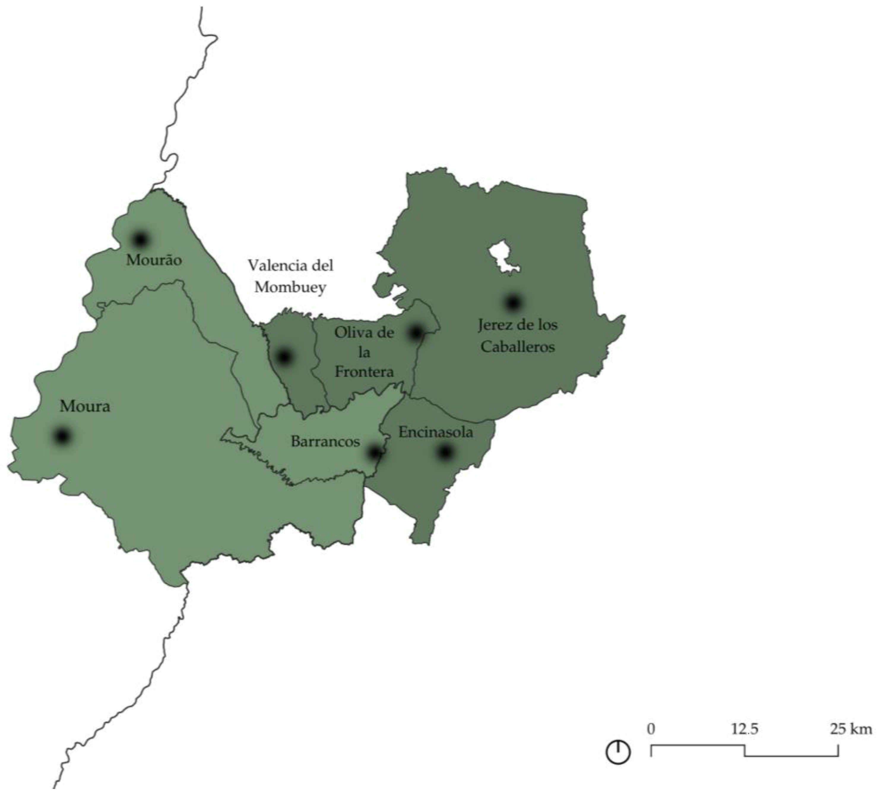
In order to better explain what we are looking for here, we have worked with a specific case study, which includes the area that includes the municipalities of Encinasola, Oliva de la Frontera, Jerez de los Caballeros, and Valencia del Mombuey on the Spanish side, and Moura, Barrancos, and Mourão on the Portuguese side (Figure 2). In addition to being cross-border at the international level, they are also cross-border between regions—such as Andalusia and Extremadura—and between Portuguese districts (those of Central Alentejo and Baixo Alentejo). However, the border effect is greater between Spanish Autonomous Communities, as we shall see later, due to the different regional legislations.
Precisely, this area is highly unstructured due to the low population density, the lack of medium-sized cities, the fragility of the rural population structure—which generates extensive unstructured rural areas—and the presence of a road system that favors external connections.
At present, a solution to this situation is being sought for rural areas through land use planning, which is very difficult in the specific area of work due to the intervention of several administrations, and therefore, they continue to have a depopulation process, especially in mountain areas and disadvantaged agriculture, among which is the territory of work. And that is precisely why this area of work has been chosen specifically because it includes not only conflicts between countries, but also between regions of the same country, but belonging to the same physical environment, such as the Guadiana River Basin. In addition, in a generic way, all the municipalities have a situation of population loss and aging, which makes them vulnerable, making it necessary to work in this type of nuclei to avoid their abandonment and consequent loss of identity.
Once the municipalities in which work was to be done had been decided, and after having explained the legal, physical, and productive framework, the relevance of recognizing the Agrarian Heritage was reinforced by reviewing what was said about those same municipalities in the two reference books of the time: the Diccionario geográfico-estadístico-histórico de España y sus posesiones de ultramar, by Pascual Madoz [21] and the Diccionario geográfico-estadístico de España y Portugal, by Sebastián Miñano y Bedoya [22]. In them, there is a brief description of the production and industry of the time, which allows us to identify how important these assets were for the time and compare it with the present in most cases, with the exception of the municipality of Barrancos, which does not appear in the corresponding document. Within the industrial section, in the case of Madoz’s document, we recognize how many mills there were in each of the nuclei, highlighting how important these properties were for the economy of the time. At present, these assets are part of the productive legacy of the time and that is why it is decided to identify and recognize them territorially in the different areas since their existence in this territorial set makes it a very successful example to expose the ways of life in the countryside and the changes experienced by our society in recent decades [23].
With this, we proposed a a mapping of the immovable assets, such as the mills linked to the Ardilla River and its tributaries, within the framework of the Guadiana River Basin. It is understood that leaving aside how a sectorized protection does not help the understanding of a heritage system that could be recognised as a Cultural Landscape or as a Site of Ethnological Interest as a whole, since it is intrinsically linked to its territory. As the mills are neither protected nor inventoried at present, neither in Spain nor in Portugal, the locations have been obtained from the Guia Digital website of the Andalusian Institute of Historical Heritage (https://guiadigital.iaph.es/, accessed on 30 March 2025), the website of the Cultural Heritage of Portugal (https://www.patrimoniocultural.gov.pt/instituicao/apresentacao/, accessed on 28 March 2025). If the mills were not found there, they were identified from Google Maps, the websites of the villages, and Wikiloc—from the hiking routes shared by people. Moreover, additional information about the mills was sought; however, in some cases, it was not accessible. The sources consulted included online newspapers and personal websites, where the information was often shared by individuals rather than official institutions, in relation to the popular character of this type of heritage (Figure 3). It is therefore recognized that the study should be expanded and continued in the future, with other examples of productive heritage and with a deeper information of the study mills—such as fieldwork images.

3. Results

3.1. Settlement Framework

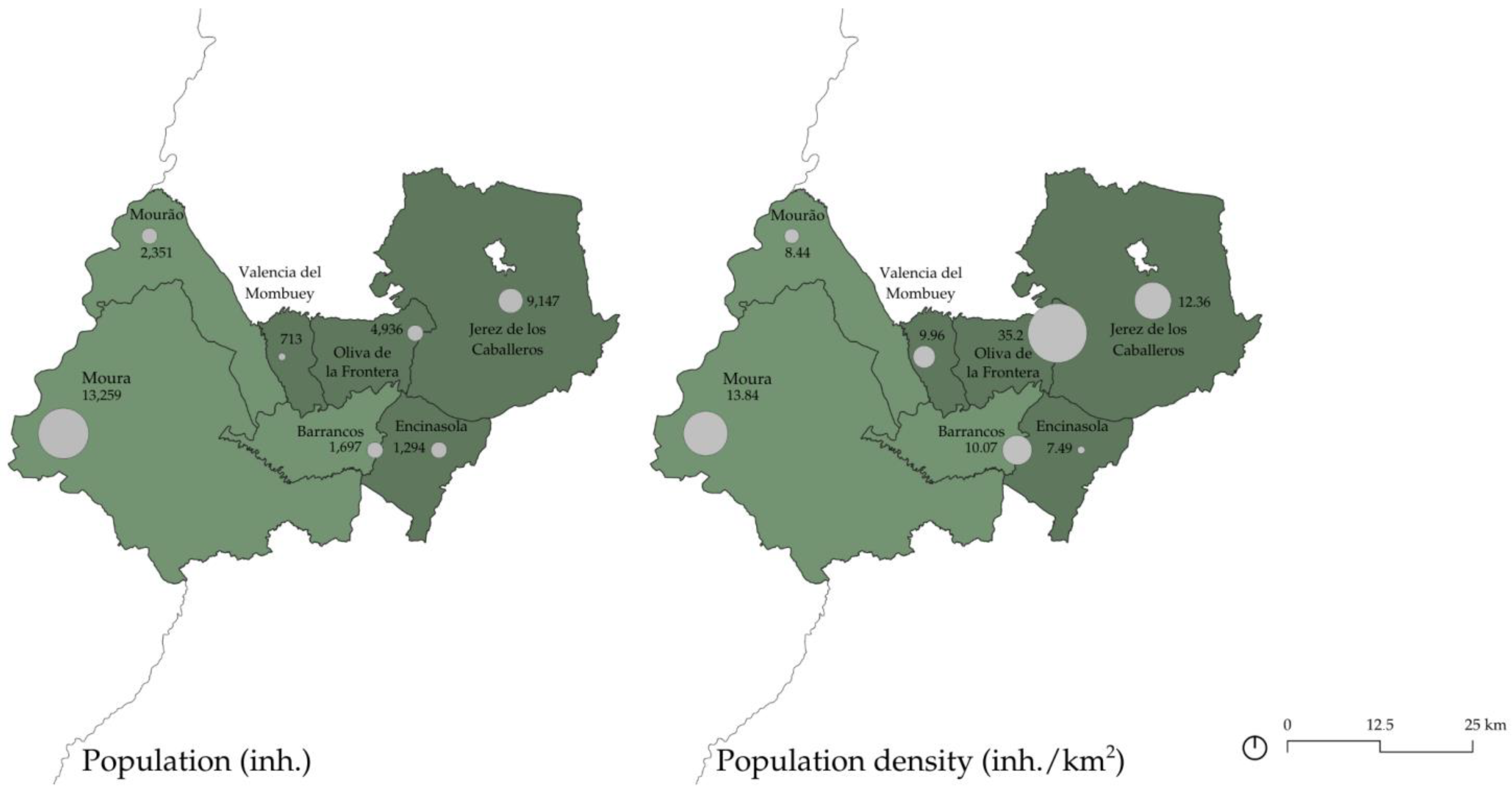
The nuclei of study, in addition to being on the border, are municipalities with low population densities, which implies a general abandonment of the heritage in these places. The population densities in the work area have been quite low throughout history. The ongoing demographic decline stems from the historical processes of reconquest and repopulation, which have been shaped over time by the difficulties in establishing a productive zone in the region. In addition, the demographic problems have been pronounced during the 1950s, 1960s, and 1970s due to the great rural exodus that occurred throughout Spain. As a result of all of the above, the demographic structure has been affected, showing clear symptoms of an aging population, which is the first obstacle to its survival in the short-to-medium term [4]. In addition, the most depopulated rural areas tend to have the highest percentage of an aging population, due to the migration of young people to other towns or county seats, and fewer women, characterizing the rural environment [24].
The population structure follows a regressive pattern—as in the case of the states in general—but with a less youthful profile, which is a serious risk for the region. Therefore, demographic depression is one of the factors that define the study area (Table 1, Figure 4). This situation is due to the aforementioned physical and historical factors, which have been aggravated by the massive exodus to provincial capitals or developed cities between the 1950s and 1970s [19]. This problem does not occur in people of the same age or sex: it is the younger generation that emigrates, leaving the human potential unrenewed and the aging of the population, which in the short-to-medium term, will cause great problems of depopulation.

3.2. Legal Framework

Before proceeding to the exposition of all the elements that affect the border territory under study, it has been deemed necessary to make a reference to what is understood by the border and why it occurs in this context and the need to work on it, exposing the legal framework in which it is inserted.
Precisely, in Europe, the highest intensity of cross-border cooperation projects is located precisely between the borders of Spain and Portugal, and those of Austria and Germany, and those of Austria and Italy, with more than 300 projects in each INTERREG program [25]. Moreover, the Spanish–Portuguese border is the largest European border—1234 km—but it is considered one of the least prosperous, despite the fact that cooperation started as early as 1989–1993 [26]. Currently, the framework for cross-border cooperation with Portugal is the Treaty between the Kingdom of Spain and the Portuguese Republic [27] on Cross-border Cooperation between Territorial Entities and Bodies, signed in Valencia on 3 October 2002. As has already been seen, the two Spanish Autonomous Communities chosen for the development of the study are bordering the Portuguese country, and their cross-border cooperation is carried out within this framework. In addition, these regions have numerous tools and agreements to satisfy the cooperation between both sides of the Raya, despite the fact that the exclusive competences in international relations belong to the State. Nevertheless, the possibility is left for the Autonomous Communities to carry out external actions.
On the one hand, in the Directorate General for External Action of Extremadura, for example, there is the Cabinet of Cross-Border Initiatives, which has been working since 1993 to promote proposals that lead to the permeabilization of the border. Among others, there are heritage dissemination activities, such as publications related to historical heritage or the preparation of tourist-divulgative guides on popular festivals, routes along the Raya, the heritage cities of Évora and Mérida, gastronomy, etc. [28]. This has been thanks to certain tools of their own, to protocols accepted by both countries—such as the protocol between Alentejo, Centro Region, and Extremadura (1994)—and to funding coming from the European Union that allows border cooperation and the permeabilization of the territories. Also noteworthy is the Alentejo–Centro–Extremadura Euroregion (Figure 5), which seeks to focus on priority areas of cooperation [29].
In Andalusia, the General Secretariat for External Action of the Ministry of the Presidency is in charge of coordinating and providing general advice on the actions of the Regional Government of Andalusia abroad [30]: among others, for example, the development and updating of the agreements signed with the Algarve–Alentejo regions, promoting cross-border cooperation. Another of the fundamental precedents for institutional cooperation is the Alentejo–Algarve–Andalusia Euroregion (Figure 5)—institutionalized in May 2010—to promote a more advanced stage of cross-border cooperation, which aims to become a living space for participation [31].
What is proposed here is the study of the separation between the limits of both national and regional boundaries, since between them there are interactions between the central and peripheral forces of the border municipalities that do not always coincide with those used by the traditional groups that play an important role [6]. For example, the border between Spain and Portugal has been very variable throughout history, so that its current delimitation may not respond to the construction of what we recognize today as heritage, and the same happens between Autonomous Communities, specifically between Andalusia and Extremadura, whose dividing line has also fluctuated throughout history.
Precisely, in Spain, there is no interregional protection of cultural heritage, but it does happen with natural areas that can influence more than one Autonomous Community, as indicated in Article 149 of the Spanish Constitution: “The legislation, management, and concession of hydraulic resources and uses when the waters flow through more than one Autonomous Community, and the authorization of electrical installations when their use affects another Community or the transport of energy goes beyond its territorial scope” [32]. This happens, for example, in the case of the Ebro, which has the Ebro Hydrographic Confederation that depends on the Ministry for Ecological Transition and the Demographic Challenge, promoting actions and plans that depend on more than one Autonomous Community, such as the Ebro Hydrological Plan [33].
Therefore, it is noteworthy that there is no similar approach for cultural heritage, since the people who give meaning and participate in it live in the peripheral spaces, among which there is a sociological component that helps to maintain the status quo of the regions [6], which is necessary to understand in order to reach a territorial solution to the problems of depopulation and abandonment of these places. Before doing so, however, it is necessary to understand the legal framework of both countries in which the Autonomous Communities are constituted, whose basic institutional norms are the Statutes of Autonomy, which are made up of the identification of the community, its institutions of self-government, and the competencies assumed within the constitutional framework.
In Portugal, Law 107/2001, of 8 September 2001, on the Bases of the Policy and Rules for the Protection and Valorization of Cultural Heritage [34], is the law that currently protects heritage and establishes the bases for safeguarding and valorizing its cultural heritage, whose management is also under the responsibility of the Institute of Architectural and Archaeological Heritage Management, of national competence but in collaboration with the regions and municipalities. However, the law does not propose a classification of heritage protection figures, but differentiates between those of national interest, those of public interest, and those of municipal interest (Table 2). The difference with the Spanish case is that, in spite of the publication of the National Historical Heritage Law in 1985, the 1978 Constitution ceded the competencies in matters of heritage to the Autonomous Communities, in this case, Extremadura and Andalusia.
On the one hand, it should be noted that the Statute of Autonomy of the Autonomous Community of Extremadura states in its first article that “the vitality of its recent collective identity, the quality of its environment and its cultural heritage are differentiating elements of Extremadura and must guide the actions of the public authorities” [35]. In addition to this, the Extremadura region uses tools such as the Law of Historical and Cultural Heritage of Extremadura [36] and the Law of Nature Conservation and Natural Areas of Extremadura [37] for the protection of its cultural heritage environments, as we will see below. Specifically, the Extremadura Heritage Law classifies the properties to be protected in nine categories (Table 2).
For its part, the Statute of Autonomy of Andalusia was initially approved in 1981 (Organic Law 6/1981, of December 30), and subsequently amended in December 2006 (Organic Law 2/2007, of March 19), indicates in its article 10, 3.3º that one of the basic objectives of the Autonomous Community is “The strengthening of the awareness of identity and Andalusian culture through knowledge, research and dissemination of historical, anthropological and linguistic heritage” (2007, art. 10, 3.3º). The Junta de Andalucía, for this purpose, has Law 14/2007, of 26 November, on the Historical Heritage of Andalusia [38], which repealed the previous Law 1/1991, of 3 July, on the Historical Heritage of Andalusia, and Law 2/1989, of 18 July [39], approving the Inventory of Protected Natural Spaces of Andalusia and establishing additional measures for their protection, for the protection of cultural heritage, which will be analyzed below. Specifically, in the current Andalusian heritage law, real estate is classified in eight different figures (Table 2).
As can be seen, the protection of heritage in each place is differentiated, which makes it very difficult to protect a legacy that could have similar characteristics on both sides of the border. In addition, it has become clear that there is also no willingness to collaborate in the protection of cultural heritage, but there is a willingness to protect natural heritage, mainly with Portugal, or in the case of water assets between Autonomous Communities, as in the Guadiana Hydrographic Confederation, despite being included in Article 247 of the Statute of Autonomy of Andalusia. For example, the heading “Interregional and cross-border cooperation”, provides that “The Regional Government of Andalusia will promote the formalization of interregional and cross-border conventions and agreements with neighboring regions and communities within the framework of the provisions of the Constitution, the Statutes of Autonomy and the applicable European regulations”, as it should do with the region of Extremadura.
Therefore, the heritage analysis of the border must aspire to the totality in order to articulate from it all the categories that help to understand all the variables that occur in it, such as the physical framework and the productive framework, in the case at hand. In order to grasp this totality, it is essential to understand the whole, without neglecting the fact that it is made up of fragments, and whose details help to expose the daily life of citizens [6]. This understanding must be interdisciplinary, since several materials are given in a specific area and a proposal is made to help develop a solid system in the border encompassing all its dynamics and explaining how its inhabitants live.

3.3. Physical Framework

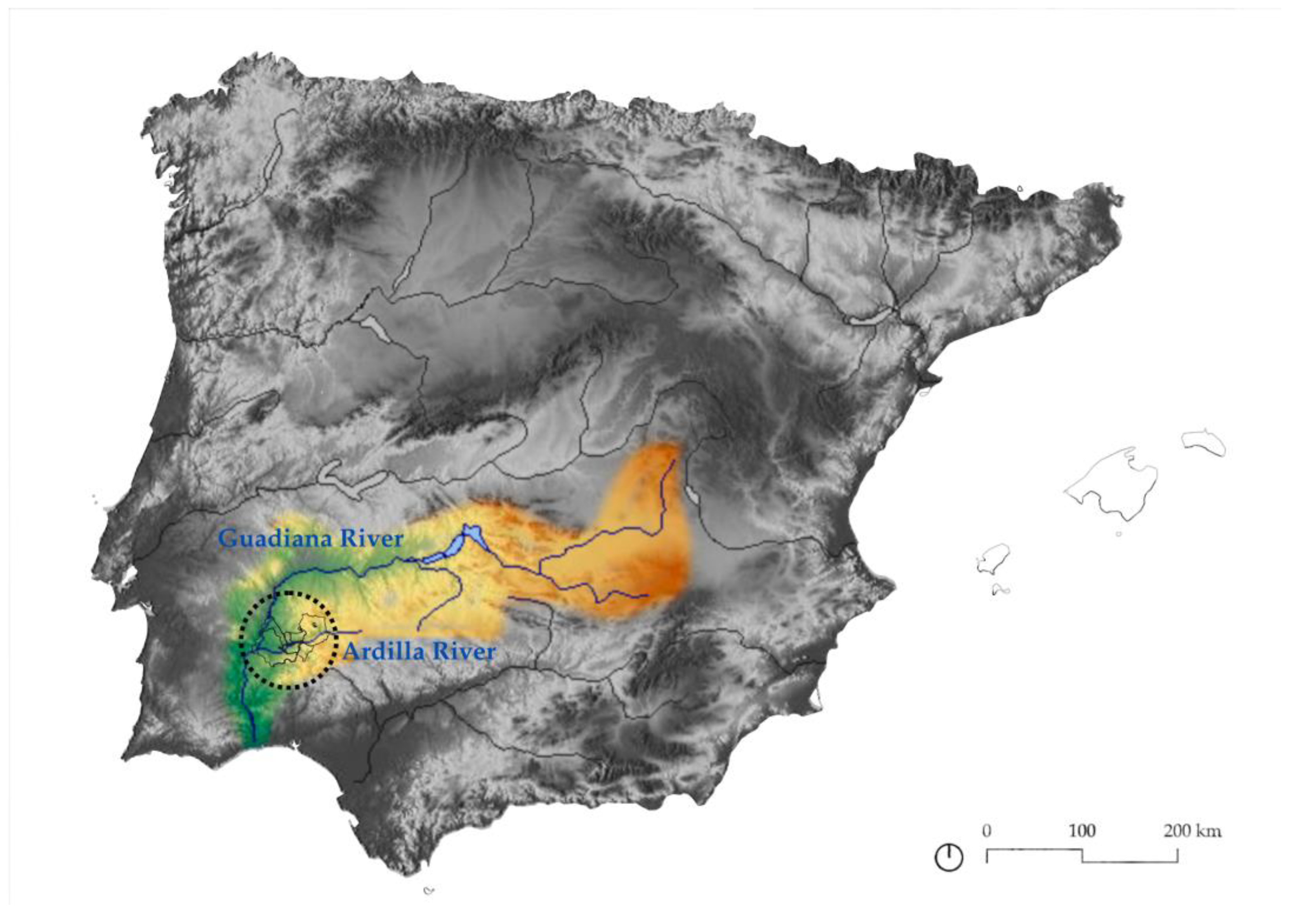
The case study area is shaped by a distinctive physical environment that plays a crucial role in defining its territorial identity and unity [19]. The mountainous reliefs that dominate the landscape form a natural barrier, limiting communication between the municipalities located on the border, despite the presence of a few transversal roads. This region also includes a penillanura [40], a gently sloping plain, bordered by the Sierra Morena mountain range to the north. The Guadiana River basin (Figure 6) is integral to this landscape, with the river and its tributaries shaping the valleys within the region. Over time, these geological processes have resulted in the formation of a nearly ideal flat area, the penillanura, which gradually slopes toward the northwest, eventually descending towards the Guadiana River. This landscape has played a key role in the evolution of the region and continues to influence both natural and human systems [41].
Hydrologically, the area is significant due to the presence of the Ardilla River and its tributaries, which provide essential water resources for the region. The river has a limited flow and is affected by seasonal droughts, making irrigation a challenge, particularly in the warmer months [40]. Despite the region’s location within the Guadiana hydrographic basin, which includes several reservoirs for irrigation and hydroelectric production, there are ongoing concerns about water supply, particularly during dry periods. The scarcity of water in the region has led to calls for the construction of additional reservoirs and the formation of local water associations to address these challenges. Although these efforts have not yet extended into the study area, water scarcity remains a pressing concern for the local population [42].
The climate of the area is Mediterranean, with a characteristic seasonal contrast and unpredictable cycles. The region experiences high levels of solar radiation, particularly in the non-winter months, which supports agricultural activity. However, the area’s limited rainfall and high evaporation rates contribute to periods of drought, which impact crop yields and exacerbate water scarcity. The climate’s variability presents challenges for maintaining consistent agricultural productivity and ensuring water availability for both consumption and irrigation [42].
In terms of vegetation, the region is primarily characterized by Mediterranean forests, interspersed with dehesas, or wooded grasslands. These landscapes have been significantly altered by human activity over the centuries, with the natural forests being cleared for agricultural purposes. The dominant vegetation types in the area include holm oak and cork oak, which are well adapted to the local climate. Agricultural practices, including olive cultivation and livestock farming, have further transformed the landscape, leading to changes in the local flora and fauna. The intensification of agriculture, particularly the expansion of pastureland, has reduced the diversity of wild mammals, with many species experiencing a decline due to the increased livestock population and the thinning of scrubland [3].
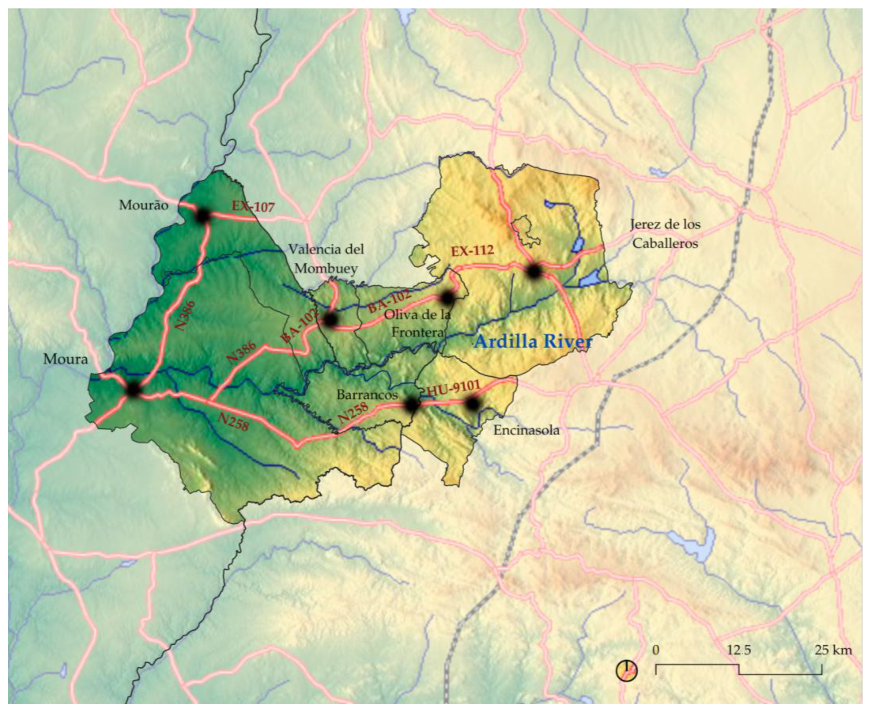
Another element that conditions the physical environment, but in this case is not natural, is the land communications system, which is recognized as being of great importance, since the land communications system is crucial for the region’s economic development and connectivity, particularly between Spain and Portugal. However, the road network faces challenges due to poorly designed secondary roads, which hinder internal connectivity. There are a few key roads, such as the BA-102/EX-112 or the N386, which links Oliva de la Frontera, Valencia del Mombuey with Amareleja—belonging to the municipality of Moura—and the HU-9101, which becomes the N258, linking Encinasola and Barrancos. In addition, there is the EX-107 road linking Villanueva del Fresno with Mourão, which is outside the scope of this work, but, it was thought, necessary to mention. The deficiencies are particularly evident on the Spanish side of the border, where the road network’s capacity and functionality are reduced, limiting the region’s potential for economic integration and cross-border cooperation [19].
In conclusion, the region’s physical environment (Figure 7), including its geography, hydrology, and climate, plays a pivotal role in shaping its agricultural and water management systems. While the Guadiana River and its tributaries provide essential water resources, the scarcity of water, combined with a Mediterranean climate and poor road infrastructure, poses significant challenges to the area’s development. The natural landscape, marked by the dehesas and Mediterranean forests, has been reshaped by centuries of human activity, particularly agriculture and livestock farming. To ensure long-term sustainability, it is essential to address the region’s water management challenges, improve its transport infrastructure, and enhance cross-border connectivity. A more efficient and integrated approach to water resources and infrastructure development is necessary to safeguard the region’s agricultural heritage and promote its economic revitalization.
Embedded within this physical landscape is a rich cultural heritage that is intrinsically tied to the region’s agricultural past. The mills located along the Ardilla River and its tributaries are a key feature of this heritage. These mills, which have served as central hubs for grain milling in the region, are an integral part of the area’s agricultural infrastructure. The mills are not only functional artifacts but also reflect the historical way of life and the technological adaptations that local populations employed to work with the land and its resources [2]. They embody the interplay between human ingenuity and natural resources, making them an essential part of the region’s cultural identity [43].

3.4. Production Framework

Dehesas, in general, are large areas of wooded pastureland, in which the degree of tree cover is variable, which have numerous uses and exploitation systems, of great socioeconomic, cultural, and environmental interest [44]. The physical environment in which the work area is located, which has just been analyzed, makes it difficult to intensify productive activities in these places. Therefore, livestock activity predominates alongside forestry and extensive agricultural exploitation [19]; however, this was not always the case.
After the Muslim domination, the settlers from the north of the peninsula began the process of pastureland deforestation, subjecting the territories to the origin of the current dehesas, and originating in the transfer by the Catholic Monarchs of grazing lands to military and religious orders and civilian communities. It is important to note that almost 40% of the pastureland in Spain is in Extremadura [44], of which the study area forms part. Until the 19th century, there were important extensions of communal lands, but since then, the territorial order has been altered by reducing them due to the disentailment processes and by the impact of mining, which modifies the structure of the city system. With this mining development, the livestock option was also reinforced in the region. In the second half of the 20th century, the agrarian model broke down, and pastures and Mediterranean forests were replaced to a large extent by timber reforestation—eucalyptus and conifers—changing the mountain landscape [45].
The development of agriculture, specifically, implies the radical substitution of the original vegetation cover, in addition to changing the cycles of matter and energy. By 1960, in many areas of the study regions, the active population was predominantly dedicated to the agricultural sector, and since then, the process of tertiarization has begun [45].
As for livestock, both in Roman times and in Al-Andalus, the primary activity of livestock is given, but not so much the agriculture that is reserved for the Guadalquivir Valley, and there are mostly pasture and forest districts. In the Christian era, livestock activity was characterized by the movement of livestock through a network of cattle trails between pastures and mountain areas. In the Modern Age, the transhumant livestock of the Mesta Real were confined to the Sierra Morena—intense in the working area—and other local enclaves. However, local livestock was more abundant, mainly sheep. In terms of land ownership and tenure regimes, the main models of farms in the Modern Age are configured. In the working area, there is a predominance of agricultural and livestock farms, with some estates, olive farms, mills, farmhouses, and wine presses. It is important to note that at this time, the main landowner of the lands in the working area was the Church. In pre-industrial times, there were some oil mills and many flour mills in the study area. This is because most of the manufacturing activity sectors are linked to the transformation of natural resources for local markets. The religious and civil disentailments of the 19th century also had an impact on the work zone. This was initially supposed to be a process of liberating the land market to boost agricultural productivity and redistribute land, but it functioned as a mechanism for financing the State. The disentailments favored the expansion of cultivated land to the detriment of forest and pastureland. Until the first third of the 20th century, industrial development was based on handicrafts for local consumption, linked to local natural resources such as mining and agro-industry. However, mining went into crisis, and the industrial base was centered on the agri-food sectors, but the post-war period and the first decades of Franco’s dictatorship would lead to a major industrial crisis [45].
As for energy production, until the first half of the 19th century, it was based on animal, human, and water power. With the beginning of the industrial revolution, the energy model changed due to the presence of coal and electrification from the second half of the 19th century. After the First World War, large hydroelectric power plants and electricity grids began to be installed in a large part of the territory. Specifically in the working area, the Sevillian network was developed between the two Communities, linking the power stations of Peñarroya-Pueblonuevo and Villanueva del Río y Minas. However, with the second technological revolution, based on petroleum, local energy sources are now in the background [45].
At present, the productive strategy of the dehesa, where the work area is located, are soils that generally do not have a large agricultural area and are therefore mainly oriented towards extensive livestock farming. However, agriculture and forestry and environmental uses are complementary, highlighting the multifunctional nature of the system. It is important to highlight, in this sense, that in addition to productive tasks, extensive livestock farming fulfills environmental responsibilities of great relevance, facilitating the spatial redistribution of the entire ecological system [35]. The performance of livestock represents production systems and landscapes as emblematic as dehesas or mountain pastures, which would not be feasible without the sustainable and logical management of extensive livestock. In this context, the territorial importance of the use of pastures by livestock exceeds its quantitative relevance compared to purely economic indicators; for this reason, integrated actions to promote this subsector acquire particular importance, given that they have a significant impact on various aspects that influence the territorial progress of rural areas in Andalusia—protection of nature and biodiversity, consolidation of the rural population, safeguarding of heritage values, etc.) [17].
In terms of agricultural uses, the Mediterranean climate and the poor soil mean that it is not possible to maintain sustainable and profitable agricultural crops on a large area of the pastures, so they resort to a rotational system in which they are not repeated on the same piece of land after a certain period of time. For this reason, the main forms of utilization for pastureland agricultural areas are cereals such as oats, barley, rye, and wheat. These crops contribute to the maintenance of the pastures, preventing them from being invaded by shrub species, while also feeding livestock or game. However, the current cereal surpluses lead to the abandonment of agricultural land, thus reducing the cultivated area and promoting the invasion by shrubs. Another frequent practice is the establishment of meadows. Other secondary uses of the dehesa are, among others, the hunting activity—of high economic profitability—the mycological sector, or the beekeeping sector [44].
As already mentioned, dehesa agriculture is related to the use of livestock, which is characterized by its extensive nature, supporting systems in which species capable of making efficient use of natural resources are used. This procedure has environmental advantages, but also helps to manage disadvantaged rural areas by increasing biological and landscape diversity, while maintaining decent socioeconomic conditions. Livestock can be considered as the main product of the dehesa, since it is a stabilization, perpetuation, and improvement tool. These are mostly of an extensive nature, dominated by autochthonous species, taking into account the limiting and ecological factors of the surrounding territory. These breeds allow an efficient use of natural resources, recognizing their importance in the management and sustainability of rural areas. This increases biological and landscape diversity and maintains sustainable production. The extensive production systems in place produce high quality products that are appreciated by consumers, but their low profitability makes it difficult to undertake technical improvements, and government aid is necessary for their maintenance [44].
In the working area, there are mainly cattle, sheep, and pigs, from which high-quality products are obtained, and the latter are fed by taking advantage of the production of acorns. Although cattle, sheep, and pigs are the three main livestock species in the dehesas, goats are important because they mainly provide meat and milk for cheeses. The species present in the working area are the Serrana and Retinta [44].
However, it is also important to highlight the role played by the dehesa as a tourist product, especially for its ornithology and natural assets, which provide economic complements to its own products, in which the equine livestock stands out; although it was once very important, nowadays, it is used as a leisure tool [44].
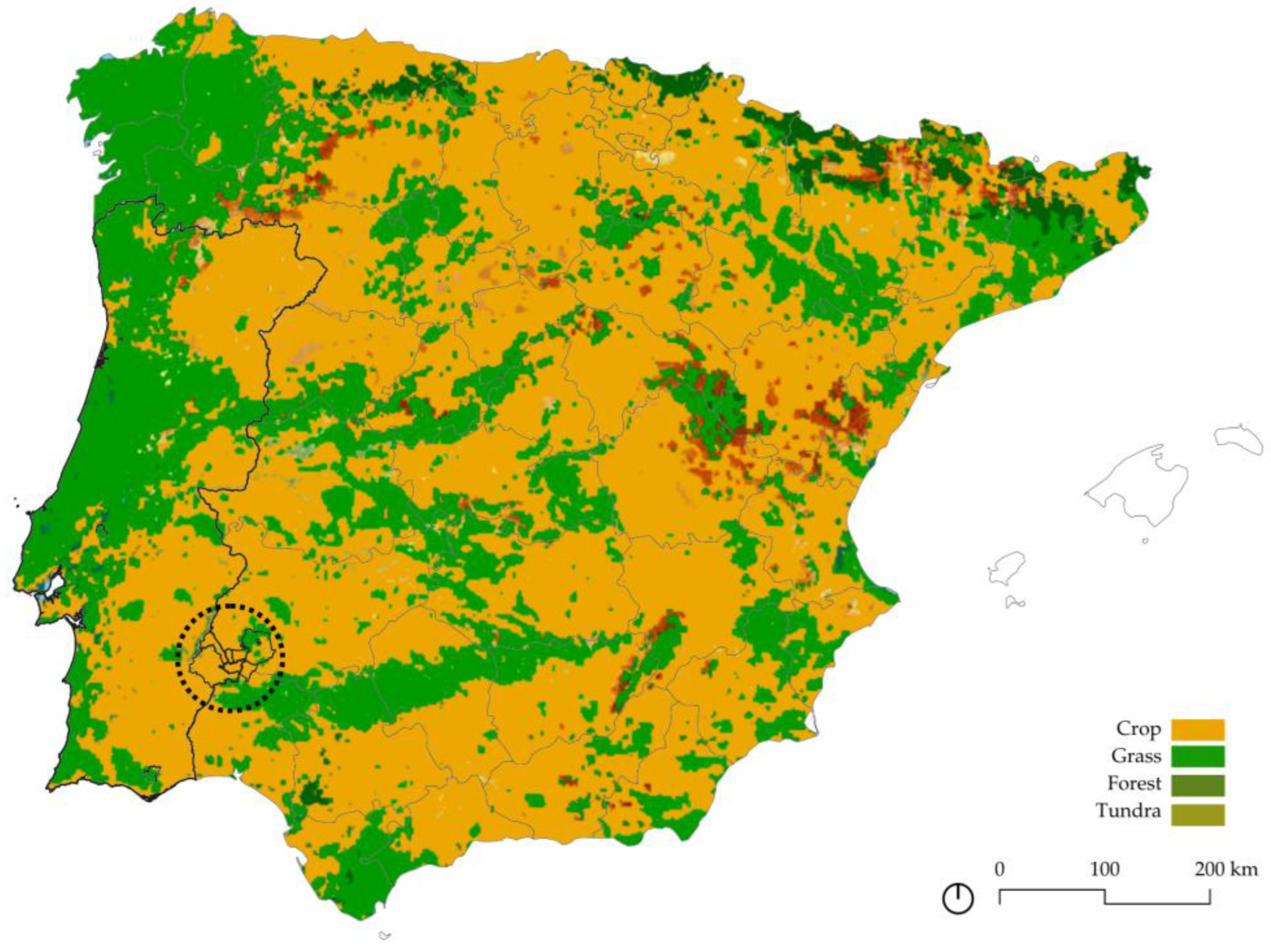
However, the situation in which the pasture systems find themselves (Figure 8), in general, are delicate, since they have low competitiveness, productivity, and profitability. However, with the incorporation of Spain into the European Union, and the application of the Common Agricultural Policy—which is the balance between agricultural production and the natural environment—it has undergone a series of reforms, largely to economically complement the situation of the sector.

3.5. Agricultural Heritage Framework

After reviewing the legal, physical, and productive framework, and observing the importance of the same in the area of work in particular, but in Spain and Portugal in general, throughout history, we will work with the heritage legacy in this rural area left by previous generations.
The rural heritage, composed of built elements and intangible manifestations [8], together with the territory interpreted in heritage terms, ensures that identity remains constant in the face of the standardizing pressures of globalization [4]. However, due to depopulation processes, a complicated process that includes, among other factors, low population density, the characteristics and values of these rural landscapes, protected by the society that inhabits them, are at risk of extinction [9]. To this must be added, as already mentioned, the added difficulty posed by the borders—both national and regional—when it comes to protecting assets that, despite being part of a common heritage system, are not protected jointly.
As previously mentioned, rural areas are home to a wide variety of heritage types, including both movable and immovable assets, as well as tangible and intangible elements. Within these, there are outstanding examples of immovable properties that represent important examples of productive heritage that allow us to identify historical processes of implantation that have influenced not only demographic and urban transformations, but also the formation of its heritage and landscape [17]. In this case, we will use the agricultural, industrial, or ethnological heritage found in the municipalities under study, since it is essential to recognize the agricultural value, as a general value, but the one that should support it is the cultural value, which understands the agricultural practice as a social asset and understand its contribution to the inhabitants.
Precisely, in order to recognize the importance of the productive legacy in the study area, reference has been made to the historical documents that existed at the time, in which specific sections were made to recognize these activities in those municipalities. Specifically, in the following table, we observe what is described of each of the municipalities in the geographic–statistical dictionaries of Madoz [21] and Miñano and Bedoya [22], in relation to production and/or industry (Table 3).
In general, there is a large production of grains, oil, and wine, as well as a variety of pomegranate trees. Specifically, for the concrete study of the patrimonial legacy, the work focuses specifically on the mills, which in the previous table are mentioned as existing in the 19th century, to observe if they are still preserved today (Table 4).
These are the structures that in their time served as mills, whose operation was based on facilitating, through a system that used a rotating wheel or a turbine, a mechanical process that served to grind cereals [43]. In this case, it is important, since they are goods that contributed to the economic development and cultural and social growth of particular times [18]. On the other hand, it would be important that the activity of this heritage does not cease, but in this case, the goods that are exhibited here today are not still in use, and therefore, the agricultural activity is relegated.
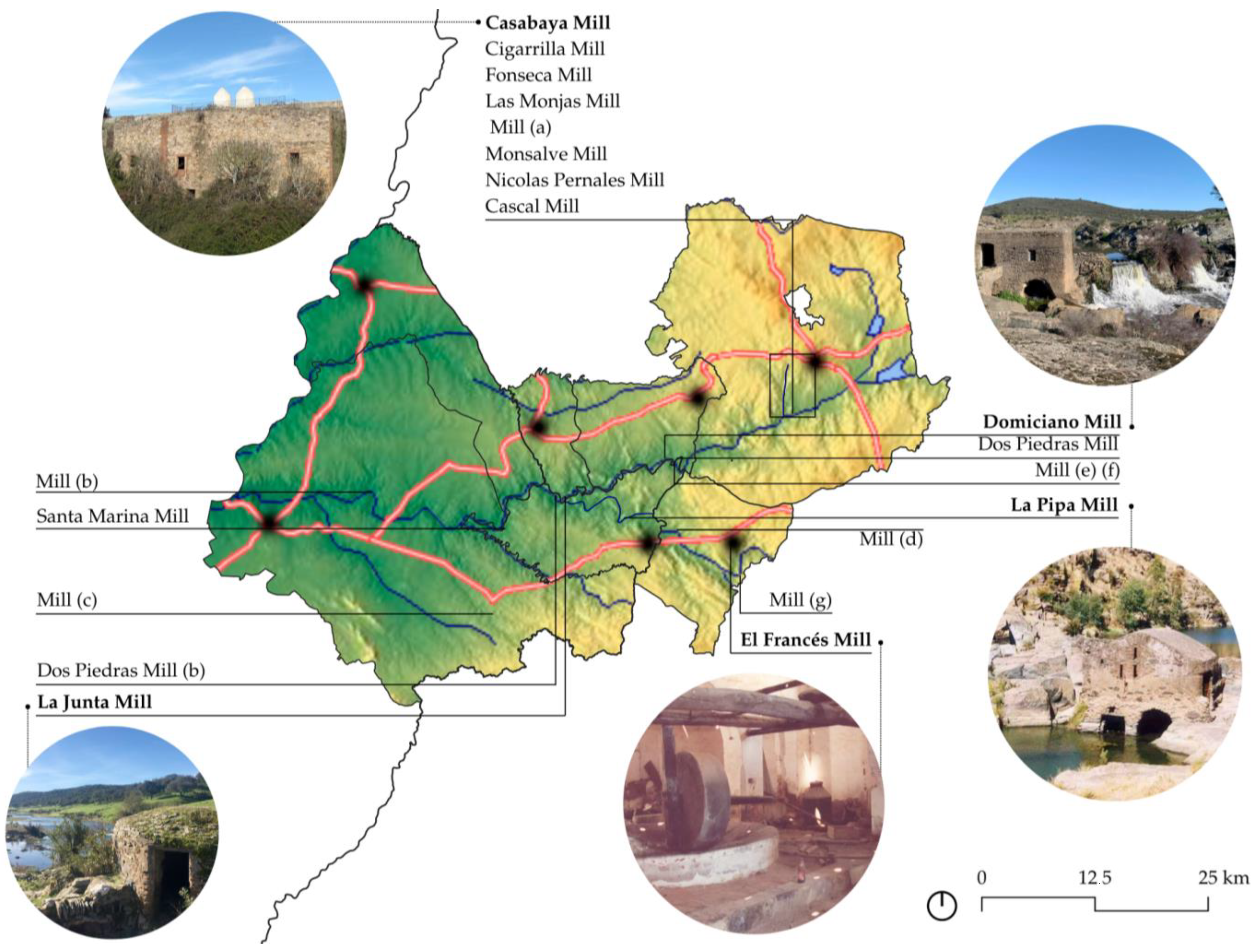
Once their location has been determined (Figure 9), it is necessary to understand them in strategic terms, as well as in the inherent characteristics of the region. It is crucial to consider heritage as a territorial resource to ensure its sustainability, as Unesco maintains [43]. Once the location in which the different pieces of mills are placed, it is observed that they accompany the course of the Ardilla River, from the Spanish side to the Portuguese side, and therefore, they are collected within the Guadiana Hydrographic Basin. In this sense, at present, there is no agreement that could unite all the municipalities involved in order to establish adequate protection for these pieces, which in no case are protected, nor properly identified.
Of the mills previously mentioned, information is available online for some, though not all, which represents a limitation of the study. For example, Mill La Junta owes its name to the confluence of the Ardilla and Murtigas rivers and is currently well preserved [46]. The El Francés Mill, dating back to the 18th century, functioned as an oil mill used for producing soap or oil, powered by beasts of burden. With the advent of new technologies, it fell into disuse [47]. A similar fate befell the Domiciano Mill, which remained operational until approximately 1960. This latter example consists of two adjoining naves, forming a double mill that is remarkably well preserved, including its original grinding stones [48]. These cases clearly demonstrate the presence of well-conserved examples of the area’s agricultural and productive legacy—heritage assets that deserve further study and protection.

4. Discussion

Therefore, while European heritage policy frameworks and academic discourse increasingly emphasize the importance of traditional mills as elements of rural and industrial heritage, the situation on the ground—particularly in cross-border territories such as the Guadiana River Basin—reveals a striking gap between theory and practice.
As outlined in the broader European context, mills are increasingly acknowledged as cultural assets that embody the historical relationship between people, land, and production systems. Instruments such as the Faro Convention [10] and the TICCIH Charter [12] advocate for the recognition of these structures within heritage landscapes, emphasizing their value as both tangible artifacts and repositories of local memory. However, in the case of the transboundary rural zone between Spain and Portugal, these values are not being translated into protective measures or territorial recognition.
Despite the growing emphasis on vernacular and rural industrial heritage, the windmills scattered across this Iberian border region often remain absent from national inventories, and in many cases, are not even locally identified. Unlike in the Netherlands or the UK—where projects like the Monumenten Inventarisatie Project (MIP) [16] or the SPAB Mills Section [15] ensure systematic documentation and restoration—Spain and Portugal’s approaches are fragmented and reactive, lacking binational coordination. The absence of integrated heritage strategies means these mills are rarely interpreted as part of a shared cross-border cultural landscape, even though their locations, typologies, and uses reveal clear historical continuities across both sides of the border.
Moreover, the lack of formal recognition has practical consequences. Without being listed in state databases such as Spain’s Guía Digital del Patrimonio Cultural or Portugal’s DGPC, these mills are excluded from conservation funding, protection statutes, and community-led revitalization initiatives. Researchers are thus forced to rely on non-official data sources—Google Maps, Wikiloc, and local knowledge—which, while valuable, underscore the absence of institutional stewardship.
This gap reflects the broader critique offered by scholars like Strangleman [14], who warns against a passive or nostalgic engagement with industrial ruins, and instead calls for active redefinition of heritage through community involvement and territorial meaning. In the case of the Spain–Portugal border region, such a redefinition is urgent: these mills are not isolated objects but integral to the identity and history of a fading rural fabric that spans both countries.
Therefore, what has been proposed here is to collect those assets that collect the values of traditional agrarian systems and that are within the definition of Agrarian Heritage of the Charter of Baeza, in order to make a proposal for its protection of territorial character, through some existing figure or some new proposals such as the Places of Agrarian Interest [2], but are not included in the heritage laws observed above. For this, and taking into account the study site where we are, it would be important that the land management instruments or management systems were of a territorial nature, at the supramunicipal and interadministrative level, for example, within the framework of the Guadiana Hydrographic Confederation, which could recognize the heritage associated with the main river and propose its protection.
To this end, The Guadiana River Basin itself offers a compelling case for applying the concept of Cultural Landscapes or Sites of Ethnological Interest to cross-border mill systems. The former is present in the current legislation of Andalusia and Extremadura, but not in the Portuguese legislation, which does not have a classification of protected assets. In the second case, as neither the Spanish nor the Portuguese legislation recognizes this figure, the European Landscape Convention [5] could be a tool to ensure the protection of the geological heritage of Extremadura and its maintenance. Yet, the current reliance on segmented national inventories obscures the broader landscape-based understanding that European conventions promote. This not only undermines heritage conservation but also weakens the potential for cultural tourism, sustainable development, and regional cooperation—objectives aligned with EU programs like Interreg and the European Heritage Label, which remain underutilized in this context.
In any case, the recognition of the agrarian heritage as a system would thus constitute a reference in territorial and urban planning and in the different processes of environmental evaluation of plans and projects. All the points identified should be considered in the studies of the physical environment and constitute an effective instrument for the preservation of the landscape in general.
In summary, while European policy and academic discourse provide a progressive vision for the protection of traditional mills, this vision is not yet realized in regions like the Iberian borderlands. Bridging this gap requires binational cooperation, community involvement, and a territorially integrated approach that moves beyond administrative boundaries and recognizes mills as part of a shared cultural continuum, as has been done in the present study.

5. Conclusions

The socioeconomic opportunities of the area are largely determined by progressive aging, whereby the more active and dynamic population invests its human capital in areas with greater connectivity and business activity. In contrast, the aging population often shows little interest and initiative, adopting a passive attitude towards public or private opportunities or initiatives. The socioeconomic decline of this place is encouraged by the skeptical attitude of the inhabitants towards the present dynamics of the rural environment. Therefore, it is essential to innovate in agriculture and livestock in order to be able to compete with other areas or forms of production. This is achieved through the balanced transformation of the dry cereal crops of the penillanura and the appropriate use of the forest areas to cultivate alternative crops that are valued in the market. These efforts must take place within a cross-border framework, as the land forms a continuous and uninterrupted landscape, as shown throughout this study.
The scarcity of water and investment—challenges present throughout the region—suggests that the majority of farms rely on rainfed crops. This, combined with poor soil quality, negatively affects the production competitiveness. Nevertheless, agricultural activity has historically maintained environmental balance, harmonizing productive use with the natural environment, and doing so with minimal disruption to the ecological system’s evolution. In this way, a balance has been struck between necessity and heritage—now increasingly at risk due to the ongoing reduction of the labor force in agriculture and livestock, as well as the irreversible loss of traditional land-use practices. These changes are causing shifts in soil use and altering the natural structure of the territory.
Although there is growing interest in protecting this type of heritage, there is currently no specific designation for agricultural heritage. While categories such as Place of Ethnological Interest or Cultural Landscape may be adapted, these apply only to the Spanish side. Moreover, any such protections would be granted individually, as there are no existing interregional agreements for protecting heritage as a system. As a result, their broader physical and cultural context is overlooked—despite its importance, as demonstrated in the study area.
This study has revealed the existence of a network of cross-border mills intrinsically linked to the Ardila River and its tributaries, which form part of the international Guadiana river basin. Their close connection to the landscape underscores the importance of recognizing and protecting these assets, as they represent a cultural legacy rooted in traditional practices that should be preserved over time. Nevertheless, researching the mills in this case has proven challenging, as many are not listed on official national or regional heritage registries. As a result, alternative sources—such as municipal websites and the trekking platform Wikiloc—had to be consulted, which imposes certain limitations on the study. Furthermore, while the mills have been identified, similar efforts should be extended to other elements of the area’s agricultural heritage in order to build a comprehensive network of productive assets capable of revitalizing local activity. Similar border situations can also be found elsewhere in Spain, along other sections of the border with Portugal, as well as in the north with France, where this study could similarly be applied.
In conclusion, it is important to highlight the nature of the area as a bordering place with the territories of other Autonomous Communities and, in its westernmost zone, with Portugal. This emphasizes the need to consider elements such as the administration of shared agrarian and ecological systems, the articulation of transport networks, the linking of local productive systems, or the presence of centers and areas of functional organization for the provision of services. These interconnected dynamics point to a structural framework for shaping the socioeconomic future of the region, grounded in its most valuable assets: environmental quality and traditional culture. Within this context, the protection and promotion of rural agricultural heritage emerge as fundamental pillars, with local communities playing a central role in safeguarding these practices and landscapes as part of a long-term, sustainable vision.

Author Contributions

Conceptualization, M.T.P.C. and A.M.A.; methodology, M.T.P.C. and A.M.A.; software, A.M.A.; validation, M.T.P.C.; formal analysis, M.T.P.C. and A.M.A.; investigation, M.T.P.C. and A.M.A.; resources, M.T.P.C. and A.M.A.; data curation, M.T.P.C. and A.M.A.; writing—original draft preparation, A.M.A.; writing—review and editing, M.T.P.C.; visualization, M.T.P.C., and A.M.A.; supervision, M.T.P.C.; project administration, M.T.P.C. and A.M.A. All authors have read and agreed to the published version of the manuscript.

Funding

This research received no external funding.

Institutional Review Board Statement

Not applicable.

Data Availability Statement

These data were derived from the following resources available in the public domain: National Geographical Institute https://www.ign.es/web/cbg-area-cartografia and Spanish National Institute of Statistics https://www.ine.es/, from Spain, and the Direcao-Geral do Território and the National Institute of Statistic from Portugal, together with the maps from https://maps-for-free.com/.

Acknowledgments

This study was supported with the predoctoral employment contract (PIF) Ainhoa Maruri has with the University of Seville, within the frame of the VIIth Own Research and Transfer Plan.

Conflicts of Interest

The authors declare no conflicts of interest.

References

  1. Pérez Cano, M.T.; Maruri Arana, A. Cultural Landscape and Heritage as an Opportunity for Territorial Resilience—The Case of the Border Between Castile and Leon and Cantabria. Land 2024, 13, 2233. [Google Scholar] [CrossRef]
  2. Castillo Ruiz, J. Carta de Baeza Sobre Patrimonio Agrario; Universidad Internacional de Andalucía: Seville, Spain, 2013. [Google Scholar]
  3. Lavado Contador, J.F. Introducción a la vegetación y la fauna de Extremadura. In Patrimonio Geológico de Extremadura; Muñoz Barco, P., Martínez Flores, E., Eds.; Junta de Extremadura: Mérida, Mexico, 2010; pp. 53–86. [Google Scholar]
  4. Martín Jiménez, M.I. Patrimonio y paisaje en España y Portugal. Del valor singular a la integración territorial. Boletín Asoc. Geógrafos Españoles 2016, 71, 347–374. [Google Scholar] [CrossRef]
  5. Council of Europe. European landscape convention. In Report and Convention; Council of Europe: Strasbourg, France, 2000. [Google Scholar]
  6. Melón Jiménez, M.A. Las fronteras de España en el siglo XVIII. Algunas consideraciones. Obradoiro Hist. Moderna 2010, 19, 161–186. [Google Scholar] [CrossRef]
  7. ICOMOS. Principles on Rural Landscapes as Heritage. In Proceedings of the 19th ICOMOS General Assembly, Delhi, India, 11–15 December 2017. [Google Scholar]
  8. Fernández Salinas, V.; Romero Moragas, C. El Patrimonio Local y el Proceso Globalizador. Amenazas y Oportunidades. Tendencias Futuras en la Gestión Local del Patrimonio; Asociación Para el Desarrollo Rural de Andalucía: Granada, Spain, 2008; pp. 17–29. [Google Scholar]
  9. Castillo Ruiz, J. El patrimonio cultural podría estar en peligro y los responsables son la memoria, la salvaguardia, la comunidad y el paisaje cultural (además del turismo, claro). Erph Rev. Electrónica Patrimonio Histórico 2021, 28, 3–38. [Google Scholar] [CrossRef]
  10. Council of Europe. Framework Convention on the Value of Cultural Heritage for Society (Faro Convention); Council of Europe: Strasbourg, France, 2005; Available online: https://www.coe.int/en/web/culture-and-heritage/faro-convention (accessed on 20 March 2025).
  11. ICOMOS–TICCIH. Principles for the Preservation of Industrial Heritage Sites, Structures, Areas and Landscapes (The TICCIH Charter). 2003. Available online: https://ticcih.org/about/about-ticcih/dublin-principles/ (accessed on 23 March 2025).
  12. ICOMOS. The Burra Charter: The Australia ICOMOS Charter for Places of Cultural Significance. 1999. Available online: https://australia.icomos.org/publications/burra-charter-practice-notes/ (accessed on 20 March 2025).
  13. Biel, A.; Bergström, G.; Henriksson, M. Cultural Heritage and the Challenge of Sustainability; Swedish National Heritage: Stockholm, Sweden, 2010. [Google Scholar]
  14. Strangleman, T. “Smokestack nostalgia”, “ruin porn” or working-class obituary: The role and meaning of deindustrial representation. Int. Labor Work. Cl. Hist. 2013, 84, 23–37. [Google Scholar] [CrossRef]
  15. SPAB (Society for the Protection of Ancient Buildings). SPAB Mills Section. Available online: https://www.spab.org.uk/mills (accessed on 22 April 2025).
  16. Rijksdienst Voor Het Cultureel Erfgoed. Monumenten Inventarisatie Project (MIP). Available online: https://cultureelerfgoed.nl/onderwerpen/monumenten-inventarisatie-project-mip (accessed on 22 April 2025).
  17. del Espino Hidalgo, B.; Rodríguez Díaz, V.; González-Campos-baeza, Y.; Santana Falcón, I. Accessibility Indicators for the Assessment of Cultural Heritage as a Resource for Development in Rural Areas of Huelva. Archit. City Environ. 2022, 50, 1–30. [Google Scholar] [CrossRef]
  18. Ruiz, M.A.C. Notas sobre la ganadería de la Sierra de Huelva en el s. XV. Historia. Instituciones. Doc. 1994, 21, 63–82. [Google Scholar] [CrossRef]
  19. Romero Valiente, J.M. La frontera interautonómica de Andalucía: Un espacio periférico, deprimido y desarticulado. Rev. Estud. Andal. 1990, 15, 1–28. [Google Scholar] [CrossRef]
  20. Romero Valiente, J.M. El borde septentrional onubense: Un espacio “a caballo” entre Andalucía y Extremadura. Huelva Hist. 1992, 4, 249–260. [Google Scholar]
  21. Madoz, P. Diccionario Geográfico-Estadístico-Histórico de España y sus Posesiones de Ultramar; Establecimiento Tipográfico de P. Madoz y L. Sagasti: Madrid, Spain, 1845–1850. [Google Scholar]
  22. Miñano y Bedoya, B. Diccionario Geográfico-Estadístico de España y Portugal; Imprenta de Pierart-Peralta: Madrid, Spain, 1826–1828. [Google Scholar]
  23. García, E.C.; Valverde, F.A.N.; Martos, J.C.M. Cohesión territorial y subsidio de desempleo agrario. El caso de Andalucía. In Revalorizando el Espacio Rural: Leer el Pasado Para Ganar el Futuro: XVII Coloquio de Geografía Rural, Colorural 2014, Girona, 3–6 September 2014; Documenta Universitaria: Girona, Spain, 2014; p. 183. [Google Scholar]
  24. Ministerio de Agricultura, Pesca y Alimentación. Diagnóstico de la Igualdad de Género en el Medio Rural; Ministerio de Agricultura, Pesca y Alimentación: Madrid, Spain, 2021. [Google Scholar]
  25. EPSON. Cross-Border Cooperation—Cross-Thematic Study of INTERREG and ESPON Activities; EPSON: Luxembourg, 2007. [Google Scholar]
  26. Medina, M.G.; Fedeli, V. Exploring European urban policy: Towards an EU-national urban agenda? Gestión Análisis Políticas Públicas 2015, 14, 7–22. [Google Scholar]
  27. Treaty of Tordesillas, Signed in Tordesillas, Spain, on 7 June 1494. Available online: https://ehne.fr/en/encyclopedia/themes/international-relations/europe-and-legal-regulation-international-relations/treaty-tordesillas-june-7-1494 (accessed on 20 March 2025).
  28. Rengifo Gallego, J.I.; Sánchez Martín, J.M. El patrimonio en Extremadura: Un mecanismo para la cooperación transfronteriza = The heritage in Estremadura: A tool for the cross border cooperation. Polígonos. Rev. Geografía 2017, 29, 223–248. [Google Scholar] [CrossRef]
  29. BOE. No. 43, February 18, 2010. Official State Bulletin of Spain.
  30. DECREE 347/2004; Establishing the Organic Structure of the Ministry of the Presidency. 2004.
  31. BOE. No. 166, of July 9, 2010. Official State Bulletin of Spain.
  32. BOE-A-1978-31229; Spanish Constitution. Madrid, Spain. 1978.
  33. Royal Decree 35/2023; Approving the Revision of the Hydrological Plans of the Western Cantabrian, Guadalquivir, Ceuta, Melilla, Segura and Júcar River Basins, and of the Spanish Part of the Eastern Cantabrian, Miño-Sil, Duero, Tajo, Guadiana and Ebro River Basins. 2023.
  34. Law 107/2001; On the Bases of the Policy and Rules for the Protection and Valorization of Cultural Heritage. Unesco, 2001.
  35. Organic Law 1/2011; Reforming the Statute of Autonomy of the Autonomous Community of Extremadura. Official Diary of Extremadura, 2011.
  36. Law 2/1999; On the Historical and Cultural Heritage of Extremadura. Official Diary of Extremadura, 1999.
  37. Law 8/1998; On the Conservation of Nature and Natural Spaces of Extremadura. Official Diary of Extremadura, 1998.
  38. Law 14/2007; Of 26 November, on the Historical Heritage of Andalusia. Official Bulletin of the Andalusian Board, 2007.
  39. Law 1/1991; On the Historical Heritage of Andalusia. Official Bulletin of the Andalusian Board, 1991.
  40. Garzón Heydt, G. Geomorfología y paisaje extremeño. In Patrimonio Geológico de Extremadura; Muñoz Barco, P., Martínez Flores, E., Eds.; Junta de Extremadura: Mérida, Mexico, 2010; pp. 70–95. [Google Scholar]
  41. Gómez Amelia, D. Rasgos geomorfológicos de Extremadura. In Aportaciones a la Geografía Física de Extremadura con Especial Referencia a las Dehesas; Schnabel, S., Lavado Contador, F., Gómez Gutierrez, A., García Marín, R., Eds.; Asociación Profesional para la Ordenación del Territorio, el Ambiente y el Desarrollo Sostenible—Fundicotex: Cáceres, Spain, 2010; pp. 9–24. [Google Scholar]
  42. García Marín, R.; Mateos Rodríguez, A.B. El clima de Extremadura. In Aportaciones a la Geografía Física de Extremadura con Especial Referencia a las Dehesas; Schnabel, S., Lavado Contador, F., Gómez Gutierrez, A., García Marín, R., Eds.; Asociación Profesional para la Ordenación del Territorio, el Ambiente y el Desarrollo Sostenible—Fundicotex: Cáceres, Spain, 2010; pp. 25–52. [Google Scholar]
  43. Trujillo Guilcapi, J.D. Puesta en Valor del Patrimonio Edificado, Caso de Estudio los Molinos de Agua en el Cantón Guano. Bachelor’s Thesis, Universidad Nacional de Chimborazo, Riobamba, Ecuador, 2024. [Google Scholar]
  44. Jariego García, A.; Lavado Contador, J.F. Usos del suelo y ganadería en las dehesas de Extremadura. In Patrimonio Geológico de Extremadura; Muñoz Barco, P., Martínez Flores, E., Eds.; Junta de Extremadura: Mérida, Mexico, 2010; pp. 125–154. [Google Scholar]
  45. Díaz Quidiello, J. Atlas de la Historia del Territorio de Andalucía; Institute of Statistics and Cartography of Andalusia: Sevilla, Spain, 2009. [Google Scholar]
  46. Ruta de los Molinos del Ardila. Available online: https://turismo.valenciadelmombuey.com/listado/valencia-del-mombuey/rutas/ruta-de-los-molinos-del-ardila/ (accessed on 22 April 2025).
  47. El Molino del Francés de Encinasola. Available online: https://www.huelvainformacion.es/provincia/Molino-Frances-Encinasola_0_1517548613.html (accessed on 22 April 2025).
  48. Oliva de la Frontera: Ruta Circular Molino de Domiciano. Available online: https://es.wikiloc.com/rutas-senderismo/oliva-de-la-frontera-ruta-circular-molino-de-domiciano-10387701 (accessed on 22 April 2025).
Figure 1. Map of the current Autonomous Communities, Regions and Districts, and the Provinces’ limits on which the study centers, on both sides of the border between Spain and Portugal. Source: own elaboration based on both National Geographical Institutes’ cartographies.
Agriculture 15 00956 g001
Figure 2. Map of municipalities on which the study is centered. Source: own elaboration based on both National Geographical Institutes’ cartographies.
Agriculture 15 00956 g002
Figure 3. Diagram of the methodology used in the study. Source: own elaboration.
Agriculture 15 00956 g003
Figure 4. Map population and population density of the chosen municipalities. Source: own elaboration based on the information of the Spanish and Portuguese National Statistics Institutes and both National Geographical Institutes’ cartographies.
Agriculture 15 00956 g004
Figure 5. Map of the Euroregions and macroregions in the Iberian Peninsula. Source: https://www.sociedadiberista.org/eurorregiones-y-macrorregiones-en-la-peninsula-iberica/ (accessed on 17 March 2025).
Agriculture 15 00956 g005
Figure 6. Map of Guadiana river basin in Spain and Portugal over the topographical base—greener colors mean a lower height, weather warmer colors imply a higher height. Source: own elaboration over the base of the map from https://maps-for-free.com/ (accessed on 30 March 2025).
Agriculture 15 00956 g006
Figure 7. Map of the physical framework of the working area in which the base is the relief of the territory—from lower areas in green to red colors for the upper ones—and over it appear the hydrography (blue), the road network (red), and the cities of study (black dots). Source: own elaboration over the base of the map from https://maps-for-free.com/ (accessed on 30 March 2025).
Agriculture 15 00956 g007
Figure 8. Map of the land use in the Iberian Peninsula, underlying the working area. Source: own elaboration over the base of the map from https://maps-for-free.com/ (accessed on 28 March 2025).
Agriculture 15 00956 g008
Figure 9. Map of mills in the study area over the base of the physical framework map, with pictures of some of the best examples of the mills. Source: own elaboration with the base from https://maps-for-free.com/ (accessed on 30 March 2025) the data of the Guia Digital of the Andalusian Institute of Historical Heritage, the website of the Cultural Heritage of Portugal, Google Maps, the websites of the villages, and Wikiloc.
Agriculture 15 00956 g009
Table 1. Table related to Figure 4, where the basic data of the municipalities are explained. Source: own elaboration based on the data of both the Spanish and Portuguese National Statistics Institutes.
MunicipalityCountryRegionProvince/
District
Surface
(km2)
Population
(inh.)
Population Density (inh./km2)
EncinasolaSpainAndalucíaHuelva178.1212947.49
Jerez de los CaballerosSpainExtremaduraBadajoz739.8914712.36
Oliva de la FronteraSpainExtremaduraBadajoz149.3493635.2
Valencia del MombueySpainExtremaduraBadajoz757139.96
MouraPortugalAlentejoÉvora957.7313,25913.84
BarrancosPortugalAlentejoBeja168.43169710.07
MourãoPortugalAlentejoBeja278.5423518.44
TOTAL Spain 402.42694317.25
TOTAL Portugal 1404.717,30712.3
TOTAL Work Zone 1807.1224,25013.41
inh./km2 = inhabitants per square kilometer.
Table 2. Table of the protection figures of heritage on both sides of the frontier. Source: own elaboration based on the data of the Heritage Laws of Portugal, Extremadura, and Andalusia.
PortugalSpain
ExtremaduraAndalusia
LawLaw 107/2001, of 8 September 2001, on the Bases of the Policy and Rules for the Protection and Valorization of Cultural Heritage.Law 2/1999, of 29 March 1999, on the Historical and Cultural Heritage of Extremadura. Law 1/1991, of 3 July 1991, on the Historical Heritage of Andalusia.
FiguresNational Monument (MN: national monument)
Property of public interest (IIP: Property of public interest, MIP: Monument of public interest, CIP: Complex of public interest, SIP: Site of public interest).
Property of municipal interest (IM: Property of municipal interest, MIM: Monument of municipal interest, CIM: Complex of municipal interest, SIM: Site of municipal interest).
Historic Sites, Archaeological Protection Areas, Historic Gardens, Sites of Ethnological Interest, Monuments, Archaeological Park, Historic Site, Archaeological Zones, and Paleontological Zones.Historic Site, Historic Gardens, Site of Ethnological Interest, Site of Industrial Interest, Monuments, Historic Site, Archaeological Areas, and Heritage Areas.
Table 3. Table of the production and industry of the nineteenth century in each village. Source: own elaboration based on the data of Diccionario geográfico-estadístico-histórico de España y sus posesiones de ultramar, by Pascual Madoz [21] and the Diccionario geográfico-estadístico de España y Portugal, by Sebastián Miñano y Bedoya [22].
MunicipalityProductionIndustrial
Encinasolawheat, barley and oats; the imported products are wine, oil and vegetables; there are sheep, goats, pigs and cattle, half of which are used for farming and hunting rabbits, partridges, hares, wild boars, and deer.The general activity is agriculture; muleteering and women weaving linen and cloth for domestic use.
Jerez de los CaballerosWheat, barley, rye, oats, vegetables, fruits, wine, oil and acorns; sows, cattle, sheep, goats, working and pack horses, beehives, big and small game, abundant fish and tench fishing.There are 7 leather tanning factories; 3 of wax and tallow candles; 8 of soft soap; 4 of pottery; 20 looms of canvas, tow and wool blankets; 9 oil mills; 2 presses; 40 flour mills, several tile and brick ovens, 13 stores, fair in the first 8 days of September, of esparto grass and cattle.
Oliva de la Fronterawheat, barley, oats, chickpeas, beans, oil, oranges, fruits (melons and watermelons); sows, cattle, goats, sheep and horses; game of all kinds and fish from the river.linen and wool looms, run by women;
20 flour mills; wheat is imported, and a modern concession fair is held on September 16 (sows and cattle).
Valencia del Mombueywheat, rye, barley, oats, chickpeas, beans, wine and acorns; sows, cattle, sheep and mares, and game of all kinds.4 brandy factories, homemade linen looms, 4 flour mills, 4 bakeries, and the pig trade.
MouraIt abounds in grains, cattle, some wine, and a lot of oil. They have olive groves on the east and south and the rest is occupied by large oak and cork oak forests where they raise a lot of sow cattle; many beehives, abundant hunting.-
Barrancos--
MourãoIt produces many grains, oil, wine, cattle, beehives; hunting and fishing of the Guadiana River.-
Table 4. Table of the mills in each village related to Figure 9. Source: own elaboration based on the data of the Guia Digital of the Andalusian Institute of Historical Heritage, the website of the Cultural Heritage of Portugal, Google Maps, the websites of the villages, and Wikiloc.
Municipality
EncinasolaFrench Mill
Mill (d)
Mill (g)
Jerez de los CaballerosCasabaya Mill
Cigarrilla Mill
Fonseca Mill
Las Monjas Mill
Mill (a)
Monsalve Mill
Nicolas Pernales Mill
Cascal Mill
Oliva de la FronteraDomitian Mill
Mill (e)
Mill (f)
Dos Piedras Mill (a)
Valencia del MombueyLa Junta Mill
Dos Piedras Mill (b)
MouraSanta Marina Mill
Mill (b)
Mill (c)
BarrancosLa Pipa Mill
Mourão-
Disclaimer/Publisher’s Note: The statements, opinions and data contained in all publications are solely those of the individual author(s) and contributor(s) and not of MDPI and/or the editor(s). MDPI and/or the editor(s) disclaim responsibility for any injury to people or property resulting from any ideas, methods, instructions or products referred to in the content.