Mapping Paddy Rice Using Weakly Supervised Long Short-Term Memory Network with Time Series Sentinel Optical and SAR Images


Abstract
1. Introduction
2. Materials and Methods
2.1. Study Area and Materials
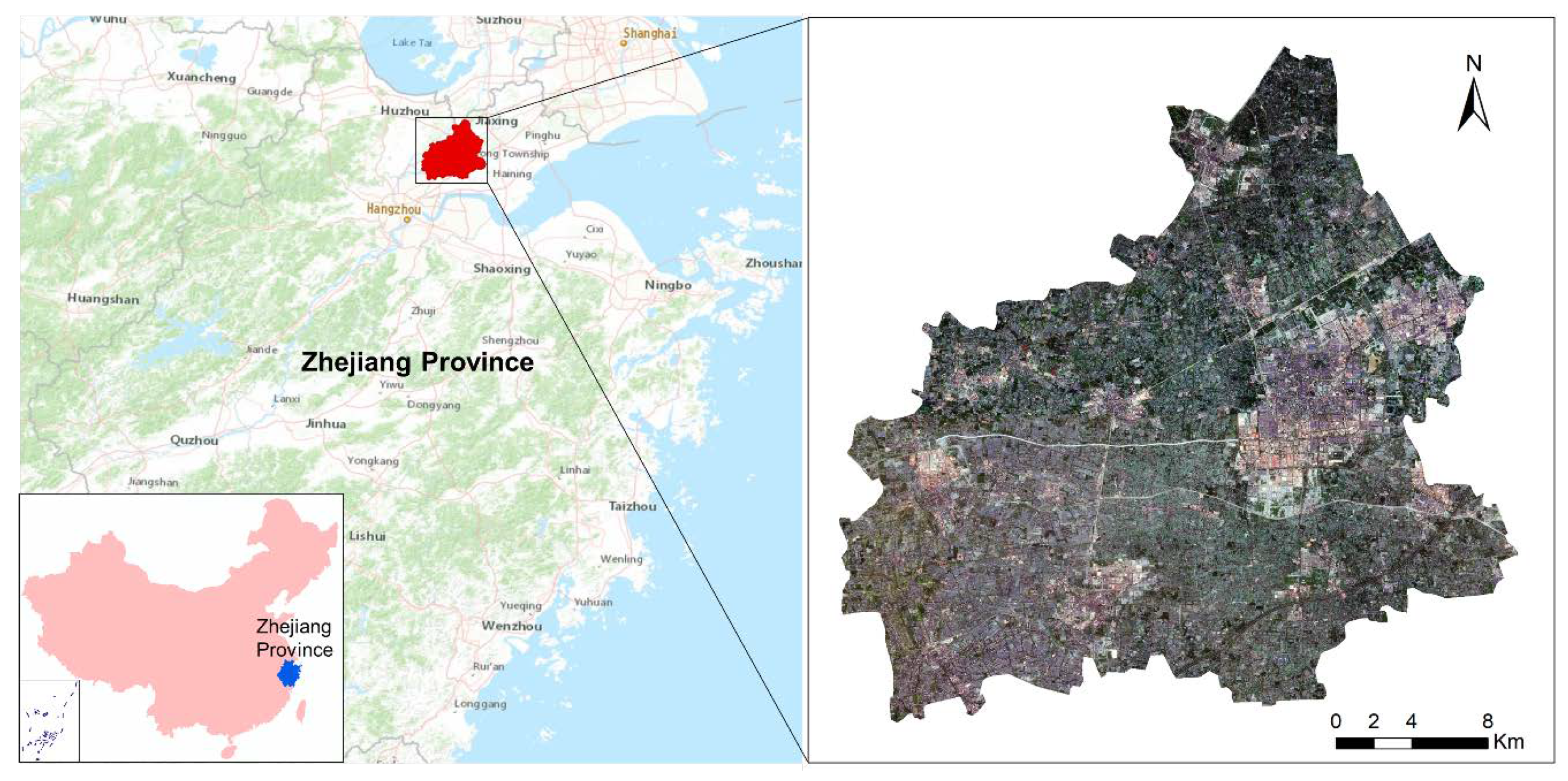
2.1.1. Study Area
2.1.2. Datasets and Preprocessing
Time Series SAR Data
Sentinel-2 Time Series Images
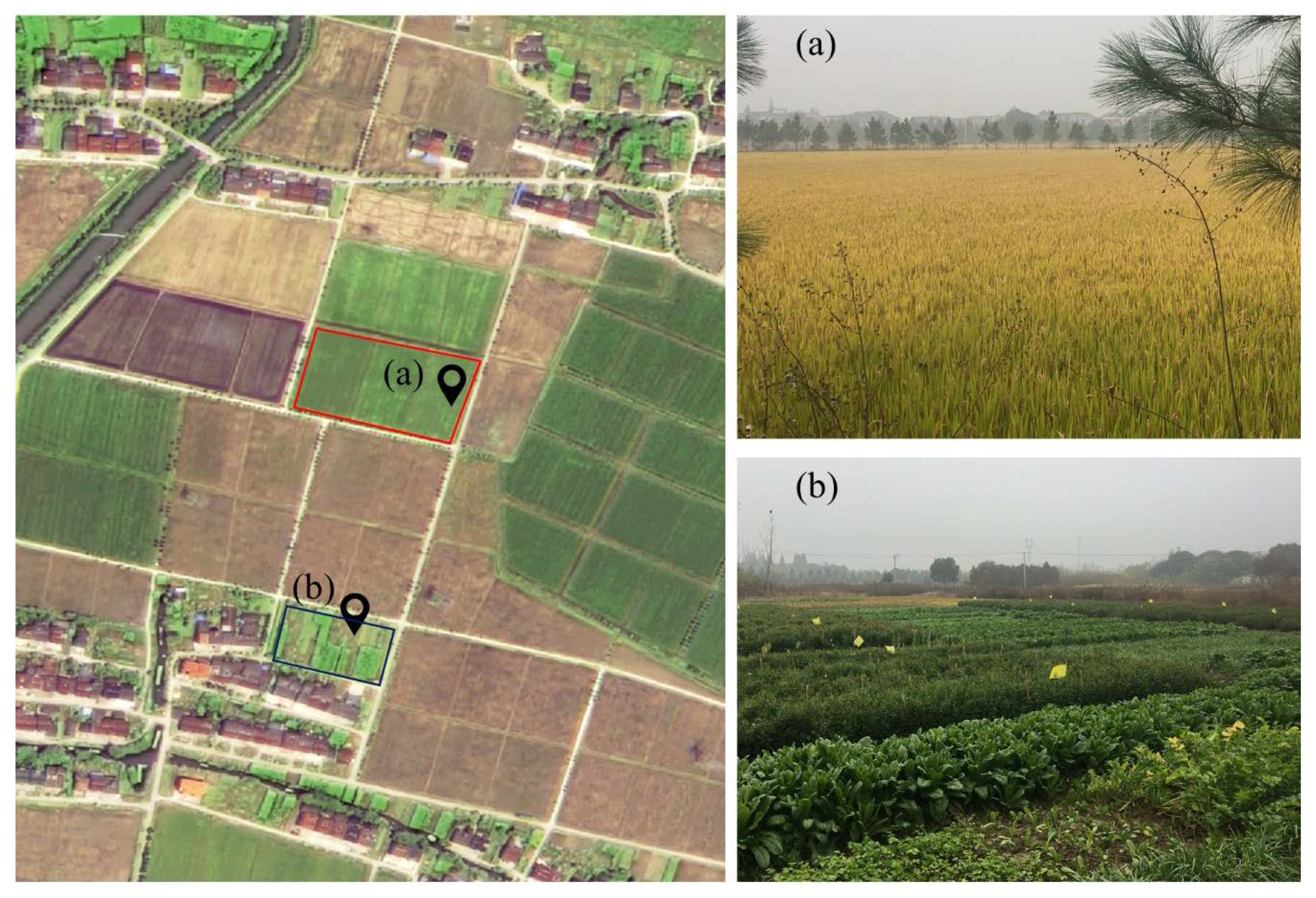
Field Sampling Data
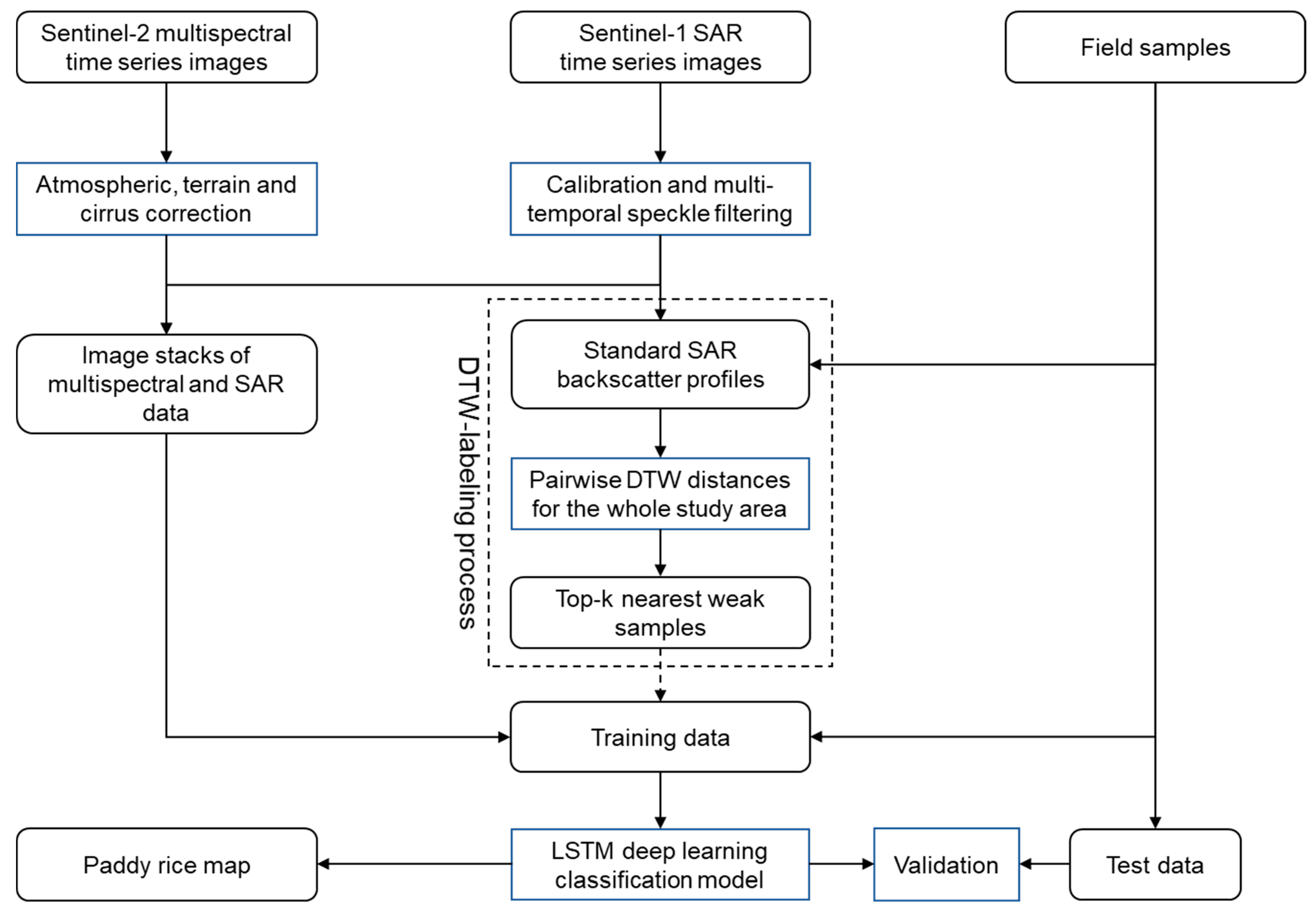
2.2. Methodology
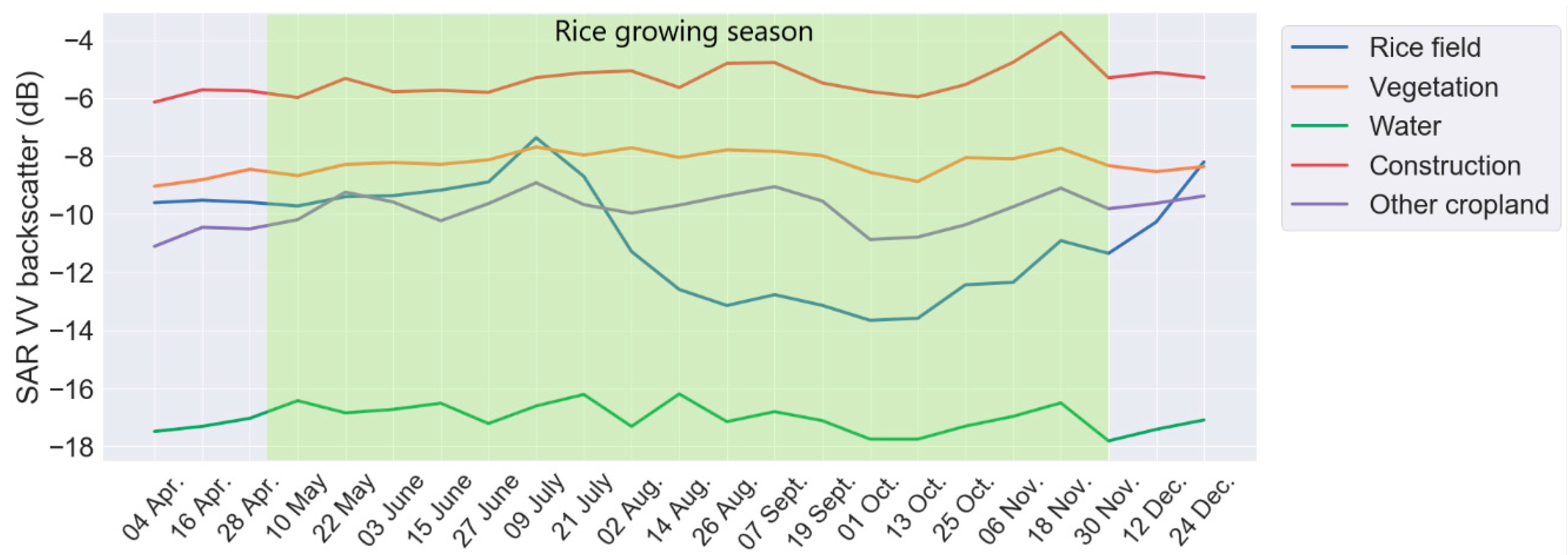
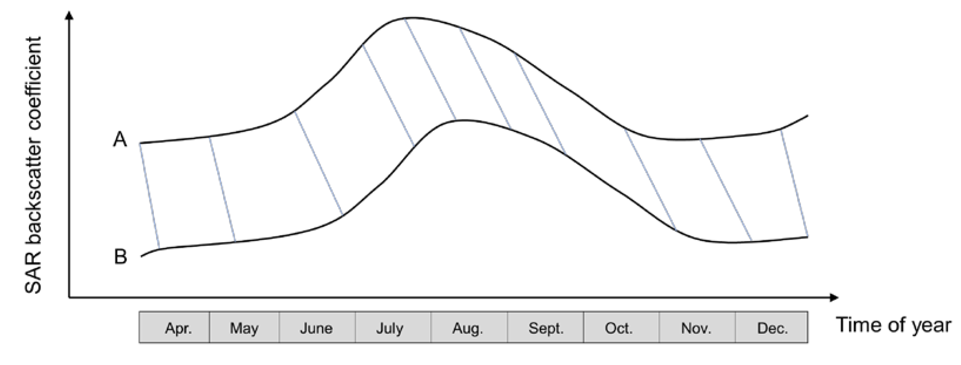
2.2.1. Standard Time Series SAR Backscatter Profiles
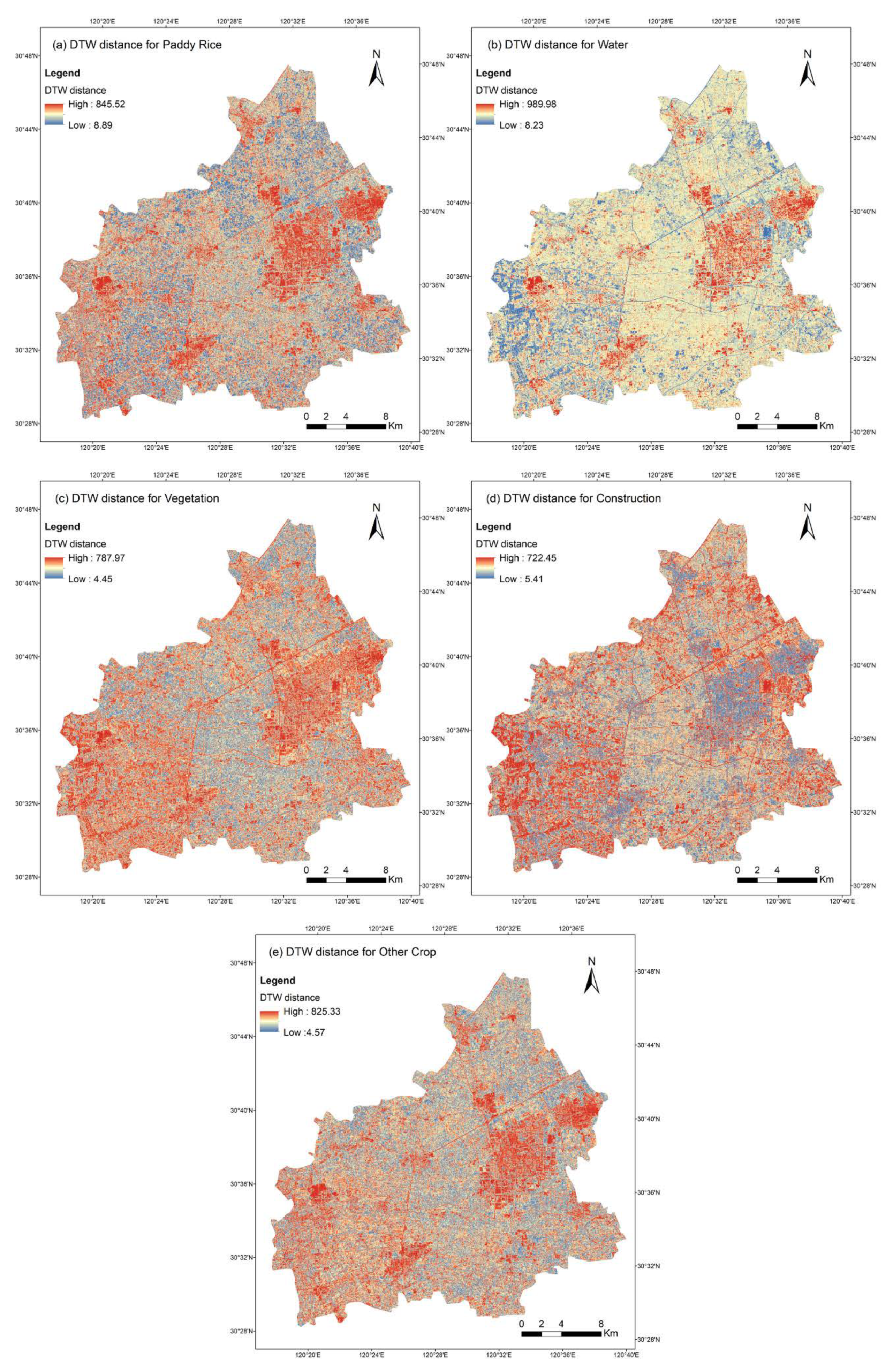
2.2.2. DTW Distance-Based Sampling
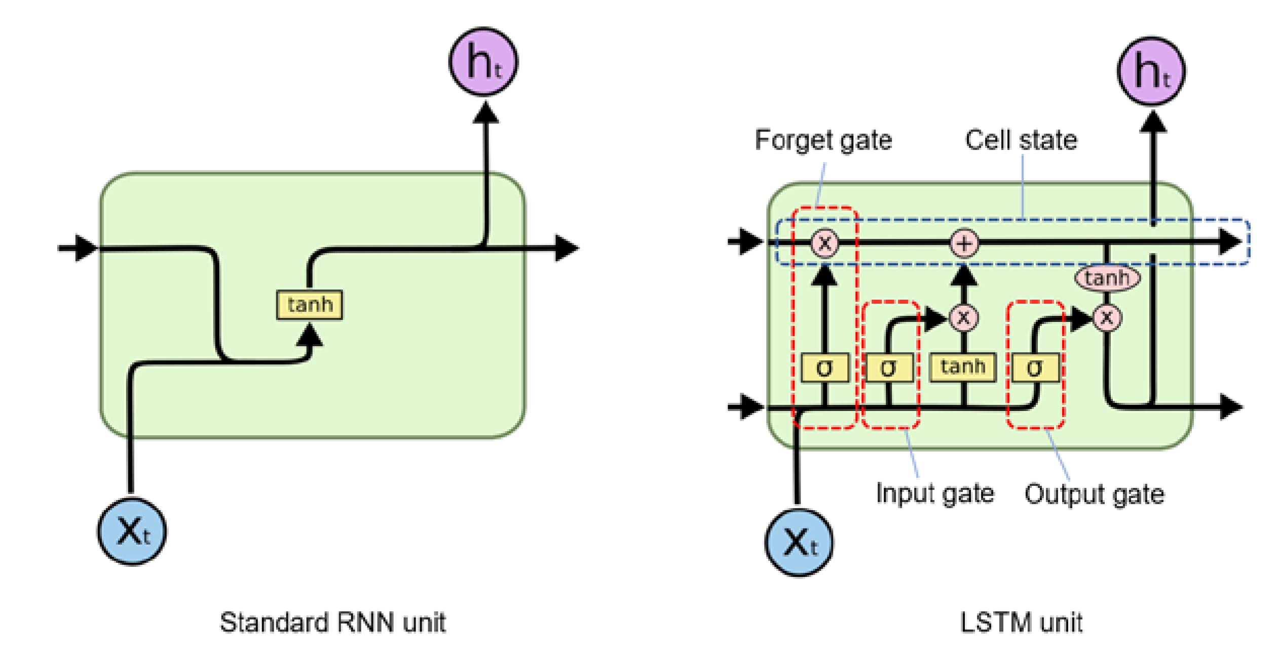
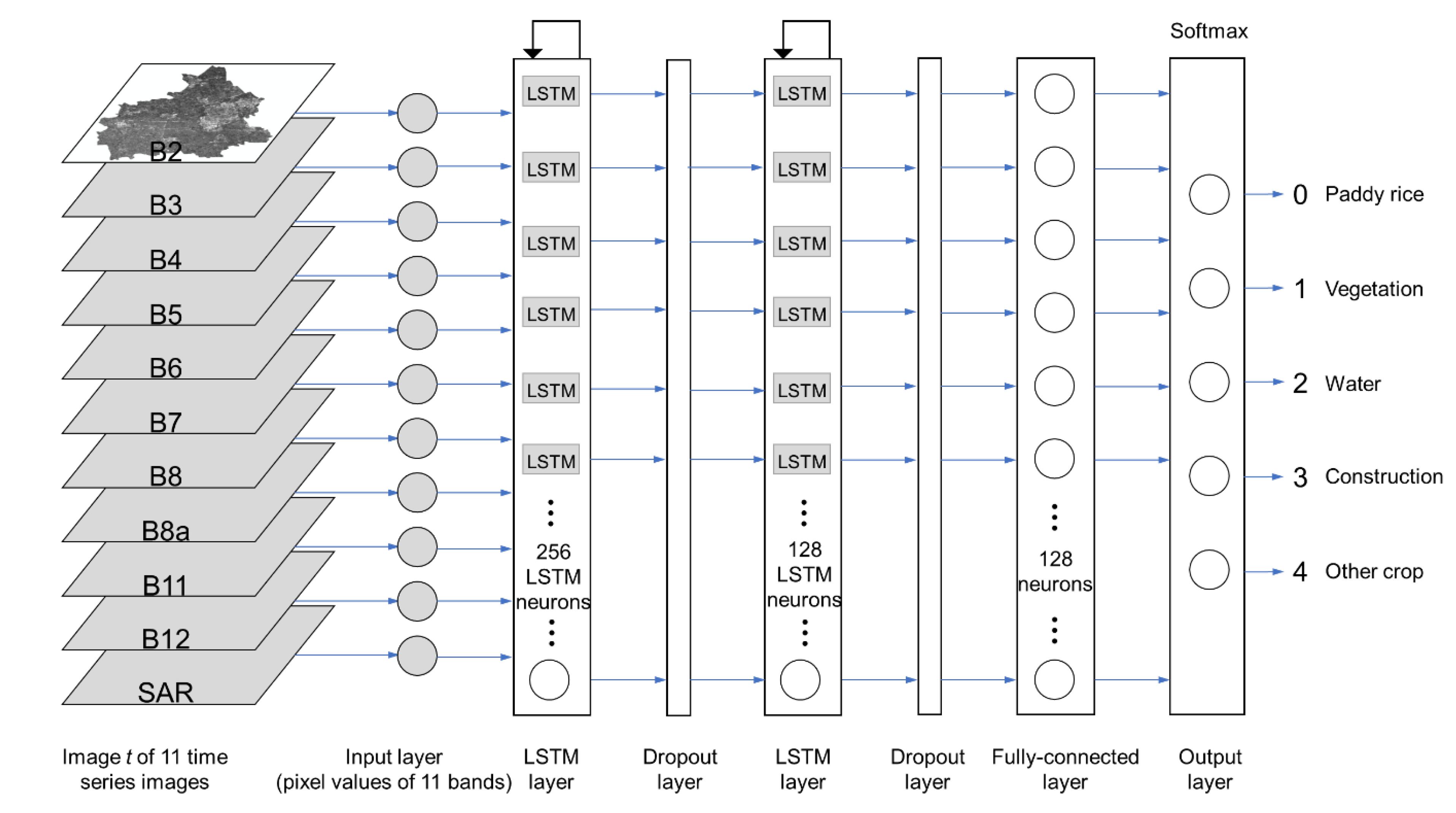
2.2.3. LSTM Deep Learning Classifier
2.2.4. Experiment Design
- Scheme 1: Supervised learning training on 10% of field samples compares with weakly supervised learning training on (10% of field samples + 5000 DTW-labeled samples for each land cover type).
- Scheme 2: Supervised learning training on 50% of field samples compares with weakly supervised learning training on (50% of field samples + 2000 DTW-labeled samples for each land cover type).
- Scheme 3: Supervised learning training on 80% of field samples compares with weakly supervised learning training on (80% of field samples + 2000 DTW-labeled samples for each land cover type).
3. Results
3.1. DTW Distance-Based Sampling Results
3.2. LSTM Classification Results
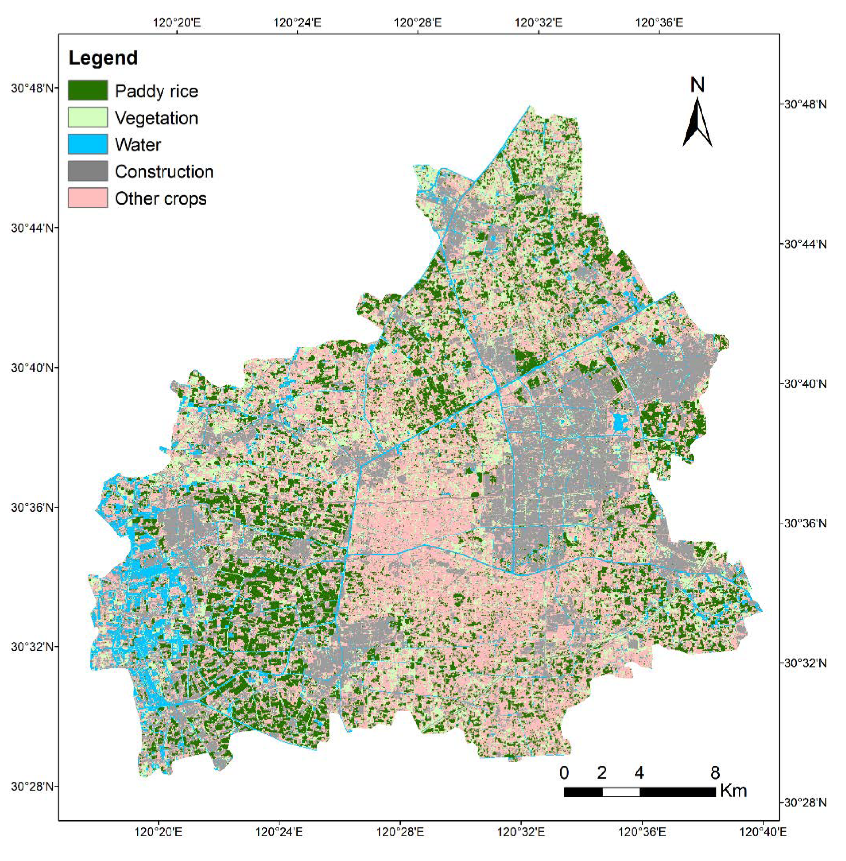
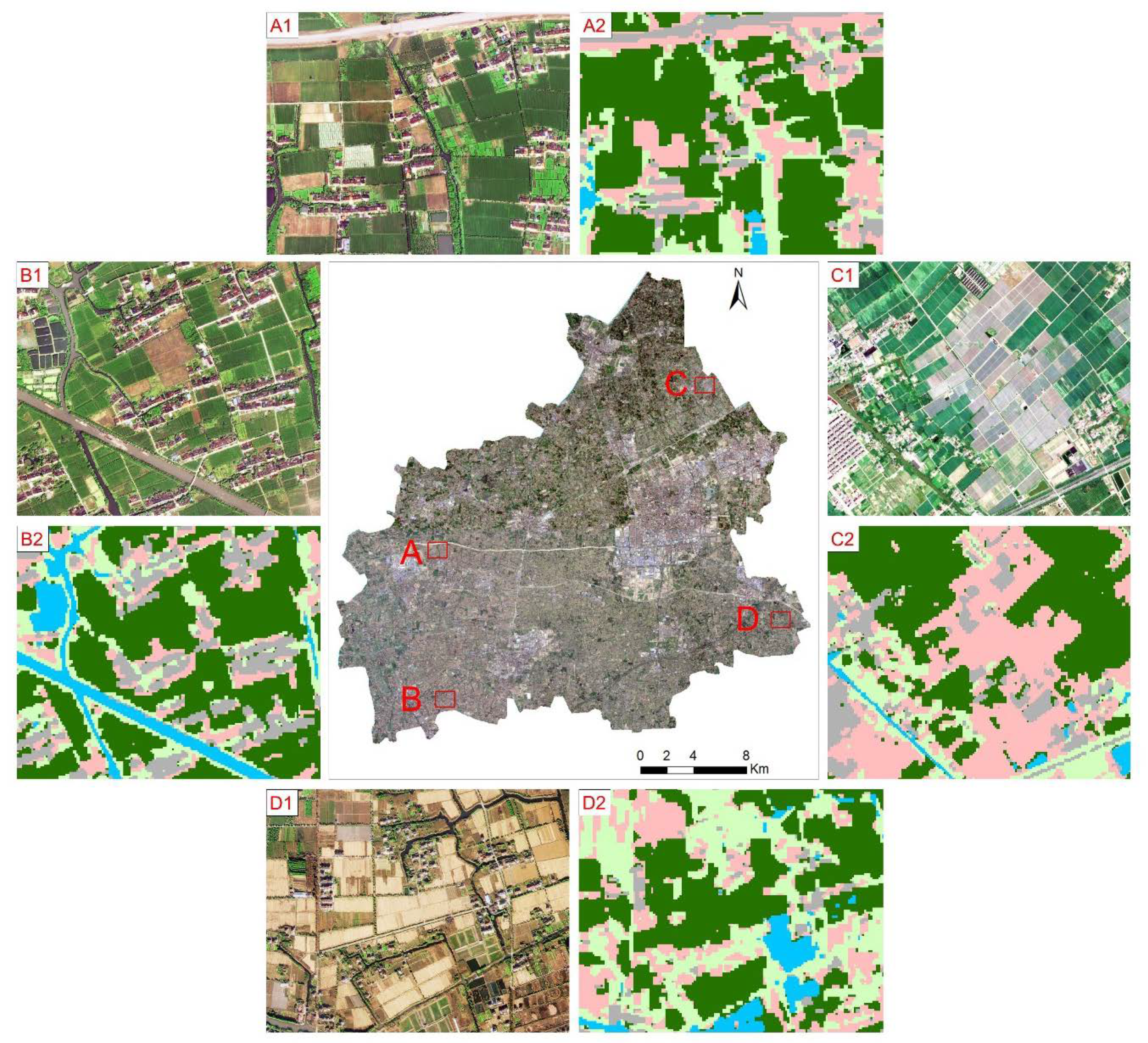
3.3. Paddy Rice Map
4. Discussion
5. Conclusions
Author Contributions
Funding
Conflicts of Interest
References
- Sarris, A. Rice in Global Markets. In Proceedings of the FAO Rice Conference 2004, Rome, Italy, 12–13 February 2004. [Google Scholar]
- Muthayya, S.; Sugimoto, J.D.; Montgomery, S.; Maberly, G.F. An overview of global rice production, supply, trade, and consumption. Ann. N. Y. Acad. Sci. 2014, 1324, 7–14. [Google Scholar] [CrossRef]
- Bouman, B. How much water does rice use. Management 2009, 69, 115–133. [Google Scholar]
- Dong, J.; Xiao, X. Evolution of regional to global paddy rice mapping methods: A review. ISPRS J. Photogramm. Remote Sens. 2016, 119, 214–227. [Google Scholar] [CrossRef]
- Jin, C.; Xiao, X.; Dong, J.; Qin, Y.; Wang, Z. Mapping paddy rice distribution using multi-temporal Landsat imagery in the Sanjiang Plain, northeast China. Front. Earth Sci. 2016, 10, 49–62. [Google Scholar] [CrossRef] [PubMed]
- Zhong, L.; Gong, P.; Biging, G.S. Efficient corn and soybean mapping with temporal extendability: A multi-year experiment using Landsat imagery. Remote Sens. Environ. 2014, 140, 1–13. [Google Scholar] [CrossRef]
- Xiao, X.; Boles, S.; Liu, J.; Zhuang, D.; Frolking, S.; Li, C.; Salas, W.; Moore, B., III. Mapping paddy rice agriculture in southern China using multi-temporal MODIS images. Remote Sens. Environ. 2005, 95, 480–492. [Google Scholar]
- Bazzi, H.; Baghdadi, N.; El Hajj, M.; Zribi, M.; Minh, D.H.T.; Ndikumana, E.; Courault, D.; Belhouchette, H. Mapping paddy rice using Sentinel-1 SAR time series in Camargue, France. Remote Sens. 2019, 11, 887. [Google Scholar] [CrossRef]
- Onojeghuo, A.O.; Blackburn, G.A.; Wang, Q.; Atkinson, P.M.; Kindred, D.; Miao, Y. Mapping paddy rice fields by applying machine learning algorithms to multi-temporal Sentinel-1A and Landsat data. Int. J. Remote Sens. 2018, 39, 1042–1067. [Google Scholar] [CrossRef]
- Xiao, X.; Boles, S.; Frolking, S.; Li, C.; Babu, J.Y.; Salas, W.; Moore, B., III. Mapping paddy rice agriculture in South and Southeast Asia using multi-temporal MODIS images. Remote Sens. Environ. 2006, 100, 95–113. [Google Scholar] [CrossRef]
- Yin, Q.; Liu, M.; Cheng, J.; Ke, Y.; Chen, X. Mapping Paddy Rice Planting Area in Northeastern China Using Spatiotemporal Data Fusion and Phenology-Based Method. Remote Sens. 2019, 11, 1699. [Google Scholar] [CrossRef]
- Torbick, N.; Salas, W.A.; Hagen, S.; Xiao, X. Monitoring rice agriculture in the Sacramento Valley, USA with multitemporal PALSAR and MODIS imagery. IEEE J. Sel. Top. Appl. Earth Obs. Remote Sens. 2010, 4, 451–457. [Google Scholar] [CrossRef]
- Zhang, Y.; Wang, C.; Wu, J.; Qi, J.; Salas, W.A. Mapping paddy rice with multitemporal ALOS/PALSAR imagery in southeast China. Int. J. Remote Sens. 2009, 30, 6301–6315. [Google Scholar] [CrossRef]
- Aschbacher, J.; Pongsrihadulchai, A.; Karnchanasutham, S.; Rodprom, C.; Paudyal, D.; Le Toan, T. Assessment of ERS-1 SAR data for rice crop mapping and monitoring. In Proceedings of the 1995 International Geoscience and Remote Sensing Symposium, IGARSS’95, Florence, Italy, 10–14 July 1995; pp. 2183–2185. [Google Scholar]
- Wu, F.; Wang, C.; Zhang, H.; Zhang, B.; Tang, Y. Rice crop monitoring in South China with RADARSAT-2 quad-polarization SAR data. IEEE Geosci. Remote Sens. Lett. 2010, 8, 196–200. [Google Scholar] [CrossRef]
- Clauss, K.; Ottinger, M.; Künzer, C. Mapping rice areas with Sentinel-1 time series and superpixel segmentation. Int. J. Remote Sens. 2018, 39, 1399–1420. [Google Scholar] [CrossRef]
- Nguyen, D.B.; Gruber, A.; Wagner, W. Mapping rice extent and cropping scheme in the Mekong Delta using Sentinel-1A data. Remote Sens. Lett. 2016, 7, 1209–1218. [Google Scholar] [CrossRef]
- Le Toan, T.; Ribbes, F.; Wang, L.-F.; Floury, N.; Ding, K.-H.; Kong, J.A.; Fujita, M.; Kurosu, T. Rice crop mapping and monitoring using ERS-1 data based on experiment and modeling results. IEEE Trans. Geosci. Remote Sens. 1997, 35, 41–56. [Google Scholar] [CrossRef]
- Guan, X.; Huang, C.; Liu, G.; Meng, X.; Liu, Q. Mapping rice cropping systems in Vietnam using an NDVI-based time-series similarity measurement based on DTW distance. Remote Sens. 2016, 8, 19. [Google Scholar] [CrossRef]
- Belgiu, M.; Csillik, O. Sentinel-2 cropland mapping using pixel-based and object-based time-weighted dynamic time warping analysis. Remote Sens. Environ. 2018, 204, 509–523. [Google Scholar] [CrossRef]
- Guan, X.; Liu, G.; Huang, C.; Meng, X.; Liu, Q.; Wu, C.; Ablat, X.; Chen, Z.; Wang, Q. An Open-Boundary Locally Weighted Dynamic Time Warping Method for Cropland Mapping. Isprs Int. J. Geo-Inf. 2018, 7, 75. [Google Scholar] [CrossRef]
- Li, M.; Bijker, W. Vegetable classification in Indonesia using Dynamic Time Warping of Sentinel-1A dual polarization SAR time series. Int. J. Appl. Earth Obs. Geoinf. 2019, 78, 268–280. [Google Scholar] [CrossRef]
- Chen, C.-F.; Son, N.-T.; Chen, C.-R.; Chang, L.-Y. Wavelet filtering of time-series moderate resolution imaging spectroradiometer data for rice crop mapping using support vector machines and maximum likelihood classifier. J. Appl. Remote Sens. 2011, 5, 053525. [Google Scholar] [CrossRef]
- McCloy, K.; Smith, F.; Robinson, M. Monitoring rice areas using Landsat MSS data. Int. J. Remote Sens. 1987, 8, 741–749. [Google Scholar] [CrossRef]
- Clauss, K.; Yan, H.; Kuenzer, C. Mapping paddy rice in China in 2002, 2005, 2010 and 2014 with MODIS time series. Remote Sens. 2016, 8, 434. [Google Scholar] [CrossRef]
- Kücük, C.; Taskın, G.; Erten, E. Paddy-rice phenology classification based on machine-learning methods using multitemporal co-polar X-band SAR images. IEEE J. Sel. Top. Appl. Earth Obs. Remote Sens. 2016, 9, 2509–2519. [Google Scholar] [CrossRef]
- Park, S.; Im, J.; Park, S.; Yoo, C.; Han, H.; Rhee, J. Classification and mapping of paddy rice by combining Landsat and SAR time series data. Remote Sens. 2018, 10, 447. [Google Scholar] [CrossRef]
- Teluguntla, P.; Thenkabail, P.S.; Oliphant, A.; Xiong, J.; Gumma, M.K.; Congalton, R.G.; Yadav, K.; Huete, A. A 30-m Landsat-derived cropland extent product of Australia and China using random forest machine learning algorithm on Google Earth Engine cloud computing platform. ISPRS J. Photogramm. Remote Sens. 2018, 144, 325–340. [Google Scholar] [CrossRef]
- Gumma, M.K.; Nelson, A.; Thenkabail, P.S.; Singh, A.N. Mapping rice areas of South Asia using MODIS multitemporal data. J. Appl. Remote Sens. 2011, 5, 053547. [Google Scholar] [CrossRef]
- Wang, J.; Yang, Y.; Mao, J.; Huang, Z.; Huang, C.; Xu, W. CNN-RNN: A unified framework for multi-label image classification. In Proceedings of the IEEE Conference on Computer Vision and Pattern Recognition, Las Vegas, NV, USA, 26–30 June 2016; pp. 2285–2294. [Google Scholar]
- Kussul, N.; Lavreniuk, M.; Skakun, S.; Shelestov, A. Deep learning classification of land cover and crop types using remote sensing data. IEEE Geosci. Remote Sens. Lett. 2017, 14, 778–782. [Google Scholar] [CrossRef]
- Zhang, M.; Lin, H.; Wang, G.; Sun, H.; Fu, J. Mapping paddy rice using a convolutional neural network (CNN) with Landsat 8 datasets in the Dongting Lake Area, China. Remote Sens. 2018, 10, 1840. [Google Scholar] [CrossRef]
- Sun, Z.; Di, L.; Fang, H. Using long short-term memory recurrent neural network in land cover classification on Landsat and Cropland data layer time series. Int. J. Remote Sens. 2019, 40, 593–614. [Google Scholar] [CrossRef]
- Clement, M.; Kilsby, C.; Moore, P. Multi-temporal synthetic aperture radar flood mapping using change detection. J. Flood Risk Manag. 2018, 11, 152–168. [Google Scholar] [CrossRef]
- Cai, Y.; Guan, K.; Peng, J.; Wang, S.; Seifert, C.; Wardlow, B.; Li, Z. A high-performance and in-season classification system of field-level crop types using time-series Landsat data and a machine learning approach. Remote Sens. Environ. 2018, 210, 35–47. [Google Scholar] [CrossRef]
- Sakoe, H.; Chiba, S. Dynamic programming algorithm optimization for spoken word recognition. IEEE Trans. Acoust. SpeechSignal Process. 1978, 26, 43–49. [Google Scholar] [CrossRef]
- Maus, V.; Câmara, G.; Cartaxo, R.; Sanchez, A.; Ramos, F.M.; De Queiroz, G.R. A time-weighted dynamic time warping method for land-use and land-cover mapping. IEEE J. Sel. Top. Appl. Earth Obs. Remote Sens. 2016, 9, 3729–3739. [Google Scholar] [CrossRef]
- Petitjean, F.; Inglada, J.; Gancarski, P. Satellite image time series analysis under time warping. IEEE Trans. Geosci. Remote Sens. 2012, 50, 3081–3095. [Google Scholar] [CrossRef]
- Berndt, D.J.; Clifford, J. Using dynamic time warping to find patterns in time series. In Proceedings of the KDD Workshop, Seattle, WA, USA, 31 July 1994; pp. 359–370. [Google Scholar]
- Hochreiter, S.; Schmidhuber, J. Long short-term memory. Neural Comput. 1997, 9, 1735–1780. [Google Scholar] [CrossRef] [PubMed]
- Understanding LSTM Networks. Available online: https://colah.github.io/posts/2015-08-Understanding-LSTMs (accessed on 16 June 2020).
- Goodfellow, I.; Bengio, Y.; Courville, A.; Bengio, Y. Deep Learning. MIT press Cambridge: Cambridge, MA, USA, 2016; pp. 226–227. [Google Scholar]
- Zhong, L.; Hu, L.; Zhou, H. Deep learning based multi-temporal crop classification. Remote Sens. Environ. 2019, 221, 430–443. [Google Scholar] [CrossRef]
- Qiu, B.; Li, W.; Tang, Z.; Chen, C.; Qi, W. Mapping paddy rice areas based on vegetation phenology and surface moisture conditions. Ecol. Indic. 2015, 56, 79–86. [Google Scholar] [CrossRef]
- Zhang, G.; Xiao, X.; Dong, J.; Kou, W.; Jin, C.; Qin, Y.; Zhou, Y.; Wang, J.; Menarguez, M.A.; Biradar, C. Mapping paddy rice planting areas through time series analysis of MODIS land surface temperature and vegetation index data. Isprs J. Photogramm. Remote Sens. 2015, 106, 157–171. [Google Scholar] [CrossRef]
- Xiao, X.; Boles, S.; Frolking, S.; Salas, W.; Moore, B., III; Li, C.; He, L.; Zhao, R. Observation of flooding and rice transplanting of paddy rice fields at the site to landscape scales in China using VEGETATION sensor data. Int. J. Remote Sens. 2002, 23, 3009–3022. [Google Scholar] [CrossRef]
- Chen, C.; McNairn, H. A neural network integrated approach for rice crop monitoring. Int. J. Remote Sens. 2006, 27, 1367–1393. [Google Scholar] [CrossRef]


| SAR Images | |
|---|---|
| Sensor | Sentinel-1A |
| Data level | Level-1 ground range detected |
| Spatial resolution | 10 m |
| Wavelength | C band |
| Polarization | VV |
| Pass | Ascending |
| Acquisition mode | IW |
| Acquisition date (23 successive images with 12-day interval) | 4 April 2018 |
| 16 April 2018 | |
| 28 April 2018 | |
| …… 24 December 2018 | |
| Multispectral Optical Images | |
|---|---|
| Sensor | Sentinel-2A, Sentinel-2B |
| Data level | Level-1C |
| Spatial resolution | 10 m, 20 m |
| Band | B2, B3, B4, B5, B6, B7, B8, B8a, B11, B12 |
| Acquisition date (11 images) | 9 April 2018 |
| 19 April 2018 | |
| 4 May 2018 | |
| 9 May 2018 | |
| 18 June 2018 | |
| 18 July 2018 | |
| 23 July 2018 | |
| 28 July 2018 | |
| 7 August 2018 | |
| 1 October 2018 | |
| 10 November 2018 | |
| Learning Rate | Dropout Rate | Batch Size | Loss Function | Optimizer |
|---|---|---|---|---|
| 0.001 | 0.5 | 64 | Categorical cross-entropy | Adam algorithm |
| Experiment | OA | Paddy Rice PA | Paddy Rice UA | Paddy Rice Support | Kappa | |
|---|---|---|---|---|---|---|
| Scheme 1 | Supervised | 0.937 | 0.904 | 0.917 | 2281 | 0.921 |
| Weakly supervised | 0.854 | 0.981 | 0.961 | 2281 | 0.817 | |
| Scheme 2 | Supervised | 0.973 | 0.968 | 0.972 | 2281 | 0.966 |
| Weakly supervised | 0.986 | 0.985 | 0.993 | 2281 | 0.982 | |
| Scheme 3 | Supervised | 0.982 | 0.988 | 0.987 | 913 | 0.978 |
| Weakly supervised | 0.989 | 0.996 | 0.984 | 913 | 0.986 | |
| Paddy Rice | Vegetation | Water | Construction | Other Crops | |
|---|---|---|---|---|---|
| Paddy rice | 2092 | 54 | 0 | 23 | 112 |
| Vegetation | 42 | 2276 | 3 | 4 | 66 |
| Water | 5 | 0 | 2118 | 24 | 0 |
| Construction | 3 | 0 | 21 | 3015 | 2 |
| Other crops | 173 | 158 | 7 | 72 | 1885 |
| PA | 0.904 | 0.915 | 0.986 | 0.961 | 0.913 |
| UA | 0.917 | 0.948 | 0.986 | 0.99 | 0.821 |
| OA | 0.937 | ||||
| Kappa | 0.921 | ||||
| Paddy Rice | Vegetation | Water | Construction | Other Crops | |
|---|---|---|---|---|---|
| Paddy rice | 2193 | 12 | 0 | 6 | 70 |
| Vegetation | 6 | 2066 | 0 | 58 | 261 |
| Water | 6 | 0 | 2091 | 16 | 34 |
| Construction | 0 | 50 | 2 | 2742 | 247 |
| Other crops | 30 | 775 | 39 | 163 | 1288 |
| PA | 0.981 | 0.712 | 0.981 | 0.919 | 0.678 |
| UA | 0.961 | 0.864 | 0.974 | 0.902 | 0.561 |
| OA | 0.854 | ||||
| Kappa | 0.817 | ||||
Publisher’s Note: MDPI stays neutral with regard to jurisdictional claims in published maps and institutional affiliations. |
© 2020 by the authors. Licensee MDPI, Basel, Switzerland. This article is an open access article distributed under the terms and conditions of the Creative Commons Attribution (CC BY) license (http://creativecommons.org/licenses/by/4.0/).
Share and Cite
Wang, M.; Wang, J.; Chen, L. Mapping Paddy Rice Using Weakly Supervised Long Short-Term Memory Network with Time Series Sentinel Optical and SAR Images. Agriculture 2020, 10, 483. https://doi.org/10.3390/agriculture10100483
Wang M, Wang J, Chen L. Mapping Paddy Rice Using Weakly Supervised Long Short-Term Memory Network with Time Series Sentinel Optical and SAR Images. Agriculture. 2020; 10(10):483. https://doi.org/10.3390/agriculture10100483
Chicago/Turabian StyleWang, Mo, Jing Wang, and Li Chen. 2020. "Mapping Paddy Rice Using Weakly Supervised Long Short-Term Memory Network with Time Series Sentinel Optical and SAR Images" Agriculture 10, no. 10: 483. https://doi.org/10.3390/agriculture10100483
APA StyleWang, M., Wang, J., & Chen, L. (2020). Mapping Paddy Rice Using Weakly Supervised Long Short-Term Memory Network with Time Series Sentinel Optical and SAR Images. Agriculture, 10(10), 483. https://doi.org/10.3390/agriculture10100483