Identification of Ratholes in Desert Steppe Based on UAV Hyperspectral Remote Sensing
Abstract
1. Introduction
2. Materials and Methods
2.1. Overview of the Study Area
2.2. Brief Description of the Experimental Equipment
2.3. Data Acquisition
3. Data Processing
3.1. Data Pre-Processing
3.2. Extraction of Feature Image Elements and Spectral Curve Analysis
3.3. Principal Component Analysis
4. Result
4.1. Rathole Feature Extraction
4.2. Non-Rathole Area Characterization
4.3. Classification Accuracy Validation
| Color | Name | Number of Pixels | Max Value | Min Value | |
|---|---|---|---|---|---|
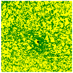 | Rathole | 655 | 2.195495 | 1.126505 | |
| Bare soil | 148,916 | 0.306244 | −0.019260 | ||
| Vegetation | 100,429 | 0.631748 | 0.306244 | ||
| Total | 250,000 |
5. Discussion
6. Conclusions
Author Contributions
Funding
Institutional Review Board Statement
Informed Consent Statement
Data Availability Statement
Conflicts of Interest
References
- Pan, Q.; Xue, J.; Tao, J.; Xu, M.; Zhang, W. Current status of grassland degradation and measures for grassland restoration in northern China. Chin. Sci. Bull. 2018, 63, 1642–1650. [Google Scholar] [CrossRef]
- Guo, B.; Wei, C.; Yu, Y.; Liu, Y.; Li, J.; Meng, C.; Cai, Y. The Dominant Influencing Factors of Desertification Changes in the Source Region of Yellow River: Climate Change or Human Activity? Sci. Total Environ. 2022, 813, 152512. [Google Scholar] [CrossRef] [PubMed]
- Li, H.; Li, X.; Yao, Q.; Li, Q. Biolog-ECO analysis of rhizosphere soil microbial community characteristics of five different plants in two different grasslands. Microbiol. China 2020, 47, 2947–2958. [Google Scholar] [CrossRef]
- Xie, Y.; Wang, Y.; Wu, W.; Guan, Y. Research Progress on Parasites Infection in Rodents. J. Pathog. Biol. 2022, 17, 1356–1360. [Google Scholar] [CrossRef]
- Feng, Q.; Liu, M.; Bai, Y.; Huang, Y.; Li, Y.; Wang, D.; Shi, W.; Wang, S.; Si, H.; Wang, H. Advances in research on vaccines for rodent-borne diseases. Chin. J. Vector Biol. Control 2022, 33, 760–764. [Google Scholar] [CrossRef]
- Tang, H.; Gao, W.; Xu, L.; Yan, R.; Chen, B.; Xin, X. Monitoring forage harvesting area in semi-arid pasture based on Landsat TM images. Trans. Chin. Soc. Agric. Eng. 2015, 31, 160–167. [Google Scholar] [CrossRef]
- Shen, B.; Wei, Y.; Ma, L.; Xu, D.; Ding, L.; Hou, L.; Qin, Q.; Xin, X. Spatiotemporal changes and drivers of fractional vegetation cover in Inner Mongolia grassland of China. Trans. Chin. Soc. Agric. Eng. 2022, 38, 118–126. [Google Scholar] [CrossRef]
- Lin, Y. A Method for Estimating the Number of Rodents in Grasslands by Estimating Their Orifices. Chin. J. Zool. 1975, 1, 41–42. [Google Scholar] [CrossRef]
- Hua, R.; Zhou, R.; Bao, D.; Dong, K.; Tang, Z.; Hua, L. A study of UAV remote sensing technology for classifying the level of plateau pika damage to alpine rangeland. Acta Prataculturae Sin. 2022, 31, 165–176. [Google Scholar] [CrossRef]
- Zumo, I.M.; Hashim, M.; Hassan, N. Mapping Grass above-Ground Biomass of Grazing-Lands Using Satellite Remote Sensing. Geocarto Int. 2022, 37, 4843–4856. [Google Scholar] [CrossRef]
- Du, R.; Chen, J.; Zhang, Z.; Xu, Y.; Zhang, X.; Yin, H.; Yang, N. Inversing soil salinity under vegetation cover using Sentinel-2 multispectral satellite remote sensing. Trans. Chin. Soc. Agric. Eng. 2021, 37, 107–115. [Google Scholar] [CrossRef]
- Dutta, S.; Sharma, S.A.; Khera, A.P.; Ajai; Yadav, M.; Hooda, R.S.; Mothikumar, K.E.; Manchanda, M.L. Accuracy Assessment in Cotton Acreage Estimation Using Indian Remote Sensing Satellite Data. ISPRS J. Photogramm. Remote Sens. 1994, 49, 21–26. [Google Scholar] [CrossRef]
- Wen, A.; Zheng, J.; Chen, M.; Mu, C.; Ma, T. Monitoring Mouse-Hole Density by Rhombomys opimus in Desert Forests with UAV Remote Sensing Technology. Sci. Silvae Sin. 2018, 54, 186–192. [Google Scholar] [CrossRef]
- Du, M.; Noguchi, N.; Itoh, A.; Shibuya, Y. Multi-Temporal Monitoring of Wheat Growth by Using Images from Satellite and Unmanned Aerial Vehicle. Int. J. Agric. Biol. Eng. 2017, 10, 1–13. [Google Scholar] [CrossRef]
- Zhu, X.; Bi, Y.; Du, J.; Gao, X.; Zhang, T.; Pi, W.; Zhang, Y.; Wang, Y.; Zhang, H. Research on Deep Learning Method Recognition and a Classification Model of Grassland Grass Species Based on Unmanned Aerial Vehicle Hyperspectral Remote Sensing. Grassl. Sci. 2023, 69, 3–11. [Google Scholar] [CrossRef]
- Pi, W.; Du, J.; Bi, Y.; Gao, X.; Zhu, X. 3D-CNN Based UAV Hyperspectral Imagery for Grassland Degradation Indicator Ground Object Classification Research. Ecol. Inform. 2021, 62, 101278. [Google Scholar] [CrossRef]
- Xie, X.; Nan, X.; Li, Y.; Li, F.; Liu, B.; Wu, S.; Wang, H. An analysis of the epidemiological characteristics of animal plague in Siziwang banner, Ulanqab, Inner Mongolia, China, 2009–2019. Chin. J. Vector Biol. Control 2020, 31, 602–606. [Google Scholar] [CrossRef]
- Wang, G.; Han, H.; Carranza, E.J.M.; Guo, S.; Guo, K.; Xiao, K. Tensor-Based Low-Rank and Sparse Prior Information Constraints for Hyperspectral Image Denoising. IEEE Access 2020, 8, 102935–102946. [Google Scholar] [CrossRef]
- Filla, V.A.; Coelho, A.P.; Bettiol, J.V.T.; Leal, F.T.; Lemos, L.B.; Rosalen, D.L. Model Performance in Estimating the Yield of Common Bean Cultivars. Rev. Ciência Agronômica 2023, 54, e20217835. [Google Scholar] [CrossRef]
- Wang, M.; Luo, Y.; Zhang, Z.; Xie, Q.; Wu, X.; Ma, X. Recent advances in remote sensing of vegetation phenology: Retrieval algorithm and validation strategy. Natl. Remote Sens. Bull. 2022, 26, 431–455. [Google Scholar] [CrossRef]
- Liu, H.Q.; Huete, A. A Feedback Based Modification of the NDVI to Minimize Canopy Background and Atmospheric Noise. IEEE Trans. Geosci. Remote Sens. 1995, 33, 457–465. [Google Scholar] [CrossRef]
- Lichtenthaler, H.K.; Lang, M.; Sowinska, M.; Heisel, F.; Miehé, J.A. Detection of Vegetation Stress via a New High Resolution Fluorescence Imaging System. J. Plant Physiol. 1996, 148, 599–612. [Google Scholar] [CrossRef]
- Buschmann, C.; Nagel, E. In Vivo Spectroscopy and Internal Optics of Leaves as Basis for Remote Sensing of Vegetation. Int. J. Remote Sens. 1993, 14, 711–722. [Google Scholar] [CrossRef]
- Wang, H.; Shi, R.; Liu, P.; Gao, W. Dual NDVI Ratio Vegetation Index:A Kind of Vegetation lndex Assessing Leaf Carotenoid Content Based on Leaf Optical Properties Model. Spectrosc. Spectr. Anal. 2016, 36, 2189–2194. [Google Scholar]
- Perry, C.R.; Lautenschlager, L.F. Functional Equivalence of Spectral Vegetation Indices. Remote Sens. Environ. 1984, 14, 169–182. [Google Scholar] [CrossRef]
- Huete, A.R. A Soil-Adjusted Vegetation Index (SAVI). Remote Sens. Environ. 1988, 25, 295–309. [Google Scholar] [CrossRef]
- Zhang, T.; Du, J.; Zhang, H.; Pi, W.; Gao, X.; Zhu, X. Research on recognition method of desert steppe rat hole based on unmanned aerial vehicle hyperspectral. J. Optoelectron. Laser 2022, 33, 120–126. [Google Scholar] [CrossRef]
- Marín, J.; Yousfi, S.; Mauri, P.V.; Parra, L.; Lloret, J.; Masaguer, A. RGB Vegetation Indices, NDVI, and Biomass as Indicators to Evaluate C3 and C4 Turfgrass under Different Water Conditions. Sustainability 2020, 12, 2160. [Google Scholar] [CrossRef]
- Gao, X.; Du, J.; Bi, Y.; Pi, W.; Zhu, X.; Zhang, Y. Spectral Characteristics Analysis and Extraction of Micro-Patches Based on the Hyperspectral Desert Steppe Images. INMATEH Agric. Eng. 2022, 67, 128–136. [Google Scholar] [CrossRef]

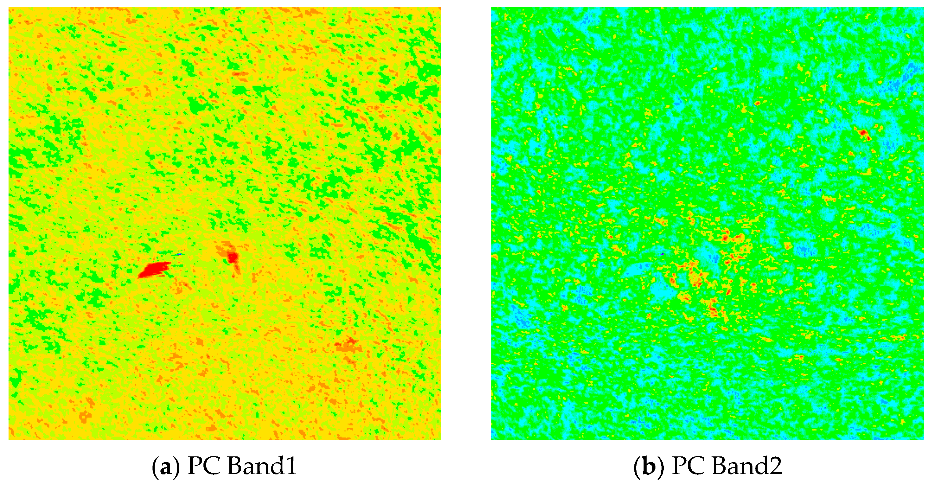


| PC Band | 400~700 nm | 400~1000 nm | ||
|---|---|---|---|---|
| Contribution Rate | Cumulative Contribution Rate (%) | Contribution Rate | Cumulative Contribution Rate (%) | |
| 1 | 0.7602 | 76.02 | 0.7735 | 77.35 |
| 2 | 0.2211 | 98.13 | 0.1581 | 93.16 |
| 3 | 0.0094 | 99.07 | 0.0265 | 95.81 |
| 4 | 0.0026 | 99.33 | 0.0119 | 97.00 |
| 5 | 0.0014 | 99.47 | 0.0066 | 97.66 |
| 6 | 0.0012 | 99.59 | 0.0050 | 98.16 |
| Vegetation Index | Calculation Formula | References |
|---|---|---|
| Normalized difference vegetation index | [21,22] | |
| Enhanced vegetation index | [23] | |
| Ratio vegetation index | [24] | |
| Difference vegetation index | [25] | |
| Soil-adjusted vegetation index | [26] |
| Classification Result | |||
|---|---|---|---|
| Rathole | Non-Rathole | Sum | |
| Rathole | 143 | 10 | 153 |
| Non-rathole | 12 | 335 | 347 |
| Sum | 155 | 345 | 500 |
Disclaimer/Publisher’s Note: The statements, opinions and data contained in all publications are solely those of the individual author(s) and contributor(s) and not of MDPI and/or the editor(s). MDPI and/or the editor(s) disclaim responsibility for any injury to people or property resulting from any ideas, methods, instructions or products referred to in the content. |
© 2023 by the authors. Licensee MDPI, Basel, Switzerland. This article is an open access article distributed under the terms and conditions of the Creative Commons Attribution (CC BY) license (https://creativecommons.org/licenses/by/4.0/).
Share and Cite
Gao, X.; Bi, Y.; Du, J. Identification of Ratholes in Desert Steppe Based on UAV Hyperspectral Remote Sensing. Appl. Sci. 2023, 13, 7057. https://doi.org/10.3390/app13127057
Gao X, Bi Y, Du J. Identification of Ratholes in Desert Steppe Based on UAV Hyperspectral Remote Sensing. Applied Sciences. 2023; 13(12):7057. https://doi.org/10.3390/app13127057
Chicago/Turabian StyleGao, Xinchao, Yuge Bi, and Jianmin Du. 2023. "Identification of Ratholes in Desert Steppe Based on UAV Hyperspectral Remote Sensing" Applied Sciences 13, no. 12: 7057. https://doi.org/10.3390/app13127057
APA StyleGao, X., Bi, Y., & Du, J. (2023). Identification of Ratholes in Desert Steppe Based on UAV Hyperspectral Remote Sensing. Applied Sciences, 13(12), 7057. https://doi.org/10.3390/app13127057


