1. Introduction
The Saudi ministry of transportation (SMOT) retained a total estimated road length of 627,000 km in 2014, of which 151,000 km were highways connecting major regions of the Kingdom of Saudi Arabia (KSA) with international borders and serving as linked roads between major cities of the kingdom [
1,
2]. The majority of these highways are two-lane, and some of them do not have median strips. The SMOT has been working on a plan to upgrade these highways over time. Highway 10 in Saudi Arabia now holds the title for the world’s longest straight road, passing across the Rub’ al-Khali desert for 256 km (159 miles), breaking the former record holder, Australia’s Eyre Highway, by 110 km (68 miles) on 19 February 2018 [
3,
4]. The permitted speed of vehicles on these highways has also been increased from 120 km/h to 140 km/h. SMOT has taken various steps to secure vehicles on the highways, such as installing security cameras, heavy fines for violations, widening bridges, roadside parking, protection fences, direction signs, etc. However, traffic accidents on these highways are still recorded daily. One of the significant issues is the lack of prompt post-crash care for passengers, resulting in fatalities [
5,
6,
7].
KSA has reported 86,000 deaths and 611,000 injuries in road traffic accidents (RTAs) over the last two decades, with 7% resulting in lifelong disability. RTAs are a serious health concern in KSA, with 19 people dead and 4 wounded per hour. The most vulnerable age groups are the young and economically productive [
8,
9,
10]. One of the reasons for increasing fatality is the lack of a timely health service for the passengers traveling on long-distance highways. Therefore, there is a need to develop a comprehensive traveler safety solution for providing timely help in case of road accidents occurring on highways. The evolving CET such as the Internet of Things (IoT), 5G, and clouds can provide a strong foundation for supporting significant real-time services on these highways by providing emergency assistance, such as first aid, medical aid, and police protection, on time in the event of an accident.
IoT is already helping to maintain road safety by providing vehicle maintenance, navigation, improved circulation, and monitoring the state of the roads. A huge amount of IoT data are obtained through IoT sensors attached to vehicles, which helps maintain road safety [
11,
12,
13]. The advances in cloud computing address the increasing transportation problems, like heavy traffic, congestion, and vehicle safety by storing the data obtained through modern vehicles. Modern cars, which are increasingly equipped with many sensors, actuators, and communication devices (mobile phones, PS devices, and embedded computers), create a large amount of real-time data stored in clouds [
14,
15]. Another CET, 5G, is very useful in road safety since it allows for cloud-based roadside accident video reporting by providing fast data transmission from IoT sensors (attached to vehicles) to the cloud [
16,
17,
18].
The Saudi Arabian government introduced the SAHER traffic control system in 2009, which means “watchful” in Arabic [
19]. The goal of SAHER was to reduce traffic accidents and improve general traffic efficiency throughout the kingdom. It entails the implementation of an intelligent transportation system that incorporates the most up-to-date technologies in traffic enforcement, traffic management subsystems, and services to improve highway network safety. SAHER does this via improving transportation infrastructure, reducing mortality rates, and reducing traffic congestion. The system is based on a digital camera network that is linked to and controlled by the Ministry of Interior’s National Information Centre (NIC). The SAHER system is effective in indirectly lowering accident instances by enforcing traffic infringement regulations; however, if an accident occurs on a long-distance highway and there is no SAHER camera nearby to notice the occurrence, how can the passenger be helped in order to save his life? To address this problem, we have suggested a system based on modern CET that not only detects accidents anywhere on the roadway but also takes quick action. This will save a human life by giving medical and legal assistance to the victim on time.
Keeping in view the importance of IoT, Cloud, and 5G for providing real-time services [
20,
21,
22], this paper aims to use these CET for providing safety to the passengers traveling on long-distance highways of KSA in particular. We developed RTSHPMP based on IoT, 5G, and Cloud that will help in providing timely medical and legal help to the victim in the case of any unusual road incidents (accident, robbery, car damage, etc.). The suggested model is described in-depth in the research methods section.
1.1. Paper Contribution
This paper makes the following significant contributions:
It investigates the existing traffic management system to determine how passengers on highways receive first-aid in the event of an emergency;
It investigates the role of modern CET in improving traffic management;
It proposes a model solution for improving passenger security on KSA highways using cutting-edge technologies;
It elaborates the detailed operation of a model using an algorithm and flow chart;
It evaluates the proposed model using a case study;
It compares results with existing system to show how the proposed model is efficient in terms of providing quick first-aid to the passengers traveling on KSA highways.
1.2. Paper Organization
The other sections of the article are organized as follows:
Section 2 presents existing work in the field of passenger safety on Saudi Arabian highways.
Section 3 describes the proposed model, followed by
Section 4, which evaluates the suggested RTSHPMP using a case study. The study limitations and practical implications are discussed in
Section 5. The final section of the study concludes by outlining potential research directions.
Table 1 provides the detail of acronyms used in the study for a better understanding of the abbreviations used.
2. Literature Review
This section presents an overview of the existing work undertaken in real-time security, health, and privacy monitoring for highways using CET with a particular focus on KSA highways.
Paper [
23] proposes a smart traffic monitoring system based on unmanned aerial vehicles (UAVs) and 5G technologies. This traffic monitoring system addresses the shortcomings of the SAHER system already used in Saudi Arabia. It has been noted that the number of accidents and fatalities can be reduced by overcoming the SAHER system’s existing restrictions and loopholes. According to the predicted findings, when such breaches are eliminated, the number of accidents per year drops to 299,317, resulting in 4868 deaths and 33,199 injuries in the first year. In the next five years, deaths and injuries reduce to 3745 and 16,600, respectively. According to paper [
16], the major issue for high data rate real-time video transmission is current 4G wireless data performance. However, with the advent of 5G technology, this problem may be alleviated due to the higher data rates available with 5G. Using 5G-enabled vehicular cloud networks (VCNs) to deliver accident-occurring recordings to the appropriate authorities in real-time, roadside accident live video reporting services might become a reality. The suggested three-way handshake protocol can prevent attackers from accessing private/sensitive data/information acquired by built-in video sensors in cars. Paper [
24] provides a thorough examination of contemporary technologies (IoT, 5G, and Cloud) and their implications for improving an intelligent transportation system’s ability to monitor and regulate traffic congestion.
The article [
25] explores the security and privacy issues in the transportation system and the vehicular IoT environment in an SDN-enabled 5G vehicular ad hoc network (VANET). The vehicular IoT services, such as real-time cloud-based video reports and trust management on vehicular communications, are supported by a blockchain-based security architecture. It further discusses the SDN-enabled 5G-VANET architecture and the blockchain-based framework’s scheduling methods in detail. The numerical simulation findings further demonstrate that malicious vehicle nodes or communications can be identified effectively, with acceptable overhead and network performance impacts in large-scale scenarios.
With the convergence of VANETs, software-defined networks, 5G, and mobile edge computing technologies, article [
26] proposes a unique four-tier architecture for urban traffic management. In a more dispersed and dynamic manner, the suggested architecture enables better communication and faster response performance. In the case of a quick accident rescue, the rescue time can be considerably reduced. Vehicle geolocation, data pre-fetching, traffic signal control, and traffic prediction are among the key technologies addressed. The suggested innovative architecture has significant promise for reducing traffic congestion and enhancing urban traffic management efficiency.
In paper [
27], an intelligent traffic management system (ITMS) was presented to prioritize emergency vehicles by merging the concepts of VANET and IoT to improve ambulance flow in metropolitan areas. It demonstrates a way to detect and prevent traffic signal hacking, which is a fairly prevalent problem nowadays. Using hacked and non-hacked traffic lights, the distance between intersections and emergency cars was calculated to accomplish the desired travel time of emergency vehicles with the least delay. The suggested approach distinguishes between emergency signals of varying priority and prevents hostile actors from issuing misleading alerts. The experiments demonstrate that the proposed system outperformed others in terms of time restrictions, allowing emergency assistance to be provided in the quickest period feasible. The suggested method reduces the time it takes for accident victims to receive medical help and transfer essential patients and medicines.
Table 2 provides the comparative analysis of existing traffic management solutions. The results of
Table 2 and some other studies [
28,
29,
30,
31,
32,
33] show that the existing solutions mainly focused on intelligent transportation to reduce the accident ratio, traffic congestion, and the passing of emergency vehicles in cities. To the best of our knowledge, there has not been any research on passenger safety on Saudi highways, especially providing medical and legal facilities in case of a post-crash incident. To fill this gap, this paper proposes a model RTSHPMP based on IoT, cloud, and 5G to facilitate passengers traveling on Saudi highways. RTSHPMP aims to provide timely health and legal facilities to traveler in the case of an accident. The details of the RTSHPMP are given in
Section 3. Before going into details of the proposed methodology, we provide a preliminary investigation in the next subsection.
Preliminary Investigations
Before proceeding towards the proposed methodology, there is a need to understand the problems faced by the conventional approach to passenger safety in order to know the current state of the art and the need for the proposed model. This will also help in the analysis and comparison of the proposed methodology.
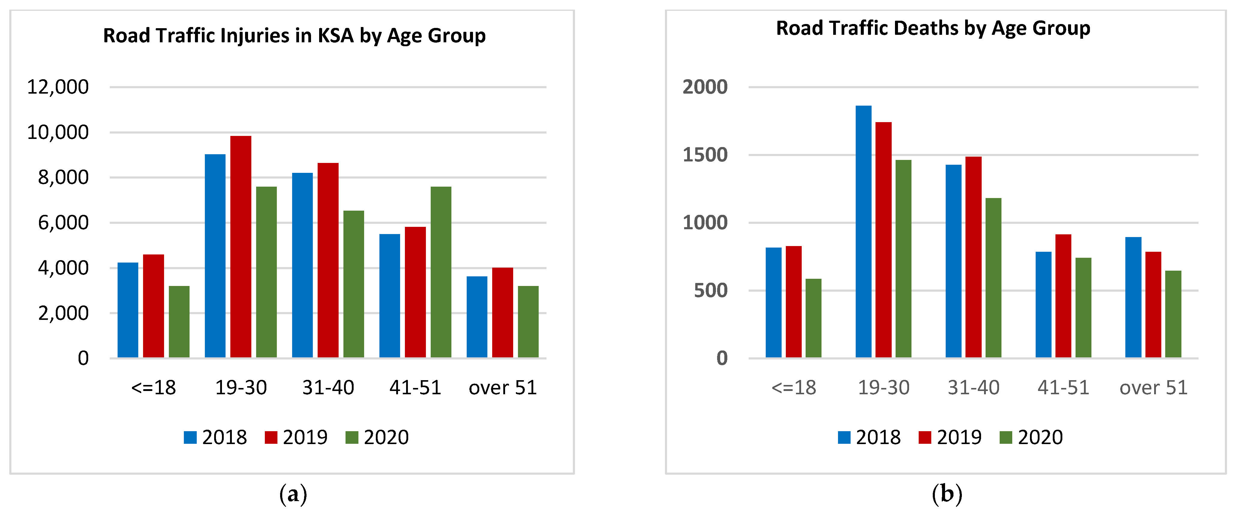
RTAs are a common problem worldwide. However, they are one of the leading causes of injury and death in KSA. The ministry of health’s statistics [
34] show the fatality rate linked with roadside accidents, as illustrated in
Figure 1a–d. The statistics of
Figure 1a–d show that RTAs are one of the most common problems that need to be given attention. Providing timely help to a passenger in the case of an accident can help reduce fatalities. Although SMOT has taken various steps in the last two decades to remove these accidents, still one of the major reasons for fatalities is the lack of timely help in post-crash events, especially on Saudi highways which are considered the world’s largest long roads. Most of the highways are surrounded by dessert and unpopulated areas due to the geography of the kingdom. In such a situation, timely medical and legal help to the passengers on these highways can save human life and assets.
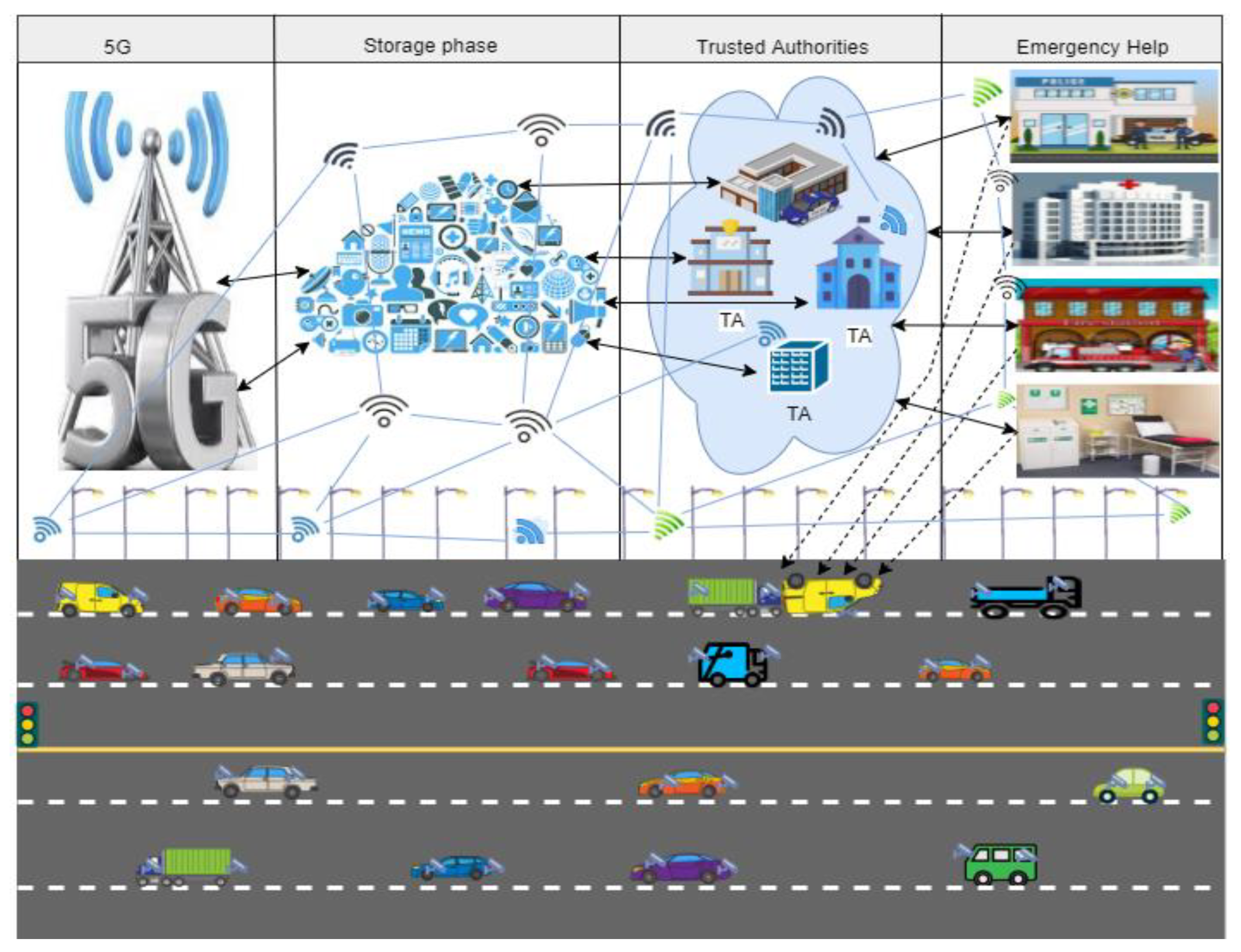
3. Proposed Methodology
IoT, cloud and 5G are CET that have improved nearly every aspect of life and these benefits can also be leveraged for travelers’ safety on KSA highways. To improve travelers’ safety on these highways, information of each vehicle should be collected in its proximity e.g., vehicle ID, passenger information, location, etc., through the front and back IoT-based cameras. The data are collected seamlessly around the clock using the video devices in cars through 5G. The collected data are stored in the cloud for further processing. Thus as mentioned in research [
35,
36,
37] these technologies can be helpful in case of accidents on these highways by providing timely medical and legal help through the available information. Keeping in view the benefits of these technologies, this research proposed an RTSHPMP, as shown in
Figure 2.
3.1. Communication Layer
The first layer of the RTSHPMP is the communication layer. This layer uses 5G technology to transmit data collected through the IoT-based cameras installed on the vehicles traveling on highways. The traveler’s vehicle is equipped with dual cameras that fetch real-time passenger data traveling on the road.
3.2. Storage Layer
The second layer of the RTSHPMP is the storage layer. It stores the collected data of vehicles on the cloud for further processing and decision making. These data are only accessible to TAs for maintaining the privacy of travelers’ data.
The RTSHPMP is divided into five layers, the detail of each layer is given in subsequent paragraphs
3.3. Image-Processing Scheme
The image-processing scheme will work on the third layer of RTSHPMP to identify the accidental vehicle among all stored data, and will be used for automatic monitoring of stored images. There are many reasons for using the image-processing scheme: firstly, decision making will be fast; secondly, no human intervention is required to continuously monitor the stored data; third, the results will be more reliable. If an accident is detected as a result of image processing, an alarm will be raised to take appropriate action.
3.4. Trusted Authorities
The fourth layer of the RTSHPMP is TAs, TAs are the governmental bodies responsible for monitoring highway traffic and providing legal and medical help to the passengers traveling on these roads [
38,
39,
40,
41]. If any unusual event (accident, robbery, etc.,) occurs on the road, TAs receive an alarm. After getting intimation of an unusual event, TA analyses the data stored on the cloud, including vehicle and passenger information and videos of the incident. TAs also take the data of other vehicles traveling on the same highway to collect the pieces of evidence for the event that occurred. Based on the analysis of collected data, TAs decide to inform the related local and national authorities (e.g., police, first aid, hospital, fire brigade, etc.).
3.5. Emergency Help
The fifth layer of the RTSHPMP is emergency help (ERH). ERH includes authorities such as police, first aid, hospital, and fire brigade, which are responsible for providing legal and medical help to the passenger so that passenger life and assets could be saved in case of an accident.
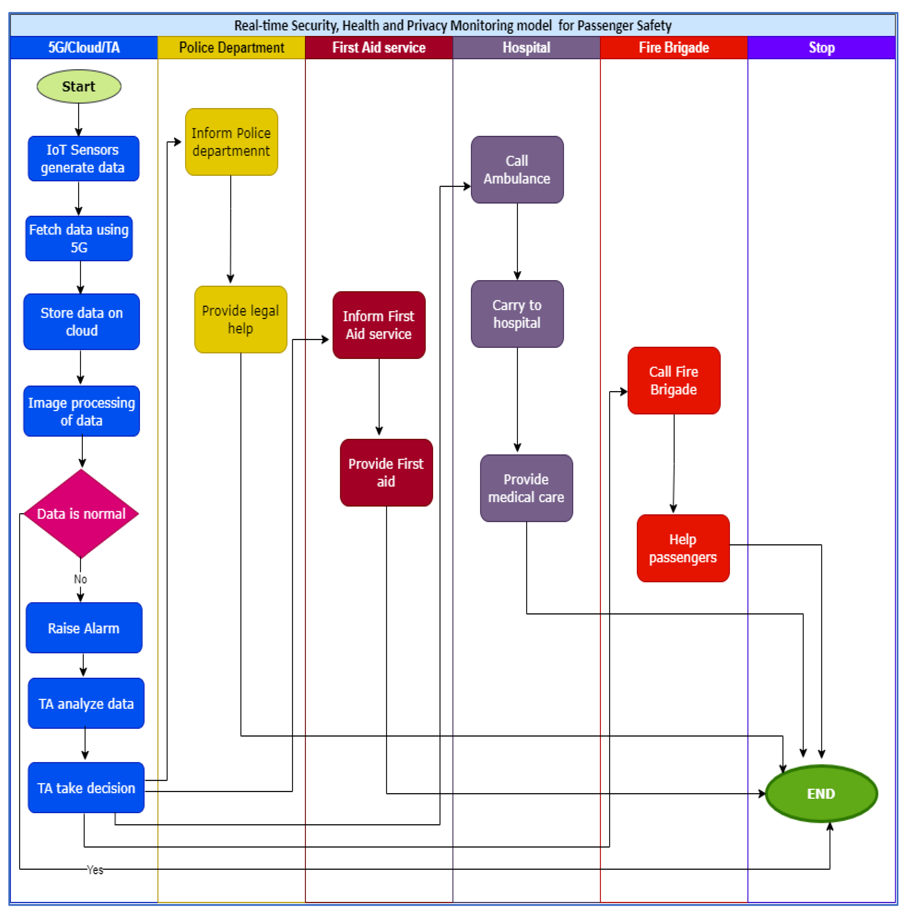
The detailed working of RTSHPMP is shown in our Algorithm 1 and flow chart in
Figure 3.
| Proposed Algorithm 1 |
| are vehicles on the highway, Dn = Normal data, De = Exceptional data, = victim vehicles, = Vehicles in front of victim vehicles, . = Vehicles at the back of victim vehicles, trusted authorities, = legal help, = medical help, = local police department, =Regional police department, = initial first aid, = Fire Brigade, = hospital, = ambulance service, = incident vide, = IoT-based front cameras in the front of a vehicle, = IoT-based front cameras in the back of a vehicle |
1. Begin
2. 5G CollectData ( //collect data of vehicles travelling on highways using 5G
3. Cloud Store Data ( ) //Store the data of vehicles on Cloud
4. AnalyseData () //analyze stored data on cloud through
5. If Collected Data (vi) Dn Then go to step 44 else
6. FetchData (cloud
7. AnalyseData (
8. Checkhelptype ( )
9. {
10. If ( equired legal help then call
11. else if ( required medical help then check Intensity (
12. If Intensity ( = normal then call
13. else If Intensity ( = critical then call or call
14. }
15.
16. {
17. Inform //inform the local and regional police department
18. }
19.
20. {
21. Inform local first aid service //in case of minor injury
22. }
23.
24. {
25. Call and send passengers to // in case of critical injury
26. }
27.
28. {
29. Inform // in case of fire in
30. }
31. AnalyseData (
32. {
33. CaptureInfo (Vehicle id, 3d picture) IoT
34. SendInfo (Vehicle id, 3d picture) 5G
35. Store info (Vehicle id, 3d picture)Cloud
36. Imageprocessing (3d picture) Imageprocessing scheme
37. If image is normal go to step 44
38. else
39. {
40. RaiseAlarm
41. Checkhelptype ()
42. }
43. }
44. End |
4. Results and Evaluation
This section aims to evaluate the proposed model by comparing it with the conventional approach of passenger safety. Our proposed model aims to enhance passenger health, safety, and privacy in run time by providing timely help in case of an accident. Below we provide the evaluation of the proposed model with the help of a case study. In the first case, we discuss the current passenger safety mechanism on KSA highways. Next, we will implement the proposed model to evaluate passenger safety on these highways.
4.1. Case Study
To evaluate the proposed system, a case study was used. Six parameters were used for the evaluation of the existing solution and proposed model. A brief description of these parameters is given in
Table 3.
Equation (1) was used to evaluate the overall performance of the existing and proposed solution:
where
refers to system performance that is the weighted sum of all the six parameters,
refers to early reporting of the accident.
refers to early medical help.
is used for early legal help while
is used for post-incident evidence, life-saving, and efficiency respectively.
Each parameter’s value will be rated on a three-point scale: completely addressed (yes), moderately handled (partial), and unaddressed (no). These three scales will have weights of 1, 0.5, and 0, respectively.
Now, we evaluate the overall performance of the existing and proposed solution.
4.2. Current Passenger Safety Mechanism
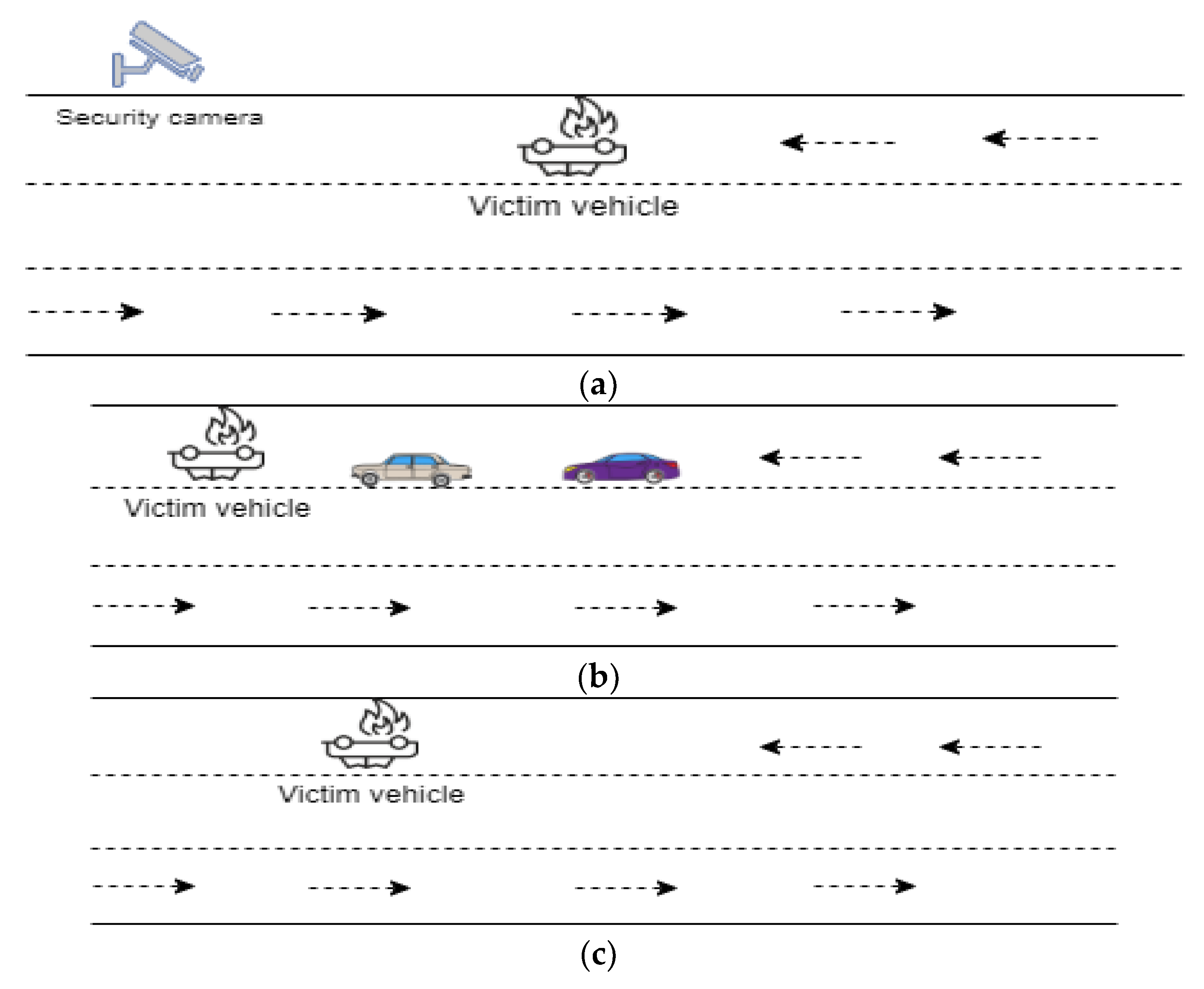
In the current highway mechanism of KSA, long distances roads are equipped with security cameras. These cameras are installed after a particular distance to monitor the roads’ vehicles and control the speed. While a passenger is traveling, there are three possibilities of accidents such as,
Case 1: The passenger is traveling on a long-distance highway, and an accident occurs, there is no other vehicle on the road, but there is a nearby security camera for monitoring road traffic as shown in
Figure 4a.
As mentioned above, SMOT has taken various steps in improving road safety; one of the leading steps is the installation of high-resolution security cameras on highways. These cameras can capture the vehicle image from all directions by 360-degree rotation. These cameras aim to monitor speed limit, red light crossing, excessive lane changing, the distance between vehicles, seat belt, and license plate recognition. These cameras have played a vital role in reducing traffic incidents, but new cases of accidents are still reported daily. In Case 1 as shown in
Figure 4a. The overall performance of the system will be evaluated based on the six parameter values as shown in
Table 4 and Equation (2):
where
. is the probability of success.
The probability of success is 1 which shows that the accident will be reported on time and the passenger will get all kinds of legal and medical help.
Case 2: The passenger is traveling on a long-distance highway, and an accident occurs, there is no security camera nearby, but there are other vehicles on the road.
In the second scenario as shown in
Figure 4b, the probability of obtaining timely aid depends on whether a vehicle traveling on the same route gives timely assistance or not. Because of legal concerns, some people are afraid to help in such instances. However, in the majority of situations where passers-by are unwilling to help until legal authorities arrive, they at least notify legal authorities promptly. The overall performance of the system, in this case, will be evaluated based on the six parameter values as shown in
Table 5.
Substituting the weight values of
Table 5 in Equation (2), we get the probability of success as shown in Equation (4):
Case 3: The passenger is traveling on a long-distance highway, and an accident occurs. There is no security camera or a vehicle on the road nearby.
The worst-case scenario is the third scenario as shown in
Figure 4c; in most situations, this scenario results in mortality since the victim is left on the road for an extended period without aid, and in most cases, massive blood loss is the cause of death. The only way of getting assistance, in this case, is if another local or legal vehicle passes along that route. Hence, the probability of first aid availability is almost less than 0.20 in this case.
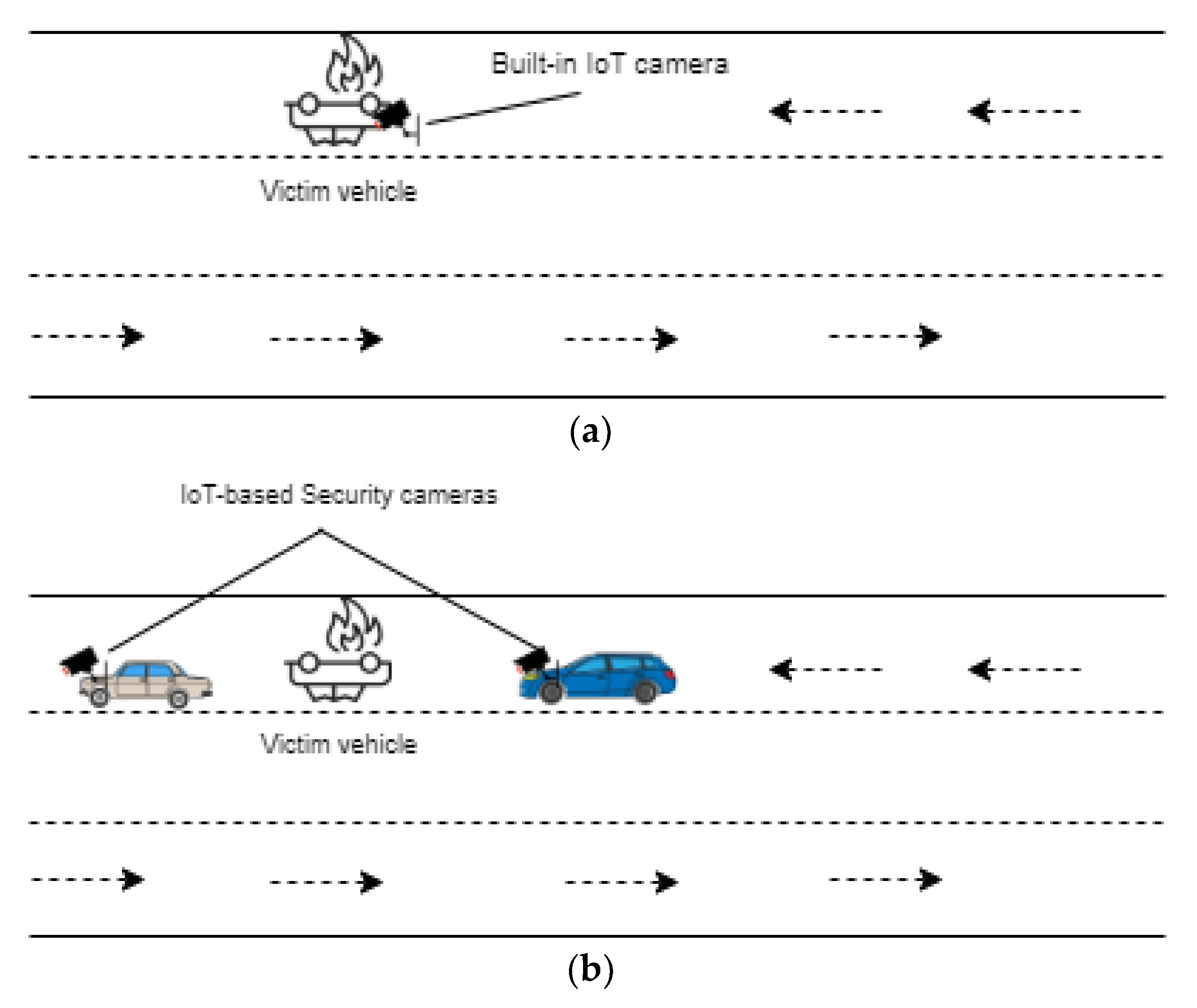
4.3. Proposed Passenger Safety Mechanism
Now we discuss the working of the proposed model where all the registered vehicles on the highway are equipped with front-back security cameras which fetch real-time passenger data and send it to the cloud through 5G. The image-processing scheme will analyze the vehicle images and raise alarm in case of an accident. This alarm will intimate TAs to take the required action. TAs will monitor real-time data of the vehicles for providing timely legal and medical help to the passengers traveling on the road. Below are the three possibilities of road crash incident.
Case 1: Vehicle is crashed but security camera is working and there is no other vehicle on the road.
In Case 1, if a vehicle is involved in an accident but the security camera is operational as shown in
Figure 5a. TAs will be informed of the incident based on the data obtained from the security camera installed in the victim’s vehicle. By sharing the footage of the situations, TAs will alert the local legal and medical authorities for assistance. When the local first-aid authorities are informed of the incident’s specifics, they will take appropriate action. The overall performance of the system will be evaluated based on the six parameter values as shown in
Table 6 and Equation (5).
In this instance, the chances of receiving timely assistance will be high, and the only reason for the delay might be the distance between the victim and the aiding authorities.
Case 2: Vehicle is badly crashed and IoT-enabled front-back cameras stop working but there are other vehicles on the road.
In this case, when a vehicle collides and the security camera stop working but there are other vehicles on the road as shown in
Figure 5b, the chances of receiving timely medical and legal assistance are increased. The reason for increased assistance is that not only will the passing-by vehicle notify local legal authorities, but TAs will also learn about the incident from the alarm sent by image-processing scheme after analyzing the data of other vehicles on the road. Thus the overall performance of the system will be evaluated based on the six parameter values as shown in
Table 7 and Equation (6).
Substituting the weight values of
Table 7 in Equation (2), we get the probability of success as shown in Equation (6):
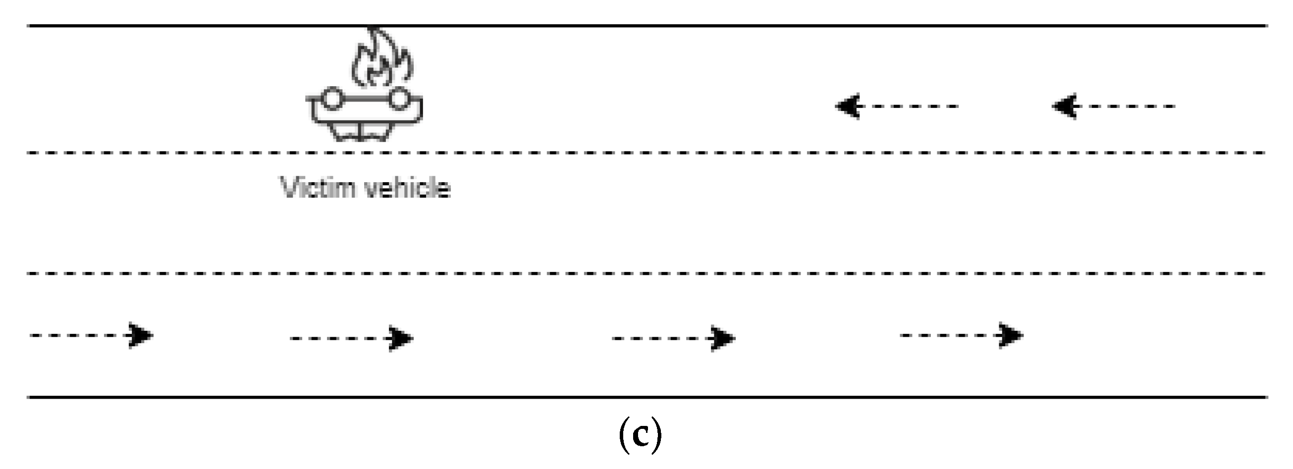
Case 3: Vehicle is badly crashed, and IoT-enabled front-back cameras stop working and there is no other vehicle on the road.
This is the worst scenario occurring on the road when the vehicle crashes along with security cameras and there is no helping body nearby as shown in
Figure 5c. The proposed model also assists in this scenario; the image-processing scheme monitoring vehicles’ data will notice that incoming data from a particular vehicle has ceased, signaling that the vehicle is likely in trouble and will generate alarm.
In such a circumstance, TAs will locate the victim vehicle’s last fetched data position and notify local authorities to approach that vehicle for assistance. Although the likelihood of timely assistance in this event is lower than in the other two scenarios, the victim will still receive assistance. The delay in this scenario might be attributable to two factors: first, the time it takes for the image-processing scheme to discover the absence of data, and second, the distance between supporting authorities and the victim. The overall performance of the system, in this case, will be evaluated based on the six parameter values as shown in
Table 8.
Substituting the weight values of
Table 8 in Equation (2), we get the probability of success as shown in Equation (7):
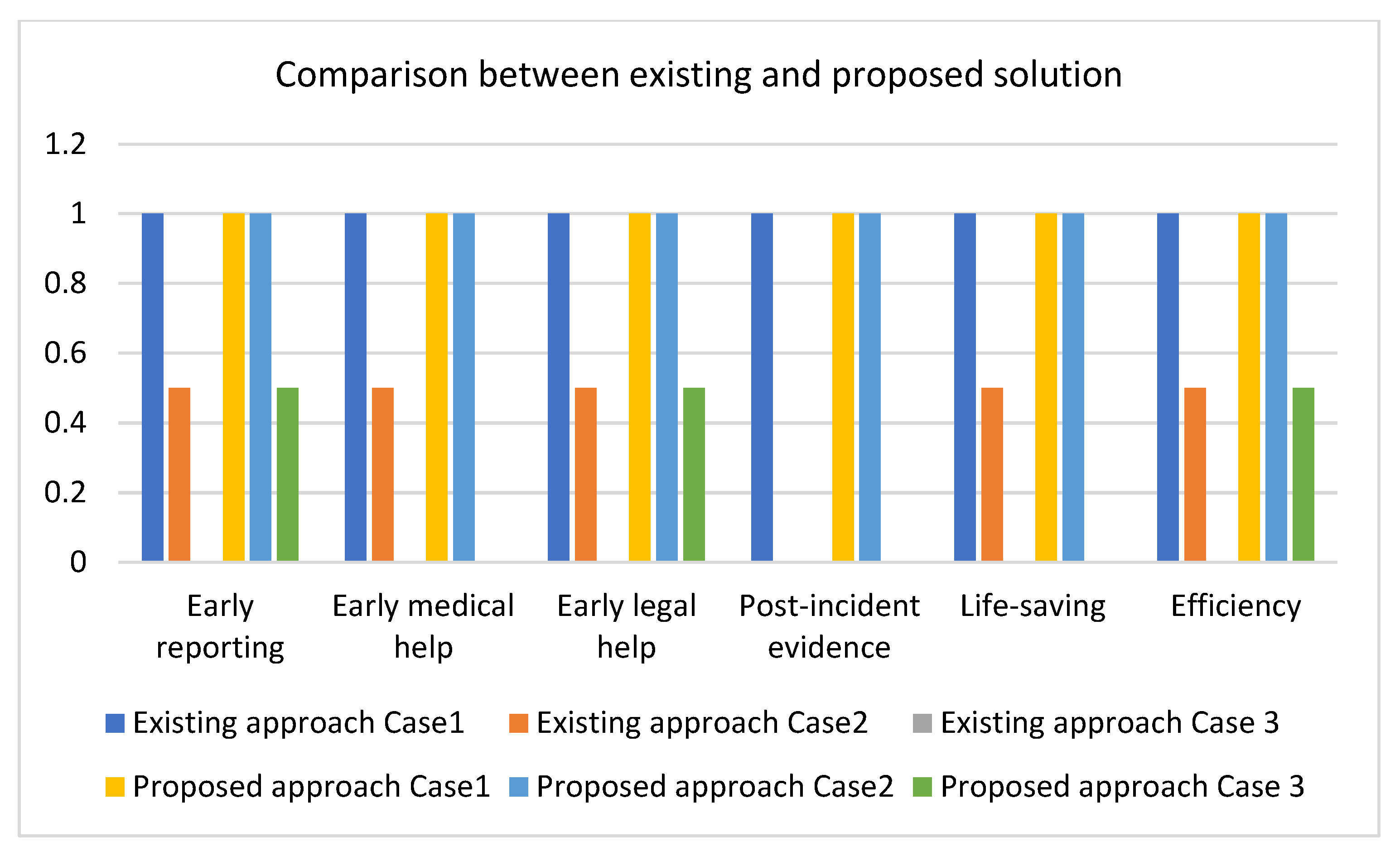
4.4. Comparison with the Existing Solution
Now we examine the likelihood of providing timely aid to the victim on Saudi highways in both the existing and proposed solutions as shown in
Figure 6. In all three situations outlined above, the possibility of giving timely aid to the victim on the highway is high in the case of the proposed model as compared to the present technique, as shown in
Figure 6. This shows that the proposed approach can contribute to reducing fatality statistics on Saudi highways by providing timely assistance to the passenger having an accident on these highways.
As shown in
Figure 6, the suggested technique provides greater post-crash assistance in all three scenarios, according to the data. On the x-axis, six parameters of evaluation are shown, and on the y-axis, the likelihood of success is represented. The suggested method outperforms the current solution in all three of the scenarios shown in
Figure 5, while the existing system outperforms only in Case 1 when there is a security camera on the road.
5. Limitations and Practical Implications
The results obtained from the case studies show that the proposed model provides passenger security on the highway in a better way. However, there are a few limitations of this study. Firstly, the proposed solution is expensive as it demands that every vehicle traveling on the highway must be equipped with front-back security cameras. Secondly, 5G is recommended in the proposed model for data transmission between IoT-based cameras and the cloud, while 5G is not implemented in all areas of KSA yet. Thirdly, CET has improved transportation and made it more intelligent than ever before, but they have also opened up new opportunities for adversaries and attackers. The proposed model, which is based on modern CET, may be vulnerable to a variety of security breaches. Furthermore, the use of these CET necessitates improved governance, infrastructure changes, additional time and expense, as well as transparency, supervision, and accountability.
This research can benefit SMOT in the future planning of their highways. To carry out the suggested strategy, multiple government agencies such as the law enforcement agency, the transportation ministry, and information technology must collaborate. The information technology department will expand CET, the law enforcement department will enact legislation governing vehicles traveling on long-distance highways, such as the use of IoT cameras in the car, and SMOT will use CET to store vehicle information, collect data, analyze it, and make decisions. Additionally, the suggested method would aid researchers in comprehending the significance of the current CET in enhancing passenger safety.
6. Conclusions and Future Work
Even though SMOT is working hard to improve road safety, RTAs are one of the leading causes of mortality in Saudi Arabia, particularly on long-distance highways. Accident statistics have been reduced in the last few years, but there is still space for further improvement. One of the causes of fatalities is the failure to provide prompt medical and legal assistance to passengers traveling on highways in an accident. This research has proposed a passenger safety model named RTSHPMP based on IoT, 5G, and Cloud to solve this problem. According to the proposed model, all the cars traveling on highways will be equipped with front-back IoT-based security cameras to collect passenger and surrounding information and send it to the cloud through 5G. An image-processing scheme will monitor the data of the cloud continuously and generate an alarm in the case of any unusual incident. After receiving the alarm, TAs will send an alert to ERH along with the video of that accident. Thus, the passenger will get the timely legal and medical help that will avoid fatalities. The proposed model was tested using a case study, and results show that the proposed model is better at improving passenger security on Saudi highways.
In the future, we will extend the evaluation part by evaluating this model through simulation. We will also add more characteristics to the proposed model by taking advantage of further CET.
Author Contributions
Conceptualization, N.J.; Data curation, M.H.; Formal analysis, M.H.; Funding acquisition, A.A.; Investigation, M.H. and A.A.; Methodology, M.H.; Project administration, N.J.; Resources, A.A.; Software, A.A.; Writing—original draft, M.H.; Writing—review & editing, N.J. All authors have read and agreed to the published version of the manuscript.
Funding
This work was funded by the Deanship of Scientific Research at Jouf University under grant No (DSR-2021-02-0323).
Institutional Review Board Statement
Not applicable.
Informed Consent Statement
Not applicable.
Data Availability Statement
Will be furnished on request.
Acknowledgments
This work was funded by the Deanship of Scientific Research at Jouf University under grant No (DSR-2021-02-0323).
Conflicts of Interest
The authors declare no conflict of interest.
References
- Aldagheiri, M. The role of the transport road network in the economic development of Saudi Arabia. WIT Trans. Built Environ. 2009, 107, 275–286. [Google Scholar] [CrossRef]
- Road Safety. Ministry of Transport. Available online: https://mot.gov.sa/en/Roads/Pages/SafetyOnRoad.aspx (accessed on 4 October 2021).
- Saudi Arabia Home to the World’s Longest Straight Road, Arab News. Available online: https://www.arabnews.com/node/1263776/offbeat (accessed on 19 August 2020).
- Al-Ahmadi, H.M.; Jamal, A.; Ahmed, T.; Rahman, M.T.; Reza, I.; Farooq, D. Calibrating the Highway Safety Manual Predictive Models for Multilane Rural Highway Segments in Saudi Arabia. Arab. J. Sci. Eng. 2021, 46, 11471–11485. [Google Scholar] [CrossRef]
- DeNicola, E.; Aburizaize, O.S.; Siddique, A.; Khwaja, H.; Carpenter, D.O. Road traffic injury as a major public health issue in the Kingdom of Saudi Arabia: A review. Front. Public Health 2016, 4, 215. [Google Scholar] [CrossRef] [PubMed]
- Al Junaibi, M.M.; Georgakis, P.; Mushatat, S. Examining the direct effect of the use of traffic safety technologies in Abu Dhabi highways on other traffic safety dimensions. J. Traffic Logist. Eng. 2017, 5, 1–9. [Google Scholar] [CrossRef][Green Version]
- Jadi, A.M. Implementing a Safe Travelling Technique to Avoid the Collision of Animals and Vehicles in Saudi Arabia. Int. J. Adv. Comput. Sci. Appl. 2019, 30–39. [Google Scholar] [CrossRef]
- Mansuri, F.A.; Al-Zalabani, A.H.; Zalat, M.M.; Qabshawi, R.I. Road safety and road traffic accidents in Saudi Arabia: A systematic review of existing evidence. Saudi Med. J. 2015, 36, 418. [Google Scholar] [CrossRef]
- AlSaeed, M.A.; Aljoher, A.M.; Althafar, A.K.; Alarifi, A.A.; Aljoher, A.M.; Nineaa, M.; Bougmiza, I. Road Traffic Accident: What Is Being Practiced on The Scene to RTA Casualties in Al-Ahsa City, Saudi Arabia? Egypt. J. Hosp. Med. 2018, 71, 2380–2386. [Google Scholar] [CrossRef][Green Version]
- Ahmed, S.; Mahmood, M.; Rizvi, S.A.H.; A Siddiqui, A.; Shahid, N.; A Akram, W.; Bano, S. Frequency and nature of road traffic injuries: Data of more than 10,000 patients from Ha’il, Saudi Arabia. Cureus 2019, 11, e3830. [Google Scholar] [CrossRef]
- Jabbar, R.; Shinoy, M.; Kharbeche, M.; Al-Khalifa, K.; Krichen, M.; Barkaoui, K. Urban traffic monitoring and modeling system: An iot solution for enhancing road safety. In Proceedings of the 2019 International Conference on Internet of Things, Embedded Systems and Communications (IINTEC), Tunis, Tunisia, 20–22 December 2019. [Google Scholar] [CrossRef]
- Taha, A.-E.M. An IoT architecture for assessing road safety in smart cities. Wirel. Commun. Mob. Comput. 2018, 2018, 8214989. [Google Scholar] [CrossRef]
- Vishal, D.; Afaque, H.S.; Bhardawaj, H.; Ramesh, T.K. IoT-driven road safety system. In Proceedings of the 2017 International Conference on Electrical, Electronics, Communication, Computer, and Optimization Techniques (ICEECCOT), Mysuru, India, 15–16 December 2017. [Google Scholar] [CrossRef]
- Ashokkumar, K.; Sam, B.; Arshadprabhu, R. Cloud based intelligent transport system. Procedia Comput. Sci. 2015, 50, 58–63. [Google Scholar] [CrossRef]
- Kumar, V.; Ahmad, M.; Kumari, A.; Kumari, S.; Khan, M.K. SEBAP: A secure and efficient biometric-assisted authentication protocol using ECC for vehicular cloud computing. Int. J. Commun. Syst. 2021, 34, e4103. [Google Scholar] [CrossRef]
- Almusaylim, Z.A.; Zaman, N.; Jung, L.T. Proposing a data privacy aware protocol for roadside accident video reporting service using 5G in Vehicular Cloud Networks Environment. In Proceedings of the 2018 4th International Conference on Computer and Information Sciences (ICCOINS), Kuala Lumpur, Malaysia, 13–14 August 2018. [Google Scholar] [CrossRef]
- Shrestha, K. 5G: The Fututre of Improved Road Safety and Autonomous Vehicles. Bachelor’s Thesis, Metropolia University of Applied Sciences, Vantaa, Finland, 2020. Available online: https://www.theseus.fi/bitstream/handle/10024/267942/Shrestha_Kshitiz.pdf?sequence=2 (accessed on 4 June 2021).
- Raza, N.; Jabbar, S.; Han, J.; Han, K. Social vehicle-to-everything (V2X) communication model for intelligent transportation systems based on 5G scenario. In Proceedings of the 2nd International Conference on Future Networks and Distributed Systems, Amman, Jordan, 26–27 June 2018. [Google Scholar]
- Saher System General Department of Traffic, Misstry of Interior. Retrieve on 28 September 2021. Available online: shorturl.at/vCST0 (accessed on 28 September 2021).
- Khalid, M.; Awais, M.; Singh, N.; Khan, S.; Raza, M.; Malik, Q.B.; Imran, M. Autonomous Transportation in Emergency Healthcare Services: Framework, Challenges, and Future Work. IEEE Internet Things Mag. 2021, 4, 28–33. [Google Scholar] [CrossRef]
- Tian, J.; Chin, A.; Yanikomeroglu, H. Connected and autonomous driving. IT Prof. 2018, 20, 31–34. [Google Scholar] [CrossRef]
- Humayun, M. Role of emerging IoT big data and cloud computing for real time application. Int. J. Adv. Comput. Sci. Appl. 2020, 11, 494–506. [Google Scholar] [CrossRef]
- Khan, N.A.; Jhanjhi, N.; Brohi, S.N.; Usmani, R.S.A.; Nayyar, A. Smart traffic monitoring system using unmanned aerial vehicles (UAVs). Comput. Commun. 2020, 157, 434–443. [Google Scholar] [CrossRef]
- Talib, M.S.; Hussin, B.; Hassan, A. Converging VANET with vehicular cloud networks to reduce the traffic congestions: A review. Int. J. Appl. Eng. Res. 2017, 12, 10646–10654. Available online: https://www.ripublication.com/ijaer17/ijaerv12n21_21.pdf (accessed on 27 September 2021).
- Xie, L.; Ding, Y.; Yang, H.; Wang, X. Blockchain-based secure and trustworthy Internet of Things in SDN-enabled 5G-VANETs. IEEE Access 2019, 7, 56656–56666. [Google Scholar] [CrossRef]
- Liu, J.; Wan, J.; Jia, D.; Zeng, B.; Li, D.; Hsu, C.-H.; Chen, H. High-efficiency urban traffic management in context-aware computing and 5G communication. IEEE Commun. Mag. 2017, 55, 34–40. [Google Scholar] [CrossRef]
- Elkin, D.; Vyatkin, V. IoT in traffic management: Review of Existing Methods of Road Traffic Regulation. In Proceedings of the Computer Science On-line Conference, Zlin, Czech Republic, 15 July 2020; Springer: Berlin/Heidelberg, Germany. [Google Scholar]
- Humayun, M.; Jhanjhi, N.; Hamid, B.; Ahmed, G. Emerging smart logistics and transportation using IoT and blockchain. IEEE Internet Things Mag. 2020, 3, 58–62. [Google Scholar] [CrossRef]
- Humayun, M.; Jhanjhi, N.Z.; Alamri, M.Z.; Khan, A. Smart Cities and Digital Governance. In Employing Recent Technologies for Improved Digital Governance; IGI Global: Hershey, PA, USA, 2020; pp. 87–106. Available online: https://www.igi-global.com/chapter/smart-cities-and-digital-governance/245977 (accessed on 21 September 2021).
- Ponnusamy, V.; Yichiet, A.; Jhanjhi, N.; Humayun, M.; Almufareh, M.F. IoT Wireless Intrusion Detection and Network Traffic Analysis. Comput. Syst. Sci. Eng. 2022, 40, 865–879. Available online: https://www.techscience.com/csse/v40n3/44569/pdf (accessed on 4 October 2021). [CrossRef]
- Vijayalakshmi, B.; Ramar, K.; Jhanjhi, N.; Verma, S.; Kaliappan, M.; Vijayalakshmi, K.; Vimal, S.; Kavita; Ghosh, U. An attention-based deep learning model for traffic flow prediction using spatiotemporal features towards sustainable smart city. Int. J. Commun. Syst. 2021, 34, e4609. [Google Scholar] [CrossRef]
- Shen, Y.; Lee, J.; Jeong, H.; Jeong, J.; Lee, E.; Du, D.H.C. SAINT+: Self-Adaptive Interactive Navigation Tool+ for Emergency Service Delivery Optimization. IEEE Trans. Intell. Transp. Syst. 2017, 19, 1038–1053. [Google Scholar] [CrossRef]
- Nguyen, V.-L.; Hwang, R.-H.; Lin, P.-C. Controllable Path Planning and Traffic Scheduling for Emergency Services in the Internet of Vehicles. IEEE Trans. Intell. Transp. Syst. 2021, 1–15. [Google Scholar] [CrossRef]
- Ministry of Health Saudi Arabia. MOH Statistics and Indicators. Retrieved on 21 October 2021. Available online: https://www.moh.gov.sa/en/Ministry/Statistics/Pages/Traffic-accidents.aspx (accessed on 21 October 2021).
- Eiza, M.H.; Ni, Q.; Shi, Q. Secure and privacy-aware cloud-assisted video reporting service in 5G-enabled vehicular networks. IEEE Trans. Veh. Technol. 2016, 65, 7868–7881. [Google Scholar] [CrossRef]
- Cheng, X.; Chen, C.; Zhang, W.; Yang, Y. 5G-enabled cooperative intelligent vehicular (5GenCIV) framework: When Benz meets Marconi. IEEE Intell. Syst. 2017, 32, 53–59. [Google Scholar] [CrossRef]
- Humayun, M. Industrial Revolution 5.0 and the Role of Cutting Edge Technologies. Int. J. Adv. Comput. Sci. Appl. 2021, 12, 605–615. [Google Scholar] [CrossRef]
- Lu, Z.; Wang, Q.; Qu, G.; Zhang, H.; Liu, Z. A blockchain-based privacy-preserving authentication scheme for vanets. IEEE Trans. Very Large Scale Integr. Syst. 2019, 27, 2792–2801. [Google Scholar] [CrossRef]
- Sakiz, F.; Sen, S. A survey of attacks and detection mechanisms on intelligent transportation systems: VANETs and IoV. Ad Hoc Netw. 2017, 61, 33–50. Available online: https://web.cs.hacettepe.edu.tr/~ssen/files/papers/AdhocNets17.pdf (accessed on 14 July 2021). [CrossRef]
- Rundmo, T.; Nordfjærn, T.; Iversen, H.H.; Oltedal, S.; Jørgensen, S.H. The role of risk perception and other risk-related judgements in transportation mode use. Saf. Sci. 2011, 49, 226–235. [Google Scholar] [CrossRef]
- Yuan, Y.; Wang, F.Y. Towards blockchain-based intelligent transportation systems. In Proceedings of the 2016 IEEE 19th International Conference on Intelligent Transportation Systems (ITSC), Rio de Janeiro, Brazil, 1–4 November 2016. [Google Scholar] [CrossRef]
| Publisher’s Note: MDPI stays neutral with regard to jurisdictional claims in published maps and institutional affiliations. |
© 2022 by the authors. Licensee MDPI, Basel, Switzerland. This article is an open access article distributed under the terms and conditions of the Creative Commons Attribution (CC BY) license (https://creativecommons.org/licenses/by/4.0/).


