Article

Migration and Diffusion of Surface Sediments in Bohai Bay: Evidence from Grain Size and Elements

1
State Environmental Protection Key Laboratory of Marine Ecosystem Restoration, Dalian 116023, China
2
National Marine Environmental Monitoring Center, Dalian 116023, China
3
College of Harbour, Coastal and Offshore Engineering, Hohai University, Nanjing 210098, China
4
Marine Academy of Zhejiang Province, Hangzhou 310012, China
5
Dalian Compass Ocean Engineering Consulting Corporation Ltd., Dalian 116023, China
*
Author to whom correspondence should be addressed.
Appl. Sci. 2022, 12(21), 10738; https://doi.org/10.3390/app122110738
Submission received: 9 September 2022 / Revised: 14 October 2022 / Accepted: 20 October 2022 / Published: 23 October 2022
(This article belongs to the Special Issue Sediment Transport)

Abstract

:
Grain size and element content of surface sediment from Bohai Bay were analyzed to study the sediment migration and diffusion based on grain size trend analysis (GSTA) and discriminant function (DF). The sediment in the southern, central and western part of Bohai Bay mainly originates from the Yellow River, while that in the northern part of Bohai Bay mainly originates from the Luanhe River. The influence boundary between the Yellow River and the Luanhe River is estimated to be at 38°50′ N. In both the southern and northern parts of Bohai Bay, sediment is transported into the bay under the influence of prevailing waves, strongest waves and tidal remnants, resulting in sediment accumulation in western Bohai Bay. The coastal sediment of Bohai Bay is generally in a state of offshore movement, which is consistent with the large-scale coastline retreat in past decades found by previous studies.

1. Introduction

Source, transport and accumulation of sediment in the ocean are components in the study of the “source-sink” process, and are also an important part of land-sea interaction research. Transportation of sediment in the ocean is the result of complex dynamic processes. Their flux and fate directly affect the evolution characteristics of seabed topography and are closely related to the stability of coast and service life of marine engineering, especially around Bohai Bay, where it is usually accompanied by intense marine development and human activities. Sediment transportation has always been one of the widely concerning oceanographic issues.
Bohai Bay is one of the three major bays in the Bohai Sea (Figure 1). Due to the discharges of three large rivers (Yellow River, Luanhe River and Haihe River), Bohai Bay has a rich source of sediment, and large deltas have developed along much of the bay’s shoreline. In recent years, the runoff and sediment input from the Yellow River have gradually decreased, due to the massive construction of dams, power stations, increased water consumption, climate change and other factors. Subsequently, the evolutionary state of the Yellow River underwater delta has changed from constructive to destructive [1]. Sediment eroding from the subaqueous Yellow River Delta (YRD) is causing the retreat of the adjacent coast [2] as well as shoaling offshore in southern and western Bohai Bay (Figure 1). These conditions reveal that sediment transport in Bohai Bay has changed significantly. Bohai Bay is famous for its well-developed harbor transportation and oil exploitation industries. There are several large ports and oil exploitation areas along the coast. Therefore, the sediment transport and the resulting siltation and erosion in Bohai Bay hold great scientific significance, not only to enhance research on the source and sink process of bay sediment, but also to protect transportation and oil exploitation in Bohai Bay.
Earlier work by Qin et al. [3], Han et al. [4] and Zhang et al. [5] from 1985 to 2015 provided a basis for the work described here, and an indication that sediment transport in Bohai Bay has changed significantly over the past 30 to 40 years. Detrital sediments from the Yellow River and Luanhe River can affect the central and eastern parts of the Bohai Sea [6]. About 88% of the Yellow River sediment is deposited on the front edge of the underwater delta [7], and there are three directions of diffusion: northeast, northwest and southeast [8]. Due to the existence of the shear front, the estuary sediment is confined to the shore side of the shear front and transported to the north and south with the current [9]. Sediment discharge from the Luan River is much smaller than that of the Yellow River, and most of it is deposited in the coastal area from the mouth of the Luanhe River west to Caofeidian (Figure 1). The sediment outside the Caofeidian Sandbar is transported from sea to land, which is believed to be related to the coastal sediment transport caused by winds in the NW, SW and SE directions [10]. The sediment distribution of the Bohai Sea is consistent with the circulation trend [11]. However, the study areas of earlier studies are all local parts of Bohai Bay, such as the Yellow River estuary waters and Caofeidian waters. Therefore, a clear understanding of sediment transport in Bohai Bay overall is still lacking.
This study clarifies the sediment transport trend and its dynamic mechanism in Bohai Bay through a large-scale investigation on the grain size and element content of surface sediment. The results can provide guidance and reference for coastal disaster prevention and safety.

2. Materials and Methods
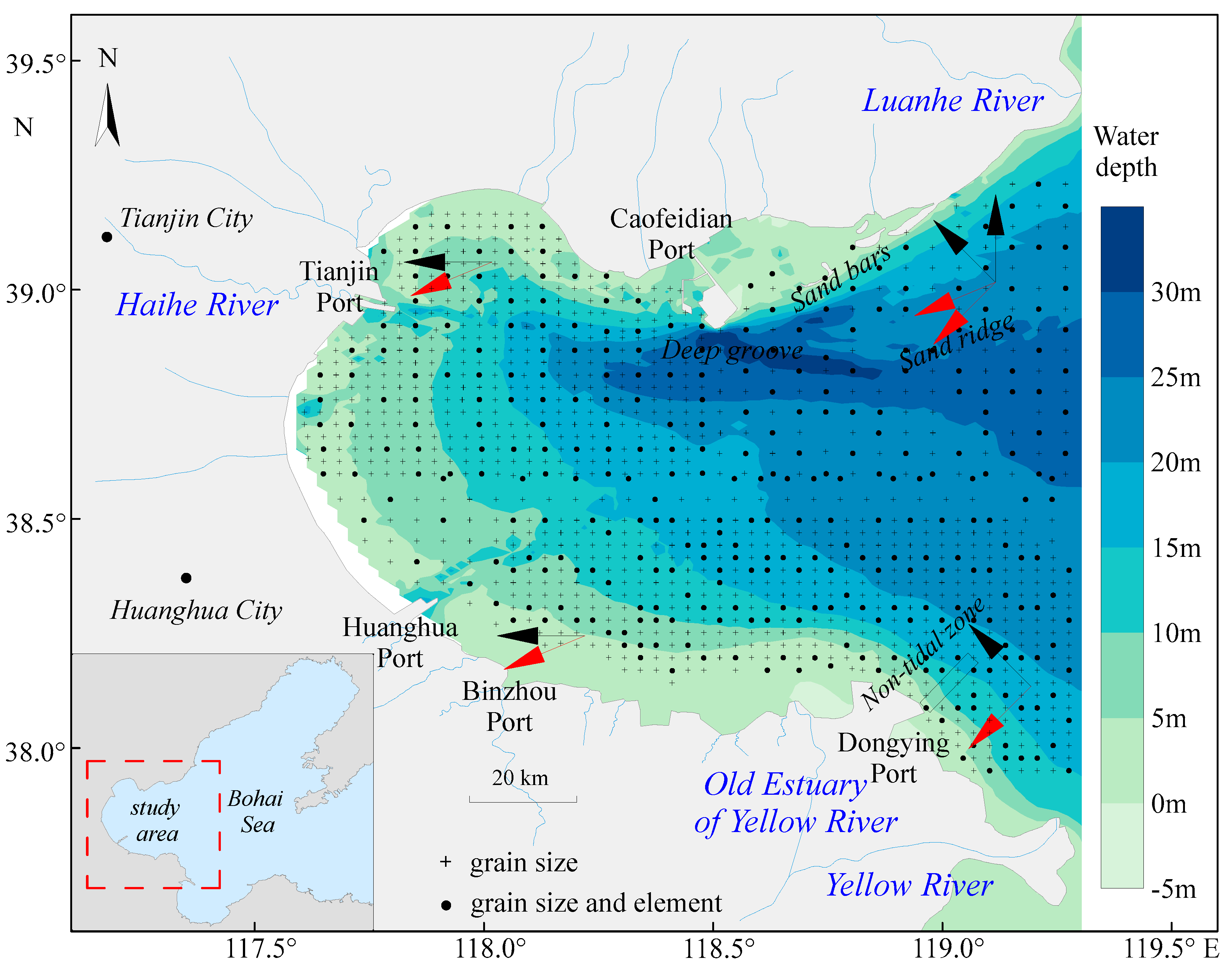
2.1. Study Area

Bohai Bay is located in the west of the Bohai Sea (Figure 1), and is one of three bays of the Bohai Sea. The submarine slope is smaller in the west of Bohai Bay, but larger in the northeast of Bohai Bay and the Yellow River Estuary. The maximum water depth of the Caofeidian Deep Trough can reach 40 m. The three large rivers—the Yellow River, Luanhe River, and Hai River—flow into Bohai Bay. The Yellow River is world famous for its large sediment discharge, with an average annual sediment discharge of about 7.45 × 10⁸ t. This sediment originates mainly in the Loess Plateau. The average annual sediment discharge of the Luanhe River is about 0.21 × 10⁸ t, mainly stemming from Yansha granite and metamorphic rock [12]. The average annual sediment discharge of the Haihe River is only about 0.06 × 10⁸ t, much smaller than that of the Yellow River and Luanhe River. Some tributaries in the upper reaches of the Haihe River traverse or originate from the Taihang Mountains [13]. With the Yellow River being the primary contributor to the sediment of Bohai Bay, multiple deltas have accumulated along the coast of Bohai Bay.
The sediment types in central Bohai Bay are silt and muddy silt. The sediment types from coast to sea are silty sand and sandy silt in south Bohai Bay, and sand and sandy silt in north Bohai Bay. The sediment type of the underwater sand ridge is silty sand. The suspended sediment concentration (SSC) is high in south Bohai Bay (along the delta coast) and low in north Bohai Bay [2]. The average SSC along the delta exceeded 20 mg L−1 and was 200–3000 mg L−1 higher in winter than in summer [14].

2.2. Sample Collection and Testing

1154 surface sediment samples (Figure 1) were collected in Bohai Bay using a grab (Shuguang HNM12 0.05 m2, CHN) in July 2010. Sediment was sampled at 3 km intervals in almost the entire bay, but at 5 km intervals in the northeastern part of the bay. The upper 2 cm of the sediment was collected and sealed for storage at room temperature. Sediment samples were tested in the Key Laboratory of Submarine Geosciences and Prospecting Techniques, Ministry of Education, Ocean University of China. Grain size tests were performed on samples from all stations, and geochemical tests were performed on samples from every other station. Data from several stations were excluded due to missing samples or poor data quality.
The grain size of 1154 samples was measured by a laser diffraction grain size analyzer (Malvern Mastersizer 2000, Malvern, UK). After sample pre-treatment and preparation [15], the particle size was tested with a Malvern Mastersizer 2000. The relative error of repeated measurement was less than 3%. The grain size parameters were calculated using a moment method [16].
The geochemical composition of 330 samples was measured by a SPECTRO XEPOS energy-dispersive X-ray fluorescence spectrometer (XRF, SPECTRO Analytical Instruments, Kleve, Germany). After sample pre-treatment and preparation [15], the content of the element was tested with the XRF. The relative error of repeated measurement was less than 2%.

2.3. Grain Size Trend Analysis (GSTA)

Sediment trend study based on grain size parameters was carried out using a GSTA Fortran program [17] based on a two-dimensional model proposed by [18]. The model is based on the comparison of the three statistical grainsize parameters (mean size, sorting and skewness) of sediment samples [19]. The combination of three parameters will result in eight possible grain size trends, but only two trends are reasonable [20]. That is, the sediment should become: (i) finer, better sorted, more negatively skewed (case: FB-); (ii) coarser grain size, better sorted, and more positively skewed (case: CB+) in the transport direction. The calculation process of GSTA is as follows. First, a critical distance (Dcr) is defined, which is generally the length of the maximum sampling interval or the diagonal length of the sampling grid. A station whose distance from the computing station is less than Dcr is identified as a neighbor. Judge one by one whether the two trends (FB- and CB+) exist between the computing site and its neighbors. If the result is yes, a length 1 trend vector from the computing site to the neighboring site is generated. The trend vector of any site is the sum of all trend vectors of the site with its neighbors:
R ( x , y ) = b 1 n r ( x , y )
In order to eliminate “noise”, GSTA smooths the trend vector by calculating the average vector of the site and its neighbors. The mathematical transformation formula for smoothing is as follows:
R m ( x , y ) = 1 1 + k [ R ( x , y ) + 1 k R j ( x , y ) ]
Finally, a map of the remaining vectors of all stations is drawn. The GSTA model is considered affected by two main sources of uncertainty: (i) different feature distances and (ii) edge effects of edge sampling points [18,21].

2.4. Discriminant Function (DF) Analysis

Sediment trend study based on the element diffusion index was carried out using the discriminant function (DF) method [22]. Significant differences were identified in the element contents of materials from the Yellow River and Luanhe River according to the earlier work of other researchers (Table 1). The main stream of the Yellow River flows through the Loess Plateau, and the sediment carried by the Yellow River is characterized by a high calcium (Ca) content [23]. The Ca content in the material from the Luanhe River is much lower than that of the Yellow River. Therefore, Ca can be used to analyze the sediment contribution of the rivers, which can also be used to study the transport and diffusion of river material. The element aluminum (Al) was used to eliminate the controlling effect of grain size. DF is used to judge the similarity between two samples, and the calculation formula is as follows:
DF = |(Ca/Al)sample/(Ca/Al)river − 1|
Therefore, the DF index indicated the proximity of a sample to some source. The closer the DF index was to 0, the closer the composition of sediment was to the source. As the annual sediment transport of the Haihe River is much smaller than that of the Yellow River and Luanhe River, the Yellow River and Luanhe River were selected to calculate the DF.

3. Results

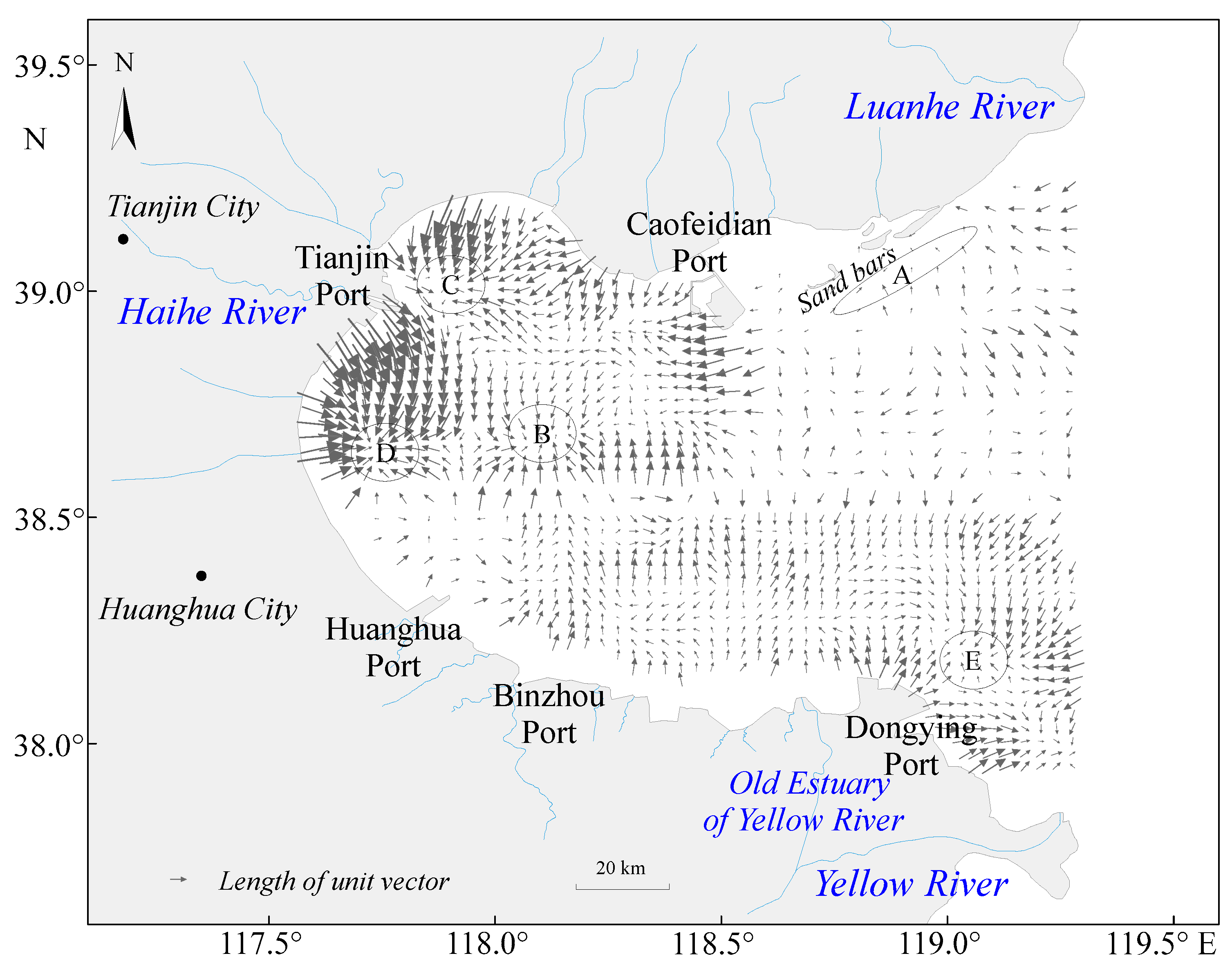
3.1. Grain Size Trends

Since the sampling interval in this study is relatively regular, the critical distance is determined to be no shorter than the diagonal distance of the sampling grid and no longer than twice the distance of the sampling grid. Finally, we decided to use Dcr = 0.08 for grain size trend analysis. Before running GSTA, the data was checked through scatter plot in order to eliminate obvious outliers. The distribution of remaining vectors is shown in Figure 2. In northeast Bohai Bay, sediment from the modern Luanhe River migrated in the southwest direction and gathered at a sandbank and underwater bank slope (Area A). In the Caofeidian Deep Trough, sediment migrated from east to west. In northwest Bohai Bay, sediment was moved from the coast and sunk with materials from the Deep Trough (Area C). In southwest Bohai Bay, sediment was removed from the coast and sunk in the outer sea area of the Ziyaxin Estuary (Area D). In southern Bohai Bay, offshore sediment transportation occurred on all coasts, but differences in the direction of sediment transport were evident when compared with the two sides of the Old Yellow River Estuary. In the sea area to the west of the Old Yellow River Estuary, the offshore sediment moved westward, crossed the north side of Huanghua Port, migrated toward the northwest, and converged in the middle of Bohai Bay (Area B). East of the Old Yellow River Estuary, the offshore sediment migrated to the southeast and converged northeast of Dongying Port (Area E).

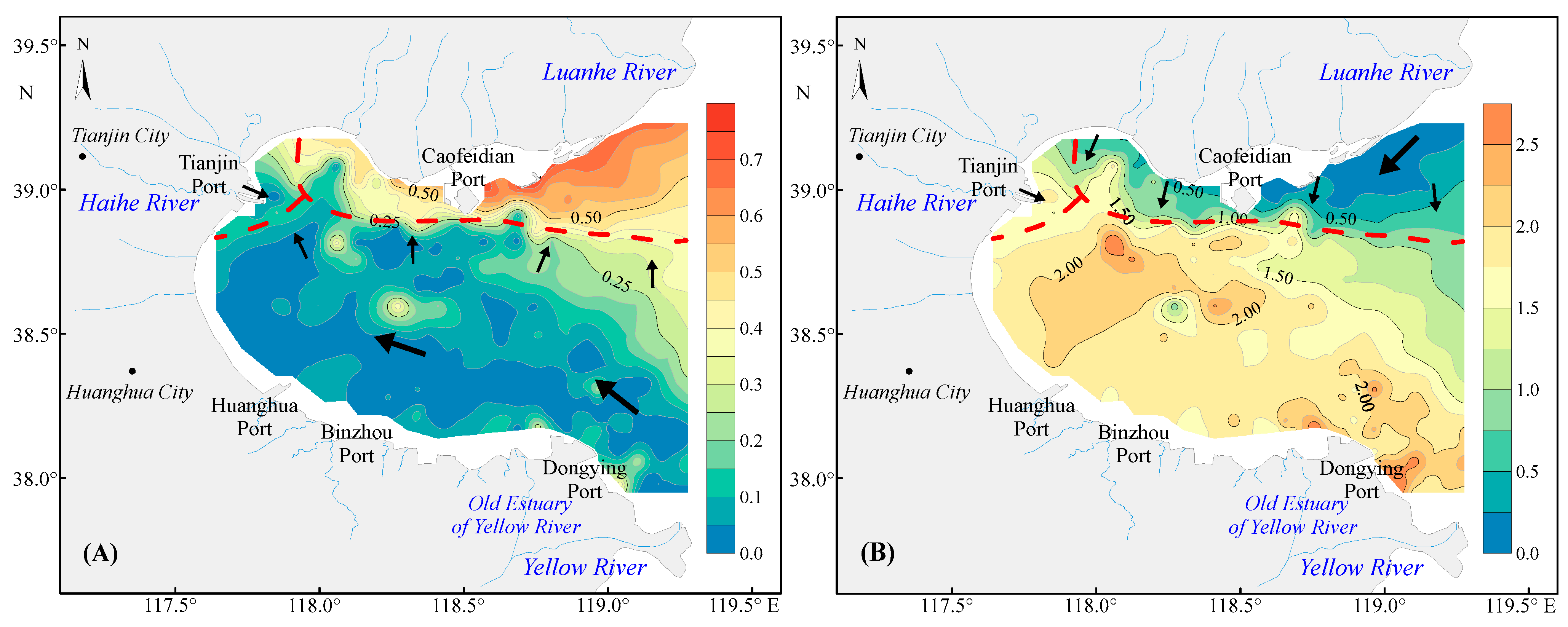
3.2. Distribution of Discriminant Function Indicator

Figure 3A illustrates the distribution of the Ca/Al discriminant function between sediment samples and the Yellow River materials (DFYR). The DFYR of most sea areas in southwest Bohai Bay was less than 0.5, which was close to the provenance of the Yellow River. The DFYR in the northeast and northern coastal waters of Bohai Bay were greater than 0.5. The distribution of the Ca/Al discriminant function between sediment samples and Luanhe River materials (DFLR) is shown in Figure 3B. The DFLR in the northeast and north coast of Bohai Bay was less than 0.5 and was at its smallest in the lagoons and the modern Luanhe Estuary. The data indicated that the sample was close to the material from Luanhe River. In most areas of southwest Bohai Bay, the DFLR was larger than 0.5.

4. Discussion

4.1. River Contribution and Sediment Diffusion

The DFYR was less than 0.5 in southern, middle and western Bohai Bay, which indicates that materials from the Yellow River dominated almost the entire bay. The DFLR in northeast Bohai Bay was less than 0.5, which indicates that material from the Luanhe River dominated only in northeast Bohai Bay. The DFLR in the tidal sand ridge outside Caofeidian was also small, serving as the evidence that its material came from the Luanhe River. The sediment in south and west Bohai Bay had a small DFYR with Yellow River provenance, which may have been related to the accumulation history of the Yellow River Delta. In the past, the Yellow River frequently changed its course to the sea. The area from the north bank of Bohai Bay to Tianjin, Huanghua, Binzhou, Kenli and Lijin was once an estuary of the Yellow River [26,27]. Currently, the west bank and south bank of Bohai Bay are deltas formed by materials from the Yellow River.
The DFYR distribution showed that the influence of the Yellow River materials gradually weakened from southwest to northeast, an indicator for the dispersion process of the material from the Yellow River as it was transported from the Yellow River Delta to its surrounding areas. The DFLR distribution showed that the influence of Luanhe River material gradually weakened from northeast to southwest, an indicator for the dispersion process of Luanhe River material as it was transported from the Luanhe River Delta to the southwest. Thus, the results of DF and GSTA are unified. Areas C and D in the western part of Bohai Bay (Figure 2) are influenced by mixed material sources from different rivers.
The sediment transport trends derived from GSTA and DF analyses in this study are consistent with the results obtained from geochemical analyses [5], grain size [28] and remote sensing inversion of suspended sediment [29,30].
Approximate influence range of different river sources is shown in Figure 3 and is generally consistent with the previous research [3,4,5]. Zhang et al. [5] gave the location of the influence boundary between the Yellow River and Luanhe River (38°42′ N). However, this study indicates that the influence of the Yellow River source is still underestimated, and the influence boundary between the Yellow River and Luanhe River is estimated to be at 38°50′ N.
The sediment diffusion details of the local sea area were finely described in this study. For example, although we neglected the source of the Haihe River in the discriminant function, the effect boundary between the Haihe River and the Yellow River can still be found from the map. Figure 3 shows that the influence of the Haihe River source is limited to the west of 118° E.

4.2. Coastal Erosion and Shoreline Retreat

The distribution of grain size trend vectors (Figure 2) indicates that sediment is transported from the shore to the sea in most coastal areas of Bohai Bay, implying that coastal erosion is currently an important source of sediment in Bohai Bay. Earlier studies showed that the submerged delta of the Yellow River [1] and the upper part of the submerged shore slope of the delta [31] have become destructive, and the shoreline of the Diaokou River (old Yellow River channel) has retreated severely towards land [32]. The sediment in the southern part of Bohai Bay has a very high content of sand components, while the clay and chalk components, which are easily carried away, have been almost eroded away [33]. Overall, this study shows that the coastal sediments of Bohai Bay are generally in a state of offshore movement, which is consistent with the large-scale coastline retreat [34] in past decades.
The Yellow River is known for its large sediment discharge, carries a large amount of sediment to the sea every year, causing the delta plain to gradually expand [27]. However, in recent decades, the Yellow River has discharged significantly less runoff and sediment [35,36]. The main reason for the retreat of the shoreline is that the Yellow River supplies less sediment than is being carried away [28]. This also leads to the fact that material eroded from the shore is another important source of sediment in Bohai Bay, in addition to the rivers.

4.3. Relationship between Sediment Transport and Ocean Dynamics

Waves are the main driving force for sediment transport in coastal waters. In the process of wave propagation to the coast, waves will break and form a coastal flow when the wave orthogonal and the coastline have a certain intersection angle, resulting in coastal sediment transport [34]. In the northern part of Bohai Bay, waves usually propagate from S–SE and the strongest waves mainly propagate from ENE–NE (Figure 1), resulting in westward transport of coastal materials from the modern Luanhe River and the ancient Luanhe River delta. In the southern part of Bohai Bay, waves usually propagate from NE–SE and the strongest waves mainly propagate from the NE (Figure 1), resulting in westward transport of coastal material from the Yellow River estuary and delta. Since the wave direction is almost perpendicular to the shoreline (Figure 1), waves disperse in the western part of Bohai Bay, leading to insignificant sediment transport along the coast (Figure 2).
Another important role of waves is to re-suspend sediment from the sea floor, as sediment can move with seawater only once it enters the water column. Sediment transport pattern in the Bohai Sea is seasonally variable and has been described as “stored in summer and transported in winter” [37]. Early studies have shown that the amount of suspended sediment along the Yellow River Delta is tens or even hundreds of times higher in winter than in summer, as strong winds and waves occur much more often in winter than in summer [14,38]. The sediment is re-suspended under wave disturbance and is constantly carried away by tidal currents into Bohai Bay when seawater flows to the northwest and into Laizhou Bay when seawater flows to the southeast.
Tidal currents also play an important role in sediment transport. Both in the northern [39] and southern [40] parts of Bohai Bay, the residual flow is westward, which leads to the transport of discharged material from the Yellow River estuary and the Luanhe River estuary to the western part of Bohai Bay. Figure 3 clearly indicates that the sediment in the wide area from the Yellow River estuary westward to the west coast of the bay has great similarity with the Yellow River source, and the sediment in the wide area from the Luanhe River estuary westward to the west coast of the bay has great similarity with the Luanhe River source. In addition, the circulation in Bohai Bay is in approximately the same direction as the residual flow (Figure 1), resulting in an environment conducive to sediment sinking formed by the circulation centers in the middle of the northwest of Bohai Bay and the middle of the southwest of Bohai Bay.

4.4. Impact of Sediment Transport on Offshore Oil Extraction

The oil exploration and exploitation industry is well developed in Bohai Bay, and numerous offshore platforms have been built. This study shows that the sediment in the south coast of Bohai Bay are strongly moved away from the shoreline (Figure 2), leading to changes in the seafloor, which poses a threat to the offshore platforms in the nearby Chengdao Oilfield and Chengbei Oilfield. The high-intensity erosion may adversely affect the stability of the offshore platform pile foundations, so it is necessary to monitor the dynamics of seafloor erosion and siltation.

5. Conclusions

Based on the analysis of the grain size and geochemical characteristics of the surface sediment in the Bohai Bay, this paper studied the provenance contribution of rivers, sediment migration and diffusion, and discussed their relationship with ocean dynamics. The main conclusions are as follows:
1
The results of grain size trend analysis showed that coastal sediment in Bohai Bay is generally removed from the coast, which is consistent with the widely observed shore retreat.
2
Discriminant function (DF) index based on Ca/Al can indicate the sediment contribution of the Yellow River and Luanhe River to Bohai Bay. Materials from the Yellow River dominated southern, western and central Bohai Bay, while materials from the Luanhe River dominated northeast Bohai Bay. The DF analysis indicated that the dominance of the Yellow River source was greater than previously thought, and the influence boundary between the Yellow River and Luanhe River is estimated to be at 38°50′ N. The influence of the Haihe River source is limited to the west of 118° E.
3
With the diversion of the Yellow River channel and the reduction of material feed into the sea, sediment transport in Bohai Bay is now controlled mainly by marine dynamic processes. In both south and north Bohai Bay, sediment was transported into the Bay under the influence of constant wave directions, strongest wave directions and tidal residual currents. The central sea area and the underwater bank slope along the west coast of Bohai Bay have become the main sink areas of sediment. The coast has become an important source of sediment in Bohai Bay, and the source is higher up to include the coast itself.

Author Contributions

Conceptualization, B.Z.; methodology, L.Z. and P.W.; formal analysis, B.Z.; investigation, B.Z., P.Z. and J.Y.; writing—original draft preparation, B.Z. and L.Z.; writing—review and editing, L.Z., P.W. and Y.Y.; visualization, J.Y.; supervision, Y.Y.; data curation, X.L. and S.Y.; and project administration, X.L. and S.Y. All authors have read and agreed to the published version of the manuscript.

Funding

This research received funding from the Foundation of State Environmental Protection Key Laboratory of Marine Ecosystem Restoration (No. 202106) and the Doctoral Scientific Research Foundation of Liaoning Province (No. 2021-BS-300).

Institutional Review Board Statement

Not applicable.

Informed Consent Statement

Not applicable.

Data Availability Statement

Data sharing not applicable.

Acknowledgments

The authors would like to thank the editors and reviewers for constructive suggestions and comments that helped improve the quality of the article.

Conflicts of Interest

The authors declare no conflict of interest.

References

  1. Wu, X.; Bi, N.; Xu, J.; Nittrouer, J.A.; Yang, Z.; Saito, Y.; Wang, H. Stepwise morphological evolution of the active Yellow River (Huanghe) delta lobe (1976–2013): Dominant roles of riverine discharge and sediment grain size. Geomorphology 2017, 292, 115–127. [Google Scholar] [CrossRef]
  2. Li, J.; Kang, H.; Wang, H.; Pei, Y. Modern geological action and discussion of influence facters on the west coast of Bohai Bay, China. Geol. Surv. Res. 2007, 30, 295–301. [Google Scholar]
  3. Qin, Y.; Zhao, Y.; Zhao, S. Geology of the Bohai Sea; Science Press: Beijing, China, 1985. [Google Scholar]
  4. Han, Z.; Zhang, J.; Zou, H.; Yi, W.; Li, M. Characteristics and provenance of clay mineral assemblage of sediments from the northern part of the Bohai Bay. Period. Ocean Univ. China 2011, 41, 95–102. [Google Scholar]
  5. Zhang, A.; Liu, M.; Liao, Y.; Zhang, Y.; Fan, D. The sedimentary geochemical trace of the Yellow River sediments diffusion in the Bohai Bay. Adv. Mar. Sci. 2015, 33, 246–256. [Google Scholar]
  6. Qin, Y.; Mei, X.; Jiang, X.; Luan, X.; Zhou, L.; Zhu, X. Sediment provenance and tidal current-driven recycling of Yellow River detritus in the Bohai Sea, China. Mar. Geol. 2021, 436, 106473. [Google Scholar] [CrossRef]
  7. Li, G.; Yue, S.; Zhao, D.; Sun, Y. Rapid deposition and dynamic processes in the modern Yellow River Mouth. Mar. Geol. Quat. Geol. 2004, 24, 29–36. [Google Scholar]
  8. Li, G.; Tang, Z.; Yue, S.; Zhuang, K.; Wei, H. Sedimentation in the shear front off the Yellow River mouth. Cont. Shelf Res. 2001, 21, 607–625. [Google Scholar] [CrossRef]
  9. Wang, H.; Yang, Z.; Bi, N. 3-Dsimulation of the suspended sediment transport in the Yellow River mouth I: Shear front off the Yellow River mouth. J. Sediment Res. 2006, 2, 1–9. [Google Scholar]
  10. Jia, Y.; Ke, X.; Xu, Y.; Wang, Y. Sedimentary transport trends of within a sand bar/lagoon system in the Bohai Sea. Mar. Sci. 1999, 3, 56–59. [Google Scholar]
  11. Zhao, B.; Zhuang, G.; Cao, D.; Lei, F. Circulation, tidal residual currents and their effects on the sedimentations in the Bohai Sea. Oceanol. Limnol. Sin. 1995, 26, 466–473. [Google Scholar]
  12. Zhang, Y.; Li, F. The characteristics of material component and the material resources in Huanghe (yellow) River, Luanhe River. Mar. Sci. 1983, 7, 15–18. [Google Scholar]
  13. Wang, Y. Analysis of Sediment Characteristics in the Tail Section of Haihe River and Compared with the Tail Section of Yellow River. Master’s Thesis, Ludong University, Yantai, China, 2017. [Google Scholar]
  14. Yang, Z.; Ji, Y.; Bi, N.; Lei, K.; Wang, H. Sediment transport off the Huanghe (Yellow River) delta and in the adjacent Bohai Sea in winter and seasonal comparison. Estuar. Coast. Shelf Sci. 2011, 93, 173–181. [Google Scholar] [CrossRef]
  15. Wang, P.; Zhang, L.; Lin, X.; Yan, J.; Zhang, P.; Zhao, B.; Zhang, C.; Yu, Y. Spatial distribution, control factors and sources of heavy metal in the surface sediments of Fudu Estuary waters, East Liaodong Bay, China. Mar. Pollut. Bull. 2020, 156, 111279. [Google Scholar] [CrossRef] [PubMed]
  16. Mcmanus, J. Grain size determination and interpretation. In Techniques in Sedimentology; Tucker, M.E., Ed.; Blackwell Scientific Publications: Hoboken, NJ, USA, 1988. [Google Scholar]
  17. Gao, S. A Fortran program for grain-size trend analysis to define net sediment transport pathways. Comput. Geosci. 1996, 22, 449–452. [Google Scholar] [CrossRef]
  18. Gao, S.; Collins, M.B. Analysis of grain size trends, for defining sediment transport pathways in marine environments. J. Coast. Res. 1994, 10, 70–78. [Google Scholar]
  19. McLaren, P. An interpretation of trends in grain size measures. J. Sediment. Petrol. 1981, 51, 611–624. [Google Scholar]
  20. McLaren, P.; Bowles, D. The effects of sediment transport on grain-size distributions. J. Sediment. Petrol. 1985, 55, 457–470. [Google Scholar]
  21. Poizot, E.; Méar, Y.; Biscara, L. Sediment Trend Analysis through the variation of granulometric parameters: A review of theories and applications. Earth-Sci. Rev. 2008, 86, 15–41. [Google Scholar] [CrossRef]
  22. Lan, X.; Zhang, X.; Zhao, G.; Zhang, Z. REE distributions and provenance discrimination of sediments from South Yellow Sea. Geochimica 2009, 38, 123–132. [Google Scholar]
  23. Yang, Z.; Wang, Z.; Ju, J.; Zheng, A. Study on carbonates from the coastal zone of the Yellow River Delta and adjacent Bohai Gulf. J. Ocean Univ. Qingdao 1989, 19, 91–99. [Google Scholar]
  24. Zhao, Y.; Yan, M. Geochemistry of China’s Shallow Sea Sediments; Science Press: Beijing, China, 1994. [Google Scholar]
  25. Liu, J. Material Compositions of Sediments in the Bohai Sea mud Area during the Holocene and Their Environmental Implications. Ph.D. Thesis, Chinese Academy of Sciences, Qingdao, China, 2007. [Google Scholar]
  26. Qiao, S.; Shi, X.; Saito, Y.; Li, X.; Yu, Y.; Bai, Y.; Liu, Y.; Wang, K.; Yang, G. Sedimentary records of natural and artificial Huanghe (Yellow River) channel shifts during the Holocene in the southern Bohai Sea. Cont. Shelf Res. 2011, 31, 1336–1342. [Google Scholar] [CrossRef]
  27. Xue, C. Historical changes in the Yellow River delta, China. Mar. Geol. 1993, 113, 321–330. [Google Scholar] [CrossRef]
  28. Yuan, P.; Bi, N.; Wu, X.; Zhang, Y.; Wang, H. Surface sediments at the subaqueous Yellow River Delta: Classification and distribution. Mar. Geol. Quat. Geol. 2016, 36, 49–57. [Google Scholar]
  29. Sun, S.; Xu, J.; Li, G.; Liu, X.; Qiao, L.; Zhou, S. Analysis of suspended sediments concentration in the Bohai Bay in winter based on remote sensing. Oceanol. Limnol. Sin. 2020, 51, 258–264. [Google Scholar]
  30. Liu, X.; Qiao, L.; Zhong, Y.; Wan, X.; Xue, W.; Liu, P. Pathways of suspended sediments transported from the Yellow River mouth to the Bohai Sea and Yellow Sea. Estuar. Coast. Shelf Sci. 2020, 236, 106639. [Google Scholar] [CrossRef]
  31. Wu, S.; Shen, X.; Zang, Q.; Zhang, Q.; Li, P.; Zhong, D.; Huang, Y. Preliminary study on the changes of sediment erosion and deposition in the Wuhaozhuang area of the Yellow River Delta. Ocean Dev. Manag. 1991, 8, 57–63. [Google Scholar]
  32. Wu, X.; Fan, Y.; Wang, H.; Bi, N.; Xu, C.; Zhang, Y.; Liu, J.; Lu, T. Evolution of abandoned deltaic river channel—A case from the Diaokou channel of the Yellow River. Mar. Geol. Quat. Geol. 2021, 41, 22–29. [Google Scholar]
  33. Zhang, L.; Hu, R.; Zhu, L.; Zhao, G.; Zhong, W. Characteristics of detrital minerals in Bohai Bay and their implications for provenance and sedimentary dynamical environment. Period. Ocean Univ. China 2019, 49, 60–70. [Google Scholar]
  34. Mi, B.; Yan, J.; Zhuang, L.; Luan, Z. The topographical and morphological features of modern Yellow River mouth area and their relation to erosional/depositional processes. Mar. Geol. Quat. Geol. 2010, 30, 31–38. [Google Scholar] [CrossRef]
  35. Wu, X.; Wang, H.; Bi, N.; Saito, Y.; Xu, J.; Zhang, Y.; Lu, T.; Cong, S.; Yang, Z. Climate and human battle for dominance over the Yellow River’s sediment discharge: From the Mid-Holocene to the Anthropocene. Mar. Geol. 2020, 425, 106188. [Google Scholar] [CrossRef]
  36. Wu, X.; Wang, H.; Bi, N.; Xu, J.; Nittrouer, J.A.; Yang, Z.; Lu, T.; Li, P. Impact of Artificial Floods on the Quantity and Grain Size of River-Borne Sediment: A Case Study of a Dam Regulation Scheme in the Yellow River Catchment. Water Res. 2021, 57, e2021W–e29581W. [Google Scholar] [CrossRef]
  37. Ren, M.; Shi, Y. Sediment discharge of the Yellow River (China) and its effect on the sedimentation of the Bohai and the Yellow Sea. Cont. Shelf Res. 1986, 6, 785–810. [Google Scholar] [CrossRef]
  38. Wang, H.; Wang, A.; Bi, N.; Zeng, X.; Xiao, H. Seasonal distribution of suspended sediment in the Bohai Sea, China. Cont. Shelf Res. 2014, 90, 17–32. [Google Scholar] [CrossRef]
  39. Ji, R.; Lu, Y.; Zuo, L. Formation Mechanism and Stability of Caofeidian Channel in the Bohai Bay. Acta Geogr. Sin. 2011, 66, 348–355. [Google Scholar]
  40. Shi, M.; Zhao, J. The analysis of hydrographical characteristics in the nontidal region M2 near the delta of the Huanghe River. J. Shandong Coll. Oceanol. 1985, 15, 127–136. [Google Scholar]
Figure 1. Location, circulation structure and wave direction of Bohai Bay and distribution of sampling sites. Black arrows indicate prevailing wave direction, and red arrows indicate strongest wave direction.
Applsci 12 10738 g001
Figure 2. Distribution of the grain size trend vectors in Bohai Bay. Letters A, B, C, D and E indicate sediment accumulation areas.
Applsci 12 10738 g002
Figure 3. Contour map of DF in Bohai Bay based on Ca/Al. (A) DFYR: DF of surface sediments with Yellow River source. (B) DFLR: DF of surface sediments with Luanhe River source. Red dotted lines indicate the approximate range of influence of different river sources. Black arrows indicate the direction of sediment diffusion.
Applsci 12 10738 g003
Table 1. Element Content of Sediment in the Yellow River and Luanhe River.
RiverAl2O3SiO2Fe2O3MgOMnOCaONa2OReferences
YR9.2062.683.151.390.064.602.20Zhao and Yan [24]
LR9.0573.932.100.800.041.533.19Liu [25]
RiverK2OTiO2CuZnCrSrBaReferences
YR1.940.6013.0040.0060.00220.00540.00Zhao and Yan [24]
LR2.350.2210.6735.0736.53375.60816.90Liu [25]
Note: The unit of Cu, Zn, Cr, Sr and Ba is ppm, and that of the rest is %. YR: Yellow River, LR: Luanhe River.
Publisher’s Note: MDPI stays neutral with regard to jurisdictional claims in published maps and institutional affiliations.

