
Article

Diversity and Spatial Distribution of Fucalean Forests in the Ustica Island Marine Protected Area (Western Mediterranean, Italy): Historical Records and Current Status


1
Department of Biological, Chemical and Pharmaceutical Sciences and Technologies, University of Palermo, Via Archirafi 38, 90123 Palermo, Italy
2
NBFC, National Biodiversity Future Center, 90133 Palermo, Italy
3
Marine Protected Area “Isola di Ustica”, Via Petriera, Ustica, 90010 Palermo, Italy
4
C.R.E.A.—Cooperativa Ricerche Ecologiche ed Ambientali, Via F. Guardione 30, 90139 Palermo, Italy
5
Department of Biological, Geological and Environmental Sciences, University of Catania, Via Empedocle 58, 95128 Catania, Italy
6
Department of Life Sciences, University of Trieste, Via L. Giorgieri 10, 34127 Trieste, Italy
*
Author to whom correspondence should be addressed.
Environments 2026, 13(2), 101; https://doi.org/10.3390/environments13020101
Submission received: 24 December 2025 / Revised: 30 January 2026 / Accepted: 7 February 2026 / Published: 12 February 2026
(This article belongs to the Special Issue Biomonitoring and Risk Assessment of Marine Ecosystems)

Abstract

This study investigates the diversity and spatial distribution of Fucalean stands within the Ustica Island Marine Protected Area (MPA). Field surveys were carried out in autumn 2024 and summer 2025 using scuba diving and snorkeling across the three protection zones (A, B, and C). Overall, 20 fucoid taxa at the specific and infraspecific level were recorded: 11 in zone A, 19 in zone B, and 16 in zone C. Comparison with historical data confirmed the persistence of 18 taxa previously recorded for Ustica Island. Notably, two species are reported here for the first time: the expanding non-indigenous Sargassum furcatum and the rare Mediterranean endemic S. trichocarpum. Additionally, the rediscovery of Sargassum cf. hornschuchii after approximately 40 years suggests that the Ustica Island MPA may provide suitable environmental conditions for the persistence of rare and conservation-relevant Fucalean species. Overall, the results indicate a high and comparatively stable Fucalean diversity within the MPA, particularly in zones subject to regulated human activities. These findings highlight the importance of continuing the actions for protection and regular monitoring of Fucalean forests, which represent key ecosystem-engineering habitats in the Mediterranean Sea.

Graphical Abstract

1. Introduction

Marine Protected Areas (MPAs) are widely recognized as effective tools for conserving marine biodiversity and protecting key habitats, while also supporting local communities, nature-based tourism, and sustainable fisheries management [1,2,3,4]. By regulating human activities, MPAs can contribute to mitigating major anthropogenic pressures on coastal ecosystems, including pollution, coastal exploitation, and overfishing [5,6].
In Italy, national legislation has identified more than 50 coastal and marine sites requiring protection, leading to the establishment of 25 national MPAs [7], each including one or more core zones (i.e., no-entry, no-take reserves). The Ustica Island MPA, established by Ministerial Decree in 1986 and fully operational since 1991 [8], was the first Italian MPA. Its primary objectives are (i) the protection of the marine environment and (ii) the conservation and enhancement of biological resources and their capacity for natural recovery. To achieve these scopes, the MPA implements a range of management actions, including scientific research aimed at ensuring systematic knowledge of the area, dissemination of knowledge of marine coastal areas, and educational programs to increase public awareness of marine ecology and biology [9]. Moreover, the Ustica Island MPA is included in the Natura 2000 network as a Site of Community Importance (SCI) (“Fondali di Ustica”), under the European Habitats Directive, and is part of the MedPAN network [9]. The Ustica Island MPA is under the responsibility of the Municipality of Ustica and is administered by the Management Authority, which is formed by the Director and technical staff. As the authority does not have direct enforcement powers, compliance with regulations relies primarily on the Coast Guard [9].
Over the past decades, numerous studies have investigated the marine vegetation along the coasts of Ustica Island. The first study, dating back to 1967 [10], described a stand of Laminaria rodriguezii Bornet at 40 m depth on a volcanic rocky outcrop known as “Banco Apollo”. Subsequently, Giaccone [11] reported the results of oceanographic expeditions conducted between 1967 and 1969 in the southern Tyrrhenian Sea, including Ustica Island. Further updates on the marine flora and vegetation of the island were provided by Giaccone et al. [12]. Later studies addressed macroalgal assemblages in the context of broader ecological surveys, including investigations of macrozoobenthic communities [13] and infralittoral photophilous assemblages across the three protection zones of the MPA [14]. Furthermore, Drago et al. [15] reported the results of an Environmental Impact Study (E.I.S.), carried out between 2001 and 2002 and focused on the analysis of the marine flora and vegetation of the Cala Santa Maria harbor. Subsequent surveys were carried out by Catra et al. [16] at several sites around the island, and within the framework of the Ge.B.Ec.Sud project (Studio Geologico, Bionomico ed Ecologico di Aree Marine Protette dell‘Italia meridionale) [17]. The most recent investigation addressed rhodolith beds at multiple sites around Ustica Island [18]. Like many Mediterranean MPAs located along rocky coasts, exposed promontories, and islands, the Ustica Island MPA supports extensive macroalgal forests formed by Cystoseira sensu lato (s.l.) (including the three genera Cystoseira C. Agardh, Ericaria Stackhouse and Gongolaria Boehmer) and Sargassum C. Agardh species [19,20]. These canopy-forming species create complex three-dimensional structures that provide habitat, food, and shelter for many other associated species [21,22]. Fucalean forests typically extend from the upper infralittoral down to the upper circalittoral zone [23], with their spatial distribution largely driven by environmental factors such as depth, light availability, and hydrodynamics [24,25,26]. As foundation species, they deliver key ecosystem functions and services, including high primary productivity, carbon burial, and nutrient cycling [27].
Despite their functional role and importance, Fucalean forests have undergone widespread decline throughout much of the Mediterranean over recent decades [28,29,30]. In many areas, information on their current distribution and conservation status remains scarce and outdated [31], highlighting the need for updated assessments, particularly within MPAs. In this context, the Ustica Island MPA started the MoVaFIsU project (“Monitoring and Valorization of the Fucales Forests in the Marine Protected Area—Ustica Island”) in 2024. The project was funded by the European Union under the “NextGenerationEU” within the framework of the National Biodiversity Future Center, within Activity 1: “National (marine) biodiversity observatory system—collection and integration of biodiversity data, environmental variables, and human pressures,” as part of the National Recovery and Resilience Plan (PNRR), Mission 4: “Education and Research”. The main objective of the MoVaFIsU project was to assess the current status of Fucalean forests within the Ustica Island MPA by evaluating species diversity and the spatial distribution of stands, and by comparing newly collected data with historical records from the 1970s. Based on these results, science-based recommendations to support the management and conservation of these underwater forests can be proposed.
Accordingly, the aims of this study were to (i) report updated data on the diversity and spatial distribution of Fucalean stands within the Ustica Island MPA based on two recent monitoring campaigns; (ii) compare current findings with historical records to assess patterns of persistence and change over time; (iii) provide management-oriented considerations to support the long-term conservation of these ecosystem-engineering habitats.

2. Materials and Methods

2.1. Study Area

Ustica Island is an extinct volcano, with no recorded activity over the past 130 ka. It is located approximately 53 km north of the Sicilian coast, west of the Aeolian arc, and a few kilometers east of the E-W trending Anchise seamount [32]. The submerged volcanic complex rises more than 2000 m from the Tyrrhenian Sea floor [33], while the emergent portion covers less than 10 km2 and reaches a maximum elevation of 248 m asl.
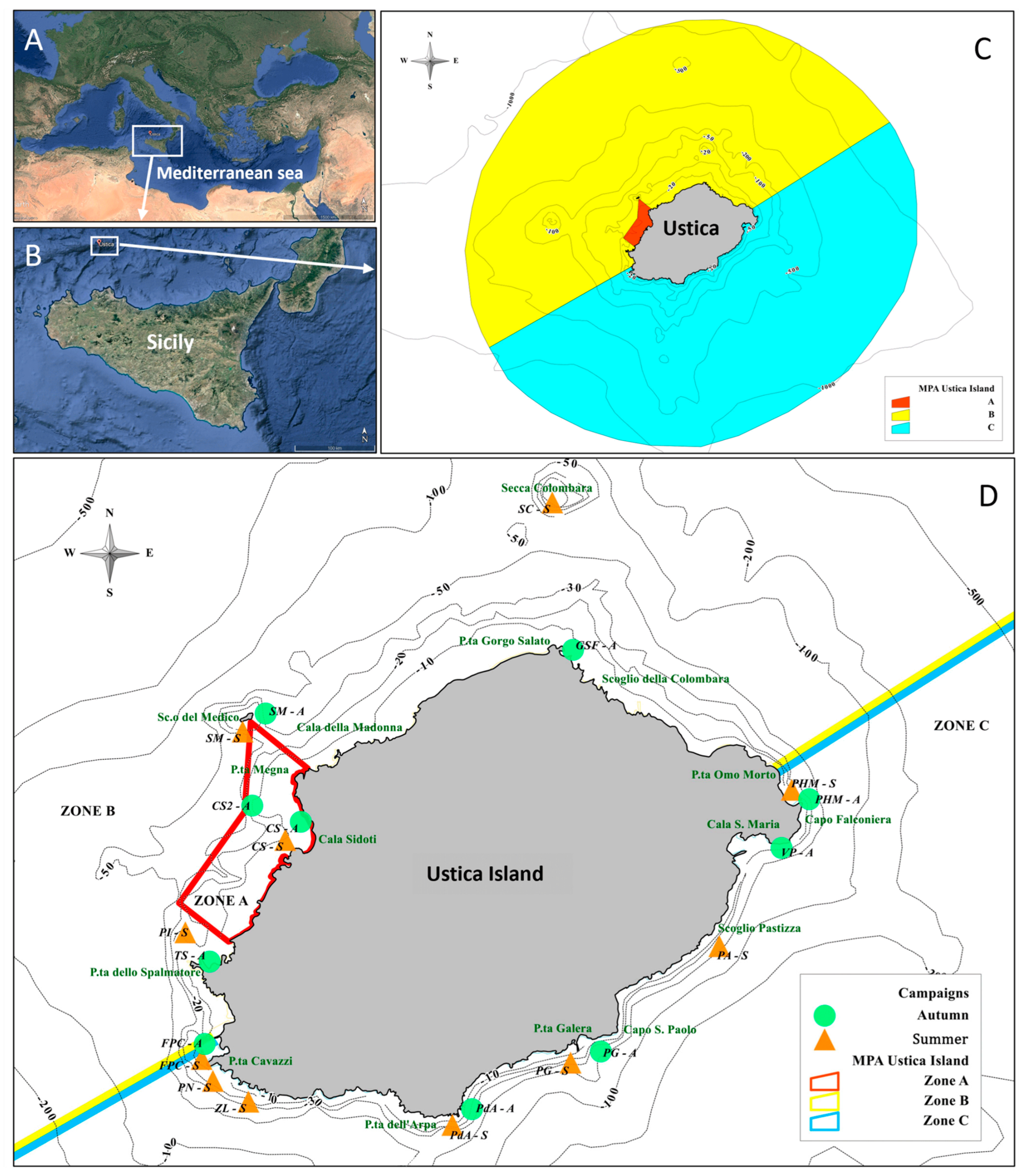
The Ustica Island MPA (Figure 1) covers approximately 16,000 ha and is divided into three protection zones (Figure 1C). Zone A (ca. 60 ha), located on the western side of the island, is a fully protected no-take area (integral reserve), where only scientific research is permitted. Bathing is allowed exclusively in two bays at the southernmost (Cala Acquario) and northernmost (Cala Sidoti) boundaries of the integral reserve. Zone B (ca. 7860 ha), surrounding zone A on both sides, is a general reserve where activities such as artisanal fishing, boating, and diving are regulated by the MPA management authority. Zone C, extending along the southern sector of the island, is a partial reserve where all activities are allowed, including professional and recreational fishing, anchoring, and diving, although these are still subject to specific regulations [8,9].

2.2. Sampling

Two field surveys were conducted as part of the MoVaFIsU project: the first in autumn (27 September–1 October 2024) and the second in summer (10–14 June 2025). Monitoring activities were carried out using a combination of scuba diving and snorkeling across 14 sites distributed among the three protection zones (A, B, and C) of the Ustica Island MPA (see Figure 1D; Table 1). In total, 13 snorkeling surveys and 8 scuba dives were conducted. Each survey lasted between 40 min and 1 h and covered an area of approximately 250 m2. Six sites were surveyed during both campaigns (Scoglio del Medico, Faro Punta Cavazzi, Punta Homo Morto, Punta dell’Arpa, Cala Sidoti and Punta Galera), while the remaining sites were surveyed during a single campaign. Differences in the number of sites surveyed between seasons, and in the use of snorkeling versus scuba diving, were primarily determined by site accessibility, distance from the coast, bathymetry, and sea-weather conditions, which can strongly constrain field operations around offshore islands such as Ustica Island. Monitoring of Fucalean stands was conducted using a random-course survey technique [34,35], which allows exploration of different habitats and depth ranges and is particularly suited to floristic assessments. Snorkeling surveys (0–1.5 m depth) were used to investigate the infralittoral fringe and upper infralittoral zone at coastal sites, while scuba dives were carried out perpendicularly to the coastline, following seabed geomorphology from the surface down to around 40 m. This depth range corresponds to the infralittoral zone, where Fucalean forests are mainly distributed. During surveys, Cystoseira s.l. and Sargassum species, forming recognizable vegetational belts, were visually identified and photographed using two underwater cameras (Olympus TG-6 and TG-4; Olympus Corporation, Tokyo, Japan). For each species, diacritical morphological characters (e.g., holdfast, main axes, branching pattern, apices, receptacles, and tophules, when present) were documented photographically. Canopy density was visually estimated “in situ” according to the semi-quantitative scale proposed by Thibaut et al. [36]: absence of individuals (1), scattered individuals (2), abundant patches (3), and almost continuous to continuous stands (4).
For each recorded species, up to two representative thalli displaying diagnostic characters were collected using a small pick, ensuring inclusion of the basal portion. Specimens were transported to the laboratory of the Ustica Island MPA (Visitor Centre) and preserved as wet samples (50% seawater-ethanol solution) and as exsiccata for subsequent analyses. Additionally, a subsample of each thallus was dried in silica gel for future molecular analyses. Voucher specimens are deposited at the Phycological Laboratory of the Department of Biological, Geological and Environmental Sciences, University of Catania, and at the laboratory of the Ustica Island MPA.

2.3. Data Analysis

Taxonomic identification was based on a combination of “in situ” observations, photographic documentation, and laboratory examination of diagnostic morphological characters under a stereomicroscope OPTECH series GZ 808 (Exacta Labcenter SPA, San Prospero, Modena, Italy). For fertile specimens, transverse sections of receptacles were prepared using a razor blade and examined under a light microscope OPTECH series BM 60 ICS (Exacta Labcenter SPA, San Prospero, Modena, Italy) to assess the maturity of conceptacles. Photographic documentation was also used to characterize vegetational belts at each site and to support canopy density estimates.
Species identification followed the main Mediterranean taxonomic keys [37,38,39,40], together with recent taxonomic revisions. Nomenclature and taxonomic status were updated according to AlgaeBase [41].
This study adopts a floristic and taxonomic framework to reassess Fucalean diversity within the Ustica Island MPA, integrating contemporary field surveys with a critical and taxonomically harmonized revision of historical records. Comparisons between past and present datasets were therefore conducted using a presence–absence approach, focusing on patterns of taxonomic persistence and turnover through time (Table 2).
Historical data for the Ustica Island MPA were compiled from published literature [10,11,12,13,14,15,16,17,18] and from herbarium specimens preserved in the CAT Herbarium (University of Catania). For each protection zone (A, B, and C), historical species lists were reconstructed based on the explicit attribution of sampling sites to MPA zones in the original sources. All historical records were critically revised and harmonized according to current taxonomy and nomenclature prior to comparison. Comparisons between historical and current species lists, and among protection zones, were visualized using InteractiVenn software (2015 edition) [42], allowing a clear representation of shared and exclusive taxa among datasets.

3. Results

3.1. Present Diversity and Spatial Distribution of Fucales at Ustica Island MPA

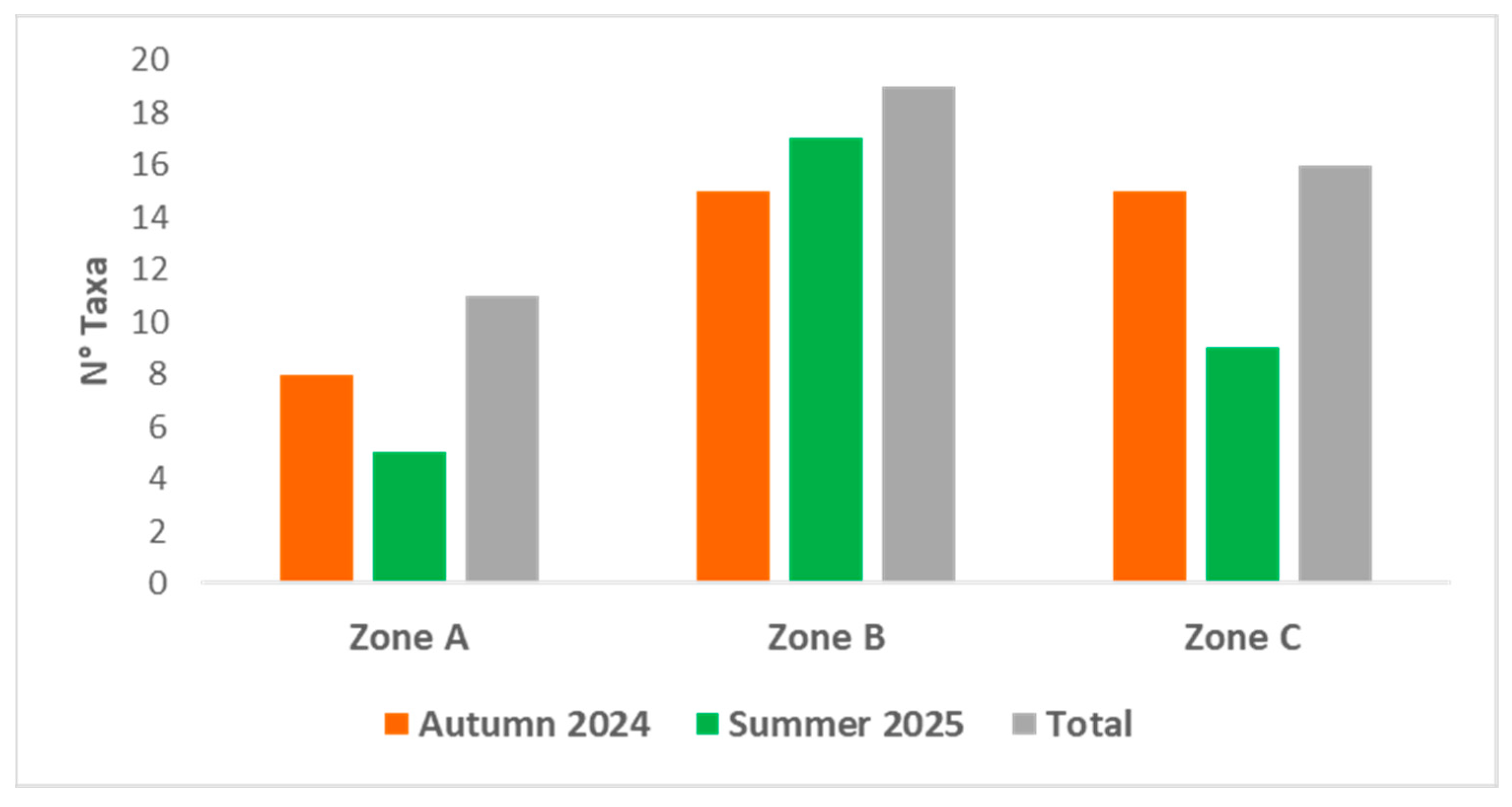
Overall, 20 taxa at the specific and infraspecific level (hereinafter referred to as species) were recorded during the surveys (11 in zone A, 19 in zone B, and 16 in zone C) (Figure 2): five belonging to Cystoseira sensu stricto (s.s.) (C. compressa, C. foeniculacea f. foeniculacea, C. foeniculacea f. latiramosa, C. foeniculacea f. tenuiramosa, C. pustulata), five to Ericaria (E. amentacea, E. balearica, E. brachycarpa, E. funkii, E. zosteroides), five to Gongolaria (G. elegans, G. montagnei var. montagnei, G. montagnei var. compressa, G. montagnei var. tenuior, G. sauvageauana), and five to Sargassum (S. acinarium, S. furcatum, S. cf. hornschuchii, S. trichocarpum, S. vulgare). All species are listed in alphabetical order in Table S1, together with their depth range and canopy density classes.
During the autumn campaign, 19 species were recorded (8 in zone A, 15 in zone B, and 15 in zone C), whereas 18 taxa were recorded in summer (5 in zone A, 17 in zone B, and 9 in zone C) (Figure 2, Table S1).
Across both campaigns, the highest canopy density classes (almost continuous to continuous stands) were most frequently observed for E. amentacea, E. brachycarpa, and E. funkii at multiple sites (Table S1). However, E. amentacea showed lower canopy density classes at some sites in zone C, ranging from scattered individuals at Villaggio dei Pescatori and Punta Homo Morto, to abundant patches at Punta dell’Arpa. Ericaria brachycarpa was observed as abundant patches in both campaigns at Cala Sidoti (zone A) and Pastizza (zone C), where E. funkii was also recorded as abundant patches (Table S1).
Seasonal differences in canopy density were observed for some species. Gongolaria montagnei v. compressa and G. sauvageauana exhibited higher canopy density classes in summer than in autumn. In autumn, G. montagnei v. compressa was recorded only at Punta Galera (zone C) as scattered individuals, whereas in summer, it occurred as abundant patches at Piramidi and Secca della Colombara (zone B) and as almost continuous to continuous stands at Punta Homo Morto, Punta dell’Arpa, and Punta Galera (zone C) (Table S1).
Similarly, G. sauvageauana was recorded in autumn as scattered individuals at Faro Punta Cavazzi and Torre Spalmatore (zone B) and at Punta Galera and Punta dell’Arpa (zone C), while it occurred as abundant patches at Cala Sidoti (zone A), Scoglio del Medico, Gorgo Salato Faraglione (zone B), and Punta Homo Morto (zone C). In summer, G. sauvageauana consistently formed dense canopies (almost continuous to continuous stands) in zone B (Piramidi, Scoglio del Medico and Secca della Colombara) (Table S1).
The sites exhibiting the highest species richness were Punta dell’Arpa (zone C, autumn: 11 taxa), Scoglio del Medico (zone B, summer and autumn: 13 and 11 taxa, respectively), and Secca della Colombara (zone B, summer: 14 taxa) (Table S1). In contrast, the lowest species richness was recorded at Zia Lisa (zone C, summer: three taxa), Torre Spalmatore (zone B, autumn: four taxa), Villaggio dei Pescatori (zone C, autumn; four taxa), and Gorgo Salato Faraglione (zone B, autumn: four taxa).
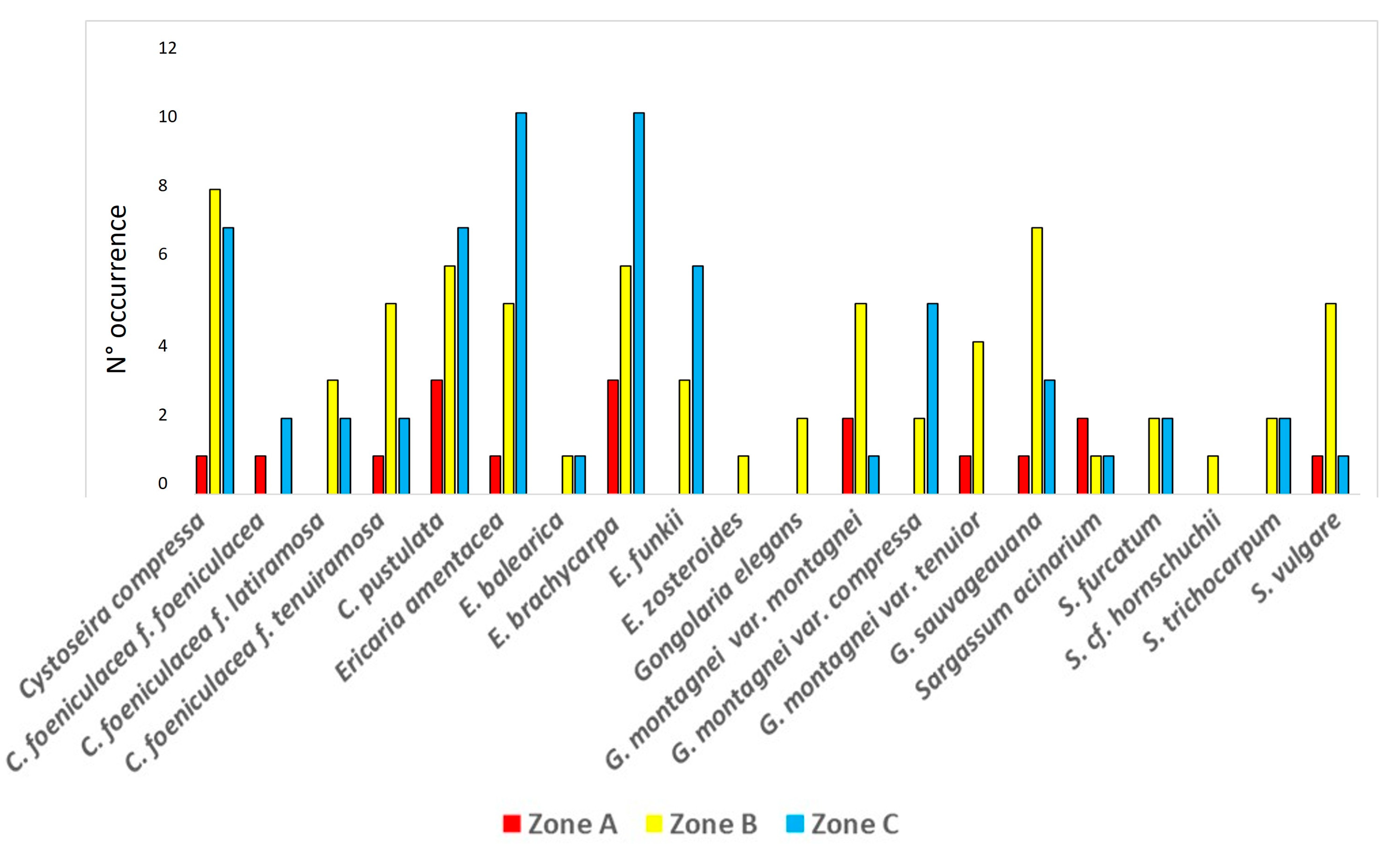
Overall, the most frequently recorded species were E. amentacea, E. brachycarpa, C. compressa, C. pustulata, and G. sauvageauana (Figure 3). In zone A, the most frequent species were E. brachycarpa and C. pustulata; in zone B, C. compressa, C. pustulata, E. brachycarpa, and G. sauvageauana; and in zone C, E. amentacea, E. brachycarpa, and C. compressa (Figure 3).
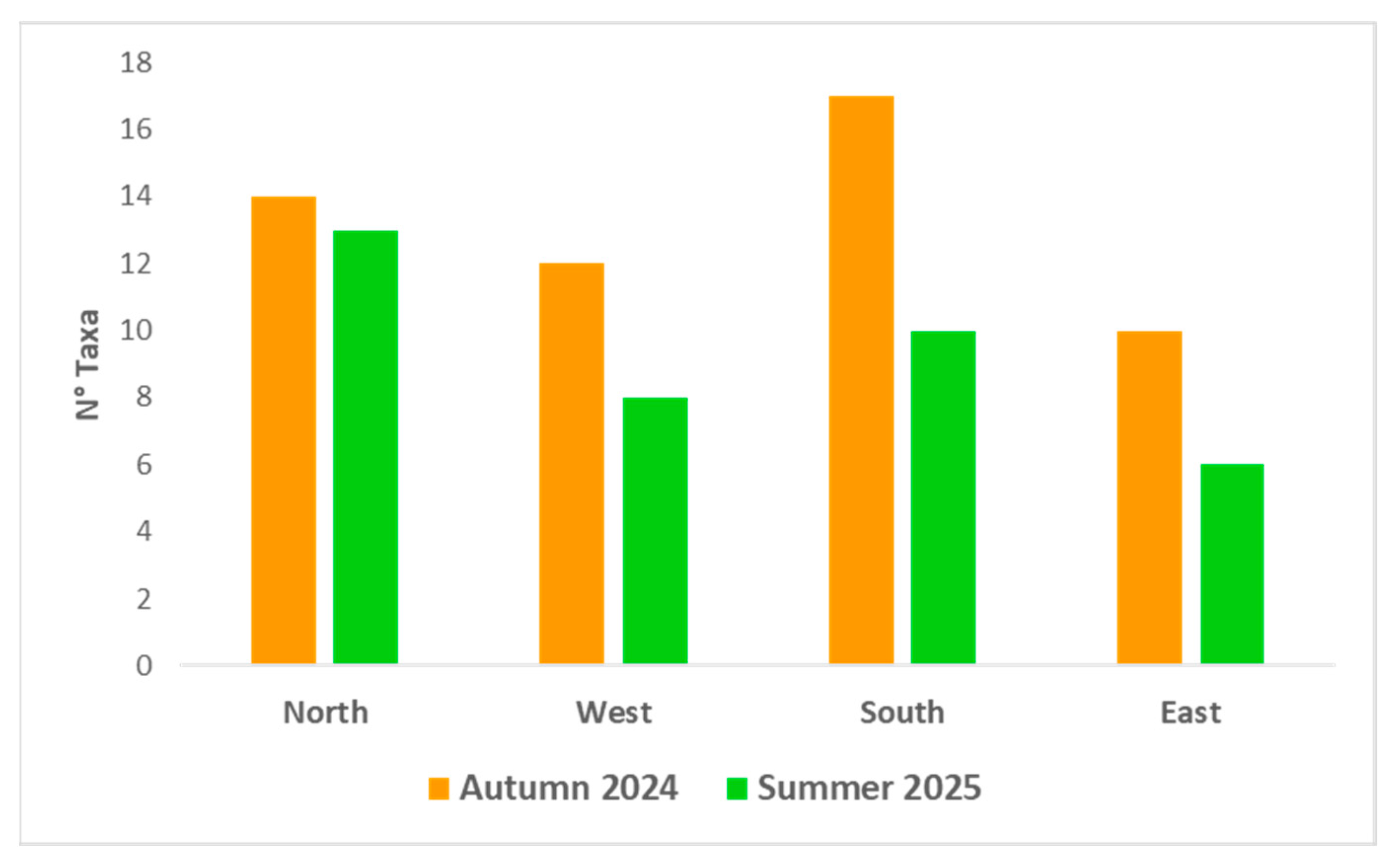
At the island scale, the northern sector hosted the highest overall species richness (18 species: 14 in autumn and 13 in summer), followed by the southern sector (17 species: 17 in autumn and 10 in summer). The western sector hosted 13 species (12 in autumn and 8 in summer), whereas the eastern sector showed the lowest richness (10 species: 10 in autumn and 6 in summer) (Figure 4).

3.2. Comparison with Previous Studies

Comparison of the present data with previous studies [10,11,12,13,14,15,16,17,18] (Table 2) indicated that 18 previously reported species are still present within the Ustica Island MPA: C. compressa, C. foeniculacea f. foeniculacea, C. foeniculacea f. latiramosa, C. foeniculacea f. tenuiramosa, C. pustulata, E. amentacea, E. balearica, E. brachycarpa, E. funkii, E. zosteroides, G. elegans, G. montagnei var. montagnei, G. montagnei var. compressa, G. montagnei var. tenuior, G. sauvageauana, S. acinarium, S. cf. hornschuchii, and S. vulgare. Five species previously reported were not recorded during the present surveys: C. pelagosae cf., E. brachycarpa var. claudiae, E. crinita, E. dubia, and G. squarrosa. Conversely, two species are reported here for the first time for the Ustica Island MPA: S. furcatum and S. trichocarpum (Table 2).
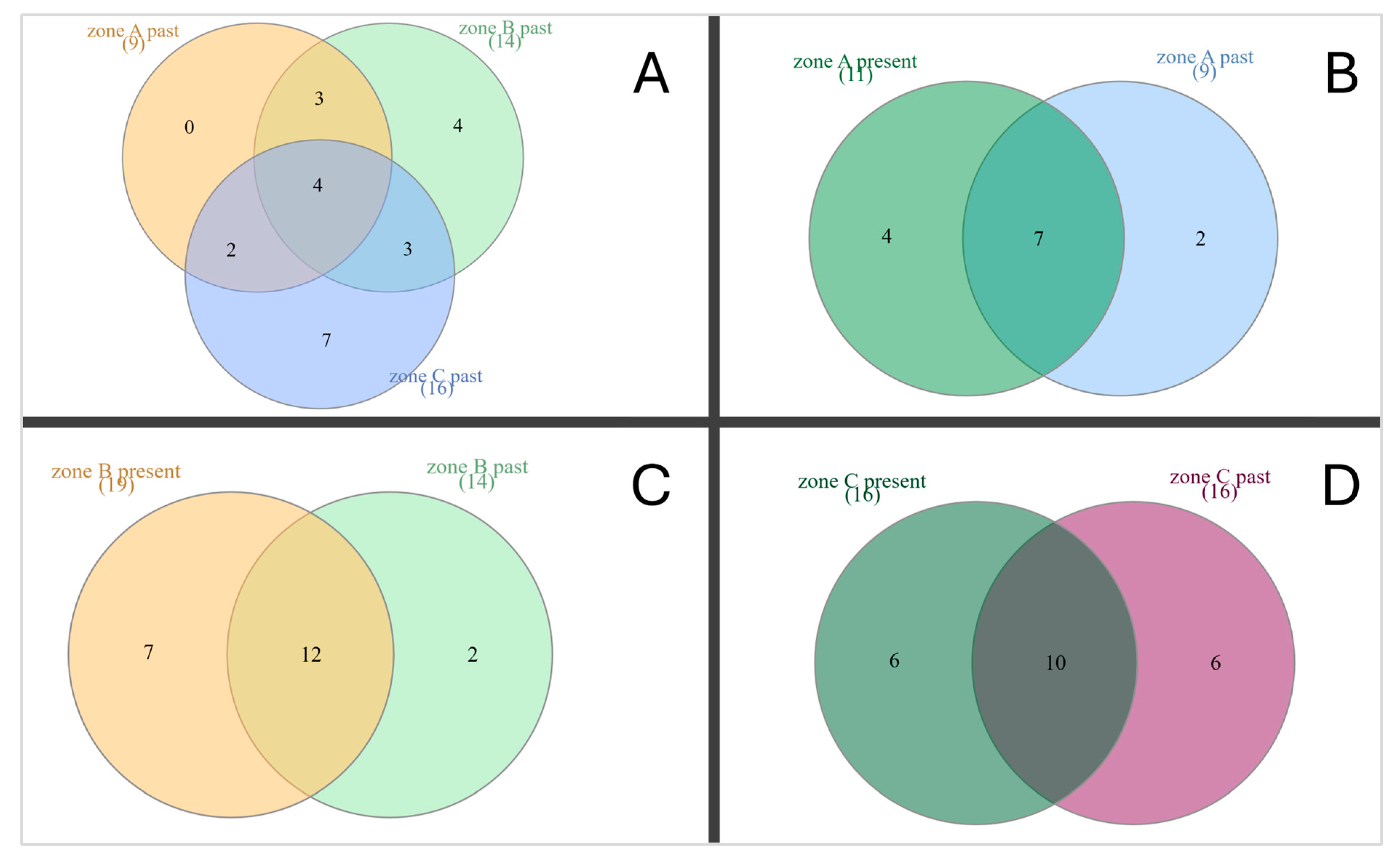
With respect to zoning, historical data indicate the presence of 9 species in zone A, 14 in zone B, and 16 in zone C. Four species were common to all three protection zones (C. compressa, E. amentacea, E. brachycarpa, and G. montagnei var. montagnei). Three species (C. pustulata, G. elegans, and G. sauvageauana) were shared between zones A and B, two (C. foeniculacea f. tenuiramosa and E. balearica) between zones A and C, and three (C. foeniculacea f. latiramosa, E. zosteroides, and S. vulgare) between zones B and C. Historically, zone C hosted seven species not reported from the other zones (C. pelagosae cf., E. funkii, E. brachycarpa v. claudiae, E. crinita, E. dubia, G. montagnei var. compressa, and G. montagnei var. tenuior) (Figure 5A).
Comparison between historical records and current data highlighted that seven species were shared between datasets in zone A (C. compressa, C. foeniculacea f. tenuiramosa, C. pustulata, E. amentacea, E. brachycarpa, G. montagnei var. montagnei, and G. sauvageauana; Figure 5B). In zone B, 12 species were common (C. compressa, C. foeniculacea f. latiramosa, C. pustulata, E. amentacea, E. brachycarpa, E. zosteroides, G. elegans, G. montagnei var. montagnei, G. sauvageauana, S. acinarium, S. vulgare, and S. cf. hornschuchii, Figure 5C). Finally, ten species were confirmed in zone C (C. compressa, C. foeniculacea f. latiramosa, C. foeniculacea f. tenuiramosa, E. amentacea, E. balearica, E. brachycarpa, E. funkii, G. montagnei var. compressa, G. montagnei var. montagnei, and S. vulgare, Figure 5D).
Species recorded in the current surveys but not documented in historical datasets comprised four species in zone A (C. foeniculacea f. foeniculacea, G. montagnei var. tenuior, S. acinarium, and S. vulgare; Figure 5B), seven in zone B (C. foeniculacea f. tenuiramosa, E. balearica, E. funkii, G. montagnei var. compressa, G. montagnei var. tenuior, S. furcatum, and S. trichocarpum; Figure 5C), and six in zone C (C. foeniculacea f. foeniculacea, C. pustulata, G. sauvageauana, S. acinarium, S. furcatum, and S. trichocarpum; Figure 5D). Conversely, taxa reported in historical datasets but not recorded in the current surveys comprised two species in zone A (E. balearica and G. elegans; Figure 5B), two in zone B (C. foeniculacea f. foeniculacea and G. squarrosa; Figure 5C), and six in zone C (C. pelagosae cf., E. zosteroides, E. brachycarpa var. claudiae, E. crinita, E. dubia, and G. montagnei var. tenuior; Figure 5D).

4. Discussion

During the MoVaFIsU project, we assessed the current diversity and spatial distribution of Fucalean stands within the Ustica Island MPA. Based on two field survey campaigns conducted in autumn 2024 and summer 2025, a total of 20 species were recorded, with 19 species detected in autumn and 18 in summer. Specifically, 11 species were recorded in zone A (eight in autumn and five in summer), 19 in zone B (15 in autumn and 17 in summer), and 16 in zone C (15 in autumn and nine in summer).
Overall, zone B exhibited the highest Fucalean taxonomic richness among the three protection zones. In particular, Secca della Colombara and Scoglio del Medico hosted the highest number of species (14 species and 13, respectively). At the island scale, the northern coast showed the highest Fucalean diversity (18 species), followed by the southern coast (17 species), whereas lower diversity was recorded along the western and eastern sides (13 and 10 species, respectively).
These spatial patterns are consistent with previous observations by Riggio and Milazzo [43], who reported higher biodiversity along the north-western and southern sectors of the island. This pattern has been attributed to the influence of Atlantic inflow, which may enhance recruitment processes, together with additional environmental drivers, such as geomorphology, substrate texture, and local hydrodynamics. Upwelling currents particularly affecting the north-western sector may further contribute to increased habitat heterogeneity and local diversity, as previously suggested for this area [43].
The most frequently recorded species across the island were E. amentacea, E. brachycarpa, C. compressa, C. pustulata, and G. sauvageauana. In zone A, the most common species were E. brachycarpa and C. pustulata; in zone B, C. compressa and G. sauvageauana; and in zone C, E. amentacea and E. brachycarpa. These species were also among those most frequently associated with higher canopy density classes (from abundant patches to continuous stands), particularly during the summer campaign.
Across both campaigns, E. amentacea, E. brachycarpa, and E. funkii were the species most consistently associated with the highest canopy-density classes at several sites. In contrast, G. sauvageauana and G. montagnei var. compressa displayed marked seasonal differences, with higher canopy-density classes during summer in zones B and C. Because sampling effort in zone A was necessarily limited (one SCUBA dive and two snorkeling surveys), a robust comparison of canopy-density patterns for this zone remains constrained, and interpretations should therefore be considered with caution.
The analysis of historical data [10,11,12,13,14,15,16,17,18] highlighted the presence of nine species in zone A, 14 in zone B, and 16 in zone C. Of these, seven species are still confirmed within zone A, 12 species in zone B, and ten species in zone C, indicating a substantial degree of taxonomic persistence within the MPA across protection zones. Overall, 18 of the taxa reported in previous studies are still present within the Ustica Island MPA, suggesting a relatively stable Fucalean assemblage through time.
In contrast, five species previously reported (C. pelagosae cf., E. brachycarpa var. claudiae, E. crinita, E. dubia and G. squarrosa) were not recorded during the present surveys. The absence of some shallow-water species, particularly E. crinita and G. squarrosa, may reflect complex ecological trajectories rather than a single causal driver. Following the establishment of protection measures in 1991, restrictions on sea-urchin harvesting led to increased densities of Paracentrotus lividus (Lamarck, 1816) and Arbacia lixula (Linnaeus, 1758), favored by the scarcity of their main fish predators (Diplodus spp.) [43,44]. This resulted in the formation of extensive barren grounds at shallow depths. Subsequent declines in sea-urchin populations, partly driven by predation from Marthasterias glacialis (Linnaeus, 1758), have been associated with partial recovery of Fucalean stands approximately a decade later [44].
For deeper-water species (e.g., C. pelagosae cf., E. brachycarpa var. claudiae and E. dubia), physical disturbance related to anchoring activities represents a plausible contributing factor, as anchoring can cause direct damage to canopy-forming algae through uprooting and abrasion of the rocky substrate [43]. However, given the qualitative nature of historical data and the presence–absence approach adopted here, these interpretations should be regarded as hypotheses requiring targeted investigation rather than as definitive causal explanations. Two species are reported here for the first time within the Ustica Island MPA: S. furcatum and S. trichocarpum. This finding is particularly noteworthy, as five of the nine Sargassum species reported for the Mediterranean Sea occur around Ustica island [45]. Sargassum furcatum is a non-indigenous species native to the western Atlantic and the Pacific Ocean that has recently been reported as expanding into the Mediterranean Sea (e.g., Moroccan coasts, French Mediterranean coastline, Corsica, and several locations around Sicily) [40,41,46,47]. Its occurrence at Ustica Island provides additional evidence of the ongoing spread of this warm-affinity species, consistent with the warming-driven tropicalization trends reported for Mediterranean waters.
Sargassum trichocarpum is a Mediterranean endemism [45], with a distribution spanning Algeria, Tunisia, Libya, Cyprus, Greece, Israel, Italy, France, and Spain [40]. Its most recent confirmed record dates to 2021 from northern Catalonia [48], supporting its status as a rare species. The finding of S. cf hornschuchii is also noteworthy, as it represents the first observation at Ustica after approximately 40 years since the last record by Giaccone et al. [12]. In addition, S. trichocarpum, S. acinarium, S. flavifolium, and S. hornschuchii are listed in Annex II of the Barcelona Convention as Mediterranean endangered or threatened species [49]. According to Verlaque et al. [49], S. trichocarpum is currently classified as vulnerable, whereas S. acinarium and S. hornschuchii are considered endangered. Therefore, the occurrence of these species within the Ustica Island MPA has high conservation relevance and should be explicitly considered when defining future monitoring priorities and management strategies.
Some limitations should be acknowledged. Not all coastal sectors of the island were surveyed, and the temporal coverage was limited to two seasonal campaigns, which may have resulted in the under-detection of rare or highly seasonal taxa. In addition, for some taxonomically critical species, integrative approaches including molecular analyses will be necessary to confirm species identity. Despite these limitations, the results indicate an overall stability in taxonomic richness through time in zones A and C, and a higher number of recorded species in zone B. This apparent increase should be interpreted cautiously, as historical data do not uniformly report site attribution to protection zones.
Taken together, these patterns suggest that the combination of favorable environmental conditions and the current management framework of the MPA, may provide suitable conditions for the persistence of Fucalean forests.
From a management perspective, additional preventive measures, such as increasing the availability of mooring buoys, particularly in the northern sector where the highest diversity was recorded, could further reduce physical disturbance to canopy-forming assemblages.
Given the exceptionally high diversity of Sargassum and Cystoseira s.l. forests at the Ustica Island MPA relative to many other Mediterranean areas, regular and standardized monitoring programs are recommended to timely detect emerging threats and early signs of regression. Finally, initiatives targeted to strengthen public and institutional awareness should accompany conservation actions, given the key ecosystem-engineering role of these forests and their vulnerability to cumulative pressures [50].

5. Conclusions

Over the last 60 years, Fucales have undergone a marked decline across many Mediterranean regions [28,29,30]. Nevertheless, a limited number of sites, particularly well-managed MPAs, such as the Ustica Island MPA and the Port-Cros National Park [36], still support well-structured and spatially extensive Fucales stands. The high diversity recorded at Ustica Island MPA is likely favored by the interplay of regional oceanographic features (e.g., Atlantic inflow and nutrient enrichment associated with upwelling processes) and local geomorphological characteristics, including substrate roughness and heterogeneity. These interacting drivers may contribute to making Ustica island one of the major Mediterranean hotspots, comparable to the Strait of Messina, the Sicily Channel, and the Alboran Sea [43].
From a conservation and management perspective, the Ustica Island MPA emerges as a priority site for safeguarding Mediterranean Fucalean forests. Sustained and standardized monitoring is essential to detect early signs of regression and emerging pressures, track the dynamics of rare and threatened taxa, and provide an evidence base for adaptive management. This study provides a robust baseline on the taxonomic richness and spatial distribution of Fucales within the Ustica Island MPA, which can inform future monitoring programs and support evidence-based management. Maintaining the ecological integrity of these canopy-forming forests is pivotal for securing the structural and functional foundations of shallow rocky ecosystems within the MPA and for sustaining the associated biodiversity that depends on them.

6. Annotated Species Accounts and Diagnostic Characters of Recorded Fucalean Taxa

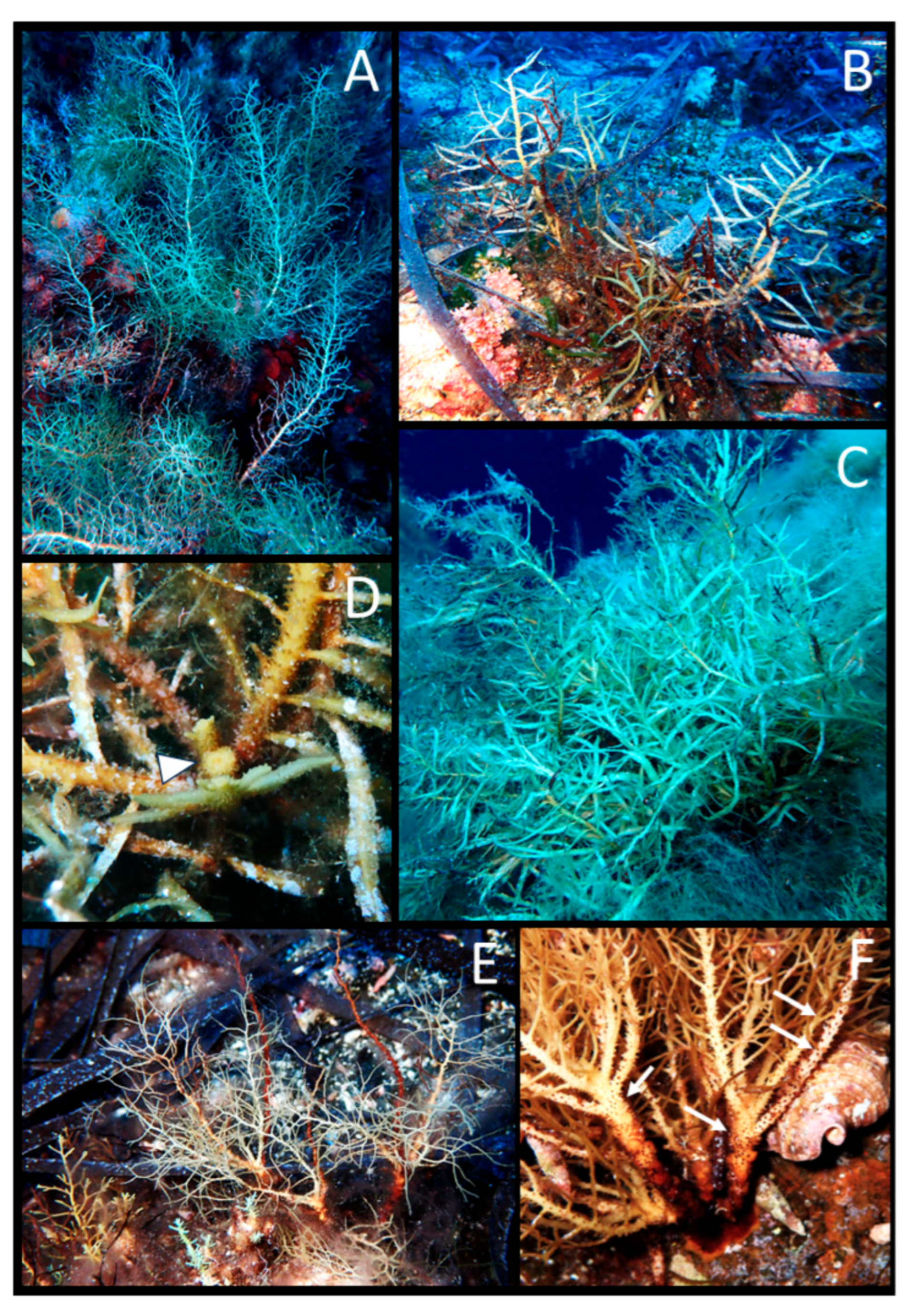
  • Cystoseira compressa (Esper) Gerloff et Nizamuddin (Figure 6A–D)
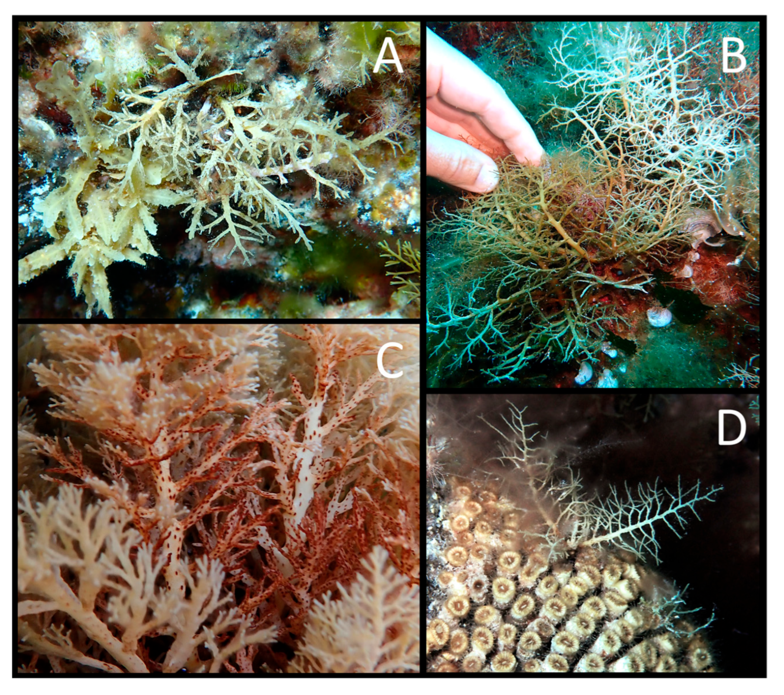
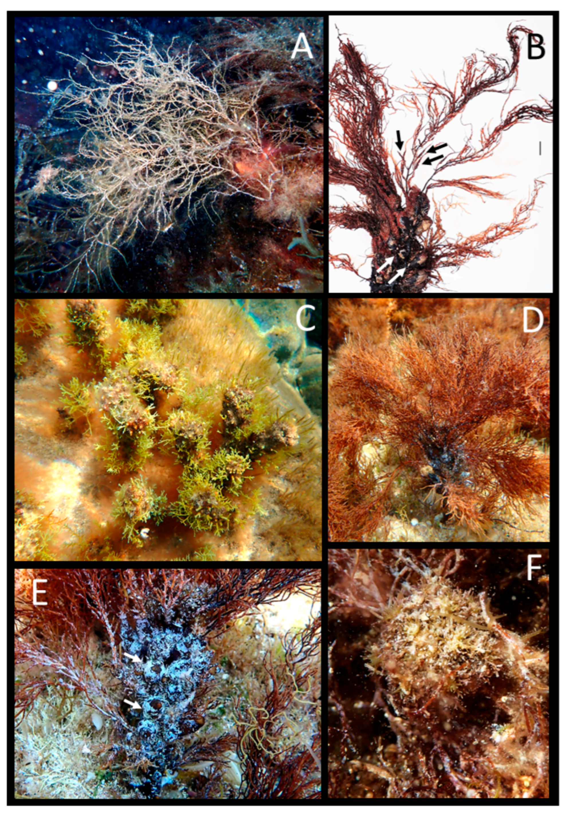
Morphological description: Thalli are caespitose (Figure 6A,B) and attached to the substrate by a small discoid holdfast. The apex is small and not prominent. Axes and primary branches may be densely covered by slightly protruding cryptostomata (Figure 6C). Primary branches are flattened with alternate–distichous branching (Figure 6A–D), while higher-order branches can be flattened or cylindrical with the same branch arrangement. In autumn, usually, thalli typically show a less developed branching system (Figure 6A), while in summer, they display a denser and more extensive branching system (Figure 6B). Receptacles are simple or branched, tiny and fusiform, often located at the top of an aerocyst.
Habitat: This species is widely distributed around Ustica Island. During the autumn campaign, it was recorded in zone B (Faro Punta Cavazzi, Torre Spalmatore, Scoglio del Medico, Gorgo Salato and Faraglione) and C (Villaggio dei Pescatori), while in summer, it was recorded at all surveyed sites. In autumn, it occurred from 0.1 to about 8 m, mostly as scattered individuals, while at Villaggio dei Pescatori it formed abundant patches. In summer, canopy density was generally higher: at Pastizza it formed almost continuous stands, at Scoglio del Medico, Secca della Colombara, Faro Punta Cavazzi, Cala Sidoti and Punta Galera, it formed abundant patches, whereas at Zia Lisa, Punta dell’Arpa, Punta Homo Morto, Piramidi, and Piscina Naturale, only scattered thalli were observed. Notably, in summer, young thalli of C. compressa were observed growing on the scleractinian coral Cladocora caespitosa (Linnaeus, 1767) (Figure 6C).
Remarks: Cystoseira compressa was previously reported at Ustica Island by Giaccone et al. [12], Milazzo et al. [13], Badalamenti et al. [14], Drago et al. [15], Catra et al. [16], and Ge.B.Ec.Sud [17], in a depth range of 0–20 m.
Figure 6. Cystoseira compressa. (A) Autumn habit; (B) summer habit; (C) detail of the axis with cryptostomata; (D) a small thallus growing on the scleractinian coral Cladocora caespitosa.
Environments 13 00101 g006
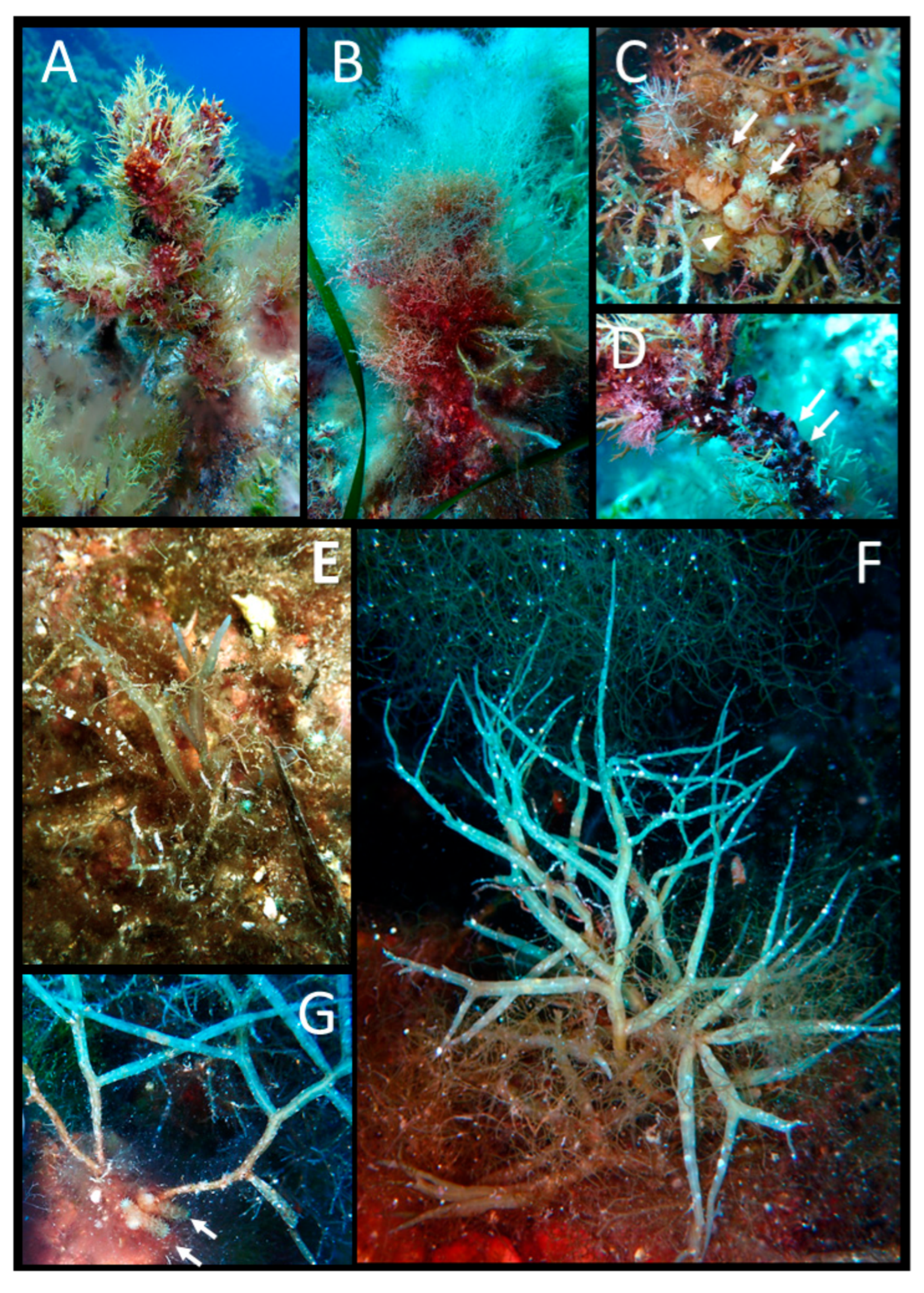
  • Cystoseira foeniculacea (Linnaeus) Greville f. foeniculacea (Figure 7A)
Morphological description: Thalli are caespitose and attached to the substrate by a wide, irregular discoid holdfast. Axes and primary branches are covered with small spines. Primary branches are both cylindrical and flattened, with a central midrib and serrated margins, bearing secondary branches with an alternate-distichous arrangement. Higher-order branches are filiform, divaricate, alternating in several planes (Figure 7A). The apex is spinose and slightly prominent. No fertile specimens were observed during both campaigns.
Habitat: This species was recorded only during the autumn campaign, in zone A (Cala Sidoti) and zone C (Punta dell’Arpa and Punta Galera). At Cala Sidoti, it occurred at 0.3 m as scattered thalli, whereas at Punta dell’Arpa (9–27 m) and Punta Galera (10–15 m), it formed abundant patches.
Remarks: Cystoseira foeniculacea was previously reported at Ustica Island by Giaccone [10] at 42–55 m.
  • Cystoseira foeniculacea f. latiramosa (Ercegovic) A. Gómez Garreta, M. C. Barceló, M. A. Ribera & J. R. Lluch (Figure 7B–D)
Morphological description: Thalli are caespitose and, as in the previous form, show a knotty habit due to small spiniform appendages covering axes and primary branches. They are attached to the substrate by an irregular discoid holdfast. All primary and higher-order branches are compressed and flattened (Figure 7B,C), with a central midrib and serrated margins, and show an alternate–distichous arrangement. Thalli were less developed in autumn, a condition often associated with seasonal storm activity, while in summer, they reached maximum vegetative development (Figure 7C). The apex is spinose and slightly prominent (Figure 7D). No fertile specimens were observed during both campaigns.
Habitat: This form was recorded in both campaigns: in autumn, in zone B (Scoglio del Medico) and zone C (Punta dell’Arpa and Punta Galera), whereas in summer, it was found only in zone B (Scoglio del Medico and Secca della Colombara). In autumn, it occurred as scattered individuals at 25–36 m, while in summer, it formed abundant patches in zone B at 20–30 m.
Remarks: Cystoseira foeniculacea f. latiramosa was previously reported by Giaccone [10,11], Giaccone et al. [12], Catra et al. [16], and Ge.B.Ec.Sud [17], in a depth range of 10–40 m.
  • Cystoseira foeniculacea f. tenuiramosa (Ercegović) A. Gómez Garreta, M. C. Barceló, M. A. Ribera et J. Rull Lluch (Figure 7E,F)
Morphological description: Thalli are caespitose (Figure 7E), and, as in the other forms, show a knotty habit due to small spiniform appendages covering axes and primary branches (Figure 7F). They are attached to the substrate by a cylindrical discoid holdfast. Primary branches are cylindrical and knotty, sometimes compressed, bearing cylindrical higher-order branches; ultimate branchlets are filiform. Thalli exhibited no clear differences in overall size between autumn and summer. The apex is spinose and slightly prominent. No fertile specimens were observed during both campaigns.
Habitat: This form was recorded in both campaigns: in autumn, in zone A (Cala Sidoti, during snorkeling), zone B (Scoglio del Medico), and zone C (Punta Homo Morto), whereas in summer, it was detected in zone B (Scoglio del Medico, Secca della Colombara, Faro Punta Cavazzi and Piramidi) and zone C (Piscina Naturale). In autumn it occurred at 0.3–8 m as scattered individuals. In summer, it occurred at 0.1–30 m, mostly scattered individuals, except at Secca della Colombara and Piramidi, where it formed abundant patches.
Remarks: Cystoseira foeniculacea f. tenuiramosa was previously reported by Giaccone et al. [12], Milazzo et al. [13], Badalamenti et al. [14], and Ge.B.Ec.Sud [17], in a depth range of 15–30 m.
Figure 7. Cystoseira foeniculacea. f. foeniculacea: (A) autumn habit; f. latiramosa: (B) autumn habit; (C) summer habit; (D) smooth apex (arrowhead); f. tenuiramosa: (E) autumn habit; (F) thorny axes (arrows).
Environments 13 00101 g007
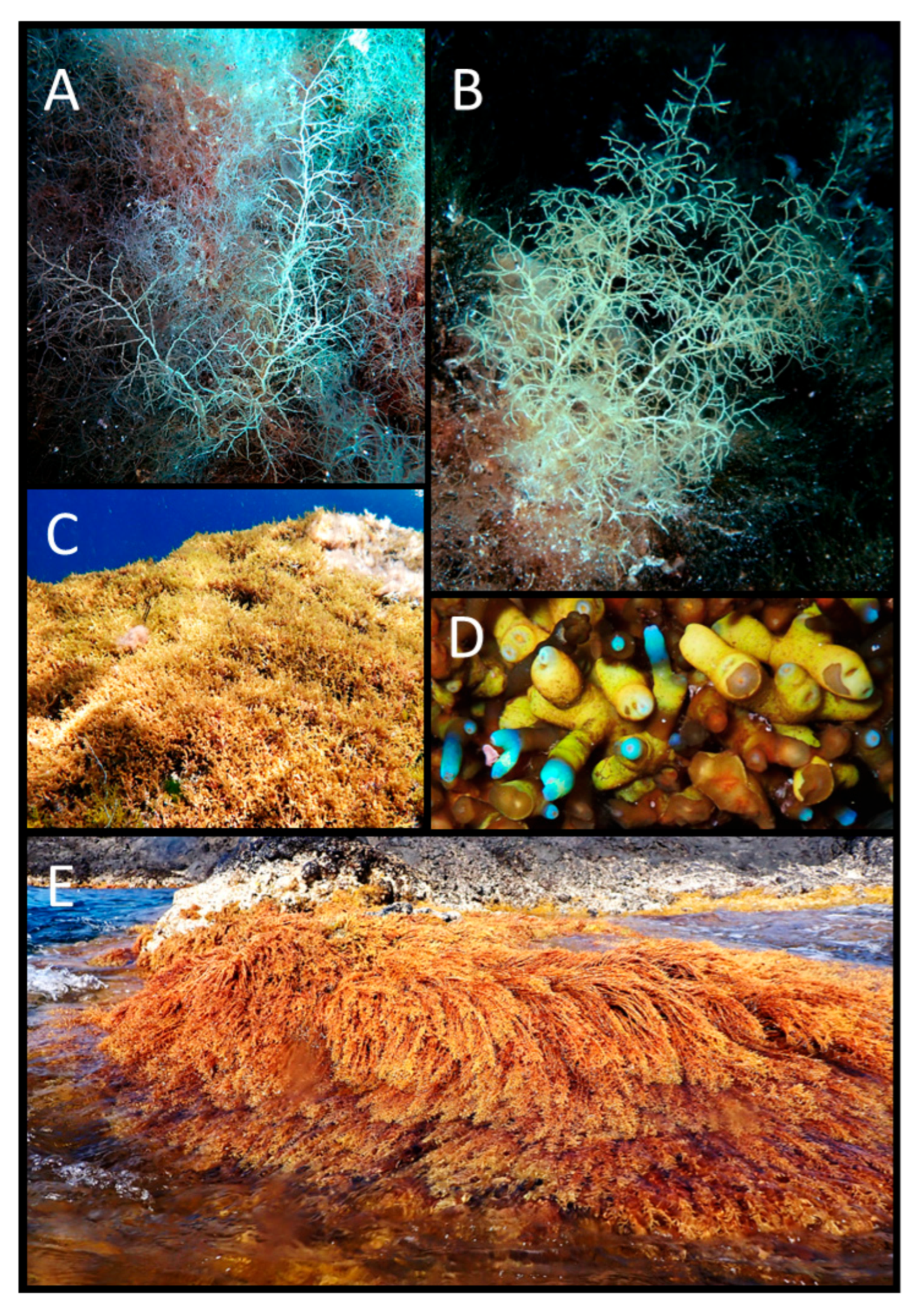
  • Cystoseira pustulata (Ercegović) Neiva et Serrão (Figure 8A,B)
Morphological description: Thalli are caespitose, delicate and slender, attached by a small discoid holdfast. Primary branches are cylindrical to slightly flattened with an alternate-distichous arrangement (Figure 8A,B). The thallus surface is densely covered by prominent cryptostomata, conferring a characteristic pustulate appearance. Higher-order branches are cylindrical and slender. Apex is smooth and not prominent. Tiny, fusiform, to lanceolate receptacles were observed in summer.
Habitat: This species was recorded in both campaigns: in autumn in zone A (Cala Sidoti, during snorkeling and scuba diving), zone B (Faro Punta Cavazzi and Scoglio del Medico), and zone C (Villaggio dei Pescatori and Punta dell’Arpa). In summer, it was observed at all surveyed sites except Zia Lisa (in zone C). In autumn, it occurred at 0.1–8 m as scattered individuals, while in summer, it was observed from 0.1 to 20 m of depth, always as scattered individuals.
Remarks: This species was previously reported at Ustica Island by Catra et al. [16] as Cystoseira humilis Schousboe ex Kützing. Molecular analyses by Neiva et al. [51] indicate that C. humilis is distributed in the Atlantic Ocean, and that Mediterranean records may represent misidentifications referable to C. pustulata. In the CAT Herbarium, two specimens from Ustica labeled as Cystoseira myriophylloides were also found. C. myriophylloides Sauvageau is currently recognized as a synonym of Cystoseira humilis Schousboe ex Kützing var. myriophylloides (Sauvageau) J. H. Price & D. M. John, which appears to occur in the Atlantic (from England to the Iberian Peninsula), and in the Mediterranean Sea (Tunisia and Adriatic Sea) [37]. Further molecular analyses will be required to clarify the identity and biogeographic affinities of these Ustica specimens.
Figure 8. Cystoseira pustulata. (A) Autumn habit; (B) summer habit; Ericaria amentacea; (C) autumn habit; (D) autumn holdfast detail; (E) summer habit.
Environments 13 00101 g008
  • Ericaria amentacea (C. Agardh) Molinari et Guiry (Figure 8C–E)
Morphological description: Thalli are caespitose and strongly attached to the substrate by a wide anchoring structure formed by the confluence of prostrate thallus portions. The apex is not prominent and is located close to the holdfast. Primary branches are cylindrical and robust, bearing cylindrical and flexuous higher-order branches arranged in a pyramidal shape. Spinose appendages cover all branches. In autumn, this species loses most fronds and only the basal portions and the axes remain, giving the appearance of a freshly cut lawn (Figure 8C,D). In summer, thalli reach maximum vegetative development (Figure 8E). Receptacles were not observed in either campaign.
Habitat: This species was recorded in both campaigns: in autumn, it occurred in zone B (Torre Spalmatore, Scoglio del Medico and Gorgo Salato Faraglione) and zone C (Punta Homo Morto, Villaggio dei Pescatori, Punta dell’Arpa and Punta Galera), whereas in summer, it was recorded in zone A (Cala Sidoti), zone B (Scoglio del Medico and Faro Punta Cavazzi), and zone C (Pastizza, Punta dell’Arpa, Zia Lisa, Punta Homo Morto, Punta Galera and Piscina Naturale). In autumn, it occurred from 0 to 0.5 m as scattered individuals at Villaggio dei Pescatori, as abundant patches at Punta dell’Arpa, and as continuous to almost continuous stands at Punta Homo Morto, Torre Spalmatore, Punta Galera, Scoglio del Medico, and Gorgo Salato Faraglione. In summer, it occurred within a similar depth range as continuous to almost continuous stands, except at Punta Homo Morto, where scattered individuals were observed.
Remarks: This species was previously reported at Ustica Island by Giaccone [11], Giaccone et al. [12], Badalamenti et al. [14], and Catra [16].
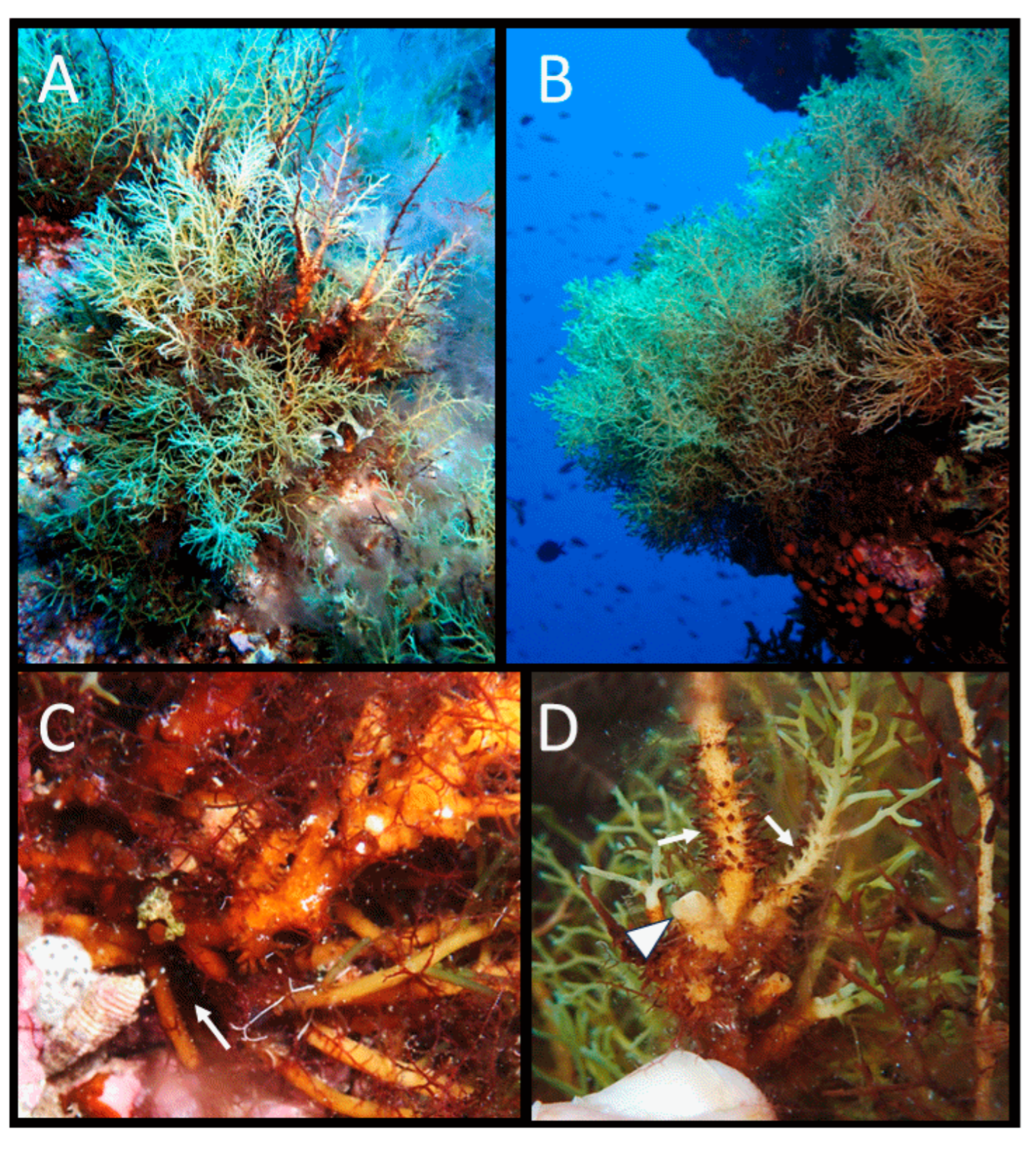
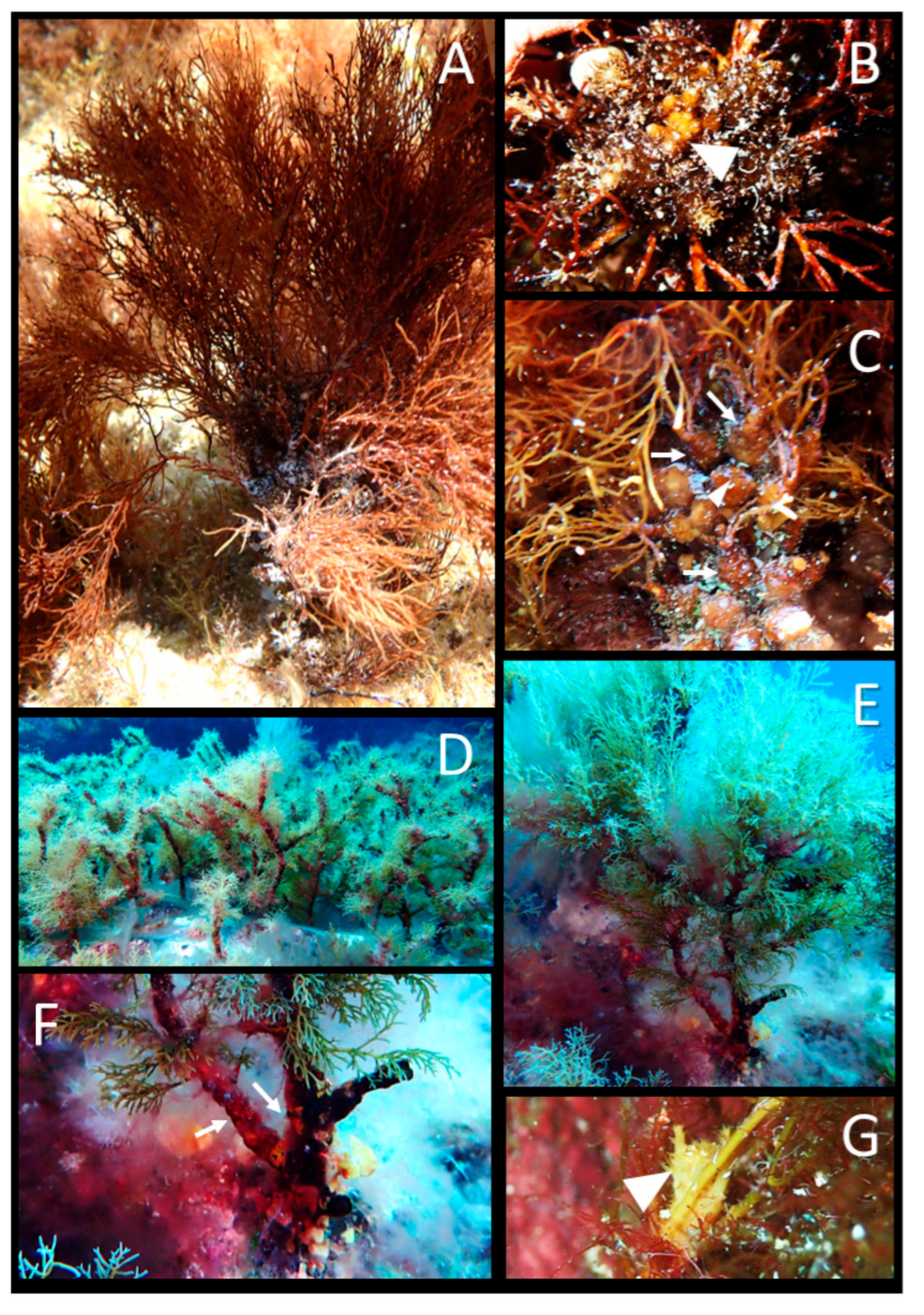
  • Ericaria brachycarpa (J. Agardh) Molinari et Guiry var. brachycarpa (Figure 9A–D)
Morphological description: Thalli are caespitose (Figure 9A,B) and attached by an irregular encrusting holdfast (Figure 9C). The apex is smooth and not prominent (Figure 9D). Primary branches are cylindrical and may show small spines near the base (Figure 9D), while higher-order branches are cylindrical and lack spines. At the end of summer, thalli tend to lose fronds, and in autumn, vegetative renewal results in the appearance of young greenish branchlets. In summer, thalli reach maximum vegetative development. Receptacles were not observed in either campaign.
Habitat: This species was recorded in both campaigns: in autumn in zone A (Cala Sidoti, during snorkeling and scuba diving), zone B (Faro Punta Cavazzi and Scoglio del Medico), and zone C (Punta Homo Morto, Villaggio dei Pescatori, Punta dell’Arpa and Punta Galera), whereas in summer, it was recorded at all the surveyed sites. In autumn, it occurred at 0-15 m as continuous to almost continuous stands, except during scuba diving at Cala Sidoti, where abundant patches were recorded. In summer, it occurred within the same depth range (0–15 m), as continuous to almost continuous populations.
Remarks: During the autumn campaign, stands of E. balearica were also recorded in zones B (Torre Spalmatore; 0.1–0.3 m) and C (Punta Homo Morto; 5–15 m), forming continuous to almost continuous stands. In the past, both E. brachycarpa and E. balearica were reported at Ustica Island within 1–30 m. E. brachycarpa was reported by Giaccone et al. [12], Milazzo et al. [13], Badalamenti et al. [14], Drago et al. [15], Catra et al. [16], and Ge.B.Ec.Sud [17], while E. balearica was recorded by Giaccone et al. [12], Milazzo et al. [13], Badalamenti et al. [14], and Ge.B.Ec.Sud [17].
Neiva et al. [51] highlighted that E. brachycarpa and E. balearica are cryptic species, genetically differentiated taxa with largely separated geographic ranges. To date, E. balearica is present in the Balearic Sea and in the Sicilian Island of Pantelleria, while E. brachycarpa is present in Greece and along the northern coast of Sicily [51]. Accordingly, molecular analyses would be required to assess whether both entities occur at Ustica Island.
Figure 9. Ericaria brachycarpa. (A) Autumn habit; (B) summer habit; (C) encrusting holdfast (arrow); (D) smooth apex (arrowhead) and basal spines on primary branches (arrows).
Environments 13 00101 g009
  • Ericaria funkii (Gerloff & Nizamuddin) Molinari & Guiry (Figure 10A–E)
Morphological description: Thalli are not caespitose, with a single axis that divides prematurely, and are attached to the substrate by a deeply digitate holdfast with branched haptera. Primary and higher-order branches are cylindrical (Figure 10A,B) and covered by spinose appendages. The apex is smooth, not prominent (Figure 10C), and shows a strong iridescence “in situ”. Tophules are oblong, spinose, and arranged in a corymb, especially in the apical zone of the axis. This confers a coralloid appearance to the basal part of the thallus (Figure 10D).
In autumn, most fronds disappear, and the tophules become more visible (Figure 10A). In summer, the fronds reach maximum development (Figure 10B), and receptacles begin to develop. Receptacles are cylindrical, diffuse, and bear spinose appendages (Figure 10E).
Habitat: This species was recorded in both campaigns in zone B (Scoglio del Medico and Secca della Colombara) and zone C (Punta dell’Arpa, Punta Galera, Pastizza and Punta Homo Morto), from approximately 20 to 35–36 m, forming continuous to almost continuous stands. At Pastizza, E. funkii occurred as abundant patches at 18–21 m.
Remarks: This species was previously reported at Ustica Island by Catra et al. [16] and Ge.B.Ec.Sud [17], at a depth of about 20 m.
Figure 10. Ericaria funkii. (A) Autumn habit; (B) summer habit; (C) apex detail (arrowhead); (D) spinose tophules (arrows); (E) branches with immature receptacles (arrows).
Environments 13 00101 g010
  • Ericaria zosteroides (C. Agardh) Molinari & Guiry (Figure 11A,B)
Morphological description: Thalli are not caespitose (Figure 11A), with a single short axis that branches by elongation and are attached to the substrate by strong digitiform aptera. Primary branches are cylindrical or slightly flattened, while higher-order branches are flattened and ribbon-like with a weak midrib. The apex is smooth and not prominent. Tophules are oblong, smooth, and distributed along the entire thallus length (Figure 11B). Receptacles are fusiform–lanceolate, with a knurled surface and small spines, and occur in an intercalated position on the primary and secondary branches (Figure 11B).
Habitat: This species was recorded only in summer at Secca della Colombara (zone B) as scattered individuals at 30–31 m.
Remarks: Ericaria zosteroides was previously reported at Ustica Island by Giaccone [10,11], Giaccone et al. [12] and Catra et al. [16], from 45 to 60 m.
Figure 11. Ericaria zosteroides. (A) Summer habit; (B) intercalary receptacles (black arrows) and smooth tophules (white arrows) in a thallus photographed in the laboratory (bar = 1cm); Gongolaria elegans. (C) Autumn habit; (D) summer habit; (E) axis with tophules (arrows); (F) characteristic cauliflower top of the cauloid.
Environments 13 00101 g011
  • Gongolaria elegans (Sauvageau) Molinari & Guiry (Figure 11C–F)
Morphological description: Thalli are not caespitose, with a single short axis that may be single or branched and are attached to the substrate by a robust discoid holdfast. Primary branches are cylindrical and bare at the base, higher-order branches, cylindrical and bear spinose appendages. In autumn, most fronds are lost, and only the cauloid with the tophules and buds of primary branches remain (Figure 11C). In summer, fronds are well developed (Figure 11D). Tophules are ovoid, covered by spinose appendages and grouped along the axis, particularly near the apex (Figure 11E). The apex is spinose and not prominent, scarcely visible due to the characteristic cauliflower-like appearance of the cauloid top (Figure 11F). Receptacles were not observed in either campaign.
Habitat: This species was recorded in both campaigns at Faro Punta Cavazzi (zone B) as scattered individuals from 0.3 to 0.5 m of depth.
Remarks: Gongolaria elegans was previously reported by Giaccone et al. [12], Milazzo et al. [13], Badalamenti et al. [14], and Catra et al. [16] at 3–5 m.
  • Gongolaria montagnei var. montagnei (J. Agardh) Kuntze (Figure 12A–D)
Morphological description of specimens: Thalli are not caespitose, with a single trunk-like axis that may be simple or branched and are attached to the substrate by a robust discoid holdfast (Figure 12A,B). Primary and higher-order branches may be cylindrical or slightly flattened and are covered by spinose appendages. In autumn, thalli lose most fronds and only the cauloid covered by tophules and buds of primary branches remains (Figure 12A), whereas in summer, fronds reach maximum vegetative development (Figure 12B). The apex is smooth and not prominent (Figure 12C). Tophules are ovoid, spinose, and located along the cauloid (Figure 12D). Receptacles were not observed in either campaign.
Habitat: This species was recorded in both campaigns: in autumn in zone A (Cala Sidoti, during snorkeling and scuba diving), zone B (Faro Punta Cavazzi, Scoglio del Medico and Gorgo Salato Faraglione), and zone C (Punta dell’Arpa), while in summer, it was recorded only in zone B (Scoglio del Medico and Secca della Colombara). Across campaigns, it occurred at 0.3–30 m, as abundant patches.
Remarks: Gongolaria montagnei var. montagnei was reported in the past by Giaccone [10,11], Giaccone et al. [12], Milazzo et al. [13], Badalamenti et al. [14], Catra et al. [16], and Ge.B.Ec.Sud [17], from 7 to 53 m of depth.
  • Gongolaria montagnei var. compressa (Ercegović) Verlaque, Blanfuné, Boudouresque & Thibaut (Figure 12E–G)
Morphological description: Thalli are not caespitose, with a single trunk-like axis that be simple or branched and is usually shorter than in the autonymous variety. Primary branches are cylindrical near the base and flattened distally. Higher-order branches are flattened, with a central midrib, and show an alternate arrangement (Figure 12E–G). In autumn, thalli are very small and usually only a few flattened branches are visible; the cauloid may appear embedded into the substrate (Figure 12E). In summer, fronds are well developed (Figure 12F). The apex is smooth and not prominent. Tophules are oblong, spinose, and are distributed particularly near the base (Figure 12G). Receptacles are diffuse, bear a few spines, and occur on terminal branchlets.
Habitat: This species was recorded in both campaigns: in autumn in zone C (Punta Galera), whereas in summer it was recorded in zone B (Secca della Colombara and Piramidi) and zone C (Pastizza, Punta dell’Arpa, Punta Homo Morto, and Punta Galera). In autumn, it occurred at 25–30 m as scattered individuals, while in summer, was detected in a depth range of 12–30 m forming almost continuous to continuous populations in zone C (except at Pastizza, where only scattered thalli were recorded) and abundant patches in zone B.
Remarks: Gongolaria montagnei var. compressa was recorded in the past by Catra et al. [16] and Giaccone et al. [18].
Figure 12. Gongolaria montagnei. v. montagnei: (A) autumn habit; (B) summer habit; (C) smooth apex (arrowhead) surrounded by tuberculate tophules (arrows); (D) axis with tophules (arrows); v. compressa: (E) young thallus in autumn; (F) summer habit; (G) young thallus with spiny tophules (arrows).
Environments 13 00101 g012
  • Gongolaria montagnei var. tenuior (Ercegović) Molinari et Guiry (Figure 13A–C)
Morphological description of specimens: Thalli are not caespitose, with a single axis that may be simple or branched and are attached to the substrate by a discoid holdfast (Figure 13A). Primary branches are cylindrical or slightly flattened towards their tips, while higher-order branches are slightly flattened and slender. In autumn, thalli lose most fronds (Figure 13A), whereas in summer, fronds reach maximum development. The apex is smooth and not prominent (Figure 13B). Tophules are ovoid to oblong, spinose or rough due to aging, and located along the cauloid (Figure 13C). Receptacles were not observed in either campaign.
Habitat: This species was recorded in both campaigns: in autumn in zone B (Faro Punta Cavazzi and Scoglio del Medico), while in summer, it was recorded in zone A (Cala Sidoti, during snorkeling) and zone B (Faro Punta Cavazzi and Piramidi). In autumn, it occurred in a depth range of 0.3–15 m as scattered individuals; in summer, it was detected at the same depth range as abundant patches.
Remarks: Gongolaria montagnei var. tenuior was previously reported at Ustica Island by Drago et al. [15] and Catra et al. [16].
Figure 13. Gongolaria montagnei v. tenuior. (A) Summer habit; (B) apex detail (arrowhead); (C) axis with tophules (arrows, arrowhead); Gongolaria sauvageauana. (D) Autumn habit; (E) summer habit; (F) axes without tophules (arrows); (G) spinous apex (arrowhead).
Environments 13 00101 g013
  • Gongolaria sauvageauana (Hamel) Molinari & Guiry (Figure 13D–G)
Morphological description: Thalli are not caespitose, with a single axis that may be simple or branched (Figure 13D–F) and are attached to the substrate by a discoid holdfast. Primary branches are cylindrical and slender; higher-order branches are cylindrical and bear delicate, divaricate spinose appendages. Branches are more often distributed on one side, typically the side oriented with the prevailing current. In autumn, most of fronds are lost and only the cauloid and few branches remain (Figure 13D), whereas in summer, fronds are well developed (Figure 13E). Tophules are absent (Figure 13F). The apex is spinose and very prominent relative to the insertion of the primary branches (Figure 13G). Receptacles were not observed in either campaign.
Habitat: This species was recorded in both campaigns. In autumn, it occurred in zone A (Cala Sidoti; diving), zone B (Faro Punta Cavazzi, Torre Spalmatore, Scoglio del Medico, and Gorgo Salato Faraglione), and zone C (Punta Homo Morto, Punta dell’Arpa and Punta Galera), while in summer, it was recorded only in zone B (Scoglio del Medico, Secca della Colombara and Piramidi). In autumn, it was detected from 0.3 to 25 m as scattered individuals at Faro Punta Cavazzi, Torre Spalmatore, Punta dell’Arpa, and Punta Galera, and as abundant patches at Cala Sidoti, Gorgo Salato Faraglione, Scoglio del Medico, and Punta Homo Morto. In summer, this species it occurred at 9–30 m as almost continuous to continuous stands.
Remarks: Gongolaria sauvageauana was previously recorded at Ustica Island by Giaccone et al. [12], Milazzo et al. [13], Badalamenti et al. [14], Catra et al. [16], and Ge.B.Ec.Sud [17], from 3 to 20 m of depth. Moreover, several authors [12,13,14,17] also reported Cystoseira sauvageauana var. polyoedematis, recognized for the presence of swellings (pseudo-tophules) on the cauloid [52]. According to Cormaci et al. [38], this variety represents a seasonal aspect of G. sauvageauana and is currently considered as a heterotypic synonym of this species [53].
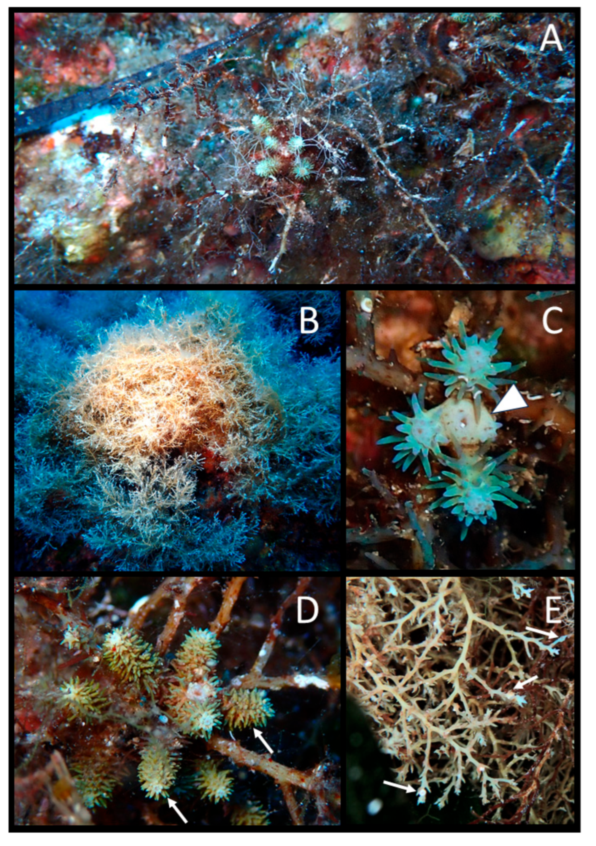
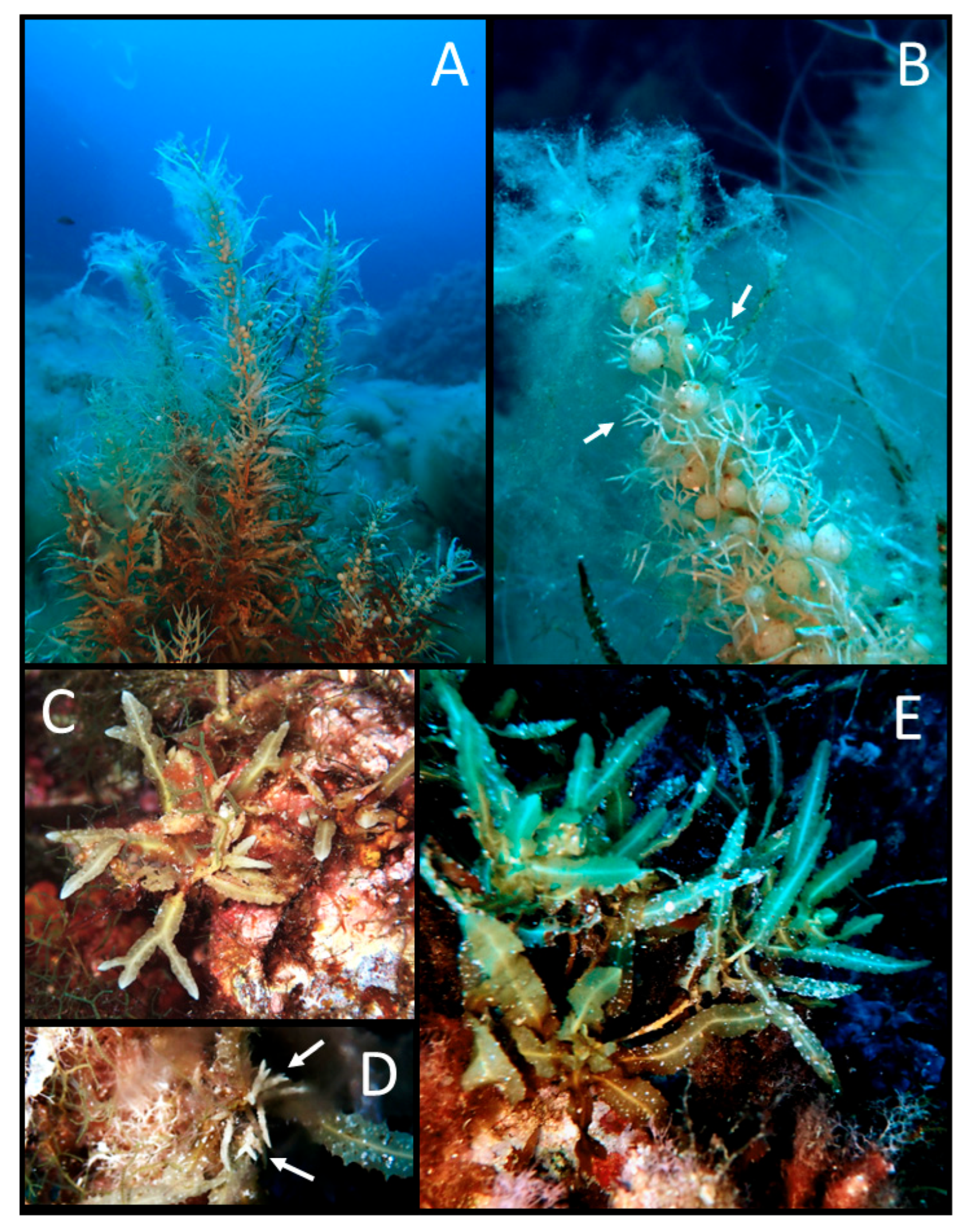
  • Sargassum acinarium (Linnaeus) Setchell (Figure 14A,B)
Morphological description: Thalli with a single cylindrical axis, rough, or knotty, attached to the substrate by a discoid holdfast (Figure 14A). Primary branches are cylindrical and bear narrow foliaceous branches with wavy to toothed margins, an acute to slightly rounded apex, and a central midrib. Aerocysts are spherical and borne on a cylindrical pedicel, typically on the upper thallus portion (Figure 14B). Receptacles are cylindrical, slender, simple, or bifurcated, and borne at the base of a pedicel at the axil of the foliaceous branches (Figure 14B).
Habitat: This species was recorded in both campaigns: in autumn, in zone A (Cala Sidoti, during both snorkeling and scuba diving) and zone C (Punta dell’Arpa), whereas in summer, it was recorded in zone B (Secca della Colombara). In autumn, it occurred from 0.1 to 35 m as scattered individuals; in summer, it was detected at 25–30 m as scattered individuals.
Remarks: Sargassum acinarium was previously reported at Ustica Island by Catra et al. [16].
Morphological description: Thalli with a single cylindrical, rough and knotty axis, attached by a discoid holdfast. The axis is typically divided into spaced branches with a fan-shaped architecture (Figure 14C). Primary branches are knotty and feature foliose branches, which can be divided up to four times, lanceolate or lobate (Figure 14C), with pointed apexes, smooth or toothed margins, and a conspicuous midrib following branch bifurcation. Aerocysts were not observed. Receptacles are cylindrical to lanceolate, warty, simple, or bifurcated, forming clusters at the axils of foliose branches (Figure 14D).
Habitat: This species was recorded in both campaigns as scattered individuals: in zone B (Scoglio del Medico in autumn; Secca della Colombara in summer) and zone C (Punta dell’Arpa in autumn; Punta Homo Morto in summer). In autumn, it occurred at 10 to 25 m, while in summer, it occurred at 3–11 m.
Remarks: This represents the first record of S. furcatum for Ustica Island. This species, with an Atlantic and Pacific distribution [41], was first reported in the Mediterranean from Flores-Moya and Conde on the Chafarinas Islands (Spanish territories off the Moroccan coast) [46]. In recent years, it has been reported from several localities around Sicily [47], the French Mediterranean coastline, and Corsica [40]. Its expanding trend in Sicily has been documented [47], and, given its affinity for warm waters, it might indicate further evidence of the tropicalization of the Mediterranean.
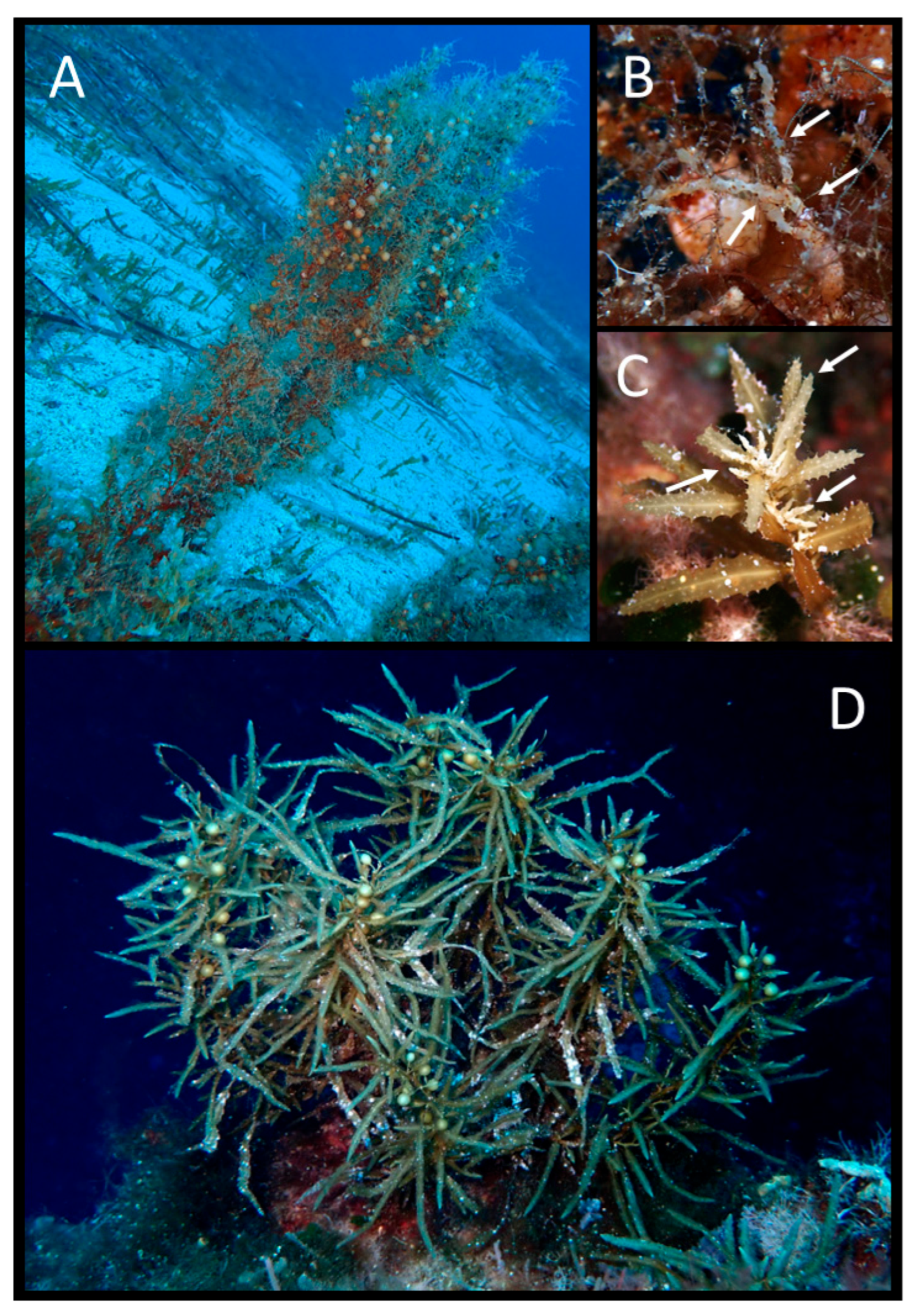
Figure 14. Sargassum acinarium. (A) Summer habit; (B) receptacles (arrows); S. furcatum. (C) Autumn habit; (D) receptacles (arrows); S. cf hornschuchii. (E) Autumn habit.
Environments 13 00101 g014
  • Sargassum cf. hornschuchii C. Agardh (Figure 14E)
Morphological description: Thalli have a single cylindrical, smooth axis, attached to the substrate by a discoid holdfast. Primary branches are flattened, with serrated wings at the base, and become cylindrical distally. Foliose branches are wide (especially near the base), lanceolate, with a distichous-alternating arrangement, a central midrib, and entire, smooth or slightly toothed margins (Figure 14E). Aerocysts and receptacles were not observed.
Habitat: This species was recorded only during the autumn campaign in zone B (Scoglio del Medico) at 17–19 m as abundant patches.
Remarks: The identification remains uncertain because fertile material was not observed. However, S. hornschuchii was previously reported at Ustica Island by Giaccone [10,11] and Giaccone et al. [12], from 18 to 64 m. The recent report from Menorca, after no reports for more than a century, suggests that this species may be under-recorded and/or locally recovering, and that deep waters may represent reservoirs of biodiversity requiring protection [54].
  • Sargassum trichocarpum J. Agardh (Figure 15A,B)
Morphological description: Thalli have a single cylindrical, smooth axis attached by a discoid holdfast (Figure 15A). Primary branches are cylindrical and smooth. Foliose branches are elongated and narrow, with wavy to serrated margins and a central midrib. Aerocysts are spherical to slightly elongated, sometimes with a small spine, and are borne on a cylindrical pedicel. Receptacles are slender, simple, or shortly pedicellate and are repeatedly divided in the same plane (Figure 15B).
Habitat: This species was recorded in both campaigns: in autumn in zone C (Punta dell’Arpa and Punta Galera), and in summer in zone B (Scoglio del Medico and Secca della Colombara). In autumn, it occurred as scattered individuals at 20–33 m, while in summer, it occurred at 20–30 m as scattered individuals at Secca della Colombara and as abundant patches at Scoglio del Medico.
Remarks: This represents the first report of S. trichocarpum for Ustica Island. This finding is particularly relevant since this species has declined in many Mediterranean areas due to habitat loss, pollution, decrease in water transparency, fishing-related impacts, overgrazing, and seawater warming [55].
Figure 15. Sargassum trichocarpum. (A) Summer habit; (B) receptacles (arrows); S. vulgare. (C) Receptacles (arrows); (D) summer habit.
Environments 13 00101 g015
Morphological description: Thalli have a single cylindrical, knotty axis, simple or branched, attached to the substratum by a discoid holdfast. Primary branches are cylindrical and knotty. Foliose branches show an alternate-distichous arrangement and are lanceolate, with a conspicuous midrib, wavy to toothed margin, and an acute apex (Figure 15C). Aerocysts are spherical, with a cylindrical pedicel, and occur at the axil of the foliose branches (Figure 15D). Receptacles are cylindrical to slightly flattened, warty, simple, or branched, and borne on a short sterile pedicel (Figure 15C).
Habitat: This species was recorded in both campaigns: in autumn in zones A (Cala Sidoti, during snorkeling) and zone B (Faro Punta Cavazzi and Scoglio del Medico), whereas in summer, it was recorded in zone B (Scoglio del Medico, Secca della Colombara, and Faro Punta Cavazzi) and zone C (Punta Homo Morto). In autumn, it occurred from 0.1 to 20 m as scattered individuals (Cala Sidoti and Faro Punta Cavazzi) or abundant patches (Scoglio del Medico). In summer, it occurred as scattered individuals from 0.1 to 15 m.
Remarks: Sargassum vulgare was previously reported at Ustica Island by Giaccone et al. [12], Drago et al. [15], and Catra et al. [16], at 8–10 m.

Supplementary Materials

The following supporting information can be downloaded at https://www.mdpi.com/article/10.3390/environments13020101/s1, Table S1: Distribution of the species including MPA protection zone, site and campaign.

Author Contributions

Conceptualization, A.M.M. and D.S.; methodology, G.M., A.L., G.A., A.B. and M.T.; software, A.B., M.T. and M.C.A.; validation, A.M.M. and D.S.; data curation, G.M., A.B., M.T., M.C.A., A.M.M. and D.S.; writing—original draft preparation, G.M.; writing—review and editing, A.M.M., D.S. and A.F.; supervision, A.M.M., D.S. and M.T.; project administration, D.B. and G.A.; funding acquisition, A.M.M., D.S. and D.B. All authors have read and agreed to the published version of the manuscript.

Funding

This research was funded by the European Union—NextGenerationEU; award number: Project code CN_00000033, Concession Decree No. 1034 of 17 June 2022 adopted by the Italian Ministry of University and Research, CUP B83C22002930006, Project title “National Biodiversity Future Center—NBFC” and by the University of Catania under the grant “PIACERI, PIAno di inCEntivi per la Ricerca di Ateneo 2024–2026, Linea di Intervento 1 “Progetti di ricerca collaborativa” (unnumbered).

Data Availability Statement

The original contributions presented in this study are included in the article. Further inquiries can be directed at the corresponding author.

Acknowledgments

The authors would like to thank Francesco Taranto (MPA “Isola di Ustica”) for his invaluable technical support during the sea sampling activities.

Conflicts of Interest

The authors declare no conflicts of interest.

References

  1. Salm, R.V.; Clark, J.R.; Siirila, E. Marine and Coastal Protected Areas: A Guide for Planners and Managers; IUCN: Washington, DC, USA, 2000. [Google Scholar]
  2. Eagles, P.F.J.; McCool, S.F.; Haynes, C.D.A. Sustainable Tourism in Protected Areas: Guidelines for Planning and Management; IUCN: Gland, Switzerland, 2002. [Google Scholar]
  3. Murray, S.N.; Ambrose, R.F.; Bohnsack, J.A.; Botsford, L.W.; Carr, M.H.; Davis, G.E.; Dayton, P.K.; Gotshall, D.; Gunderson, D.R.; Hixon, M.A.; et al. No-take Reserve Networks: Sustaining Fishery Populations and Marine Ecosystems. Fisheries 1999, 24, 11–25. [Google Scholar] [CrossRef] [Scilit]
  4. Ward, T.J.; Heinemann, D.; Evans, N. The Role of Marine Reserves as Fisheries Management Tools: A Review of Concepts, Evidence and International Experience; Bureau of Rural Sciences: Canberra, Australia, 2001. [Google Scholar]
  5. Mosquera, I.; Côté, I.M.; Jennings, S.; Reynolds, J.D. Conservation benefits of marine reserves for fish populations. Anim. Conserv. 2000, 3, 321–332. [Google Scholar] [CrossRef] [Scilit]
  6. Halpern, B.S.; Warner, R.R. Matching marine reserve design to reserve objectives. Proc. R. Soc. Lond. Ser. B Biol. Sci. 2003, 270, 1871–1878. [Google Scholar] [CrossRef] [Scilit] [PubMed]
  7. Tunesi, L.; Diviacco, G. Environmental and socio-economic criteria for the establishment of marine coastal parks. Int. J. Environ. Stud. 1993, 43, 253–259. [Google Scholar] [CrossRef] [Scilit]
  8. Sanfilippo, M.; Pulicanò, G.; Manganaro, A.; Reale, A.; Cortese, G. Tyrrhenian Upper Waters in the Ustica Island (Marine Protected Area, Sicily, Italy). Int. J. Ecol. 2009, 2009, 161609. [Google Scholar] [CrossRef] [Scilit]
  9. Hogg, K.; Noguera-Méndez, P.; Semitiel-García, M. Lessons from three north-western Mediterranean MPAs: A governance analysis of Port-Cros National Park, Tavolara Punta-Coda Cavallo and Ustica. Mar. Policy 2021, 127, 102943. [Google Scholar] [CrossRef] [Scilit]
  10. Giaccone, G. Popolamenti a Laminaria rodriguezii Bornet sul Banco Apollo dell’isola di Ustica (mar Tirreno). Nova Thalass. 1967, 3, 1–10. [Google Scholar]
  11. Giaccone, G. Contributo allo studio fitosociologico dei popolamenti algali del Basso Tirreno. Ann. Dell’università Ferrara Nuova Ser. Sez. IV Bot. 1971, 4, 17–43. [Google Scholar]
  12. Giaccone, G.; Alessi, M.C.; Toccaceli, M. Flora e vegetazione marina dell’isola di Ustica. Boll. Acc. Gioenia Sci. Nat. 1985, 18, 505–536. [Google Scholar]
  13. Milazzo, M.; Chemello, R.; Badalamenti, F.; Riggio, S. Molluscan assemblages associated with photophilic algae in the Marine Reserve of Ustica Island (Lower Tyrrhenian Sea, Italy). Ital. J. Zool. 2000, 67, 287–295. [Google Scholar] [CrossRef] [Scilit]
  14. Badalamenti, F.; Cantone, G.; Domina, R.; Di Pietro, N.; Catalano, D.; Mollica, E.; D’Anna, G. Primi dati sulla fauna a policheti di substrato duro dell’infralitorale fotofilo superiore dell’Isola di Ustica. Biol. Mar. Mediterr. 1999, 6, 230–236. [Google Scholar]
  15. Drago, D.; Catra, M.; Giaccone, G.; Giardina, S.; Grimaldi, S.; Mannino, A.M. La flora e la vegetazione sommersa del porto di Cala Santa Maria nell’Isola di Ustica (PA): Contributo allo studio di impatto ambientale (S.I.A.). Boll. Acc. Gioenia Sci. Nat. 2004, 37, 265–291. [Google Scholar]
  16. Catra, M.; Drago, D.; Giaccone, T.; Giardina, S.; Nicastro, A. Biodiversità vegetale marina dell’Isola di Ustica (Palermo). Boll. Acc. Gioenia Sci. Nat. 2005, 38, 199–211. [Google Scholar]
  17. Dipartimento di Geologia e Geodesia Dell’università di Palermo. Progetto GE.B.EC.SUD: Relazione finale sui campionamenti e le analisi effettuate nelle isole di Marettimo e Ustica. In Rapporto Tecnico; Dipartimento di Geologia e Geodesia Dell’università di Palermo: Palermo, Italy, 2004; pp. 1–53. [Google Scholar]
  18. Giaccone, T.; Giaccone, G.; Mannino, A.M. Deep rhodolith beds in the Ustica island (Sicily, Southern Tyrrhenian sea): A sedimentary and paleoecological approach. Geogr. Fis. Dinam. Quat. 2018, 41, 47–63. [Google Scholar] [CrossRef] [Scilit]
  19. Sala, E.; Ballesteros, E.; Dendrinos, P.; Di Franco, A.; Ferretti, F.; Foley, D.; Fraschetti, S.; Friedlander, A.; Garrabou, J.; Guclusoy, H.; et al. The structure of Mediterranean rocky reef ecosystems across environmental and human gradients, and conservation implications. PLoS ONE 2012, 7, e32742. [Google Scholar] [CrossRef] [Scilit] [PubMed]
  20. Rendina, F.; Falace, A.; Alongi, G.; Buia, M.C.; Neiva, J.; Appolloni, L.; Marletta, G.; Russo, G.F. The Lush Fucales Underwater Forests off the Cilento Coast: An Overlooked Mediterranean Biodiversity Hotspot. Plants 2023, 12, 1497. [Google Scholar] [CrossRef] [Scilit]
  21. Mangialajo, L.; Chiantore, M.; Cattaneo-Vietti, R. Loss of fucoid algae along a gradient of urbanisation, and structure of benthic assemblages. Mar. Ecol. Prog. Ser. 2008, 358, 63–74. [Google Scholar] [CrossRef] [Scilit]
  22. Piazzi, L.; Bonaviri, C.; Castelli, A.; Ceccherelli, G.; Costa, G.; Curini-Galletti, M.; Langeneck, J.; Manconi, R.; Montefalcone, M.; Pipitone, C.; et al. Biodiversity in canopy-forming algae: Structure and spatial variability of the Mediterranean Cystoseira assemblages. Estuar. Coast. Shelf Sci. 2018, 207, 132–141. [Google Scholar] [CrossRef] [Scilit]
  23. Hereu, B.; Mangialajo, L.; Ballesteros, E.; Thibaut, T. On the occurrence, structure and distribution of deep-water Cystoseira (Phaeophyceae) populations in the Port-Cros National Park (northwestern Mediterranean). Eur. J. Phycol. 2008, 43, 263–273. [Google Scholar] [CrossRef] [Scilit]
  24. Sant, N.; Ballesteros, E. Depth distribution of canopy-forming algae of the order Fucales is related to their photosynthetic features. Mar. Ecol. 2021, 42, e12651. [Google Scholar] [CrossRef] [Scilit]
  25. Sant, N.; Ballesteros, E. Photosynthetic performances of two deep-water canopy-forming fucoids across a depth gradient: Interspecific variability and short-term adaptation to the light environment. Mar. Ecol. 2021, 42, e12666. [Google Scholar] [CrossRef] [Scilit]
  26. Ballesteros, E.; Sant, N. Homogeneity of photosynthetic features in canopy-forming macroalgae of the order Fucales from shallow and sheltered environments. Cryptogam. Algol. 2022, 43, 107–115. [Google Scholar] [CrossRef] [Scilit]
  27. Smith, C.J.; Verdura, J.; Papadopoulou, N.; Fraschetti, S.; Cebrian, E.; Fabbrizzi, E.; Monserrat, M.; Drake, M.; Bianchelli, S.; Danovaro, R.; et al. A decision-support framework for the restoration of Cystoseira sensu lato forests. Front. Mar. Sci. 2023, 10, 1159262. [Google Scholar] [CrossRef] [Scilit]
  28. Thibaut, T.; Pinedo, S.; Torras, X.; Ballesteros, E. Long-term decline of the populations of Fucales (Cystoseira spp. and Sargassum spp.) in the Albères coast (France, North-western Mediterranean). Mar. Pollut. Bull. 2005, 50, 1472–1489. [Google Scholar] [CrossRef] [Scilit]
  29. Pinedo, S.; Zabala, M.; Ballesteros, E. Long-term changes in sublittoral macroalgal assemblages related to water quality improvement. Bot. Mar. 2013, 56, 461–469. [Google Scholar] [CrossRef] [Scilit]
  30. Iveša, L.; Djakovac, T.; Devescovi, M. Long-term fluctuations in Cystoseira populations along the west Istrian Coast (Croatia) related to eutrophication patterns in the northern Adriatic Sea. Mar. Pollut. Bull. 2016, 106, 162–173. [Google Scholar] [CrossRef] [Scilit]
  31. Mancuso, F.P.; Strain, E.M.A.; Piccioni, E.; De Clerck, O.; Sarà, G.; Airoldi, L. Status of vulnerable Cystoseira populations along the Italian infralittoral fringe, and relationships with environmental and anthropogenic variables. Mar. Pollut. Bull. 2018, 129, 762–771. [Google Scholar] [CrossRef] [Scilit] [PubMed]
  32. De Vita, S.; Martin, F.F. The palaeogeographic setting and the local environmental impact of the 130 ka Falconiera tuff-cone eruption (Ustica island, Italy). Ann. Geophys. 2017, 60, S0224. [Google Scholar] [CrossRef] [Scilit]
  33. Giese, P.; Morelli, C. La struttura della crosta terrestre in Italia. Accad. Naz. Lincei 1973, 183, 317–362. [Google Scholar]
  34. Harmelin-Vivien, M.L.; Harmelin, J.G.; Chauvet, C.; Duval, C.; Galzin, R.; Lejeune, P.; Barnabé, G.; Blanc, F.; Chevalier, R.; Duclerc, J.; et al. The underwater observation of fish communities and fish populations: Methods and problems. Rev. Ecol. Terre Vie 1985, 40, 467–540. [Google Scholar]
  35. La Mesa, G.; Salvati, E.; Agnesi, S.; Tunesi, L. Assessment of coastal fish assemblages before the establishment of a new marine protected area in central Mediterranean: Its role in formulating zoning proposal. Mediterr. Mar. Sci. 2017, 18, 11–21. [Google Scholar] [CrossRef] [Scilit]
  36. Thibaut, T.; Blanfuné, A.; Boudouresque, C.F.; Cottalorda, J.M.; Hereu, B.; Susini, M.L.; Verlaque, M. Unexpected temporal stability of Cystoseira and Sargassum forests in Port-Cros, one of the oldest Mediterranean marine National Parks. Cryptogam. Algol. 2016, 37, 61–90. [Google Scholar] [CrossRef] [Scilit]
  37. Gómez-Garreta, A.; Barceló-Martí, M.C.; Ribera-Siguan, M.A.; Rull-Lluch, J. Cystoseira C. Agardh. In Flora Phycologica Iberica, 1st ed.; Gómez-Garreta, A., Ed.; Universidade de Murcia: Múrcia, Spain, 2001; Volume 1, pp. 99–166. [Google Scholar]
  38. Cormaci, M.; Furnari, G.; Catra, M.; Alongi, G.; Giaccone, G. Flora marina bentonica del Mediterraneo: Phaeophyceae. Boll. Accad. Gioenia Sci. Nat. Catania 2012, 45, 375. [Google Scholar]
  39. Rodríguez-Prieto, C.; Ballesteros, E.; Boisset, F.; Afonso Carrilo, J. Guía de Las Macroalgas y Fanerógamas Marinas del Mediterráneo Occidental; Ediciones Omega: Barcelona, Spain, 2013; pp. 1–656. [Google Scholar]
  40. Blanfuné, A.; Verlaque, M.; Boudouresque, C.F.; Rozis, E.; Thibaut, T. Les Forêts Marines de France et de Méditerranée. Guide de Détermination des Espèces-Ingénieurs. Sargassaceae, Fucales, Phaeophyceae; Presses Universitaries de Provence: Marseille, France, 2022; pp. 1–207. [Google Scholar]
  41. AlgaeBase. Available online: https://www.algaebase.org (accessed on 12 October 2025).
  42. Heberle, H.; Meirelles, G.V.; da Silva, F.R.; Telles, G.P.; Minghim, R. InteractiVenn: A web-based tool for the analysis of sets through Venn diagrams. BMC Bioinform. 2015, 16, 169. [Google Scholar] [CrossRef] [Scilit]
  43. Riggio, S.; Milazzo, M. Ricchezza specifica e biodiversità marina nell’isola di Ustica. Nat. Sicil. 2004, 28, 559–586. [Google Scholar]
  44. Bonaviri, C.; Fernández, T.V.; Badalamenti, F.; Gianguzza, P.; Di Lorenzo, M.; Riggio, S. Fish versus starfish predation in controlling sea urchin populations in Mediterranean rocky shores. Mar. Ecol. Prog. Ser. 2009, 382, 129–138. [Google Scholar] [CrossRef] [Scilit]
  45. Aouissi, M.; Sellam, L.N.; Boudouresque, C.F.; Blanfuné, A.; Derbal, F.; Frihi, H.; Perret-Boudouresque, M.; Rebzani-Zahaf, C.; Verlaque, M.; Thibaut, T. Insights into the species diversity of the genus Sargassum (Phaeophyceae) in the Mediterranean Sea, with a focus on a previously unnoticed taxon from Algeria. Mediterr. Mar. Sci. 2018, 19, 48–57. [Google Scholar] [CrossRef] [Scilit]
  46. Flores-Moya, A.; Conde, F. Fragmentos taxonómicos, corológicos, nomenclaturales y fitosociológicos (67–74). Acta Bot. Malacit. 1998, 23, 197–228. [Google Scholar]
  47. Marletta, G.; Lombardo, A.; Serio, D.; Mannino, A.M. The Fucalean Forests of the Island of Lampedusa (Pelagie Islands Marine Protected Area, Central Mediterranean): Past and Present Diversity and Distribution. Coasts 2025, 5, 43. [Google Scholar] [CrossRef] [Scilit]
  48. Ballesteros, E.; Weitzmann, B. On the presence of a small population of Sargassum trichocarpum J. Agardh (Phaeophyceae: Fucales) in Catalonia (Northwestern Mediterranean). Butl. Inst. Catalana Hist. Nat. 2021, 85, 83–85. [Google Scholar]
  49. Verlaque, M.; Boudouresque, C.F.; Perret-Boudouresque, M. Mediterranean seaweeds listed as threatened under the Barcelona Convention: A critical analysis. Sci. Rep. Port-Cros Natl. Park 2019, 33, 179–214. [Google Scholar]
  50. Gianni, F.; Bartolini, F.; Airoldi, L.; Ballesteros, E.; Francour, P.; Guidetti, P.; Meinesz, A.; Thibaut, T.; Mangialajo, L. Conservation and restoration of marine forests in the Mediterranean Sea and the potential role of Marine Protected Areas. AIOL J. 2013, 4, 83–101. [Google Scholar] [CrossRef] [Scilit]
  51. Neiva, J.; Bermejo, R.; Medrano, A.; Capdevila, P.; MillaFigueras, D.; Afonso, P.; Ballesteros, E.; Sabour, B.; Serio, D.; Nóbrega, E.; et al. DNA barcoding reveals cryptic diversity, taxonomic conflicts and novel biogeographical insights in Cystoseira. L. (Phaeophyceae). Eur. J. Phycol. 2022, 58, 351–375. [Google Scholar] [CrossRef] [Scilit]
  52. Hamel, G. Phéophycées de France; Fasc. V.; Rouen-Imprimerie Wolf: Paris, France, 1939. [Google Scholar]
  53. Molinari-Novoa, E.A.; Guiry, M.D. Reinstatement of the genera Gongolaria Boehmer and Ericaria Stackhouse (Sargassaceae, Phaeophyceae). Not. Algarum 2020, 172, 1–10. [Google Scholar]
  54. Ballesteros, E.; de Caralt, S.; Cebrian, E. Back from presumed local extinction: The case of Sargassum hornschuchii C.Agardh (Fucales: Heterokontophyta) in the Spanish Mediterranean. Cryptogam. Algol. 2025, 46, 81–88. [Google Scholar]
  55. Thibaut, T.; Blanfuné, A.; Verlaque, M.; Boudouresque, C.-F.; Ruitton, S. The Sargassum conundrum: Very rare, threatened or locally extinct in the NW Mediterranean and still lacking protection. Hydrobiologia 2016, 781, 3–23. [Google Scholar] [CrossRef] [Scilit]
Figure 1. Maps illustrating the geographical setting of the study area. (A) Location of Ustica Island in the Mediterranean Sea, and (B) its position relative to Sicily. (C) Zoning scheme of the Ustica Island Marine Protected Area (MPA): zone A (red), zone B (yellow), zone C (blue). (D) Ustica Island MPA showing investigated sites. For station abbreviations, refer to Table 1, suffixes -A and -S denote autumn and summer, respectively. (Figures (A,B) were created with Google Earth; (C,D) were created with Manifold® System 8).
Environments 13 00101 g001
Figure 2. Total number of taxa recorded across both campaigns, and number of taxa recorded per campaign, in the three protection zones of Ustica Island MPA.
Environments 13 00101 g002
Figure 3. Number of records per taxon in the three protection zones of Ustica Island MPA.
Environments 13 00101 g003
Figure 4. Number of taxa recorded per campaign in each sector of the island.
Environments 13 00101 g004
Figure 5. Venn diagrams illustrating the comparison between current and historical data (see Table 2): (A) historical data across the three protection zones; (B) current vs. historical data in zone A; (C) current vs. historical data in zone B; and (D) current vs. historical data in zone C.
Environments 13 00101 g005
Table 1. Details of survey sites, including MPA protection zones (as in Figure 1), abbreviations, GPS coordinates, survey date, and activity.
MPA
Protection Zone
Survey SiteAbbreviationGPS CoordinatesDate
(Autumn)
Date
(Summer)
Activity
ACala SidotiCS38°42.499′ N13°9.578′ E28 September 2024
2 October 2024
13 June 2025Scuba dive-Snorkeling
BScoglio del MedicoSM38°42.893′ N13°9.333′ E1 October 202410 June 2025Scuba dive-Snorkeling
BPiramidiPI38°42.126′ N13°9.075′ E-13 June 2025Scuba dive
BFaro Punta CavazziFPC38°41.655′ N13°9.170′ E28 September 202411 June 2025Snorkeling
BSecca della ColombaraSC38°43.787′ N13°10.811′ E-11 June 2025Scuba dive-Snorkeling
BTorre SpalmatoreTS38°42.017′ N13°9.196′ E28 September 2024-Snorkeling
BGorgo Salato e FaraglioneGSF38°43.229′ N13°10.926′ E1 October 2024-Snorkeling
CPunta dell’ArpaPdA38°41.417′ N13°10.387′ E30 September 202412 June 2025Scuba dive-Snorkeling
CPastizzaPA38°42.114′ N13°11.663′ E-10 June 2025Scuba dive-Snorkeling
CZia LisaZL38°41.490′ N13°9.397′ E-11 June 2025Snorkeling
CPunta GaleraPG38°41.673′ N13°10.977′ E30 September 202414 June 2025Scuba dive-Snorkeling
CPiscina NaturalePN38°41.566′ N13°9.223′ E-14 June 2025Snorkeling
CPunta Homo MortoPHM38°42.684′ N13°12.008′ E27 September 202412 June 2025Scuba dive-Snorkeling
CVillaggio dei pescatoriVP38°42.492′ N13°11.955′ E29 September 2024-Snorkeling
Table 2. Fucalean species found at Ustica Island MPA: comparison between the present study and the previous ones. x = presence.
Present StudyPrevious Studies
TaxaAutumnSummerGiaccone [10]Giaccone [11]Giaccone et al. [12]Milazzo et al. [13]Badalamenti et al. [14]Drago et al. [15]Catra et al. [16]Ge.B.Ec.Sud [17]Giaccone et al. [18]
Cystoseira compressa (Esper) Gerloff & Nizamuddinxx as Cystoseira compressa f. compressaas Cystoseira compressaas Cystoseira compressaas Cystoseira compressa f. compressaas Cystoseira compressa f. compressaas Cystoseira compressa
Cystoseira foeniculacea (Linnaeus) Greville
f. foeniculacea
xxas Cystoseira discors
Cystoseira foeniculacea
f. latiramosa (Ercegovic) A.Gómez Garreta et al.
xxas Cystoseira discors f. latiramosaas Cystoseira discors f. latiramosaas Cystoseira ercegovicii f. latiramosa as Cystoseira foeniculacea f. latiramosaas Cystoseira foeniculacea f. latiramosa
Cystoseira foeniculacea
f. tenuiramosa (Ercegović) A.Gómez Garreta et al.
xx as Cystoseira ercegovicii f. tenuiramosaas Cystoseira schiffneri f. tenuiramosaas Cystoseira schiffneri f. tenuiramosa as Cystoseira foeniculacea f. tenuiramosa
Cystoseira pelagosae Ercegovic cf. as Cystoseira pelagosae
Cystoseira pustulata (Ercegovic) Neiva & Serrãoxx as Cvstoseira humilis
Ericaria amentacea (C. Agardh) Molinari & Guiryxx as Cystoseira strictaas Cystoseira stricta as Cystoseira amentacea v. stricta as Cystoseira amentacea v. stricta
Ericaria balearica (Sauvageau) Neiva, Ballesteros & Serrãox as Cystoseira balearicaas Cystoseira brachycarpa v. balearicaas Cystoseira brachycarpa v. balearica as Cystoseira brachycarpa v. balearica
Ericaria brachycarpa (J. Agardh) Molinari & Guiry var. brachycarpaxx as Cystoseira brachycarpa v. brachycarpaas Cystoseira brachycarpaas Cystoseira brachycarpaas Cystoseira brachycarpa v. brachycarpaas Cystoseira brachycarpa v. brachycarpaas Cystoseira brachycarpa
Ericaria brachycarpa var. claudiae Boudouresque, Perret-Boudouresque & Blanfuné as Cystoseira balearica v. claudiae as Cystoseira balearica v. claudiae as Cystoseira balearica v. claudiae
Ericaria crinita (Duby) Molinari & Guiry as Cystoseira crinita
Ericaria dubia (Valiante) Neiva & Serrão as Cystoseira dubia
Ericaria funkii (Gerloff & Nizamuddin) Molinari & Guiryxx as Cystoseira funkiias Cystoseira jabukae
Ericaria zosteroides (C. Agardh) Molinari & Guiry xas Cystoseira opuntioidesas Cystoseira zosteroidesas Cystoseira zosteroides as Cystoseira zosteroides
Gongolaria elegans (Sauvageau) Molinari & Guiryxx as Cystoseira elegansas Cystoseira elegansas Cystoseira elegans as Cystoseira elegans
Gongolaria montagnei (J. Agardh) Kuntze var. montagneixxas Cystoseira spinosaas Cystoseira spinosaas Cystoseira spinosa v. spinosaas Cystoseira spinosaas Cystoseira spinosa v. spinosa as Cystoseira spinosa v. spinosaas Cystoseira spinosa v. spinosa
Gongolaria montagnei var. compressa (Ercegović) Verlaque, et al.xx as Cystoseira spinosa v. compressa as Cystoseira spinosa v. compressa
Gongolaria montagnei var. tenuior (Ercegović) Molinari & Guiryxx as Cystoseira spinosa v. tenuioras Cystoseira spinosa v. tenuior
Gongolaria sauvageauana (Hamel) Molinari & Guiryxx as Cystoseira sauvageauana and as Cystoseira sauvageauna v. polyoedematisas Cystoseira sauvageauana and as Cystoseira sauvageauna v. polyoedematisas Cystoseira sauvageauana and as Cystoseira sauvageauna v. polyoedematis as Cystoseira sauvageauanaas Cystoseira sauvageauana and as Cystoseira sauvageauna v. polyoedematis
Gongolaria squarrosa (De Notaris) Kuntze as Cystoseira spinosa v. squarrosa as Cystoseira spinosa v. squarrosa
Sargassum sp. as Sargassum sp. as Sargassum sp.as Sargassum sp.
Sargassum acinarium (Linnaeus) Setchellxx as Sargassum acinarium
Sargassum furcatum Kützingxx
Sargassum hornschuchii C. Agardhx as Sargassum hornschuchiias Sargassum hornschuchiias Sargassum hornschuchii
Sargassum trichocarpum J. Agardhxx
Sargassum vulgare C. Agardhxx as Sargassum vulgare as Sargassum vulgareas Sargassum vulgare
Total number of species x study1918551679416103
Disclaimer/Publisher’s Note: The statements, opinions and data contained in all publications are solely those of the individual author(s) and contributor(s) and not of MDPI and/or the editor(s). MDPI and/or the editor(s) disclaim responsibility for any injury to people or property resulting from any ideas, methods, instructions or products referred to in the content.